


This water plan may be cited as the Water Plan (Great Artesian Basin) 2006.s 1 sub 2014 Act No. 64 s 250
The following are the purposes of this plan—(a)to define the availability of water in the plan area;(b)to provide a framework for sustainably managing water and the taking of water;(c)to identify priorities and mechanisms for dealing with future water requirements.
The dictionary in schedule 6 defines particular words used in this plan.
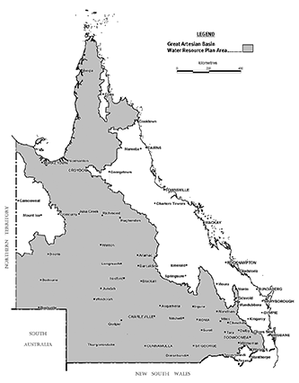
This plan applies to the area shown as the plan area on the map in schedule 1.
5Management areas and management units
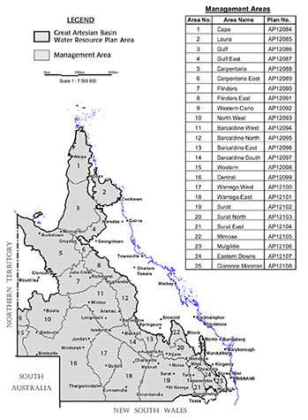
(1)Each management area mentioned in this plan is shown on the map in schedule 2.(2)Each management area mentioned in schedule 4, column 1, is divided into the management units mentioned, for the management area, in schedule 4, column 2.(3)Each management unit comprises the aquifers mentioned, for the management unit, in schedule 4, column 3.
6Maps held in digital electronic form
(1)The exact location of the boundaries on maps shown in schedules 1, 2 and 3 is held in digital electronic form by the department.(2)The information held in digital electronic form can be reduced or enlarged to show the details of each boundary.
This plan applies to the following water in or from management units in the plan area—(a)underground water;(b)water in springs.
8Outcomes, including ecological outcomes, for the plan area
Water is to be allocated and managed in a way that seeks to achieve a balance in the following outcomes—(a)to protect the flow of water to springs and baseflow to watercourses that support significant cultural and environmental values;(b)to provide for the continued use of all water entitlements and other authorisations to take or interfere with water;(c)to reserve water in storage in aquifers for future generations;(d)to ensure a reliable supply of water from the plan area;(e)to make water available for new users.
(1)This part states the strategies for achieving the outcomes mentioned in part 3.(2)The strategies—(a)form part of a broad framework for the management of natural resources; and(b)complement other activities for advancing the sustainable management of water including the Great Artesian Basin Sustainability Initiative.
10Decisions about taking water
(1)The chief executive must not make a decision, about the allocation or management of water in the plan area, that would increase the average volume of water that may be taken in the plan area.(2)A decision mentioned in subsection (1) includes a decision about an application for a water licence, made but not decided before the commencement of this plan.(3)Subsections (1) and (2) do not apply to a decision—(a)about a water permit; or(b)about a water licence for taking or interfering with water only for stock or domestic purposes; or(c)to grant a water licence for the purpose of ‘stock intensive’ to replace a water licence for stock purposes, for a cattle feedlot of not more than 49 standard cattle units, in existence immediately before 1 March 1998; or(d)about a water licence for associated water under the Petroleum and Gas (Production and Safety) Act 2004; or(e)about reinstating or replacing an expired water licence; or(ea)to grant a water licence to the Toowoomba Regional Council of up to 2000ML for town water supply; or(f)to grant a water licence under section 15(b); or(g)to grant a water licence under section 33; or(h)about unallocated water, made under division 4; or(i)about water sharing rules; or(j)required to be made under the resource operations plan.s 10 amd 2014 SL No. 142s 101; 2014 Act No. 64s 251
11Limitation on taking or interfering with water—Act, s 101
(1)In a management area other than Eastern Downs, Mulgildie or Clarence Moreton, a person may not take or interfere with underground water other than—(a)for domestic purposes; or(b)under a water entitlement or other authorisation held before the commencement of this plan; or(c)under an authorisation mentioned in section 10(3).(2)In the Eastern Downs, Mulgildie and Clarence Moreton management areas, a person may not take or interfere with underground water other than—(a)for stock or domestic purposes; or(b)under a water entitlement or other authorisation held before the commencement of this plan; or(c)under an authorisation mentioned in section 10(3).s 11 amd 2013 Act No. 23s 352sch 1 pt 2
sub 2014 Act No. 64s 252
A water licence granted for taking water in the plan area must be consistent with the criteria for the protection of the flow of water to springs and baseflow to watercourses stated in the resource operations plan.
div hdg sub 2014 SL No. 142s 102
s 13 om 2014 SL No. 142s 103
14Continued taking of water in Clarence Moreton management area authorised
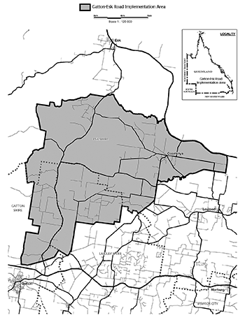
(1)An owner of an existing water bore in the Clarence Moreton management area other than the Gatton–Esk Road implementation area who, on the commencement of this plan, is using the bore to take underground water may continue to use the bore to take water.(2)A person who, on the commencement, is taking underground water in the Clarence Moreton management area to prevent the water entering a mine may continue to take water.s 14 amd 2014 SL No. 142s 104; 2016 SL No. 216 s 146 sch 20
The chief executive may, under section 212 of the Act—(a)grant a water licence to take underground water to a person authorised under section 14 to continue taking water; or(b)grant a water licence to take underground water, for a groundwater-dependent activity, to an owner of land in the Clarence Moreton management area who, in the approved form, satisfies the chief executive that, on 18 August 2005, the owner had—(i)a water bore that allowed taking underground water; and(ii)a commitment to a groundwater-dependent activity.s 15 sub 2014 SL No. 142s 105
16Unallocated water held as general or State reserve
Unallocated water is held as a general or State reserve and dealt with under this division.
Unallocated water may be granted from the general or State reserve under a process in the resource operations plan.
18Matters chief executive must consider
(1)In dealing with unallocated water, the chief executive must consider—(a)the need for, and efficiency of, current and proposed uses of water, including—(i)the extent to which water is being taken under current authorisations in the plan area; and(ii)emerging requirements in the plan area for additional water and the likely timeframe in which the additional water will be required; and(iii)alternative water sources including, for example, recycled water and water savings from improvements in the efficiency of water use; and(b)the availability of an alternative water supply for the purpose for which the water is required; and(c)the impact the proposed taking of, or interfering with, the water may have on—(i)the flow of water to springs or baseflow to watercourses; and(ii)groundwater pressure; and(iii)groundwater levels; and(d)the impact the proposed taking of, or interfering with, the water may have on existing water entitlements and other authorities to take or interfere with water.(2)Subsection (1) does not limit the matters the chief executive may consider.
19Decisions about granting unallocated water for particular purposes
In making a decision about granting unallocated water for a purpose mentioned in section 25(1), the chief executive—(a)must consider whether unallocated water is available to be granted from the State reserve for the purpose; and(b)if unallocated water is available—may require the person wishing to be granted the water to lodge an application for unallocated water from the State reserve.
20Granting water from general or State reserve
(1)The chief executive may require an applicant for water from the general or State reserve to—(a)investigate the likely impact the proposed taking of water may have on groundwater pressure or groundwater levels; and(b)include the results of the investigation with the application.(2)If the chief executive grants a water licence for water from the general or State reserve, the chief executive may impose conditions on the licence requiring the holder of the licence to—(a)provide and maintain access to alternative water supplies for other persons, authorised under the Act to take water, who would be significantly adversely affected by the granting of the licence; and(b)carry out and report on a stated monitoring program.
This subdivision applies to unallocated water that is held as a general reserve.
22Limitation on volume of unallocated water granted
(1)The total of the volumetric limits, for water licences for water granted from the general reserve in a management area mentioned in schedule 5, column 1, is stated opposite the management area in schedule 5, column 2.(2)In granting water from a management area mentioned in schedule 5, column 1, the chief executive must, as far as is practicable, grant the water—(a)from the management units mentioned in schedule 5, column 3 opposite the management area; and(b)for each management unit, in the volume mentioned opposite the management unit in schedule 5, column 4.
23Limitation on use of unallocated water granted
A water licence for water granted under this subdivision for irrigation in the plan area of the Water Resource (Cooper Creek) Plan 2000 may allow irrigating only—(a)an area of not more than 10ha of crops for feeding stock; or(b)an area of not more than 2ha of horticultural crops.
This subdivision applies to unallocated water that is held as a State reserve.
25Limitation on purpose for granting unallocated water
(1)Unallocated water may be granted from the State reserve only for the following purposes—(a)a project of State significance;(b)a project of regional significance;(c)for water granted to a local government—town water supply purposes.(2)Water granted for a project is granted only for the life of the project and the right to take the water returns to the State on the conclusion of the project.
div hdg sub 2014 SL No. 142s 106
25AProjects of regional significance
The chief executive may consider a particular project to be a project of regional significance for the plan area only if the chief executive considers the project is significant for a region in the plan area having regard to the following—(a)the outcomes stated in part 3;(b)the economic or social impact the project will have on the region;(c)the public interest and the welfare of people in the region;(d)any other relevant consideration.s 25A ins 2014 Act No. 40s 154sch 1 pt 5
26Limitation of volume of unallocated water granted
The volumetric limits, for water licences for water granted from the State reserve is—(a)for the Cape management area—a total of 9,800ML; and(b)for all other management areas—a combined total of 10,000ML for all the areas.s 26 sub 2014 Act No. 64s 253
s 27 om 2014 SL No. 142s 107
s 28 om 2014 SL No. 142s 107
s 29 om 2014 SL No. 142s 107
30Granting water from State reserve
The resource operations plan may state the management areas and management units in which water may be granted from the State reserve.
s 31 om 2014 SL No. 142s 108
32Consultation with other States
(1)Subsection (2) applies if—(a)the chief executive proposes to make a decision about the grant or amendment of a water licence; and(b)the decision could have an adverse impact on groundwater pressure or groundwater levels at the border of Queensland and another State.(2)The chief executive must consult with the other State before making the decision.
33Water licence to replace particular authority to take water—Act, s 212
(1)The chief executive may, under section 212 of the Act, grant a water licence to take or continue to take water that could have been taken under an authority under the Act or the repealed Act, in existence on 19 February 2005.(2)In this section—authority under the Act or the repealed Act includes correspondence from the department recording the chief executive’s intention to grant a water licence allowing the taking of water.
34Amendment of water licences to state volumetric limit
(1)This section applies to a water licence to take water in the plan area that does not state a maximum volume of water that may be taken under the licence.(2)The chief executive must, during the period this plan is in force, amend the licence, under section 217 of the Act, to state a volumetric limit.(3)In deciding the volumetric limit, the chief executive must have regard to the following—(a)the conditions of the licence;(b)the efficiency of the current use of water having regard to industry best practice in efficient water use;(c)the impact the taking is having on—(i)the flow of water to springs or baseflow to watercourses; and(ii)groundwater pressure; and(iii)groundwater levels;(d)the sustainable management of water in the management unit to which the licence relates;(e)the impact the taking is having on existing water entitlements and other authorities to take or interfere with water;(f)the availability of an alternative water supply for the purpose for which the water is being taken.(4)Subsection (3) does not limit the matters the chief executive may consider.(5)A water licence, in not stating a maximum volume of water that may be taken, is not inconsistent with this plan if the licence is only—(a)for stock or domestic purposes; or(b)to lower water levels to prevent water entering a mine; or(c)for associated water under the Petroleum and Gas (Production and Safety) Act 2004.
s 35 amd 2009 SL No. 280s 178; 2014 Act No. 29s 150
s 36 om 2014 SL No. 142s 109
pt hdg sub 2014 SL No. 142s 110
37Monitoring and reporting requirements
(1)To help the Minister assess the effectiveness of the management strategies for achieving the outcomes mentioned in part 3, the resource operations plan must state—(a)the monitoring requirements for water and natural ecosystems for this plan; and(b)the reporting requirements for this plan for operators of infrastructure interfering with water in the plan area.(2)Also, monitoring requirements for this plan are to—(a)monitor the flow of water from management units supplying water to springs in the plan area; and(b)monitor baseflow to watercourses in the plan area.(3)The monitoring and reporting requirements are to be achieved by—(a)monitoring programs administered by relevant State agencies; and(b)if a water licence requires the holder of the licence to carry out a monitoring program—the program carried out by the holder.(4)Subsections (1) and (2) do not limit the monitoring requirements the chief executive may impose for this plan.s 37 sub 2014 SL No. 142s 110
s 38 sub 2014 SL No. 142s 110
s 39 om 2014 SL No. 142s 110
s 40 om 2014 SL No. 142s 111
41Stated amendment of plan—Act, s 56(4)
An amendment to vary the volume of water that may be granted from the general or State reserve may be made to this plan under section 56(4) of the Act.
42Minor or stated amendments of plan—Act, 57(b)
Minor amendments of the boundaries of management areas may be made to this plan under section 57(b) of the Act.
section 5(1)
sch 6, definition Gatton–Esk Road implementation area
Column 1 | Column 2 | Column 3 |
Management areas | Management units | Aquifers |
Barcaldine East | Barcaldine East 1 | Westbourne Formation Adori Sandstone Birkhead Formation |
Barcaldine East 2 | Hutton Sandstone Evergreen Formation Boxvale Sandstone Member | |
Barcaldine East 3 | Precipice Sandstone | |
Barcaldine East 4 | Moolayember Formation Warang Sandstone Clematis Sandstone Rewan Formation | |
Barcaldine North | Barcaldine North 1 | Wallumbilla Formation |
Barcaldine North 2 | Cadna-owie Formation Wyandra Sandstone Member Hooray Sandstone Westbourne Formation Adori Sandstone Birkhead Formation Ronlow Beds Hutton Sandstone | |
Barcaldine North 3 | Moolayember Formation Clematis Sandstone | |
Barcaldine South | Barcaldine South 1 | Toolebuc Formation Wallumbilla Formation |
Barcaldine South 2 | Cadna-owie Formation Wyandra Sandstone Member Hooray Sandstone | |
Barcaldine South 3 | Westbourne Formation Adori Sandstone Birkhead Formation Injune Creek Group | |
Barcaldine South 4 | Hutton Sandstone Evergreen Formation Boxvale Sandstone Member | |
Barcaldine South 5 | Precipice Sandstone | |
Barcaldine South 6 | Moolayember Formation Clematis Sandstone | |
Barcaldine West | Barcaldine West 1 | Toolebuc Formation Wallumbilla Formation |
Barcaldine West 2 | Cadna-owie Formation Wyandra Sandstone Member Hooray Sandstone | |
Barcaldine West 3 | Westbourne Formation Adori Sandstone Birkhead Formation Injune Creek Group | |
Barcaldine West 4 | Hutton Sandstone | |
Barcaldine West 5 | Moolayember Formation Clematis Sandstone | |
Cape | Cape 1 | Helby Beds Gilbert River Formation Garraway Beds |
Carpentaria | Carpentaria 1 | Toolebuc Formation Wallumbilla Formation |
Carpentaria 2 | Gilbert River Formation Eulo Queen Group | |
Carpentaria East | Carpentaria East 1 | Toolebuc Formation Wallumbilla Formation |
Carpentaria East 2 | Gilbert River Formation Eulo Queen Group | |
Central | Central 1 | Toolebuc Formation Ranmoor Member Jones Valley Member Coreena Member Doncaster Member Wallumbilla Formation |
Central 2 | Cadna-owie Formation Wyandra Sandstone Member | |
Central 3 | Hooray Sandstone Murta Formation McKinlay Member Namur Sandstone | |
Central 4 | Westbourne Formation Adori Sandstone Birkhead Formation Injune Creek Group | |
Central 5 | Hutton Sandstone Evergreen Formation Boxvale Sandstone Member | |
Central 6 | Poolowanna Formation | |
Central 7 | Moolayember Formation Warang Sandstone Clematis Sandstone Rewan Formation | |
Clarence Moreton | Clarence Moreton 1 | Walloon Coal Measures |
Clarence Moreton 2 | Marburg Sandstone | |
Clarence Moreton 3 | Helidon Sandstone | |
Eastern Downs | Eastern Downs 1 | Walloon Coal Measures |
Eastern Downs 2 | Marburg Sandstone | |
Eastern Downs 3 | Helidon Sandstone | |
Flinders | Flinders 1 | Toolebuc Formation Wallumbilla Formation |
Flinders 2 | Cadna-owie Formation Wyandra Sandstone Member Hooray Sandstone Gilbert River Formation | |
Flinders 3 | Westbourne Formation Adori Sandstone Birkhead Formation Injune Creek Group | |
Flinders 4 | Hutton Sandstone | |
Flinders 5 | Moolayember Formation Clematis Sandstone | |
Flinders East | Flinders East 1 | Toolebuc Formation Wallumbilla Formation |
Flinders East 2 | Cadna-owie Formation Wyandra Sandstone Member Hooray Sandstone Gilbert River Formation | |
Flinders East 3 | Westbourne Formation Adori Sandstone Birkhead Formation Injune Creek Group Eulo Queen Group | |
Flinders East 4 | Hutton Sandstone Ronlow Beds | |
Flinders East 5 | Moolayember Formation Clematis Sandstone Warang Sandstone | |
Gulf | Gulf 1 | Wyaaba Beds |
Gulf 2 | Bulimba Formation | |
Gulf 3 | Rolling Downs Group | |
Gulf 4 | Gilbert River Formation | |
Gulf East | Gulf East 1 | Wyaaba Beds |
Gulf East 2 | Bulimba Formation | |
Gulf East 3 | Rolling Downs Group | |
Gulf East 4 | Gilbert River Formation | |
Laura | Laura 1 | Rolling Downs Group |
Laura 2 | Gilbert River Formation Dalrymple Sandstone | |
Mimosa | Mimosa 1 | Moolayember Formation Clematis Sandstone Rewan Formation |
Mulgildie | Mulgildie 1 | Hutton Sandstone Evergreen Formation |
Mulgildie 2 | Precipice Sandstone | |
North-West | North-West 1 | Wallumbilla Formation |
North-West 2 | Hooray Sandstone Westbourne Formation Adori Sandstone Birkhead Formation Injune Creek Group Hutton Sandstone Evergreen Formation Boxvale Sandstone Member Longsight Sandstone | |
Surat | Surat 1 | Surat Siltstone Coreena Member Doncaster Member Wallumbilla Formation |
Surat 2 | Wyandra Sandstone Member Bungil Formation Minmi Member Nullawart Sandstone Member Kingill Member | |
Surat 3 | Mooga Sandstone | |
Surat 4 | Oralla Formation Gubberamunda Sandstone | |
Surat 5 | Westbourne Formation Springbok Sandstone Birkhead Formation Walloon Coal Measures Eurombah Formation | |
Surat 6 | Hutton Sandstone Evergreen Formation Boxvale Sandstone Member | |
Surat 7 | Precipice Sandstone | |
Surat 8 | Moolayember Formation Clematis Sandstone Rewan Formation | |
Surat East | Surat East 1 | Kumbarilla Beds |
Surat East 2 | Walloon Coal Measures | |
Surat East 3 | Hutton Sandstone Evergreen Formation | |
Surat East 4 | Precipice Formation | |
Surat East 5 | Moolayember Formation Clematis Sandstone | |
Surat North | Surat North 1 | Westbourne Formation Springbok Sandstone Walloon Coal Measures Eurombah Formation |
Surat North 2 | Hutton Sandstone Evergreen Formation | |
Surat North 3 | Precipice Formation | |
Surat North 4 | Moolayember Formation Clematis Sandstone | |
Warrego East | Warrego East 1 | Toolebuc Formation Ranmoor Member Jones Valley Member Coreena Member Doncaster Member Wallumbilla Formation |
Warrego East 2 | Cadna-owie Formation Wyandra Sandstone Member | |
Warrego East 3 | Hooray Sandstone Murta Formation McKinlay Member Namur Sandstone | |
Warrego East 4 | Westbourne Formation Adori Sandstone Birkhead Formation | |
Warrego East 5 | Hutton Sandstone Evergreen Formation | |
Warrego East 6 | Precipice Sandstone | |
Warrego East 7 | Moolayember Formation Warang Sandstone Clematis Sandstone Rewan Formation | |
Warrego West | Warrego West 1 | Toolebuc Formation Ranmoor Member Jones Valley Member Coreena Member Doncaster Member Wallumbilla Formation |
Warrego West 2 | Cadna-owie Formation Wyandra Sandstone Member | |
Warrego West 3 | Hooray Sandstone Murta Formation McKinlay Member Namur Sandstone | |
Warrego West 4 | Westbourne Formation Adori Sandstone Birkhead Formation | |
Warrego West 5 | Hutton Sandstone Evergreen Formation | |
Warrego West 6 | Poolowanna Formation | |
Warrego West 7 | Moolayember Formation Warang Sandstone Clematis Sandstone Rewan Formation | |
Western | Western 1 | Wallumbilla Formation |
Western 2 | Algebuckina Sandstone | |
Western Carlo | Western Carlo 1 | Algebuckina Sandstone |
Column 1 | Column 2 | Column 3 | Column 4 |
Management area | Volume | Management unit | Volume |
Barcaldine North | 500ML | Barcaldine North 2 | 500ML |
Barcaldine South | 1,500ML | Barcaldine South 3 Barcaldine South 4 Barcaldine South 5 | 500ML 500ML 500ML |
Barcaldine West | 3,000ML | Barcaldine West 2 Barcaldine West 3 Barcaldine West 4 Barcaldine West 5 | 500ML 1,000ML 1,000ML 500ML |
Cape | 100ML | Cape 1 | 100ML |
Carpentaria | 400ML | Carpentaria 1 Carpentaria 2 | 100ML 300ML |
Central | 1,000ML | Central 3 | 1,000ML |
Flinders | 2,000ML | Flinders 3 Flinders 4 | 1,000ML 1,000ML |
Flinders East | 100ML | Flinders East 2 | 100ML |
Gulf | 1,100ML | Gulf 2 Gulf 3 Gulf 4 | 100ML 500ML 500ML |
Laura | 500ML | Laura 2 | 500ML |
Mimosa | 500ML | Mimosa 1 | 500ML |
North West | 500ML | North West 2 | 500ML |
Surat | 5,000ML | Surat 6 Surat 7 | 3,000ML 2,000ML |
Surat East | 2,000ML | Surat East 3 Surat East 4 | 1,000ML 1,000ML |
Surat North | 200ML | Surat North 2 Surat North 3 | 100ML 100ML |
Warrego East | 4,000ML | Warrego East 3 Warrego East 4 Warrego East 5 Warrego East 6 | 1,000ML 1,000ML 1,000ML 1,000ML |
Warrego West | 1,000ML | Warrego West 3 | 1,000ML |
sch 5 sub 2014 SL No. 142s 112
baseflow, to a watercourse, means the natural discharge of underground water into the watercourse.
def baseflow amd 2016 SL No. 216 s 146 sch 20
commitment, in relation to a groundwater-dependent activity, means—
(a)if a tree clearing permit is required under the Vegetation Management Act 1999 for the activity—a permit has been granted; and
(b)either—(i)infrastructure for taking or distributing groundwater has been constructed; or(ii)a financial commitment to the construction of the infrastructure has been made; or(iii)local or State government requirements for carrying out the activity have been satisfied, for example, a development permit for the activity is held.Example of financial commitment—
a loan has been granted for the activity on the basis that irrigation would be permitted
existing water bore—
1Existing water bore means a water bore that—(a)allows taking underground water; and(b)was in existence on—(i)for the Mulgildie management area—13 May 2005; or(ii)for the part of the Clarence Moreton management area mentioned in the moratorium notice published on 24 March 2005—18 August 2005; or(iii)for the remainder of the Clarence Moreton management area—on the commencement of this plan.
2The term does not include a water bore that allows taking underground water only for stock or domestic purposes.See section 20 (Authorised taking of water without water entitlement) of the Act.
def existing water bore amd 2016 SL No. 216 s 146 sch 20
Gatton–Esk Road implementation area see schedule 3.
Great Artesian Basin Sustainability Initiative means the agreement between the State and the Commonwealth to subsidise the repair of uncontrolled bores and replace bore drains with piped distribution systems.
groundwater-dependent activity means an activity that uses underground water, for example, growing a crop requiring irrigation, the commercial production of animals or a commercial or industrial enterprise.
def groundwater-dependent activity amd 2016 SL No. 216 s 146 sch 20
lot means—
(a)a lot under the Land Title Act 1994; or
(b)a separate, distinct parcel of land for which an interest is recorded in a register under the Land Act 1994.
management area see section 5.
management unit see section 5.
plan area means the area shown as the plan area on the map in schedule 1.
project of regional significance means a project the chief executive considers to be a project of regional significance under section 25A.
def project of regional significance sub 2014 Act No. 40 s 154 sch 1 pt 5
project of state significance means a project declared under the State Development and Public Works Organisation Act 1971 to be a coordinated project.
def project of state significance amd 2014 Act No. 40 s 154 sch 1 pt 5
resource operations plan means the resource operations plan to implement this plan.
See the Act, section 1266.
def resource operations plan amd 2016 SL No. 216 s 146 sch 20
this plan means this water resource plan.
volumetric limit, for a water licence, has the same meaning as volumetric limit has in the Act, section 120B, for a water allocation.
works replacing works ...
def works replacing works om 2017 SL No. 103 s 158