


This water plan may be cited as the Water Plan (Fitzroy Basin) 2011.s 1 sub 2014 Act No. 64 s 255 sch 2
The following are the purposes of this plan—(a)to define the availability of water in the plan area;(b)to provide a framework for sustainably managing water and the taking of water;(c)to identify priorities and mechanisms for dealing with future water requirements;(d)to provide a framework for establishing water allocations;(e)to provide a framework for reversing, where practicable, degradation in natural ecosystems;(f)to regulate the taking of overland flow water;(g)to regulate the taking of groundwater.
The dictionary in schedule 13 defines particular words used in this plan.
This plan applies to the area shown as the plan area on the map in schedule 1.
Each part of the plan area that is within a subcatchment area shown on the map in schedule 2 is a subcatchment area for this plan.
Each part of the plan area that is within a groundwater management area shown on the map in schedule 3 is a groundwater management area for this plan.
7Groundwater units and groundwater sub-areas
(1)The Callide groundwater management area consists of the following (each a groundwater unit)—(a)Callide Groundwater Unit 1, containing the aquifers of the quaternary alluvium;(b)Callide Groundwater Unit 2, containing all subartesian aquifers within the Callide groundwater management area other than the aquifers included in Callide Groundwater Unit 1.(2)Each of the following areas of the Callide Groundwater Unit 1 shown on map A in schedule 4 is a groundwater sub-area for this plan—(a)Upper Callide groundwater sub-area;(b)Lower Callide groundwater sub-area;(c)Prospect Creek groundwater sub-area;(d)Don and Dee groundwater sub-area.(2A)Each part of the plan area shown as a groundwater sub-area zone for the Upper Callide groundwater sub-area on map A in schedule 4 is a groundwater sub-area zone for that groundwater sub-area.(2B)Each part of the plan area shown as a groundwater sub-area zone for the Lower Callide groundwater sub-area on map A in schedule 4 is a groundwater sub-area zone for that groundwater sub-area.(2C)Each part of the plan area shown as a groundwater sub-area zone for the Prospect Creek groundwater sub-area on map A in schedule 4 is a groundwater sub-area zone for that groundwater sub-area.(2D)Each part of the plan area shown as a groundwater sub-area zone for the Don and Dee groundwater sub-area on map A in schedule 4 is a groundwater sub-area zone for that groundwater sub-area.(3)The Isaac Connors groundwater management area consists of the following (also each a groundwater unit)—(a)Isaac Connors Groundwater Unit 1, containing the aquifers of the quaternary alluvium;(b)Isaac Connors Groundwater Unit 2, containing all subartesian aquifers within the Isaac Connors groundwater management area other than the aquifers included in Isaac Connors Groundwater Unit 1.(4)The area of Isaac Connors Groundwater Unit 1 shown on map B in schedule 4 is the Isaac Connors Alluvium groundwater sub-area for this plan.(5)The Highlands groundwater management area consists of the following (also each a groundwater unit)—(a)Highlands Groundwater Unit 1, containing the aquifers of the quaternary alluvium;(b)Highlands Groundwater Unit 2, containing all subartesian aquifers within the Highlands groundwater management area other than the aquifers included in Highlands Groundwater Unit 1.(6)The area of Highlands Groundwater Unit 1 shown on map C in schedule 4 is the Sandy Creek Alluvium groundwater sub-area for this plan.(7)The Fitzroy groundwater management area consists of the following (also each a groundwater unit)—(a)Fitzroy Groundwater Unit 1, containing the aquifers of the modern coastal deposits;(b)Fitzroy Groundwater Unit 2, containing all subartesian aquifers within the Fitzroy groundwater management area other than the aquifers included in Fitzroy Groundwater Unit 1.(8)In this section—modern coastal deposits means quaternary colluvial and alluvial sediments in close proximity to the coast in the Fitzroy groundwater management area.quaternary alluvium means the quaternary age alluvial deposits of sand, gravel, silt and clay.s 7 amd 2021 SL No. 71 ss 4, 49(8)
Each part of the plan area shown as a water management area on the map in schedule 3A is a water management area.s 7A ins 2015 SL No. 121s 3
sub 2021 SL No. 71 s 5
(1)Each part of the plan area shown as a water management area zone for the Comet water management area on map A in schedule 3B is a water management area zone for that water management area.(2)Each part of the plan area shown as a water management area zone for the Nogoa Mackenzie water management area on map A in schedule 3B is a water management area zone for that water management area.(3)Each part of the plan area shown as a water management area zone for the Theresa Retreat water management area on map A in schedule 3B is a water management area zone for that water management area.(4)Each part of the plan area shown as a water management area zone for the Dawson Valley water management area on map B in schedule 3B is a water management area zone for that water management area.(5)Each part of the plan area shown as a water management area zone for the Fitzroy water management area on map C in schedule 3B is a water management area zone for that water management area.s 7B ins 2021 SL No. 71 s 6
Each part of the plan area shown as a water licence zone on the map in schedule 3C is a water licence zone.s 7C ins 2021 SL No. 71 s 6
Each part of the plan area shown as a water supply scheme on the map in schedule 4A is a water supply scheme.s 7D ins 2021 SL No. 71 s 6
(1)Each part of the plan area shown as a water supply scheme zone for the Callide Valley water supply scheme on map A in schedule 4B is a water supply scheme zone for that water supply scheme.(2)Each part of the plan area shown as a water supply scheme zone for the Dawson Valley water supply scheme on map A in schedule 4B is a water supply scheme zone for that water supply scheme.(3)Each part of the plan area shown as a water supply scheme zone for the Fitzroy Barrage water supply scheme on map B in schedule 4B is a water supply scheme zone for that water supply scheme.(4)Each part of the plan area shown as a water supply scheme zone for the Lower Fitzroy water supply scheme on map B in schedule 4B is a water supply scheme zone for that water supply scheme.(5)Each part of the plan area shown as a water supply scheme zone for the Rookwood Weir water supply scheme on map B in schedule 4B is a water supply scheme zone for that water supply scheme.(6)Each part of the plan area shown as a water supply scheme zone for the Nogoa Mackenzie water supply scheme on map C in schedule 4B is a water supply scheme zone for that water supply scheme.s 7E ins 2021 SL No. 71 s 6
7FTrading zones—Act, s 43
For section 43(1)(e)(i) of the Act—(a)a groundwater sub-area zone is a trading zone for water licences to take groundwater; and(b)a water licence zone is a trading zone for water licences to take surface water; and(c)a water management area zone is a trading zone for water allocations to take unsupplemented water; and(d)a water supply scheme zone is a trading zone for water allocations to take supplemented water.s 7F ins 2021 SL No. 71 s 6
The exact location of the boundaries of each of the following is held in digital electronic form by the department and may be accessed at each office of the department—(a)the plan area;(b)a subcatchment area;(c)a groundwater management area;(d)a groundwater unit;(e)a groundwater sub-area;(f)a groundwater sub-area zone;(g)a water management area;(h)a water management area zone;(i)a water licence zone;(j)a water supply scheme;(k)a water supply scheme zone.The location of each office of the department is available on the department’s website.s 8 amd 2015 SL No. 121s 4; 2021 SL No. 71 s 7
(1)A node mentioned in this plan is a place—(a)on a watercourse in the plan area; or(b)in a groundwater management area in the plan area.(2)The location of each node is—(a)shown on the map in schedule 5, part 1 or schedule 5, part 2; and(b)described in schedule 5, part 3 or schedule 5, part 4.(3)Each node is identified on the map by a number.
(1)This plan applies to the following water (surface water) in the plan area—(a)water in a watercourse or lake;(b)water in a spring not connected to water to which the Water Plan (Great Artesian Basin and Other Regional Aquifers) 2017 applies;(c)overland flow water, other than water in a spring connected to water to which the Water Plan (Great Artesian Basin and Other Regional Aquifers) 2017 applies.(2)This plan also applies to groundwater in the plan area.s 10 amd 2016 SL No. 216 s 146 sch 20; 2017 SL No. 164 s 90
11Outcomes for water in plan area
Water is to be allocated and sustainably managed in a way that—(a)recognises the natural state of watercourses, lakes, springs and aquifers has changed because of the taking of, and interfering with, water; and(b)seeks to achieve a balance in the following outcomes—(i)the general outcomes mentioned in section 12;(ii)the specific surface water and groundwater outcomes mentioned in section 13;(iii)the general ecological outcomes mentioned in section 14;(iv)the specific ecological outcomes mentioned in section 15.
Each of the following is a general outcome for water in the plan area—(a)to provide for the use of water entitlements and other authorisations in the plan area;(b)to provide for the continued use of existing overland flow works;(c)to provide for the continued use of groundwater works that were in existence immediately before the commencement of this plan;(d)to protect the probability of being able to take water under a water allocation;(e)to support water-related cultural values including the values of the traditional owners in the plan area;(f)to provide mechanisms that support water being made available for the following—(i)population growth in towns and communities dependent on water resources in the plan area;(ii)growth in industries dependent on water resources in the plan area;(iii)stock or domestic purposes in the plan area;(iv)Indigenous communities dependent on water resources in the plan area to achieve their economic and social aspirations;(g)to support flexible and diverse water supply arrangements for consumptive water users;(h)to maintain flows that support water-related aesthetic, economic and recreational values in the plan area, including, for example, tourism;(i)to encourage continual improvement in the efficient use of water;(j)to provide a flow regime that supports the quality of water for human and ecological use.s 12 amd 2021 SL No. 71 s 8
13Specific surface water and groundwater outcomes
(1)Each of the following is a specific outcome for surface water in the plan area—(a)to make water available in the Isaac Connors subcatchment to support—(i)water supplies for mining; and(ii)growth in the population of towns and communities, industry and agriculture;(b)to make water available in the Upper Dawson and Lower Dawson subcatchments to support—(i)water supplies for mining and industry; and(ii)growth in the population of towns and communities and agriculture;(c)to make water available in the Fitzroy subcatchment to support urban, industrial and other uses;(d)to protect the probability of being able to take water from the Fitzroy River under a water allocation held by a water service provider for the supply of town water.(2)A specific outcome for surface water in the Fitzroy Barrage Water Supply Scheme and the Lower Fitzroy Water Supply Scheme is to enable the operations manuals for the Fitzroy Barrage Water Supply Scheme and Lower Fitzroy Water Supply Scheme to include measures ensuring water security for water service providers when there is a shortage of water.(3)Each of the following is a specific outcome for groundwater in the Upper Callide, Lower Callide and Prospect Creek groundwater sub-areas and the Callide Valley Water Supply Scheme—(a)to provide for the use of groundwater that can be sustained in the long term;(b)to provide for increased security for town water supplies and rural water supply boards that rely on groundwater;(c)to provide security of supply for existing enterprises that rely on groundwater.s 13 amd 2021 SL No. 71 s 9
(1)Each of the following is a general ecological outcome for water in the plan area—(a)to minimise changes to the natural variability of flows that support aquatic ecosystems;(b)to provide for the continued capability of 1 part of the river system to be connected to another, including by maintaining flows that—(i)allow for the movement of native aquatic fauna between riverine, floodplain, wetland, estuarine and marine environments; and(ii)support water-related ecosystems; and(iii)support river-forming processes;(c)to provide a flow regime that—(i)maintains delivery of fresh water to the estuaries of watercourses and the Great Barrier Reef Lagoon; and(ii)supports productivity in the receiving waters of the Great Barrier Reef and inshore reefs;(d)to improve understanding of the matters affecting the flow-related health of ecosystems in the plan area;(e)to minimise the impact of the taking of water on aquatic ecosystems, including ecological assets;(f)to protect and maintain refugia associated with waterholes, lakes and wetlands;(g)to support surface water and groundwater interactions;(h)to support ecosystems dependent on groundwater including, for example, riparian vegetation and wetlands.(2)In this section—ecological assets include a species, a group of species, a biological function, an ecosystem and a place of natural value.refugia means the habitat required by a species during a time of stress, for example, drought.s 14 amd 2021 SL No. 71 ss 10, 49(5)
15Specific ecological outcomes
Each of the following is a specific ecological outcome for water in the plan area—(a)to protect flows and water quality for flow-spawning fish and endemic species, including, for example, the Fitzroy golden perch (Macquaria ambigua oriens);(b)to provide for flows necessary for estuarine ecosystem functions, including flows for—(i)barramundi (Lates calcarifer) and king threadfin salmon (Polydactylus macrochir) recruitment; and(ii)banana prawn (Penaeus merguiensis) growth;(c)to provide for groundwater levels to support relevant groundwater-dependent ecosystems and wetlands that rely on groundwater in—(i)the Upper Callide groundwater sub-area; and(ii)the Lower Callide groundwater sub-area; and(iii)the Prospect Creek groundwater sub-area; and(iv)the Callide Valley Water Supply Scheme;(d)to maintain groundwater discharge to watercourses in the Isaac Connors groundwater management area.
ch 3A hdg ins 2021 SL No. 71 s 11
15AMeasure to achieve specific outcome in s 13(1)(c)
(1)This section applies if unallocated water held as a strategic water infrastructure reserve is released for water infrastructure on the Fitzroy River.(2)A measure that contributes to achieving the specific outcome stated in section 13(1)(c) is that at least 50% of unallocated water held as a strategic water infrastructure reserve in Rookwood Weir released for water infrastructure is released to agricultural users.(3)In this section—agricultural activity includes—(a)cultivating soil; and(b)broadcasting seed to establish an improved pasture; and(c)planting, gathering or harvesting a crop, including a food or fibre crop; and(d)growing non-indigenous grasses, legumes or forage cultivars; and(e)other horticulture or viticulture activities.agricultural users means holders of water entitlements who use water for an agricultural activity.s 15A ins 2021 SL No. 71 s 11
16Performance indicators for environmental flow objectives
The performance indicators for the environmental flow objectives are—(a)for assessing periods of low flow—the base flow; and(b)for assessing periods of medium to high flow, the following—(i)mean annual flow;(ii)median annual flow ratio;(iii)annual proportional flow deviation;(iv)mean wet season flow;(v)4% daily exceedance duration flow;(vi)10% daily exceedance duration flow;(vii)2 year daily flow volume;(viii)5 year daily flow volume;(ix)20 year daily flow volume; and(c)for assessing the first post-winter flow event—the performance indicators listed in schedule 6, part 3.
17Environmental flow objectives
The environmental flow objectives for surface water for this plan are stated in schedule 6, parts 1 to 3.
18Performance indicators for environmental flow objectives—relevant groundwater-dependent ecosystems
The performance indicator for the environmental flow objectives for assessing groundwater levels to support relevant groundwater-dependent ecosystems is the drawdown duration.
19Environmental flow objectives
The environmental flow objectives for groundwater for this plan are stated in schedule 6, part 4.
20Performance indicators for water allocation security objectives
The performance indicators for the water allocation security objectives are—(a)for taking supplemented surface water, the following—(i)annual supplemented water sharing index;(ii)monthly supplemented water sharing index; and(b)for taking unsupplemented surface water—the annual volume probability; and(c)for taking supplemented groundwater—the annual supplemented water sharing index; and(d)for taking unsupplemented groundwater—the annual volume probability.
21Water allocation security objectives
The water allocation security objectives for this plan are stated in—(a)for water allocations to take supplemented water—schedule 7, part 1; and(b)for water allocations to take unsupplemented surface water—schedule 7, part 2; and(c)for water allocations to take unsupplemented groundwater—schedule 7, part 3.
22Application of pt 1
This part applies to surface water and groundwater.
23Decisions to be consistent with objectives
Decisions about the allocation or management of water in the plan area, other than a decision about a water permit, must be consistent with—(a)the environmental flow objectives stated in schedule 6; and(b)the water allocation security objectives stated in schedule 7.
24Assessing impact of decisions about surface water
(1)The IQQM computer program’s simulation for the simulation period is used to assess consistency with the environmental flow objectives and the water allocation security objectives for surface water.(2)If it is not practicable to use the IQQM computer program, another assessment method approved by the chief executive may be used.(3)The chief executive may approve an assessment method for subsection (2) only if the chief executive is satisfied the method will assess consistency with the objectives at least as accurately as the IQQM computer program.
25Assessing impact of decisions about groundwater
(1)The Callide Valley groundwater computer program’s simulation for the simulation period is used to assess consistency with the environmental flow objectives and the water allocation security objectives for groundwater.(2)If it is not practicable to use the Callide Valley groundwater computer program, another assessment method approved by the chief executive may be used.(3)The chief executive may approve an assessment method for subsection (2) only if the chief executive is satisfied the method will assess consistency with the objectives at least as accurately as the Callide Valley groundwater computer program.(4)In this section—Callide Valley groundwater computer program means the department’s computer program and associated data files, and statistical and data processing programs, that simulate groundwater levels, groundwater demand, recharge and groundwater flows in parts of the Callide Groundwater Unit 1.s 25 amd 2021 SL No. 71 ss 12, 49(4)
s 26 om 2014 SL No. 142s 73
27Matters to be considered for environmental management rules
(1)In deciding the environmental management rules to be included in the resource operations plan, the chief executive is to consider—(a)the streamflows required to maintain the following—(i)the longitudinal connectivity of low flow habitats throughout river systems in the plan area;(ii)the wetted habitats at riffles and other streambed features;(iii)the natural seasonality of flows;(iv)the replenishment of refuge pools that enable movement of instream biota;(v)the lateral connectivity between rivers in the plan area and their adjacent riverine environments including floodplains;(vi)the connectivity, through the flow of water, between a watercourse, lake or spring and groundwater to replenish aquifers;(vii)the first post-winter flow event at nodes downstream of supplemented water infrastructure; and(b)the distance of a water bore from a watercourse, lake, spring or area of ecological value; and(c)the groundwater levels required to maintain the following—(i)habitats needed by aquatic biota in hyporheic zones;(ii)relevant groundwater-dependent ecosystems;(iii)the connectivity through the flow of water between an aquifer and an adjacent watercourse, lake or spring to replenish instream pools and enable movement of instream aquatic biota;(iv)the natural seasonality of low flows; and(d)the impact the taking of, or interfering with, water may have on the following—(i)instream water levels;(ii)water quality;(iii)baseflow;(iv)groundwater levels;(v)the natural movement of sediment;(vi)the bed and banks of a watercourse or lake;(vii)riparian vegetation;(viii)habitats for native plants and animals;(ix)the contribution from aquifers to the flow of water in watercourses;(x)the inundation of habitats;(xi)the movement of fish and other aquatic animals;(xii)the ecological values of waterholes, lakes, springs, relevant groundwater-dependent ecosystems or hyporheic zones;(xiii)the recreation and aesthetic values of the plan area;(xiv)cultural values including, for example, cultural values of traditional owners of an area.(2)Subsection (1) does not limit the matters the chief executive may consider.(3)In this section—hyporheic zone means the zone where an exchange between surface water and groundwater happens.water bore means a subartesian bore.s 27 amd 2021 SL No. 71 ss 13, 49(6)
28Matters to be considered for water sharing rules
(1)In deciding the water sharing rules to be included in the resource operations plan, for authorisations to take water in a part of the plan area, the chief executive is to consider—(a)for rules relating to supplemented surface water, the following—(i)any existing water sharing arrangements;(ii)the extent to which any existing water supply arrangements are linked to the natural occurrence of streamflows;(iii)the frequency, duration, magnitude and timing of limited water availability;(iv)the impact of the rules on authorisations to take water in the plan area;(v)the impact of the rules on unsupplemented water allocations, particularly as assessed under—(A)the 30% unsupplemented water sharing index; and(B)the 50% unsupplemented water sharing index; and(C)the 70% unsupplemented water sharing index; and(b)for rules relating to unsupplemented surface water, the following—(i)any existing water sharing arrangements;(ii)the local availability of water that may be taken from streamflows, waterholes or bedsands;(iii)the conditions for taking water;(iv)the volumetric limits for the water entitlements;(v)the impact of the rules on authorisations to take water in the plan area;(vi)the impact of the rules on unsupplemented water allocations, particularly as assessed under—(A)the 30% unsupplemented water sharing index; and(B)the 50% unsupplemented water sharing index; and(C)the 70% unsupplemented water sharing index; and(c)for rules relating to groundwater in the Upper Callide, Lower Callide and Prospect Creek groundwater sub-areas and the Callide Valley Water Supply Scheme—(i)the matters mentioned in paragraph (e); and(ii)the range of historical water levels in the groundwater sub-areas and Callide Valley Water Supply Scheme from 1970 to 2010; and(d)for rules relating to groundwater in Isaac Connors Groundwater Unit 1—(i)the matters mentioned in paragraph (e); and(ii)the range of historical water levels and extraction in the Braeside Borefield; and(e)for rules relating to other groundwater, the following—(i)any existing water sharing arrangements;(ii)the local availability of water that may be taken from aquifers;(iii)the connectivity of surface water and groundwater;(iv)the impact of the taking of groundwater on authorisations in the groundwater management areas;(v)the operating arrangements and supply requirements for any water infrastructure;(vi)the volumetric limits for water entitlements.(2)Subsection (1) does not limit the matters the chief executive may consider.(3)In this section—Braeside Borefield means a bore field of production bores near Nebo that takes groundwater from the Denison Creek alluvium in the Isaac Connors Alluvium groundwater sub-area.existing water sharing arrangements means water sharing rules specified in the following on the day this plan is notified—(a)the resource operations plan;(b)the Water Regulation 2002;(c)the Callide Valley Water Supply Scheme interim resource operations licence (IROL);(d)the Department of Environment and Resource Management’s policy no. WAM/2005/2209 for the Callide Valley groundwater management area.s 28 amd 2021 SL No. 71 s 49(3)
29Matters to be considered for water allocation change rules
(1)In deciding the water allocation change rules to be included in the resource operations plan for authorisations to take surface water in a part of the plan area, the chief executive is to consider—(a)the implications for the availability of water under water allocations of changes to the frequency, duration, magnitude and timing of limited water availability; and(b)the impact of the rules on unsupplemented water allocations, particularly as assessed under—(i)the 30% unsupplemented water sharing index; and(ii)the 50% unsupplemented water sharing index; and(iii)the 70% unsupplemented water sharing index.(2)In deciding the water allocation change rules to be included in the resource operations plan for authorisations to take groundwater, the chief executive is to consider—(a)the volume density for a locality in part of the groundwater management area relative to the availability of water in that part; and(b)the impact the proposed taking of groundwater would have on the following—(i)watercourses, lakes, springs, baseflows, waterholes, groundwater levels or areas of ecological value;(ii)the ecological values of relevant groundwater-dependent ecosystems;(iii)water quality;(iv)other authorisations in the area of the proposed taking; and(c)existing management zones; and(d)for water allocations to take water in the Callide Valley Water Supply Scheme—the ability of an allocation holder to change the priority group of water allocations from medium to high B.(3)Subsections (1) and (2) do not limit the matters the chief executive may consider.(4)In this section—volume density, for a locality in a part of the groundwater management area, means the total annual volumetric limits for all the water allocations in the locality divided by the area of the locality.s 29 amd 2021 SL No. 71 ss 14, 49(11)
s 30 om 2021 SL No. 71 s 15
ch 5 pt 1 div 2 hdg om 2021 SL No. 71 s 16
s 31 om 2021 SL No. 71 s 16
s 32 om 2021 SL No. 71 s 16
s 33 amd 2015 SL No. 121s 5
om 2021 SL No. 71 s 16
s 34 om 2021 SL No. 71 s 16
s 35 om 2021 SL No. 71 s 16
s 36 om 2021 SL No. 71 s 16
37Application of div 3
This division applies to unallocated water.
38Unallocated water held as strategic reserve, strategic water infrastructure reserve and general reserve
Unallocated water in the plan area is divided into a strategic reserve, strategic water infrastructure reserve and general reserve.
39Purpose for which unallocated water held as strategic reserve may be granted
Unallocated water held as a strategic reserve may be granted only if the water is to be taken for a State purpose or an Indigenous purpose.
(1)The total of the nominal entitlements for all water licences to take unallocated surface water for a State purpose granted from the strategic reserve in a subcatchment area mentioned in schedule 8, part 1, column 1 is stated in schedule 8, part 1, column 2 opposite the area.(2)The total of the nominal entitlements for all water licences to take unallocated surface water for an Indigenous purpose granted from the strategic reserve in a subcatchment area mentioned in schedule 8, part 1, column 1 is stated in schedule 8, part 1, column 3 opposite the area.(3)The total of the nominal entitlements for all water licences to take unallocated groundwater for a State purpose granted from the strategic reserve in a groundwater management area, groundwater unit or groundwater sub-area mentioned in schedule 8, part 2, column 1 is stated in schedule 8, part 2, column 2 opposite the area.
41Period for which water is granted for particular State purpose
(1)This section applies to the volume of water granted from the strategic reserve for either of the following State purposes—(a)a coordinated project;(b)a project of regional significance.(2)The volume of water is granted only for the life of the project and on conclusion of the project the volume of water returns to the strategic reserve.s 41 amd 2015 SL No. 121s 6
42Projects that may be considered to be of regional significance
The chief executive may consider a particular project to be a project of regional significance for the plan area only if the chief executive considers the project is significant for a region in the plan area having regard to the following—(a)the outcomes stated in chapter 3;(b)the economic or social impact the project will have on the region;(c)the public interest and the welfare of people in the region;(d)any other relevant consideration.
43Period for which water is granted for particular Indigenous purpose
(1)This section applies to the volume of water granted from the strategic reserve for an Indigenous purpose.(2)The volume of water is granted only for the life of the project and on conclusion of the project the volume of water returns to the strategic reserve.
44Purpose for which unallocated water held as strategic water infrastructure reserve may be granted
Unallocated water held as a strategic water infrastructure reserve may only be granted for water infrastructure mentioned in section 45.
The total of the nominal volumes for all supplemented water allocations to take unallocated water granted from the strategic water infrastructure reserve is the following—(a)for water infrastructure on the Dawson River—90,000ML;(b)for water infrastructure on the Connors River—56,400ML;(c)for water infrastructure on the Fitzroy River—76,000ML.
46Purpose for which unallocated water held as general reserve may be granted
Unallocated water held as a general reserve may be granted for any purpose.
(1)The total of the mean annual diversions for all water licences or water allocations to take unallocated surface water granted from the general reserve in a subcatchment area, or a part of a subcatchment area, mentioned in schedule 8, part 3, column 1 is stated in schedule 8, part 3, column 2 opposite the area or part.(2)The total of the nominal volume for all water allocations to take unallocated surface water granted from the general reserve in a subcatchment area mentioned in schedule 8, part 4, column 1 is stated in schedule 8, part 4, column 2 opposite the area.(3)The total of the nominal entitlement for all water licences to take unallocated groundwater from the general reserve in a groundwater management area, groundwater unit or groundwater sub-area mentioned in schedule 8, part 5, column 1 is stated in schedule 8, part 5, column 2 opposite the area.s 47 amd 2015 SL No. 121 s 7
ch 5 pt 1 div 3 hdg sub 2021 SL No. 71 s 17
48Processes for releasing unallocated water—Act, s 43
(1)For section 43(2)(f) of the Act, this section states the processes for releasing unallocated water not held as a general reserve under this plan.(2)The processes stated in the Water Regulation 2016, part 2, division 2, subdivision 2 apply for releasing unallocated water held as a strategic reserve.(3)The processes stated in the water management protocol apply for releasing unallocated water held as a strategic water infrastructure reserve.s 48 sub 2021 SL No. 71 s 17
ch 5 pt 1 div 4 hdg sub 2015 SL No. 121s 8
om 2021 SL No. 71 s 18
ch 5 pt 1 div 4 hdg om 2015 SL No. 121s 8
ch 5 pt 1 div 4 hdg om 2015 SL No. 121s 8
s 49 sub 2015 SL No. 121s 8
om 2021 SL No. 71 s 18
s 50 sub 2015 SL No. 121 s 8
om 2021 SL No. 71 s 18
ch 5 pt 1 div 5 hdg ins 2015 SL No. 121 s 8
51Limitations on taking or interfering with water—Act, s 101
(1)For section 101(1) of the Act, a person may, in each financial year, take or interfere with up to 5ML of water for prescribed activities.(2)Also, water in the area of a water supply scheme described in this plan can not be taken or interfered with for prescribed activities.(3)In this section—prescribed activities means activities prescribed under a regulation for section 101(1)(a) of the Act.s 51 sub 2015 SL No. 121 s 8
amd 2021 SL No. 71 s 19
52Taking water for stock or domestic purposes
For section 103(a) of the Act, an owner of land may take water from a watercourse, lake or spring for stock or domestic purposes—
(a)from any location in the plan area, other than the area of a water supply scheme described in this plan; and(b)in any way.s 52 prev s 52 om 2014 SL No. 142 s 74
pres s 52 ins 2015 SL No. 121 s 8
amd 2021 SL No. 71 s 20
ch 5 pt 1 div 6 hdg ins 2021 SL No. 71 s 21
53Applications for water licences that must not be accepted—Act, s 43
(1)For section 43(2)(j) of the Act, the chief executive must not accept an application for a water licence made under section 107 of the Act unless the application—(a)is an application to which part 2, division 4 applies; or(b)is made as part of a process for releasing unallocated water from the general reserve or strategic reserve; or(c)is to interfere with the flow of surface water in a watercourse, lake or spring by diversion; or(d)is to interfere with the flow of groundwater under land; or(e)is to take water to facilitate the removal of mine site seepage or runoff from a watercourse.(2)Subsection (1)(e) applies only if the water management protocol states that applications of the type mentioned in that subsection may be accepted.s 53 prev s 53 om 2015 SL No. 121 s 8
pres s 53 ins 2021 SL No. 71 s 21
54Deciding applications for relocating water licences or seasonal water assignments of water licences—Act, s 43
(1)For section 43(2)(i) of the Act, this section applies to—(a)an application for relocating a water licence; or(b)an application for a seasonal water assignment of a water licence.(2)The chief executive may decide to grant the application to change the location from which water may be taken under the licence or for the seasonal water assignment of the licence if—(a)the existing location from which water may be taken under the licence is within—(i)a groundwater sub-area zone; or(ii)a water licence zone; and(b)the dealing is permitted under the water management protocol.(3)However, the chief executive may grant the application only if the application would result in water being taken from a location that is—(a)if the existing location is in a groundwater sub-area zone—a groundwater sub-area zone within the same groundwater sub-area; or(b)if the existing location is in a water licence zone—within a water licence zone.s 54 prev s 54 om 2015 SL No. 121 s 8
pres s 54 ins 2021 SL No. 71 s 21
55Applications for dealings with water licences inconsistent with this plan—Act, s 129
(1)This section applies to an application for a dealing with a water licence, other than an application—(a)for a dealing that is permitted under the water management protocol; or(b)that the chief executive may grant under section 54; or(c)for a dealing with a water licence to interfere with the flow of surface water or groundwater.(2)Granting the application would be inconsistent with this plan if granting the application would—(a)increase the volume of water that would be taken or stored under licence; or(b)increase the rate at which water may be taken under the licence; or(c)increase the maximum area to be irrigated under the licence; or(d)increase the daily or monthly volumetric limit for taking water under the licence; or(e)change the location of taking surface water under the licence; or(f)change the conditions under which water may be taken.s 55 prev s 55 om 2015 SL No. 121 s 8
pres s 55 ins 2021 SL No. 71 s 21
58Application of pt 2
The strategies stated in this part apply to surface water in addition to the strategies stated in part 1.
59Restrictions on taking water from waterholes or lakes
(1)This section applies to the chief executive in making a decision about—(a)a water licence to take unsupplemented water; or(b)converting an authorisation to take unsupplemented water into a water allocation; or(c)the management of water under a resource operations licence, a distribution operations licence or an interim resource operations licence.(2)If the water licence, water allocation, resource operations licence, distribution operations licence or interim resource operations licence allows the taking of water from a waterhole or lake, the chief executive must—(a)consider the impact the taking may have on the cultural or ecological values of the waterhole or lake; and(b)impose a condition on the water licence, water allocation, resource operations licence, distribution operations licence or interim resource operations licence about maintaining the cultural or ecological values of the waterhole or lake.a condition that the water may be taken only if the water level in the waterhole or lake is above the level that is 0.5m below the level at which it naturally overflows(3)However, the chief executive need not impose a condition mentioned in subsection (2)(b) if the chief executive is satisfied—(a)the taking of water from the waterhole or lake will not adversely affect its cultural or ecological values; or(b)for a water licence or water allocation that replaces an authorisation in force immediately before the commencement of this plan—the holder of the authorisation would suffer economic hardship if the condition were imposed.
ch 5 pt 2 div 3 hdg om 2021 SL No. 71 s 22
ch 5 pt 2 div 3 hdg om 2021 SL No. 71 s 22
s 62 amd 2015 SL No. 121s 9
om 2021 SL No. 71 s 22
s 63 om 2021 SL No. 71 s 22
ch 5 pt 2 div 3 hdg om 2021 SL No. 71 s 22
s 64 amd 2015 SL No. 121s 9
om 2021 SL No. 71 s 22
s 65 om 2021 SL No. 71 s 22
s 66 om 2021 SL No. 71 s 22
s 67 om 2021 SL No. 71 s 22
ch 5 pt 2 div 3 hdg om 2021 SL No. 71 s 22
s 68 om 2021 SL No. 71 s 22
s 69 om 2021 SL No. 71 s 22
s 70 om 2021 SL No. 71 s 22
ch 5 pt 2 div 3 hdg om 2021 SL No. 71 s 22
s 71 om 2021 SL No. 71 s 22
s 72 om 2021 SL No. 71 s 22
s 73 om 2021 SL No. 71 s 22
s 74 om 2021 SL No. 71 s 22
ch 5 pt 2 div 3 hdg om 2021 SL No. 71 s 22
s 75 om 2021 SL No. 71 s 22
76Application of div 4
(1)This division applies to applications, made under section 107 of the Act, for a water licence to interfere with water in a watercourse, lake or spring by impounding the flow of water.(2)However, this division does not apply to an application mentioned in subsection (1) that is made before the commencement of the division if—(a)the chief executive has decided not to grant the application; and(b)an interested person for the application has appealed, under chapter 6 of the Act, against the decision and the appeal has not been decided before the commencement.s 76 amd 2021 SL No. 71 s 23
77Limitations on interference with water
(1)The water licence may be granted only if the purpose of the proposed impoundment is 1 or more of the following—(a)to store water taken under an authorisation for stock or domestic purposes;(b)to provide a pumping pool to enable water to be taken under an authorisation;(c)to provide improved security for town water supplies taken under an authorisation;(d)to satisfy the requirements of an environmental authority issued under the Environmental Protection Act 1994.(2)However, the water licence may also be granted if—(a)the proposed impoundment is related to a proposed water licence to take water that is allocated under the processes mentioned in section 48(2) or (3); or(b)the proposed impoundment is related to a water licence to take water that is allocated under the process mentioned in repealed section 48(1); or(c)the impoundment was in existence immediately before 31 December 1999.(3)In this section—repealed section 48(1) means section 48(1) as in force from time to time before the commencement.s 77 amd 2021 SL No. 71 s 24
78Interference with water to enable take of water for stock or domestic purposes
(1)This section applies if the proposed interference with water is to store water to be taken under an authorisation for stock or domestic purposes.(2)In deciding the application the chief executive must consider the following—(a)existing water supplies on the property to which the application relates, including existing weirs, groundwater and storages taking overland flow water and the availability of water at the proposed site;(b)the matters mentioned in section 27(1)(d).(3)However, the storage capacity must not be greater than is necessary for the storage of water taken under an authorisation for stock or domestic purposes.(4)Subsection (2) does not limit the matters the chief executive may consider.
79Interference with water for the provision of a pumping pool
(1)This section applies if the proposed interference with water is to provide a pumping pool to enable water to be taken under an authorisation.(2)The proposed storage capacity of the pumping pool must not be greater than the capacity required to enable the pump to function properly while minimising the impact the proposed interference may have on the matters mentioned in section 27(1)(d).(3)However, the storage capacity of the pumping pool must not be greater than 5ML.(4)In deciding the application the chief executive must also consider any alternative methods for providing for the operation of the pump that may minimise the impact on the matters mentioned in section 27(1)(d).a pump well constructed in bedsand
80Interference with water to improve security for town water supply
(1)This section applies if the proposed interference with water is to provide improved security for town water supplies taken under an authorisation.(2)The chief executive must not grant the application unless the chief executive is satisfied—(a)the town has appropriate water supply security strategies, such as demand and drought management strategies, in place; and(b)there is a demonstrated need for an increased reliability of the water supply.(3)In deciding the application the chief executive must consider the matters mentioned in section 27(1)(d).(4)Subsection (3) does not limit the matters the chief executive may consider.
81Interference with water to satisfy the requirements of an environmental authority
(1)This section applies if the proposed interference with water is to satisfy the requirements of an environmental authority issued under the Environmental Protection Act 1994.(2)In deciding the application the chief executive must consider the matters mentioned in section 27(1)(d).(3)Subsection (2) does not limit the matters the chief executive may consider.
82Interference with water related to the granting of unallocated water
(1)This section applies if the proposed interference with water is related to the granting of unallocated water.(2)The interference must not be greater than is necessary for the purpose of taking the unallocated water.(3)In deciding the application, the chief executive must consider the matters mentioned in section 27(1)(d).(4)A water licence to interfere with water, granted in association with a water entitlement to take water granted from the release of unallocated water, may include flow conditions.
ch 5 pt 2 div 5 hdg om 2021 SL No. 71 s 25
s 83 amd 2014 SL No. 142 s 75
om 2021 SL No. 71 s 25
s 84 om 2014 SL No. 142 s 76
85Purpose of div 6
This division states strategies for water allocations established under the repealed Water Resource (Fitzroy Basin) Plan 1999 to take supplemented or unsupplemented water.
86Existing water allocations to take supplemented water
On the commencement of this plan, a water allocation established under the repealed Water Resource (Fitzroy Basin) Plan 1999 to take supplemented water—(a)is to be transitioned, without amendment, to a water allocation under this plan; and(b)continues to be—(i)managed under the allocation’s respective resource operations licence; and(ii)subject to the water sharing rules, water allocation change rules and seasonal water assignment arrangements in the resource operations plan.
87Existing water allocations to take unsupplemented water
(1)On the commencement of this plan, a water allocation established under the repealed Water Resource (Fitzroy Basin) Plan 1999 to take unsupplemented water—(a)is to be transitioned, with the amendments mentioned in subsection (2), to a water allocation under this plan; and(b)continues to be subject to the water sharing rules, water allocation change rules and seasonal water assignment arrangements in the resource operations plan.(2)A water allocation established under the repealed Water Resource (Fitzroy Basin) Plan 1999 to take unsupplemented water is to be amended under the resource operations plan as follows—(a)to state a maximum rate for the amended water allocation equal to the rate, expressed in litres per second, stated on the existing water allocation multiplied by 1.3;(b)to state a daily volumetric limit, expressed in megalitres, for the amended water allocation equal to the rate, expressed in litres per second, stated on the existing water allocation multiplied by 0.0864.
88Purpose of div 7
This division states strategies for authorisations to be converted, under section 121 of the Act, to water allocations to take unsupplemented water under the resource operations plan.
89Authorisations to be converted to water allocations
The authorisations to be converted to water allocations to take unsupplemented water are water licences for taking unsupplemented water from—(a)the Nogoa River from the upstream limit of Fairbairn Dam at AMTD 737.5km to its junction with Theresa Creek; and(b)Theresa Creek from its junction with Retreat Creek at AMTD 15.0km to its junction with the Nogoa River; and(c)Retreat Creek, including anabranches, from its junction with Kettle Creek at AMTD 23.6km to its junction with Theresa Creek; and(d)the Comet River, including anabranches, from Lake Brown gauging station AMTD 199.2km to its junction with the Nogoa River; and(e)the Dawson River from the upstream limit of Glebe Weir at AMTD 356.5km to its junction with the Mackenzie River, including sections of tributaries where Dawson River flows are accessible; and(f)the Dawson River from Utopia Downs Gauging Station at AMTD 453.5km to the upstream limit of Glebe Weir at AMTD 356.5km, including sections of tributaries where Dawson River flows are accessible.
90Elements of water allocations
A water allocation to take unsupplemented water must state the following—(a)the maximum rate at which water may be taken under the allocation;(b)the daily volumetric limit for the allocation;(c)the annual volumetric limit for the allocation;(d)the flow conditions for the allocation.s 90 sub 2014 SL No. 142s 77
(1)This section applies to an authorisation converted to a water allocation to take unsupplemented water (the resulting water allocation) mentioned in section 89.(2)The water allocation group for the resulting water allocation is stated in schedule 11, table, column 3 opposite the location used for taking water stated in schedule 11, table, column 1 and the flow condition stated in schedule 11, table, column 2.
92Location for taking water under a water allocation
The location for taking water to be stated on a water allocation to take unsupplemented water is to include the place at which water could have been taken under the authorisation from which the allocation was converted.
93Purpose to be stated on a water allocation
The purpose to be stated on a water allocation to take unsupplemented water is to be—(a)if the purpose stated on the authorisation is stock, domestic, irrigation, stock intensive, agriculture or a similar purpose—‘agriculture’; or(b)otherwise—‘any’.
94Nominal volume for a water allocation
(1)In deciding the nominal volume for a water allocation to take unsupplemented water, the chief executive must have regard to the following—(a)the local availability of water;(b)the conditions under which water may be taken under the authorisation;(c)for an authorisation that states any volumetric limits—the stated volumetric limits;(d)the simulated mean annual diversion for the proposed water allocation.(2)In this section—simulated mean annual diversion, for an authorisation or group of authorisations, means the total volume of water simulated to have been taken under the authorisations, if the authorisations were in existence for the whole of the simulation period, divided by the number of years in the simulation period.s 94 amd 2021 SL No. 71 ss 26, 49(10)
95Maximum rate for taking water
(1)The maximum rate at which water may be taken under a water allocation is—(a)for an authorisation that states an authorised activity referring to the capability of a particular pump size to take water—(i)for a pump size mentioned in schedule 10, column 1—the rate stated in schedule 10, column 2 for the pump size; or(ii)for a pump size other than a pump size mentioned in schedule 10, column 1—the rate decided by the chief executive having regard to the rates stated for similar pump sizes in schedule 10, column 2; and(b)for an authorisation that does not state an authorised activity referring to the capability of a particular pump size to take water, but for which a related development permit—(i)states a pump size mentioned in schedule 10, column 1—the rate stated in schedule 10, column 2 for the pump size; or(ii)states a pump size other than a pump size mentioned in schedule 10, column 1—the rate decided by the chief executive having regard to the rates stated for similar pump sizes in schedule 10, column 2; and(c)for another authorisation—the rate decided by the chief executive having regard to—(i)the type of authorisation; and(ii)an estimate or measurement of the rate at which water can be taken under the authorisation.(2)However, for subsection (1)(a) and (b), if the authorisation holder satisfies the chief executive that the maximum rate at which water can be taken is different from the rate under the subsection, the maximum rate is the rate decided by the chief executive having regard to the following—(a)the conditions under which the water may be taken;(b)the water-taking capacity of the pump to which the authorised activity or development permit relates (the existing pump);(c)the irrigation or water distribution system related to the existing pump during the period of not more than 10 years immediately before the commencement of this plan;(d)the efficiency of the water use associated with the existing pump or the system mentioned in paragraph (c).(3)The chief executive must ensure that the total volume that can be taken in a day at the maximum rate for the allocation is not less than the daily volumetric limit under section 96.
96Daily volumetric limit for a water allocation
(1)The daily volumetric limit for a water allocation to take unsupplemented water is—(a)for an authorisation that states a maximum rate, expressed in litres per second—the volume, expressed in megalitres, calculated by multiplying the stated rate by 0.0864; or(b)for an authorisation that does not state a maximum rate but states an authorised activity referring to the capability of a particular pump size to take water—(i)for a pump size mentioned in schedule 10, column 1—the volume stated in schedule 10, column 3 for the pump size; or(ii)for a pump size other than a pump size mentioned in schedule 10, column 1—the volume decided by the chief executive having regard to the volumes stated for similar pump sizes in schedule 10, column 3; or(c)for an authorisation that does not state a maximum rate or an authorised activity referring to the capability of a particular pump size to take water, but for which a related development permit—(i)states a pump size mentioned in schedule 10, column 1—the volume stated in schedule 10, column 3 for the pump size; or(ii)states a pump size other than a pump size mentioned in schedule 10, column 1—the volume decided by the chief executive having regard to the volumes stated for similar pump sizes in schedule 10, column 3; or(d)for another authorisation—the volume decided by the chief executive having regard to—(i)the type of authorisation; and(ii)an estimate or measurement of the daily rate at which water can be taken under the authorisation.(2)However, for subsection (1)(b) and (c), if the authorisation holder satisfies the chief executive that the water-taking capacity of the pump is different from the daily volumetric limit under the subsection, the daily volumetric limit is the volume decided by the chief executive having regard to the following—(a)the conditions under which the water may be taken;(b)the water-taking capacity of the pump to which the authorised activity or development permit relates (the existing pump) under normal operating conditions;(c)the irrigation or water distribution system related to the existing pump during the period of not more than 10 years immediately before the commencement of this plan;(d)the efficiency of the water use associated with the existing pump or the system mentioned in paragraph (c).
97Annual volumetric limit for a water allocation
The annual volumetric limit for a water allocation to take unsupplemented water is—(a)for an authorisation converted to a water allocation belonging to water allocation group Class 0A—the stated volume; or(b)for an authorisation converted to a water allocation belonging to water allocation group Class 9A, Class 9B, Class 10A, Class 10B, Class 11A, Class 11B, Class 12A or Class 13A—the volume, expressed in megalitres, calculated by multiplying the daily volumetric limit under section 96, by the number of days stated in schedule 11, column 4 for the water allocation group; or(c)for an authorisation converted to a water allocation belonging to water allocation group Class 8A, Class 10C or Class 13C—(i)for an authorisation that states the area that may be irrigated—the volume, expressed in megalitres, calculated by multiplying the area, in hectares, by 6; or(ii)for another authorisation—the volume, expressed in megalitres, calculated by multiplying the daily volumetric limit under section 96, by the number of days stated in schedule 11, column 4 for the water allocation group.
98Conditions for water allocations
(1)The chief executive may impose on a water allocation to take unsupplemented water any condition the chief executive is satisfied is necessary to ensure the outcomes of this plan are achieved.(2)In deciding the flow conditions under which water may be taken under the allocation, the chief executive must have regard to the conditions stated on the authorisation from which the allocation was converted.
99Monthly volumetric limit for a water allocation
(1)A water allocation converted from an authorisation that states an area that may be irrigated may also state a monthly volumetric limit.(2)The monthly volumetric limit for the water allocation is the volume decided by the chief executive having regard to the volume of water required for the allocation’s intended purpose, but not more than the volume, expressed in megalitres, calculated by multiplying the area, in hectares, by 2.
100Storing water taken under a water allocation
(1)This section applies if the chief executive decides to impose a condition on a water allocation that states works that may be used to store the water taken under the allocation.(2)In deciding to impose the condition, the chief executive must consider the capacity of any existing overland flow works being used to store the water.
ch 5 pt 2 div 8 hdg sub 2021 SL No. 71 s 27
(1)This division applies to—(a)a water licence to take water to which this plan applies that is proposed to be granted by the chief executive under the Act; or(b)a water licence to take water to which this plan applies that is proposed to be amended under section 133 of the Act for consistency with this plan.(2)However, this division does not apply to a water licence to interfere with the flow of water to which this plan applies.s 100A ins 2021 SL No. 71 s 28
ch 5 pt 2 div 8 hdg ins 2021 SL No. 71 s 28
101Elements of water licences to take water from a watercourse, lake or spring
A water licence to take water from a watercourse, lake or spring in the plan area is to state—(a)1 of the following purposes for which the water may be taken under the licence—(i)stock and domestic;(ii)relift;(iii)agriculture;(iv)any; and(b)the maximum rate at which the water may be taken under the licence; and(c)the daily volumetric limit for the licence; and(d)the nominal entitlement for the licence; and(e)the monthly volumetric limit, if any, for the licence; and(f)the conditions, if any, for the licence, including flow conditions and conditions for storing water taken under the licence.s 101 amd 2021 SL No. 71 s 29
102Definition for sdiv 2
In this subdivision—amended water licence means a water licence to take unsupplemented water from a watercourse, lake or spring and amended under section 133 of the Act.s 102 def amended water licence amd 2021 SL No. 71 s 30
103Purpose to be stated on a water licence
(1)The purpose stated on an amended water licence is to be—(a)if the purpose stated on the water licence before the amendment is stock or domestic—‘stock and domestic’; or(b)if the purpose stated on the water licence before the amendment is agriculture, irrigation, stock intensive or a similar purpose—‘agriculture’; or(c)if the chief executive is satisfied that water taken under the water licence before the amendment was used for a relift purpose—‘relift’; or(d)otherwise—‘any’.(2)For subsection (1)(c), water taken under a water licence is used for a relift purpose if the water is—(a)released into a watercourse, lake, spring or works for the purpose of being taken from the watercourse, lake, spring or works under another authorisation; and(b)taken from a watercourse, lake, spring or works under the licence.s 103 amd 2021 SL No. 71 s 31
104Maximum rate for a water licence
(1)The maximum rate at which unsupplemented water may be taken under an amended water licence is—(a)for an amended water licence that, before the amendment, stated both a maximum rate, expressed in litres per second, and a daily volumetric limit—the maximum rate stated on the licence before the amendment; or(b)for an amended water licence that, before the amendment, did not state a maximum rate and a daily volumetric limit but stated an authorised activity referring to the capability of a particular pump size to take water—(i)for a pump size mentioned in schedule 10, column 1—the rate stated in schedule 10, column 2 for the pump size; or(ii)for a pump size other than a pump size mentioned in schedule 10, column 1—the rate decided by the chief executive having regard to the rates stated for similar pump sizes in schedule 10, column 2; and(c)for an amended water licence that, before the amendment, did not state a maximum rate and a daily volumetric limit or an authorised activity referring to the capability of a particular pump size to take water, but for which a related development permit—(i)stated a pump size mentioned in schedule 10, column 1—the rate stated in schedule 10, column 2 for the pump size; or(ii)stated a pump size other than a pump size mentioned in schedule 10, column 1—the rate decided by the chief executive having regard to the rates stated for similar pump sizes in schedule 10, column 2; and(d)for another amended water licence—the rate decided by the chief executive having regard to—(i)the type of licence; and(ii)an estimate or measurement of the rate at which water can be taken under the licence.(2)However, for subsection (1)(b) and (c), if the licence holder satisfies the chief executive that the maximum rate at which water can be taken is different from the rate under the subsection, the maximum rate is the rate decided by the chief executive having regard to the following—(a)the conditions under which the water may be taken;(b)the water-taking capacity of the pump (the existing pump) to which the authorised activity or development permit relates;(c)the irrigation or water distribution system related to the existing pump during the period of not more than 10 years immediately before the commencement of this plan;(d)the efficiency of the water use associated with the existing pump or the system mentioned in paragraph (c).(3)The chief executive must ensure that the total volume that could be taken in a day at the maximum rate for the amended water licence is not less than the daily volumetric limit under section 105.
105Daily volumetric limit for a water licence
(1)The daily volumetric limit for an amended water licence to take unsupplemented water is—(a)for an amended water licence that, before the amendment, stated the volume of water that may be taken in a day—the daily volume stated on the licence before the amendment; or(b)for an amended water licence that, before the amendment, did not state a volume of water that may be taken in a day but stated a maximum rate, expressed in litres per second—the volume, expressed in megalitres, calculated by multiplying the stated maximum rate by 0.0864; or(c)for an amended water licence that, before the amendment, did not state a volume of water that may be taken in a day or a maximum rate but stated an authorised activity referring to the capability of a particular pump size to take water—(i)for a pump size mentioned in schedule 10, column 1—the volume stated in schedule 10, column 3 for the pump size; or(ii)for a pump size other than a pump size mentioned in schedule 10, column 1—the volume decided by the chief executive having regard to the volumes stated for similar pump sizes in schedule 10, column 3; or(d)for an amended water licence that, before the amendment, did not state a volume of water that may be taken in a day or a maximum rate or an authorised activity referring to the capability of a particular pump size to take water, but for which a related development permit—(i)stated a pump size mentioned in schedule 10, column 1—the volume stated in schedule 10, column 3 for the pump size; or(ii)stated a pump size other than a pump size mentioned in schedule 10, column 1—the volume decided by the chief executive having regard to the volumes stated for similar pump sizes in schedule 10, column 3; or(e)for another amended water licence—the volume decided by the chief executive having regard to—(i)the type of licence; and(ii)an estimate or measurement of the daily rate at which water can be taken under the licence.(2)However, for subsection (1)(c) and (d), if the licence holder satisfies the chief executive that the water-taking capacity of the pump is different from the daily volumetric limit under the subsection, the daily volumetric limit is the volume decided by the chief executive having regard to the following—(a)the conditions under which the water may be taken;(b)the water-taking capacity of the pump (the existing pump) to which the authorised activity or development permit relates under normal operating conditions;(c)the irrigation or water distribution system related to the existing pump during the period of not more than 10 years immediately before the commencement of this plan;(d)the efficiency of the water use associated with the existing pump or the system mentioned in paragraph (c).
106Nominal entitlement for a water licence
The nominal entitlement for an amended water licence to take unsupplemented water is—(a)for an amended water licence that, before the amendment, stated the volume of water that may be taken in a 12-month period—the stated volume; or(b)for an amended water licence that, before the amendment, stated an area that may be irrigated—(i)the volume decided by the chief executive having regard to the volume of water required for the licence’s intended purpose, but not more than the volume, expressed in megalitres, calculated by multiplying the area, expressed in hectares, by 6; or(ii)if the chief executive is satisfied that the amount under subparagraph (i) is not sufficient, the volume decided by the chief executive having regard to the following—(A)the volume required for the licence’s intended purpose;(B)the annual volumes of water estimated by the chief executive to have been taken under the licence during the period, of not more than 10 years, immediately before the commencement of this plan;(C)the efficiency of the use of the water mentioned in sub-subparagraph (B); or(c)otherwise—the volume decided by the chief executive having regard to the following—(i)the conditions under which water may be taken under the licence;(ii)the water-taking capacity of any works for taking water under the licence;(iii)the volume required for the licence’s intended purpose;(iv)the annual volumes of water estimated by the chief executive to have been taken under the licence during the period, of not more than 10 years, immediately before the commencement of this plan;(v)the efficiency of the use of the water mentioned in subparagraph (iv).
s 106A ins 2015 SL No. 121s 10
om 2021 SL No. 71 s 32
107Monthly volumetric limit for a water licence
(1)This section applies to an amended water licence that, before the amendment, stated an area that may be irrigated.(2)The monthly volumetric limit for the amended water licence is the volume decided by the chief executive having regard to the volume of water required for the licence’s intended purpose, but not more than the volume, expressed in megalitres, calculated by multiplying the area, expressed in hectares, by 2.
108Conditions for water licences
In deciding the conditions, including flow conditions under which water may be taken under an amended water licence, the chief executive must consider the conditions stated on the water licence being amended.
109Storing water taken under a water licence
(1)This section applies if the chief executive decides to impose a condition on an amended water licence that states the works that may be used to store the water taken under the licence.(2)In deciding to impose the condition, the chief executive must consider the capacity of any existing overland flow works being used to store the water.
110Limitation on taking overland flow water—Act, s 101
(1)This section limits the overland flow water that may be taken under section 101(1) of the Act.(2)A person may only take overland flow water—(a)for stock or domestic purposes; or(b)for another purpose, if the works that allow the taking of overland flow water have a capacity of not more than the following—(i)for works located in the Downstream of Fitzroy Barrage subcatchment area—5ML;(ii)otherwise—50ML; or(c)under a water licence; or(d)of not more than the volume necessary to satisfy the requirements of the following—(i)an environmental authority issued under the Environmental Protection Act 1994;(ii)a development permit for carrying out an environmentally relevant activity, other than a mining or petroleum activity, under the Environmental Protection Act 1994; or(e)that is contaminated agricultural runoff water; or(f)that is incidental to the operation of a storage facility constructed to store coal seam gas water for which an entity holds an approval under the Waste Reduction and Recycling Act 2011, chapter 8; or(g)that is incidental to the operation of a storage facility located outside the Downstream of Fitzroy Barrage subcatchment area and constructed to store water other than overland flow water on a catchment of not more than 250 hectares; or(h)under section 111.(3)In this section—coal seam gas water see the Environmental Protection Act 1994, section 310D(7).contaminated agricultural runoff water means overland flow water that contains, or is likely to contain, excess nutrients or farm chemicals at levels potentially harmful to the quality of water in a watercourse.s 110 amd 2013 Act No. 23 s 352 sch 1 pt 2; 2021 SL No. 71 s 33
111Taking water using particular existing overland flow works authorised
(1)This section applies to the following—(a)a person (the prescribed person) who is the owner of land on which are located existing overland flow works, other than prescribed works;(b)the holder (the prescribed tenure holder) of—(i)a mining tenement for land on which are located existing overland flow works, other than prescribed works, for taking overland flow water for activities authorised under the mining tenement; or(ii)a petroleum tenure for land on which are located existing overland flow works, other than prescribed works, for taking overland flow water for activities authorised under the petroleum tenure.(2)A prescribed tenure holder may continue to use the overland flow works mentioned in subsection (1)(b) to take overland flow water for 1 year after the commencement of this section.(3)Subsection (4) applies if a prescribed person or prescribed tenure holder—(a)gives the chief executive notice of the overland flow works mentioned in subsection (1)(a) or (b), in the approved form, and any further information required by the chief executive about the works; or(b)gave notice of the overland flow works mentioned in subsection (1)(a) or (b) under section 28D of the previous plan.(4)The prescribed person or prescribed tenure holder may continue to use the overland flow works to take overland flow water—(a)after the prescribed person or prescribed tenure holder gives the notice and information mentioned in subsection (3)(a); or(b)if the prescribed person gave notice under section 28D of the previous plan—from the commencement of this plan.(5)In this section—mining tenement see the Mineral Resources Act 1989.prescribed works means existing overland flow works for taking only the overland flow water that may be taken under section 110(2)(a) to (g).previous plan means the repealed Water Resource (Fitzroy Basin) Plan 1999.s 111 amd 2021 SL No. 71 s 49(9)
112Process for granting water licences—Act, s 116
(1)This section applies if the water management protocol states a process for granting a licence to take overland flow water.(2)For section 116 of the Act, under the process, the chief executive—(a)must consider—(i)the average annual volume of overland flow water that could have been taken, immediately before the commencement of this plan, using the existing overland flow works to which the authority relates; and(ii)the annual volumes of overland flow water estimated by the chief executive to have been taken using the works during the period, of not more than 10 years, immediately before the commencement of this plan; and(b)may consider the extent to which the works, immediately before the commencement of this plan, allowed—(i)the taking of other water under another authorisation; or(ii)the storage of other water taken under another authorisation.(3)Subsection (2) does not limit the matters the chief executive may consider.(4)The process may require the authority or licence holder to give the chief executive a certificate, from a registered professional engineer, stating information about the works including the capacity of the works and the rate at which the works may take water.(5)In this section—registered professional engineer means a person registered as a registered professional engineer under the Professional Engineers Act 2002.s 112 amd 2021 SL No. 71 s 34
113Water licences to take overland flow water
A water licence to take overland flow water is to state—(a)1 of the following purposes for which water may be taken under the licence—(i)agriculture;(ii)any; and(b)at least 1 of the following—(i)the maximum rate at which water may be taken under the licence;(ii)the daily volumetric limit for the licence;(iii)the nominal entitlement for the licence;(iv)the maximum volume of water that may be stored under the licence; and(c)the conditions, if any, for the licence.
s 114 om 2016 SL No. 216 s 146 sch 20
115Application and purpose of pt 3
This part—(a)applies only to groundwater in a groundwater management area; and(b)states the strategies for achieving the outcomes mentioned in chapter 3.
116Limitation on taking or interfering with groundwater—Act, s 101
(1)This section limits the groundwater that may be taken or interfered with under section 101(1) of the Act.(2)A person may only take or interfere with groundwater in a groundwater management area—(a)under a water permit; or(b)under a water licence; or(c)under an interim water allocation; or(d)under a water allocation; or(e)for stock or domestic purposes; or(f)for an activity prescribed under a regulation for section 101(1)(a) of the Act.s 116 amd 2013 Act No. 23s 352sch 1pt 2; 2015 SL No. 121s 11; 2021 SL No. 71 s 35
s 117 amd 2014 Act No. 29s 148
om 2016 SL No. 216 s 146 sch 20
(1)A water licence to take groundwater is to state the following—(a)1 of the following purposes for which the water may be taken under the licence—(i)agriculture;(ii)any;(b)the nominal entitlement for the licence;(c)the conditions, if any, for the licence.(2)However, subsection (1) does not apply to a licence granted under section 114 of the Act for the purpose of mine dewatering.(3)In this section—mine dewatering means the removal of groundwater that is necessary to ensure a safe and efficient mine working environment for an authorised activity for a mining tenement under the Mineral Resources Act 1989.•the removal of groundwater that has accumulated in mine workings•the extraction of groundwater from bores surrounding the mine workings to lower the water table or hydraulic pressures 118 amd 2021 SL No. 71 ss 36, 49(7)
119Definition for sdiv 2
In this subdivision—amended water licence means a water licence to take groundwater and amended under section 133 of the Act.s 119 def amended water licence amd 2021 SL No. 71 s 37
120Purpose to be stated on a water licence
The purpose stated on an amended water licence is to be—(a)if the purpose stated on the water licence is agriculture, irrigation, stock intensive or a similar purpose—‘agriculture’; or(b)otherwise—‘any’.
121Nominal entitlement for a water licence
The nominal entitlement for an amended water licence relating to water in the Fitzroy Basin is—(a)for a water licence that, before the amendment, states the volume of water that may be taken in a 12-month period—the stated volume; and(b)otherwise—the volume decided by the chief executive having regard to the following—(i)the conditions under which water may be taken under the licence;(ii)the water-taking capacity of any works for taking water under the licence;(iii)the volume required for the licence’s intended purpose;(iv)the annual volumes of water estimated by the chief executive to have been taken under the licence during the period, of not more than 10 years, immediately before the commencement of this plan;(v)the efficiency of the use of the water mentioned in subparagraph (iv).s 121 amd 2021 SL No. 71 s 38
122Conditions for water licences
In deciding the conditions under which water may be taken under an amended water licence, the chief executive must consider the conditions stated on the water licence being amended.
ch 5 pt 3 div 2 hdg om 2021 SL No. 71 s 39
s 123 om 2021 SL No. 71 s 39
s 124 om 2021 SL No. 71 s 39
s 125 om 2021 SL No. 71 s 39
s 126 om 2021 SL No. 71 s 39
ch 5 pt 3 div 3 hdg om 2021 SL No. 71 s 39
s 127 om 2021 SL No. 71 s 39
s 128 om 2021 SL No. 71 s 39
s 129 om 2021 SL No. 71 s 39
s 130 sub 2014 SL No. 142s 78
s 131 om 2021 SL No. 71 s 39
s 132 om 2021 SL No. 71 s 39
s 133 om 2021 SL No. 71 s 39
s 134 om 2021 SL No. 71 s 39
s 135 om 2021 SL No. 71 s 39
s 136 om 2021 SL No. 71 s 39
ch 5 pt 3 div 4 hdg om 2021 SL No. 71 s 39
ch 5 pt 3 div 4 hdg ins 2015 SL No. 121s 12
s 137 amd 2015 SL No. 121s 13
s 138 om 2021 SL No. 71 s 39
s 139 om 2021 SL No. 71 s 39
ch 5 pt 3 div 4 hdg ins 2015 SL No. 121s 16
s 141 amd 2015 SL No. 121s 17
s 142 sub 2015 SL No. 121s 18
s 142A ins 2015 SL No. 121s 18
s 143 amd 2015 SL No. 121s 19
s 144 amd 2015 SL No. 121s 20
ch 6 hdg sub 2014 SL No. 142s 79
s 146 sub 2014 SL No. 142s 79
s 147 sub 2014 SL No. 142s 79
om 2016 SL No. 216 s 146 sch 20
s 148 om 2014 SL No. 142s 79
s 149 om 2014 SL No. 142s 79
150Water management protocol—Act, s 43
(1)For section 43(2)(l) of the Act, a water management protocol must be prepared for the plan area.(2)The water management protocol must address the following matters for the plan area—(a)the volumes of unallocated water reserved for stated purposes or stated locations;(b)the process for releasing unallocated water not held as general reserve;(c)for water allocations not managed under a resource operations licence—(i)the water allocation dealing rules; and(ii)the water sharing rules;(d)whether all or part of a water licence may be relocated;(e)the criteria and process for deciding applications for a seasonal water assignment or for relocation of a water licence;(f)the criteria and process for granting water licences for taking overland flow water to which this plan applies;(g)the monitoring requirements for water and natural ecosystems;(h)for section 53—whether applications of the type mentioned in section 53(1)(e) may be accepted;(i)for sections 54 and 55—whether a dealing with a water licence is permitted.s 150 sub 2021 SL No. 71 s 40
151Amendments to this plan that may be made without consultation—Act, s 43
For section 43(2)(m) of the Act, the following amendments may be made to this plan without public consultation—(a)an amendment or addition of an environmental flow objective if the amendment or addition achieves an equivalent or improved ecological outcome without adversely affecting—(i)the outcomes mentioned in chapter 3; or(ii)the water allocation security objectives mentioned in chapter 4, part 2;(b)an amendment or addition of a water allocation security objective if the amendment or addition does not adversely affect—(i)the outcomes mentioned in chapter 3; or(ii)the environmental flow objectives mentioned in chapter 4, part 1;(c)an amendment or addition of a node;(d)an amendment to subdivide a subcatchment area;(e)an amendment to adjust the boundaries of a groundwater management area and groundwater sub-area if more accurate information about the boundaries of the plan area or hydrological characteristics of the plan area becomes available;(f)an amendment or addition of a priority group;(g)an amendment or addition of a water allocation group;(h)an amendment of the capacity of works to take overland flow water mentioned in section 110(2)(b).s 151 amd 2021 SL No. 71 s 41
s 152 om 2021 SL No. 71 s 42
ch 8 hdg amd 2021 SL No. 71 s 43
The Water Resources (Fitzroy Basin) Plan 1999, SL No. 342 of 2003 is repealed.
154Applications for resource operations licences made before commencement
(1)This section applies if—(a)an application for a resource operations licence was made before the commencement; and(b)immediately before the commencement, the application had not been decided.(2)From the commencement, the application must be decided as if—(a)section 13 had not been amended by the amendment plan; and(b)chapter 3A had not been inserted by the amendment plan.(3)In this section—amendment plan means the Water Plan (Fitzroy Basin) Amendment Plan 2021.s 154 ins 2021 SL No. 71 s 44
(1)The effect of repealed section 34 does not end merely because of its repeal.(2)In this section—repealed section 34 means section 34 as in force before the commencement.s 155 ins 2021 SL No. 71 s 44
Section 53(1)(e), as in force on the commencement, applies to an application for a water licence made before or after the commencement.From the commencement, section 53(1)(e) includes particular resource operation plan provisions of a kind mentioned in section 1264(c) of the Act. For how the provisions were taken to have effect for the purposes of this plan before the commencement, see section 1259(2)(e) and (7) of the Act.s 156 ins 2021 SL No. 71 s 44
Section 55, as in force on the commencement, applies to an application for a dealing with a water licence made before or after the commencement.From the commencement, section 55 includes particular resource operation plan provisions of a kind mentioned in section 1264(c) of the Act. For how the provisions were taken to have effect for the purposes of this plan before the commencement, see section 1259(2)(e) and (7) of the Act.s 157 ins 2021 SL No. 71 s 44
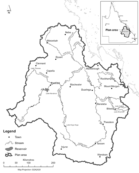
sch 1 sub 2021 SL No. 71 s 45
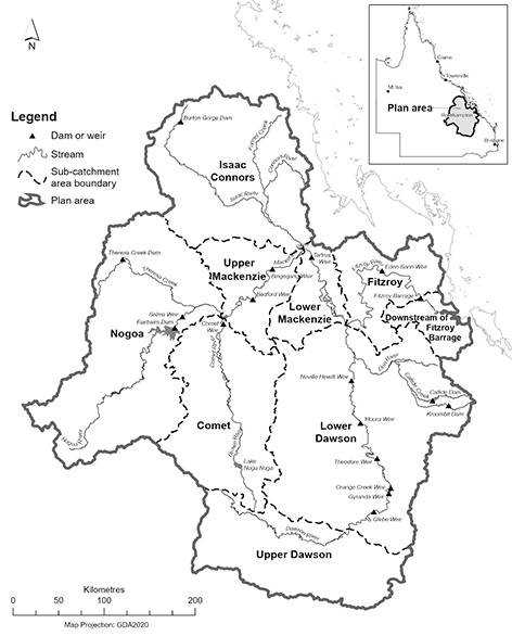
sch 2 sub 2021 SL No. 71 s 45
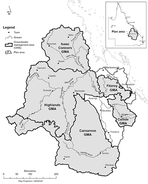
sch 3 sub 2021 SL No. 71 s 45
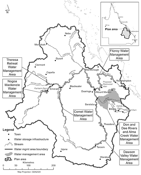
sch 3A ins 2015 SL No. 121 s 24
sub 2021 SL No. 71 s 45
Map A—Water management area zones for Comet, Nogoa Mackenzie and Theresa Retreat water management areas
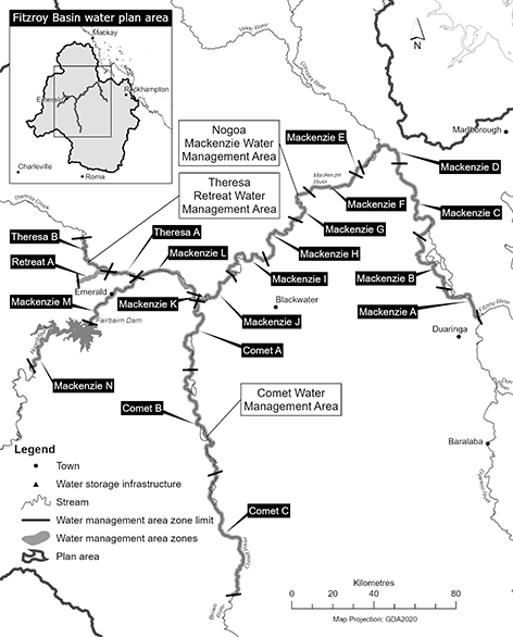
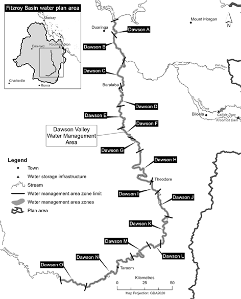
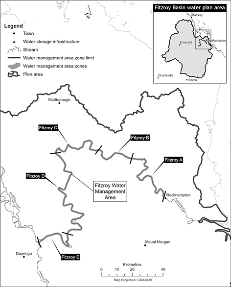
sch 3B ins 2021 SL No. 71 s 45
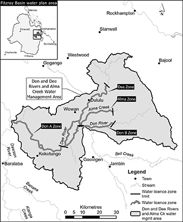
sch 3C ins 2021 SL No. 71 s 45
section 7(2)–(2D)
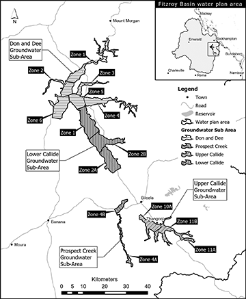
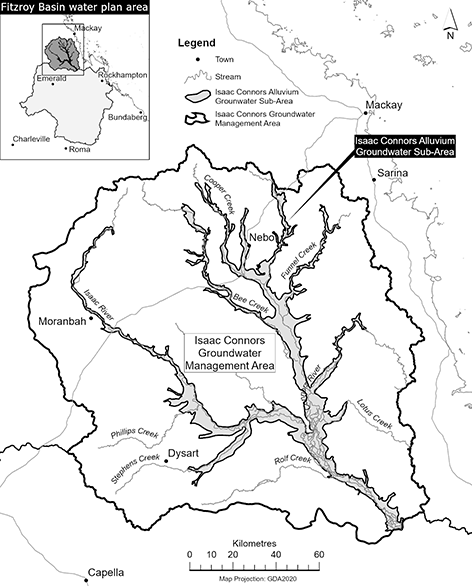
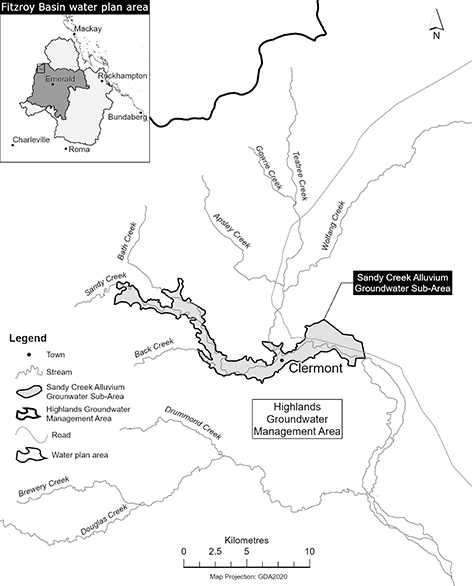
sch 4 sub 2021 SL No. 71 s 45
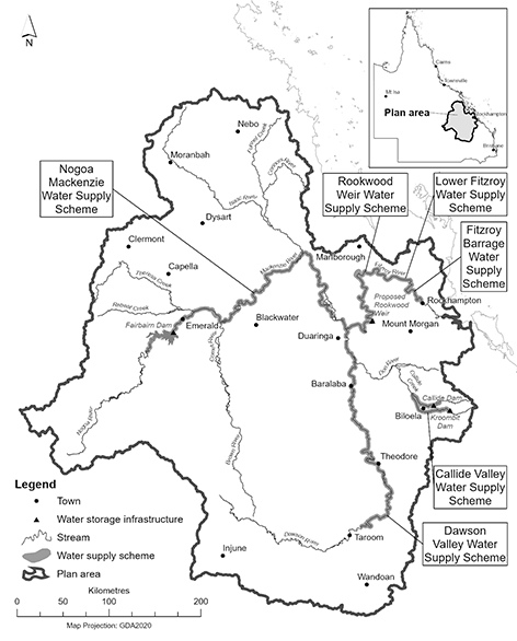
sch 4A ins 2021 SL No. 71 s 45
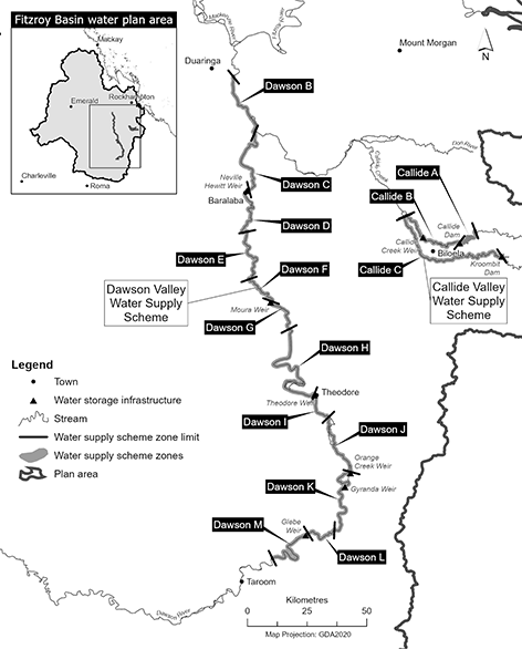
Map B—Water supply scheme zones for Fitzroy Barrage, Lower Fitzroy and Rookwood Weir water supply schemes
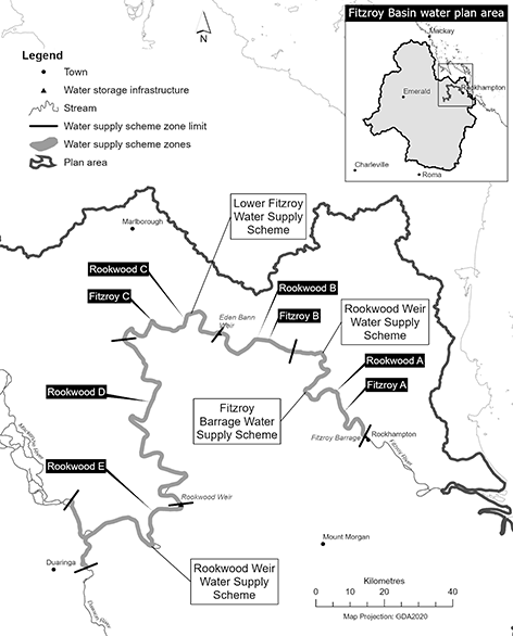
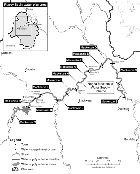
sch 4B ins 2021 SL No. 71 s 45
section 9(2)
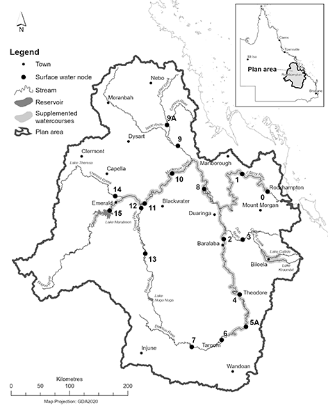
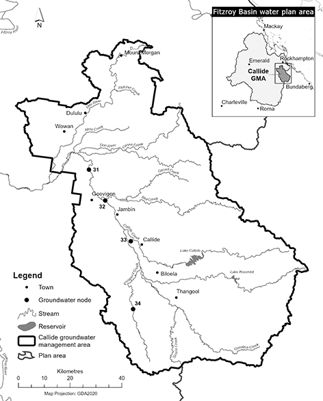
Column 1 | Column 2 |
Node | Location |
Node 0 | Fitzroy River at Fitzroy Barrage (AMTD 59.6km) |
Node 1 | Fitzroy River immediately downstream of Eden Bann Weir (AMTD 141.2km) |
Node 2 | Dawson River at Beckers (AMTD 71.0km) |
Node 3 | Don River at Rannes (AMTD 44.4km) |
Node 4 | Dawson River immediately downstream of Theodore Weir (AMTD 228.5km) |
Node 5A | Dawson River at Nathan Gorge (AMTD 307.2km) |
Node 6 | Dawson River at Taroom (AMTD 384.6km) |
Node 7 | Dawson River at Utopia Downs (AMTD 453.5km) |
Node 8 | Mackenzie River at Coolmaringa (AMTD 376.0km) |
Node 9 | Isaac River at Yatton (AMTD 43.0km) |
Node 9A | Connors River at Pink Lagoon (AMTD 46.8km) |
Node 10 | Mackenzie River immediately downstream of Bingegang Weir (AMTD 489.2km) |
Node 11 | Mackenzie River at Rileys Crossing (AMTD 601.4km) |
Node 12 | Comet River immediately downstream of Comet Weir (AMTD 10.8km) |
Node 13 | Comet River at The Lake (AMTD 124.2km) |
Node 14 | Theresa Creek at Main Road (AMTD 14.5km) |
Node 15 | Nogoa River immediately downstream of Fairbairn Dam (AMTD 685.6km) |
Column 1 | Column 2 |
Node | Location |
31 | Downstream part of Callide Valley |
32 | Confluence of Bell Creek and Callide Creek |
33 | Downstream section of supplemented area |
34 | Prospect Creek |
sch 5 amd 2021 SL No. 71 s 46
sections 16, 17, 19 and 23 and schedule 13, definition base flow
At each node mentioned in table 1, column 1—(a)for watercourses within water supply schemes—the percentage of the total number of days in a water flow season in the simulation period that the base flow, for the node, in table 1, column 2, is equalled or exceeded should be between 0.8 and 1.2 times the percentage stated for the water flow season for the node, in table 1, column 3; and
(b)for watercourses elsewhere—the percentage of the total number of days in a water flow season in the simulation period that the base flow, for the node, in table 1, column 2, is equalled or exceeded is to be at least 0.9 times the percentage stated for the water flow season for the node, in table 1, column 3.
Table 1
Column 1 | Column 2 | Column 3 | ||
Node | Base flow (ML/d) | Water flow season | ||
January–April water flow season | May–August water flow season | September– December water flow season | ||
0 | 288 | 88% | 57% | 47% |
2 | 86 | 64% | 27% | 35% |
3 | 26 | 45% | 22% | 21% |
6 | 38 | 51% | 26% | 30% |
8 | 190 | 82% | 41% | 37% |
9 | 104 | 84% | 49% | 33% |
9A | 90 | 87% | 58% | 37% |
10 | 163 | 54% | 19% | 29% |
12 | 148 | 33% | 10% | 11% |
14 | 104 | 23% | 5% | 8% |
Column 1 Column 2 Column 3 Column 4 Column 5 Node Mean annual flow Median annual flow ratio Annual proportional flow deviation Mean wet season flow 0 77% 58% 2.5 80% 2 65% 48% 3.1 Not applicable 3 85% 85% 1.1 6 90% 85% 0.5 8 80% 65% 2 9 90% 80% 1.2 9A 90% 85% 1.2 10 70% 50% 3 12 80% 54% 2 14 90% 75% 11At each node mentioned in table 2, column 1—
(a)the mean annual flow in the simulation period, expressed as a percentage of the mean annual flow for the pre-development flow pattern, is to be at least the percentage stated for the node in table 2, column 2; and
(b)the median annual flow ratio in the simulation period, expressed as a percentage, is to be at least the percentage stated for the node in table 2, column 3; and
(c)the annual proportional flow deviation is to be not more than the annual proportional flow deviation stated for the node in table 2, column 4; and
(d)the mean wet season flow in the simulation period, expressed as a percentage of the mean wet season flow for the pre-development flow pattern, is to be at least the percentage stated for the node in table 2, column 5.
Table 2
2At each node mentioned in table 3, column 1—(a)the 10% daily exceedance duration flow in the simulation period, expressed as a percentage of the 10% daily exceedance duration flow for the pre-development flow pattern, is to be at least the percentage stated for the node in table 3, column 2; and(b)the 4% daily exceedance duration flow in the simulation period, expressed as a percentage of the 4% daily exceedance duration flow for the pre-development flow pattern, is to be at least the percentage stated for the node in table 3, column 3; and(c)the 2 year daily flow volume in the simulation period, expressed as a percentage of the 2 year daily flow volume for the pre-development flow pattern, is to be at least the percentage stated for the node in table 3, column 4; and(d)the 5 year daily flow volume in the simulation period, expressed as a percentage of the 5 year daily flow volume for the pre-development flow pattern, is to be at least the percentage stated for the node in table 3, column 5; and(e)the 20 year daily flow volume in the simulation period, expressed as a percentage of the 20 year daily flow volume for the pre-development flow pattern, is to be at least the percentage stated for the node in table 3, column 6.Table 3
Column 1
Column 2
Column 3
Column 4
Column 5
Column 6
Node
10% daily exceedance duration flow
4% daily exceedance duration flow
2 year daily flow volume
5 year daily flow volume
20 year daily flow volume
0
55%
74%
75%
87%
88%
2
45%
53%
55%
69%
80%
3
82%
81%
86%
89%
90%
6
81%
81%
91%
97%
98%
8
57%
74%
86%
91%
97%
9
80%
82%
80%
94%
92%
9A
83%
87%
74%
94%
90%
10
45%
59%
62%
72%
84%
12
45%
61%
60%
78%
98%
14
82%
71%
78%
93%
98%
The performance indicators for the first post-winter flow event objective are the following—(a)the number of first post-winter flow events in the simulation period expressed as a percentage of the number of post-winter flow years in the period;(b)the number of 5-week lag events in the simulation period, expressed as a percentage of the number of post-winter flow years in the period;(c)the number of 2-week lag events in the simulation period, expressed as a percentage of the number of 5-week lag events in the period;(d)the average of the volume ratios for the post-winter flow years in the simulation period;(e)the average of the peak flow ratios for the post-winter flow years in the simulation period;(f)the number of 2-times base flow events in the simulation period, expressed as a percentage of the number of post-winter flow years in the period;(g)the number of 5-times base flow events in the simulation period, expressed as a percentage of the number of post-winter flow years in the period.
2First post-winter flow event objectives
The first post-winter flow event objectives are—(a)first post-winter flow events that pass through dams, weirs, barrages, watercourses or lakes are to mimic the pre-development flow pattern of first post-winter flow events in duration, timing and magnitude; and(b)for each node mentioned in table 4, column 1—(i)the performance indicator mentioned in item 1(a) is to be at least the percentage stated for the node in table 4, column 2; and(ii)the performance indicator mentioned in item 1(b) is to be at least the percentage stated for the node in table 4, column 3; and(iii)the performance indicator mentioned in item 1(c) is to be at least the percentage stated for the node in table 4, column 4; and(iv)the performance indicator mentioned in item 1(d) is to be at least the percentage stated for the node in table 4, column 5; and(v)the performance indicator mentioned in item 1(e) is to be at least the percentage stated for the node in table 4, column 6; and(vi)the performance indicator mentioned in item 1(f) is to be at least the percentage stated for the node in table 4, column 7; and(vii)the performance indicator mentioned in item 1(g) is to be at least the percentage stated for the node in table 4, column 8.Table 4
Column 1
Column 2
Column 3
Column 4
Column 5
Column 6
Column 7
Column 8
Node
Number of first post- winter flows
Number of flows within 5 weeks of the pre- develop- ment event
Number of flows within 2 weeks of the pre- develop- ment event
Average flow volume
Average peak flow
Flow duration (2-times base flow)
Flow duration (5-times base flow)
0
80%
60%
70%
70%
Not applicable
70%
70%
2
80%
60%
70%
Not applicable
60%
60%
60%
3
90%
80%
90%
Not applicable
80%
90%
90%
6
90%
90%
90%
Not applicable
90%
90%
90%
8
90%
70%
70%
Not applicable
80%
80%
80%
9
90%
80%
80%
Not applicable
80%
80%
70%
9A
90%
90%
90%
Not applicable
90%
90%
90%
10
70%
50%
70%
Not applicable
60%
60%
60%
12
90%
80%
80%
Not applicable
80%
80%
50%
14
90%
80%
80%
Not applicable
80%
80%
80%
3Definitions for pt 3
In this part—For each node mentioned in table 5, column 1, the drawdown duration for the corresponding specified height in column 2 is not less than the corresponding percentage in column 3.2-times base flow event means a post-winter flow year in which the days of flow twice base flow are not more than 4 days fewer than the days of flow twice base flow in the year for the pre-development flow pattern.2-week lag event means a first post-winter flow event that starts within 2 weeks of the date the first post-winter flow event starts in the same year for the pre-development flow pattern.5-times base flow event means a post-winter flow year in which the days of flow 5-times base flow are not more than 4 days fewer than the days of flow 5-times base flow in the year for the pre-development flow pattern.5-week lag event means a first post-winter flow event that starts within 5 weeks of the date the first post-winter flow event starts in the same year for the pre-development flow pattern.daily flow means the volume of water that flows past a node in a day.days of flow 5-times base flow means the number of days in a first post-winter flow event on which the daily flow is at least 5 times the base flow.days of flow twice base flow means the number of days in a first post-winter flow event on which the daily flow is at least twice the base flow.event volume—1Event volume means the total daily flows for a first post-winter flow event.2However, if the event volume calculated under paragraph 1 is greater than the volume of the estuary of the Fitzroy River, the event volume is the estuary volume.first peak flow—1First peak flow means the daily flow on the first day in a first post-winter flow event on which the flow reaches a peak.2However, if the first peak flow calculated under paragraph 1 is greater than the daily flow for a flow with a nominal depth of 3m (a 3-metre event), the first peak flow is the daily flow for a 3-metre event.first post-winter flow event—1First post-winter flow event, at a node, means the first flow in a year that—(a)starts between 15 September and 10 April in the year; and(b)either—(i)for node 9A—lasts for 18 days; or(ii)for another node—lasts for 21 days; or(c)the chief executive is satisfied meets the following criteria—(i)for node 0—(A)the flow at its start is at least 5,000ML a day; and(B)the event has an event volume greater than half the volume of the estuary of the Fitzroy River;(ii)for another node—(A)the flow, within 6 days after its start, is greater than a flow with a nominal depth of 1.5m; and(B)the first peak in the flow that is greater than a flow with a nominal depth of 1.5m happens within 6 days after the start of the event;(iii)if the flow starts in September, the water temperature is at least 24ºC;(iv)for the duration of the event the flow, at the node, is greater than the base flow for the node mentioned in table 1, column 2.2However, a first post-winter flow event does not include a flow that happens in a year in the simulation period for which a flow satisfying the requirements of paragraph 1 did not happen for the pre-development flow pattern.peak flow ratio means the first peak flow for a year expressed as a percentage of the first peak flow for the year for the pre-development flow pattern where the ratio is less than or equal to 1.post-winter flow year means a year in the simulation period in which a first post-winter flow event happens for the pre-development flow pattern.volume ratio means the event volume for a year, expressed as a percentage of the event volume for the year for the pre-development flow pattern, where the ratio is less than or equal to 1.year means a period of 12 months beginning on 1 July.
Table 5
Column 1 | Column 2 | Column 3 |
Node | Specified height above June 2007 level (metres) | Percentage |
31 | 2 | 75 |
32 | 2 | 60 |
33 | 3 | 75 |
34 | 0 | 75 |
sch 6 amd 2015 SL No. 121 s 25
sections 21 and 23
1Callide Valley Water Supply Scheme
1For water allocations in the high A priority group—(a)the annual supplemented water sharing index is to be at least 95%; and(b)the monthly supplemented water sharing index is to be at least 98%.2For water allocations in the high B priority group—the annual supplemented water sharing index is to be at least 90%.3For water allocations in the risk priority group—the annual supplemented water sharing index is to be at least 60%.4For water allocations in the medium priority group—the annual supplemented water sharing index is to be at least 65%.
2Dawson Valley Water Supply Scheme
1For water allocations in the high priority group—(a)the annual supplemented water sharing index is to be at least 95%; and(b)the monthly supplemented water sharing index is to be at least 98%.2For water allocations in the medium priority group—the monthly supplemented water sharing index is to be at least 82%.3For water allocations in the medium A priority group—the monthly supplemented water sharing index is to be at least 82%.
3Lower Fitzroy Water Supply Scheme and Fitzroy Barrage Water Supply Scheme
1For water allocations in the high priority group—(a)the annual supplemented water sharing index is to be at least 94%; and(b)the monthly supplemented water sharing index is to be at least 98%.2For water allocations in the medium priority group—the monthly supplemented water sharing index is to be at least 82%.
3ARookwood Weir Water Supply Scheme
1For water allocations in the high priority group—(a)the annual supplemented water sharing index is to be at least 94%; and(b)the monthly supplemented water sharing index is to be at least 98%.2For water allocations in the medium priority group—the monthly supplemented water sharing index is to be at least 82%.sch 7 s 3A ins 2021 SL No. 71 s 47
amd 2022 SL No. 119 s 3
4Nogoa Mackenzie Water Supply Scheme
For water allocations in a water allocation group mentioned in table 1, column 1, the annual volume probability is to be at least the percentage stated for the group in table 1, column 2.1For water allocations in the high priority group—(a)the annual supplemented water sharing index is to be at least 95%; and(b)the monthly supplemented water sharing index is to be at least 98%.2For water allocations in the medium priority group—the monthly supplemented water sharing index is to be at least 82%.
Table 1
Column 1 | Column 2 |
Water allocation group | Annual volume probability |
Class 0A | 17% |
Class 1A | 73% |
Class 1B | 71% |
Class 2A | 47% |
Class 2B | 47% |
Class 3A | 38% |
Class 4C | 95% |
Class 5A | 61% |
Class 5B | 73% |
Class 6C | 95% |
Class 7D | 93% |
Class 8A | 45% |
Class 9A | 55% |
Class 9B | 47% |
Class 10A | 68% |
Class 10B | 68% |
Class 10C | 66% |
Class 11A | 63% |
Class 11B | 60% |
Class 12A | 63% |
Class 13A | 60% |
Class 13C | 67% |
5Lower Callide groundwater sub-area
1For water allocations in the GW1A water allocation group— the annual volume probability is to be at least 95%; and2For water allocations in the GW1B water allocation group— the annual volume probability is to be at least 65%.
sch 7 amd 2015 SL No. 121 s 26
sections 40 and 47
Column 1 | Column 2 | Column 3 |
Subcatchment area | State purpose nominal entitlement (ML) | Indigenous purpose nominal entitlement (ML) |
Isaac Connors | 15,000 | 5,000 |
Fitzroy | ||
Lower Mackenzie | ||
Upper Mackenzie | ||
Nogoa | ||
Upper Dawson | ||
Lower Dawson | ||
Comet | ||
Downstream of Fitzroy Barrage | 1,000 | 0 |
Column 1 | Column 2 |
Groundwater management area, unit or sub-area | Nominal entitlement (ML) |
Isaac Connors Alluvium groundwater sub-area | 450 |
Isaac Connors groundwater management area other than Isaac Connors Alluvium groundwater sub-area | 250 |
Callide Groundwater Unit 1 | 0 |
Callide Groundwater Unit 2 | 500 |
Sandy Creek Alluvium groundwater sub-area | 0 |
Highlands groundwater management area other than Sandy Creek Alluvium groundwater sub-area | 3,000 |
Fitzroy groundwater management area | 500 |
Carnarvon groundwater management area | 250 |
Column 1 | Column 2 |
Subcatchment area or part of subcatchment area | Mean annual diversion (ML) |
The Isaac Connors subcatchment area | 12,545 |
The Fitzroy subcatchment area | |
The Don and Dee Rivers and Alma Creek Water Management Area | |
The Lower Mackenzie subcatchment area | |
The Upper Mackenzie subcatchment area | 0 |
The Nogoa subcatchment area | 0 |
The Upper Dawson subcatchment area | 5,040 |
The Lower Dawson subcatchment area, other than the Don and Dee Rivers and Alma Creek Water Management Area | 0 |
The Comet subcatchment area | 0 |
Downstream of the Fitzroy Barrage subcatchment area | 0 |
Column 1 | Column 2 |
Subcatchment area | Nominal volume (ML) |
Isaac Connors | 0 |
Fitzroy | 7,000 |
Lower Mackenzie | 8,000 |
Upper Mackenzie | 0 |
Nogoa | 0 |
Upper Dawson | 0 |
Lower Dawson | 0 |
Comet | 0 |
Downstream of the Fitzroy Barrage | 0 |
Column 1 | Column 2 |
Groundwater management area, unit or sub-area | Nominal entitlement (ML) |
Isaac Connors Alluvium groundwater sub-area | 0 |
Isaac Connors groundwater management area other than Isaac Connors Alluvium groundwater sub-area | 750 |
Callide Groundwater Unit 1 | 0 |
Callide Groundwater Unit 2 | 500 |
Highlands groundwater management area—Sandy Creek Alluvium groundwater sub-area | 0 |
Highlands groundwater management area—groundwater management area other than Sandy Creek Alluvium groundwater sub-area | 6,579 |
Fitzroy Groundwater Unit 1 | 1,986 |
Fitzroy Groundwater Unit 2 | 2,000 |
Carnarvon groundwater management area | 820 |
sch 8 amd 2015 SL No. 121 s 27; 2021 SL No. 71 s 48
sections 95(1), 96(1), 104(1) and 105(1)
Column 1 | Column 2 | Column 3 |
Nominal pump size (mm) | Maximum rate (litres/second) | Daily volumetric limit (ML/day) |
32 | 11 | 0.6 |
40 | 15 | 1 |
50 | 35 | 1.5 |
65 | 60 | 2.6 |
80 | 80 | 3.9 |
100 | 110 | 5.6 |
125 | 140 | 7.8 |
150 | 165 | 9.9 |
200 | 215 | 16 |
250 | 275 | 21.6 |
300 | 340 | 25.9 |
350 | 415 | 30.2 |
400 | 500 | 37.2 |
500 | 780 | 56.2 |
600 to 660 | 1,400 | 95 |
750 | 2,375 | 160 |
800 | 2,900 | 201 |
sections 91(2) and 97
Column 1 | Column 2 | Column 3 | Column 4 |
Place | Flow condition | Water allocation group | Number of days |
Nogoa River from the upstream limit of Fairbairn Dam at AMTD 737.5km to its junction with Theresa Creek | 2,592ML/day | Class 0A | Not applicable |
Theresa Creek from its junction with Retreat Creek at AMTD 15.0km to its junction with the Nogoa River | more than 0ML/day | Class 8A | 24 |
Retreat Creek, including anabranches, from its junction with Kettle Creek at AMTD 23.6km to its junction with Theresa Creek | |||
Comet River, including anabranches, from Lake Brown gauging station AMTD 199.2km to its junction with the Nogoa River | less than 864ML/day | Class 9A | 24 |
equal to or more than 864ML/day | Class 9B | 20 | |
Dawson River from its junction with Mimosa Creek at AMTD 133km to its junction with the Mackenzie River, including sections of tributaries where Dawson River flows are accessible | 1,296ML/day | Class 10A | 20 |
2,592ML/day | Class 10B | 19 | |
Dawson River from the end of the supplemented section at AMTD 18.37km to its junction with the Mackenzie River, including sections of tributaries where Dawson River flows are accessible | 0 to 25ML/day | Class 10C | Not applicable |
Dawson River from Orange Creek Weir at AMTD 270.7km to its junction with Mimosa Creek at AMTD 133km, including sections of tributaries where Dawson River flows are accessible | 1,296ML/day | Class 11A | 20 |
2,592ML/day | Class 11B | 19 | |
Dawson River from the upstream limit of Glebe Weir at AMTD 356.5km to Orange Creek Weir at AMTD 270.7km, including sections of tributaries where Dawson River flows are accessible | 1,296ML/day | Class 12A | 20 |
Dawson River from Utopia Downs Gauging Station at AMTD 453.5km to the upstream limit of Glebe Weir at AMTD 356.5km, including sections of tributaries where Dawson River flows are accessible | up to 1,296ML/day | Class 13A | 20 |
up to 25ML/day | Class 13C | Not applicable |
schedule 13, definition annual proportional flow deviation

APFD means annual proportional flow deviation.
i means a particular month.
j means a particular year.
p means the number of years.
cij means the modelled flow for month i in year j.
nij means the modelled natural flow for month i in year j.
ni means the modelled natural flow for month i across p years
2 year daily flow volume, for a node, means the daily flow, at the node, that has a 50% probability of being reached at least once a year.
5 year daily flow volume, for a node, means the daily flow, at the node, that has a 20% probability of being reached at least once a year.
20 year daily flow volume, for a node, means the daily flow, at the node, that has a 5% probability of being reached at least once a year.
4% daily exceedance duration flow, for a node, means the daily flow that is equalled or exceeded on 4% of days in the simulation period.
10% daily exceedance duration flow, for a node, means the daily flow that is equalled or exceeded on 10% of days in the simulation period.
30% unsupplemented water sharing index, for a group of water allocations, means the total volume of water simulated to have been taken annually under the allocations in at least 30% of years in the simulation period, if the allocations were in existence for the whole of the simulation period, expressed as a percentage of the total of the nominal volumes for the allocations in the group for the allocations.
50% unsupplemented water sharing index, for a group of water allocations, means the total volume of water simulated to have been taken annually under the allocations in at least 50% of years in the simulation period, if the allocations were in existence for the whole of the simulation period, expressed as a percentage of the total of the nominal volumes for the allocations in the group for the allocations.
70% unsupplemented water sharing index, for a group of water allocations, means the total volume of water simulated to have been taken annually under the allocations in at least 70% of years in the simulation period, if the allocations were in existence for the whole of the simulation period, expressed as a percentage of the total of the nominal volumes for the allocations in the group for the allocations.
2010 authorisation ...
sch 13 def 2010 authorisation om 2021 SL No. 71 s 49(1)
2010 authorisation volume ...
sch 13 def 2010 authorisation volume om 2021 SL No. 71 s 49(1)
accounted use ...
sch 13 def accounted use om 2021 SL No. 71 s 49(1)
adopted middle thread distance means the distance in kilometres, measured along the middle of a watercourse, that a specific point in the watercourse is, at the commencement of this plan, from—
(a)the watercourse’s mouth; or
(b)if the watercourse is not a main watercourse—the watercourse’s confluence with its main watercourse.
amended water licence—
(a)for chapter 5, part 2, division 8, subdivision 2, see section 102; or
(b)for chapter 5, part 3, division 2, subdivision 2, see section 119.
amending authorisation ...
sch 13 def amending authorisation om 2021 SL No. 71 s 49(1)
AMTD means the adopted middle thread distance.
annual adjusted use volume ...
sch 13 def annual adjusted use volume om 2021 SL No. 71 s 49(1)
annual entitlement ...
sch 13 def annual entitlement amd 2016 SL No. 216 s 146 sch 20
om 2021 SL No. 71 s 49(1)
annual flow volume, for a node, means the total volume of flow, at the node, in a period of 12 months starting on 1 July.
annual proportional flow deviation, for a node, means the statistical measure of changes at the node to flow season and volume in the simulation period calculated using the formula in schedule 12.
annual supplemented water sharing index, for water allocations to take supplemented water in a particular priority group, means the percentage of years in the simulation period in which the allocations are fully supplied.
annual volume probability, for a water allocation group, means the percentage of years in the simulation period in which the volume of water that may be taken by the group is at least the total of the nominal volumes for the allocations in the group.
annual volumetric limit, for an interim water allocation or water allocation, means the maximum volume of water that may be taken under the allocation in a water year.
authorisation means a licence, permit, interim water allocation or other authority to take water given under the Act or the repealed Act, other than a permit for stock or domestic purposes.
base flow, for a node, means the flow stated for the node in schedule 6, part 1, table 1, column 2.
baseflow means the part of streamflow derived from the natural discharge of groundwater into a watercourse, lake or spring.
Braeside Borefield ...
sch 13 def Braeside Borefield reloc to s 28(3) 2021 SL No. 71 s 49(3)
Callide groundwater notification area ...
sch 13 def Callide groundwater notification area om 2021 SL No. 71 s 49(1)
Callide Valley groundwater computer program ...
sch 13 def Callide Valley groundwater computer program reloc to s 25(4) 2021 SL No. 71 s 49(4)
Callide Valley Water Supply Scheme means the scheme for the supply of water under the resource operations licence for the Callide Valley Water Supply Scheme.
sch 13 def Callide Valley Water Supply Scheme amd 2015 SL No. 121 s 28(3)
carry over ...
sch 13 def carry over om 2021 SL No. 71 s 49(1)
converted section 129 authorisation ...
sch 13 def converted section 129 authorisation ins 2015 SL No. 121 s 28(2)
om 2021 SL No. 71 s 49(1)
converting authorisation ...
sch 13 def converting authorisation om 2021 SL No. 71 s 49(1)
coordinated project means a project—
(a)declared under the State Development and Public Works Organisation Act 1971, section 26 to be a coordinated project; or
(b)taken, under section 190 of that Act, to be a coordinated project.
daily flow, for a node, means the volume of water, expressed in megalitres, that flows past the node in a day.
daily volumetric limit, for a water allocation, means the maximum volume of water that may be taken under the water allocation in a day.
Dawson Valley Water Supply Scheme is the scheme for the supply of water under the resource operations licence for the Dawson Valley Water Supply Scheme.
deemed use ...
sch 13 def deemed use om 2021 SL No. 71 s 49(1)
discharge, for a flow at a point in a watercourse, means the rate at which water passes the point, measured in cubic metres a second or megalitres a day.
Don and Dee Rivers and Alma Creek Water Management Area ...
sch 13 def Don and Dee Rivers and Alma Creek Water Management Area ins 2015 SL No. 121 s 28(2)
om 2021 SL No. 71 s 49(1)
drawdown duration means the percentage of days in the simulation period that the water level is above a specified height above the June 2007 level.
ecological assets ...
sch 13 def ecological assets reloc to s 14(2) 2021 SL No. 71 s 49(5)
enterprise means—
(a)for a water entitlement—any activity undertaken by the holder of the entitlement for the purpose stated on the entitlement, whether or not for commercial gain; or
(b)for the holder of a water entitlement—any activity undertaken by the holder for the purpose stated on the entitlement, whether or not for commercial gain.
enterprise infrastructure ...
sch 13 def enterprise infrastructure ins 2015 SL No. 121 s 28(2)
om 2021 SL No. 71 s 49(1)
existing groundwater works ...
sch 13 def existing groundwater works om 2021 SL No. 71 s 49(1)
existing overland flow works—
(a)means works that allow the taking of overland flow water and—(i)for an owner of land—were in existence on 13 September 2001; or(ii)for a lessee under a mining lease—were in existence before the commencement of this plan; and
(b)includes works that—(i)are a reconfiguration of existing overland flow works (the original works); and(ii)do not increase the average annual volume of water taken above the average annual volume taken using the original works.
Fitzroy Barrage Water Supply Scheme is the scheme for the supply of water under the resource operations licence for the Fitzroy Barrage Water Supply Scheme.
flow regime means the entire range of flows at a point in a watercourse including variations in the watercourse height, discharge, seasonality and annual variability.
forward draw ...
sch 13 def forward draw om 2021 SL No. 71 s 49(1)
groundwater means underground water to which the Water Plan (Great Artesian Basin and Other Regional Aquifers) 2017 does not apply.
sch 13 def groundwater amd 2016 SL No. 216 s 146 sch 20; 2017 SL No. 164 s 91
groundwater management area means a groundwater management area under section 6.
groundwater sub-area means a groundwater sub-area under section 7.
groundwater sub-area zone means a groundwater sub-area zone under section 7.
sch 13 def groundwater sub-area zone ins 2021 SL No. 71 s 49(2)
groundwater unit means a groundwater unit under section 7.
HOU consideration period ...
sch 13 def HOU consideration period om 2021 SL No. 71 s 49(1)
hydraulic habitat requirements ...
sch 13 def hydraulic habitat requirements om 2021 SL No. 71 s 49(1)
hyporheic zone ...
sch 13 def hyporheic zone reloc to s 27(3) 2021 SL No. 71 s 49(6)
Indigenous purpose means a use for the purpose of helping an Indigenous community achieve its economic and social aspirations.
IQQM computer program means the department’s Integrated Quantity and Quality Modelling computer program, and associated statistical analysis and reporting programs, that simulate daily stream flows, flow management, storages, releases, instream infrastructure, water diversions, water demands and other hydrologic events in the plan area.
Isaac Connors groundwater notification area ...
sch 13 def Isaac Connors groundwater notification area om 2021 SL No. 71 s 49(1)
June 2007 level means the actual water level on 30 June 2007.
Lower Fitzroy Water Supply Scheme is the scheme for the supply of water under the resource operations licence for the Lower Fitzroy Water Supply Scheme.
mean annual flow, for a node, means the total volume of flow, at the node, in the simulation period divided by the number of years in the simulation period.
mean wet season flow, for a node, means the total volume of flow during the months of January, February, March and April in the simulation period divided by the number of years in the simulation period.
median annual flow ratio, for a node, means the ratio of the annual flow volume in the simulation period to the corresponding annual flow volume for the pre-development flow pattern that is equalled or exceeded in 50% of years in the simulation period.
mine dewatering ...
sch 13 def mine dewatering reloc to s 118(3) 2021 SL No. 71 s 49(7)
modern coastal deposits ...
sch 13 def modern coastal deposits reloc to s 7(8) 2021 SL No. 71 s 49(8)
monthly supplemented water sharing index, for water allocations to take supplemented surface water in a particular priority group, means the percentage of months in the simulation period in which the allocations are fully supplied.
node see section 9.
Nogoa Mackenzie Water Supply Scheme is the scheme for the supply of water under the resource operations licence for the Nogoa Mackenzie Water Supply Scheme.
nominal entitlement—
(a)for a water licence—see the Water Regulation 2016, section 28; or
(b)for an interim water allocation—means the volume stated on the interim water allocation that may be taken in a 12-month period.
sch 13 def nominal entitlement amd 2016 SL No. 216 s 146 sch 20
plan area see section 4.
potential productive capacity ...
sch 13 def potential productive capacity ins 2015 SL No. 121 s 28(2)
om 2021 SL No. 71 s 49(1)
pre-2010 contributing authorisation ...
sch 13 def pre-2010 contributing authorisation om 2021 SL No. 71 s 49(1)
pre-conversion use volume ...
sch 13 def pre-conversion use volume ins 2015 SL No. 121 s 28(2)
om 2021 SL No. 71 s 49(1)
pre-development flow pattern means the pattern of water flows, during the simulation period, decided by the chief executive using the IQQM computer program as if—
(a)there were no dams or other water infrastructure in the plan area; and
(b)no water was taken under authorisations in the plan area.
prescribed authorisation ...
sch 13 def prescribed authorisation om 2021 SL No. 71 s 49(1)
prescribed existing groundwater works ...
sch 13 def prescribed existing groundwater works om 2021 SL No. 71 s 49(1)
previous authorisation ...
sch 13 def previous authorisation om 2021 SL No. 71 s 49(1)
previous plan ...
sch 13 def previous plan reloc to s 111(5) 2021 SL No. 71 s 49(9)
previous section 51 ...
om 2021 SL No. 71 s 49(1)
project of regional significance means a project the chief executive considers to be a project of regional significance under section 42.
sch 13 def project of regional significance ins 2015 SL No. 121 s 28(2)
project of State significance ...
sch 13 def project of State significance om 2015 SL No. 121 s 28(1)
quaternary alluvium ...
sch 13 def quaternary alluvium reloc to s 7(8) 2021 SL No. 71 s 49(8)
refugia ...
sch 13 def refugia reloc to s 14(2) 2021 SL No. 71 s 49(5)
relevant groundwater-dependent ecosystem means a groundwater-dependent ecosystem that is a riparian vegetation ecosystem or terrestrial vegetation ecosystem.
resource operations plan means the resource operations plan to implement this plan.
See the Act, section 1266.
sch 13 def resource operations plan amd 2016 SL No. 216 s 146 sch 20
riparian vegetation ecosystem means a vegetation ecosystem that includes groundwater-dependent vegetation growing on, or immediately adjacent to, the banks of a lagoon or stream in the plan area.
Rookwood Weir Water Supply Scheme is the scheme for the supply of water under the resource operations licence for the Rookwood Weir Water Supply Scheme.
sch 13 def Rookwood Weir Water Supply Scheme ins 2021 SL No. 71 s 49(2)
seasonality, in relation to the flow in a watercourse, means the time of year when the flow happens.
section 129 authorisation ...
sch 13 def section 129 authorisation ins 2015 SL No. 121 s 28(2)
om 2021 SL No. 71 s 49(1)
section 137(c) allocation ...
sch 13 def section 137(c) allocation ins 2015 SL No. 121 s 28(2)
om 2021 SL No. 71 s 49(1)
simulated mean annual diversion ...
sch 13 def simulated mean annual diversion reloc to s 94(2) 2021 SL No. 71 s 49(10)
simulation period means the period from 1 January 1900 to 31 December 2007.
State purpose means—
(a)a coordinated project; or
(b)a project of regional significance; or
(c)town water supply purposes; or
(d)use by Indigenous peoples for non-commercial purposes, including cultural and traditional purposes.
subcatchment area see section 5.
supplemented water means water supplied under an interim resource operations licence, resource operations licence or other authority to operate water infrastructure.
surface water see section 10(1).
terrestrial vegetation ecosystem means a vegetation ecosystem, other than a riparian vegetation ecosystem.
this plan ...
sch 13 def this plan om 2021 SL No. 71 s 49(1)
traditional owners, of an area, means the Aboriginal people who identify as descendants of the original inhabitants of the area.
unallocated water means water available for allocation in the plan area.
unsupplemented water means water that is not supplemented water.
unsupplemented water allocation means a water allocation to take unsupplemented water.
volume density ...
sch 13 def volume density reloc to s 29(4) 2021 SL No. 71 s 49(11)
water accounts ...
sch 13 def water accounts om 2021 SL No. 71 s 49(1)
water bore ...
sch 13 def water bore reloc to s 27(3) 2021 SL No. 71 s 49(6)
water flow season means any of the following periods in a year—
(a)the period from 1 January to 30 April (January–April water flow season);
(b)the period from 1 May to 31 August (May–August water flow season);
(c)the period from 1 September to 31 December (September–December water flow season).
waterhole means a part of a watercourse that contains water after the watercourse ceases to flow, other than a part of a watercourse that is within the storage area of a dam on the watercourse.
water licence zone see section 7C.
sch 13 def water licence zone ins 2021 SL No. 71 s 49(2)
water management area see section 7A.
sch 13 def water management area ins 2021 SL No. 71 s 49(2)
water management area zone means a water management area zone under section 7B.
sch 13 def water management area zone ins 2021 SL No. 71 s 49(2)
water supply scheme see section 7D.
sch 13 def water supply scheme ins 2021 SL No. 71 s 49(2)
water supply scheme zone means a water supply scheme zone under section 7E.
sch 13 def water supply scheme zone ins 2021 SL No. 71 s 49(2)
water year ...
sch 13 def water year om 2021 SL No. 71 s 49(1)
works that allow the taking of overland flow water include—
(a)storages, sumps, drains, embankments, channels and pumps for taking, or that can be used for taking, overland flow water; and
(b)storages that are connected to the works mentioned in paragraph (a); and
(c)works that make, or that can be used to make, the original connection between the storages mentioned in paragraph (b) and the works mentioned in paragraph (a).