


This declaration may be cited as the Fisheries Declaration 2019.
This declaration commences on 28 May 2019.
(1)The dictionary in schedule 5 defines particular words used in this declaration.(2)A reference in this declaration to particular regulated waters by name or description is a reference to the regulated waters with that name or description under schedule 1.(3)Subject to subsections (1) and (2), and unless this declaration provides otherwise, terms used in it have the meaning given under the Fisheries (General) Regulation 2019.(4)Subsection (3) is not limited to a term defined under the Fisheries (General) Regulation 2019 but also applies to a provision of the regulation that aids the interpretation of a term mentioned in the regulation.See, for example—(a)sections 14 and 15 of the regulation for the interpretation of references to periods and times; and(b)schedule 7 of the regulation for the interpretation of references to, or relating to, fish; and(c)schedule 8 of the regulation for the interpretation of references to, or relating to, waters or areas; and(d)schedule 9 of the regulation for the interpretation of references to, or relating to, boats; and(e)schedule 10 of the regulation for the interpretation of references to, or relating to, fishing apparatus.s 3 amd 2019 SL No. 181 s 4
4Relationship between fisheries declarations
(1)If an activity is prohibited under a fisheries declaration, the activity is prohibited even if the activity is not prohibited, or is not prohibited in the same way, under another fisheries declaration, whether of the same type or another type.(2)If 2 or more fisheries declarations, whether of the same type or different types, apply to the carrying out of an activity, both or all of the fisheries declarations must be complied with in relation to the carrying out of the activity.1Under a regulated waters declaration, a person must not in the northern rocklobster waters take a tropical rocklobster in the regulated period from 1 October to 31 December or possess a tropical rocklobster taken in the waters in that period. Under a regulated fish declaration, a recreational fisher may take or possess a maximum of 5 tropical rocklobsters. A recreational fisher must not take tropical rocklobsters in the northern rocklobster waters between 1 October and 31 December, or possess tropical rocklobsters taken in the waters in that period, even though the recreational fisher could take or possess up to a maximum of 5 tropical rocklobsters under the regulated fish declaration.2Under a regulated fish declaration, a recreational fisher may take a maximum of 8 redthroat emperor. Under another regulated fish declaration, a recreational fisher may take a maximum of 20 regulated coral reef fin fish. A recreational fisher takes 17 regulated coral reef fin fish, consisting of 7 regulated coral trout and 10 hussar, and intends to take redthroat emperor. To comply with both declarations, the recreational fisher may take a maximum of 3 redthroat emperor.s 4 amd 2019 SL No. 181 s 5; 2020 SL No. 236 s 39
5References to taking a particular quantity of fish
For a fisheries declaration, a person takes a particular quantity of fish only if, at any given time, the person possesses that quantity of fish that the person has taken.
(1)This chapter provides for regulated waters declarations under sections 33 and 35 of the Act.(2)Part 2 declares particular waters to be regulated waters.(3)Parts 3 to 13 regulate the carrying out of particular activities in the regulated waters.
7Activity regulated in stated period
(1)This section applies if a regulated waters declaration states a period in which an activity is regulated in stated regulated waters.(2)The activity is regulated in the stated regulated waters under the regulated waters declaration only in the stated period.
8Activity regulated at all times if no period stated
(1)This section applies if—(a)an activity is regulated in stated regulated waters under a regulated waters declaration; and(b)the declaration does not state a particular period in which the activity is regulated in the waters.(2)The activity is regulated in the regulated waters at all times.
9Fisheries regulated waters plans
(1)The chief executive may prepare a fisheries regulated waters plan for this chapter.(2)A fisheries regulated water plan is—(a)held by the chief executive; and(b)identified by the prefix ‘FRW’ followed by the plan number.‘FRW-303’(3)Copies of fisheries regulated waters plans are—(a)available for inspection, free of charge, during office hours on business days at the department’s head office; and(b)published on the department’s website.
10Particular waters declared as regulated waters
(1)Each of the waters described in schedule 1, column 2—(a)is declared to be regulated waters; and(b)has the name set out opposite it in column 1 of the schedule.(2)The regulated waters in schedule 1, part 1 are named by reference to particular fish, the taking or possession of which is regulated in the waters.(3)The regulated waters in schedule 1, part 2 are—(a)named by reference to their location; and(b)listed in approximate order of their location going from the State’s border with New South Wales to the State’s border with the Northern Territory.1To help users of this declaration, indicative plans of particular regulated waters are published on the department’s website.2The indicative plans are not applied, adopted or incorporated by this declaration.
11Regulated waters shown on a fisheries regulated waters plan
(1)This section applies for identifying waters that form part of regulated waters that are declared by reference to waters shown as regulated waters on a fisheries regulated waters plan.(2)Waters shown within the boundary lines on the fisheries regulated waters plan are part of the regulated waters.(3)However, if the fisheries regulated waters plan shows that waters within a particular boundary are excluded from the regulated waters shown on the plan, those waters are not part of the regulated waters.(4)If the fisheries regulated waters plan shows a boundary by reference to a geographical feature or fixed structure—(a)the boundary is decided by reference to the feature or structure; and(b)to the extent the boundary is decided by reference to the feature or structure, a line in relation to the boundary shown on the plan is only indicative of the current position of the boundary.Regulated waters are shown on a fisheries regulated waters plan by reference to a shoreline. Rough weather alters the location of parts of the shoreline. The boundary of the regulated waters is decided by reference to the shoreline as altered, despite any inconsistency with the location of the shoreline as shown on the plan.(5)Also, if the fisheries regulated waters plan shows a boundary with a gap in it, the boundary continues in a straight line across the gap to the nearest point of the boundary on the other side of the gap.
(1)A person must not carry out an activity in regulated waters that is prohibited under parts 4 to 12.The provisions under which activities in particular regulated waters are regulated are stated opposite the waters in schedule 1, column 3.(2)Subsection (1) does not apply to a person carrying out an activity that is permitted under part 13.
13Regulated waters to which division applies
This division applies to the following regulated waters—•Flat Rock (grey nurse shark protection area)•Cherub’s Cave (grey nurse shark protection area)•Henderson Rock (grey nurse shark protection area).
A person must not in the regulated waters—(a)take any fish; or(b)possess a fish taken in contravention of paragraph (a).
15Exception for taking fish by hand, scoop net or seine net
Despite section 14, a person may take a fish in the regulated waters if the person takes the fish—(a)under an A1 or A2 licence; and(b)by hand or using a scoop net or seine net; and(c)from 6a.m. to 6p.m. on a particular day.s 15 amd 2020 SL No. 236 s 82 sch 1
16Exception for taking spanner crabs
(1)Despite section 14, a person may take a spanner crab in the regulated waters if the person takes the crab—(a)under a C2 licence; and(b)from 6a.m. to 6p.m. on a particular day.(2)Despite section 14, a recreational fisher may take a spanner crab in the regulated waters if the fisher—(a)does not use fishing apparatus, other than a prescribed dilly, to take the crab; and(b)uses no more than 4 prescribed dillies to take the crab.(3)In this section—prescribed dilly means a dilly that has—(a)an area within its frame of no more than 1m2; and(b)a net drop below its frame of no more than 10cm; and(c)a net made up of square or rectangular meshes with a mesh size of at least 25mm; and(d)the following attached to it—(i)a tag on which is written, legibly, visibly and in English, the full name and address of the person using the dilly;(ii)a solid, light-coloured float that is no less than 15cm in any dimension and on which the name of the person using the dilly is also written, legibly, visibly and in English.s 16 amd 2019 SL No. 181 s 6; 2020 SL No. 236 ss 40, 82sch 1
17Regulated waters to which division applies
(1)This division applies to the following regulated waters—•Mission Bay•Torres Strait near Hammond Island•South Mitchell River.(2)This division also applies to the following regulated waters—•Coombabah Lake and Coombabah Creek•Swan Bay•Wolf Rock (grey nurse shark protection area)•Tinana Creek Barrage•Tinana Creek (upstream)•Mary River Barrage•Burnett River Barrage•Kolan River Barrage•Fitzroy River Barrage•Keppel Bay (fishing)•Dalrymple Bay and Hay Point•Hook Island (fishing)•Yanks Jetty at Orpheus Island•Centenary Lakes, Cairns•Barron River (fishing)•Bizant River, Princess Charlotte Bay.s 17 amd 2019 SL No. 181 s 7; 2020 SL No. 236 s 41
A person must not in the regulated waters—(a)take any fish; or(b)possess a fish taken in contravention of paragraph (a).See also the Fisheries (General) Regulation 2019, section 51 in relation to the issue of general purpose permits for the regulated waters mentioned in section 17(2).s 18 amd 2019 SL No. 181 s 27 sch 1
(1)Despite section 18, a person may take a juvenile eel in the following regulated waters if the person takes the eel under a JE licence—•Mary River Barrage•Burnett River Barrage•Kolan River Barrage•Fitzroy River Barrage.(2)In this section—juvenile eel means an elver or a glass eel.s 19 amd 2019 SL No. 181 s 27 sch 1; 2020 SL No. 236 s 82 sch 1
20Taking or possessing barramundi in regulated period—waters other than the Gulf of Carpentaria waters
(1)A person must not in the waters other than the Gulf of Carpentaria waters—(a)take barramundi in the regulated period; or(b)possess barramundi taken in contravention of paragraph (a).(2)For subsection (1)(a), the regulated period is from 1 November to 31 January.s 20 amd 2019 SL No. 181 s 8; 2020 SL No. 236 s 42
21Taking or possessing barramundi in regulated periods—Gulf of Carpentaria waters
(1)A person must not in the Gulf of Carpentaria waters—(a)take barramundi in the regulated taking period; or(b)possess barramundi taken in contravention of paragraph (a).(2)For subsection (1)(a), the regulated taking period is from 7 October to 31 January.(3)Also, a person must not in the Gulf of Carpentaria waters possess barramundi on a boat in the regulated possession period, whether or not the fish have been taken in the waters.(4)For subsection (3), the regulated possession period is from 17 October to 31 January.s 21 amd 2019 SL No. 181 s 8; 2020 SL No. 236 s 43
22Exception for recreational fishing
(1)Despite sections 20 and 21, a recreational fisher may—(a)take no more than 1 barramundi in a prescribed barramundi waterway within the regulated waters under section 20 or 21; or(b)possess a barramundi taken under paragraph (a).(2)However, subsection (1) applies only if the recreational fisher does not possess the barramundi while taking fish in the regulated waters, other than a prescribed barramundi waterway.
23Taking or possessing regulated coral reef fin fish in regulated periods—coral reef fin fish waters
(1)A person must not in the coral reef fin fish waters—(a)take a regulated coral reef fin fish in a regulated period; or(b)possess a regulated coral reef fin fish in a regulated period, whether or not the fish has been taken in the waters.(2)For subsection (1), each of the following periods is a regulated period—(a)from 25 October 2019 to 29 October 2019;(b)from 24 November 2019 to 28 November 2019;(c)from 14 October 2020 to 18 October 2020;(d)from 12 November 2020 to 16 November 2020;(e)from 3 October 2021 to 7 October 2021;(f)from 2 November 2021 to 6 November 2021;(g)from 22 October 2022 to 26 October 2022;(h)from 21 November 2022 to 25 November 2022;(i)from 12 October 2023 to 16 October 2023;(j)from 10 November 2023 to 14 November 2023.
24Exception for recreational fishing
Despite section 23(1)(b), a person may possess a regulated coral reef fin fish on a boat in the coral reef fin fish waters if—(a)the fish has not been taken in the waters in contravention of section 23(1)(a); and(b)either of the following applies—(i)the person is in possession of the fish for the purpose of consumption on the boat and the boat is not a commercial fishing boat and does not have a fishing line, spear or spear gun on board;(ii)the boat is being used for a charter fishing trip that has been conducted for an uninterrupted period of at least 24 hours.
25Exception for commercial fishing
(1)Despite section 23(1)(b), a person may possess a regulated coral reef fin fish on a boat in the coral reef fin fish waters if—(a)the fish has not been taken in the waters in contravention of section 23(1)(a); and(b)the fish has been taken under line units and is on an authorised boat for the holder of the line units; and(c)either—(i)the boat is at a relevant landing place or in a relevant defined port area; or(ii)the boat is not at a place or in an area mentioned in subparagraph (i) and it is during a permitted period.(2)In this section—authorised boat, for the holder of line units, see the Fisheries (Commercial Fisheries) Regulation 2019, schedule 6, section 15.permitted period means—(a)a period other than a regulated period mentioned in section 23(2); or(b)the period from the beginning of the first day of a regulated period mentioned in section 23(2) to 6p.m. on the day.relevant defined port area means the area of any of the following ports mentioned in the Transport Infrastructure (Ports) Regulation 2016, schedule 2—(a)Port of Abbot Point;(b)Port of Cairns;(c)Port of Cooktown;(d)Port of Gladstone;(e)Port of Mackay;(f)Port of Mourilyan;(g)Port of Townsville.relevant landing place, for an authorised boat for the holder of line units, means the place stated in a prior notice given under the Fisheries (Commercial Fisheries) Regulation 2019, schedule 6, part 5 as the place where the boat will be landed.s 25 amd 2019 SL No. 181 ss 9, 27 sch 1; 2020 SL No. 236 s 44
26Regulated waters to which division applies
This division applies to the following regulated waters—•Dumaresq River at Bonshaw Weir•Pike Creek at Glenlyon Dam•Barwon River at Mungindi Weir•Severn River at Queen Mine Waterhole•Quart Pot Creek at Storm King Dam•Balonne River at Beardmore Dam and Jack Taylor Weir•Macintyre River at Goondiwindi Weir•Macintyre Brook at Coolmunda Dam, Whetstone and Bendor weirs•Sandy Creek at Leslie Dam•Burnett Creek at Maroon Dam•Reynolds Creek at Moogerah Dam•Nerang River at Hinze Dam•Teviot Brook at Wyaralong Dam•Albert River at Luscombe Weir•Logan River at South Maclean and Cedar Grove weirs•Brisbane River at Old Mt Crosby Weir•Brisbane River at Mt Crosby Weir•Brisbane River at Wivenhoe Dam•North Pine River at North Pine Dam•Sideling Creek at Kurwongbah Dam•Balonne River at Surat Weir•Condamine River at Chinchilla, Loudon, Lemon Tree, Yarramalong, Cecil Plains and Reilly’s weirs•Dogwood Creek at Gil Weir (formerly Miles Weir)•Yabba Creek at Borumba Dam•Stuart River at Gordonbrook Dam•Six Mile Creek at Lake MacDonald•Boyne River (Auburn river basin) at Boondooma Dam•Dawson River at Glebe Weir•Dawson River at Gyranda Weir•Nogo River at Wuruma Dam•Dawson River at Theodore Weir•Burnett River at Paradise Dam, Claude Wharton, Ned Churchward and Kirar weirs•Three Moon Creek at Cania Dam•Dawson River at Moura Weir•Dawson River at Orange Creek Weir•Dawson River at Neville Hewitt Weir•Boyne River (Boyne river basin) at Awoonga Dam•Fitzroy River at Eden Bann Weir•Thomson River at Fairmount Weir•Fitzroy River at Wattlebank Control Weir•Nogoa River at Fairbairn Dam•Pioneer River at the Marian, Mirani and Dumbleton weirs•Burdekin River at Clare Weir.
27Taking or possessing freshwater fish
A person must not in the regulated waters—(a)take a freshwater fish; or(b)possess a freshwater fish taken in contravention of paragraph (a).
28Taking or possessing Australian bass in regulated period—regulated tidal waters
(1)A person must not—(a)take Australian bass in the regulated tidal waters in the regulated period; or(b)possess Australian bass taken in contravention of paragraph (a).(2)For subsection (1)(a), the regulated period is from 1 June to 31 August.
29Taking or possessing black jewfish—North Cape York
A person must not in the North Cape York regulated waters—(a)take a black jewfish; or(b)possess a black jewfish taken in contravention of paragraph (a).s 29 sub 2019 SL No. 181 s 10; 2020 SL No. 236 s 45
30Taking or possessing Craterocephalus—Thomson river basin
A person must not in the Thomson river basin regulated waters—(a)take a fish of the genus Craterocephalus; or(b)possess a fish of the genus Craterocephalus taken in contravention of paragraph (a).
31Taking or possessing fish other than fin fish—Fitzroy Island–High Island
A person must not in the Fitzroy Island–High Island regulated waters—(a)take any fish other than a fin fish; or(b)possess a fish taken in contravention of paragraph (a).
32Taking or possessing mud crabs—Eurimbula Creek
A person must not in the Eurimbula Creek regulated waters—(a)take a mud crab; or(b)possess a mud crab taken in contravention of paragraph (a).
33Taking or possessing Murray cod in regulated period—particular waters of the Murray–Darling drainage division
(1)A person must not in the particular waters of the Murray–Darling drainage division—(a)take a Murray cod in the regulated period; or(b)possess a Murray cod taken in contravention of paragraph (a).(2)For subsection (1)(a), the regulated period is from 1 August to 31 October.s 33 amd 2019 SL No. 181 s 11
34Taking or possessing pearl oysters—Darnley Island
A person must not in the Darnley Island regulated waters—(a)take a pearl oyster; or(b)possess a pearl oyster taken in contravention of paragraph (a).
35Taking or possessing snapper or pearl perch in regulated period—regulated tidal waters
(1)A person must not in the regulated tidal waters—(a)take a snapper or pearl perch in the regulated period; or(b)possess a snapper or pearl perch taken in contravention of paragraph (a).(2)For subsection (1)(a), the regulated period is from 15 July to 15 August.s 35 sub 2019 SL No. 181 s 12
36Taking or possessing spanner crabs in regulated period—spanner crab waters
(1)A person must not in the spanner crab waters—(a)take a spanner crab in the regulated period; or(b)possess a spanner crab taken in contravention of paragraph (a).(2)For subsection (1)(a), the regulated period is from 1 November to 15 December.
37Taking or possessing tropical rocklobsters in regulated period—northern rocklobster waters
(1)A person must not in the northern rocklobster waters—(a)take a tropical rocklobster in the regulated period; or(b)possess a tropical rocklobster taken in contravention of paragraph (a).(2)For subsection (1)(a), the regulated period is from 1 October to 31 December.s 37 amd 2020 SL No. 236 s 46
38Taking or possessing worms of the class Polychaeta—Wynnum (worm area)
A person must not in the Wynnum (worm area)—(a)take a worm belonging to the class Polychaeta; or(b)possess a worm taken in contravention of paragraph (a).
39Possessing or using fishing lines—Obi Obi Creek
A person must not in the Obi Obi Creek regulated waters—(a)possess a fishing line; or(b)use a fishing line to take a fish; or(c)possess a fish taken in contravention of paragraph (b).
39APossessing or using fishing lines in regulated period—particular regulated waters
(1)This section applies to the following regulated waters—•Coomera River (upstream)•Albert River (upstream)•Running Creek•Christmas Creek•Stanley River•Mary River (upstream).(2)A person must not in the regulated waters—(a)possess a fishing line in the regulated period; or(b)use a fishing line to take a fish in the regulated period; or(c)possess a fish taken in contravention of paragraph (b).(3)For subsection (2)(a) and (b), the regulated period is 1 August to 31 October.s 39A ins 2019 SL No. 181 s 13
40Possessing or using nets—Burnett River (netting) and Water Park Creek
(1)This section applies to the following regulated waters—•Burnett River (netting)•Water Park Creek.(2)A person must not in the regulated waters—(a)possess a net; or(b)use a net to take a fish; or(c)possess a fish taken in contravention of paragraph (b).
41Using shell dredges—particular regulated waters
(1)This section applies to the following regulated waters—•waterways, lakes and lagoons within the limits of the State•Moreton Bay (whole)•Hervey Bay and Great Sandy Strait (shell dredging)•Hinchinbrook Channel (fishing apparatus area 1).(2)A person must not in the regulated waters—(a)use a shell dredge to take a fish; or(b)possess a fish taken in contravention of paragraph (a).
42Taking or possessing great barracuda, pickhandle barracuda or spanish mackerel—Platypus Bay
A recreational fisher must not in the Platypus Bay regulated waters—(a)take a great barracuda, pickhandle barracuda or spanish mackerel; or(b)possess a fish taken in contravention of paragraph (a).
43Taking or possessing fin fish in regulated period—Fraser Island (Indian Head–Waddy Point)
(1)A recreational fisher must not in the Fraser Island (Indian Head–Waddy Point) regulated waters—(a)take a fin fish in the regulated period; or(b)possess a fin fish taken in contravention of paragraph (a).(2)For subsection (1)(a), the regulated period is from 1 August to 29 September.s 43 amd 2019 SL No. 181 s 8; 2020 SL No. 236 s 47
44Taking or possessing fin fish—Pine River (north of Weipa)
A recreational fisher must not in the Pine River (north of Weipa)—(a)take a fin fish; or(b)possess a fin fish taken in contravention of paragraph (a).
s 45 om 2019 SL No. 181 s 14
s 46 om 2019 SL No. 181 s 14
47Taking or possessing sea cucumbers—sea cucumber waters
A recreational fisher must not in the sea cucumber waters—(a)take a sea cucumber; or(b)possess a sea cucumber taken in contravention of paragraph (a).
48Possessing or using nets—Hervey Bay (recreational netting) and Rodds Harbour (recreational netting)
(1)This section applies to the following regulated waters—•Hervey Bay (recreational netting)•Rodds Harbour (recreational netting).(2)A recreational fisher must not in the regulated waters—(a)possess a net; or(b)use a net to take a fish; or(c)possess a fish taken in contravention of paragraph (b).
49Possessing or using nets other than scoop nets—Skyringville Creek (downstream)
A recreational fisher must not in the Skyringville Creek (downstream) regulated waters—(a)possess a net, other than a scoop net; or(b)use a net, other than a scoop net, to take a fish; or(c)possess a fish taken in contravention of paragraph (b).
50Possessing or using spears or spear guns—particular regulated waters
(1)This section applies to the following regulated waters—•jetties in, or south of, Noosa River•Tallebudgera Creek (spearing)•Southern Moreton Bay (including The Broadwater)•Moreton Island (artificial reef area)•Pumicestone Strait (spearing)•Mooloolah River (spearing)•Maroochy River (spearing)•Noosa River (spearing)•North Sandy Strait (artificial reef area)•Hervey Bay (artificial reef area off Woodgate)•Bargara Beach•Great Keppel Island•North Keppel Island•Brampton Island–Pelican Island–Carlisle Island•Seaforth Island•Lindeman Island•Long Island•Molle Island•West Molle Island•Hook Island (spearing)•Hayman Island•main wharf at Port Denison, Bowen•Cape Edgecumbe•jetties at Dungeness and Lucinda Point•Richards Island•Dunk Island•Cooktown wharf and nearby pontoons.(2)A recreational fisher must not in the regulated waters—(a)possess a spear or spear gun; or(b)use a spear or spear gun to take a fish; or(c)possess a fish taken in contravention of paragraph (b).
51Taking or possessing fish—Pumicestone Strait (commercial fishing)
A person must not in the Pumicestone Strait (commercial fishing) regulated waters—(a)take any fish for trade or commerce; or(b)possess a fish taken in contravention of paragraph (a).
52Taking or possessing fish in regulated period—Fraser Island (Indian Head–Waddy Point)
(1)A person must not in the Fraser Island (Indian Head–Waddy Point) regulated waters—(a)take any fish for trade or commerce in the regulated period; or(b)possess a fish taken in contravention of paragraph (a).(2)For subsection (1)(a), the regulated period is from 1 August to 29 September.s 52 amd 2019 SL No. 181 s 8; 2020 SL No. 236 s 48
53Taking or possessing particular fish—Platypus Bay
A person must not in the Platypus Bay regulated waters—(a)take any of the following fish for trade or commerce—(i)catfish of the family Ariidae;(ii)cobia;(iii)giant queenfish;(iv)great barracuda;(v)spanish mackerel;(vi)pickhandle barracuda;(vii)yellowtail kingfish; or(b)possess a fish taken in contravention of paragraph (a).
54Regulated waters to which division applies
This division applies to the following regulated waters—•The Broadwater (southern part) and Nerang River•Gold Coast Seaway•The Broadwater (western part)•Currumbin Creek•Currumbin Beach•Tallebudgera Creek (netting)•Coombabah Creek, Oyster Lake and Saltwater Creek•Coomera River•Manly Boat Harbour•Wynnum and Manly•Brisbane River (netting)•Brisbane Airport floodway channel to the Pine River•Sandgate Pier•South Pine River and North Pine River•Currimundi Lake and Currimundi Creek near Caloundra•Mooloolah River (netting)•Maroochy River and ocean foreshores (netting)•South Maroochy River and the North Maroochy River•Weyba Creek•Noosa River and Noosa’s main beach•Lake Como, Kin Kin Creek, upper Noosa River and Lake Cootharaba•Rainbow Beach•Snapper Creek near Tin Can Bay•Wide Bay Bar•Theodolite Creek•Hervey Bay (commercial netting)•Coonarr Creek•Round Hill Creek•Eurimbula Creek•Rodds Harbour (commercial netting)•Calliope River (upstream from Farmers Island)•Fitzroy River (town reach netting)•Cawarral Creek•Causeway Lake, Shoal Bay•Rocky Dam Creek•Louisa Creek•Pioneer River (upstream)•Constant Creek (upstream)•Reliance Creek, west of Eimeo•Seaforth Creek•Victor Creek•Proserpine River•Pioneer Bay•Bowen Harbour and Magazine Island•Merinda Creek•Groper Creek, Yellow Gin Creek and the Burdekin River•Burdekin River Anabranch•Plantation Creek and Seaforth Creek•Barramundi Creek•Haughton River and the Short Cut•Townsville Harbour and Cleveland Bay•Rollingstone Creek•Herbert River•Hinchinbrook Channel (fishing apparatus area 2)•Meunga Creek•Murray River•Johnstone River•Russell River, Mulgrave River and Mutchero Inlet•Trinity Inlet•Trinity Bay (other than Trinity Inlet)•Daintree River•Bloomfield River•Annan River•Endeavour River•Bizant River, North Kennedy River and Normanby River•Mission River, Embley River and Hey River•Pine River (north of Weipa)•Watson River•Kirke River•Chapman River•Chapman River to Moonkan Creek•Moonkan Creek•Mitchell River•Staaten River•Gilbert River•Bronco’s Creek•Norman River (downstream)•Norman River (upstream)•Bynoe River and Little Bynoe River•Flinders River and Armstrong Creek•Albert River•Nicholson River•Gin Arm Creek•Elizabeth River (Mornington Island)•Sandalwood Place River (Mornington Island).
55Possessing or using nets for taking fish
A person must not in the regulated waters—(a)possess a net for taking a fish for trade or commerce; or(b)use a net to take a fish for trade or commerce; or(c)possess a fish taken in contravention of paragraph (b).
56Regulated waters to which division applies and their regulated periods
In the table below—(a)column 1 states the regulated waters to which this division applies; and(b)column 2 states the regulated periods for the regulated waters.
Column 1
Column 2
Regulated waters
Regulated periods
lakes and lagoons south of the northern bank of the Endeavour River and east of longitude 142º31'49" east
from 6p.m. on Friday to 6p.m. on Sunday
waterways south of Double Island Point
from 6p.m. on Friday to 6p.m. on Sunday
The Broadwater (central part)
the following regulated periods—
(a) from 1 August to 31 August;(b) from 1 September to 30 November, at the following times—• Monday to Thursday—from 6a.m. to 6p.m;• from 6a.m. on Friday to 6p.m. on Sunday;(c) from 1 December to the end of FebruaryTallebudgera Creek to Burleigh (netting)
from 1 September to 30 April
North Stradbroke Island (northern beaches)
from 20 September to 1 April
Dunwich
from 1 August to 30 April
Moreton Bay (including The Broadwater)
from 6p.m. on Friday to 6p.m. on Sunday
Caloundra (Kings Beach to Shelly Beach)
from 1 September to 31 March
Noosa River (ocean foreshore)
from 1 May to 31 August
Fraser Island (Tooloora Creek to Ngkala Rocks)
from 1 April to 1 September
Fraser Island (Hook Point to northern tip)
from 1 September to 1 April
Great Sandy Strait
the following regulated periods—
(a) from 1 February to 30 November—from 2p.m. on Friday to 2p.m. on Sunday;(b) from 1 December to 31 January—from 6p.m. on Friday to 6p.m. on SundayPoint Vernon to Cape Manifold
from 6p.m. on Friday to 6p.m. on Sunday
Wild Cattle Creek
from 1 September to 30 April
Tannum Sands
from 1 September to 30 April
Boyne River and part of South Trees Inlet
from 1 September to 30 April
Port of Gladstone and The Narrows
from 6p.m. on Friday to 6p.m. on Sunday
Fitzroy River mouth
from 6p.m. on Friday to 6p.m. on Sunday
St Lawrence Creek to Endeavour River
from 6p.m. on Friday to 6p.m. on Sunday
Hinchinbrook Channel (all nets)
from 6p.m. on Friday to 6p.m. on Sunday
s 56 amd 2019 SL No. 181 s 8
57Possessing or using nets for taking fish in regulated periods
A person must not in the regulated waters—(a)possess a net for taking a fish for trade or commerce in the regulated period for the waters; or(b)use a net to take a fish for trade or commerce in the regulated period for the waters; or(c)possess a fish taken in contravention of paragraph (b).
Part 10 Declarations about possessing or using particular nets for taking fish for trade or commerce
58Using commercial fishing nets to take spanish mackerel—spanish mackerel waters
A person must not in the spanish mackerel waters—(a)use a commercial fishing net to take a spanish mackerel for trade or commerce; or(b)possess a spanish mackerel taken in contravention of paragraph (a).
59Using commercial fishing nets to take tailor—Fraser Island (tailor)
A person must not in the Fraser Island (tailor) regulated waters—(a)use a commercial fishing net to take a tailor for trade or commerce; or(b)possess a tailor taken in contravention of paragraph (a).
60Possessing or using particular commercial fishing nets to take fish—particular regulated waters
A person must not in the regulated waters stated in column 1 of the table below—(a)possess a commercial fishing net of a type stated opposite the regulated waters in column 2 of the table; or(b)use a net mentioned in paragraph (a) to take a fish for trade or commerce; or(c)possess a fish taken in contravention of paragraph (b).
Column 1
Column 2
Regulated waters
Prohibited commercial fishing nets
south of North Stradbroke Island
a net that is neither fixed nor hauled of a type mentioned in the Fisheries (Commercial Fisheries) Regulation 2019, schedule 4, section 47 or a set mesh net of a type mentioned in the Fisheries (Commercial Fisheries) Regulation 2019, schedule 4, section 50
Moreton Bay (area 1)
a net that is neither fixed nor hauled of a type mentioned in the Fisheries (Commercial Fisheries) Regulation 2019, schedule 4, section 47 or a set mesh net of a type mentioned in the Fisheries (Commercial Fisheries) Regulation 2019, schedule 4, section 50
Moreton Island to Double Island Point
a net that is neither fixed nor hauled of a type mentioned in the Fisheries (Commercial Fisheries) Regulation 2019, schedule 4, section 47 or a set mesh net of a type mentioned in the Fisheries (Commercial Fisheries) Regulation 2019, schedule 4, section 50
Fraser Island (rivers and creeks)
a set mesh net of a type, and used in a way, mentioned in the Fisheries (Commercial Fisheries) Regulation 2019, schedule 4, section 49(1) or a set mesh net of a type, and used in a way, mentioned in the Fisheries (Commercial Fisheries) Regulation 2019, schedule 4, section 65
Hervey Bay (scallop ranching area)
a trawl net
Pioneer River (downstream)
a commercial fishing net other than—
(a) a cast net; or(b) a mesh net used as a seine netO’Connell River
a commercial fishing net other than—
(a) a cast net; or(b) a mesh net used as a seine netQueens Bay
a set mesh net of a type mentioned in the Fisheries (Commercial Fisheries) Regulation 2019, schedule 4, section 52 or 81 or a net that is neither fixed nor hauled of a type mentioned in the Fisheries (Commercial Fisheries) Regulation 2019, schedule 4, section 47 or 79
s 60 amd 2019 SL No. 181 s 27 sch 1
61Regulated waters to which division applies
This division applies to the following regulated waters—•Bundaberg–Gladstone–Rockhampton (regional waterways)•Middle Head to Norton Point•South Trees Inlet•Calliope River (near mouth)•Curtis Island•Cattle Point to Cardigan Point•Island Bluff to Charon Point•Little Cape Creek to Shag Creek•South Bluff to Coconut Point•Mackay (regional waterways)•Constant Creek (near mouth)•Burdekin–Townsville–Ingham (regional waterways)•Nobbies Inlet•Burdekin River Anabranch mouth•Sheep Station Creek to Barratta Creek•Victoria Creek•Gentle Annie Creek•Hinchinbrook Channel (set mesh nets)•Macushla Point to Forkey’s Creek (Hinchinbrook Island)•Innisfail (regional waterways)•Thompson Point to Flying Fish Point•Cairns and Port Douglas (regional waterways)•Barron River area (netting)•Mossman River area.
62Possessing or using particular set mesh nets to take fish in regulated period
(1)A person must not in the regulated waters—(a)possess a nearshore net or an offshore net in the regulated period; or(b)use a nearshore net or an offshore net to take a fish for trade or commerce in the regulated period; or(c)possess a fish taken in contravention of paragraph (b).(2)For subsection (1), the regulated period is from 1 November to 31 January.(3)In this section—nearshore net means a set mesh net that may, under the Fisheries (Commercial Fisheries) Regulation 2019, schedule 4, be used in nearshore waters to take fish.offshore net means a set mesh net that—(a)may, under the Fisheries (Commercial Fisheries) Regulation 2019, schedule 4, be used in offshore waters to take fish; and(b)has a monofilament of a diameter of more than 1.06mm.s 62 amd 2019 SL No. 181 ss 8, 27 sch 1; 2020 SL No. 236 s 49
63Possessing or using set mesh nets to take fin fish other than regulated coral reef fin fish—Port Musgrave and Wenlock River and Wellesley Islands Protected Wildlife Area
(1)This section applies to the following regulated waters—•Port Musgrave and Wenlock River•Wellesley Islands Protected Wildlife Area.(2)A person must not in the regulated waters—(a)possess a set mesh net for taking a fin fish, other than a regulated coral reef fin fish, for trade or commerce; or(b)use a set mesh net to take a fin fish, other than a regulated coral reef fin fish, for trade or commerce; or(c)possess a fish taken in contravention of paragraph (b).
64Exceptions for Wellesley Islands Protected Wildlife Area
(1)This section applies despite section 63.(2)A person may possess or use a set mesh net to take a fin fish, other than a regulated coral reef fin fish, from the offshore waters in the Wellesley Islands Protected Wildlife Area if—(a)the net is made from a continuous filament or strand of synthetic fibre that is joined, knitted or woven into meshes; and(b)the net is no longer than 400m and has a mesh size of at least 162.5mm but no more than 245mm; and(c)the line thickness of the net is no more than 1.04mm; and(d)the net’s drop is no more than 50 meshes; and(e)the water in which the net is being used is not shallower than the net’s drop; and(f)the person is within 100m of the net while the person is using it; and(g)the total length of all nets on the boat being used to take the fish is no more than 400m.(3)A person may possess or use a set mesh net to take a fin fish, other than a regulated coral reef fin fish, in nearshore waters within the regulated waters if—(a)the net is no longer than 100m and has a mesh size of at least 162.5mm but no more than 245mm; and(b)the net’s drop is no more than 33 meshes; and(c)the total length of all nets on the boat being used to take the fish is no more than 600m.
65Possessing or using particular nets for taking fish—particular regulated waters
(1)This section applies to the following regulated waters—•Yeppoon–Keppel Bay–Fitzroy River–Capricorn Coast•St Helens Beach–Cape Hillsborough–North of Mackay•Trinity Bay–Cairns.(2)A commercial fisher must not in the regulated waters—(a)possess a relevant net for taking a fish for trade or commerce, unless the net is stowed and secured on a boat; or(b)use a relevant net to take a fish for trade or commerce.1See also the Fisheries (General) Regulation 2019, section 52 in relation to the issue of general purpose permits for the regulated waters mentioned in this section.2See section 55 under which the possession or use of nets is regulated in parts of the regulated waters.(3)In this section—relevant net means a cast net, mesh net, seine net or set pocket net.s 65 amd 2019 SL No. 181 s 27 sch 1
(1)A person must not—(a)use a set mesh net in the Hervey Bay–Tin Can Bay (greater dugong protection area); or(b)use a net that is neither fixed nor hauled in offshore waters in the regulated waters.(2)Despite subsection (1), a person may use a set mesh net or a net that is neither fixed nor hauled in offshore waters in the Hervey Bay–Tin Can Bay (greater dugong protection area) if the net—(a)is made of monofilament no more than 0.65mm in diameter; and(b)has a drop of no more than 33 meshes; and(c)is used by at least 2 persons, each of whom is on a boat floating on the water and within 100m of the net.(3)This section is subject to—(a)sections 67, 68 and 69; and(b)for a person taking fish in the Hervey Bay–Tin Can Bay (greater dugong protection area) under a licence for a commercial net fishery—the authorisations under, and conditions of, the licence stated in the Fisheries (Commercial Fisheries) Regulation 2019, schedule 4.s 66 amd 2019 SL No. 181 s 27 sch 1
67Using set mesh nets—Mary River–Burrum River (dugong protection area) waters
(1)A person must not use a set mesh net in the Mary River–Burrum River (dugong protection area) waters.(2)In this section—Mary River–Burrum River (dugong protection area) waters means the following waters in the Hervey Bay–Tin Can Bay (greater dugong protection area)—(a)waters within the following boundary—•from latitude 25º10'24'' south where it intersects the mainland shore near Burrum River to latitude 25º10'24'' south, longitude 152º39'06'' east•to latitude 25º13'24'' south, longitude 152º40'12'' east•along latitude 25º13'24'' south to where it intersects the mainland shore•along the mainland shore to latitude 25º10'24'' south;(b)waterways joining the waters mentioned in paragraph (a), other than waters of the Burrum River upstream of longitude 152º35'50'' east;(c)waters of the Mary River downstream of longitude 152º54'24'' east.
68Using particular nets in regulated period—Hervey Bay (dugong protection area) waters
(1)A person must not use a set mesh net or a net that is neither fixed nor hauled in the Hervey Bay (dugong protection area) waters in the regulated period.(2)For subsection (1), the regulated period is from 3p.m. to 5a.m. from 1 July to 31 October.(3)In this section—Hervey Bay (dugong protection area) waters means waters and adjoining waterways south of latitude 25º04'30'' south and west of longitude 152º40' east in the Hervey Bay–Tin Can Bay (greater dugong protection area).
69Using particular set mesh nets—Hervey Bay–Great Sandy Strait waterways (dugong protection area) waters
(1)A person must not use a set mesh net in the Hervey Bay–Great Sandy Strait waterways (dugong protection area) waters unless the net—(a)is no longer than 50m; and(b)has a drop of no more than 50 meshes.(2)For a person taking fish in the Hervey Bay–Great Sandy Strait waterways (dugong protection area) waters under a licence for a commercial net fishery, this section is subject to the authorisations under, and conditions of, the licence stated in the Fisheries (Commercial Fisheries) Regulation 2019, schedule 4.(3)In this section—Hervey Bay–Great Sandy Strait waterways (dugong protection area) waters means tidal waters of a river or creek in the Hervey Bay–Tin Can Bay (greater dugong protection area) between the north bank of Kauri Creek and latitude 25º01'01'' south where it intersects the mainland shore, other than—(a)waters of the Burrum River downstream of 152º35'50'' east; and(b)waters of the Mary River that are—(i)downstream of longitude 152º54'24'' east; or(ii)upstream of longitude 152º47'30'' east (the western tip of Brothers Islands).s 69 amd 2019 SL No. 181 s 27 sch 1
(1)A person must not in the Port Clinton (greater dugong protection area)—(a)use a mesh net with a mesh size of more than 115mm; or(b)fix more than 1 part of a mesh net if all of the net is in nearshore waters; or(c)fix any part of a mesh net if part of the net is in offshore waters; or(d)use a set mesh net; or(e)use a net that is neither fixed nor hauled.(2)Despite subsection (1), a person may use up to 3 set mesh nets in the Port Clinton (dugong protection area 1) waters only if—(a)each net is no longer than 50m; and(b)each net has a mesh size of at least 150mm but no more than 215mm; and(c)each net has a drop of no more than 50 meshes; and(d)the nets are no more than 800m apart; and(e)any person using the nets is—(i)between the first and the last net; and(ii)no more than 800m from any of the nets.(3)In this section—Port Clinton (dugong protection area 1) waters means the waters of that name that are—(a)in the Port Clinton (greater dugong protection area); and(b)shown on fisheries regulated waters plan FRW-901.
71Possessing or using nets other than cast nets
A person must not possess or use a net, other than a cast net, in the Shoalwater Bay (dugong protection area).
A person must not in the Upstart Bay (greater dugong protection area)—(a)use a mesh net with a mesh size of more than 115mm; or(b)fix more than 1 part of a mesh net if all of the net is in nearshore waters; or(c)fix any part of a mesh net if part of the net is in offshore waters; or(d)use a set mesh net; or(e)use a net that is neither fixed nor hauled.
73Exception for rivers and creeks
Despite section 72, a person may use up to 3 set mesh nets in a river or creek in the Upstart Bay (greater dugong protection area) if—(a)the nets are not set downstream of a line between the banks of the river or creek; and(b)each net is no longer than 50m; and(c)each net has a mesh size of at least 150mm but no more than 215mm; and(d)each net has a drop of no more than 50 meshes; and(e)the nets are no more than 800m apart; and(f)a person using the nets is—(i)between the first and the last net; and(ii)no more than 800m from any of the nets.
74Exception for particular nearshore waters
(1)Despite section 72, a person may use a set mesh net in the Upstart Bay (greater dugong protection area) inner nearshore waters if—(a)each net is no longer than 200m; and(b)each net being used is entirely within the waters; and(c)each net has a mesh size of at least 100mm but no more than 215mm; and(d)the distance between the first and last net is no more than 1km; and(e)the nets are no more than 800m apart; and(f)a person using the nets is—(i)between the first and the last net; and(ii)no more than 800m from any of the nets.(2)In this section—Upstart Bay (greater dugong protection area) inner nearshore waters means nearshore waters in the Upstart Bay (greater dugong protection area) within the following boundary—•from latitude 19º43'37" south where it intersects the mainland shore•east along latitude 19º43'37" south to 200m seaward from the high water mark•south parallel to the mainland shore 200m seaward from the high water mark to where it intersects latitude 19º48' south•west along latitude 19º48' south to the mainland shore at the high water mark•along the mainland shore to 19º43'37" south.
75Exception for other nearshore waters
(1)Despite section 72, a person may use up to 3 set mesh nets in the Upstart Bay (greater dugong protection area) outer nearshore waters if—(a)each net is no longer than 200m; and(b)each net being used is entirely within the waters; and(c)each net has a mesh size of at least 100mm but no more than 215mm; and(d)the distance between the first and last net is no more than 1km; and(e)the nets are no more than 800m apart; and(f)a person using the nets is—(i)between the first and the last net; and(ii)no more than 800m from any of the nets.(2)In this section—Upstart Bay (greater dugong protection area) outer nearshore waters means nearshore waters in the Upstart Bay (greater dugong protection area) other than the Upstart Bay (greater dugong protection) inner nearshore waters mentioned in section 74.
A person must not in the Hinchinbrook Island (dugong protection area)—(a)use a mesh net with a mesh size of more than 115mm; or(b)fix more than 1 part of a mesh net if all of the net is in nearshore waters; or(c)fix any part of a mesh net if part of the net is in offshore waters; or(d)use a set mesh net; or(e)use a net that is neither fixed nor hauled.
77Regulated waters to which division applies
This division applies to the following regulated waters—•Ince Bay (dugong protection area)•Stewart Peninsula–Newry Islands–Ball Bay (dugong protection area)•Cleveland Bay–Magnetic Island (dugong protection area).
A person must not in the regulated waters—(a)use a mesh net with a mesh size of more than 115mm; or(b)fix more than 1 part of a mesh net if all of the net is in nearshore waters; or(c)fix any part of a mesh net if part of the net is in offshore waters; or(d)use a set mesh net; or(e)use a net that is neither fixed nor hauled.
79Exception for using set mesh nets in rivers or creeks
Despite section 78, a person may use up to 3 set mesh nets in a river or creek in the regulated waters if—(a)the nets are not set downstream of a line between the banks of the river or creek; and(b)each net is no longer than 50m; and(c)each net has a mesh size of at least 150mm but no more than 215mm; and(d)each net has a drop of no more than 50 meshes; and(e)any person using the nets is—(i)between the first and the last net; and(ii)no more than 800m from any of the nets.
80Regulated waters to which division applies
This division applies to the following regulated waters—•Port of Gladstone–Rodds Bay (dugong protection area)•Clairview Bluff–Carmilla Creek (dugong protection area)•Llewellyn Bay (dugong protection area)•Ball Bay–Sand Bay (dugong protection area)•Repulse Bay (dugong protection area)•Edgecumbe Bay–Bowen (dugong protection area)•Bowling Green Bay (dugong protection area)•Lucinda to Allingham–Halifax Bay (dugong protection area).
A person must not in the regulated waters—(a)use a mesh net, other than a set mesh net or a net that is neither fixed nor hauled, that has a mesh size of more than 115mm; or(b)fix more than 1 part of a mesh net; or(c)use a net that is neither fixed nor hauled in nearshore waters; or(d)use a set mesh net or a net that is neither fixed nor hauled in offshore waters within 2km of the high water mark.
82Exception for using mesh nets in offshore waters
Despite section 81, a commercial fisher may in the regulated waters use a set mesh net or a net that is neither fixed nor hauled in offshore waters within 2km of the high water mark if—(a)the net does not touch the seabed; and(b)the net has attached to it enough floats to ensure the floats remain on the surface of the water; and(c)the net is no longer than 600m; and(d)the net has a mesh size of at least 160mm but no more than 165mm; and(e)the commercial fisher using the net remains on a boat floating on the water and within 100m of the net while the net is being used.
83Exception for using set mesh nets in nearshore waters
Despite section 81, a person may in the regulated waters use a set mesh net in nearshore waters if—(a)each net is no longer than 200m; and(b)each net has a mesh size of at least 100mm but no more than 215mm; and(c)the entire net is in nearshore waters while it is being used; and(d)the distance between the first and last net is no more than 1km; and(e)the nets are no more than 800m apart; and(f)any person using the nets is—(i)between the first and the last net; and(ii)no more than 800m from any of the nets.
84Exception for using set mesh nets on a headland
Despite section 81, a person may use up to 3 set mesh nets on a headland in the regulated waters if—(a)each net is no longer than 50m; and(b)each net has a mesh size of at least 100mm but no more than 215mm; and(c)the distance between the first and last net is no more than 1km; and(d)the nets are no more than 800m apart; and(e)any person using the nets is—(i)between the first and the last net; and(ii)no more than 800m from any of the nets; and(f)one end of each net is anchored above the low water mark.
85Exception for using set mesh nets in rivers or creeks
Despite section 81, a person may use up to 3 set mesh nets in a river or creek in the regulated waters if—(a)each net is no longer than 120m; and(b)each net has a mesh size of at least 150mm but no more than 215mm; and(c)each net has a drop of no more than 50 meshes; and(d)the combined lengths of the nets is no more than 360m; and(e)the nets are no more than 800m apart; and(f)the distance between the first and last net is no more than 1n mile; and(g)any person using the nets is—(i)between the first and the last net; and(ii)no more than 800m from any of the nets.
ch 2 pt 12 div 1 hdg sub 2019 SL No. 181 s 15
86Taking or possessing saucer scallops in regulated periods
(1)This section applies to the following regulated waters—•southern offshore trawl region•southern inshore trawl region.(2)A person must not in the regulated waters—(a)take a saucer scallop in a regulated period; or(b)possess a saucer scallop taken in contravention of paragraph (a).(3)For subsection (2)(a), each of the following is a regulated period—(a)from midday on 1 May to midday on 20 November;(b)if 80,000 or more effort units for the southern inshore trawl region are used in the period from midday on 20 November to 24 April, the period—(i)starting at midday on the day that is 5 days after the chief executive publishes a notice on the department’s website that 80,000 or more effort units for the southern inshore trawl region have been used in the period from midday on 20 November to 24 April; and(ii)ending at midday on 1 May.s 86 sub 2019 SL No. 181 s 15
amd 2020 SL No. 196 s 3
86AAUsing trawl nets in southern offshore trawl region
(1)A person must not use a trawl net in the southern offshore trawl region in a regulated period.(2)However, subsection (1) does not apply to a person using an otter trawl net under a T5 licence.(3)For subsection (1), the regulated period is from 8a.m. to 6p.m.s 86AA ins 2020 SL No. 236 s 50
86APossessing or using trawl nets in southern inshore trawl region
(1)A person must not possess or use a trawl net in the southern inshore trawl region in a regulated period.(2)However, subsection (1) does not apply to a person possessing or using an otter trawl net under a T6, T7 or T8 licence.(3)For subsection (1), each of the following is a regulated period—(a)from midday on 20 September to midday on 20 November;(b)from midday on 23 December to midday on 3 January.s 86A ins 2020 SL No. 196 s 4
ch 2 pt 12 div 2 hdg sub 2019 SL No. 181 s 15
87Possessing or using otter trawl nets in regulated period
(1)A person must not in the Swain Reefs and Hydrographers Passage regulated waters possess or use an otter trawl net in the regulated period.(2)For subsection (1), the regulated period is from midday on 15 December to midday on 1 March.s 87 sub 2019 SL No. 181 s 15
amd 2020 SL No. 236 s 51
88Exception for particular otter trawl nets in particular period
Despite section 87, a person may, in the regulated waters, possess or use an otter trawl net, under a T1 licence, in the period from midday on 3 January to midday on 1 March if the net—(a)is no longer than 109m; and(b)has a mesh size of at least 75mm.s 88 sub 2019 SL No. 181 s 15
amd 2020 SL No. 236 s 52
ch 2 pt 12 div 3 hdg om 2019 SL No. 181 s 15
s 89 om 2019 SL No. 181 s 15
90Possessing or using trawl nets or particular boats
(1)A person must not in the Hervey Bay (scallop ranching area)—(a)possess or use a trawl net; or(b)possess or use a boat that is identified under a T1 or T2 licence.(2)Section 98 does not apply in relation to possessing a trawl net under subsection (1)(a).s 90 amd 2019 SL No. 181 s 27 sch 1
90AException for possessing trawl nets or using particular boats
(1)Despite section 90, a person may, in the Hervey Bay (scallop ranching area), use the primary boat identified in a T1 or T2 licence and possess a trawl net on the boat if—(a)the person is using the boat to travel through the regulated waters; and(b)the boat moves at a speed of at least 5 knots; and(c)for a trawl net other than an otter trawl net—the trawl net is stowed and secured; and(d)for an otter trawl net—the otter trawl net is stowed and secured on the boat.(2)For subsection (1)(d), an otter trawl net is stowed and secured on the boat if—(a)during the daytime—(i)the net and any other fishing apparatus normally used with the net are drawn up to the boat and are visible from an aircraft or another boat; and(ii)the net’s cod ends are open; and(iii)the net’s lazy lines are on the blocks; and(b)at night—the net and other fishing apparatus are inboard the boat and are stored or suspended from a mast or boom.Examples of other fishing apparatus—
otter boards, ground chains or ropes for an otter trawl nets 90A ins 2020 SL No. 236 s 53
91Possessing or using trawl nets or particular boats
(1)This section applies to the following regulated waters—•Hervey Bay scallop replenishment area A•Hervey Bay scallop replenishment area B•Bustard Head scallop replenishment area A•Bustard Head scallop replenishment area B•Yeppoon scallop replenishment area B•Yeppoon scallop replenishment area A.(2)A person must not in the regulated waters—(a)possess or use a trawl net; or(b)use a boat that is identified under a T1 or T2 licence (a relevant boat).(3)Section 98 does not apply in relation to possessing a trawl net under subsection (2)(a).(4)Despite subsection (2)(b), a person may use a relevant boat in the regulated waters if the person ensures the conditions mentioned in the Fisheries (Commercial Fisheries) Regulation 2019, section 79(2) have been complied with.s 91 amd 2019 SL No. 181 s 27 sch 1
92Possessing or using trawl nets to take fish under T1 licences in regulated period
(1)This section applies if, in the reef world heritage area, on a particular day (the base day) in a particular effort year (the base year), the following total entitlements for the following years are used—(a)2019—2,102,424;(b)2020—2,081,400;(c)2021—2,060,586;(d)2022—2,039,980;(e)2023—2,019,580.(2)A person must not in the reef world heritage area—(a)possess or use a trawl net to take a fish under a T1 licence in the regulated period; or(b)possess a fish taken in contravention of paragraph (a).(3)For subsection (2), the regulated period starts on the day that is 5 days after the base day and ends on 1 January in the year after the base year.If the total entitlement is used on a Monday, the regulated period starts on the next Saturday and ends on 1 January in the next year.See the Fisheries (Commercial Fisheries) Regulation 2019, section 72 for the requirement for the chief executive to give usage notices to holders of T1 licences about the usage of entitlements and section 73 for the holders’ obligations under usage notices.s 92 amd 2019 SL No. 181 ss 16, 27 sch 1
93Using boats identified in T1 or T2 licences
(1)This section applies if, in the southern trawl fishery area waters, in the relevant period for an effort year, 309,014 or more effort units are used.(2)A person must not in the southern trawl fishery area waters, after the relevant period for the effort year ends, use or allow another person to use the following for more than 24 days each month in May, June and July in the effort year—(a)a boat identified in any T1 licence;(b)a boat identified in any T2 licence.(3)However, subsection (2) does not apply to the use of a boat identified in a T1 or T2 licence if—(a)the boat is also identified in a licence with a fishery symbol, other than a ‘T1’ or ‘T2’ fishery symbol, written on it; and(b)the boat is being used in the southern trawl fishery area waters under the other fishery symbol.(4)In this section—relevant period means the period from 1 November to 31 March.s 93 amd 2019 SL No. 181 s 27 sch 1
94Regulated waters to which division applies and their regulated periods
In the table below—(a)column 1 states the regulated waters to which this division applies; and(b)column 2 states the regulated periods, if any, for the regulated waters.
Column 1
Column 2
Regulated waters
Regulated periods, if any
southern regional waters
from midday on 20 September to midday on 1 November
near the New South Wales border to Point Lookout on North Stradbroke Island
from midday on 20 September to midday on 1 March
Stradbroke Island (trawl nets)
from midday on 1 November to midday on 1 March
Amity Bight and the South Passage
from 6p.m. to 6a.m. from 1 October to 1 March
Southern Moreton Bay area
from midday on 1 July to midday on 30 September
Boggy Creek, Pinkenba
from midday on 1 November to midday on 30 April
Brisbane River mouth area
from midday on 1 July to midday on 30 September
Moreton Bay outside M1 and M2 area
northern section of Moreton Bay
from midday on 1 July to midday on 30 September
Caloundra to Moreton Island (trawl nets)
from midday on 1 November to midday on 1 March
Caloundra Head
from 6p.m. to 6a.m. from 1 October to 31 December
Warana Beach at Kawana Waters
Laguna Bay area
Lakes Doonella and Weyba
Noosa River and Lakes Cooroibah and Cootharaba
from 7p.m. to 6a.m.
Fraser Island (trawl nets)
from midday on 1 November to midday on 1 March
Mary River
Fraser Island (Indian Head–Waddy Point)
from 1 August to 29 September
Hook Point to Taleerba Creek, Fraser Island
Fraser Island (Hook Point to northern tip)
from midday on 1 September to midday on 1 April
Taleerba Creek to Indian Head, Fraser Island
from midday on 1 August to midday on 1 April
Hervey Bay—other closures
Southern Hervey Bay
from midday on 1 July to midday on 31 October
Hervey Bay seasonal night-time closure
from 6p.m. to 6a.m. from 1 March to 1 May
Northern Fraser Island and north of Fraser Island
from 8a.m. to 6p.m.
Burnett River (netting)
Burnett River (trawl nets)
from midday on 1 August to midday on 30 November
Sandy Cape
from midday on 20 September to midday on 1 February
Skyringville Creek (upstream)
from midday on 1 August to midday on 30 November
Skyringville Creek (downstream)
Gladstone offshore area
Baffle Creek
Yeppoon offshore area
Keppel Bay near Middle Island Observatory
Swain Reefs
Shoalwater Bay
central trawl region
from 15 December to 1 March
Broadsound to Dunk Island
from 8a.m. to 6p.m.
Grasstree Island area
Pioneer River mouth
Egremont Pass Closure
Refuge Bay on Scawfell Island
Pioneer Bay
Hayman Island to Cape Abbot
from 8a.m. to 6p.m. from 1 April to 31 October
Bowen to Cairns offshore area
Townsville to Cape York Peninsula offshore area
northern trawl region
from 15 December to 1 March
Mission Beach night-time closure
from 8p.m. to 6a.m.
Mission Beach
Etty Bay area
Trinity Bay
Yorkeys Knob to Simpson Point
Cook Bay
from 6a.m. to 6p.m.
Island Point to the Daintree River
north of latitude 15°30.00' south
from 8a.m. to 6p.m.
Grave Point to Indian Head
Cape Bedford to Murray Reefs
Cape Flattery to Lookout Point
Lookout Point to Baron Reef
Barrow Point to Bizant River
Marrett River to Rocky River
Rocky River to latitude 13°08.91' south
Round Point to Fly Point near Cape York Peninsula
tip of Cape York Peninsula
latitude 13°08.91' south to Thorpe Point
s 94 amd 2019 SL No. 181 ss 8, 17, 27 sch 1; 2020 SL No. 236 s 54
95Possessing or using trawl nets—particular regulated waters
A person must not in the regulated waters possess or use a trawl net—(a)if column 2 of the table in section 94 states a regulated period for the waters—in the stated regulated period; or(b)otherwise—at any time.
96Exception for Laguna Bay area regulated waters
Despite section 95, a person may possess or use an otter trawl net in the Laguna Bay area regulated waters under a T5 licence.s 96 amd 2019 SL No. 181 s 18
97Person may carry out regulated activity under permit
A person may carry out an activity in regulated waters that is otherwise prohibited under a provision of parts 3 to 12 if the person carries out the activity under a permit.
98Possessing stowed and secured fishing apparatus
(1)This section applies if possessing fishing apparatus is regulated in regulated waters under a provision of this chapter, unless the provision provides otherwise.(2)A person may possess fishing apparatus, other than an otter trawl net, in the waters if the apparatus is stowed and secured.(3)A person may possess an otter trawl net in the waters if the net is stowed and secured on a boat.(4)For subsection (3), an otter trawl net is stowed and secured on a boat if—(a)during the daytime—(i)the net and any other fishing apparatus normally used with it are drawn up to the boat and are visible from an aircraft or another boat; and(ii)the net’s cod ends are open; and(iii)the net’s lazy lines are on the blocks; and(b)at night—(i)the boat is at anchor in an area marked as an anchorage or boat harbour on a navigational chart; or(ii)the net and other fishing apparatus are inboard the boat and are stored or suspended from a mast or boom.Examples of other fishing apparatus—
otter boards, ground chains or ropes for an otter trawl net
(1)Subsection (2) applies if, under a provision of this chapter, possessing or using a trawl net is regulated in regulated waters.(2)A person may possess or use a trawl net on a boat in the waters if—(a)the possession or use is only for testing the net or other fishing apparatus normally used with the net; and(b)the person in control of the boat has given the nearest Queensland Boating and Fisheries Patrol oral or written notice of the testing; and(c)the net’s cod ends are open; and(d)no fish are taken during the test.(3)The notice must—(a)be given at least 24 hours before the testing starts; and(b)state—(i)a square area, with boundaries no longer than 1n mile each side, where the testing is to happen; and(ii)when the testing is to start and end.
(1)This chapter provides for regulated fish declarations under sections 33 and 34 of the Act.(2)Parts 2 to 4—(a)declare particular fish to be regulated fish; and(b)regulate the carrying out of particular activities in relation to the fish.(3)Part 5 provides for ways of measuring the size, volume, weight or quantity of particular fish to decide if the fish are regulated fish.
101Fillets of regulated coral reef fin fish counted as whole fish
For this chapter, a person possessing 2 whole or partial fillets of a species of regulated coral reef fin fish is taken to possess 1 whole regulated coral reef fin fish of the species.See also section 184(7) of the Act which provides that if it is relevant to establish a person took fish, evidence that the person possessed the fish at any time is evidence that the person took the fish.
102Declaration of particular fish as regulated fish
(1)Fish stated in column 1 of the table in schedule 2, part 2 are declared to be regulated fish.(2)However, the fish are regulated fish only to the extent stated in this part.(3)Also, the fish are not regulated fish if they are taken or possessed in a way permitted under part 4.(4)Fish may be regulated fish—(a)without any further limitation; or(b)only in relation to—(i)particular factors, particular persons or particular activities; or(ii)a combination of particular factors, particular persons or particular activities.1Billfish are regulated fish only in relation to taking or possession for trade or commerce.2Redclaw in quantities over 40 are regulated fish only in relation to taking or possession in particular waters.(5)Fish may be regulated fish in more than 1 way under this part, including, for example, in relation to more than 1 factor.Australian bass are regulated fish in relation to number and size.
103Fish regulated in relation to particular factors
(1)Fish stated in column 1 of the table in schedule 2, part 2 are regulated—(a)by the factor stated opposite the fish in columns 2 and 3 of the table; or(b)if no factor is stated opposite the fish in column 2 or 3 of the table—without limitation to particular factors.(2)If a species of fish is regulated by form (the regulated form), only fish of the species in the regulated form are regulated fish.(3)If a species of fish is regulated by gender (the regulated gender) or reproductive capacity (the regulated reproductive capacity), only fish of the species of the regulated gender or regulated reproductive capacity are regulated fish.(4)If a species of fish is regulated by number (the regulated maximum number), only fish of the species over the regulated maximum number are regulated fish.(5)If a species of fish is regulated by maximum size (the regulated maximum size), only fish of the species over the regulated maximum size are regulated fish.(6)If a species of fish is regulated by minimum size (the regulated minimum size), only fish of the species under the regulated minimum size are regulated fish.(7)If a species of fish is regulated by volume (the regulated maximum volume), only fish of the species over the regulated maximum volume are regulated fish.(8)If a species of fish is regulated by maximum weight (the regulated maximum weight), only fish of the species over the regulated maximum weight are regulated fish.(9)If a species of fish is regulated by minimum weight (the regulated minimum weight), each fish of the species under the regulated minimum weight is a regulated fish.(10)If the factor stated in columns 2 and 3 of the table in schedule 2, part 2 includes a condition (however expressed), fish of the species are regulated fish only if the condition is satisfied.A grey reef shark is a regulated fish for a person possessing the fish, or the tail or fins of the fish, on a boat on the condition that the tail or any of the fins are removed from the body of the fish.s 103 amd 2020 SL No. 236 s 55
104Fish regulated in relation to particular persons
(1)This section applies if column 4 of the table in schedule 2, part 2 states a particular class of persons for the taking or possession of a species of fish stated in column 1 of the table.(2)A fish of the species is a regulated fish only if it is taken or possessed by a person of the stated class.Garfish in quantities over 50 are regulated fish only in relation to taking or possession by a recreational fisher.
105Fish regulated in relation to particular activities
(1)This section applies if column 4 of the table in schedule 2, part 2 states a particular activity for the taking or possession of a species of fish stated in column 1 of the table, including, for example, the taking or possession of the species of fish in a particular way, from particular waters, in a particular period or for a particular purpose.(2)Fish of the species are regulated fish only if they are taken or possessed as stated in column 4 of the table.
106Declaration of particular fish as regulated fish
(1)Fish stated in column 1 of the table in schedule 2, part 3 are declared to be regulated fish.(2)However, the fish are regulated fish only to the extent stated in this part.(3)Also, the fish are not regulated fish if they are taken or possessed in a way permitted under part 4.(4)Fish may be regulated fish—(a)only in relation to a particular number; or(b)only in relation to—(i)a particular number and particular persons or particular activities; or(ii)a particular number and a combination of particular persons and particular activities.(5)Fish may be regulated fish under this part as well as part 2.
(1)Fish or a combination of fish stated in column 1 of the table in schedule 2, part 3 are regulated by the number (the regulated maximum number) stated in column 3 for the fish or combination.(2)Fish or a combination of fish over the regulated maximum number are regulated fish.
108Fish regulated in relation to particular persons
(1)This section applies if column 4 of the table in schedule 2, part 3 states a particular class of persons for the taking or possession of a species of fish, or a combination of species of fish, stated in column 1 of the table.(2)A fish of the species, or a combination of fish of the species, are regulated fish only if they are taken or possessed by a person of the stated class.Amberjack or samsonfish or a combination of these fish in quantities over 2 are regulated fish only in relation to taking or possession by a recreational fisher.
109Fish regulated in relation to trade or commerce
(1)This section applies if column 4 of the table in schedule 2, part 3 refers to the taking or possession of a species of fish or a combination of species of fish stated in column 1 of the table for trade or commerce.(2)A fish of the species, or a combination of fish of the species, are regulated fish only if they are taken or possessed for trade or commerce.
ch 3 pt 3 div 2 hdg sub 2019 SL No. 181 s 19
109A Fish regulated by number or volume
(1)This section applies if—(a)there is more than 1 recreational fisher on a boat; and(b)the boat is not taking part in a licensed charter fishing trip.(2)The person in control of the boat must ensure no more than twice the recreational limit for the following fish is on the boat—(a)barramundi;(b)black jewfish;(c)mud crab;(d)prawn;(e)sea cucumber, other than black teatfish or white teatfish;(f)shark or ray (other than manta ray, sandtiger shark, speartooth shark or white shark);(g)snapper;(h)spanish mackerel;(i)tropical rocklobster.(3)In this section—recreational limit, for fish, means the number or volume of the fish that a recreational fisher may take or possess under this declaration.s 109A ins 2019 SL No. 181 s 19
amd 2020 SL No. 236 s 56
ch 3 pt 3 div 3 hdg ins 2019 SL No. 181 s 19
110Fish regulated outside of regulated waters
(1)Fish taken or possessed in regulated waters in contravention of a regulated waters declaration are regulated fish outside of the regulated waters.(2)A person must not possess the fish.
111Person may carry out regulated activity under permit
A person may carry out an activity that is otherwise prohibited in relation to fish under a provision of part 2 or 3 if the person carries out the activity under a permit.
112Taking regulated fish under contract for shark control program
A person may—(a)take a regulated fish if the person takes the fish in carrying out a contract entered into by the chief executive for the establishment or management of the shark control program; or(b)possess a fish taken under paragraph (a).
113Possessing fish regulated by form for consumption on boat
A person may possess a fish that is regulated by form if—(a)the person takes and possesses the fish on a boat for consumption on the boat; and(b)the fish remains on the boat at all times until it is consumed; and(c)the fish is consumed immediately after it is modified to the form by which it is regulated.
114Possessing fish regulated by form on transport boat
A person may possess a fish that is regulated by form on a boat if—(a)the boat is being used only for transporting people or vehicles; and(b)the person is a paying passenger on the boat.
115Possessing regulated fish obtained from particular persons
A person may possess a regulated fish if—(a)the fish has been cultivated in a way that was authorised under the Planning Act; or(b)the fish has been sold to the person by another person who was authorised to sell the fish.
116Possessing regulated fish for display in aquarium
A person may possess a regulated fish if the fish has been bred for display in an aquarium.
117Recreational fisher taking regulated coral reef fin fish
(1)This section applies to a recreational fisher who is, or has been, on a boat and taking part in a licensed charter fishing trip that is conducted for a continuous period of at least 72 hours.(2)The recreational fisher may—(a)during the licensed charter fishing trip, take—(i)if the trip is conducted for a continuous period of at least 72 hours but less than 168 hours—twice the regulated maximum number of a particular species or a group of species of regulated coral reef fin fish, but no more than a total of 40 regulated coral reef fin fish of all species or groups of species; or(ii)if the trip is conducted for a continuous period of at least 168 hours—twice the regulated maximum number of a particular species or a group of species of regulated coral reef fin fish, but no more than a total of 60 regulated coral reef fin fish of all species or groups of species; and(b)possess the fish taken under paragraph (a).(3)However, the recreational fisher may possess a regulated coral reef fin fish taken under subsection (2)(a) in filleted form only if—(a)all the skin on the fillet remains attached to the fillet; and(b)the fillets of each species of fish taken are packaged separately; and(c)each package is labelled with the common name of the species of fish in the package.
118Recreational fisher taking other particular fin fish
(1)This section applies to a recreational fisher who is, or has been, on a boat and taking part in a licensed charter fishing trip that is conducted for a continuous period of at least 48 hours.(2)The recreational fisher may—(a)during the licensed charter fishing trip, take twice the regulated maximum number of spanish mackerel; and(b)possess the fish taken under paragraph (a).s 118 amd 2019 SL No. 181 s 20
119Form of fin fish other than regulated coral reef fin fish
(1)This section applies if a recreational fisher takes a fin fish, other than a regulated coral reef fin fish, on a boat during a licensed charter fishing trip that is conducted for a continuous period of at least 48 hours.(2)The recreational fisher may possess the fish on the boat in a form with skin removed if a square area of skin with sides of at least 3cm each is left on the fish.
120Recreational fisher possessing fin fish for bait
(1)A recreational fisher may possess 1 fin fish regulated by form if the fisher has processed or is processing the fish to use as bait for recreational fishing.(2)Subsection (3) applies if—(a) a fin fish is regulated by number; and(b)a recreational fisher has taken the regulated maximum number of the fish; and(c)the fisher has processed 1 of the fish to use as bait for recreational fishing.(3)The recreational fisher may take 1 more of the fin fish.
121Taking or possessing empty mollusc shells
A person may—(a)take an empty mollusc shell if the person does not take the shell for trade or commerce; or(b)possess a shell taken under paragraph (a).
122References to measurements of size of fish
Unless otherwise provided, a reference to a measurement of size of a fish is a reference to the length of the fish.A reference to a fish regulated by size as ‘minimum—38cm’ is a reference to a fish of the relevant species that is a minimum of 38cm long.
123Balmain bugs, Moreton Bay bugs, mud crabs and three-spotted crabs
The size of each of the following fish must be decided by measuring the widest part of its carapace—(a)Balmain bug;(b)Moreton Bay bug;(c)mud crab;(d)three-spotted crab.
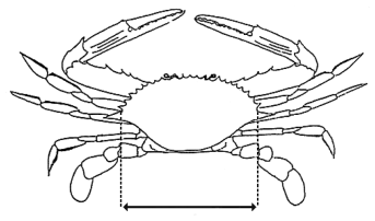
(1)The size of a blue swimmer crab must be decided by measuring the distance between—(a)the notch at the base of the large lateral spine of the crab on one side of the crab; and(b)the notch at the base of the large lateral spine of the crab on the other side of the crab.(2)The following figure is an example of the operation of subsection (1) in diagrammatic form—
The distance between the 2 vertical dotted lines is the distance to be measured to decide the size of a blue swimmer crab.
125Fin fish—general provisions
(1)The size of a fin fish is decided by measuring, with the fish in the required position—(a)for a flathead, shark or ray—the distance along a straight horizontal line along the centre of the fish’s underside from the foremost point of the fish to the end of its tail; or(b)for a fin fish, other than a fish mentioned in paragraph (a)—the distance along a straight horizontal line (the measurement line) along the fish’s side from its mouth to—(i)the point on the measurement line where the fish’s tail ends; or(ii)if part of the tail extends further than the point on the measurement line where the fish’s tail ends—the point on the measurement line corresponding in length with the end of the longest part of the fish’s tail.(2)For subsection (1), the size of the fin fish must be measured without manipulating the fish, other than to the extent reasonably necessary to allow the fish to be measured as required under the subsection.(3)In this section—required position means—(a)for a fish mentioned in subsection (1)(a)—lying on its underside; or(b)for a fish mentioned in subsection (1)(b)—lying on its side with the dorsal fin facing outward and its mouth closed.(4)The following figure is an example of the operation of subsections (1)(b) and (3), definition required position, in diagrammatic form—
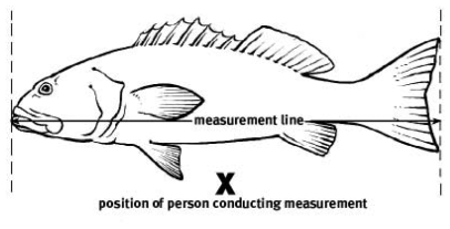
126Fin fish—interdorsal length for guitarfish, shark or shovelnose ray
(1)The interdorsal length for a guitarfish, shark or shovelnose ray must be decided by measuring the distance along a straight line between—(a)the point where the posterior edge of the first dorsal fin is, or was, attached to the body; and(b)the point where the posterior edge of the second dorsal fin is, or was, attached to the body.(2)The following figure is an example of the operation of subsection (1) in diagrammatic form—
The distance between the 2 vertical lines is the distance to be measured to decide the interdorsal length for a guitarfish, shark or shovelnose ray.
s 126 amd 2020 SL No. 236 s 57
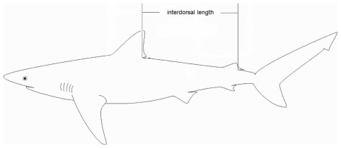
The size of a painted crayfish must be decided by measuring, in a straight line—(a)if its carapace is not damaged or separated from its body—from the anterior mid-dorsal margin to the posterior mid-dorsal margin of the cephalothorax; or(b)if its carapace is damaged or separated from its body—along the dorsal surface from the anterior margin of the first abdominal somite to the posterior margin of the sixth abdominal somite, when the tail is laid flat on a horizontal surface.
The size of a pearl oyster must be decided by measuring from the edge of its butt or hinge to the opposite edge of its shell, whether or not the shell is broken or chipped.
The size of a red champagne lobster must be decided by measuring, in a straight line, from the anterior mid-dorsal margin to the posterior mid-dorsal margin of the cephalothorax.
The size of a saucer scallop must be decided by measuring the widest part of its shell, whether or not the shell is broken or chipped.
(1)The size of a spanner crab must be decided by measuring the shortest distance between—(a)the tip of the spike at the middle of the front edge of its carapace; and(b)the midpoint of the rear edge of its carapace.(2)If the carapace is damaged or separated from the spanner crab’s body, the size of the crab must be decided by measuring its sternite at the widest part of the front of its breastplate, located directly in front of the bases of the main claws.
The size of a trochus must be decided by measuring the widest part of the base of its shell.
133How total volume must be measured
(1)This section provides for how a total volume of fish must be measured.(2)The volume of fish that are in a container (contained fish) must be measured by reference to the volume of the container when it is empty.1An empty container with internal dimensions of 571mm x 381mm x 305mm, commonly called a ‘lug basket’, has a volume of approximately 66L.2An empty container with internal dimensions of 605mm x 280mm x 90mm, commonly called a ‘prawn carton’, has a volume of approximately 15L.(3)For subsection (2), a fish is not a contained fish if any part of it protrudes above the top of the container.(4)The volume of any of the fish that are not contained fish (uncontained fish) must be measured by—(a)placing them in a container or containers so that no part of any of the fish protrudes above the top of the container or containers; and(b)measuring the volume of each container when it is empty; and(c)referring to the volume of the container or containers.(5)The total volume of fish is worked out by adding together the volume of all of the contained and uncontained fish.
(1)This section provides for how the weight of a green snail must be decided.(2)The weight of a green snail is its empty shell weight.
135Threshold percentage of saucer scallops
(1)This section provides for working out the threshold percentage of undersized scallops that are included in a quantity of saucer scallops that have been taken or possessed by a person.(2)The threshold percentage must be worked out by—(a)counting all of the undersized scallops and expressing the number of undersized scallops as a percentage of the total number of saucer scallops taken or possessed; or(b)statistical sampling and testing as follows—(i)collecting information (the sample data) about the total number of saucer scallops taken or possessed by taking a random sample of the scallops and counting the number of undersized scallops;(ii)using the sample data and a statistical method to estimate, based on a probability of 95%, the percentage of the total number of undersized scallops taken or possessed.(3)For subsection (2)(b), a saucer scallop that is not whole, including, for example, a saucer scallop that is cut, dismembered, shelled or shucked, must not be counted or included in a sample.(4)In this section—undersized scallops means saucer scallops that are less than the regulated minimum size provided for saucer scallops under a regulated fish declaration.
(1)This chapter provides for regulated fishing apparatus declarations under sections 33 and 36(1) of the Act.(2)Parts 2 to 5 regulate the carrying out of particular activities in relation to particular fishing apparatus.
137Regulation of commercial fishing apparatus
(1)A person must not buy, sell, possess or use commercial fishing apparatus unless—(a)the person holds, or is acting under, an authority that authorises the purchase, sale, possession or use of the apparatus; or(b)the person is authorised to buy, sell, possess or use the apparatus under a provision of the Fisheries (General) Regulation 2019 or the Fisheries (Commercial Fisheries) Regulation 2019.(2)Despite subsection (1), an Aboriginal person or Torres Strait Islander may possess, but not use, a commercial fishing net without an authority if the net—(a)has a mesh size of at least 50mm but no more than 215mm; and(b)is no longer than 80m.(3)A person must not sell commercial fishing apparatus to a person who is not authorised to buy the apparatus under an authority or a provision of the Fisheries (General) Regulation 2019 or the Fisheries (Commercial Fisheries) Regulation 2019.s 137 amd 2019 SL No. 181 s 27 sch 1
138General restrictions on using nets
A person must not do any of the following things—(a)join 2 or more nets;(b)allow nets to overlap;(c)set nets less than 1m apart;(d)place a thing or do something else between 2 nets to stop fish escaping.
139Possessing or using purse seine nets
A person must not do the following in Queensland waters—(a)possess a purse seine net;(b)use a purse seine net to take fish.
140Using nets in commercial fisheries
(1)A person using a net in a fishery area of a commercial fishery must not, without a reasonable excuse, do anything that effectively reduces the mesh size of the net below the minimum size stated for the net in an authority or a fishery provision about the fishery.Examples of doing something that effectively reduces a net’s mesh size—
covering a net or overlapping nets(2)However, subsection (1) does not apply to doing something that effectively reduces a net’s mesh size if doing the thing is authorised under an authority or a fishery provision about the commercial fishery.s 140 amd 2019 SL No. 181 s 27 sch 1
140AA Possessing or using trawl nets in particular waters in particular period
(1)A person must not possess or use a trawl net in the central trawl region or northern trawl region in the period from midday on 15 December to midday on 1 March.(2)Subsection (1) does not apply to a person who possesses or uses a trawl net on a boat if—(a)the possession or use is only for testing the net or other fishing apparatus normally used with the net; and(b)the person in control of the boat has given the nearest Queensland Boating and Fisheries Patrol oral or written notice of the testing; and(c)the net’s cod ends are open; and(d)no fish are taken during the test.(3)A notice under subsection (2)(b) must—(a)be given at least 24 hours before the testing starts; and(b)state—(i)a square area, with boundaries no longer than 1n mile each side, where the testing is to happen; and(ii)when the testing is to start and end.(4)Also, a person may possess a trawl net in the waters in the period mentioned in subsection (1) if the net is stowed and secured on a boat.(5)For subsection (4), an otter trawl net is stowed and secured on a boat only if—(a)during the daytime—(i)the net and any other fishing apparatus normally used with the net are drawn up to the boat and are visible from an aircraft or another boat; and(ii)the net’s cod ends are open; and(iii)the net’s lazy lines are on the blocks; and(b)at night—(i)the boat is at anchor in an area marked as an anchorage or boat harbour on a navigational chart; or(ii)the net and other fishing apparatus are inboard the boat and are stored or suspended from a mast or boom.Examples of other fishing apparatus—
otter boards, ground chains or ropes for an otter trawl nets 140AA ins 2020 SL No. 236 s 58
ch 4 pt 3A hdg ins 2019 SL No. 181 s 21
140A Possessing or using crab apparatus
(1)This section applies if—(a)there is more than 1 person on a boat; and(b)the boat is taking part in a licensed charter fishing trip; and(c)the persons on the boat are possessing or using crab apparatus to take spanner crabs.(2)The person conducting the licensed charter fishing trip must ensure—(a)the persons on the boat do not—(i)possess or use more than a total of 20 items of crab apparatus; or(ii)fix more than a total of 10 items of crab apparatus to a line; and(b)for an item of crab apparatus that is a dilly—the crab apparatus is marked in a way that complies with the Fisheries (Commercial Fisheries) Regulation 2019, schedule 7, section 25.s 140A ins 2019 SL No. 181 s 21
This division applies to a recreational fisher for taking fish in non-tidal waters.
142Particular fishing apparatus
A recreational fisher must not use any of the following fishing apparatus—(a)a cast net;(b)a crab pot;(c)a fork;(d)a hand pump;(e)a seine net;(f)a spear;(g)a spear gun.
A recreational fisher may use a scoop net only if the net—(a)is no more than 1m in any dimension; and(b)has a mesh size of no more than 25mm and a handle or shaft no longer than 2.5m.
A recreational fisher may use a canister trap only if—(a)the trap—(i)is open at 1 end; and(ii)has a diameter at its open end of no more than 50cm; and(iii)is no longer than 60cm; and(b)the trap’s diameter, width or height, measured anywhere along its length, is no more than the diameter, width or height of its open end; and(c)for a canister trap that does not have a mesh made of rigid material—the size of its mesh is no more than 25mm; and(d)the trap is used in compliance with section 150.
A recreational fisher may use a collapsible trap only if it is used in compliance with section 150.
A recreational fisher may use a dilly only if—(a)the dilly has—(i)a diameter of no more than 125cm; and(ii)a mesh size of no more than 25mm; and(b)the dilly is used in compliance with section 150.
A recreational fisher may use a funnel trap only if—(a)the trap—(i)has no more than 4 entrances; and(ii)is no longer than 70cm, no wider than 50cm and no higher than 50cm; and(b)for a funnel trap that does not have a mesh made of rigid material—the size of the mesh is no more than 25mm; and(c)the trap has an entrance made of rigid material; and(d)for a funnel trap used in eastern non-tidal waters—the trap’s entrance is no more than 5cm in any dimension; and(e)for a funnel trap used in non-tidal waters other than eastern non-tidal waters—the trap’s entrance is no more than 10cm in any dimension; and(f)the trap is used in compliance with section 150.
A recreational fisher may use a pyramid trap only if—(a)the trap—(i)is a pyramid shape; and(ii)has no more than 1 entrance; and(iii)has a base of no more than 60cm in length and width; and(iv)is no less than 15cm in height; and(v)has a mesh size of no more than 25mm; and(b)the trap’s entrance—(i)is no less than 15cm in any dimension; and(ii)is made of rigid material; and(iii)is at the narrow end of the trap; and(iv)is parallel to the base of the trap; and(c)the trap is used in compliance with section 150.
A recreational fisher may use a round trap only if—(a)the trap—(i)has no more than 4 entrances; and(ii)has a diameter of no more than 70cm; and(iii)is no higher than 50cm; and(b)for a round trap that does not have a mesh made of rigid material—the size of the mesh is no more than 25mm; and(c)the trap has an entrance made of rigid material; and(d)for a round trap used in eastern non-tidal waters—the trap’s entrance is no more than 5cm in any dimension; and(e)for a round trap used in non-tidal waters other than eastern non-tidal waters—the trap’s entrance is no more than 10cm in any dimension; and(f)the trap is used in compliance with section 150.
150Way freshwater traps may be used to take fish
(1)This section states the way a recreational fisher may use a canister trap, collapsible trap, dilly, funnel trap, pyramid trap or round trap (each of which is a freshwater trap) to take fish.(2)The recreational fisher must not use more than a total of 4 freshwater traps, including a combination of freshwater traps.(3)Also, the recreational fisher must ensure—(a)a tag, on which is written, legibly, visibly and in English, the recreational fisher’s surname and address, is attached to the freshwater trap; and(b)while the freshwater trap is being used, it is attached to—(i)something that is stationary above the surface of the water; or(ii)a float that complies with subsection (4).(4)The float must—(a)be solid, light-coloured and clearly visible on the surface of the water; and(b)be no less than 15cm in any dimension; and(c)have written on it, legibly, visibly and in English, the recreational fisher’s surname.s 150 amd 2019 SL No. 181 s 22; 2020 SL No. 236 s 82 sch 1
(1)This section does not apply to the use of a fishing line or set line in waters on privately owned land that are not waters of a waterway.Example of waters to which the section does not apply—
a pond or dam on private land that is not part of a waterway(2)A recreational fisher must not—(a)at any one time, use more than 6 fishing lines; or(b)use a set line; or(c)set a fishing line as a cross-line; or(d)attach more than 1 hook or lure to a fishing line the fisher is using; or(e)be more than 50 metres from any fishing line the fisher is using.
This division applies to a recreational fisher for taking fish in tidal waters or on tidal land.
153Canister, funnel, pyramid or round traps
A recreational fisher must not use a canister trap, funnel trap, pyramid trap or round trap.
A recreational fisher may possess or use a cast net only if the net—(a)is no longer than 3.7m; and(b)has a mesh size of no more than 28mm.
A recreational fisher may use a scoop net only if the net—(a)is no more than 2m in any dimension; and(b)has a mesh size of at least 25mm and a handle or shaft no longer than 2.5m.
A recreational fisher may possess or use a seine net only if—(a)the net—(i)is no longer than 16m; and(ii)has a mesh size of no more than 28mm; and(iii)does not contain a pocket; and(iv)is not fixed; and(b)the net’s drop is no more than 3m.
(1)A recreational fisher—(a)must not possess or use more than a total of 4 items of crab apparatus in any waters; and(b)may use crab apparatus only in compliance with subsections (2) and (3).(2)The recreational fisher must ensure that—(a)a tag, on which is written, legibly, visibly and in English, the recreational fisher’s surname and address, is attached to the crab apparatus; and(b)the crab apparatus is attached by a rope to either—(i)a float complying with subsection (3); or(ii)a fixed object above the high water mark, including, for example, a jetty or tree; and(c)if the crab apparatus is attached to a fixed object under paragraph (b)(ii)—a tag, on which is written, legibly, visibly and in English, the recreational fisher’s surname, is attached to the part of the rope above the high water mark.(3)For subsection (2)(b)(i), the float must—(a)be solid, light-coloured and clearly visible on the surface of the water; and(b)be no less than 15cm in any dimension; and(c)have written on it, legibly, visibly and in English, the recreational fisher’s surname.s 157 amd 2019 SL No. 181 s 23; 2020 SL No. 236 s 59
(1)A recreational fisher must not use more than 3 fishing lines at a time.(2)Also, the recreational fisher must not attach more than a total of 6 hooks or lures to the fishing lines the fisher is using.A recreational fisher might use—(a)1 fishing line with 6 hooks attached; or(b)2 fishing lines each with 1 lure attached and another fishing line with 4 hooks attached.(3)A recreational fisher must not use a set line.
A recreational fisher may use a handheld fork only to take worms.
A recreational fisher may use a hand pump only to take yabbies.
161Person may carry out activity under permit
A person may carry out an activity in relation to fishing apparatus that is otherwise prohibited under a provision of part 2, 3 or 4 if the person carries out the activity under a permit.
(1)This chapter provides for regulated fishing method declarations under sections 33 and 36(2) of the Act.(2)Parts 2 to 4 regulate how particular fish may be taken.
163Taking fish using fishing apparatus
(1)This section applies to a person who takes fish using fishing apparatus in a way that may involve taking fish the person does not intend to keep, including, for example, taking fish unintentionally.(2)The person may take fish using the fishing apparatus in the way only if—(a)the person is taking fish the person intends to keep; and(b)the person immediately releases fish the person does not intend to keep into water deep enough to allow the fish to escape; and(c)the person does not allow a part of the apparatus containing fish the person does not intend to keep to be out of the water other than to immediately remove the fish from the apparatus and release the fish under paragraph (b).(3)Subsection (2)(b) and (c) do not apply if the person has a reasonable excuse.
164Particular fishing methods prohibited
(1)A person must not take fish in any of the following ways—(a)by jagging or foul-hooking;(b)using underwater breathing apparatus, other than a snorkel;(c)using a crab hook;(d)using fishing apparatus across a waterway or navigation channel in a way that makes more than half of its width impassable to a boat or fish.(2)In this section—crab hook means a hook, other than a baited hook, used for impaling or extracting crabs.jagging or foul-hooking means using a device consisting of a hook or a collection of hooks that is used, other than with a lure or bait, to take fish.
165Taking fish using particular bait
A recreational fisher may take fish from non-tidal waters using bait taken from tidal waters only if the bait has been cooked, frozen or preserved.Examples of ways in which bait may be preserved—
dried, freeze-dried, pickled, preserved in alcohol, salted
166Person may carry out activity under permit
A person may carry out an activity in relation to taking fish that is otherwise prohibited under a provision of part 2 or 3 if the person carries out the activity under a permit.
ch 6 hdg sub 2019 SL No. 181 s 24
ch 6 pt 1 hdg ins 2019 SL No. 181 s 24
167Prescribed commercial catch for black jewfish for 2019
(1)For 2019, the prescribed commercial catch for black jewfish is the total weight of fish of the species taken by all commercial fishers that is—(a)calculated periodically by the chief executive from 13 May 2019 to the day the calculation is made; andUnder the expired Fisheries Regulation 2008, section 765, the chief executive started to calculate the prescribed commercial catch for black jewfish for 2019 on 13 May 2019.(b)published by the chief executive in a form that is likely to be accessible for commercial fishers.Examples of a form of publication for paragraph (b)—
a recorded message on the AIVR system or a notice published on the department’s website(2)Subsection (1) applies despite schedule 5, definition prescribed commercial catch, paragraph (b).s 167 amd 2019 SL No. 181 s 27 sch 1
Part 2 Transitional provision for Fisheries Amendment Declaration 2019
ch 6 pt 2 hdg ins 2019 SL No. 181 s 25
168Start of regulated periods for particular declarations for 2019
For 2019, the regulated periods for each of the following provisions start on 1 September 2019—•section 33(2);•section 39A(3);•section 86(3)(a).s 168 ins 2019 SL No. 181 s 25
1 | 2 | 3 |
Name of regulated waters | Description of regulated waters | Provisions regulating activities in regulated waters |
coral reef fin fish waters | tidal waters within the following boundary— • from the northern tip of Cape York along latitude 10º41' south • to longitude 145º east • to latitude 13º south, longitude 145º east • to latitude 15º south, longitude 146º east • to latitude 17º30' south, longitude 147º east • to latitude 21º south, longitude 152º55' east • to latitude 24º30' south, longitude 154º east • to latitude 24º50' south, longitude 154º east • along latitude 24º50' south to the mainland shore • along the shore to the northern tip of Cape York at latitude 10º41' south | |
northern rocklobster waters | the following waters— • tidal waters north of latitude 14º south and east of longitude 142º31'49'' east • tidal waters west of longitude 142º31'49'' east | |
sea cucumber waters | the following waters— • tidal waters south of latitude 20º south (near Bowen) • tidal waters west of longitude 142º31'49'' east | |
spanish mackerel waters | waters east of longitude 142º09' east | |
spanner crab waters | the following waters— • tidal waters south of latitude 23º south and east of longitude 151º45' east • tidal waters north of the waters mentioned in the first dot point and east of longitude 142º31'49" east • tidal waters north of latitude 10º48' south and between longitude 141º20' east and longitude 142º31'49" east • tidal waters in the Gulf of Carpentaria between the 25n mile line and the shore of the mainland at high water mark, south of latitude 10º48' south |
1 | 2 | 3 |
Name of regulated waters | Description of regulated waters | Provisions regulating activities in regulated waters |
regulated tidal waters | tidal waters in Queensland waters | sections 28 and 35 |
waterways, lakes and lagoons within the limits of the State | waterways, lakes and lagoons within the limits of the State | |
lakes and lagoons south of the northern bank of the Endeavour River and east of longitude 142º31'49" east | waters shown as regulated waters on FRW-014 | |
southern regional waters | waters within the following boundary, other than waters of Moreton Bay (trawling)— • from the intersection of latitude 28º09.88' south with the mainland shore at high water mark (at the State’s border with New South Wales, approximately latitude 28º09.88' south, longitude 153º33.10' east) along the shore to latitude 22º00.00' south (approximately at latitude 22º00.00' south, longitude 149º29.68' east) • to latitude 22º00.00' south, longitude 152º56.58' east • to latitude 22º19.18' south, longitude 153º00.32' east • to latitude 22º38.63' south, longitude 152º43.43' east • to latitude 22º44.90' south, longitude 152º10.56' east • to latitude 22º34.40' south, longitude 151º56.06' east • to latitude 23º11.13' south, longitude 151º54.16' east (the light on north reef) • to latitude 23º54.49' south, longitude 152º23.38' east (the light on Lady Musgrave Island) • to latitude 24º06.88' south, longitude 152º42.68' east (the light on Lady Elliot Island) • to latitude 24º21.05' south, longitude 153º08.83' east (the Breaksea spit light off the northern tip of Fraser Island) • to latitude 24º29.90' south, longitude 153º20.06' east • to latitude 24º59.90' south, longitude 153º35.06' east | |
• to latitude 26º09.90' south, longitude 153º50.06' east • to latitude 26º19.90' south, longitude 153º40.76' east • to latitude 26º29.90' south, longitude 153º34.06' east • to latitude 26º40.90' south, longitude 153º31.06' east • to latitude 27º01.90' south, longitude 153º31.26' east • to latitude 27º25.90' south, longitude 153º39.06' east • to latitude 28º03.48' south, longitude 153º47.06' east • to the intersection of latitude 28º09.88' south with the mainland shore at high water mark | ||
southern offshore trawl region | waters within the following boundary— • from latitude 28º09.88' south, longitude 153º33.10' east (point on the shore at the State’s border with New South Wales at high water mark) along the shore and breakwall to latitude 27º56.12' south, longitude 153º25.99' east (seaward end of the southern Gold Coast Seaway breakwall) • to the northern tip of Gold Coast Seaway breakwall latitude 27º56.06' south, longitude 153º25.83' east • along the eastern shore of South Stradbroke Island to latitude 27º44.83' south, longitude 153º26.90' east • to latitude 27º43.43' south, longitude 153º27.26' east • along the eastern shore of North Stradbroke Island to latitude 27º23.64' south, longitude 153º26.40' east (Amity Point) • to latitude 27º21.82' south, longitude 153º25.68' east (Reeders Point) • along the eastern shore of Moreton Island to latitude 27º03.68' south, longitude 153º21.71' east (Comboyuro Point) • to the southern tip of the sand spit between Kings Beach and Bulcock Beach, Caloundra • along the shore to latitude 25º48.68' south, longitude 153º03.89' east (F↑B sign at Inskip Point) • to latitude 25º47.52' south, longitude 153º04.62' east (F↑B sign at Hook Point) • along the eastern shore of Fraser Island to latitude 24º41.81' south, longitude 153º15.95' east • to latitude 24º17.69' south, longitude 153º02.83' east • to latitude 24º15.16' south, longitude 152º58.10' east | sections 86 and 86AA |
• to latitude 24º13.68' south, longitude 152º45.45' east • to latitude 23º12.76' south, longitude 151º50.85' east • to latitude 22º32.00' south, longitude 152º17.11' east • to latitude 22º26.57' south, longitude 152º53.90' east • to latitude 22º00.00' south, longitude 152º46.87' east • to latitude 21º08.04' south, longitude 152º33.12' east • to latitude 21º08.97' south, longitude 152º48.00' east • to latitude 21º09.05' south, longitude 154º00.87' east • to latitude 22º14.89' south, longitude 154º40.08' east • to latitude 27º47.32' south, longitude 154º40.08' east • to latitude 27º47.89' south, longitude 154º22.08' east • to latitude 27º57.91' south, longitude 154º00.06' east • to latitude 28º09.88' south, longitude 153º33.10' east (point on the shore at the State’s border with New South Wales at high water mark) | ||
near the New South Wales border to Point Lookout on North Stradbroke Island | waters within the following boundary— • from latitude 28º09.90' south on the territorial sea baseline (approximately latitude 28º09.90' south, longitude 153º33.09' east) along the territorial sea baseline to latitude 27º26.06' south (Point Lookout, North Stradbroke Island, approximately latitude 27º26.06' south, longitude 153º32.78' east) | |
• to latitude 27º26.10' south, longitude 153º34.66' east • to latitude 27º29.90' south, longitude 153º32.66' east • to latitude 27º33.70' south, longitude 153º31.26' east • to latitude 27º36.30' south, longitude 153º30.47' east • to latitude 27º43.50' south, longitude 153º29.27' east • to latitude 27º48.10' south, longitude 153º28.26' east • to latitude 27º52.90' south, longitude 153º27.66' east • to latitude 27º55.10' south, longitude 153º27.47' east • to latitude 27º56.30' south, longitude 153º27.86' east • to latitude 27º59.90' south, longitude 153º27.86' east • to latitude 28º04.30' south, longitude 153º29.06' east • to latitude 28º05.90' south, longitude 153º30.06' east • to latitude 28º06.50' south, longitude 153º30.47' east • to latitude 28º06.70' south, longitude 153º30.86' east • to latitude 28º08.10' south, longitude 153º31.86' east • to latitude 28º08.10' south, longitude 153º33.47' east | ||
• to latitude 28º08.50' south, longitude 153º34.07' east • to latitude 28º09.10' south, longitude 153º34.86' east • to latitude 28º09.90' south on the territorial sea baseline | ||
southern trawl fishery area waters | waters within the following boundary— • from latitude 27º57.91' south, longitude 154º00.06' east to latitude 28º09.88' south, longitude 153º33.10' east (point on the shore at the State’s border with New South Wales at high water mark) • along the shore and breakwall to latitude 27º56.12' south, longitude 153º25.99' east (seaward end of the southern Gold Coast Seaway breakwall) • to the northern tip of Gold Coast Seaway breakwall latitude 27º56.06' south, longitude 153º25.83' east | |
• along the eastern shore of South Stradbroke Island to latitude 27º44.83' south, longitude 153º26.90' east • to latitude 27º43.43' south, longitude 153º27.26' east • along the eastern shore of North Stradbroke Island to latitude 27º23.64' south, longitude 153º26.40' east (Amity Point) • to latitude 27º21.82' south, longitude 153º25.68' east (Reeders Point) • along the eastern shore of Moreton Island to latitude 27º03.68' south, longitude 153º21.71' east (Comboyuro Point) • to latitude 27º05.08' south, longitude 153º12.43' east (Skirmish Point) • along the eastern shore of Bribie Island to latitude 26º50.05' south, longitude 153º07.78' east • to latitude 26º48.38' south, longitude 153º08.36' east (southern end of Kings Beach) • along the shore and breakwall to latitude 26º40.74' south, longitude 153º07.95' east (southern breakwall of Mooloolaba Harbour) • to latitude 26º40.80' south, longitude 153º07.93' east (northern broadway of Mooloolaba Harbour) • along the shore to latitude 25º48.68' south, longitude 153º03.62' east (the F↑B sign at Inskip Point) • along the eastern shore of Fraser Island to latitude 24º41.83' south, longitude 153º16.00' east (Sandy Cape) • to latitude 24º06.88' south, longitude 152º42.68' east (the light on Lady Elliot Island) | ||
• to latitude 23º54.49' south, longitude 152º23.38' east (the light on Lady Musgrave Island) • to latitude 23º11.13' south, longitude 151º54.16' east (the light on North Reef) • to latitude 22º34.40' south, longitude 151º56.06' east • to latitude 22º44.90' south, longitude 152º10.56' east • to latitude 22º38.63' south, longitude 152º43.43' east • to latitude 22º19.18' south, longitude 153º00.32' east • to latitude 22º00.00' south, longitude 152º56.58' east • to latitude 22º00.00' south, longitude 154º31.25' east • to latitude 22º14.90' south, longitude 154º40.08' east • to latitude 27º47.32' south, longitude 154º40.08' east • to latitude 27º47.90' south, longitude 154º22.08' east • to latitude 27º57.91' south, longitude 154º00.06' east | ||
waters other than the Gulf of Carpentaria waters | Queensland waters other than the Gulf of Carpentaria waters | sections 20 and 22 |
waterways south of Double Island Point | waterways south of Double Island Point and adjoining waterways | |
jetties in, or south of, Noosa River | waters under, or within 100m of, any public jetty in, or south of, Noosa River | |
particular waters of the Murray–Darling drainage division | waters of the Murray–Darling drainage division, other than the following dams— • Beardmore Dam • Beehive Dam • Connolly Dam • Cooby Dam • Coolmunda Dam • Glenlyon Dam • Leslie Dam • Storm King Dam | |
Dumaresq River at Bonshaw Weir | Dumaresq River from Bonshaw Weir to 100m downstream of Bonshaw Weir | |
Pike Creek at Glenlyon Dam | Pike Creek from 100m upstream to 200m downstream of the Glenlyon Dam wall | |
Barwon River at Mungindi Weir | Barwon River from Mungindi Weir to 100m downstream of Mungindi Weir | |
Severn River at Queen Mine Waterhole | the part of the Severn River commonly known as Queen Mine Waterhole, about 6km west of Ballandean | |
Quart Pot Creek at Storm King Dam | Quart Pot Creek from 100m upstream to 200m downstream of the Storm King Dam wall | |
Balonne River at Beardmore Dam and Jack Taylor Weir | the following waters of Balonne River— • from 100m upstream to 200m downstream of the Beardmore Dam wall • from 100m upstream to 200m downstream of Jack Taylor Weir | |
The Broadwater (southern part) and Nerang River | the following waters— • Nerang River and adjoining waterways • the part of The Broadwater upstream of a line between a point on the shore of The Broadwater in line with the northern edge of Stevens Street, Southport and the F↑B sign on the shore of The Spit near the floating helipad near Seaworld | |
Gold Coast Seaway | the Gold Coast Seaway within the following boundary— • from the F↑B sign west of the Seaway Tower on the northern shore of The Spit to the F↑B sign on South Stradbroke Island west of the island’s southern tip • along the island’s southern shore to the seaward end of the Seaway’s northern breakwater wall • to the seaward end of the Seaway’s southern breakwater wall at Nerang Head on The Spit • along The Spit’s northern shore to the F↑B sign west of the Seaway Tower on The Spit’s northern shore | |
The Broadwater (central part) | The Broadwater within the following boundary— • from the F↑B sign on the opposite side of The Broadwater’s western navigation channel from a point on the shore in line with the northern edge of Stevens Street, Southport, along the eastern edge of the channel to the flashing green beacon nearest to the northern tip of Carters Bank • to the southern tip of Crab Island • to the F↑B sign on South Stradbroke Island westerly of the island’s southern tip • to the F↑B sign westerly of the Seaway Tower on The Spit’s northern shore • along The Spit’s shore by the shortest route to the F↑B sign near the floating helipad near Seaworld • to the F↑B sign on the opposite side of The Broadwater’s western navigation channel from a point on the shore in line with the northern edge of Stevens Street, Southport | |
The Broadwater (western part) | The Broadwater within the following boundary— • from a point on the shore in line with the northern edge of Stevens Street, Southport, along the shore to the F↑B sign near the southern bank of the southern branch of the Coomera River • towards the north-western tip of the northernmost island of the Sovereign Islands for 140m • along a line parallel to, and 140m from, Sovereign Island’s western shore, to a line from the F↑B sign at the corner of the Esplanade and Nankeen Avenue, Paradise Point to the northern tip of Ephraim Island • to the southern tip of Ephraim Island • to the northern tip of Crab Island • to the southern tip of Crab Island • to the flashing green beacon marking the eastern edge of the western navigation channel, nearest to Carters Bank • along the channel’s eastern edge to the F↑B sign in line with the northern edge of Stevens Street, Southport • to the point on the shore in line with the northern edge of Stevens Street, Southport | |
Macintyre River at Goondiwindi Weir | Macintyre River from 150m upstream to 150m downstream of Goondiwindi Weir | |
Macintyre Brook at Coolmunda Dam, Whetstone and Bendor weirs | the following waters of Macintyre Brook— • from 100m upstream to 200m downstream of the Coolmunda Dam spillway wall • from 100m upstream to 200m downstream of Whetstone Weir • from 100m upstream to 200m downstream of Bendor Weir | |
Sandy Creek at Leslie Dam | Sandy Creek from 100m upstream to 200m downstream of the Leslie Dam wall | |
Burnett Creek at Maroon Dam | Burnett Creek from 100m upstream to 200m downstream of the Maroon Dam wall | |
Currumbin Creek | waters shown as regulated waters on FRW-017 | |
Currumbin Beach | waters shown as regulated waters on FRW-016 | |
Tallebudgera Creek (netting) | waters shown as regulated waters on FRW-018 | |
Tallebudgera Creek to Burleigh (netting) | foreshore waters and waters within 400m out to sea from the shore at low water, between the southern bank of Tallebudgera Creek and a point on the shore in line with the northern edge of First Avenue, Burleigh Heads | |
Tallebudgera Creek (spearing) | Tallebudgera Creek upstream of a line between the SF↑B signs at the eastern tip of Burleigh Head and the seaward end of the rock groyne near its southern bank | |
Reynolds Creek at Moogerah Dam | Reynolds Creek from 100m upstream to 200m downstream of the Moogerah Dam wall | |
Nerang River at Hinze Dam | Nerang River from 100m upstream to 600m downstream of the Hinze Dam wall | |
Teviot Brook at Wyaralong Dam | Teviot Brook from 100m upstream to 200m downstream of the Wyaralong Dam wall | |
Coombabah Creek, Oyster Lake and Saltwater Creek | Saltwater Creek and Coombabah Creek (including Oyster Lake), downstream from Coombabah Lake | |
Coombabah Lake and Coombabah Creek | waters shown as regulated waters on FRW-024 | |
Coomera River (upstream) | Coomera River and adjoining waterways, upstream of its junction with Guanaba Creek at the creek’s southern bank | |
Coomera River | the southern branch of the Coomera River downstream of the F↑B signs on opposite sides of the southern branch at its junction with the river’s northern branch | |
Moreton Bay (whole) | waters within the following boundary— • from the F↑B sign at the south-eastern tip of Toorbul Point to the F↑B sign at the southern end of South Esplanade, Bongaree, Bribie Island • along Bribie Island’s western and southern shores to Skirmish Point • to Comboyuro Point, Moreton Island • along Moreton Island’s western shore to Reeders Point • to Amity Point, North Stradbroke Island • along North Stradbroke Island’s western and southern shores to its south-eastern tip • to the north-eastern tip of South Stradbroke Island • along South Stradbroke Island’s northern, western and southern shores to the seaward tip of the northern breakwater wall of the Gold Coast Seaway • to the seaward tip of the southern breakwater wall of the Gold Coast Seaway at Nerang Head on The Spit • along the shore of The Spit to the Gold Coast Highway bridge over the Nerang River near Waterways Drive, Main Beach • along the eastern side of the Gold Coast Highway bridge to the mainland shore • along the shore to the F↑B sign at the south-eastern tip of Toorbul Point | |
Southern Moreton Bay (including The Broadwater) | Moreton Bay south of latitude 27º42' south, other than waters between the following lines— • a line from the SF↑B sign at The Bedroom, South Stradbroke Island, to the SF↑B sign on the north-eastern shore of Woogoompah Island • a line from the SF↑B sign at Currigee, South Stradbroke Island, to the SF↑B sign on the shore at Hollywell | |
Swan Bay | waters shown as regulated waters on FRW-027 | |
Albert River (upstream) | Albert River and adjoining waterways, upstream of its junction with Canungra Creek at the creek’s northern bank | |
Albert River at Luscombe Weir | Albert River from 100m upstream to 200m downstream of Luscombe Weir | |
south of North Stradbroke Island | waters south of the southern tip of North Stradbroke Island | |
Stradbroke Island (trawl nets) | waters within the following boundary— • from latitude 27º50.188' south, longitude 153º28.557' east to latitude 27º50.230' south, longitude 153º29.347' east • to latitude 27º42.645' south, longitude 153º30.683' east • to latitude 27º40.766' south, longitude 153º29.725' east • to latitude 27º43.500' south, longitude 153º29.270' east • to latitude 27º46.531' south, longitude 153º28.604' east • to latitude 27º46.580' south, longitude 153º29.193' east • to latitude 27º50.188' south, longitude 153º28.557' east | |
Moreton Bay (area 1) | Moreton Bay north of the southern tip of North Stradbroke Island and south of a line from Victoria Point to Pott’s Point, Macleay Island to Blakesleys Camp, North Stradbroke Island | |
Running Creek | Running Creek (which flows into Logan River) and adjoining waterways, upstream of the line between its banks | |
Christmas Creek | Christmas Creek (which flows into Logan River) and adjoining waterways, upstream of the line between its banks | |
Logan River at South Maclean and Cedar Grove weirs | the following waters of Logan River— • from 100m upstream to 200m downstream of South Maclean Weir • from 100m upstream to 200m downstream of Cedar Grove Weir | |
Amity Bight and the South Passage | waters within the following boundary— • from latitude 27º26.06' south on North Stradbroke Island’s north-eastern shore (Point Lookout, approximately latitude 27º26.06' south, longitude 153º32.78' east), north and west along the shore of North Stradbroke Island to latitude 27º23.64' south (Amity Point, approximately latitude 27º23.64' south, longitude 153º26.40' east) • to longitude 153º25.68' east on Moreton Island’s southern shore (Reeders Point, approximately latitude 27º21.82' south, longitude 153º25.68' east) • along Moreton Island’s eastern shore to latitude 27º17.40' south (approximately latitude 27º17.40' south, longitude 153º25.27' east) • to latitude 27º17.40' south, longitude 153º28.56' east • to latitude 27º20.40' south, longitude 153º30.06' east • to latitude 27º26.10' south, longitude 153º34.66' east • to latitude 27º26.06' south on North Stradbroke Island’s north-eastern shore | |
North Stradbroke Island (northern beaches) | waters within 200m from the shore at low water between North Gorge (at the southern end of Frenchman’s Beach) and Adder Rock | |
Dunwich | waters shown as regulated waters on FRW-030 | |
Manly Boat Harbour | Manly Boat Harbour and its foreshores, up to a line between the seaward ends of the harbour’s breakwaters | |
Wynnum and Manly | foreshore waters between the northern breakwater of Manly Boat Harbour and the southern bank of Wynnum Creek | |
Wynnum (worm area) | the following foreshore waters of Wynnum— • waters adjacent to the Esplanade between its intersection with the southern side of Cedar Street and its intersection with the northern side of Charlotte Street • waters within 100m of high water mark between the northern bank of Lota Creek and the rock groyne extending seawards near the northern end of Wynnum North Esplanade | |
Southern Moreton Bay area | waters within the following boundary— • from latitude 27º26.93' south, longitude 153º14.70' east (the A S Huybers flashing red light beacon off King Island, near Wellington Point) to latitude 27º30.30' south, longitude 153º19.35' east (the flashing green light beacon off the western tip of Peel Island) • to latitude 27º32.48' south, longitude 153º20.20' east (the west cardinal light beacon off the northern tip of the bank commonly known as Banana Bank) • to latitude 27º35.20' south, longitude 153º22.83' east (the green light beacon on the south-western side of the Pelican Banks) • to latitude 27º35.65' south, longitude 153º24.27' east (the special mark flashing yellow light beacon at the southern tip of the Pelican Banks) • to latitude 27º34.70' south, longitude 153º24.27' east (the flashing red light beacon on the eastern side of the Pelican Banks) • to latitude 27º34.20' south, longitude 153º24.37' east (the flashing green light beacon off the western shore of North Stradbroke Island) • to latitude 27º32.17' south, longitude 153º24.07' east (the flashing green light beacon off Wallen Wallen) | |
• to latitude 27º31.14' south, longitude 153º23.07' east (the special mark flashing yellow light beacon at the southern tip of Goat Island) • to latitude 27º30.20' south, longitude 153º23.99' east (the southern end of Harold Walker Jetty, Dunwich, North Stradbroke Island) • along the southern side of Harold Walker Jetty to latitude 27º30.14' south on North Stradbroke Island’s western shore (approximately latitude 27º30.14' south, longitude 153º24.08' east) • along North Stradbroke Island’s western shore to latitude 27º29.60' south, longitude 153º24.15' east (the jetty at One Mile Anchorage) • along the southern side of the jetty at One Mile Anchorage to latitude 27º29.58' south, longitude 153º24.13' east (the western end of the jetty) • to latitude 27º29.51' south, longitude 153º22.89' east (the south cardinal light beacon known as Douglas Light) • to latitude 27º27.25' south, longitude 153º19.98' east (the green light beacon that flashes every 6 seconds off Maroom Bank) • to latitude 27º25.99' south, longitude 153º17.41' east (the isolated danger beacon on Hope Banks) • to latitude 27º26.93' south, longitude 153º14.70' east | ||
Brisbane River at Old Mt Crosby Weir | Brisbane River from 100m upstream to 200m downstream of Old Mt Crosby Weir | |
Brisbane River at Mt Crosby Weir | Brisbane River from 100m upstream to 200m downstream of Mt Crosby Weir | |
Brisbane River at Wivenhoe Dam | Brisbane River from 100m upstream to 600m downstream of the Wivenhoe Dam wall | |
Brisbane River (netting) | 1 Brisbane River upstream of the following line—• from the northern tip of the northernmost wharf on Fisherman Island• to the starboard beacon at the junction of the Koopa Channel and Brisbane River Channel• to the rear (seaward) lead of the Lytton Rocks Reach about 900m downstream from Luggage Point• to Luggage Point 2 waterways joining the waters described in item 1 (other than the part of the Boat Passage east of the bridge between Whyte Island and Fisherman Island) | |
Brisbane Airport floodway channel to the Pine River | 1 waterways flowing into Moreton Bay between the southern bank of the Brisbane Airport floodway channel and the southern tip of the Houghton Highway 2 waterways joining the waterways described in item 1 3 Moreton Bay foreshore waters between the southern bank of the Brisbane Airport floodway channel and the southern tip of the Houghton Highway 4 Jacksons Creek (which joins the floodway channel near the channel’s banks) | |
Boggy Creek, Pinkenba | Boggy Creek upstream of a line— • from Luggage Point to the oil tanker berth • along the oil pipeline viaduct to the start of the viaduct on Bulwer Island | |
Flat Rock (grey nurse shark protection area) | waters shown as regulated waters on FRW-302 | |
Cherub’s Cave (grey nurse shark protection area) | waters shown as regulated waters on FRW-304 | |
Henderson Rock (grey nurse shark protection area) | waters shown as regulated waters on FRW-303 | |
Brisbane River mouth area | waters within the following boundary— • from latitude 27º19.70' south, longitude 153º08.91' east to latitude 27º18.40' south, longitude 153º08.91' east • to latitude 27º18.40' south, longitude 153º11.16' east • to latitude 27º19.95' south, longitude 153º11.16' east • to latitude 27º19.70' south, longitude 153º08.91' east | |
Sandgate Pier | waters shown as regulated waters on FRW-038 | |
North Pine River at North Pine Dam | North Pine River from 100m upstream to 200m downstream of the North Pine Dam wall | |
Sideling Creek at Kurwongbah Dam | Sideling Creek from 100m upstream to 200m downstream of the Kurwongbah Dam wall | |
South Pine River and North Pine River | the following waters— • South Pine River upstream of the F↑B signs on opposite sides of the river, about 1.5km upstream from its junction with the North Pine River, at a place known as Stones Corner • North Pine River upstream of the F↑B signs on opposite sides of the river about 2.5km upstream from the northbound bridge across the river near the start of the Bruce Highway | |
Moreton Bay outside M1 and M2 area | waters of Moreton Bay (trawling) outside the M1 and M2 area | |
Moreton Bay (including The Broadwater) | waters shown as regulated waters on FRW-029 | |
Balonne River at Surat Weir | Balonne River from 100m upstream to 200m downstream of Surat Weir | |
northern section of Moreton Bay | waters within the following boundary— • from the intersection of latitude 27º04.93' south with Bribie Island’s western shore (approximately latitude 27º04.93' south, longitude 153º09.48' east) • to latitude 27º09.19' south, longitude 153º03.91' east (the special mark yellow flashing light beacon off the Caboolture River) • to latitude 27º10.97' south, longitude 153º06.14' east (the special mark yellow flashing light beacon No. 1 at the entrance of the Scarborough Boat Harbour) • to latitude 27º10.95' south, longitude 153º06.77' east (north of Castlereagh Point) • to latitude 27º09.20' south, longitude 153º06.77' east • to latitude 27º09.20' south, longitude 153º11.46' east • to latitude 27º12.12' south, longitude 153º17.23' east (the flashing red beacon M8 off Four Fathom Bank) • to latitude 27º12.03' south, longitude 153º18.71' east (the flashing red beacon MB2 off Middle Bank) • to latitude 27º08.36' south, longitude 153º20.75' east (the east cardinal beacon M7 west of Cowan Cowan Point on Moreton Island) • to latitude 27º07.35' south, longitude 153º20.47' east (the flashing yellow beacon M5 west of Cowan Cowan township on Moreton Island) | |
• to latitude 27º05.24' south, longitude 153º18.90' east (the flashing red beacon M4 off Yule Bank) • to latitude 27º03.48' south, longitude 153º18.78' east (the flashing red beacon M2 off Salamander Bank) • to latitude 27º02.75' south, longitude 153º16.22' east (the flashing yellow beacon S1 in Spitfire Channel) • to latitude 27º02.27' south, longitude 153º15.45' east (the west cardinal beacon NW12 in Spitfire Channel) • to latitude 27º00.03' south, longitude 153º14.52' east (the southernmost flashing red beacon NW10 in North-West Channel) • to latitude 27º01.80' south on Bribie Island’s eastern shore (approximately latitude 27º01.80' south, longitude 153º10.89' east) • along Bribie Island’s eastern, southern and western shores to latitude 27º04.93' south on Bribie Island’s western shore | ||
Moreton Island (artificial reef area) | waters within the following boundary— • from the SF↑B sign on the western shore of Moreton Island about 200m north of the Bulwer Wrecks to the lit buoy NE1 about 700m off Bulwer • to the NE1 buoy west of Bulwer • to the M7 beacon west of Cowan Cowan point • to the E1 beacon west of Tangalooma Jetty • to the SF↑B sign on the western shore of Moreton Island at Tangalooma Point • along the shore to the SF↑B sign about 200m north of the Bulwer Wrecks | |
Moreton Island to Double Island Point | waters within the following boundary— • from Double Island Point to North Point, Moreton Island • to Skirmish Point, Bribie Island • along the island’s eastern shore to the F↑B sign at its northern tip • to the southern tip of the sand spit between Kings Beach and Bulcock Beach, Caloundra • along the shore to Double Island Point | |
Stanley River | Stanley River and adjoining waterways, upstream of the full supply level of Somerset Dam | |
Pumicestone Strait (spearing)Note— Pumicestone Strait is also known as Pumicestone Passage. | 1 waters between the following lines—• a line from the SF↑B sign at the southern bank of Elimbah Creek to the SF↑B sign at Gallagher Point, Bribie Island• a line from the SF↑B sign at the northern bank of Ningi Creek to the SF↑B sign at the northern bank of Dux Creek, Bribie Island 2 waters north of a line from the SF↑B sign near the southern bank of Bells Creek to the SF↑B sign at the northern tip of the northernmost island of a group of islands in the strait (easterly of Bells Creek), then easterly to the SF↑B sign on Bribie Island’s western shore | |
Pumicestone Strait (commercial fishing)Note— Pumicestone Strait is also known as Pumicestone Passage. | waters between the following lines and adjoining waterways— • a line from the F↑B sign at the southern end of South Esplanade, Bongaree, Bribie Island to the F↑B sign at the south-eastern tip of Toorbul Point • a line from latitude 26º48.38' south, longitude 153º08.36' east (the groyne at the southern end of Kings Beach) to where latitude 26º49.5' south intersects the eastern shore of Bribie Island | |
Condamine River at Chinchilla, Loudon, Lemon Tree, Yarramalong, Cecil Plains and Reilly’s weirs | the following waters of Condamine River— • from 100m upstream to 200m downstream of Chinchilla Weir • from 100m upstream to 200m downstream of Loudon Weir • from 100m upstream to 200m downstream of Lemon Tree Weir • from 100m upstream to 200m downstream of Yarramalong Weir • from 100m upstream to 200m downstream of Cecil Plains Weir • from 27º02.24' south, 149º57.12' east (approximately 14km upstream from the weir) to 200m downstream of Reilly’s Weir | |
Caloundra to Moreton Island (trawl nets) | waters within the following boundary— • from latitude 26º45.832' south, longitude 153º08.183' east to latitude 26º51.214' south, longitude 153º17.472' east • to latitude 26º56.735' south, longitude 153º30.380' east • to latitude 27º10.300' south, longitude 153º29.700' east • to latitude 27º10.300' south, longitude 153º28.470' east • to latitude 27º17.400' south, longitude 153º28.470' east • to latitude 27º20.230' south, longitude 153º34.000' east • to latitude 27º19.671' south, longitude 153º26.371' east • along the eastern shore of Moreton Island to latitude 27º01.675' south, longitude 153º28.077' east • to latitude 26º58.215' south, longitude 153º29.502' east • to latitude 26º56.732' south, longitude 153º26.570' east • to latitude 26º51.438' south, longitude 153º13.099' east • to latitude 26º51.438' south, longitude 153º10.002' east • to latitude 26º48.141' south, longitude 153º09.047' east • along the shore to latitude 26º45.832' south, longitude 153º08.183' east | |
Caloundra Head | waters within the following boundary— • from latitude 26º44.90' south on the mainland shore (north of Caloundra Head at approximately latitude 26º44.90' south, longitude 153º08.17' east) to latitude 26º44.90' south, longitude 153º12.56' east • to latitude 26º51.90' south, longitude 153º12.56' east • to latitude 26º51.90' south on the western shore of Pumicestone Strait (approximately latitude 26º51.90' south, longitude 153º06.75' east) • along the mainland shore to latitude 26º44.90' south | |
Caloundra (Kings Beach to Shelly Beach) | foreshore waters and waters within 400m out to sea from the shore at low water, between the following lines— • a line running from latitude 26º48.38' south, longitude 153º08.36' east (the groyne at the southern end of Kings Beach) towards where latitude 26º49.5' south intersects the eastern shore of Bribie Island • a line running east-north-east out to sea from the F↑B sign at the southern end of Shelly Beach, Caloundra | |
Currimundi Lake and Currimundi Creek near Caloundra | waters shown as regulated waters on FRW-045 | |
Mooloolah River (spearing) | Mooloolah River from a line between the SF↑B signs near its banks, to the bridge joining Nicklin Way and Brisbane Road | |
Warana Beach at Kawana Waters | waters within the following boundary— • from latitude 26º43.80' south, longitude 153º08.10' east to latitude 26º43.81' south, longitude 153º08.73' east • to latitude 26º43.92' south, longitude 153º08.73' east • to latitude 26º43.91' south, longitude 153º08.10' east • to latitude 26º43.80' south, longitude 153º08.10' east | |
Mooloolah River (netting) | waters shown as regulated waters on FRW-047 | |
Dogwood Creek at Gil Weir (formerly Miles Weir) | Dogwood Creek from 100m upstream to 200m downstream of Gil Weir (formerly Miles Weir) | |
Maroochy River and ocean foreshores (netting) | 1 Maroochy River within the following boundary and adjoining waterways—• from the intersection of latitude 26º38.38' south with the mainland shore• to the intersection of latitude 26º38.87' south with the mainland shore upstream to latitude 26º38.53' south (near the ‘cod hole’) 2 waters within the following boundary—• from the intersection of longitude 153º06.23' east with the mainland shore• to latitude 26º38.57' south, longitude 153º06.10' east• to latitude 26º38.57' south, longitude 153º06.34' east• to latitude 26º39.34' south, longitude 153º06.47' east• to the intersection of longitude 153º06.23' east with the mainland shore | |
Maroochy River (spearing) | Maroochy River and adjoining waterways, downstream of a line from the SF↑B sign on the southern side of the river near the ‘cod hole’ to the SF↑B sign on the northern side of the river near the ‘cod hole’ | |
Obi Obi Creek | Obi Obi Creek between the Baroon Pocket Dam wall and the downstream side of Obi Obi Creek crossing 4 (Manuel Hornibrook Bridge) | |
South Maroochy River and the North Maroochy River | waters shown as regulated waters on FRW-048 | |
Yabba Creek at Borumba Dam | Yabba Creek from 100m upstream to 200m downstream of the Borumba Dam wall | |
Weyba Creek | Weyba Creek and adjoining waterways, downstream of Lake Weyba | |
Stuart River at Gordonbrook Dam | Stuart River from 750m upstream to 200m downstream of the Gordonbrook Dam wall | |
Laguna Bay area | waters within the Laguna Bay area | |
Six Mile Creek at Lake MacDonald | Six Mile Creek from 100m upstream to 200m downstream of the Lake MacDonald dam wall | |
Noosa River and Noosa’s main beach | the following waters— • Noosa River downstream of a line between the F↑B sign on the river’s southern side near Thomas Street, Noosaville and the F↑B sign on the opposite side of the river • foreshore waters of Noosa’s main beach between First Point and the southern bank of Noosa River | |
Noosa River (ocean foreshore) | foreshore waters for 400m (measured along the shore) north of the northern bank of Noosa River and waters within 400m out to sea from that part of the shore at low water | |
Lakes Doonella and Weyba | Lake Doonella and Lake Weyba | |
Noosa River (spearing) | Lake Weyba, Noosa River and waterways joining the lake and river, downstream of a line from the SF↑B sign on Parkyn’s Jetty near the entrance to Doonella Lake to the SF↑B sign on the shore at the western tip of Goat Island | |
Noosa River and Lakes Cooroibah and Cootharaba | Noosa River, Lake Cooroibah and Lake Cootharaba | |
Lake Como, Kin Kin Creek, upper Noosa River and Lake Cootharaba | Lake Como, Kin Kin Creek, Noosa River and the part of Lake Cootharaba north of a line joining the following points— • from the F↑B sign on Lake Cootharaba’s north-western shore to the F↑B sign on the southern tip of the peninsula on the eastern side of Shark Bay (which is part of the lake) • to the F↑B sign at the southern tip of Kinaba Island • to the F↑B sign on Lake Cootharaba’s eastern shore | |
Boyne River (Auburn river basin) at Boondooma Dam | Boyne River in the Auburn river basin from 100m upstream to 200m downstream of the Boondooma Dam wall | |
Wolf Rock (grey nurse shark protection area) | waters shown as regulated waters on FRW-305 | |
Rainbow Beach | waters within the following boundary— • from the F↑B sign at latitude 25º55.45' south, longitude 153º06.60' east (about 3km south of Eight Mile Rocks at Rainbow Beach), along the shore to the F↑B sign at latitude 25º53.64' south, longitude 153º05.28' east (about 1km north of Eight Mile Rocks at Rainbow Beach) • to latitude 25º53.41' south, longitude 153º05.62' east (approximately 400m offshore at low water) • to latitude 25º55.17' south, longitude 153º06.96' east (approximately 400m offshore at low water) • to the F↑B sign at latitude 25º55.45' south, longitude 153º06.60' east | |
Snapper Creek near Tin Can Bay | Snapper Creek and adjoining waterways, upstream of a line between the F↑B signs near its banks | |
Wide Bay Bar | waters within the following boundary— • from Inskip Point (latitude 25º48.62' south, longitude 153º03.89' east) west for about 1.3km to latitude 25º48.55' south, longitude 153º03.29' east • to latitude 25º47.77' south, longitude 153º03.05' east • to Hook Point (where longitude 153º04' east intersects the southern shore of Fraser Island) • to Inskip Point (latitude 25º48.62' south, longitude 153º03.89' east) | |
Fraser Island (trawl nets) | waters within the following boundary— • from latitude 24º41.999' south, longitude 153º15.989' east to latitude 24º42.000' south, longitude 153º17.149' east • to latitude 24º58.000' south, longitude 153º21.000' east • along the eastern shore of Fraser Island to latitude 24º41.999' south, longitude 153º15.989' east | |
Tinana Creek Barrage | Tinana Creek from 400m upstream of the barrage to 400m downstream of the barrage | |
Tinana Creek (upstream) | Tinana Creek and adjoining waterways, upstream of Teddington Weir wall | |
Mary River (upstream) | Mary River and adjoining waterways, upstream of its junction with Six Mile Creek at the creek’s northern bank, other than waters up to the full supply level of Baroon Pocket Dam, Borumba Dam and Lake MacDonald | |
Mary River | Mary River between lines between the following places marked by F↑B signs— • longitude 152º46.73' east on the northern bank of the river and longitude 152º46.89' east on its southern bank • longitude 152º51.80' east on the northern bank of the river near ‘Tandora’, and longitude 152º51.77' east on the shore of Crab Island (Meteor Point) • longitude 152º51.68' east on the shore of Crab Island and longitude 152º52.01' east on the southern bank of the river | |
Dawson River at Glebe Weir | Dawson River from 100m upstream to 200m downstream of Glebe Weir | |
Mary River Barrage | Mary River from 400m upstream of the barrage to 400m downstream of the barrage | |
Dawson River at Gyranda Weir | Dawson River from 100m upstream to 200m downstream of Gyranda Weir | |
Fraser Island (tailor) | the following waters— • eastern foreshore waters and waters within 200m from the shore at low water, between Hook Point (where longitude 153º04' east intersects the southern shore of Fraser Island) and Sandy Cape • western foreshore waters and waters within 200m from the shore at low water, between Sandy Cape and Sandy Point | |
Fraser Island (Tooloora Creek to Ngkala Rocks) | Fraser Island’s eastern foreshore waters and waters within 200m from the shore at low water, between Tooloora Creek and the northern end of North Ngkala Rocks | |
Fraser Island (Indian Head–Waddy Point) | waters shown as regulated waters on FRW-061 | sections 43 and 52 and chapter 2, part 12, division 8 |
Fraser Island (rivers and creeks) | rivers and creeks on Fraser Island that flow into Great Sandy Strait | |
Hook Point to Taleerba Creek, Fraser Island | waters within the following boundary— • from latitude 25º47.00' south on Fraser Island’s eastern shore (at approximately latitude 25º47.00' south, longitude 153º04.86' east), north along Fraser Island’s eastern shore to latitude 25º37.00' south (at approximately latitude 25º37.00' south, longitude 153º05.36' east) • to latitude 25º37.20' south, longitude 153º06.96' east • to latitude 25º47.70' south, longitude 153º07.26' east • to latitude 25º47.00' south on Fraser Island’s eastern shore | |
Fraser Island (Hook Point to northern tip) | Fraser Island’s eastern foreshore waters and waters within 200m out to sea from the shore at low water, between Hook Point (where longitude 153º04' east intersects the southern shore of Fraser Island) and the northern tip of Fraser Island | chapter 2, part 9, division 2 and part 12, division 8 |
Taleerba Creek to Indian Head, Fraser Island | waters within the following boundary— • from latitude 25º37.00' south on Fraser Island’s eastern shore (at approximately latitude 25º37.00' south, longitude 153º05.36' east) to latitude 25º00.50' south on Fraser Island’s eastern shore (at approximately latitude 25º00.50' south, longitude 153º21.56' east) • to latitude 25º00.70' south, longitude 153º22.66' east • to latitude 25º29.38' south, longitude 153º09.38' east • to latitude 25º37.20' south, longitude 153º06.96' east • to latitude 25º37.00' south on Fraser Island’s eastern shore | |
Great Sandy Strait | Great Sandy Strait, Tin Can Inlet and waterways joining the strait and inlet, between the following lines— • a line from the eastern tip of Point Vernon to Sandy Point, Fraser Island • a line between Inskip Point and Hook Point (where longitude 153º04' east intersects the southern shore of Fraser Island) | |
southern inshore trawl region | waters within the following boundary— • from latitude 22º00.00' south, longitude 149º29.83' east to latitude 22º00.00' south, longitude 152º46.87' east • to latitude 22º26.57' south, longitude 152º53.90' east • to latitude 22º32.00' south, longitude 152º17.11' east • to latitude 23º12.76' south, longitude 151º50.85' east • to latitude 24º13.68' south, longitude 152º45.45' east • to latitude 24º15.16' south, longitude 152º58.10' east • to latitude 24º17.69' south, longitude 153º02.83' east • to latitude 24º17.69' south, longitude 153º03.04' east • to latitude 24º41.81' south, longitude 153º15.95' east • along the western shore of Fraser Island to latitude 25º13.50' south, longitude 152º59.50' east (Sandy Point) • to latitude 25º14.47' south, longitude 152º49.21' east (Point Vernon) • along the shore to latitude 24º45.45' south, longitude 152º24.76' east (South Head) • to latitude 24º44.83' south, longitude 152º23.84' east • along the shore to latitude 24º00.15' south, longitude 151º44.50' east (Chews Point) • to latitude 24º01.31' south, longitude 151º43.65' east (Pancake Point) • along the shore to latitude 24º00.50' south, longitude 151º36.22' east • to latitude 24º03.30' south, longitude 151º37.90' east (Blackney Point) | sections 86 and 86A |
• along the shore to latitude 24º02.22' south, longitude 151º33.87' east (Innes Head) • to latitude 24º01.98' south, longitude 151º32.75' east (Norton Point) • along the shore to latitude 23º59.46' south, longitude 151º26.43' east (Tiber Point) • to latitude 23º59.38' south, longitude 151º25.67' east • along the shore to latitude 23º56.23' south, longitude 151º21.42' east • to latitude 23º56.13' south, longitude 151º21.26' east (near Boyne Island) • along the shore to latitude 23º51.12' south, longitude 151º18.70' east (South Trees Wharf) • to latitude 23º51.22' south, longitude 151º17.77' east (Parsons Point) • along the shore to latitude 23º49.93' south, longitude 151º15.22' east (Auckland Point) • to latitude 23º47.80' south, longitude 151º17.08' east (Tail Point, Chinaman Island) • along the eastern shore of Curtis Island to latitude 23º30.90' south, longitude 150º59.64' east (unnamed point on the shore of Curtis Island about 1.25n miles north of Maria Inlet) • to latitude 23º28.77' south, longitude 150º52.38' east • along the shore and breakwall to latitude 23º09.52' south, longitude 150º47.33' east (southern tip of Rosslyn Bay breakwall) • to latitude 23º09.52' south, longitude 150º47.10' east (northern end of Rosslyn Bay breakwall) • along the breakwall and shore to latitude 22º57.85' south, longitude 150º46.65' east (Sandy Point) • to latitude 22º56.62' south, longitude 150º47.64' east • along the shore to latitude 22º32.18' south, longitude 150º47.36' east (Cape Clinton) | ||
• to latitude 22º28.21' south, longitude 150º45.42' east (Northeast Point) • along the shore to latitude 22º20.67' south, longitude 149º54.78' east • to latitude 22º23.01' south, longitude 149º48.55' east (Charon Point) • along the shore to latitude 22º20.90' south, longitude 149º41.53' east • to latitude 22º00.00' south, longitude 149º29.83' east | ||
Point Vernon to Cape Manifold | 1 waterways flowing into the ocean between Point Vernon and Cape Manifold, other than the following waters—(a) Fitzroy River and Casuarina Creek between—(i) a line from Cattle Point on the mainland to Cardigan Point, Balaclava Island; and(ii) a line from the intersection between longitude 150º40.20' east and the northern bank of the river to the intersection between longitude 150º40.40' east and the southern bank of the river;(b) waterways joining the waters described in paragraph (a), other than Connor Creek, Kamiesh Passage, Inkerman Creek and Raglan Creek 2 waterways joining the waterways to which item 1 applies | |
North Sandy Strait (artificial reef area) | waters within the following boundary— • from South Point on Woody Island to the flashing green beacon S11 on Middle Bank (the southernmost beacon on the bank) to the flashing green beacon S9 on the bank • to the flashing green beacon S7 on the bank • to the flashing green beacon S5 on the bank • to the flashing red beacon S8 on the southern tip of Moon Point Bank • to Datum Point on Woody Island • along Woody Island’s eastern shore to South Point | |
Nogo River at Wuruma Dam | Nogo River from 100m upstream to 200m downstream of the Wuruma Dam wall | |
Hervey Bay (artificial reef area off Woodgate) | waters within the following boundary— • from the SF↑B sign near the public boat ramp on the Esplanade at Woodgate seaward to a navigation buoy marked SF↑B sign No. 1 • south to a navigation buoy marked SF↑B sign No. 2 • to the SF↑B sign near Sixth Avenue, Woodgate • along the mainland shore to the SF↑B sign near the public boat ramp on the Esplanade, Woodgate | |
Theodolite Creek | Theodolite Creek and adjoining waterways, upstream of a line between the F↑B signs near its banks | |
Hervey Bay–Tin Can Bay (greater dugong protection area) | 1 waters within the following boundary—• from latitude 25º01'01'' south where it intersects the mainland shore to latitude 25º01'01'' south, longitude 153º east• to latitude 25º12'29'' south where it intersects the shore of Fraser Island• westerly and southerly along the shore of Fraser Island to longitude 153º04' east where it intersects the shore• to longitude 153º04' east where it intersects the mainland shore at Inskip Point• westerly and southerly along the shore to the north bank of Myers Creek• to the south bank of Teebar Creek• along the mainland shore to latitude 25º01'01'' south where it intersects the mainland shore 2 waterways joining the waters described in item 1, other than the waters of Mary River upstream of longitude 152º47'30'' east (the western tip of Brothers Islands) | |
Hervey Bay (recreational netting) | waters shown as regulated waters on FRW-069 | |
Hervey Bay (commercial netting) | the following waters— • FRW-069 • foreshore waters of Hervey Bay between Sixth Avenue, Woodgate and Second Avenue, Woodgate | |
Hervey Bay (scallop ranching area) | waters shown as regulated waters on FRW-276 | section 60 and chapter 2, part 12, division 4 |
Hervey Bay and Great Sandy Strait (shell dredging) | waters between the following lines— • a line from the southern bank of Theodolite Creek to Arch Cliff, Fraser Island • a line from Inskip Point (latitude 25º48.62' south, longitude 153º03.89' east) to Hook Point (where longitude 153º04' east intersects the southern shore of Fraser Island) | |
Hervey Bay—other closures | waters within the following boundary— • from longitude 152º48.82' east on the mainland shore (near Point Vernon, approximately latitude 25º14.67' south, longitude 152º48.82' east) to latitude 25º13.34' south, longitude 152º40.19' east • to latitude 25º08.90' south, longitude 152º39.06' east • to latitude 25º07.38' south, longitude 152º37.06' east • to latitude 25º04.90' south, longitude 152º37.06' east • to latitude 25º04.90' south on the mainland shore (approximately latitude 25º04.90' south, longitude 152º33.22' east) • along the shore to longitude 152º48.82' east on the mainland shore | |
Southern Hervey Bay | waters within the following boundary— • from latitude 25º09.18' south on the mainland shore (Burrum Point, approximately latitude 25º09.18' south, longitude 152º38.02' east) • to latitude 25º08.69' south, longitude 152º49.93' east (Fairway Buoy, Hervey Bay) • to latitude 25º13.50' south on the western shore of Fraser Island (Moon Point, approximately latitude 25º13.50' south, longitude 152º59.50' east) • to longitude 152º49.21' east on the mainland shore (Point Vernon, approximately latitude 25º14.47' south, longitude 152º49.21' east) • along the shore to longitude 152º38.12' east on the mainland shore | |
Hervey Bay seasonal night-time closure | waters within the following boundary— • from longitude 152º48.82' east on the mainland shore (near Point Vernon, approximately latitude 25º14.67' south, longitude 152º48.82' east) to latitude 25º15.28' south, longitude 152º45.06' east • to latitude 25º13.34' south, longitude 152º40.19' east • to latitude 25º08.90' south, longitude 152º39.06' east • to latitude 25º07.38' south, longitude 152º35.13' east • to latitude 25º07.38' south, longitude 152º37.06' east • to latitude 25º04.90' south, longitude 152º37.06' east • to latitude 25º04.90' south on the mainland shore (approximately latitude 25º04.90' south, longitude 152º33.22' east) • along the shore to longitude 152º48.82' east on the mainland shore | |
Northern Fraser Island and north of Fraser Island | waters within the following boundary— • from latitude 24º59.90' south, longitude 152º45.98' east to latitude 24º43.40' south, longitude 152º30.06' east • to latitude 24º01.40' south, longitude 151º49.06' east • to latitude 23º10.83' south, longitude 150º59.56' east (the light on Great Keppel Island) • to latitude 22º59.90' south, longitude 151º00.06' east • to latitude 21º59.90' south, longitude 150º42.56' east • to latitude 21º59.90' south, longitude 152º00.06' east • to latitude 22º05.60' south, longitude 152º14.57' east (the western tip of Herald No. 1 in the Swain Reefs) • to latitude 23º11.13' south, longitude 151º54.16' east (the light on North Reef) • to latitude 23º54.49' south, longitude 152º23.38' east (the light on Lady Musgrave Island) • to latitude 24º06.88' south, longitude 152º42.68' east (the light on Lady Elliot Island) • to latitude 24º41.83' south, longitude 153º16.00' east (Sandy Cape, Fraser Island) • to latitude 24º48.94' south, longitude 153º07.26' east (Rooney Point) • along Fraser Island’s western shore to latitude 24º59.90' south, longitude 153º13.23' east • to latitude 24º59.90' south, longitude 152º45.98' east | |
Coonarr Creek | Coonarr Creek and adjoining waterways, upstream of a line between the F↑B signs near its banks | |
Dawson River at Theodore Weir | Dawson River from 100m upstream to 200m downstream of Theodore Weir | |
Platypus Bay | waters shown as regulated waters on FRW-161 | sections 42 and 53 |
Bargara Beach | waters within 100m out to sea from the shore between the SF↑B signs at Bargara Beach (north of Bundaberg) | |
Burnett River Barrage | Burnett River from 400m upstream to 400m downstream of the Burnett Barrage | |
Burnett River at Paradise Dam, Claude Wharton, Ned Churchward and Kirar weirs | the following waters of Burnett River— • from 100m upstream to 200m downstream of the Paradise Dam wall • from 100m upstream to 200m downstream of Claude Wharton Weir • from 100m upstream to 200m downstream of Ned Churchward Weir • from 100m upstream to 200m downstream of Kirar Weir | |
Burnett River (netting) | the following waters of Burnett River— • upstream of a line between the F↑B signs on opposite sides of the river near its junction with Bundaberg Creek • downstream of a line between the F↑B signs on opposite sides of the river near the western tip of Harriett Island | section 40 and chapter 2, part 12, division 8 |
Burnett River (trawl nets) | Burnett River and adjoining waterways, other than the Burnett River (netting) regulated waters | |
Sandy Cape | waters within the following boundary— • from latitude 24º41.83' south, longitude 153º16.00' east (Sandy Cape) to latitude 24º38.90' south, longitude 153º16.00' east • to latitude 24º44.90' south, longitude 153º06.06' east • to latitude 24º47.90' south, longitude 153º06.06' east • to latitude 24º48.94' south, longitude 153º07.26' east (Rooney Point) • to latitude 24º41.83' south, longitude 153º16.00' east | |
Skyringville Creek (upstream) | 1 the creek known as Skyringville Creek upstream of a line running south-east from the north-western tip of Barubbra Island 2 waterways joining the part of the creek described in item 1 | |
Skyringville Creek (downstream) | 1 the creek known as Skyringville Creek downstream of a line between the F↑B signs on opposite sides of the creek about 800m from its banks 2 waterways joining the part of the creek described in item 1 | section 49 and chapter 2, part 12, division 8 |
Kolan River Barrage | Kolan River from 400m upstream of the barrage to 400m downstream of the barrage | |
Hervey Bay scallop replenishment area A | waters within the following boundary— • from latitude 24º40.00' south, longitude 152º40.00' east to latitude 24º40.00' south, longitude 152º50.00' east • to latitude 24º30.00' south, longitude 152º50.00' east • to latitude 24º30.00' south, longitude 152º40.00' east • to latitude 24º40.00' south, longitude 152º40.00' east | |
Hervey Bay scallop replenishment area B | waters within the following boundary— • from latitude 24º40.00' south, longitude 152º50.00' east to latitude 24º40.00' south, longitude 153º00.00' east • to latitude 24º30.00' south, longitude 153º00.00' east • to latitude 24º30.00' south, longitude 152º50.00' east • to latitude 24º40.00' south, longitude 152º50.00' east | |
Three Moon Creek at Cania Dam | Three Moon Creek from 100m upstream to 200m downstream of Cania Dam wall | |
Dawson River at Moura Weir | Dawson River from 100m upstream to 200m downstream of Moura Weir | |
Gladstone offshore area | waters within the following boundary— • from latitude 23º44.90' south, longitude 153º30.06' east to latitude 24º29.90' south, longitude 153º30.06' east • to latitude 24º29.90' south, longitude 154º00.06' east • to latitude 23º38.54' south, longitude 153º44.16' east • to latitude 23º44.90' south, longitude 153º30.06' east | |
Bundaberg–Gladstone–Rockhampton (regional waterways) | the following waterways— • Deepwater Creek • Jenny Lind Creek • Boyne River • Auckland Creek • Middle Creek (The Narrows) • Boat Creek (The Narrows) • Montecristo Creek • Munduran Creek • Badger Creek • Mosquito Creek • Barker Creek • Maria Creek • Seahill (Pacific) Creek • Causeway Creek • West Water Creek • Island Head Creek • East Creek • Head Creek • Mistake Creek • Georges Creek • Shoalwater Creek • Styx River | |
Dawson River at Orange Creek Weir | Dawson River from 100m upstream to 200m downstream of Orange Creek Weir | |
Dawson River at Neville Hewitt Weir | Dawson River from 100m upstream to 200m downstream of Neville Hewitt Weir | |
Round Hill Creek | Round Hill Creek and adjoining waterways, upstream of a line between the F↑B signs at the creek’s northern bank and the northern tip of the 1770 camping grounds, Captain Cook Drive at the Town of Seventeen Seventy | |
Baffle Creek | Baffle Creek and adjoining waterways | |
reef world heritage area | waters within the following boundary— • from the northern tip of Cape York Peninsula at low water mark to latitude 10º40.91' south, longitude 145º00.06' east • to latitude 12º59.91' south, longitude 145º00.06' east • to latitude 14º59.91' south, longitude 146º00.06' east • to latitude 17º29.91' south, longitude 147º00.06' east • to latitude 20º59.91' south, longitude 152º55.06' east • to latitude 24º29.90' south, longitude 154º00.06' east • to the mainland shore at its intersection with latitude 24º29.91' south at low water mark • along the shore at low water mark to the northern tip of Cape York Peninsula at low water mark | |
Eurimbula Creek | waters shown as regulated waters on FRW-162 | section 32 and chapter 2, part 9, division 1 |
Rodds Harbour (commercial netting) | waters shown as regulated waters on FRW-079 | |
Rodds Harbour (recreational netting) | waters shown as regulated waters on FRW-314 | |
Middle Head to Norton Point | waters within 1km out to sea from the mainland shore between the F↑B signs east of Middle Head and west of Norton Point | |
Port of Gladstone–Rodds Bay (dugong protection area) | waters within the following boundary and adjoining waterways— • from the eastern tip of Friend Point of The Narrows to the western tip of Laird Point Curtis Island • along the western and southern shores of Curtis Island to the eastern tip of Southend on Curtis Island • to the northern tip of North Point on Facing Island • along the western, southern and south-eastern shore of Facing Island to the eastern tip of East Point • to latitude 23º58.697' south, longitude 151º36.814' east (the northern tip of Flora Point, Rodds Peninsula) • along the mainland shore to the eastern tip of Friend Point of The Narrows | |
Wild Cattle Creek | Wild Cattle Creek (also known as Red Cliff Creek) between the following lines— • a line from the F↑B sign at the creek’s northern bank to the F↑B sign at the northern tip of Wild Cattle Island • a line from the F↑B sign about 1,600m (measured along the bank) upstream from the F↑B sign at the northern tip of Wild Cattle Island to the F↑B sign on the opposite bank of Wild Cattle Creek | |
Tannum Sands | foreshore waters between the F↑B signs near the southern bank of Boyne River and the northern bank of Wild Cattle Creek (also known as Red Cliff Creek) | |
Boyne River and part of South Trees Inlet | the following waters— • Boyne River and adjoining waterways, upstream from a line between the F↑B signs near its banks • South Trees Inlet between the northern edge of the bridge over the inlet on Boyne Island Road and the inlet’s junction with Boyne River | |
Bustard Head scallop replenishment area A | waters within the following boundary— • from latitude 23º55.00' south, longitude 151º40.00' east to latitude 23º55.00' south, longitude 151º50.00' east • to latitude 23º45.00' south, longitude 151º50.00' east • to latitude 23º45.00' south, longitude 151º40.00' east • to latitude 23º55.00' south, longitude 151º40.00' east | |
Bustard Head scallop replenishment area B | waters within the following boundary— • from latitude 23º55.00' south, longitude 151º50.00' east to latitude 23º55.00' south, longitude 152º00.00' east • to latitude 23º45.00' south, longitude 152º00.00' east • to latitude 23º45.00' south, longitude 151º50.00' east • to latitude 23º55.00' south, longitude 151º50.00' east | |
South Trees Inlet | waters within 1km out to sea from the mainland shore between the F↑B signs east and west of South Trees Inlet | |
Boyne River (Boyne river basin) at Awoonga Dam | Boyne River in the Boyne river basin from 100m upstream to 200m downstream of the Awoonga Dam wall | |
Calliope River (near mouth) | waters within 1km out to sea from the mainland shore between the F↑B signs east and west of the Calliope River | |
Calliope River (upstream from Farmers Island) | Calliope River and adjoining waterways, upstream of a line passing through the F↑B signs on opposite sides of the river near the south-western tip of Farmers Island | |
Curtis Island | waters near Curtis Island within 1km of the shore and between the F↑B signs at the following places— • north and south of Graham Creek • east and west of the creek known as First Lagoon Creek • east and west of the creek known as Second Lagoon Creek | |
Port of Gladstone and The Narrows | waters between a line from the F↑B sign near the southern bank of Boyne River to Gatcombe Head, Facing Island and a line from Sea Hill Point, Curtis Island, to Cardigan Point, Balaclava IslandNote— The eastern boundary of the waters between Facing Island and Curtis Island is a line from North Point, Facing Island to South End, Curtis Island. | |
Fitzroy River Barrage | Fitzroy River from 400m upstream of the Fitzroy River Barrage to 400m downstream of the barrage | |
Fitzroy River at Eden Bann Weir | Fitzroy River from 100m upstream to 200m downstream of Eden Bann Weir | |
Fitzroy River mouth | waters near the banks of Fitzroy River within the following boundary— • from Cardigan Point, Balaclava Island • to Cattle Point • to Sea Hill Point, Curtis Island • to Cardigan Point, Balaclava Island | |
Yeppoon offshore area | waters within the following boundary— • from latitude 22º59.90' south, longitude 153º00.06' east to latitude 23º29.90' south, longitude 153º00.06' east • to latitude 23º16.72' south, longitude 153º37.41' east • to latitude 22º59.90' south, longitude 153º32.21' east • to latitude 22º59.90' south, longitude 153º00.06' east | |
Fitzroy River (town reach netting) | Fitzroy River and adjoining waterways, between Fitzroy River Barrage and the shortest line across the river at the southern bank of Gavial Creek | |
Yeppoon–Keppel Bay–Fitzroy River–Capricorn Coast | 1 waters within the following boundary—• from latitude 22°56.676' south, longitude 150°47.614’ east• south-easterly to latitude 23°3.194' south, longitude 151°0.000' east• then south to latitude 23°24.000' south, longitude 151°0.000' east• then south-easterly to latitude 23°27.145' south, longitude 151°1.065' east• then to latitude 23°33.378' south, longitude 151°0.936' east• then to latitude 23°34.414' south, longitude 151°0.654' east• then generally north-westerly along the mainland shore to latitude 22°56.676' south, longitude 150°47.614' east 2 waterways joining the waters mentioned in item 1, other than waterways joining the waters between latitude 23°33.378' south, longitude 151°0.936' east and latitude 23°34.414' south, longitude 151°0.654' east | |
Cattle Point to Cardigan Point | waters shown as regulated waters on FRW-200 | |
Keppel Bay near Middle Island Observatory | waters within the following boundary— • from latitude 23º10.21' south, longitude 150º55.26' east to latitude 23º10.23' south, longitude 150º55.32' east • to latitude 23º10.29' south, longitude 150º55.35' east • to latitude 23º10.35' south, longitude 150º55.32' east • to latitude 23º10.37' south, longitude 150º55.26' east • to latitude 23º10.35' south, longitude 150º55.20' east • to latitude 23º10.29' south, longitude 150º55.17' east • to latitude 23º10.23' south, longitude 150º55.20' east • to latitude 23º10.21' south, longitude 150º55.26' east | |
Keppel Bay (fishing) | waters shown as regulated waters on FRW-087 | |
Cawarral Creek | Cawarral Creek and adjoining waterways, upstream of the line between the F↑B signs near its banks | |
Thomson River at Fairmount Weir | Thomson River from 100m upstream to 200m downstream of Fairmount Weir | |
Great Keppel Island | Great Keppel Island’s western foreshore waters and waters within 400m out to sea from the island’s shore at low water, between Little Peninsula on the island’s north-western foreshore and Monkey Point at the island’s south-western tip | |
Causeway Lake, Shoal Bay | Causeway Lake and adjoining waterways, upstream of Shoal Bay Causeway on Yeppoon–Emu Park Road | |
Fitzroy River at Wattlebank Control Weir | Fitzroy River from 100m upstream to 200m downstream of Wattlebank Control Weir | |
Thomson river basin | waters of the Thomson river basin | |
North Keppel Island | North Keppel Island’s western and southern foreshore waters and waters within 400m out to sea from the island’s shore at low water, between the SF↑B signs at the island’s northern and south-eastern tips | |
Yeppoon scallop replenishment area B | waters within the following boundary— • from latitude 23º00.00' south, longitude 151º10.00' east to latitude 23º00.00' south, longitude 151º20.00' east • to latitude 22º50.00' south, longitude 151º20.00' east • to latitude 22º50.00' south, longitude 151º10.00' east • to latitude 23º00.00' south, longitude 151º10.00' east | |
Water Park Creek | Water Park Creek (which flows into Corio Bay) and adjoining waterways, upstream of the shortest line across the creek at the place known as Kelly’s Landing (about 2.6km from the creek’s banks) | |
Port Clinton (greater dugong protection area) | waters within the following boundary and adjoining waterways— • from Reef Point to the eastern tip of Townshend Island • to latitude 22º19'41'' south, longitude 150º39'32'' east • to latitude 22º21'36'' south, longitude 150º41'10'' east • to latitude 22º22'26'' south, longitude 150º41'28'' east • to latitude 22º24'58'' south, longitude 150º43'12'' east • to latitude 22º27' south, longitude 150º45'22'' east • to latitude 22º31'59'' south, longitude 150º47'17'' east • to the eastern tip of Cape Clinton • along the mainland shore to Reef Point | |
Nogoa River at Fairbairn Dam | Nogoa River from 100m upstream to 200m downstream of the Fairbairn Dam wall | |
Yeppoon scallop replenishment area A | waters within the following boundary— • from latitude 22º45.00' south, longitude 151º03.00' east to latitude 22º45.00' south, longitude 151º13.00' east • to latitude 22º35.00' south, longitude 151º05.00' east • to latitude 22º35.00' south, longitude 150º55.00' east • to latitude 22º45.00' south, longitude 151º03.00' east | |
Swain Reefs | waters within the following boundary— • from latitude 19º49.08' south, longitude 150º30.06' east to latitude 20º18.91' south, longitude 150º30.06' east • to latitude 20º18.91' south, longitude 150º33.06' east • to latitude 20º29.91' south, longitude 150º33.06' east • to latitude 20º29.91' south, longitude 151º00.06' east • to latitude 20º59.91' south, longitude 151º00.06' east • to latitude 20º59.91' south, longitude 151º30.06' east • to latitude 21º29.91' south, longitude 151º30.06' east • to latitude 21º29.90' south, longitude 152º30.06' east • to latitude 21º59.90' south, longitude 152º30.06' east • to latitude 21º59.90' south, longitude 152º40.06' east • to latitude 22º21.90' south, longitude 152º40.06' east • to latitude 22º29.90' south, longitude 152º35.06' east • to latitude 21º59.90' south, longitude 151º43.56' east • to latitude 21º59.91' south, longitude 151º30.06' east • to latitude 22º18.40' south, longitude 151º30.06' east | |
• to latitude 22º34.40' south, longitude 151º56.06' east • to latitude 22º44.90' south, longitude 152º10.56' east • to latitude 22º38.63' south, longitude 152º43.43' east • to latitude 22º19.18' south, longitude 153º00.32' east • to latitude 22º00.00' south, longitude 152º56.58' east • to latitude 21º36.68' south, longitude 152º51.62' east • to latitude 21º20.00' south, longitude 152º48.10' east • to latitude 21º12.30' south, longitude 152º42.10' east • to latitude 21º01.40' south, longitude 152º39.56' east • to latitude 20º54.97' south, longitude 152º15.39' east • to latitude 20º52.31' south, longitude 152º02.46' east • to latitude 20º51.91' south, longitude 151º57.41' east • to latitude 20º55.00' south, longitude 151º45.50' east • to latitude 20º48.09' south, longitude 151º31.38' east • to latitude 20º46.78' south, longitude 151º29.13' east • to latitude 20º44.50' south, longitude 151º25.31' east | ||
• to latitude 20º42.67' south, longitude 151º22.73' east • to latitude 20º36.96' south, longitude 151º15.16' east • to latitude 20º30.27' south, longitude 151º07.61' east • to latitude 20º26.54' south, longitude 151º04.02' east • to latitude 20º18.86' south, longitude 150º58.23' east • to latitude 20º04.61' south, longitude 150º48.61' east • to latitude 19º56.81' south, longitude 150º42.56' east • to latitude 19º49.08' south, longitude 150º30.06' east | ||
Shoalwater Bay | waters within the following boundary and adjoining waterways— • from latitude 21º29.91' south, longitude 149º38.06' east to latitude 22º23.02' south on the mainland shore near Charon Point (approximately latitude 22º23.02' south, longitude 149º48.51' east) • east along the shore to latitude 22º18.86' south on the mainland shore near Reef Point (approximately latitude 22º18.86' south, longitude 150º33.99' east) • to latitude 22º17.75' south on the mainland shore (approximately latitude 22º17.75' south, longitude 150º33.69' east) • north to Townshend Island • north along the shore of Townshend Island to longitude 150º30.06' east (approximately latitude 22º12.78' south, longitude 150º30.06' east) • to latitude 22º05.41' south, longitude 150º40.56' east • to latitude 21º59.91' south, longitude 151º00.06' east • to latitude 21º29.91' south, longitude 150º45.06' east • to latitude 21º29.91' south, longitude 149º38.06' east | |
Shoalwater Bay (dugong protection area) | waters within the following boundary and adjoining waterways— • from MacDonald Point to Cape Townshend, Townshend Island • along the western and southern shores of Townshend Island to the island’s eastern tip • to Reef Point • along the mainland shore to MacDonald Point | |
northern regional waters | 1 Swain Reefs and Hydrographers Passage regulated waters 2 waters within the following boundary—• from the intersection of latitude 22º00.00' south with the mainland shore at high water mark (approximately latitude 22º00.00' south, longitude 149º29.68' east) along the shore to latitude 21º28.42' south, longitude 149º20.53' east (Allom Point, southern boundary of Llewellyn Bay)• to latitude 21º25.91' south, longitude 149º20.20' east (Freshwater Point, northern boundary of Llewellyn Bay)• along the shore of Llewellyn Bay to latitude 20º06.80' south, longitude 148º26.81' east (northern boundary of Sinclair Bay)• to latitude 20º09.54' south, longitude 148º25.36' east (southern boundary of Sinclair Bay)• along the shore of Sinclair Bay to longitude 142º31.83' east (the northern tip of Cape York Peninsula, approximately latitude 10º41.25' south, longitude 142º31.83' east)• to latitude 10º40.91' south, longitude 145º00.06' east | |
• to latitude 12º59.91' south, longitude 145º00.07' east• to latitude 14º59.91' south, longitude 146º00.07' east• to latitude 17º29.91' south, longitude 147º00.07' east• to latitude 18º42.39' south, longitude 149º00.06' east• to latitude 18º29.91' south, longitude 148º00.06' east• to latitude 18º09.91' south, longitude 147º30.07' east• to latitude 17º45.41' south, longitude 147º00.07' east• to latitude 16º59.91' south, longitude 146º38.07' east• to latitude 16º29.91' south, longitude 146º15.07' east• to latitude 15º59.91' south, longitude 145º56.07' east• to latitude 15º59.91' south, longitude 145º50.57' east• to latitude 16º09.91' south, longitude 145º56.07' east• to latitude 16º15.91' south, longitude 146º01.07' east• to latitude 16º24.41' south, longitude 146º05.07' east• to latitude 16º43.41' south, longitude 146º20.07' east• to latitude 16º55.91' south, longitude 146º30.07' east | ||
• to latitude 16º59.91' south, longitude 146º32.57' east• to latitude 17º13.71' south, longitude 146º38.57' east• to latitude 17º45.36' south, longitude 146º48.82' east• to latitude 17º50.67' south, longitude 146º50.97' east• to latitude 18º02.84' south, longitude 147º01.90' east• to latitude 18º09.91' south, longitude 147º10.86' east• to latitude 18º11.41' south, longitude 147º15.07' east• to latitude 18º14.91' south, longitude 147º24.27' east• to latitude 18º19.31' south, longitude 147º24.77' east• to latitude 18º21.41' south, longitude 147º37.76' east• to latitude 18º29.24' south, longitude 147º49.77' east• to latitude 18º37.98' south, longitude 147º58.24' east• to latitude 18º42.97' south, longitude 148º05.16' east• to latitude 18º45.64' south, longitude 148º09.21' east• to latitude 18º50.19' south, longitude 148º22.26' east• to latitude 18º59.14' south, longitude 148º50.22' east | ||
• to latitude 19º17.66' south, longitude 149º34.06' east• to latitude 19º29.91' south, longitude 149º57.42' east• to latitude 19º29.91' south, longitude 149º49.06' east• to latitude 19º39.91' south, longitude 150º02.06' east• to latitude 19º39.91' south, longitude 149º29.66' east• to latitude 20º14.11' south, longitude 149º12.06' east• to latitude 20º46.71' south, longitude 149º39.56' east• to latitude 21º30.41' south, longitude 150º19.06' east• to latitude 22º00.00' south, longitude 150º45.06' east• to the intersection of latitude 22º00.00' south with the mainland shore at high water mark | ||
central trawl region | waters within the following boundary— • from latitude 18º00.00' south, longitude 146º04.15' east to latitude 18º00.00' south, longitude 148º06.12' east • to latitude 18º19.88' south, longitude 148º20.04' east • to latitude 18º44.89' south, longitude 152º35.04' east • to latitude 21º09.05' south, longitude 154º00.87' east • to latitude 21º08.97' south, longitude 152º48.00' east • to latitude 21º08.04' south, longitude 152º33.12' east • to latitude 22º00.00' south, longitude 152º46.87' east • to latitude 22º00.00' south, longitude 149º29.83' east • along the shore to latitude 22º00.00' south, longitude 149º29.68' east • along the shore to latitude 21º28.42' south, longitude 149º20.53' east (Allom Point) • to latitude 21º25.91' south, longitude 149º20.20' east (Freshwater Point) • along the shore to latitude 21º14.71' south, longitude 149º15.36' east (Dudgeon Point) • to latitude 21º12.60' south, longitude 149º11.73' east • along the shore to latitude 21º08.84' south, longitude 149º12.63' east • to latitude 21º08.86' south, longitude 149º13.26' east (East Point) • along the shore and breakwall to latitude 21º06.38' south, longitude 149º14.10' east (southern breakwall at Mackay outer harbour) • to latitude 21º06.27' south, longitude 149º13.95' east (northern breakwall at Mackay outer harbour) | |
• along the breakwall and shore to latitude 20º29.44' south, longitude 148º42.91' east • to latitude 20º28.89' south, longitude 148º44.21' east • along the shore to latitude 20º06.80' south, longitude 148º26.81' east • to latitude 20º09.54' south, longitude 148º25.36' east • along the shore and wharf to latitude 20º01.38' south, longitude 148º15.11' east • to latitude 20º01.48' south, longitude 148º15.95' east (Dalrymple Point) • along the shore to latitude 19º16.24' south, longitude 146º50.15' east • to latitude 19º16.13' south, longitude 146º50.13' east • to latitude 19º15.32' south, longitude 146º50.80' east • to latitude 19º14.57' south, longitude 146º50.14' east • to latitude 19º14.62' south, longitude 146º50.00' east • to latitude 19º15.01' south, longitude 146º49.74' east • to latitude 19º14.97' south, longitude 146º49.43' east • to latitude 19º14.98' south, longitude 146º49.35' east • along the shore to latitude 18º00.00' south, longitude 146º04.15' east | ||
Swain Reefs and Hydrographers Passage | waters within the following boundary— • from latitude 22º00.00' south, longitude 150º45.06' east to latitude 21º30.41' south, longitude 150º19.06' east • to latitude 20º46.71' south, longitude 149º39.56' east • to latitude 20º14.11' south, longitude 149º12.06' east • to latitude 19º39.91' south, longitude 149º29.66' east • to latitude 19º39.91' south, longitude 150º02.06' east • to latitude 19º59.91' south, longitude 150º30.06' east • to latitude 19º49.08' south, longitude 150º30.06' east • to latitude 19º56.81' south, longitude 150º42.56' east • to latitude 20º04.61' south, longitude 150º48.61' east • to latitude 20º18.86' south, longitude 150º58.23' east • to latitude 20º26.54' south, longitude 151º04.02' east • to latitude 20º30.27' south, longitude 151º07.61' east • to latitude 20º36.96' south, longitude 151º15.16' east • to latitude 20º42.67' south, longitude 151º22.73' east • to latitude 20º44.50' south, longitude 151º25.31' east | |
• to latitude 20º46.78' south, longitude 151º29.13' east • to latitude 20º48.09' south, longitude 151º31.38' east • to latitude 20º55.00' south, longitude 151º45.50' east • to latitude 20º51.91' south, longitude 151º57.41' east • to latitude 20º52.31' south, longitude 152º02.46' east • to latitude 20º54.97' south, longitude 152º15.39' east • to latitude 21º01.40' south, longitude 152º39.56' east • to latitude 21º12.30' south, longitude 152º42.10' east • to latitude 21º20.00' south, longitude 152º48.10' east • to latitude 21º36.68' south, longitude 152º51.62' east • to latitude 22º00.00' south, longitude 152º56.58' east • to latitude 22º00.00' south, longitude 150º45.06' east | ||
St Lawrence Creek to Endeavour River | waterways between the northern bank of St Lawrence Creek and the northern bank of the Endeavour River | |
Island Bluff to Charon Point | waters shown as regulated waters on FRW-202 | |
Little Cape Creek to Shag Creek | waters within a boundary from the northern bank of Little Cape Creek, along the shore to the northern bank of Shag Creek, then in a straight line to the northern bank of Little Cape Creek | |
Clairview Bluff–Carmilla Creek (dugong protection area) | waters within the following boundary and adjoining waterways— • from latitude 21º54'25'' south where it intersects the mainland shore near Carmilla Creek • to latitude 21º57'54'' south, longitude 149º35'45'' east • to latitude 22º01'45'' south, longitude 149º35'45'' east • to latitude 22º10'34'' south, longitude 149º36'43'' east • to the eastern tip of Clairview Bluff • along the mainland shore to latitude 21º54'25'' south where it intersects the mainland shore near Carmilla Creek | |
South Bluff to Coconut Point | waters within a boundary from South Bluff, along the shore to Coconut Point, then in a straight line to South Bluff | |
Rocky Dam Creek | waters shown as regulated waters on FRW-097 | |
Ince Bay (dugong protection area) | waters within the following boundary and adjoining waterways— • from the north-eastern tip of Allom Point • to latitude 21º29'13'' south, longitude 149º24' east • to latitude 21º30'40'' south, longitude 149º28'55'' east • to the northern tip of Cape Palmerston • along the mainland shore to the north-eastern tip of Allom Point | |
Llewellyn Bay (dugong protection area) | waters within the following boundary and adjoining waterways— • from the northern tip of Freshwater Point • to latitude 21º27'07'' south, longitude 149º27'42'' east • to latitude 21º30'40'' south, longitude 149º28'55'' east • to latitude 21º29'13'' south, longitude 149º24' east • to the north-eastern tip of Allom Point • along the mainland shore to the northern tip of Freshwater Point | |
Broadsound to Dunk Island | waters within the following boundary— • from latitude 21º59.90' south, longitude 150º42.56' east to latitude 20º14.91' south, longitude 149º10.07' east • to latitude 19º59.91' south, longitude 149º00.06' east • to latitude 19º58.91' south, longitude 148º27.06' east • to latitude 19º50.91' south, longitude 148º05.06' east • to latitude 19º14.91' south, longitude 147º30.07' east • to latitude 18º45.74' south, longitude 146º43.07' east • to latitude 17º51.74' south, longitude 146º12.73' east • to latitude 17º51.74' south, longitude 147º35.61' east • to latitude 19º39.55' south, longitude 150º35.06' east • to latitude 20º09.91' south, longitude 150º20.06' east • to latitude 20º59.90' south, longitude 151º30.06' east • to latitude 21º59.90' south, longitude 152º00.06' east • to latitude 21º59.90' south, longitude 150º42.56' east | |
Dalrymple Bay and Hay Point | waters within the following boundary— • from latitude 21º14.430' south, longitude 149º18.090' east to latitude 21º14.520' south, longitude 149º17.890' east • to latitude 21º16.210' south, longitude 149º19.090' east • to latitude 21º16.320' south, longitude 149º18.860' east • to latitude 21º14.430' south, longitude 149º18.090' east | |
Mackay (regional waterways) | the following waterways— • Carmilla Creek • Louisa Creek • Pioneer River • Seaforth Creek • Victor Creek • Blackrock Creek • Hervey Creek • Dempster Creek • O’Connell River • Repulse Creek • Dingo Creek • Inlet Creek | |
Grasstree Island area | waters within the following boundary— • from latitude 21º17.60' south, longitude 149º18.12' east to latitude 21º19.31' south, longitude 149º19.47' east • to latitude 21º22.09' south, longitude 149º19.16' east • west along the shore to latitude 21º17.60' south, longitude 149º18.12' east | |
Louisa Creek | Louisa Creek (which flows into Dalrymple Bay) and adjoining waterways, upstream of a line between the F↑B signs near its banks | |
Pioneer River mouth | waters within the following boundary— • from latitude 21º10.09' south, longitude 149º12.43' east • to latitude 21º10.85' south, longitude 149º15.95' east • to latitude 21º10.30' south, longitude 149º16.24' east • to latitude 21º06.10' south, longitude 149º15.35' east • to the intersection of longitude 149º13.51' east with the mainland shore • along the mainland shore to latitude 21º08.79' south, longitude 149º12.79' east • to latitude 21º10.09' south, longitude 149º12.43' east | |
Pioneer River at the Marian, Mirani and Dumbleton weirs | the following waters of Pioneer River— • from 100m upstream to 200m downstream of Marian Weir • from 100m upstream to 200m downstream of Mirani Weir • from 100m upstream to 200m downstream of Dumbleton Weir | |
Pioneer River (upstream) | Pioneer River and adjoining waterways, upstream of Pioneer Bridge at Mackay | |
Pioneer River (downstream) | Pioneer River and adjoining waterways, between the F↑B signs near its banks and the western edge of Pioneer Bridge at Mackay | |
Constant Creek (near mouth) | waters within 1km out to sea from the mainland shore between the F↑B signs on the shore near the banks of Constant Creek | |
Constant Creek (upstream) | Constant Creek and adjoining waterways, upstream of a line between the F↑B signs near its banks | |
Reliance Creek, west of Eimeo | Reliance Creek and adjoining waterways, upstream of a line between the F↑B signs near its banks | |
St Helens Beach–Cape Hillsborough–North of Mackay | waters within the following boundary and adjoining waterways— • from latitude 20°46.746' south, longitude 148°49.893' east • to latitude 20°46.746' south, longitude 148°53.131' east • to latitude 20°54.813' south, longitude 149°4.047' east • to latitude 20°56.205' south, longitude 149°4.047' east • to latitude 20°56.381' south, longitude 149°2.669' east • to latitude 20°55.571' south, longitude 149°1.679' east • then generally north-westerly along the mainland shore to latitude 20°46.746' south, longitude 148°49.893' east | |
Seaforth Creek | waters shown as regulated waters on FRW-106 | |
Victor Creek | waters shown as regulated waters on FRW-108 | |
Egremont Pass Closure | waters within the following boundary— • from latitude 20º56.92' south, longitude 149º25.55' east to latitude 20º55.60' south, longitude 149º24.35' east • to latitude 20º53.94' south, longitude 149º24.72' east • to latitude 20º54.12' south, longitude 149º26.34' east • to latitude 20º56.94' south, longitude 149º25.56' east | |
Stewart Peninsula–Newry Islands–Ball Bay (dugong protection area) | waters within the following boundary and adjoining waterways— • from latitude 20º45' south where it intersects the mainland shore • to latitude 20º45' south, longitude 148º50'42'' east • to latitude 20º52'01'' south, longitude 148º59'45'' east • south along longitude 148º59'45'' east where it intersects the mainland shore • along the mainland shore to latitude 20º45' south where it intersects the mainland shore | |
Ball Bay–Sand Bay (dugong protection area) | waters within the following boundary and adjoining waterways— • from longitude 148º59'45'' east where it intersects the mainland shore at Ball Bay to latitude 20º52'01'' south, longitude 148º59'45'' east • to latitude 20º56'49'' south, longitude 149º06'47'' east • to longitude 149º05'42'' east where it intersects the shore of Sand Bay • along the mainland shore to longitude 148º59'45'' east where it intersects the mainland shore at Ball Bay | |
Refuge Bay on Scawfell Island | waters within the following boundary— • from the intersection of longitude 149º35.10' east with the northern shore of Scawfell Island • to the intersection of longitude 149º36.13' east with the northern shore of Scawfell Island • then along the shore of Refuge Bay to the intersection of longitude 149º35.10' east with the northern shore of Scawfell Island | |
Brampton Island–Pelican Island–Carlisle Island | waters within the following boundary— • from the SF↑B sign at Sword Fish Point, Brampton Island to the SF↑B sign on the north-western tip of Carlisle Island • along the western and southern shores of Carlisle Island to the SF↑B sign at its south-eastern tip • to the SF↑B sign at the headland at the northern end of Turtle Bay, Brampton Island • along Brampton Island’s shore to the SF↑B sign at Sword Fish Point | |
O’Connell River | O’Connell River and adjoining waterways, upstream of a line between the F↑B signs near its banks | |
Repulse Bay (dugong protection area) | waters within the following boundary and adjoining waterways— • from the southern tip of Rocky Point to latitude 20º30'14'' south, longitude 148º45'47'' east • east to longitude 148º49'44'' east • north along longitude 148º49'44'' east to the mainland shore • along the mainland shore to the southern tip of Rocky Point | |
Proserpine River | Proserpine River and adjoining waterways, upstream of a line between the F↑B signs near its banks | |
Seaforth Island | Seaforth Island’s foreshore waters and waters within 400m out to sea from the island’s shore at low water | |
Lindeman Island | Lindeman Island’s southern and western foreshore waters and waters within 400m out to sea from the island’s shore at low water, between the SF↑B signs at Dalwood Point, near the island’s western tip, and Boat Point (also known as Thumb Point) | |
Long Island | Long Island’s western foreshore waters and waters within 400m out to sea from the island’s western shore at low water, between the SF↑B signs at Fire Point and Base Point | |
Pioneer Bay | waters shown as regulated waters on FRW-111 | chapter 2, part 9, division 1 and part 12, division 8 |
Molle Island | 1 the following waters south of a line between Deedes Point, Molle Island (also known as South Molle Island) and the southern tip of Mid Molle Island—• Paddle Bay (immediately north of Kerr Point on the western shore of Molle Island)• Bauer (Moonlight) Bay (on the island’s northern shore) 2 waters on the western foreshore of the causeway between the SF↑B sign at the southern tip of Molle Island and the SF↑B sign at Kerr Point, Molle Island, and waters within 400m out to sea from that part of the island’s shore at low water | |
West Molle Island | foreshore waters of West Molle Island (also known as Daydream Island) and waters within 400m out to sea from the island’s shore at low water | |
Hook Island (fishing) | waters shown as regulated waters on FRW-116 | |
Hayman Island to Cape Abbot | waters within the following boundary— • from latitude 20º03.30' south, longitude 148º52.75' east (the western tip of Hayman Island) to longitude 148º45.11' east on the mainland shore (the northern tip of Pioneer Point, approximately latitude 20º14.02' south, longitude 148º45.11' east) • to latitude 20º05.88' south on the south-western shore of Gumbrell Island (the island’s south-western tip, approximately latitude 20º05.88' south, longitude 148º36.20' east) • along Gumbrell Island’s western shore to latitude 20º05.55' south (the island’s south-western tip, approximately latitude 20º05.55' south, longitude 148º36.46' east) • to latitude 19º58.33' south, longitude 148º27.02' east (the northern tip of Gloucester Head, Gloucester Island) • to latitude 19º58.90' south, longitude 148º21.87' east (the northern tip of Middle Island) • to latitude 19º58.59' south, longitude 148º15.55' east (Cape Edgecumbe) • to latitude 19º51.49' south, longitude 148º05.12' east (the seaward end of the jetty at Abbot Point) • to latitude 19º50.78' south, longitude 147º54.23' east (the northern tip of Camp Island) • to latitude 19º43.90' south, longitude 147º50.19' east • to latitude 19º43.64' south, longitude 148º21.61' east (the light on Holbourne Island) • to latitude 20º03.30' south, longitude 148º52.75' east | |
Hook Island (spearing) | Hook Island’s eastern and southern foreshore waters and waters within 400m out to sea from the eastern and southern shores at low water, between the following— • the SF↑B sign about 800m north of the headland at the northern end of Hook Passage between Hook Island and Whitsunday Island • the SF↑B sign at the western headland of Nara Inlet | |
Hayman Island | Hayman Island’s southern and western foreshore waters and waters within 400m out to sea from the island’s southern and western shores at low water, between the SF↑B signs at Groper Point and the headland at the southern end of Blue Pearl Bay | |
Edgecumbe Bay–Bowen (dugong protection area) | waters within the following boundary and adjoining waterways— • from longitude 148º11'10'' east where it intersects the mainland shore to the northern tip of Gloucester Head, Gloucester Island • along the western shore of Gloucester Island to longitude 148º27'22'' east where it intersects the shore of the island • to the northern tip of Cape Gloucester • along the mainland shore to longitude 148º11'10'' east where it intersects the mainland shore | |
Bowen Harbour and Magazine Island | foreshore waters of Bowen Harbour between the southern bank of Doughty Creek and the eastern tip of the harbour’s entrance | |
main wharf at Port Denison, Bowen | waters under or within 100m of the main wharf at Port Denison, Bowen and any structure attached to the wharf | |
Cape Edgecumbe | foreshore waters of the mainland and waters within 50m out to sea from the mainland shore at low water, between the public boat ramp at the bay known as Greys Bay and the headland at the eastern end of Horseshoe Bay | |
Merinda Creek | Merinda Creek (also known as Meatworks Creek) and adjoining waterways, upstream of a line between the F↑B signs near its banks | |
Burdekin–Townsville–Ingham (regional waterways) | the following waterways— • Elliott River • Rocky Pond Creek • Groper Creek • Yellow Gin Creek • Haughton River • Crocodile Creek • Alligator Creek • Ross Creek • Ross River • Bohle River • Cattle Creek • Palm Creek • Damper Creek | |
Nobbies Inlet | Nobbies Inlet and adjoining waterways, east of a line running north from a point 200m north-east of the northern bank of Sandy Creek to the northern bank of Nobbies Inlet | |
Burdekin River at Clare Weir | Burdekin River from 100m upstream to 200m downstream of Clare Weir | |
Queens Bay | Queens Bay west of a line from Cape Edgecumbe to the northern bank of Don River | |
Upstart Bay (greater dugong protection area) | waters within the following boundary and adjoining waterways— • from latitude 19º43'37'' south where it intersects the mainland shore near Beach Hill to the western tip of Cape Upstart • along the mainland shore to latitude 19º43'37'' south where it intersects the mainland shore near Beach Hill | |
Groper Creek, Yellow Gin Creek and the Burdekin River | the following waters— • Groper Creek, Yellow Gin Creek and waterways joining the creeks, upstream of the line of longitude 147º35.35' east • Burdekin River and adjoining waterways, upstream of the line of longitude 147º35.1' east | |
Burdekin River Anabranch | Burdekin River Anabranch and adjoining waterways, upstream of a line between the F↑B sign near the anabranch’s northern bank and the F↑B sign at its opposite bank near the north-eastern tip of Rita Island | |
Burdekin River Anabranch mouth | waters within 1km out to sea from the mainland shore between a point 1km north along the shore from the northern bank of Burdekin River Anabranch and a point 500m south along the shore from the southern bank of the anabranch | |
Plantation Creek and Seaforth Creek | Plantation Creek and adjoining waterways, upstream of a line between the F↑B signs on opposite sides of the creek at the downstream side of its junction with Seaforth Creek | |
Sheep Station Creek to Barratta Creek | waters shown as regulated waters on FRW-207 | |
Bowen to Cairns offshore area | waters within the following boundary— • from latitude 16º55.91' south, longitude 146º30.07' east to latitude 17º29.91' south, longitude 146º30.07' east • to latitude 18º29.91' south, longitude 147º00.07' east • to latitude 18º29.91' south, longitude 147º11.07' east • to latitude 18º23.91' south, longitude 147º09.07' east • to latitude 18º22.41' south, longitude 147º12.57' east • to latitude 18º23.91' south, longitude 147º20.06' east • to latitude 18º29.91' south, longitude 147º22.57' east • to latitude 18º29.91' south, longitude 147º30.07' east • to latitude 18º39.91' south, longitude 147º30.07' east • to latitude 18º39.91' south, longitude 147º42.06' east • to latitude 18º59.91' south, longitude 148º00.06' east • to latitude 19º29.91' south, longitude 149º00.06' east • to latitude 19º29.91' south, longitude 149º57.42' east • to latitude 19º17.66' south, longitude 149º34.06' east • to latitude 18º59.14' south, longitude 148º50.22' east | |
• to latitude 18º50.19' south, longitude 148º22.26' east • to latitude 18º45.64' south, longitude 148º09.21' east • to latitude 18º42.97' south, longitude 148º05.16' east • to latitude 18º37.98' south, longitude 147º58.24' east • to latitude 18º29.24' south, longitude 147º49.77' east • to latitude 18º21.41' south, longitude 147º37.76' east • to latitude 18º19.31' south, longitude 147º24.77' east • to latitude 18º14.91' south, longitude 147º24.27' east • to latitude 18º11.41' south, longitude 147º15.07' east • to latitude 18º09.91' south, longitude 147º10.86' east • to latitude 18º02.84' south, longitude 147º01.90' east • to latitude 17º50.67' south, longitude 146º50.97' east • to latitude 17º45.36' south, longitude 146º48.82' east • to latitude 17º13.71' south, longitude 146º38.57' east • to latitude 16º59.91' south, longitude 146º32.57' east • to latitude 16º55.91' south, longitude 146º30.07' east | ||
Barramundi Creek | Barramundi Creek and adjoining waterways, upstream of a line between the F↑B signs on opposite sides of the creek near its junction with the channel known as the Short Cut | |
Haughton River and the Short Cut | the following waters— • Haughton River and adjoining waterways, upstream of a line between the F↑B sign near the river’s eastern bank (near Big Beach) and the F↑B sign on the opposite side of the river near the north-western tip of Connors Island • the channel known as the Short Cut between Haughton River and Barramundi Creek | |
Bowling Green Bay (dugong protection area) | waters within the following boundary and adjoining waterways— • from the northern tip of Cape Cleveland to the northern tip of Cape Bowling Green • along the shore to the northern tip of Cape Cleveland | |
Townsville Harbour and Cleveland Bay | 1 Townsville Harbour between the following lines—• a line between latitude 19º14.587' south and longitude 146º50.014' east (near the tip of the rocks at the western breakwater) and latitude 19º14.569' south and longitude 146º50.130' east (near the eastern tip of the eastern breakwater)• a line between latitude 19º15.009' south and longitude 146º49.740' east (near the landward end of western breakwater of the harbour) and latitude 19º15.017' south and longitude 146º49.84' east 2 Cleveland Bay, outside Townsville Harbour, within 400m of the mainland shore at low water and between the following lines—Note—• a line running north-east from the point on the shore, near the landward end of the oil tanker berth, where the eastern breakwater of Townsville Harbour meets the rock seawall at the breakwater’s landward end• a line running north-east from Kissing Point For item 2— • the mainland shore at the harbour entrance is taken to be a line from the seaward tip of the eastern breakwater to the northern tip of the rocks at the north-eastern end of the western breakwater • the mainland shore is taken to extend to the seaward tip of any artificial structure on the shore. | |
Cleveland Bay–Magnetic Island (dugong protection area) | waters within the following boundary and adjoining waterways— • from longitude 146º39' east where it intersects the mainland shore to latitude 19º07.87' south where it intersects the coastal 500m line around Magnetic Island • along the coastal 500m line around Magnetic Island to where it intersects longitude 146º49.98' east • to the intersection of the coastal 500m line around Magnetic Island with longitude 146º51.70' east • along the coastal 500m line around Magnetic Island in a south-easterly direction to latitude 19º06.97' south • to the northern tip of Cape Cleveland • along the mainland shore to longitude 146º39' east | |
Rollingstone Creek | waters within the following boundary and adjoining waterways— • from latitude 19º00.13' south, longitude 146º24.02' east to latitude 19º00.05' south, longitude 146º24.30' east to latitude 19º00.18' south, longitude 146º24.62' east • to latitude 19º00.56' south, longitude 146º24.73' east • to latitude 19º00.82' south, longitude 146º24.56' east • along the shore to latitude 19º00.13' south, longitude 146º24.02' east | |
Townsville to Cape York Peninsula offshore area | waters within the following boundary— • from latitude 10º40.91' south, longitude 143º55.07' east to latitude 10º59.91' south, longitude 144º00.07' east • to latitude 11º17.91' south, longitude 144º00.07' east • to latitude 11º17.91' south, longitude 143º30.07' east • to latitude 11º59.91' south, longitude 143º30.07' east • to latitude 11º59.91' south, longitude 143º45.07' east • to latitude 12º59.91' south, longitude 143º45.07' east • to latitude 13º04.91' south, longitude 143º55.07' east • to latitude 13º29.91' south, longitude 144º00.07' east • to latitude 13º29.91' south, longitude 144º03.07' east • to latitude 13º56.41' south, longitude 144º22.07' east • to latitude 13º59.91' south, longitude 144º30.07' east • to latitude 14º26.41' south, longitude 145º30.07' east • to latitude 14º59.91' south, longitude 145º30.07' east • to latitude 14º59.91' south, longitude 145º32.07' east • to latitude 15º34.91' south, longitude 145º32.07' east | |
• to latitude 15º34.91' south, longitude 145º48.07' east • to latitude 15º59.91' south, longitude 145º48.07' east • to latitude 15º59.91' south, longitude 145º56.07' east • to latitude 16º29.91' south, longitude 146º15.07' east • to latitude 16º59.91' south, longitude 146º38.07' east • to latitude 17º45.41' south, longitude 147º00.07' east • to latitude 18º09.91' south, longitude 147º30.07' east • to latitude 18º29.91' south, longitude 148º00.06' east • to latitude 18º42.39' south, longitude 149º00.06' east • to latitude 17º29.91' south, longitude 147º00.07' east • to latitude 14º59.91' south, longitude 146º00.07' east • to latitude 12º59.91' south, longitude 145º00.07' east • to latitude 10º40.91' south, longitude 145º00.06' east • to latitude 10º40.91' south, longitude 143º55.07' east | ||
Victoria Creek | waters within the following boundary— • from the northern tip of the sand spit at the southern bank of Victoria Creek, along the shore to a line running north from the northern tip of the sand spit at the creek’s southern bank • in a straight line to the northern tip of the sand spit at the southern bank of Victoria Creek | |
Yanks Jetty at Orpheus Island | waters shown as regulated waters on FRW-127 | |
Gentle Annie Creek | waters within 1km out to sea from the mainland shore between the northern bank of Gentle Annie Creek and a point 1km south along the shore from the creek’s southern bank | |
Lucinda to Allingham–Halifax Bay (dugong protection area) | waters within the following boundary and adjoining waters— • from the western end of the jetty where it intersects the shore of Lucinda Point along the northern side of the jetty to its seaward end to latitude 18º33'32'' south, longitude 146º23'28'' east • to latitude 18º37'41'' south, longitude 146º23'02'' east • to latitude 18º42'29'' south, longitude 146º21'04'' east • along latitude 18º42'29'' south where it intersects the mainland shore near Allingham • along the mainland shore to the northern side of the western end of the jetty where it intersects the mainland shore of Lucinda Point | |
jetties at Dungeness and Lucinda Point | waters under, or within 100m of, each of the public jetties at Dungeness and Lucinda Point | |
Herbert River | Herbert River and adjoining waterways, upstream of the bridge across the river on the Ingham to Halifax-Bemerside Road | |
Hinchinbrook Channel (all nets) | waters shown as regulated waters on FRW-220 | |
Hinchinbrook Channel (set mesh nets) | waters within the following boundary— • from the F↑B sign at Neames Creek’s eastern bank at its eastern entrance, along the shore to the eastern bank of Seaforth Channel • north to the shore of Hinchinbrook Island • along Hinchinbrook Island’s shore to the F↑B sign at Fisherman Point • to the F↑B sign at Neames Creek’s eastern bank at its eastern entrance | |
Hinchinbrook Channel (fishing apparatus area 1) | Hinchinbrook Channel between the following lines— • a line from latitude 18º31.57' south, longitude 146º20.23' east (Lucinda Point) to latitude 18º29.09' south, longitude 146º19.61' east (George Point) • a line from latitude 18º14.82' south, longitude 146º04.20' east (Hecate Point) to latitude 18º13.94' south, longitude 146º01.08' east (the northern bank of Meunga Creek) | |
Hinchinbrook Channel (fishing apparatus area 2) | Hinchinbrook Channel within the following boundary and adjoining waterways— • from the F↑B sign east of Round Hill near the north bank of the unnamed waterway that joins Hinchinbrook Channel (near latitude 18º21.79' south, longitude 146º07.55' east) • to the F↑B sign on Hinchinbrook Island near latitude 18º18.76' south, longitude 146º08.77' east • along the shore to the F↑B sign at Fisherman Point • to the F↑B sign at the eastern bank of Neames Creek (also known as Neames Inlet) • along the shore to the F↑B sign at the base of Round Hill | |
Macushla Point to Forkey’s Creek (Hinchinbrook Island) | waters shown as regulated waters on FRW-211 | |
Meunga Creek | Meunga Creek (which flows into Rockingham Bay) and adjoining waterways, upstream of a line between the F↑B signs near its banks | |
Innisfail (regional waterways) | the following waterways— • Meunga Creek • Wreck Creek • Dallachy Creek • Murray River • Tully River • Hull River • Moresby River | |
Hinchinbrook Island (dugong protection area) | waters within the following boundary and adjoining waterways— • from latitude 18º12.795' south where it intersects the mainland shore to latitude 18º08.507' south, longitude 146º09.828' east • to latitude 18º08.517' south where it intersects the coastal 500m line around the Brook Islands • along the coastal 500m line around the Brook Islands to its intersection with longitude 146º18.233' east • to longitude 146º19.083' east where it intersects the coastal 500m line around Eva Island • along that coastal 500m line around Eva Island to its intersection with longitude 146º19.617' east • to the eastern tip of Hillock Point, Hinchinbrook Island • south-easterly to the seaward end of the jetty at Lucinda Point • to the western end of the jetty along its northern side where it intersects the mainland shore • along the mainland shore to latitude 18º12.795' south where it intersects the mainland shore | |
Murray River | Murray River (which flows into Rockingham Bay) and adjoining waterways, upstream of a line running west across the river through the northern tip of the island at the banks of Bedford Creek | |
Richards Island | Richards Island’s (also known as Bedarra Island) western and northern foreshore waters and waters within 400m out to sea from the island’s shore at low water, between the SF↑B sign at the point known as Twin Monks Rock on the island’s west coast, and the SF↑B sign at the area known as Three Sister Rocks at the island’s northern tip | |
northern trawl region | waters within the following boundary— • from latitude 10º41.25' south, longitude 142º31.88' east to latitude 10º41.25' south, longitude 145º00.06' east • to latitude 12º59.91' south, longitude 145º00.06' east • to latitude 14º59.94' south, longitude 146º00.45' east • to latitude 18º00.00' south, longitude 148º06.12' east • to latitude 18º00.00' south, longitude 146º04.15' east • along the shore to latitude 17º36.09' south, longitude 146º07.95' east (Hall Point) • to latitude 17º35.98' south, longitude 146º07.73' east (Goodman Point) • along the shore to latitude 17º30.65' south, longitude 146º04.22' east • to latitude 17º30.31' south, longitude 146º04.63' east (Flying Fish Point) • along the shore to latitude 16º55.36' south, longitude 145º47.21' east (Stafford Point) • to latitude 16º55.07' south, longitude 145º46.92' east (northern breakwall end at the entrance to Cairns Port) • along the breakwall and shore to latitude 16º28.69' south, longitude 145º27.85' east (Island Point) • to latitude 16º28.83' south, longitude 145º27.34' east • along the shore to latitude 15º27.43' south, longitude 145º15.33' east (northern tip of Cooktown Headland) • to latitude 15º27.60' south, longitude 145º14.45' east (Point Saunders) • to latitude 10º41.25' south, longitude 142º31.88' east | |
Mission Beach night-time closure | waters within the following boundary— • from latitude 17º51.49' south, longitude 146º07.23' east to latitude 17º55.50' south, longitude 146º08.11' east • to latitude 17º58.05' south, longitude 146º06.07' east • north along the shore to latitude 17º51.49' south, longitude 146º07.23' east | |
Mission Beach | waters within the following boundary— • from latitude 18º02.09' south, longitude 146º03.15' east to latitude 18º02.09' south, longitude 146º03.53' east • to latitude 17º59.94' south, longitude 146º04.43' east • to latitude 17º58.91' south, longitude 146º06.07' east • to latitude 17º54.49' south, longitude 146º05.92' east • to latitude 17º54.09' south, longitude 146º06.53' east • to latitude 17º51.49' south, longitude 146º07.23' east • to latitude 17º51.11' south, longitude 146º06.53' east • to latitude 17º49.35' south, longitude 146º06.35' east • south along the shore to latitude 18º02.09' south, longitude 146º03.15' east | |
Dunk Island | Dunk Island’s western foreshore waters and waters within 400m out to sea from the island’s shore at low water, between the SF↑B signs at Tappa-ana near the island’s south-western tip and Kar-tee at the island’s northern tip | |
Etty Bay area | waters within the following boundary— • from latitude 17º33.33' south, longitude 146º05.42' east • along the shore of Etty Bay to latitude 17º33.72' south, longitude 146º05.61' east • to latitude 17º33.72' south, longitude 146º05.85' east • to latitude 17º33.33' south, longitude 146º05.76' east • to latitude 17º33.33' south, longitude 146º05.42' east | |
Thompson Point to Flying Fish Point | waters within a boundary from Thompson Point, along the shore to Flying Fish Point (Johnstone River), then in a straight line to Thompson Point | |
Johnstone River | Johnstone River and adjoining waterways, upstream of a line, across the river, passing through the western tip of Banana Island and the western tip of the island known as Bergin Island | |
Cairns and Port Douglas (regional waterways) | the following waterways — • Mulgrave River • Russell River • Mutchero Inlet • Daintree River • Annan River | |
Russell River, Mulgrave River and Mutchero Inlet | Russell River, Mulgrave River, Mutchero Inlet and waterways joining the rivers and inlet, upstream of a line between the F↑B signs at Flirt Point and Constantine Point | |
Fitzroy Island–High Island | waters shown as regulated waters on FRW-135 | |
Mission Bay | waters shown as regulated waters on FRW-139 | |
Trinity Inlet | waters shown as regulated waters on FRW-313 | |
Trinity Bay (other than Trinity Inlet) | Trinity Bay and adjoining waterways, other than Trinity Inlet, between the following lines— • a line from Stafford Point to the southern landward end of Marlin Jetty at the entrance to Trinity Inlet • a line from False Cape to Taylor Point | |
Trinity Bay | Trinity Bay and adjoining waterways, west of a line from latitude 16º52.34' south, longitude 145º50.90' east (False Cape) to latitude 16º46.48' south, longitude 145º41.72' east (Taylor Point) | |
Centenary Lakes, Cairns | waters shown as regulated waters on FRW-137 | |
Trinity Bay–Cairns | waters within the following boundary and adjoining waterways— • from latitude 16°46.517' south, longitude 145°41.686' east • to latitude 16°52.263' south, longitude 145°50.933' east • then generally south-westerly along the mainland shore to latitude 16°55.196' south, longitude 145°47.377' east • then generally north-westerly along the mainland shore to latitude 16°46.517' south, longitude 145°41.686' east | |
Barron River area (netting) | waters within 500m out to sea from the shore between a point 1km north along the shore from the northern bank of Barron River and a point 1km along the shore from the river’s southern bank | |
Barron River (fishing) | Barron River, at the place known as Barron Waters, between the F↑B signs on opposite sides of the river near its junction with Stony Creek and near its junction with Camp Oven Creek | |
Yorkeys Knob to Simpson Point | waters within the following boundary— • from latitude 16º47.96' south on the mainland shore (Yorkeys Knob, approximately latitude 16º47.96' south, longitude 145º43.30' east) along the shore to longitude 145º37.82' east (Simpson Point, approximately latitude 16º42.31' south, longitude 145º37.82' east) • to latitude 16º43.51' south on the western shore of Double Island (approximately latitude 16º43.51' south, longitude 145º40.66' east) • to latitude 16º45.60' south, longitude 145º41.40' east • to latitude 16º46.61' south, longitude 145º42.22' east • to latitude 16º46.70' south, longitude 145º42.55' east • to latitude 16º47.96' south on the mainland shore | |
Cook Bay | waters within the following boundary— • from latitude 16º43.51' south on the western shore of Double Island (approximately latitude 16º43.51' south, longitude 145º40.66' east) to latitude 16º45.60' south, longitude 145º41.40' east • to latitude 16º46.61' south, longitude 145º42.22' east • to latitude 16º46.70' south, longitude 145º42.55' east • to latitude 16º43.51' south on the western shore of Double Island | |
Island Point to the Daintree River | waters within the following boundary— • from latitude 16º28.73' south on the mainland shore (the light beacon at Island Point, near Port Douglas, approximately latitude 16º28.73' south, longitude 145º27.85' east) along the shore to longitude 145º27.56' east (near the northern bank of the Daintree River, approximately latitude 16º17.21' south, longitude 145º27.56' east) • to latitude 16º28.73' south on the mainland shore | |
Mossman River area | waters within 500m out to sea from the shore between a point 1km north along the shore from the Mossman River’s northern bank and a point 1km south along the shore from the river’s southern bank | |
Daintree River | Daintree River and adjoining waterways, upstream of a line between the F↑B signs near its banks | |
Bloomfield River | Bloomfield River and adjoining waterways, upstream of a line between the F↑B signs near its banks | |
Annan River | Annan River and adjoining waterways, upstream of a line between the F↑B signs on opposite sides of the river about 800m downstream from the bridge across the river on the Cooktown Developmental Road | |
north of latitude 15°30.00' south | waters north of latitude 15º30.00' south (approximately the latitude of Cooktown) | |
Endeavour River | Endeavour River and adjoining waterways, upstream of a line between the F↑B sign about 400m downstream of No. 1 Public Wharf at Cooktown and the F↑B sign on Sachs Spit about 400m north of Point Saunders (also known as St Patrick’s Point) | |
Grave Point to Indian Head | waters within the following boundary— • from longitude 145º18.27' east on the mainland shore (Grave Point, approximately latitude 15º33.15' south, longitude 145º18.27' east) along the shore to latitude 15º22.51' south (Indian Head, approximately latitude 15º22.51' south, longitude 145º17.30' east) • to the intersection of latitude 15º29.77' south with the mainland shore (Monkhouse Point) • to longitude 145º18.27' east on the mainland shore | |
Cooktown wharf and nearby pontoons | waters under, or within 100m of, the main wharf at Cooktown and any of the pontoons located just upstream of the wharf | |
Bizant River, Princess Charlotte Bay | the following waters— • German Bar Lagoon • Bizant River from the road crossing known as German Bar downstream for 2km | |
Cape Bedford to Murray Reefs | waters within the following boundary— • from latitude 15º13.56' south on the mainland shore (Cape Bedford, approximately latitude 15º13.56' south, longitude 145º20.26' east) along the shore to longitude 145º15.65' east (approximately latitude 15º05.58' south, longitude 145º15.65' east) • to latitude 15º05.58' south, longitude 145º15.90' east (the northern tip of the Murray Reefs) • to latitude 15º13.56' south on the mainland shore | |
Cape Flattery to Lookout Point | waters within the following boundary— • from latitude 14º56.96' south, longitude 145º20.81' east (Cape Flattery) along the mainland shore to latitude 14º50.09' south, longitude 145º13.88' east (eastern tip of Lookout Point) • to latitude 14º56.96' south, longitude 145º20.81' east (Cape Flattery) | |
Lookout Point to Baron Reef | waters within the following boundary— • from latitude 14º50.09' south, longitude 145º13.88' east (eastern tip of Lookout Point) along the mainland shore to latitude 14º26.16' south (at approximately latitude 14º26.16' south, longitude 144º37.15' east) • to latitude 14º28.27' south, longitude 144º41.92' east (northern tip of Baron Reef) • to latitude 14º30.05' south, longitude 144º45.93' east (northern tip of Noble Island) • to latitude 14º33.06' south, longitude 144º54.26' east (northern tip of Morris Island) • to latitude 14º43.88' south, longitude 145º06.07' east (the navigational light on Pethebridge Islets) • to latitude 14º42.14' south, longitude 145º12.16' east (northern tip of the northernmost island of the Turtle Island Group) • to latitude 14º50.09' south, longitude 145º13.88' east (eastern tip of Lookout Point) | |
Barrow Point to Bizant River | waters within the following boundary— • from latitude 14º21.48' south on the mainland shore (Barrow Point, approximately latitude 14º21.48' south, longitude 144º39.05' east) along the shore to longitude 144º01.53' east (the western bank of the Bizant River, approximately latitude 14º29.05' south, longitude 144º01.53' east) • to latitude 14º15.70' south, longitude 144º11.69' east (the western tip of Bathurst Head) • to latitude 14º13.26' south on the western shore of Denham Island (approximately latitude 14º13.26' south, longitude 144º14.66' east) • along the island’s southern shore to latitude 14º14.34' south (approximately latitude 14º14.34' south, longitude 144º16.19' east) • to latitude 14º08.40' south, longitude 144º28.97' east (the northern tip of the Channel Rocks) • to latitude 14º09.41' south, longitude 144º30.07' east • to latitude 14º09.41' south, longitude 144º31.57' east • to latitude 14º14.91' south, longitude 144º36.07' east • to latitude 14º20.76' south, longitude 144º39.16' east (the navigation light on Barrow Island) • to latitude 14º21.48' south on the mainland shore | |
Marrett River to Rocky River | waters within the following boundary— • from latitude 14º22.73' south on the mainland shore (the northern bank of the Marrett River, approximately latitude 14º22.73' south, longitude 144º10.15' east) along the shore to latitude 13º46.41' south (the northern bank of the Rocky River, approximately latitude 13º46.41' south, longitude 143º32.16' east) • to latitude 13º46.41' south, longitude 143º38.16' east (the western tip of Wilkie Island) • to latitude 14º13.45' south, longitude 143º47.67' east (the easternmost point of the easternmost island of the Cliff Islands) • to latitude 14º22.73' south on the mainland shore | |
Rocky River to latitude 13°08.91' south | waters within the following boundary— • from latitude 13º46.41' south on the mainland shore (the northern bank of the Rocky River, approximately latitude 13º46.41' south, longitude 143º32.16' east) along the shore to latitude 13º08.91' south (approximately latitude 13º08.91' south, longitude 143º30.54' east) • to latitude 13º08.91' south, longitude 143º33.56' east • to latitude 13º10.80' south, longitude 143º34.43' east • to latitude 13º16.83' south, longitude 143º34.53' east • to latitude 13º24.11' south, longitude 143º39.27' east • to latitude 13º32.11' south, longitude 143º38.63' east • to latitude 13º46.41' south, longitude 143º34.93' east • to latitude 13º46.41' south on the mainland shore | |
Bizant River, North Kennedy River and Normanby River | the following waters and adjoining waterways— • Bizant River upstream of the line of latitude 14º28'57'' south • North Kennedy River upstream of the line of latitude 14º29'40'' south • Normanby River upstream of the line of latitude 14º24'08'' south | |
Mission River, Embley River and Hey River | Mission River, Embley River, Hey River and waterways joining the rivers, upstream of a line from the F↑B sign at Andoomajettie Point to the F↑B signs at Kerr Point and Urquhart Point | |
Round Point to Fly Point near Cape York Peninsula | waters within the following boundary and adjoining waterways— • from longitude 143º05.74' east on the mainland shore (the northern tip of Round Point, approximately latitude 11º53.44' south, longitude 143º05.74' east) to latitude 11º48.21' south, longitude 142º58.76' east • to latitude 11º35.60' south, longitude 142º54.14' east (the eastern tip of Pirie Islet) • to latitude 11º15.38' south, longitude 142º52.93' east (500m east of the eastern tip of Bushy Island Reef) • to latitude 10º59.39' south, longitude 142º46.04' east (500m east of the eastern tip of Tern Island Reef) • to latitude 10º52.91' south, longitude 142º42.06' east (500m east of the eastern tip of Turtle Island Reef) • to latitude 10º46.28' south, longitude 142º38.14' east (500m east of the eastern tip of Ariel Bank) • to latitude 10º45.02' south on the mainland shore (the eastern tip of Fly Point, approximately latitude 10º45.02' south, longitude 142º36.59' east) • along the shore to longitude 143º05.74' east | |
tip of Cape York Peninsula | waters south of latitude 10º41.19' south, within the following boundary— • from the intersection of longitude 145º17.02' east with the mainland shore (the northern tip of Cape York Peninsula) • to latitude 10º41.25' south, longitude 142º32.51' east • to longitude 142º34.95' east on the mainland shore (the northern tip of Osnaburg Point, approximately latitude 10º43.53' south, longitude 142º34.95' east) • along the shore to longitude 142º31.83' east | |
latitude 13°08.91' south to Thorpe Point | waters within the following boundary— • from latitude 13º08.91' south on the mainland shore (approximately latitude 13º08.91' south, longitude 143º30.50' east) along the shore to latitude 11º55.21' south (the eastern tip of Thorpe Point, approximately latitude 11º55.21' south, longitude 143º08.78' east) • to latitude 11º57.87' south, longitude 143º15.51' east (500m north-west of the northern tip of Harvey Island) • to latitude 11º56.68' south, longitude 143º16.00' east (500m north of the northern tip of Nob Island) • to latitude 11º58.29' south, longitude 143º17.67' east (500m east of the eastern tip of Clerke Island) • to latitude 11º58.71' south, longitude 143º17.25' east (500m south of the southern tip of Clerke Island) • to latitude 11º59.73' south, longitude 143º16.16' east (500m south of the southern tip of Hicks Island) • to latitude 12º00.05' south, longitude 143º14.63' east (500m south of the southern tip of Orton Island) • to latitude 11º59.91' south, longitude 143º13.07' east • to latitude 12º04.91' south, longitude 143º10.07' east • to latitude 12º08.91' south, longitude 143º07.57' east • to latitude 12º11.83' south, longitude 143º07.59' east (500m east of the eastern tip of Tyrrel Reefs) | |
• to latitude 12º12.17' south, longitude 143º06.53' east • to latitude 12º12.17' south, longitude 143º05.97' east • to latitude 12º15.19' south, longitude 143º05.85' east • to latitude 12º16.79' south, longitude 143º07.62' east (500m north of the northern tip of Ada Reef) • to latitude 12º18.45' south, longitude 143º11.13' east (500m east of the eastern tip of Lion Reef) • to latitude 12º18.40' south, longitude 143º11.84' east (500m north of the northern tip of Daniell Reef) • to latitude 12º21.53' south, longitude 143º14.71' east (the eastern tip of Andrew Reef) • to latitude 12º24.91' south, longitude 143º18.07' east • to latitude 12º29.91' south, longitude 143º18.07' east • to latitude 12º33.41' south, longitude 143º21.26' east • to latitude 12º35.31' south, longitude 143º24.97' east (the northern tip of Rocky Island) • to latitude 12º36.85' south, longitude 143º26.83' east (the northern tip of Restoration Island) • to latitude 12º37.91' south, longitude 143º26.87' east • to latitude 12º45.34' south, longitude 143º24.46' east (500m east of the eastern tip of Lloyd Island) • to latitude 12º47.24' south, longitude 143º25.40' east | ||
• to latitude 12º48.12' south, longitude 143º26.71' east (500m north of the northern tip of Waight Bank) • to latitude 12º48.30' south, longitude 143º33.49' east (500m north-east of the north-eastern tip of Landsdown Reef) • to latitude 12º53.08' south, longitude 143º33.42' east (500m east of the eastern tip of Rocky Islet) • to latitude 12º53.84' south, longitude 143º34.29' east (500m east of the eastern tip of Ashton Rock Reef) • to latitude 12º56.41' south, longitude 143º33.38' east (500m east of the eastern tip of Hammond Reef) • to latitude 13º08.91' south, longitude 143º33.56' east • to latitude 13º08.91' south on the mainland shore | ||
North Cape York | waters shown as regulated waters on FRW-223 | |
Torres Strait near Hammond Island | waters within the following boundary— • from Turtle Head, Hammond Island, to Hammond Rock • to 1n mile east of Menmuir Point, Hammond Island • to the northern tip of Kapuda Island • to Bruce Point, Hammond Island • along the eastern shore of Hammond Island to Turtle Head | |
Darnley Island | foreshore waters of Darnley Island, Torres Strait west of longitude 143º46'4" east | |
Gulf of Carpentaria waters | the following waters— • tidal waters west of longitude 142º31'49'' east • waterways that flow into the Gulf of Carpentaria south of the intersection of longitude 142º31'49'' east with the mainland shore | sections 21 and 22 |
Port Musgrave and Wenlock River | waters shown as regulated waters on FRW-274 | |
Pine River (north of Weipa) | waters shown as regulated waters on FRW-256 | section 44 and chapter 2, part 9, division 1 |
Watson River | waters shown as regulated waters on FRW-258 | |
Kirke River | waters shown as regulated waters on FRW-285 | |
Chapman River | waters shown as regulated waters on FRW-260 | |
Chapman River to Moonkan Creek | waters shown as regulated waters on FRW-261 | |
Moonkan Creek | waters shown as regulated waters on FRW-259 | |
Mitchell River | waters shown as regulated waters on FRW-262 | |
South Mitchell River | waters shown as regulated waters on FRW-227 | |
Staaten River | waters shown as regulated waters on FRW-263 | |
Gilbert River | waters shown as regulated waters on FRW-264 | |
Bronco’s Creek | waters shown as regulated waters on FRW-265 | |
Norman River (downstream) | waters shown as regulated waters on FRW-266A | |
Norman River (upstream) | waters shown as regulated waters on FRW-266B | |
Bynoe River and Little Bynoe River | waters shown as regulated waters on FRW-267 | |
Flinders River and Armstrong Creek | waters shown as regulated waters on FRW-268 | |
Albert River | waters shown as regulated waters on FRW-269 | |
Nicholson River | waters shown as regulated waters on FRW-270 | |
Gin Arm Creek | waters shown as regulated waters on FRW-271 | |
Wellesley Islands Protected Wildlife Area | waters shown as regulated waters on FRW-275 | |
Elizabeth River (Mornington Island) | waters shown as regulated waters on FRW-272 | |
Sandalwood Place River (Mornington Island) | waters shown as regulated waters on FRW-273 |
sch 1 amd 2019 SL No. 181 s 27 schs 1, 2; 2020 SL No. 196 s 5; 2020 SL No. 236 s 60
sections 102 to 109
(1)A table in this schedule must be read together with chapter 3, which provides for—(a) how fish mentioned in column 1 of a table in this schedule are regulated fish; and(b) activities that may be carried out in relation to fish mentioned in column 1 of a table in this schedule despite a prohibition otherwise provided for in the table.See, for example—(a)section 117(2), which provides for taking and possessing a higher number of a regulated coral reef fin fish than that provided for under this schedule; and(b) section 117(3), which provides for possessing a regulated coral reef fin fish in filleted form in particular circumstances.(2)Column 2 of a table in this schedule states a letter to indicate the factor in relation to which the fish stated in column 1 is regulated.(3)In column 2—F means the fish is regulated by form.G means the fish is regulated by gender or reproductive capacity.N means the fish is regulated by number.S means the fish is regulated by size.V means the fish is regulated by volume.W means the fish is regulated by weight.
1 | 2 | 3 | 4 |
Fish | Factor in relation to which the fish is regulated | Persons or activities in relation to which the fish is regulated | |
amberjack | S | minimum—50cm | a person taking or possessing the fish |
Australian bass | N | maximum—2 | a person taking or possessing the fish other than a recreational fisher taking or possessing the fish in a prescribed stocked impoundment |
N | maximum—5 | a recreational fisher taking or possessing the fish in a prescribed stocked impoundment | |
S | minimum—30cm | a person taking or possessing the fish | |
Australian lungfish | a person taking or possessing the fish | ||
banded rainbowfish, blackbanded rainbowfish, Cairns rainbowfish, chequered rainbowfish, crimson spotted rainbowfish, desert rainbowfish, Eastern rainbowfish, Lake Eacham rainbowfish, McCulloch’s rainbowfish, Murray River rainbowfish, ornate rainbowfish, threadfin rainbowfish or Utchee Creek rainbowfish | N | maximum—20 of each species | a person taking or possessing the fish |
Barcoo grunter | S | minimum—30cm | a person taking or possessing the fish |
barramundi | a recreational fisher— (a) taking the fish by using a spear from 6p.m. to 6a.m.; or (b) possessing the fish taken under paragraph (a) | ||
N | maximum—5 | a recreational fisher taking or possessing the fish | |
S | minimum—58cm | a person taking or possessing the fish | |
S | maximum—120cm | a person taking or possessing the fish other than in the following circumstances— (a) the person takes and possesses only 1 fish from a prescribed barramundi waterway; (b) the person is not in possession of the barramundi while the person takes fish in waters, other than a prescribed barramundi waterway | |
F | a form other than— (a) whole; or (b) gilled and gutted | a person possessing the fish on a commercial fishing boat in waters west of longitude 142º31'49'' east other than in the following circumstances— (a) the person is a commercial fisher acting under a licence on which is written the fishery symbol ‘N3’; (b) any swim bladders of the fish possessed by the person—(i) are separated and stored by individual species; and(ii) are packed in a way that allows the swim bladders to be inspected; and(iii) are unloaded with the fish; and(iv) are not returned to sea on a boat after they are unloaded | |
barramundi cod | a person taking or possessing the fish | ||
barred javelin | F S | filleted— (a) with the skin removed; or (b) minimum—26cm | a recreational fisher possessing the fish on a boat |
N F | maximum—20 fillets of the fish | a recreational fisher possessing the fish taken in the Gulf of Carpentaria waters | |
N | maximum—10 | a recreational fisher taking or possessing the fish | |
S | minimum when whole or with the head or tail removed—40cm | a person taking or possessing the fish | |
beachworm or part of a beachworm | N | maximum—30 | a recreational fisher taking or possessing the fish |
billfish | a person taking or possessing the fish for trade or commerce | ||
bivalve mollusc or gastropod, other than pipi | a person— (a) taking the fish in—(i) the Moreton Bay Marine Park mentioned and described in the Marine Parks (Declaration) Regulation 2006, schedule 1; or(ii) tidal waters or foreshores of waterways that flow into the marine park; or (b) possessing the fish taken under paragraph (a) | ||
black jewfish | 1 if the prescribed commercial catch for the fish in waters other than the Gulf of Carpentaria waters is more than 20t—a person taking the fish in the waters or possessing the fish taken in the waters 2 if the prescribed commercial catch for the fish in the Gulf of Carpentaria waters is more than 6t—a person taking the fish in the waters or possessing the fish taken in the waters | ||
F | a form other than whole | a person possessing the fish on a boat | |
N | maximum—1 | a recreational fisher taking or possessing the fish | |
S | minimum—60cm | a person taking the fish in the Gulf of Carpentaria waters or possessing the fish taken in the waters | |
S | minimum—75cm | a person taking the fish in waters other than the Gulf of Carpentaria waters or possessing the fish taken in the waters | |
blacklip pearl oyster | S | minimum—9cm | a person taking or possessing the fish |
blackspotted rockcod | S | minimum—38cm and maximum—120cm | a person taking or possessing the fish |
black teatfish | a recreational fisher taking or possessing the fish | ||
Bloomfield River cod | a person taking or possessing the fish | ||
bluespotted coral trout | F | a form other than— (a) whole; or (b) gilled and gutted | a person possessing the fish on a boat |
S | minimum—50cm and maximum—80cm | a person taking or possessing the fish | |
blue swimmer crab | N | maximum—100 | for each continuous period of fishing of 24 hours, or part of 24 hours—a person taking the fish— (a) for trade or commerce under a licence on which is written the fishery symbol ‘M1’, ‘M2’ or ‘T5’; and (b) in the Moreton Bay (whole) waters or waterways joining the waters |
N | maximum—500 | for each continuous period of fishing of 7 days, or part of 7 days—a person taking the fish for trade or commerce under a licence on which is written the fishery symbol ‘T1’, ‘T2’, ‘T5’, ‘T6’, ‘T7’, ‘T8’ or ‘T9’ in waters other than the following— (a) Moreton Bay (whole) waters; (b) waterways joining the waters mentioned in paragraph (a) | |
N | maximum—20 | a recreational fisher taking or possessing the fish | |
F | the crab with its carapace separated from the body | a person possessing the fish | |
G | female blue swimmer crab | a person taking or possessing the fish | |
S | minimum—11.5cm | a person taking or possessing the fish | |
blue threadfin | N | maximum—20 | a recreational fisher taking the fish in the Gulf of Carpentaria waters or possessing the fish taken in the waters |
N | maximum—10 | a recreational fisher taking the fish in waters other than the Gulf of Carpentaria waters or possessing the fish taken in the waters | |
S | minimum—40cm | a person taking or possessing the fish | |
camouflage grouper | S | minimum—50cm and maximum—70cm | a person taking or possessing the fish |
chinaman fish | a person taking or possessing the fish | ||
cobia | N | maximum—2 | a recreational fisher taking or possessing the fish |
S | minimum—75cm | a person taking or possessing the fish | |
a regulated cod, rockcod or grouper, other than camouflage grouper, flowery rockcod, greasy rockcod or Maori rockcod | S | minimum—38cm | a person taking or possessing the fish |
a regulated coral reef fin fish | F | a form other than— (a) whole; or (b) gilled and gutted | a person possessing the fish on a commercial fishing boat, other than if the fish has been filleted under a filleting permit |
a regulated coral reef fin fish, other than bluespotted coral trout | F | a form other than— (a) whole; or (b) gilled and gutted | a recreational fisher possessing the fish on a boat other than if— (a) the fish is in the form of a fillet; and (b) the fillet is at least 40cm long, measured along its longest plane; and (c) all the skin of the fillet is attached to the fillet |
a regulated coral reef fin fish, other than regulated coral trout or redthroat emperor | F | live fish | a recreational fisher possessing the fish on a boat other than with the intention of displaying the fish in an aquarium |
a regulated coral trout | F | live fish | a recreational fisher possessing the fish on a boat |
a regulated coral trout, other than bluespotted coral trout | S | minimum—38cm | a person taking or possessing the fish |
crab | F | a claw of a crab separated from the crab’s body | a person possessing the crab’s claw for trade or commerce, other than a person who also possesses or has sold— (a) the crab’s body, including the carapace, intact; and (b) the other claw, if the crab was taken with 2 claws |
F | a claw of a crab separated from the crab’s body | a recreational fisher possessing the crab’s claw without the crab’s body, including the carapace, intact | |
F | crab meat | a person possessing the crab meat other than— (a) in the following circumstances—(i) the person is a commercial fisher acting under a licence on which is written the fishery symbol ‘C1’, ‘C2’ or ‘C3’;(ii) the person possesses the crab meat on land for the purposes of engaging in the production of seafood under an accreditation under the Food Production (Safety) Act 2000; or (b) in the following circumstances—(i) the person is engaged in the business of selling fisheries resources by wholesale or retail;(ii) the person has, in the person’s possession, a sale docket given under the Fisheries (General) Regulation 2019, chapter 5, part 4 for the crab meat or the whole crab from which the crab meat was taken | |
Cribb Island worm or part of a Cribb Island worm | N | maximum—50 | a recreational fisher taking or possessing the fish |
crimson snapper | S | minimum—40cm | a person taking or possessing the fish |
cuttlefish | W | maximum—260kg | a person taking or possessing the fish on a boat identified in a T4 fishery licence |
deepwater bug | F | the bug with its carapace damaged or separated from the body | a person possessing the fish on a boat |
F | bug meat | a person possessing the fish on a boat | |
G | an egg-bearing female | a person possessing the fish | |
G | a female from which the eggs have been removed | a person possessing the fish on a commercial fishing boat | |
S | minimum—7.5cm | a person taking or possessing the fish | |
diamondscale mullet | N | maximum—20 | a recreational fisher taking or possessing the fish |
S | minimum—30cm | a person taking or possessing the fish | |
Dorab wolf herring | N | maximum—10 | a recreational fisher taking or possessing the fish |
dusky flathead | N | maximum—5 | a recreational fisher taking or possessing the fish |
S | minimum—40cm and maximum—75cm | a person taking or possessing the fish | |
Edgbaston hardyhead or Myross hardyhead | a person taking or possessing the fish in the Thomson river basin | ||
eel | S | minimum—30cm | a person taking or possessing the fish |
a regulated emperor, other than longnose emperor, spangled emperor or redthroat emperor | S | minimum—25cm | a person taking or possessing the fish other than— (a) a person taking the fish for trade or commerce under a licence on which is written the fishery symbol ‘A1’ or ‘A2’; or (b) a person possessing the fish taken under paragraph (a) |
a regulated emperor, other than redthroat emperor | N | maximum—5 | a recreational fisher taking or possessing the fish |
fin fish other than regulated coral reef fin fish | F | the fish with the skin removed | a recreational fisher possessing the fish on a boat |
F | the fish divided into portions in a way that does not allow an inspector to count the number of the fish reasonably easily | a recreational fisher possessing the fish | |
fish of the subfamily Sicydiinae | a person taking or possessing the fish | ||
flathead other than dusky flathead | N | maximum—5 | a recreational fisher taking or possessing the fish |
S | minimum—30cm | a person taking or possessing the fish | |
flowery rockcod | S | minimum—50cm and maximum—70cm | a person taking or possessing the fish |
freshwater catfish | S | minimum—35cm | a person taking or possessing the fish |
freshwater mullet | N | maximum—20 | a person taking or possessing the fish |
S | minimum—30cm | a person taking or possessing the fish | |
garfish | N | maximum—50 | a recreational fisher taking or possessing the fish |
giant clam | a person taking or possessing the fish | ||
giant queenfish | N | maximum—5 | a recreational fisher taking or possessing the fish |
S | minimum—50cm | a person taking or possessing the fish | |
goldenline whiting | S | minimum—23cm | a person taking or possessing the fish |
golden perch | N | maximum—10 | a person taking or possessing the fish |
S | minimum—30cm | a person taking or possessing the fish | |
golden snapper | N | maximum—5 | a recreational fisher taking or possessing the fish |
S | minimum—35cm | a person taking or possessing the fish | |
goldlip pearl oyster | S | minimum—13cm and maximum—23cm | a person taking or possessing the fish |
goldspotted rockcod | S | minimum—38cm and maximum—120cm | a person taking or possessing the fish |
grass emperor | N | maximum—10 | a recreational fisher taking or possessing the fish |
S | minimum—30cm | a person taking or possessing the fish | |
greasy rockcod | S | minimum—38cm and maximum—100cm | a person taking or possessing the fish |
green snail | W | minimum—280g | a person taking or possessing the fish |
grey mackerel | N | maximum—5 | a recreational fisher taking or possessing the fish |
N | maximum—15 | if the prescribed commercial catch for the fish in waters east of longitude 142º31'49'' east is more than 250t—a person taking the fish for trade or commerce in the waters or possessing the fish taken for trade or commerce in the waters | |
S | minimum—60cm | a person taking or possessing the fish | |
grey reef shark | F | the fish, or the tail or fins of the fish, if the tail or any of the fins are removed from the body of the fish | a person possessing the fish, or the tail or fins of the fish, on a boat |
F | filleted | a person possessing the fish on a boat | |
N | maximum—1 | a person taking or possessing the fish | |
guitarfish | F | the fish, or the tail or fins of the fish, if the tail or any of the fins are removed from the body of the fish | a person possessing the fish, or the tail or fins of the fish, on a boat |
F | filleted | a person possessing the fish on a boat | |
gulf grunter | S | minimum—28cm | a person taking or possessing the fish |
hammerhead shark | a recreational fisher taking or possessing the fish | ||
N | maximum—4 | 1 if the prescribed commercial catch for the fish in waters north of latitude 24º30' south and east of longitude 142º31'49'' east is more than 58.5t—a person taking the fish in, or possessing the fish taken in, the waters while acting under a licence on which is written the fishery symbols—(a) ‘L2’, ‘L3’ or ‘L8’; and(b) ‘S’ 2 if the prescribed commercial catch for the fish in waters south of latitude 24º30' south is more than 16.5t—a person taking the fish in, or possessing the fish taken in, the waters while acting under a licence on which is written the fishery symbols—(a) ‘L1’ or ‘L8’; and(b) ‘S’ 3 if the prescribed commercial catch for the fish in the Gulf of Carpentaria waters is more than 37.5t—a person taking the fish in, or possessing the fish taken in, the waters while acting under a licence on which is written the fishery symbol ‘L4’ | |
N | maximum—10 | 1 if the prescribed commercial catch for the fish in waters north of latitude 24º30' south and east of longitude 142º31'49'' east is more than 58.5t—a person taking the fish in, or possessing the fish taken in, the waters while acting under a licence on which is written the fishery symbols—(a) ‘N1’, ‘N2’, ‘N4’, ‘N10’, ‘N11’, ‘K1’, ‘K2’, ‘K3’, ‘K4’, ‘K5’, ‘K6’, ‘K7’ or ‘K8’; and(b) ‘S’ 2 if the prescribed commercial catch for the fish in waters south of latitude 24º30' south is more than 16.5t—a person taking the fish in, or possessing the fish taken in, the waters while acting under a licence on which is written the fishery symbols—(a) ‘N1’, ‘N2’, ‘N4’, ‘N10’, ‘N11’, ‘K1’, ‘K2’, ‘K3’, ‘K4’, ‘K5’, ‘K6’, ‘K7’ or ‘K8’; and(b) ‘S’ 3 if the prescribed commercial catch for the fish in the Gulf of Carpentaria waters is more than 37.5t—a person taking the fish in, or possessing the fish taken in, the waters while acting under a licence on which is written the fishery symbol ‘N3’, ‘N11’, ‘N12’ or ‘N13’ | |
1 if the prescribed commercial catch for the fish in waters north of latitude 24º30' south and east of longitude 142º31'49'' east is more than 78t—a person taking the fish for trade or commerce in the waters or possessing the fish taken for trade or commerce in the waters 2 if the prescribed commercial catch for the fish in waters south of latitude 24º30' south is more than 22t—a person taking the fish for trade or commerce in the waters or possessing the fish taken for trade or commerce in the waters 3 if the prescribed commercial catch for the fish in the Gulf of Carpentaria waters is more than 50t—a person taking the fish for trade or commerce in the waters or possessing the fish taken for trade or commerce in the waters | |||
F | a form other than— (a) the whole fish with fins naturally attached; or (b) trunked or gutted with fins naturally attached | 1 a person possessing the fish, taken in waters east of longitude 142º31'49'' east for trade or commerce, on a boat 2 if the prescribed commercial catch for the fish in the Gulf of Carpentaria waters is more than 37.5t—a person possessing the fish, taken in the waters for trade or commerce, on a boat | |
helmet shell | a person taking or possessing the fish | ||
humphead Maori wrasse | a person taking or possessing the fish | ||
hussar | N | maximum—10 | a recreational fisher taking or possessing the fish |
S | minimum—25cm | a person taking or possessing the fish | |
prescribed jobfish | S | minimum—38cm | a person taking or possessing the fish |
jungle perch | a person taking or possessing the fish if the person is in possession of a spotted flagtail | ||
N | maximum—1 | a person taking or possessing the fish if the prohibition on taking the fish under the regulated fish declaration above does not apply | |
S | maximum—35cm | a person taking or possessing the fish | |
king threadfin | N | maximum—5 | a recreational fisher taking or possessing the fish |
S | minimum—65cm | a person taking or possessing the fish in waters other than the Gulf of Carpentaria waters | |
S | minimum—60cm | a person taking or possessing the fish in the Gulf of Carpentaria waters | |
F | a form other than— (a) whole; or (b) gilled and gutted | a person possessing the fish on a commercial fishing boat in waters west of longitude 142º31'49'' east other than in the following circumstances— (a) the person is a commercial fisher acting under a licence on which is written the fishery symbol ‘N3’, ‘N11’, ‘N12’ or ‘N13’; (b) any swim bladders of the fish possessed by the person—(i) are separated and stored by individual species; and(ii) are packed in a way that allows the swim bladders to be inspected; and(iii) are unloaded with the fish; and(iv) are not returned to sea on a boat after they are unloaded | |
longfin eel | S | minimum—30cm | a person taking or possessing the fish |
longnose emperor | S | minimum—38cm | a person taking or possessing the fish |
luderick | N | maximum—10 | a recreational fisher taking or possessing the fish |
S | minimum—30cm | a person taking or possessing the fish | |
mahi mahi | N | maximum—5 | a recreational fisher taking or possessing the fish |
S | minimum—50cm | a person taking or possessing the fish | |
mangrove jack | N | maximum—5 | a recreational fisher taking or possessing the fish in waters other than the Gulf of Carpentaria waters |
N | maximum—5 | a person taking the fish in the Gulf of Carpentaria waters | |
S | minimum—35cm | a person taking or possessing the fish | |
manta ray | a person taking or possessing the fish other than under an agreement with the State for taking, tagging or disposing of the fish | ||
mantis shrimp | V | maximum—15.3L | a person taking or possessing the fish if— (a) the fish has been taken under a licence on which is written the fishery symbol ‘T1’, ‘T2’, ‘T5’, ‘T6’, ‘T7’, ‘T8’ or ‘T9’; and (b) the fish has been taken in the Moreton Bay (whole) waters or waterways joining the waters; and (c) the fish is frozen |
V | maximum—15.3L | a person taking or possessing the fish if— (a) the fish has been taken under a licence on which is written the fishery symbol ‘T1’, ‘T2’, ‘T5’, ‘T6’, ‘T7’, ‘T8’ or ‘T9’; and (b) the fish has been taken in the Moreton Bay (whole) waters or waterways joining the waters; and (c) the fish is not frozen | |
Maori rockcod | S | minimum—45cm | a person taking or possessing the fish |
Mary River cod | 1 a person taking the fish other than in the following circumstances—(a) the person is a recreational fisher and takes only 1 of the fish in waters up to the full supply level of the following impoundments—• Bill Gunn Dam (Lake Dyer)• Caboolture River Weir• Cressbrook Dam• Enoggera Reservoir• Ewen Maddock Dam• Hinze Dam• Lake Clarendon• Lake Manchester• Maroon Dam• Moogerah Dam• North Pine Dam• Robina Lakes• Sideling Creek Dam (Lake Kurwongbah)• Somerset Dam• Wivenhoe Dam• Wyaralong Dam(b) the fish is more than 60cm 2 a person possessing the fish taken other than in the circumstances mentioned in item 1(a) and (b) | ||
Moreton Bay bug | F | the bug with its carapace damaged or separated from the body | a person possessing the fish on a boat |
F | bug meat | a person possessing the fish on a boat | |
S | minimum—7.5cm | a person taking or possessing the fish | |
mud crab | F | the crab with its carapace separated from the body | a person possessing the fish |
N | maximum—7 | a recreational fisher taking or possessing the fish | |
G | female mud crab | a person taking or possessing the fish | |
S | minimum—15cm | a person taking or possessing the fish | |
mullet, other than diamondscale mullet, freshwater mullet or sea mullet | N | maximum—50 | a recreational fisher taking or possessing the fish |
mulloway | F | a form other than whole | a person possessing the fish on a boat |
N | maximum—2 | a recreational fisher taking or possessing the fish | |
S | minimum—75cm | a person taking or possessing the fish | |
Murray cod | N | maximum—2 | a person taking or possessing the fish in the waters of the Murray–Darling drainage division |
S | minimum—60cm | a person— (a) taking the fish in the waters of the Murray–Darling drainage division; or (b) possessing the fish taken in the waters mentioned in paragraph (a) | |
Northern bluefin tuna | a person taking or possessing the fish for trade or commerce | ||
Northern saratoga | a person taking or possessing the fish if the person is in possession of a Southern saratoga | ||
N | maximum—1 | a person taking or possessing the fish if the prohibition on taking the fish under the regulated fish declaration above does not apply | |
S | minimum—50cm | a person taking or possessing the fish | |
Northern whiting | S | minimum—23cm | a person taking or possessing the fish |
octopus | V | maximum—61.2L | for each continuous period of fishing of 7 days, or part of 7 days—a person possessing the fish if— (a) the fish has been taken under a licence on which is written the fishery symbol ‘M1’, ‘M2’, ‘T1’, ‘T2’, ‘T5’, ‘T6’, ‘T7’, ‘T8’ or ‘T9’; and (b) the fish is frozen |
V | maximum—66.4L | for each continuous period of fishing of 7 days, or part of 7 days—a person possessing the fish if— (a) the fish has been taken under a licence on which is written the fishery symbol ‘M1’, ‘M2’, ‘T1’, ‘T2’, ‘T5’, ‘T6’, ‘T7’, ‘T8’ or ‘T9’; and (b) the fish is not frozen | |
W | maximum—100kg | a person taking or possessing the fish on a boat identified in a T4 fishery licence | |
oyster, other than pearl oyster | a person taking or possessing the fish other than in any of the following circumstances— (a) the person eats the fish where the person took it; (b) the fish has been grown under an authority or a development approval for prescribed aquaculture development; (c) the person takes the fish for trade or commerce under a licence on which is written the fishery symbol ‘O’; (d) the person possesses the fish taken under paragraph (c) | ||
Pacific shortfin eel | S | minimum—30cm | a person taking or possessing the fish |
paddletail | a person taking or possessing the fish | ||
painted crayfish | S | if the carapace is not damaged or separated from the body, minimum carapace size—90mm | a person taking or possessing the fish |
S | if the carapace is damaged or separated from the body, minimum tail size—115mm | a person taking or possessing the fish | |
a species of regulated parrotfish | N | maximum—5 | a recreational fisher taking or possessing the fish |
S | minimum—25cm | a person taking or possessing the fish other than— (a) a person taking the fish for trade or commerce under a licence on which is written the fishery symbol ‘A1’ or ‘A2’; or (b) a person possessing the fish taken under paragraph (a) | |
pearl perch | a person taking or possessing the fish for trade or commerce if the prescribed commercial catch for pearl perch is more than 15t | ||
N | maximum—4 | a recreational fisher taking or possessing the fish | |
S | minimum—38cm | a person taking or possessing the fish | |
F | a form other than whole | a person possessing the fish, taken for trade or commerce, on a boat | |
pigfish | S | minimum—25cm | a person taking or possessing the fish, other than— (a) a person taking the fish for trade or commerce under a licence on which is written the fishery symbol ‘A1’ or ‘A2’; or (b) a person possessing the fish taken under paragraph (a) |
pikey bream | S | minimum—25cm | a person taking or possessing the fish |
pipefish | N | for a boat that is being used under a licence on which is written an east coast trawl fishery symbol—maximum—50 for each boat | a person taking or possessing the fish if the fish has been taken under a licence on which is written an east coast trawl fishery symbol |
potato rockcod | a person taking or possessing the fish | ||
prawn | V | maximum—10L | a recreational fisher taking or possessing the fish |
F | prawns with the head or other part removed | a recreational fisher possessing the fish | |
Queensland groper | a person taking or possessing the fish | ||
red bass | a person taking or possessing the fish | ||
redbreast Maori wrasse | S | minimum—25cm | a person taking or possessing the fish other than— (a) a person taking the fish for trade or commerce under a licence on which is written the fishery symbol ‘A1’ or ‘A2’; or (b) a person possessing the fish taken under paragraph (a) |
red champagne lobster | G | an egg-bearing female | a person possessing the fish |
S | minimum carapace size—7.5cm | a person taking or possessing the fish | |
redclaw | G | a female carrying eggs or young | a person taking the fish in the following waters or possessing the fish taken in the waters— (a) the Gulf of Carpentaria drainage division; (b) waters within the following river basins in the east coast drainage division—• Hann (with the river basin reference number 1050)• Jacky Jacky• Lockhart• Normanby• Olive• Pascoe• Stewart |
N | maximum—40 | a person taking or possessing the fish in the waters mentioned in the regulated fish declaration above | |
F | alive | a person using the fish as live bait in non-tidal waters other than the river basins mentioned in schedule 3, part 1 | |
red emperor | S | minimum—55cm | a person taking or possessing the fish |
redthroat emperor | N | maximum—8 | a recreational fisher taking or possessing the fish |
S | minimum—38cm | a person taking or possessing the fish | |
F | live fish | a recreational fisher possessing the fish on a boat | |
river blackfish | a person taking or possessing the fish | ||
saddletail snapper | S | minimum—40cm | a person taking or possessing the fish |
samsonfish | S | minimum—50cm | a person taking or possessing the fish |
sandtiger shark | a person taking or possessing the fish | ||
sand whiting | S | minimum—23cm | a person taking or possessing the fish |
saucer scallop | F | scallop meat that has been removed from the shell | a person possessing the fish other than in the following circumstances— (a) the fish were processed on a commercial fishing boat in the waters mentioned in the Fisheries (Commercial Fisheries) Regulation 2019, schedule 2, part 7, division 2; (b) the licence for the boat is a T1 licence; (c) the person in control of the boat is a commercial fisher |
N S | maximum threshold percentage—7% of fish less than 9cm | a person taking or possessing the fish | |
sawfish | a person taking or possessing the fish | ||
scaly jewfish | F | a form other than whole | a person possessing the fish on a boat in waters east of longitude 142º31'49'' east |
F | a form other than— (a) whole; or (b) gilled and gutted | a person possessing the fish on a commercial fishing boat in waters west of longitude 142º31'49'' east other than in the following circumstances— (a) the person is a commercial fisher acting under a licence on which is written the fishery symbol ‘N3’, ‘N11’, ‘N12’ or ‘N13’; (b) any swim bladders of the fish possessed by the person—(i) are separated and stored by individual species; and(ii) are packed in a way that allows the swim bladders to be inspected; and(iii) are unloaded with the fish; and(iv) are not returned to sea on a boat after they are unloaded | |
S | minimum—45cm | a person taking or possessing the fish | |
school mackerel | N | maximum—10 | a recreational fisher taking or possessing the fish |
S | minimum—50cm | a person taking or possessing the fish | |
sea cucumber, other than black teatfish or white teatfish | N | maximum—5 | a recreational fisher taking or possessing the fish |
sea mullet | N | maximum—20 | a recreational fisher taking or possessing the fish |
S | minimum—30cm | a person taking or possessing the fish | |
shark mackerel | N | maximum—10 | a recreational fisher taking or possessing the fish |
S | minimum—50cm | a person taking or possessing the fish | |
shark or ray (other than manta ray, sandtiger shark, speartooth shark or white shark) | F | the fish divided into portions in a way that does not allow an inspector to count the number of the fish reasonably easily | a person possessing the fish on a boat |
F | a form other than— (a) the whole fish with fins naturally attached; or (b) trunked or gutted with fins naturally attached | a person possessing on a boat the fish taken in waters east of longitude 142º31'49'' east for trade or commerce | |
F | the fin or tail separated from the body of the fish | a person possessing the fin or tail on a boat without the body of the fish from which the fin or tail was taken | |
N | maximum—1 | a recreational fisher taking or possessing the fish | |
N | maximum—10 | 1 a person taking the fish while acting under a licence on which is written the fishery symbol ‘K1’, ‘K2’, ‘K3’, ‘K4’, ‘K5’, ‘K6’, ‘K7’, ‘K8’, ‘L1’, ‘L2’, ‘L3’, ‘L8’, ‘N1’, ‘N2’, ‘N4’, ‘N10’ or ‘N11’ other than in connection with acting under a licence on which is written the fishery symbol ‘S’ 2 if the prescribed commercial catch for the fish in waters north of latitude 24º30' south and east of longitude 142º31'49'' east is more than 480t—a person taking the fish in, or possessing the fish taken in, the waters while acting under a licence on which is written the fishery symbol ‘K1’, ‘K2’, ‘K3’, ‘K4’, ‘K5’, ‘K6’, ‘K7’, ‘K8’, ‘L2’, ‘L3’, ‘L8’, ‘N1’, ‘N2’, ‘N4’, ‘N10’ or ‘N11’ 3 if the prescribed commercial catch for the fish in waters south of latitude 24º30' south is more than 120t—a person taking the fish in, or possessing the fish taken in, the waters while acting under a licence on which is written the fishery symbol ‘K1’, ‘K2’, ‘K3’, ‘K4’, ‘K5’, ‘K6’, ‘K7’, ‘K8’, ‘L1’, ‘L8’, ‘N1’, ‘N2’, ‘N4’, ‘N10’ or ‘N11’ | |
S | maximum—150cm or, for a guitarfish, shark or shovelnose ray, maximum interdorsal length—60cm | 1 a person taking the fish in, or possessing the fish taken in, waters east of longitude 142º31'49'' east other than under a licence on which is written the fishery symbols—(a) ‘K1’, ‘K2’, ‘K3’, ‘K4’, ‘K5’, ‘K6’, ‘K7’, ‘K8’, ‘N1’, ‘N2’, ‘N4’, ‘N10’ or ‘N11’; and(b) ‘S’ 2 a person taking the fish in, or possessing the fish taken in, waters west of longitude 142º31'49'' east other than under a licence on which is written the fishery symbol ‘N3’, ‘N11’, ‘N12’ or ‘N13’ | |
W F | maximum—100kg of the fish in filleted form | a person— (a) taking the fish in the Gulf of Carpentaria waters using a fishing line while acting under a commercial fishing boat licence or developmental fishing permit; or (b) possessing the fish taken under paragraph (a) | |
shovel-nosed lobster | F | the bug with its carapace damaged or separated from the body | a person possessing the fish on a boat |
F | bug meat | a person possessing the fish on a boat | |
G | an egg-bearing female | a person possessing the fish | |
G | a female from which the eggs have been removed | a person possessing the fish on a commercial fishing boat | |
S | minimum—7.5cm | a person taking or possessing the fish | |
shovelnose ray | F | a form other than— (a) the whole fish with fins naturally attached; or (b) trunked or gutted with fins naturally attached | a person possessing the fish on a boat |
F | filleted | a person possessing the fish on a boat | |
silver javelin | N | maximum—10 | a recreational fisher taking or possessing the fish |
S | minimum—30cm | a person taking or possessing the fish | |
silver perch | a person— (a) taking the fish in the waters of the Paroo river basin or Warrego river basin, other than waters on privately owned land that are not part of a waterway; or (b) possessing the fish taken under paragraph (a) | ||
S | minimum—30cm | a person taking or possessing the fish | |
slipper lobster | G | egg-bearing slipper lobster | a person taking or possessing the fish |
N | maximum—20 | for each continuous period of fishing of 7 days, or part of 7 days—a person taking the fish for trade or commerce under a licence on which is written the fishery symbol ‘T1’ or ‘T2’ in waters other than the following— (a) Moreton Bay (whole) waters; (b) waterways joining the waters mentioned in paragraph (a) | |
smooth bug | F | the bug with its carapace damaged or separated from the body | a person possessing the fish on a boat |
F | bug meat | a person possessing the fish on a boat | |
G | an egg-bearing female | a person possessing the fish | |
G | a female from which the eggs have been removed | a person possessing the fish on a commercial fishing boat | |
S | minimum—10.5cm | a person taking or possessing the fish | |
smooth-clawed rock crab | N | maximum—50 | a recreational fisher taking or possessing the fish |
snapper | a person taking or possessing the fish for trade or commerce if the prescribed commercial catch for snapper is more than 42t | ||
N | maximum—4 | a recreational fisher taking or possessing the fish | |
N S | maximum—1 fish more than 70cm | a recreational fisher taking or possessing the fish | |
S | minimum—35cm | a person taking or possessing the fish | |
F | a form other than whole | a person possessing the fish, taken for trade or commerce, on a boat | |
sooty grunter | S | minimum—28cm | a person taking or possessing the fish |
Southern bluefin tuna | a person taking or possessing the fish for trade or commerce | ||
Southern saratoga | a person taking or possessing the fish if the person is in possession of a Northern saratoga | ||
N | maximum—1 | a person taking or possessing the fish if the prohibition on taking the fish under the regulated fish declaration above does not apply | |
S | minimum—50cm | a person taking or possessing the fish | |
Southern shortfin eel | S | minimum—30cm | a person taking or possessing the fish |
spangled emperor | S | minimum—45cm | a person taking or possessing the fish |
spanish mackerel | N | maximum—3 | a recreational fisher taking or possessing the fish |
S | minimum—75cm | a person taking or possessing the fish | |
spanner crab | G | an egg-bearing female | a person taking or possessing the fish |
N | maximum—20 | a recreational fisher taking or possessing the fish | |
S | if the carapace is not damaged or separated from the body, minimum carapace size—10cm | a person taking or possessing the fish | |
S | if the carapace is damaged or separated from the body, minimum sternite size—3.7cm | a person taking or possessing the fish | |
speartooth shark | a person taking or possessing the fish | ||
spiny crayfish | a person taking or possessing the fish | ||
spotted flagtail | a person taking or possessing the fish if the person is in possession of a jungle perch | ||
N | maximum—1 | a person taking or possessing the fish if the prohibition on taking the fish under the regulated fish declaration above does not apply | |
S | maximum—35cm | a person taking or possessing the fish | |
spotted mackerel | N | maximum—50 | if the prescribed commercial catch for the fish is not more than 100t—a person using a commercial fishing net to take the fish for trade or commerce or possessing the fish taken in that way |
N | maximum—15 | if the prescribed commercial catch for the fish is more than 100t—a person using a commercial fishing net to take the fish for trade or commerce or possessing the fish taken in that way | |
N | maximum—15 | a person taking or possessing the fish for trade or commerce if the prescribed commercial catch for the fish is more than 140t | |
N | maximum—5 | a recreational fisher taking or possessing the fish | |
S | minimum—60cm | a person taking or possessing the fish | |
squid | W | maximum—260kg | a person taking or possessing the fish on a boat identified in a T4 fishery licence |
stripey snapper | S | minimum—25cm | a person taking or possessing the fish |
a species of regulated surgeonfish | N | maximum—5 | a recreational fisher taking or possessing the fish |
S | minimum—25cm | a person taking or possessing the fish other than— (a) a person taking the fish for trade or commerce under a licence on which is written the fishery symbol ‘A1’ or ‘A2’; or (b) a person possessing the fish taken under paragraph (a) | |
swallowtail dart | N | maximum—30 | a recreational fisher taking or possessing the fish |
S | minimum—30cm | a person taking or possessing the fish | |
a species of regulated sweetlip | N | maximum—5 | a recreational fisher taking or possessing the fish |
S | minimum—25cm | a person taking or possessing the fish other than— (a) a person taking the fish for trade or commerce under a licence on which is written the fishery symbol ‘A1’ or ‘A2’; or (b) a person possessing the fish taken under paragraph (a) | |
tailor | N | maximum—20 | a recreational fisher taking or possessing the fish |
S | minimum—35cm | a person taking or possessing the fish | |
W | maximum—30kg | a person taking or possessing the fish for trade or commerce if the prescribed commercial catch for tailor is more than 120t | |
tarwhine | S | minimum—25cm | a person taking or possessing the fish |
teraglin | N | maximum—5 | a recreational fisher taking or possessing the fish |
S | minimum—38cm | a person taking or possessing the fish | |
threadfin bream | W | maximum—200kg | a person taking or possessing the fish on a boat identified in a T4 fishery licence |
three-spotted crab | G | egg-bearing female | a person taking or possessing the fish |
S | minimum—10cm | a person taking or possessing the fish | |
trevally (other than amberjack, queenfish, samsonfish, swallowtail dart and yellowtail kingfish) | N | maximum—20 | a recreational fisher taking or possessing the fish |
tripletail Maori wrasse | S | minimum—25cm | a person taking or possessing the fish other than— (a) a person taking the fish for trade or commerce under a licence on which is written the fishery symbol ‘A1’ or ‘A2’; or (b) a person possessing the fish taken under paragraph (a) |
trochus | S | minimum—8cm and maximum—12.5cm | a person taking or possessing the fish |
tropical rocklobster | F | live tropical rocklobster | a recreational fisher possessing the fish on a boat |
G | egg-bearing or tar spot tropical rocklobster | a person taking or possessing the fish | |
N | maximum—5 | a recreational fisher taking or possessing the fish | |
a species of regulated tropical snapper or seaperch, other than crimson snapper, hussar, lavender snapper, paddletail, red bass, rosy snapper or saddletail snapper | N | maximum—5 | a recreational fisher taking or possessing the fish |
regulated tropical snapper or seaperch, other than a prescribed jobfish, chinaman fish, crimson snapper, hussar, paddletail, red bass, red emperor, saddletail snapper or stripey snapper | S | minimum—25cm | a person taking or possessing the fish other than— (a) a person taking the fish for trade or commerce under a licence on which is written the fishery symbol ‘A1’ or ‘A2’; or (b) a person possessing the fish taken under paragraph (a) |
trumpeter whiting | N | maximum—50 | a recreational fisher taking or possessing the fish |
trumpet shell | a person taking or possessing the fish | ||
wahoo | N | maximum—2 | a recreational fisher taking or possessing the fish |
S | minimum—75cm | a person taking or possessing the fish | |
Welch’s grunter | S | minimum—30cm | a person taking or possessing the fish |
white shark | a person taking or possessing the fish other than under an agreement with the State for taking, tagging or disposing of the fish | ||
white teatfish | a recreational fisher taking or possessing the fish | ||
whitetip reef shark | F | the fish, or the tail or fins of the fish, if the tail or any of the fins are removed from the body of the fish | a person possessing the fish, tail or fins on a boat |
F | filleted | a person possessing the fish on a boat | |
N | maximum—1 | a person taking or possessing the fish | |
a species of regulated wrasse, other than anchor tuskfish, blackspot tuskfish, blue tuskfish, purple tuskfish, humphead Maori wrasse or Venus tuskfish | N | maximum—5 | a recreational fisher taking or possessing the fish |
a species of regulated wrasse, other than pigfish, redbreast Maori wrasse or tripletail Maori wrasse | S | minimum—30cm | a person taking or possessing the fish |
yabby | N | maximum—100 | a person taking or possessing the fish |
G | a female carrying eggs or young | a person taking the fish in the following waters or possessing the fish taken in the waters— • Bulloo river basin • Lake Eyre drainage division • Murray–Darling drainage division • the following river basins in the east coast drainage division—• Belyando• Dawson• Isaac | |
F | alive | a person using the fish as live bait in non-tidal waters other than the river basins mentioned in schedule 3, part 2 | |
yellowfin bream | S | minimum—25cm | a person taking or possessing the fish |
yellowtail kingfish | N | maximum—2 | a recreational fisher taking or possessing the fish |
S | minimum—60cm | a person taking or possessing the fish | |
yellowtail pike | N | maximum—50 | a recreational fisher taking or possessing the fish |
any fish species not mentioned in this column or column 1 of the table in part 3, other than Australian anchovy, Australian sardine, common hardyhead, freshwater prawn, herring, marine yabby, silver biddy, soldier crabs or worms of the genus Marphysa (other than Cribb Island worm) | N | maximum—20 | a recreational fisher taking or possessing the fish |
sch 2 pt 2 amd 2019 SL No. 181 s 27 schs 1, 3; 2020 SL No. 236 s 61
1 | 2 | 3 | 4 |
Fish | Number in relation to which the fish are regulated | Persons or activities in relation to which the fish are regulated | |
albacore, fanfish, longtail tuna, pomfret or skipjack tuna or a combination of these fish | N | maximum—10 | a person taking or possessing the fish for trade or commerce |
amberjack or samsonfish or a combination of these fish | N | maximum—2 | a recreational fisher taking or possessing the fish |
anchor tuskfish, blackspot tuskfish, blue tuskfish, purple tuskfish or Venus tuskfish or a combination of these fish | N | maximum—6 | a recreational fisher taking or possessing the fish |
Barcoo grunter, silver perch or Welch’s grunter or a combination of these fish | N | maximum—5, including maximum—2 silver perch | a person taking or possessing the fish |
bigeye tuna or yellowfin tuna or a combination of these fish | N | maximum—2 | a person taking or possessing the fish for trade or commerce |
bivalve mollusc or gastropod (other than oysters) or a combination of these fish | N | maximum—30 | a recreational fisher taking or possessing the fish |
catfish (with eel-like tails) in the genera Anodontiglanis, Neosiluroides, Neosilurus or Tandanus or a combination of any fish in any of the genera | N | maximum—5 | a person taking or possessing the fish |
fish of a species of cherabin or a combination of fish of these species | N | maximum—10 | a person taking or possessing the fish |
a regulated cod or grouper, or blackspotted rockcod or goldspotted rockcod, or a combination of regulated cod or grouper, or blackspotted rockcod or goldspotted rockcod | N | maximum—5 | a recreational fisher taking or possessing the fish |
a regulated coral reef fin fish or any combination of regulated coral reef fin fish | N | maximum—20 | a recreational fisher taking or possessing the fish |
a regulated coral trout or a combination of regulated coral trout | N | maximum—7 | a recreational fisher taking or possessing the fish |
crimson snapper or saddletail snapper or a combination of these fish | N | maximum—9 | a recreational fisher taking or possessing the fish |
cuttlefish or squid (other than tiger squid) or a combination of these fish | N | maximum—50 | a recreational fisher taking or possessing the fish |
goldenline whiting, Northern whiting or sand whiting or a combination of these fish | N | maximum—30 | a recreational fisher taking or possessing the fish |
guitarfish or shovelnose ray or a combination of these fish | N | maximum—5 | a person taking or possessing the fish for trade or commerce |
gulf grunter, khaki grunter, lake grunter or sooty grunter or a combination of these fish | N | maximum—10 | a person taking or possessing the fish |
lavender snapper or rosy snapper or a combination of these fish | N | maximum—8 | a recreational fisher taking or possessing the fish |
longfin eel, Pacific shortfin eel, Southern shortfin eel or a combination of these fish | N | maximum—10 | a recreational fisher taking or possessing the fish |
pikey bream, tarwhine or yellowfin bream or a combination of these fish | N | maximum—30 | a recreational fisher taking or possessing the fish |
sch 2 pt 3 amd 2019 SL No. 181 s 27sch 3
schedule 2, part 2, entries for redclaw and yabby
•Alice
•Archer
•Cliffdale
•Cloncurry
•Coen
•Coleman
•Dulhunty
•Edward
•Eight Mile
•Einasleigh
•Embley
•Flinders
•Gilbert
•Hann (with the river basin reference number 1050)
•Hann (with the river basin reference number 9102)
•Holroyd
•Jackson
•Jacky Jacky
•Jardine
•Kendall
•L Creek
•Leichardt
•Lockhart
•Mission
•Mitchell
•Morning
•Mornington Island
•Nicholson
•Norman
•Normanby
•Olive
•Palmer
•Pascoe
•Saxby
•Settlement
•Skardon
•Staaten
•Stewart
•Torres Strait Islands
•Walsh
•Watson
•Wenlock
•Balonne
•Barcoo
•Belyando
•Border Rivers
•Bulloo
•Condamine
•Cooper Creek
•Dawson
•Diamantina
•Georgina
•Isaac
•Macintyre
•Maranoa
•Moonie
•Mulligan
•Nebine
•Paroo
•Severn
•Thomson
•Warrego
schedule 5, definition listed impoundment
•Atkinsons Dam
•Baroon Pocket Dam
•Beehive Dam
•Bill Gunn Dam (Lake Dyer)
•Bjelke-Petersen Dam
•Boondooma Dam
•Borumba Dam
•Burdekin Dam (Lake Dalrymple)
•Callide Dam
•Cania Dam
•Connolly Dam
•Cooby Dam
•Coolmunda Dam
•Cressbrook Dam
•Eungella Dam
•Ewen Maddock Dam
•Fairbairn Dam
•Fred Haigh Dam (Lake Monduran)
•Glenlyon Dam
•Gordonbrook Dam
•Hinze Dam
•Kinchant Dam
•Koombooloomba Dam
•Lake Awonga
•Lake Gregory
•Lake MacDonald
•Lenthalls Dam (Lake Lenthall)
•Leslie Dam
•Maroon Dam
•Middle Creek Dam
•Moogerah Dam
•Mount Morgan Big Dam
•North Pine Dam
•Peter Faust Dam
•Ross River Dam
•Sideling Creek Dam (Lake Kurwongbah)
•Somerset Dam
•Storm King Dam
•Teemburra Dam
•Theresa Creek Dam
•Tinaroo Dam
•Wivenhoe Dam
•Wuruma Dam
•Wyaralong Dam
section 3(1)
coastal 500m line ...
sch 5 def coastal 500m line om 2019 SL No. 181 s 27 sch 1
commercial fishing net means a net of a type that is commercial fishing apparatus.
crab apparatus means any of the following items—
(a)a crab pot, collapsible trap or dilly;
(b)a device that is a combination of 2 or more things mentioned in paragraph (a).
sch 5 def crab apparatus ins 2019 SL No. 181 s 26(1)
diameter, of monofilament of a net, means the average diameter of the monofilament of 10 meshes of the net, each of which is at least 30cm from the other 9.
eastern non-tidal waters means—
(a)non-tidal waters in the east coast drainage division, other than a listed impoundment; and
(b)non-tidal waters in the Murray–Darling drainage division east of the Gore Highway, other than a listed impoundment.
effort units means T1 effort units or T2 effort units.
sch 5 def effort units ins 2019 SL No. 181 s 27 sch 1
effort year see the Fisheries (Commercial Fisheries) Regulation 2019, section 66.
sch 5 def effort year ins 2019 SL No. 181 s 27 sch 1
F, for schedule 2, see schedule 2, part 1, section 1.
fisheries regulated waters plan means a plan mentioned in section 9.
G, for schedule 2, see schedule 2, part 1, section 1.
interdorsal length, for a guitarfish, shark or shovelnose ray, means the distance between the dorsal fins of the fish, measured under section 126.
sch 5 def interdorsal length amd 2020 SL No. 236 s 62
licensed charter fishing trip means a charter fishing trip conducted under a charter fishing licence.
listed impoundment—
1A listed impoundment is an impoundment mentioned in schedule 4.
2However, a listed impoundment includes only the waters up to the full supply level of the impoundment.
M1 and M2 area see the Fisheries (Commercial Fisheries) Regulation 2019, schedule 2, section 27.
sch 5 def M1 and M2 area ins 2019 SL No. 181 s 27 sch 1
monofilament, of a net, means a single continuous filament or strand of synthetic fibre, joined, knitted or woven into meshes.
Moreton Bay (trawling) see the Fisheries (Commercial Fisheries) Regulation 2019, schedule 2, section 28.
sch 5 def Moreton Bay (trawling) ins 2019 SL No. 181 s 27 sch 1
N, for schedule 2, see schedule 2, part 1, section 1.
prescribed barramundi waterway means any of the following waters, or a waterway upstream of any of the following waters—
•Aplins Weir
•Awoonga Dam
•Ben Anderson Barrage
•Burdekin Falls Dam
•Callide Dam
•East Leichhardt Dam
•Eungella Dam
•Fairbairn Dam
•Fred Haigh Dam (Lake Monduran)
•Kinchant Dam
•Koombooloomba Dam
•Lake Belmore
•Lake Corella
•Lake Fred Tritton
•Lake Gregory (Isis Balancing Storage)
•Lake Julius
•Lake Moondarra
•Lake Morris (Copperlode Falls Dam)
•Lenthalls Dam
•Peter Faust Dam
•Teemburra Dam
•Tinaroo Dam
•Wuruma Dam.
prescribed commercial catch means—
(a)for a species of fish other than black jewfish—the total weight of fish of the species taken by all commercial fishers that is—(i)calculated periodically by the chief executive from the end of the previous 30 June to the day the calculation is made; and(ii)published by the chief executive in a form that is likely to be accessible for commercial fishers; orExamples of a form of publication for subparagraph (ii)—
a recorded message on the AIVR system or a notice published on the department’s website
(b)for black jewfish—the total weight of fish of the species taken by all commercial fishers that is—(i)calculated periodically by the chief executive from the end of the previous 31 December to the day the calculation is made; and(ii)published on the department’s website and in any other form the chief executive considers appropriate.Example of another form of publication for subparagraph (ii)—
a recorded message on the AIVR system
sch 5 def prescribed commercial catch amd 2019 SL No. 181 s 26(2)
prescribed jobfish means any of the following species—
(a)rosy snapper;
(b)flame snapper;
(c)goldband snapper;
(d)green jobfish;
(e)lavender snapper;
(f)ruby snapper;
(g)smalltooth jobfish.
regulated maximum number—
(a)for fish stated in schedule 2, part 2, column 1, see section 103(4); or
(b)for fish stated in schedule 2, part 3, column 1, see section 107(1).
S, for schedule 2, see schedule 2, part 1, section 1.
SF↑B sign ...
sch 5 def SF↑B sign om 2019 SL No. 181 s 27 sch 1
threshold percentage, for saucer scallops less than the regulated minimum size provided for saucer scallops under a regulated fish declaration, means the percentage worked out under section 135.
V, for schedule 2, see schedule 2, part 1, section 1.
W, for schedule 2, see schedule 2, part 1, section 1.