


This water plan may be cited as the Water Plan (Moreton) 2007.s 1 sub 2014 Act No. 64 s 255 sch 2
The following are the purposes of this plan—(a)to define the availability of water in the plan area;(b)to provide a framework for sustainably managing water and the taking of water;(c)to identify priorities and mechanisms for dealing with future water requirements;(d)to provide a framework for reversing, where practicable, degradation that has occurred in natural ecosystems;(e)to provide a framework for—(i)establishing water allocations to take surface water; and(ii)granting and amending water entitlements for groundwater; and(iii)granting water entitlements for overland flow water.
The dictionary in schedule 15 defines particular words used in this plan.
This plan applies to the area shown as the plan area on the map in schedule 1.
5Groundwater management areas, implementation areas and groundwater units
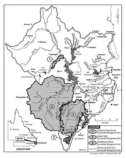
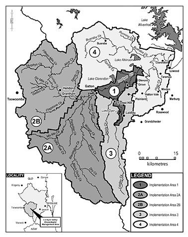
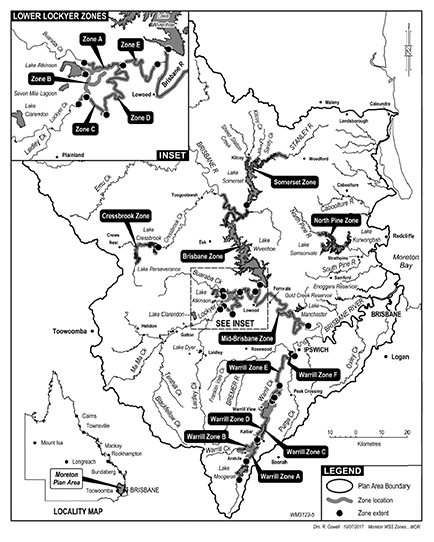
(1)Each part of the plan area that is within a groundwater management area shown on the map in schedule 2 is a groundwater management area for this plan.(2)Each of the following parts of the plan area that is within the Lockyer Valley groundwater management area and shown on the map in schedule 3 is an implementation area for this plan—(a)Central Lockyer Creek (implementation area 1);(b)Upper Lockyer Creek and Flagstone Creek (implementation area 2A);(c)Tenthill Creek and Ma Ma Creek (implementation area 2B);(d)Sandy Creek (parish of Blenheim) and Upper Laidley Creek (implementation area 3);(e)Lower Lockyer Creek and Buaraba Creek (implementation area 4).(3)Implementation areas 2A, 2B, 3 and 4 consist of—(a)alluvial aquifers (groundwater unit 1); and(b)hard rock aquifers (groundwater unit 2).(4)Implementation area 1 consists of groundwater unit 1.s 5 amd 2019 SL No. 251 s 3
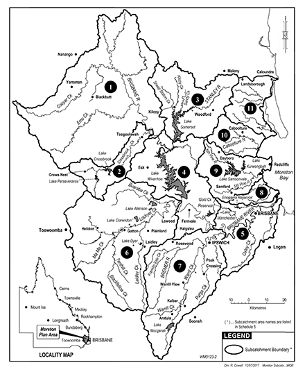
Each part of the plan area that is within a subcatchment area shown on the map in schedule 4, and named in schedule 5, is a subcatchment area for this plan.
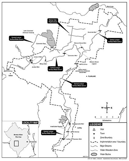
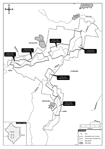
(1)Each zone shown on the map in schedule 5A, part 1 is a trading zone for surface water to which this plan applies, other than surface water in the Central Lockyer Valley water supply scheme.(2)Each zone shown on the map in schedule 5A, part 2 is a trading zone for surface water in the Central Lockyer Valley water supply scheme.(3)Each zone shown on the map in schedule 5A, part 3 is a trading zone for groundwater in the Central Lockyer Valley water supply scheme.(4)A trading zone for surface water includes—(a)each part of a watercourse, lake or spring that is in the zone; and(b)those sections of tributaries from which there is access to flow or pondage from a watercourse or lake in the zone.(5)A trading zone for groundwater includes the part of a groundwater management area that is in the zone.s 6A ins 2017 SL No. 199 s 3
sub 2019 SL No. 251 s 4
(1)The exact location of the boundaries on maps shown in schedules 1 to 4 and 5A is held in digital electronic form by the department.(2)The information held in digital electronic form can be reduced or enlarged to show the details of the boundaries.The boundary locations in digital electronic form may be inspected at the department’s offices at the Gatton Research Station, Warrego Highway, Gatton.s 7 amd 2019 SL No. 251 s 5
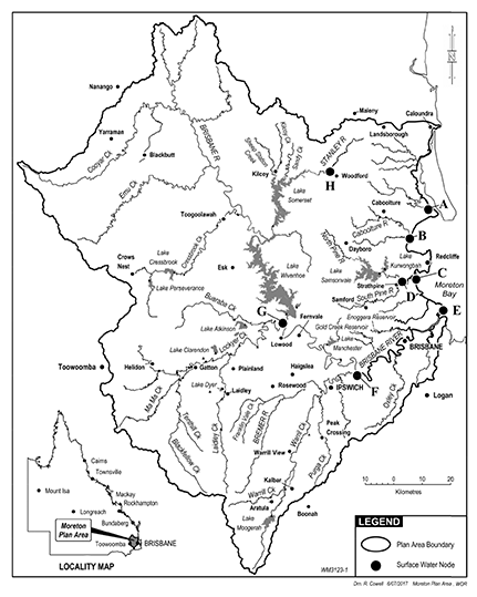
(1)A node mentioned in this plan is a place—(a)on a watercourse in the plan area; and(b)for which environmental flow objectives are set for performance indicators.(2)The location of each node is shown on the map in schedule 1 and described in schedule 6.(3)Each node is identified on the map by a letter.
(1)This plan applies to the following water (surface water) in the plan area—(a)water in a watercourse or lake;(b)water in springs not connected to groundwater.(2)This plan also applies to the following water in the plan area—(a)groundwater, other than groundwater to which the Water Plan (Great Artesian Basin and Other Regional Aquifers) 2017 applies;(b)overland flow water, other than water in springs connected to groundwater.s 9 amd 2017 SL No. 164 s 106
10Outcomes for water in plan area
Water is to be allocated and sustainably managed in a way that—(a)recognises the natural state of watercourses, lakes and springs has changed because of water infrastructure, flow supplementation and the taking of water; and(b)seeks to achieve a balance in the following outcomes—(i)the general outcomes mentioned in section 11;(ii)the ecological outcomes mentioned in section 12.
(1)Each of the following is a general outcome for surface water in the plan area—(a)to provide for additional water to be taken from the plan area for future water requirements;(b)to protect the probability of taking water under water entitlements;(c)to provide options for water users to implement their own provisions for security of supply;(d)to provide for the continued use of all water entitlements and other authorisations to take or interfere with water in the plan area;(e)to encourage the efficient use of water;(f)to ensure water is available for essential services;(g)to achieve ecological outcomes consistent with supporting natural ecosystems by minimising changes to natural flow regimes;(h)to allow water-related cultural use of parts of the plan area by the traditional owners of the area;(i)to provide consistency between this plan and the SEQ regional plan.(2)Each of the following is a general outcome for groundwater in the plan area—(a)to provide for the continued use of all water entitlements and other authorisations to take or interfere with groundwater in the plan area;(b)to encourage the efficient use of the water;(c)to maintain long-term water quality;(d)to protect, as far as practicable, baseflow to watercourses that support natural ecosystems;(e)to allow water-related cultural use of parts of the plan area by the traditional owners of the area;(f)to provide consistency between this plan and the SEQ regional plan.(3)Each of the following is a general outcome for overland flow water in the plan area—(a)to provide for the continued use of existing overland flow works;(b)to encourage the efficient use of the water;(c)to support natural ecosystems by minimising changes to natural flow regimes;(d)to maintain run-off to achieve the general outcomes for surface water;(e)to provide consistency between this plan and the SEQ regional plan.(4)Each of the following is a general outcome for surface water and groundwater in the Central Lockyer Valley water supply scheme—(a)to support long-term agricultural productivity and investment and the financial security of people who use the water for agriculture;(b)to recognise the different contributions that natural recharge and recharge through infrastructure make to the availability of groundwater, to inform future allocations and support agricultural businesses;(c)to increase information held about the water, through the collection and analysis of relevant information about the water, to support future decision making and improvements in this plan;(d)to provide opportunities for initiatives that allow additional water to become available through the coordinated storage, management and delivery of the water, for future agricultural purposes.(5)In this section—relevant information, about water, means—(a)trends in the levels of the groundwater; and(b)the volume of groundwater used; and(c)the recharge characteristics of the groundwater; and(d)the quality of the groundwater.s 11 amd 2019 SL No. 251 s 6
(1)Particular ecological outcomes for water in the part of the plan area stated for the outcome are as follows—(a)for Stanley River and tributaries, upstream of the impounded area of Woodford Weir—(i)to minimise changes to flows that support river-forming processes; and(ii)to minimise changes to the low flow regime;(b)for Boondall Wetlands—to provide freshwater flows necessary to maintain the long-term pattern of inflows to, and ecological functions of, the wetlands;(c)for estuarine reaches—to minimise changes to brackish water habitats;(d)for Moreton Bay and Pumicestone Channel—to minimise changes to the natural movement and delivery of sediment, and the delivery of fresh water, natural nutrients and organic matter.(2)In this section—impounded area, of Woodford Weir, means the area of the weir that is inundated when the weir is at its full supply level.
pt 3A hdg ins 2019 SL No. 251 s 7
12AMeasures that contribute to achieving particular water plan outcomes
(1)Measures that contribute to achieving the water plan outcomes stated in section 11(2) and (4) are—(a)the development, before this plan expires, by the chief executive in consultation with Seqwater and water users, of a new model for the management and allocation of groundwater in groundwater unit 1 in implementation area 1; and(b)the collection and analysis of relevant information about groundwater in the part of groundwater unit 1 in implementation area 1—(i)for groundwater that is not in the Central Lockyer Valley water supply scheme—by the chief executive to help the chief executive make decisions about the sustainable management of groundwater use and the protection of groundwater aquifers in the area mentioned in that subsection; and(ii)for groundwater in the Central Lockyer Valley water supply scheme—by a resource operations licence holder to help the licence holder make decisions about the sustainable management of groundwater use and the protection of groundwater aquifers in the area mentioned in that subsection.(2)The information collected, and analysis of the information, mentioned in subsection (1)(b)(i) is research and monitoring for the Water Regulation 2016, section 22(4)(d).(3)In this section—relevant information, about groundwater, means—(a)trends in the levels of the groundwater; and(b)the volume of groundwater used; and(c)the recharge characteristics of the groundwater; and(d)the quality of the groundwater.s 12A ins 2019 SL No. 251 s 7
pt 4 div 1 hdg om 2019 SL No. 251 s 8
This division applies to surface water.s 13 sub 2019 SL No. 251 ss 8–9
14Performance indicators for environmental flow objectives
The performance indicators for the environmental flow objectives are—(a)for assessing periods of low flow—(i)50% daily flow; and(ii)90% daily flow; and(iii)daily flow less than 1ML; and(iv)number of periods of no flow of at least 1 month but less than 3 months; and(v)number of periods of no flow of at least 3 months but less than 6 months; and(vi)number of periods of no flow of at least 6 months; and(b)for assessing periods of medium to high flow—(i)mean annual flow; and(ii)1.5 year daily flow volume; and(iii)5 year daily flow volume; and(iv)20 year daily flow volume; and(c)for assessing seasonal flow patterns—(i)flow regime class; and(ii)annual proportional flow deviation.
15Environmental flow objectives
The environmental flow objectives for this plan are stated in schedule 7.
This division applies to surface water and groundwater.s 15A ins 2019 SL No. 251 s 10
16Performance indicators for water allocation security objectives
The performance indicators for the water allocation security objectives are—(a)for a water allocation to take supplemented water—the monthly supplemented water sharing index; and(b)for a water allocation to take unsupplemented water in a class A, B, C, D or E water allocation group—70% unsupplemented water sharing index; and(c)for a water allocation to take supplemented groundwater in a zone—the maximum allowable volume for the zone for the water allocation’s priority group.s 16 amd 2019 SL No. 251 s 11
17Water allocation security objectives
The water allocation security objectives for this plan are stated in schedule 8.
18Strategies for surface water
This part—(a)applies to surface water; and(b)states the strategies for achieving the outcomes mentioned in part 3.
pt 5 div 2 hdg amd 2019 SL No. 251 s 12
19Application of div 2
This division applies to decisions about the allocation or management of surface water in the plan area, other than a decision—(a)about reinstating or replacing an expired water licence; or(b)to grant a water entitlement to a local government, government agency or the bulk water supply authority for supply under operations or water infrastructure that were in existence on the commencement of this plan.s 19 amd 2008 Act No. 34 s 751 sch 2; 2017 SL No. 199 s 4; 2019 SL No. 251 s 13
20Decisions about surface water must be consistent with objectives
Decisions about the allocation or management of surface water in the plan area, other than a decision about a water permit, must be consistent with—(a)the environmental flow objectives for surface water stated in schedule 7; and(b)the water allocation security objectives for surface water stated in schedule 8.s 20 amd 2019 SL No. 251 s 14
21Assessing impact of decisions about surface water
(1)The IQQM computer program’s simulation for the simulation period is used to assess consistency with the objectives for surface water.(2)If it is not practicable to use the IQQM computer program, another assessment method approved by the chief executive may be used.(3)The chief executive may approve an assessment method for subsection (2) only if the chief executive is satisfied the method will assess consistency with the objectives at least as accurately as the IQQM computer program.s 21 amd 2019 SL No. 251 s 15
22Decisions about surface water not to increase amount of water taken
(1)The chief executive must not make a decision about the management or allocation of surface water that would increase the average volume of surface water available to be taken in the plan area.(2)Subsection (1) does not apply to a decision—(a)about unallocated water made under section 25; or(b)about a water permit.(3)For subsection (1), a decision includes a decision about an application for an authorisation to take water made but not dealt with before the commencement of this plan.s 22 amd 2008 Act No. 34 s 751 sch 2; 2019 SL No. 251 s 16
23Restriction on taking water from waterholes or lakes
(1)The chief executive may grant an authorisation to take water from a waterhole or lake only if—(a)the chief executive imposes a condition on the authorisation about maintaining the cultural or environmental values of the waterhole or lake; or(b)the chief executive is satisfied the taking of the water will not adversely affect the cultural and environmental values of the waterhole or lake.a condition that the water may be taken only if the water level in the waterhole or lake is above the level that is 0.5m below the level at which the waterhole or lake naturally overflows(2)In making a decision under subsection (1), the chief executive must consider—(a)the impact the proposed taking of the water may have on the following—(i)water quality;(ii)brackish water habitats in estuarine reaches;(iii)inundation of habitats;(iv)the movement of fish and other aquatic species;(v)the natural movement and delivery of sediment, and the delivery of fresh water, natural nutrients or organic matter, to Moreton Bay or Pumicestone Channel;(vi)recreation and aesthetic values;(vii)cultural values including, for example, cultural values of the traditional owners of the area; and(b)whether the proposed taking is likely to have a direct adverse effect on groundwater flows.(3)An authorisation mentioned in subsection (1) does not include a water allocation converted from an authorisation under division 7.(4)Subsection (1) does not limit the restrictions that may be imposed on the taking of water from a waterhole or lake.(5)Subsection (2) does not limit the matters the chief executive may consider.
pt 5 div 3 hdg sub 2019 SL No. 251 s 17
24Unallocated water held as general reserve or strategic reserve
(1)Unallocated water in the plan area is held as a general reserve or strategic reserve and dealt with under this division.(2)For section 43(1)(c) of the Act, the volume of unallocated water held as reserves under subsection (1) is 100ML.s 24 sub 2019 SL No. 251 s 17
24AProcesses for releasing unallocated water—Act, s 43
(1)For section 43(2)(f) of the Act, the processes for releasing unallocated water reserved under this division are the processes stated in the Water Regulation 2016, part 2, division 2, subdivision 2.(2)In preparing and implementing a process for releasing unallocated water under subsection (1), the chief executive must consider the matters stated in the water management protocol.s 24A ins 2019 SL No. 251 s 17
(1)Unallocated water may be granted only—(a)for infrastructure for a project declared under the State Development and Public Works Organisation Act 1971, section 26, to be a coordinated project; or(b)for infrastructure identified for—(i)the SEQ regional plan; or(ii)a regional water security program; or(c)for a community facility; or(d)for a small scale commercial enterprise; or(e)under a process in the water management protocol.(2)In this section—community facility includes—(a)a public recreational facility; or(b)a sporting facility; or(c)another facility used by a not for profit organisation.s 25 amd 2017 SL No. 199 s 5; 2019 SL No. 251 s 18
26Matters chief executive must consider
(1)In dealing with unallocated water, the chief executive must consider—(a)the need for, and efficiency of, current and proposed uses of water including—(i)the extent to which water is being taken under authorisations in the plan area; and(ii)emerging requirements for additional water, in and outside the plan area, and the likely timeframe in which the additional water will be required; and(iii)alternative water sources including, for example, recycled water and water savings from improvements in the efficiency of water use; and(b)the availability of an alternative water supply for the purpose for which the water is required; and(c)the impact the proposed taking of or interfering with the water may have on the following—(i)water quality;(ii)brackish water habitats in estuarine reaches;(iii)inundation of habitats;(iv)the movement of fish and other aquatic species;(v)the natural movement and delivery of sediment, and the delivery of fresh water, natural nutrients or organic matter, to Moreton Bay or Pumicestone Channel;(vi)recreation and aesthetic values;(vii)cultural values, including, for example, cultural values of the traditional owners of the area; and(d)whether the proposed taking or interfering with, or the proposed use of, the water is likely to—(i)have a direct adverse effect on groundwater; or(ii)lead to degradation, including salinity, of land or downstream watercourses; and(e)whether the proposed use of the water is consistent with—(i)the SEQ regional plan; and(ii)any system operating plan applying to the plan area; and(iii)any regional water security program for the SEQ region.(2)Subsection (1) does not limit the matters the chief executive may consider.
pt 5 div 4 hdg om 2019 SL No. 251 s 19
pt 5 div 4 sdiv 1 hdg om 2019 SL No. 251 s 19
s 27 amd 2017 SL No. 199 s 6
pt 5 div 4 sdiv 2 hdg om 2019 SL No. 251 s 19
s 28 om 2019 SL No. 251 s 19
s 29 om 2019 SL No. 251 s 19
s 30 om 2019 SL No. 251 s 19
s 31 om 2019 SL No. 251 s 19
pt 5 div 4 sdiv 3 hdg om 2019 SL No. 251 s 19
s 32 om 2019 SL No. 251 s 19
s 33 om 2019 SL No. 251 s 19
s 34 om 2019 SL No. 251 s 19
pt 5 div 4 sdiv 4 hdg om 2019 SL No. 251 s 19
s 35 om 2019 SL No. 251 s 19
36Water entitlements to be managed under resource operations licences
Water allocations for the following water supply schemes are to be managed under the resource operations licence for the scheme—(a)Central Lockyer Valley water supply scheme;(b)Lower Lockyer Valley water supply scheme;(c)Warrill Valley water supply scheme.s 36 amd 2008 Act No. 34s 751sch 2
sub 2014 SL No. 142s 185
37Deciding operating arrangements and supply requirements
(1)In deciding the operating arrangements and supply requirements for water infrastructure and proposed water infrastructure under the resource operations licence for each water supply scheme mentioned in section 36, the chief executive must consider—(a)the impact of the infrastructure’s or proposed infrastructure’s operation on the following—(i)the water allocation security objectives;(ii)water quality;(iii)brackish water habitats in estuarine reaches;(iv)instream water levels;(v)erosion of the bed and banks of watercourses;(vi)riparian vegetation;(vii)the extent to which artificial variations in instream water levels and flows may adversely affect natural ecosystems;(viii)recreation and aesthetic values of the plan area;(ix)cultural values, including, for example, cultural values of the traditional owners of the plan area; and(b)the impact of the infrastructure or proposed infrastructure on the movement of fish and other aquatic species; and(c)the impact of the transfer of water between watercourses; and(d)the likelihood of fish deaths caused by the operation of the infrastructure; and(e)the joint operation of existing and proposed infrastructure; and(f)any system operating plan applying to the plan area; and(g)any regional water security program for the SEQ region.(2)Subsection (1) does not limit the matters the chief executive may consider.s 37 amd 2014 SL No. 142s 186
pt 5 div 6 sdiv 1 hdg om 2014 SL No. 142s 187
pt 5 div 6 sdiv 2 hdg om 2014 SL No. 142s 188
38Authorising existing taking of water from Morton Vale Pipeline zone
(1)The chief executive must grant 2 water allocations to the bulk water supply authority to take surface water from the Morton Vale Pipeline zone.(2)The first water allocation—(a)must state a nominal volume of 3,507ML; and(b)belongs to the medium priority B group.(3)The second water allocation—(a)must state a nominal volume of 185ML; and(b)belongs to the high priority group.s 38 prev s 38 om 2014 SL No. 142 s 187
pres s 38 ins 2019 SL No. 251 s 20
39Matters for chief executive to consider
(1)This section applies to the chief executive in deciding the water allocation dealing rules to be included in the water management protocol for the water allocation granted under section 38(1).(2)The chief executive must consider existing water use agreements and supply contracts between the bulk water supply authority and water users.(3)Subsection (2) does not limit the matters the chief executive may consider.s 39 prev s 39 om 2014 SL No. 142 s 187
pres s 39 ins 2019 SL No. 251 s 20
This division states, for section 43(2)(g) of the Act, the arrangements and process for converting, under a water entitlement notice for this plan, particular authorisations to water allocations.s 40 prev s 40 amd 2008 Act No. 34s 751 sch 2
om 2014 SL No. 142 s 188
pres s 40 ins 2019 SL No. 251 s 21
41Authorisations may be converted to water allocations
A water entitlement notice may, under section 70(1)(a) of the Act, implement this plan by providing for an authorisation to take surface water from the Central Lockyer Valley water supply scheme to be converted to a water allocation to take surface water from the Central Lockyer Valley water supply scheme.s 41 prev s 41 amd 2008 Act No. 34 s 751 sch 2
om 2014 SL No. 142 s 188
pres s 41 ins 2019 SL No. 251 s 21
s 42 amd 2017 SL No. 199 s 7
s 43 sub 2014 SL No. 142 s 190
amd 2017 SL No. 199 s 8
The location for taking water stated on a water allocation must include the place at which water could have been taken under the authorisation.
45Purpose to be stated on water allocation
The purpose stated on a water allocation must be—(a)if the purpose stated on the authorisation is ‘distribution loss’—‘distribution loss’; or(b)otherwise—‘any’.
46Nominal volume for water allocation
The nominal volume for a water allocation to take supplemented water is—(a)if the authorisation states an annual volume—the stated volume; or(b)if the authorisation is an interim water allocation to take supplemented water in the Central Lockyer Valley water supply scheme that states an area that may be irrigated—the volume decided by the chief executive having regard to the volume of water required to efficiently irrigate the area, but not more than the volume, expressed in megalitres, calculated by multiplying the area, in hectares, by 3.4.
(1)In the Central Brisbane River, Pine Valleys and Stanley River water supply schemes, a water allocation to take supplemented water belongs to—(a)for an authorisation to take water that states a volumetric limit—the medium priority group; and(b)for an authorisation to take water for water harvesting purposes in the Central Brisbane River water supply scheme—the medium priority group; and(c)for other authorisations—the high priority A group.(2)In the Central Lockyer Valley water supply scheme, a water allocation to take surface water belongs to—(a) for a water allocation to take surface water from the Morton Vale Pipeline zone—the medium priority B group or the high priority group; or(b)for a water allocation to take surface water from a zone other than the Morton Vale Pipeline zone—the medium priority C group.(3)In the Cressbrook Creek water supply scheme, a water allocation to take supplemented water belongs to the high priority A group.(4)In the Lower Lockyer Valley water supply scheme, a water allocation to take supplemented water belongs to the medium priority group.(5)In the Warrill Valley water supply scheme, a water allocation to take supplemented water belongs to the medium priority group.(6)In the Caboolture River, a water allocation to take supplemented water belongs to the high priority B group.s 47 amd 2008 SL No. 362s 3; 2019 SL No. 251 s 22
48Elements of a water allocation
A water allocation to take unsupplemented water must state—(a)the maximum rate at which water may be taken under the allocation; and(b)the annual volumetric limit for the allocation.s 48 sub 2014 SL No. 142s 191
49Nominal volume for water allocation
In deciding the nominal volume for a water allocation to take unsupplemented water, the chief executive—(a)must consider, for each authorisation—(i)the local availability of water; and(ii)the conditions under which water may be taken under the authorisation; and(iii)the volume of water required to efficiently irrigate the area being irrigated under the authorisation; and(iv)the water taking capacity of any works, in existence on the commencement of this plan, for taking water under the authorisation; and(v)the annual volumes of water estimated by the chief executive to have been taken under the authorisation during the period, of not more than 10 years, immediately before the commencement of this plan; and(vi)the efficiency of the use of the water mentioned in subparagraph (v); and(b)must ensure the following—(i)for all authorisations in a class A water allocation group in a subcatchment area mentioned in schedule 10, column 1—the simulated mean annual diversion for the water allocation group is not more than the volume stated in column 2 of the schedule for the subcatchment area;(ii)for all authorisations in a class B water allocation group in a subcatchment area mentioned in schedule 10, column 1—the simulated mean annual diversion for the water allocation group is not more than the volume stated in column 3 of the schedule for the subcatchment area;(iii)for all authorisations in a class C water allocation group in a subcatchment area mentioned in schedule 10, column 1—the simulated mean annual diversion for the water allocation group is not more than the volume stated in column 4 of the schedule for the subcatchment area;(iv)for all authorisations in a class D water allocation group in a subcatchment area mentioned in schedule 10, column 1—the simulated mean annual diversion for the water allocation group is not more than the volume stated in column 5 of the schedule for the subcatchment area;(v)for all authorisations in a class E water allocation group in a subcatchment area mentioned in schedule 10, column 1—the simulated mean annual diversion for the water allocation group is not more than the volume stated in column 6 of the schedule for the subcatchment area.
50Annual volumetric limit for water allocation
(1)The annual volumetric limit for a water allocation to take unsupplemented water is—(a)if the authorisation states an annual volume of water—the stated volume; and(b)if the authorisation does not state an annual volume of water—the volume decided by the chief executive having regard to—(i)the conditions under which water may be taken under the authorisation; and(ii)the water taking capacity of any works, being used or authorised to be used, for taking water under the authorisation; and(iii)the annual volumes of water estimated by the chief executive to have been taken under the authorisation during the period, of not more than 10 years, immediately before the commencement of this plan; and(iv)the efficiency of the use of the water mentioned in subparagraph (iii).(2)Subsection (1)(b) does not limit the matters the chief executive may consider.
s 51 om 2014 SL No. 142s 192
The maximum rate at which unsupplemented water may be taken under a water allocation is—(a)if the authorisation states a maximum rate—the stated rate; and(b)if the authorisation does not state a maximum rate but a related development permit states a pump size mentioned in schedule 11, column 1—(i)if the authorisation holder satisfies the chief executive that the actual rate at which water can be taken is different from the rate stated in schedule 11, column 2, for the pump size—the rate decided by the chief executive having regard to—(A)the conditions under which water may be taken; and(B)the water taking capacity of the pump to which the development permit relates (the existing pump) under normal operating conditions; and(C)the irrigation or water distribution system related to the existing pump during the period of not more than 10 years immediately before the commencement of this plan; and(D)the efficiency of the irrigation or water distribution system mentioned in subsubparagraph (C); or(ii)otherwise—the rate stated in schedule 11, column 2, for the pump size; and(c)if the authorisation does not state a maximum rate but a related development permit states a pump size other than a pump size mentioned in schedule 11, column 1—the rate decided by the chief executive having regard to the matters mentioned in paragraph (b)(i)(A) to (D); and(d)if paragraphs (a) to (c) do not apply—the rate decided by the chief executive having regard to—(i)the nature of the authorisation; and(ii)an estimate of the rate, or measurement of the actual rate, at which water is taken under the authorisation.
In deciding the conditions under which water may be taken under a water allocation to take unsupplemented water, the chief executive must have regard to the conditions stated on the authorisation.
A water allocation to take unsupplemented water belongs to—(a)for an authorisation, or part of an authorisation, to take water for irrigation purposes or that the chief executive decides is for irrigation purposes—a class A water allocation group; or(b)for an authorisation to take unsupplemented water in any of the following areas—a class B water allocation group—(i)Central Brisbane River water supply scheme;(ii)Central Lockyer Valley water supply scheme;(iii)Lower Lockyer Valley water supply scheme;(iv)Pine Valleys water supply scheme;(v)Stanley River water supply scheme;(vi)Warrill Valley water supply scheme; or(c)for an authorisation to take unsupplemented water other than from a water supply scheme for water harvesting purposes or that the chief executive decides is for water harvesting purposes—a class C water allocation group; or(d)for an authorisation for town water supply purposes—a class D water allocation group; or(e)for any other authorisation—a class E water allocation group.
A water licence to take unsupplemented water must state—(a)an annual volumetric limit; and(b)the maximum rate at which water may be taken under the water licence during a particular period of time or in particular circumstances; and(c)a purpose of ‘any’.s 55 amd 2019 SL No. 251 s 23
(1)This section applies to a water licence to take unsupplemented water in force on the commencement of this plan.(2)The licence may be amended to state the following—(a)the purpose for which water may be taken under the licence;(b)the annual volumetric limit for the licence;(c)the maximum rate at which water may be taken under the licence;(d)the flow conditions for the licence;(e)any other conditions decided by the chief executive.s 56 amd 2014 SL No. 142 s 193; 2017 SL No. 199 s 9
57Annual volumetric limit for water licence
The annual volumetric limit to take unsupplemented water for a water licence mentioned in section 56(1) is the annual volumetric limit mentioned in section 50 or decided by the chief executive under that section as if the water licence were a water allocation.s 57 sub 2014 SL No. 142s 194
The maximum rate at which unsupplemented water may be taken under a water licence mentioned in section 56(1) is the maximum rate mentioned in section 52 or decided by the chief executive under that section as if the water licence were a water allocation.s 58 sub 2014 SL No. 142s 194
61Releasing water through fish ways
If water to which this plan applies can be released from a dam or weir through fish ways, each resource operations licence must include environmental management rules for the release of the water.s 61 amd 2017 SL No. 199 s 10
This part—(a)applies only to groundwater; and(b)states the strategies for achieving the outcomes mentioned in part 3.
pt 6 div 1A hdg ins 2019 SL No. 251 s 24
This division applies to decisions about the allocation or management of groundwater to which this plan applies.s 62A ins 2019 SL No. 251 s 24
62BDecision about groundwater to be consistent with objectives
A decision about the allocation or management of groundwater to which this plan applies, other than a decision about a water permit, must be consistent with the water allocation security objectives stated in section 17.s 62B ins 2019 SL No. 251 s 24
63Limitation on taking groundwater—Act, s 101
A person may not take groundwater in the Cressbrook Creek alluvial groundwater management area (the management area) other than—(a)for stock or domestic purposes; or(b)under a water entitlement or water permit; or(c)to allow monitoring or salinity control.s 63 amd 2013 Act No. 23 s 352 sch 1 pt 2; 2017 SL No. 199 s 11
64Decisions about taking groundwater
(1)The chief executive must not make a decision, about the allocation or management of groundwater in the management area, that would increase the average volume of groundwater that may be taken in the management area.(2)A decision mentioned in subsection (1) includes a decision about an application for a water licence, made but not decided before the commencement of this plan.(3)Subsections (1) and (2) do not apply to a decision—(a)about a water permit; or(b)about reinstating or replacing an expired water licence; or(c)about water sharing rules.s 64 amd 2017 SL No. 199 s 12
65Amending water licences to take groundwater
(1)This section applies to a water licence to take groundwater in force on the commencement of this plan.(2)The chief executive may amend the water licence to state—(a)an annual volumetric limit for the licence; and(b)any other condition decided by the chief executive.(3)In deciding the annual volumetric limit for a water licence, the chief executive must have regard to—(a)the water taking capacity of any works, in existence on the commencement of this plan, for taking water under the water licence; and(b)the annual volumes of groundwater estimated by the chief executive to have been taken during the period, of not more than 10 years, immediately before the commencement of this plan; and(c)the efficiency of the use of the water mentioned in paragraph (b); and(d)the impact the taking of groundwater under the water licence has on the flow of surface water; and(e)data collected by the chief executive about groundwater levels; and(f)whether the amount of water to be taken under the water licence is consistent with the outcomes mentioned in part 3 and the objectives of this plan.s 65 amd 2017 SL No. 199 s 13
66Limitation on taking groundwater—Act, s 101
A person may not take groundwater in the Lockyer Valley groundwater management area (the management area) other than—(a)for stock or domestic purposes; or(b)under a water entitlement or water permit; or(c)to allow monitoring or salinity control; or(d)under an authorisation under section 72.s 66 amd 2013 Act No. 23 s 352 sch 1 pt 2; 2017 SL No. 199 s 14
67Decisions about taking groundwater
(1)The chief executive must not make a decision, about the allocation or management of groundwater in the management area, that would increase the average volume of groundwater that may be taken in the management area.(2)A decision mentioned in subsection (1) includes a decision about an application for a water licence, made but not decided before the commencement of this plan.(3)Subsections (1) and (2) do not apply to a decision—(a)about a water permit; or(b)about reinstating or replacing an expired water licence; or(c)about water sharing rules.s 67 amd 2017 SL No. 199 s 15
68Supplemented and unsupplemented groundwater areas
(1)Groundwater unit 1 in implementation area 1 consists of—(a)the supplemented groundwater area; and(b)the unsupplemented groundwater area.See subdivision 4 (Water sharing rules) for the process for managing groundwater in the unsupplemented groundwater area.(2)The supplemented groundwater area is supplemented by the release of surface water from the Central Lockyer Valley water supply scheme.
s 69 om 2017 SL No. 199 s 16
pt 6 div 3 sdiv 3 hdg amd 2019 SL No. 251 s 25
70Implementation areas 2A, 2B and 3
Groundwater unit 1 in implementation area 2A, 2B or 3 consists of the unsupplemented groundwater area.See subdivision 4 (Water sharing rules) for the process for managing groundwater in the unsupplemented groundwater area.s 70 amd 2019 SL No. 251 s 26
s 71 om 2017 SL No. 199 s 17
72Continued taking of groundwater authorised
(1)An owner of land in implementation area 2A, 2B, 3 or 4 who, on the commencement of this plan, is using an existing water bore on the land to take groundwater may continue to take groundwater using the bore.(2)If the chief executive is reasonably satisfied the outcomes mentioned in part 3 or the objectives mentioned in part 4 are not being achieved, the chief executive may, under section 116 of the Act, grant a water licence to the owner to take groundwater using the bore.(3)The water licence must state an annual volumetric limit for the licence.s 72 amd 2017 SL No. 199 s 18; 2019 SL No. 251 s 27
(1)This section applies if, under section 36 of the Act, a chief executive’s notice requires the owner of land in implementation area 2A, 2B, 3 or 4 on which there are existing works for taking water to notify the chief executive of the works and the water use.(2)After the chief executive receives the notice, the chief executive may, under section 116 of the Act, grant a water licence to the owner to continue to take groundwater using the works.(3)For groundwater unit 2, the water licence must state an annual volumetric limit for the licence.(4)In deciding the annual volumetric limit for the water licence for groundwater unit 2, the chief executive must have regard to—(a)the water taking capacity of the works; and(b)the annual volume of groundwater estimated by the chief executive to have been taken during the period, of not more than 10 years, immediately before the commencement; and(c)the efficiency of the use of the water mentioned in paragraph (b); and(d)data collected by the chief executive about groundwater levels; and(e)whether the amount of water to be taken under the licence is consistent with the outcomes mentioned in part 3 and the objectives of this plan.s 73 amd 2011 Act No. 40 s 107 sch; 2017 SL No. 199 s 19; 2019 SL No. 251 s 28
74Water sharing rules for unsupplemented groundwater
(1)The water management protocol must contain water sharing rules for the unsupplemented groundwater in groundwater unit 1 in the management area.(2)In developing the water sharing rules for the management area, the chief executive must consult with water users and water service providers in the area.s 74 amd 2017 SL No. 199 s 20
75Amending water licences to state an annual volumetric limit
(1)This section applies if the chief executive is reasonably satisfied the water sharing rules for an implementation area are not achieving the outcomes mentioned in part 3 or the objectives of this plan.(2)The chief executive may amend the water licences in the implementation area to state annual volumetric limits for the licences.s 75 amd 2017 SL No. 199 s 21
76Limitation on taking groundwater—Act, s 101
A person may not take groundwater in the Warrill-Bremer alluvial groundwater management area (the management area) other than—(a)for stock or domestic purposes; or(b)under a water entitlement or water permit; or(c)to allow monitoring or salinity control; or(d)under an authorisation under section 78.s 76 amd 2013 Act No. 23 s 352 sch 1 pt 2; 2017 SL No. 199 s 22
77Decisions about taking groundwater
(1)The chief executive must not make a decision, about the allocation or management of groundwater in the management area, that would increase the average volume of groundwater that may be taken in the management area.(2)Subsection (1) does not apply to a decision—(a)about a water permit; or(b)about water sharing rules; or(c)about taking groundwater for an allowable urban purpose.s 77 amd 2017 SL No. 199 s 23
78Continued taking of groundwater authorised
(1)An owner of land in the management area who, on the commencement of this plan, is using an existing water bore on the land to take groundwater may continue to take groundwater using the bore.(2)If the chief executive is reasonably satisfied the outcomes mentioned in part 3 or the objectives mentioned in part 4 are not being achieved, the chief executive may, under section 116 of the Act, grant a water licence to the owner to take groundwater using the bore.(3)The water licence must state an annual volumetric limit for the licence.s 78 amd 2017 SL No. 199 s 24
(1)This section applies if, under section 36 of the Act, a chief executive’s notice requires the owner of land who is authorised under section 78(1) to take groundwater using an existing water bore to notify the chief executive of the bore and the water use.(2)After the chief executive receives the notice, the chief executive may, under section 116 of the Act, grant a water licence to the owner to take groundwater using the bore.(3)In deciding the annual volumetric limit for the licence, the chief executive must have regard to—(a)the water taking capacity of the bore; and(b)the annual volume of groundwater estimated by the chief executive to have been taken during the period, of not more than 10 years, immediately before the commencement; and(c)the efficiency of the use of the water mentioned in paragraph (b); and(d)the impact on surface water flows; and(e)data collected by the chief executive about groundwater levels; and(f)whether the amount of water to be taken under the licence is consistent with the outcomes mentioned in part 3 and the objectives of this plan.s 79 amd 2011 Act No. 40 s 107 sch; 2017 SL No. 199 s 25
80Granting water licence to take groundwater for allowable urban purpose
(1)The chief executive may grant a water licence to take groundwater for an allowable urban purpose using a bore.(2)The maximum rate at which groundwater may be taken under the water licence is 5L/sec.
81Boundaries of watercourse buffer zone
The watercourse buffer zone groundwater management area (the watercourse buffer zone) consists of, for each watercourse or lake mentioned in schedule 12, column 1—(a)the reach of the watercourse or lake stated in column 2 of the schedule; and(b)the area between the high bank of the watercourse or lake and the setback distance stated in column 3 of the schedule.
82Limitation on taking groundwater—Act, s 101
A person may not take groundwater in the watercourse buffer zone other than—(a)for stock or domestic purposes; or(b)to allow monitoring or salinity control; or(c)under an authorisation under section 83.s 82 amd 2013 Act No. 23 s 352 sch 1 pt 2; 2017 SL No. 199 s 26
83Continued taking of groundwater authorised
The owner of land in the watercourse buffer zone on which an existing water bore is situated may continue to take groundwater using the bore.
pt 6 div 6 hdg sub 2019 SL No. 251 s 29
pt 6 div 6 sdiv 1 hdg ins 2019 SL No. 251 s 29
This division states, for section 43(2)(g) of the Act, the arrangements and process for converting, under a water entitlement notice for this plan, particular water licences to water allocations.s 84 prev s 84 amd 2009 SL No. 280s 195; 2014 Act No. 29s 158
om 2016 SL No. 216 s 146 sch 20
pres s 84 ins 2019 SL No. 251 s 29
In this division—additional irrigable area see section 84M.irrigable area see section 84K.preliminary irrigable area see section 84L.relevant period means the period that starts on 1 July 2007 and ends on 30 June 2018.s 84A ins 2019 SL No. 251 s 29
pt 6 div 6 sdiv 2 hdg ins 2019 SL No. 251 s 29
84BWater licences may be converted to water allocations
(1)This section applies to a water licence to take supplemented groundwater from the Central Lockyer Valley water supply scheme for a purpose other than stock purposes or domestic purposes.(2)A water entitlement notice may, under section 70(1)(a) of the Act, implement this plan by providing for 1 or more of the water licences to be converted to 1 or more water allocations to take supplemented groundwater from the Central Lockyer Valley water supply scheme.s 84B ins 2019 SL No. 251 s 29
The location from which water may be taken under a water allocation converted from 1 or more water licences must be a location—(a)from which water could have been taken under—(i)for a water allocation converted from 1 water licence—the water licence; or(ii)for a water allocation converted from more than 1 water licence—only 1 of the water licences; and(b)that is in a trading zone for groundwater.s 84C ins 2019 SL No. 251 s 29
84DNominal volumes for water allocations for water licences held by particular regional councils
(1)The nominal volume for the water allocation converted from water licence 401310 held by the Lockyer Valley Regional Council is 60ML.(2)The nominal volume for the water allocation converted from water licences 66442G and 98268G held by the Lockyer Valley Regional Council is 10ML.s 84D ins 2019 SL No. 251 s 29
84ENominal volumes—1 licence converted to 2 water allocations
(1)This section applies if 1 water licence is converted to 2 water allocations (the first water allocation and the second water allocation respectively).(2)The nominal volume for the first water allocation is the volume, in megalitres, calculated by multiplying the irrigable area for the water licence by 2.(3)The nominal volume for the second water allocation is the volume, in megalitres, calculated by multiplying the irrigable area for the water licence by 4.s 84E ins 2019 SL No. 251 s 29
84FNominal volumes—2 or more licences converted to 2 water allocations
(1)This section applies if 2 or more water licences are converted to 2 water allocations (the first water allocation and the second water allocation respectively).(2)The nominal volume for the first water allocation is the volume, in megalitres, calculated by multiplying the combined irrigable area for the water licences by 2.(3)The nominal volume for the second water allocation is the volume, in megalitres, calculated by multiplying the combined irrigable area for the water licences by 4.(4)In this section—combined irrigable area, for water licences, means the sum of the irrigable areas for the water licences.s 84F ins 2019 SL No. 251 s 29
84GNominal volume—rounding down
If the nominal volume for a water allocation worked out under section 84E or 84F is not a whole number, the nominal volume for the water allocation must be rounded down to the nearest whole number.s 84G ins 2019 SL No. 251 s 29
(1)A water allocation with a nominal volume decided under section 84E(2) or 84F(2) belongs to the medium priority A group.(2)A water allocation with a nominal volume decided under section 84E(3) or 84F(3) belongs to the low priority group.s 84H ins 2019 SL No. 251 s 29
84IPurpose to be stated for taking water
The purpose to be stated for taking water under a water allocation converted from a water licence must be—(a)for a water allocation mentioned in section 84D—‘urban’; or(b)otherwise—‘any’.s 84I ins 2019 SL No. 251 s 29
84JManagement of water allocations
Water allocations converted from water licences under this division are managed under the resource operations licence for the Central Lockyer Valley water supply scheme.s 84J ins 2019 SL No. 251 s 29
pt 6 div 6 sdiv 3 hdg ins 2019 SL No. 251 s 29
The irrigable area for a water licence is the area, in hectares, that is the total of—(a)the preliminary irrigable area for the water licence worked out under section 84L; and(b)if an additional irrigable area for the water licence is worked out under section 84M—the area worked out.The irrigable area for a water licence is held in digital electronic form by the department and can be made available on request to the chief executive.s 84K ins 2019 SL No. 251 s 29
84LWorking out preliminary irrigable area
(1)This section applies in relation to the land attached to a water licence on the commencement.(2)The preliminary irrigable area for the water licence is the area, in hectares, that is the sum of each of the following parts of the land—(a)if the licence allows the whole of a parcel of land to be irrigated using water taken under the licence—the part of the land that the chief executive decides, having considered geological mapping and spatial imagery of the land, is—(i)land with alluvium; or(ii)land without alluvium that has been irrigated, during the relevant period, using water taken under the licence from the land;(b)if the licence allows only a part of a parcel of land to be irrigated using water taken under the licence—the part of the land.(3)However, the preliminary irrigable area for the water licence does not include the area of any part of the land attached to the water licence that has been included in the preliminary irrigable area of another water licence.s 84L ins 2019 SL No. 251 s 29
84MWorking out additional irrigable area
(1)This section applies if—(a)the holder of a water licence to which section 84B applies makes a submission under the Act, section 72 about the draft water entitlement notice mentioned in section 84B; and(b)the submission states that—(i)land (the relevant land), owned by the licence holder but not attached to the water licence, was irrigated during the relevant period using groundwater taken from land attached to the water licence; and(ii)the groundwater was taken from the Central Lockyer Valley water supply scheme using works located on land attached to the water licence; and(iii)the groundwater was conveyed to the relevant land using a pipeline or channel; and(c)the area of the relevant land has not been included in the additional irrigable area for another water licence.(2)The additional irrigable area for the water licence is the total area, in hectares, of the relevant land, or the part of the relevant land, that the chief executives decides was irrigated during the relevant period in the way described in subsection (1)(b).s 84M ins 2019 SL No. 251 s 29
85Applications for water licences to take overland flow water must not be accepted
For section 43(2)(j) of the Act, the chief executive must not accept an application for a water licence to take overland flow water made under section 107 of the Act.s 85 amd 2013 Act No. 23 s 352 sch 1 pt 2; 2017 SL No. 103 s 167; 2017 SL No. 199 s 27
sub 2019 SL No. 251 s 30
86Limitation on taking overland flow water—Act, s 101
(1)For section 101(1) of the Act, a person must not take overland flow water to which this plan applies under section 101(1)(b) of the Act, unless the water is taken—(a)for stock or domestic purposes; or(b)under a water licence; or(c)for another purpose using works that have a capacity of not more than 5ML; or(d)for a purpose the chief executive reasonably considers is for water sensitive urban design; or(e)to satisfy the requirements of—(i)an environmental authority under the Environmental Protection Act 1994; or(ii)a development permit for carrying out an environmentally relevant activity, other than a mining activity or petroleum activity, under the Environmental Protection Act 1994; or(f)under an authority under section 87.(2)For subsection (1)(e), the volume of overland flow water taken must not be more than the amount necessary to satisfy the requirements of the environmental authority or development permit.(3)In this section—water sensitive urban design means urban planning or design that includes integrated water cycle management.s 86 sub 2019 SL No. 251 s 30
87Taking water using particular existing overland flow works authorised
(1)This section applies to the owner of land on which existing overland flow works are situated, other than works for only taking water that may be taken under section 86(1)(a) to (e).(2)The owner is authorised to continue to use the existing overland flow works to take overland flow water.s 87 amd 2011 Act No. 40 s 107 sch; 2017 SL No. 199 s 28
sub 2019 SL No. 251 s 30
88Notification of reconfiguration of existing overland flow works
(1)This section applies to an owner of land authorised to use existing overland flow works to take overland flow water under section 87.(2)If the owner reconfigures the works, the owner must give the chief executive notice, in the approved form, about the reconfiguration.(3)If the owner gives the notice mentioned in subsection (2) to the chief executive, and any further information the chief executive reasonably requires, the owner may continue to use the works to take overland flow water.s 88 prev s 88 amd 2009 SL No. 280s 196; 2011 Act No. 40s 107 sch
om 2016 SL No. 216 s 146 sch 20
pres s 88 ins 2019 SL No. 251 s 30
pt 8 hdg prev pt 8 hdg om 2014 SL No. 142 s 196
pres pt 8 hdg ins 2019 SL No. 251 s 30
89Accounting period for resource operations licences—Water Regulation 2016, s 142
For the Water Regulation 2016, section 142(a), the accounting period for a resource operations licence to take water from the Central Lockyer Valley water supply scheme is 1 January to 31 December.s 89 prev s 89 om 2014 SL No. 142 s 196
pres s 89 ins 2019 SL No. 251 s 30
pt 9 hdg sub 2014 SL No. 142s 197
90Monitoring and reporting requirements
(1)To help the Minister assess the effectiveness of the management strategies for achieving the outcomes mentioned in part 3, the water management protocol must state—(a)the monitoring requirements for water and natural ecosystems for this plan; and(b)the reporting requirements for this plan for operators of infrastructure interfering with water in the plan area.(2)Also, a monitoring requirement for this plan is to monitor the pressure and levels of groundwater in the plan area.(3)Subsections (1) and (2) do not limit the monitoring requirements the chief executive may impose for this plan.s 90 sub 2014 SL No. 142 s 197
amd 2017 SL No. 199 s 29
s 91 sub 2014 SL No. 142s 197
om 2016 SL No. 216 s 146 sch 20
s 92 om 2014 SL No. 142s 197
s 93 om 2014 SL No. 142s 197
94Priority areas for converting to, or granting, water allocations
Each area described in schedule 13 is a priority area for this plan for the conversion to, or granting of, water allocations to take water in the plan area.
(1)This section states the proposed arrangements for implementing this plan.(2)Within 4 years after the commencement, it is proposed to amend this plan—(a)to convert authorisations in the priority area to water allocations; and(b)to deal with unallocated surface water available for future water requirements in the priority area.(3)Within 4 years after the commencement, it is proposed to amend—(a)the water management protocol to make water allocation change rules; and(b)each resource operations licence that relates to the priority area—(i)to make environmental management rules; and(ii)to implement the monitoring requirements in part 9 for the priority area; and(c)the operations manual required under each resource operations licence that relates to the priority area to make—(i)water sharing rules; and(ii)seasonal water assignment rules.(4)Subsections (2) and (3) do not limit the matters that may be included in the water management protocol.s 95 sub 2017 SL No. 199 s 30
96Minor or stated amendment of plan—Act, s 51
The following types of amendment may be made to this plan under section 51(2)(a) of the Act—(a)an amendment or addition of an environmental flow objective if the amendment or addition achieves an equivalent or improved ecological outcome without adversely affecting the water allocation security objectives or the outcomes under part 3;(b)an amendment or addition of a water allocation security objective if the amendment or addition does not adversely affect existing water allocations, environmental flow objectives or the outcomes under part 3;(c)an amendment or addition of a priority area;(d)an amendment or addition of a node;(e)an amendment or addition of a priority group;(f)an amendment or addition of a water allocation group;(g)an amendment to subdivide a subcatchment area or amalgamate subcatchment areas;(h)an amendment to the boundary of a groundwater management area;(i)an amendment to the boundary of an implementation area;(j)an amendment to subdivide an implementation area or amalgamate implementation areas;(k)an amendment to the boundary, or the addition, of a watercourse buffer zone;(l)an amendment to subdivide a volume, or amalgamate volumes, stated in schedule 10;(m)an amendment of the type of water entitlement that may be granted for town water supply purposes;(n)an amendment or addition of a monitoring or reporting requirement under part 9.s 96 amd 2017 SL No. 199 s 31; 2019 SL No. 251 s 31
The Minister must consider amending this plan or preparing a new plan to replace this plan if the Minister is satisfied—(a)in relation to the outcomes mentioned in part 3—(i)water entitlements in the plan area are not sufficient to meet water needs sourced from the plan area having regard to—(A)the extent to which water is being taken under the water entitlements; and(B)the efficiency of present, and expected future, water use; and(C)emerging requirements for additional water; and(D)alternative water sources including, for example, recycled water and water savings from improvements in the efficiency of water use; and(E)the likely timeframe in which additional water will be required; and(ii)there are economically viable and ecologically sustainable uses for additional water; or(b)the plan is inconsistent with the SEQ regional plan.
sch 1 sub 2017 SL No. 199 s 32
section 5(1)
sch 2 sub 2017 SL No. 199 s 32
section 5(2)
sch 3 sub 2017 SL No. 199 s 32; 2019 SL No. 251 s 32
sch 4 sub 2017 SL No. 199 s 32
Column 1 | Column 2 |
Subcatchment area | Subcatchment area name |
1 | Upper Brisbane River |
2 | Cressbrook Creek |
3 | Stanley River |
4 | Central Brisbane River |
5 | Lower Brisbane River |
6 | Lockyer Creek |
7 | Bremer River |
8 | Cabbage Tree Creek |
9 | Pine River |
10 | Caboolture River |
11 | Pumicestone Creeks |
Part 1 Surface water trading zones in plan area other than Central Lockyer Valley water supply scheme
sch 5A ins 2017 SL No. 199 s 33
amd 2019 SL No. 251 s 33
Column 1 | Column 2 |
Node | Location |
A | Pumicestone Creeks at end of system (AMTD 0.0km) |
B | Caboolture River at end of system (AMTD 0.0km) |
C | Pine River at end of system (AMTD 0.0km) |
D | South Pine River at North Pine River confluence (AMTD 8.0km) |
E | Brisbane River end of system (AMTD 0.0km) |
F | Bremer River at Brisbane River confluence (AMTD 72.9km) |
G | Lockyer Creek at O’Reillys Weir GS143207A (AMTD 1.4km) |
H | Stanley River at Woodford Weir inflow (AMTD 64.0km) |
sch 6 amd 2017 SL No. 199 s 34
Column 1 Column 2 Node 50% daily flow in megalitres Feb–April water flow season May–July water flow season Aug–Nov water flow season Dec–Jan water flow season A 201 144 56 54 B 136 87 34 36 C 225 105 52 102 D 48 23 11 22 E 1,588 844 582 1,092 F 155 90 72 147 G 130 67 47 90 H 164 82 39 551At each node mentioned in table 1, column 1, the 50% daily flow for the pre-development flow pattern for a water flow season is stated in column 2 of the table.
Table 1
2At each node mentioned in table 2, column 1, the percentage of the total number of days in a water flow season in the simulation period that the 50% daily flow for the plan scenario flow pattern stated for the water flow season in table 1 is equalled or exceeded be at least the percentage stated in column 2 of the table for the water flow season.Table 2
Column 1
Column 2
Node
Feb–April water flow season
May–July water flow season
Aug–Nov water flow season
Dec–Jan water flow season
A
46
45
35
42
B
29
26
27
36
C
25
19
15
26
D
45
42
30
41
E
25
18
12
20
F
32
26
20
32
G
17
14
5
13
H
46
43
33
43
3At each node mentioned in table 3, column 1, the 90% daily flow for the pre-development flow pattern for a water flow season is stated in column 2 of the table.Table 3
Column 1
Column 2
Node
90% daily flow in megalitres
Feb–April water flow season
May–July water flow season
Aug–Nov water flow season
Dec–Jan water flow season
A
7
38
6
0
B
1
15
2
0
C
31
30
14
14
D
7
6
2
3
E
318
277
191
261
F
48
36
29
38
G
17
12
7
11
H
17
21
9
5
4At each node mentioned in table 4, column 1, the percentage of the total number of days in a water flow season in the simulation period that the 90% daily flow for the plan scenario flow pattern stated for the water flow season in table 3 is equalled or exceeded be at least the percentage stated in table 4, column 2, for the water flow season.Table 4
Column 1
Column 2
Node
Feb–April water flow season
May–July water flow season
Aug–Nov water flow season
Dec–Jan water flow season
A
83
85
66
59
B
84
83
79
76
C
71
55
42
61
D
77
71
47
62
E
51
34
31
49
F
58
51
47
60
G
24
18
8
19
H
79
75
57
65
5At each node mentioned in table 5, column 1, the percentage of the total number of days in the simulation period on which the daily flow is less than 1ML be between the minimum and maximum percentages stated for the node in column 2 of the table.Table 5
Column 1
Column 2
Node
Minimum–maximum percentage
A
5–23
B
7–17
C
0–13
D
3–28
E
0–2
F
0–2
G
0–76
H
0–20
6At each node mentioned in table 6, column 1, minimise the extent to which—At each node mentioned in table 7, column 1—(a)the number of periods of no flow of at least 1 month but less than 3 months in the simulation period is less than the minimum or more than the maximum number stated for the node in column 2 of the table; and(b)the number of periods of no flow of at least 3 months but less than 6 months in the simulation period is less than the minimum or more than the maximum number stated for the node in column 3 of the table; and(c)the number of periods of no flow of at least 6 months in the simulation period is less than the minimum or more than the maximum number stated for the node in column 4 of the table.Table 6
Column 1
Column 2
Column 3
Column 4
Node
Minimum–maximum
Minimum–maximum
Minimum–maximum
A
4–67
—
—
B
4–25
—
—
C
0–16
0–1
0–0
D
1–70
—
—
E
0–2
0–1
0–0
F
0–2
0–1
0–0
G
0–112
0–46
0–46
H
2–45
0–16
0–3
(a)the annual proportional flow deviation (the APFD) be no greater than the APFD stated for the node in column 2 of the table; and
(b)the mean annual flow (the MAF), expressed as a percentage of the MAF for the pre-development flow pattern, be at least the percentage stated for the node in column 3 of the table; and
(c)the 1.5 year daily flow volume (the 1.5 year DFV), expressed as a percentage of the 1.5 year DFV for the pre-development flow pattern, be at least the percentage stated for the node in column 4 of the table; and
(d)the 5 year daily flow volume (the 5 year DFV), expressed as a percentage of the 5 year DFV for the pre-development flow pattern, be at least the percentage stated for the node in column 5 of the table; and
(e)the 20 year daily flow volume (the 20 year DFV), expressed as a percentage of the 20 year DFV for the pre-development flow pattern, be at least the percentage stated for the node in column 6 of the table; and
(f)the flow regime class be maintained as late summer flow regime class.
Table 7
Column 1 | Column 2 | Column 3 | Column 4 | Column 5 | Column 6 |
Node | APFD | MAF% | 1.5 year DFV% | 5 year DFV% | 20 year DFV% |
A | — | 96 | 97 | — | — |
B | 2.5 | 84 | — | — | — |
C | — | 66 | — | — | — |
D | 2.5 | 81 | 82 | 93 | 95 |
E | — | 66 | — | — | — |
F | — | 81 | — | — | — |
G | 2.5 | 68 | 68 | 82 | 94 |
H | — | 95 | 96 | — | — |
sch 7 sub 2014 SL No. 142 s 198
1For water allocations in high priority A group—
(a)the monthly supplemented water sharing index be at least 95%; and
(b)the extent to which it is less than 100% be minimised.
2For water allocations in high priority B group—
(a)the monthly supplemented water sharing index be at least 85%; and
(b)the extent to which it is less than 90% be minimised.
3For water allocations in high priority C group—
(a)the monthly supplemented water sharing index be at least 75%; and
(b)the extent to which it is less than 85% be minimised.
4For water allocations in a medium priority group in the Central Brisbane River water supply scheme—
(a)the monthly supplemented water sharing index be at least 90%; and
(b)the extent to which it is less than 95% be minimised.
5For water allocations in a medium priority group in Laidley Creek in the Central Lockyer Valley water supply scheme, the monthly supplemented water sharing index be not less than 35%.
6For water allocations in a medium priority group in Lockyer Creek in the Central Lockyer Valley water supply scheme, the monthly supplemented water sharing index be not less than 45%.
6AFor water allocations in a medium priority group on Morton Vale Pipeline in the Central Lockyer Valley water supply scheme, the monthly supplemented water sharing index be not less than 76.7%.
6BFor water allocations in a high priority group on Morton Vale Pipeline in the Central Lockyer Valley water supply scheme, the monthly supplemented water sharing index be not less than 87.5%.
7For water allocations in a medium priority group in the Lower Lockyer Valley water supply scheme, the extent to which the monthly supplemented water sharing index is less than 65% be minimised.
8For water allocations in a medium priority group in the Warrill Valley water supply scheme, the extent to which the monthly supplemented water sharing index is less than 45% be minimised.
Column 1 Column 2 Column 3 Column 4 Column 5 Column 6 Subcatchment area 70% UWSI—% 70% UWSI—% 70% UWSI—% 70% UWSI—% 70% UWSI—% 1 87 — 90 95 90 2 89 — 90 — 97 3 82 — 88 97 97 4 85 — 89 — — 5 90 — 89 — 97 6 81 78 73 — 75 7 89 84 88 — — 8 84 — 85 — — 9 86 — 92 — 97 10 82 — 81 — 97 11 84 — 87 — 971For water allocations in a class A water allocation group in a subcatchment area mentioned in table 1, column 1, the 70% unsupplemented water sharing index for the group be at least the percentage stated, for the subcatchment area, in column 2 of the table.
2For water allocations in a class B water allocation group in a subcatchment area mentioned in table 1, column 1, the 70% unsupplemented water sharing index for the group be at least the percentage stated, for the subcatchment area, in column 3 of the table.
3For water allocations in a class C water allocation group in a subcatchment area mentioned in table 1, column 1, the 70% unsupplemented water sharing index for the group be at least the percentage stated, for the subcatchment area, in column 4 of the table.
4For water allocations in a class D water allocation group in a subcatchment area mentioned in table 1, column 1, the 70% unsupplemented water sharing index for the group be at least the percentage stated, for the subcatchment area, in column 5 of the table.
5For water allocations in a class E water allocation group in a subcatchment area mentioned in table 1, column 1, the 70% unsupplemented water sharing index for the group be at least the percentage stated, for the subcatchment area, in column 6 of the table.
Table 1
1For water allocations, in a medium priority group, to take groundwater from an area in a trading zone for groundwater mentioned in table 2, column 1, the maximum allowable volume for the zone be the volume stated in column 2 of the table for the zone.
Column 1 | Column 2 |
Zone | Maximum allowable volume |
Central Lockyer groundwater zone 2 | 799ML |
Central Lockyer groundwater zone 3A | 1,267ML |
Central Lockyer groundwater zone 5 | 927ML |
Central Lockyer groundwater zone 6 | 2,232ML |
Central Lockyer groundwater zone 8 | 2,529ML |
Central Lockyer groundwater zone 9 | 1,778ML |
1For water allocations, in a low priority group, to take groundwater from an area in a trading zone for groundwater mentioned in table 3, column 1, the maximum allowable volume for the zone be the volume stated in column 2 of the table for the zone.
Column 1 | Column 2 |
Zone | Maximum allowable volume |
Central Lockyer groundwater zone 2 | 1,484ML |
Central Lockyer groundwater zone 3A | 2,522ML |
Central Lockyer groundwater zone 5 | 1,865ML |
Central Lockyer groundwater zone 6 | 4,474ML |
Central Lockyer groundwater zone 8 | 5,069ML |
Central Lockyer groundwater zone 9 | 3,563ML |
sch 8 amd 2008 SL No. 362 s 4; 2019 SL No. 251 s 34
Column 1 | Column 2 | Column 3 | Column 4 | Column 5 | Column 6 |
Subcatchment area | Volume in megalitres | Volume in megalitres | Volume in megalitres | Volume in megalitres | Volume in megalitres |
1 | 17,535 | — | 365 | 795 | 30 |
2 | 1,680 | — | 15 | — | 5 |
3 | 7,675 | — | 675 | 3,415 | 32 |
4 | 1,820 | — | 345 | — | — |
5 | 3,620 | — | 115 | — | 15 |
6 | 6,640 | 1,025 | 2,955 | — | 65 |
7 | 8,025 | 1,410 | 1,185 | — | — |
8 | 605 | — | 35 | — | — |
9 | 4,330 | — | 340 | — | 2 |
10 | 1,365 | — | 1,470 | — | 12 |
11 | 3,785 | — | 120 | — | 37 |
sch 10 amd 2008 SL No. 362 s 5
sections 52 and 58
Column 1 | Column 2 |
Pump size (mm) | Rate (litres/second) |
32 | 8 |
40 | 13 |
50 | 25 |
65 | 46 |
80 | 50 |
100 | 85 |
125 | 120 |
150 | 150 |
200 | 190 |
250 | 220 |
300 | 300 |
350 | 350 |
400 | 440 |
Column 1 | Column 2 | Column 3 |
Watercourse or lake | Reach | Setback distance in metres |
Brisbane River | Mt Crosby Weir (AMTD 90.8km) to Wivenhoe Dam wall (AMTD 150.2km) | 100 |
Brisbane River | upstream of full supply level of the impoundment of Wivenhoe Dam | 100 |
Caboolture River | Caboolture Weir (AMTD 20.3km) to Litherlands Road Crossing over Caboolture River (AMTD 33km) | 100 |
Kilcoy Creek | upstream of full supply level of the impoundment of Somerset Dam | 100 |
Lake Somerset | full supply level of the impoundment of Somerset Dam | 100 |
Lake Wivenhoe | full supply level of the impoundment of Wivenhoe Dam | 100 |
Sandy Creek (parish of Kilcoy) | upstream of full supply level of the impoundment of Somerset Dam to the confluence with Cedar Creek | 100 |
Sheep Station Creek (parish of Kilcoy) | Sheep Station Creek (AMTD 0.0km) to the confluence with the east branch and west branch of Sheep Station Creek (AMTD 23.3km) | 100 |
Stanley River | upstream of full supply level of the impoundment of Somerset Dam to Peachester Road bridge (AMTD 95km) | 100 |
Wararba Creek | Wararba Creek (AMTD 0.0km) to Moodlu (AMTD 5.4km) | 100 |
The priority area is the area of—(a)Boobir Creek Dam (including the ponded area) on Boobir Creek at AMTD 4.0km; and(b)Caboolture River at AMTD 20.3km to the top of the river, including—(i)Caboolture Weir (including the ponded area) on Caboolture River at AMTD 20.3km; and(ii)Wararba Creek Weir (including the ponded area) on Wararba Creek at AMTD 2.0km; and(c)Kilcoy Weir (including the ponded area) on Kilcoy Creek at AMTD 16.3km; and(d)McCauley Weir (including the ponded area) on Cooyar Creek at AMTD 25.9km; and(e)the Stanley River water supply scheme consisting of the full supply level of the impoundment of Somerset Dam on the Stanley River; and(f)the Stanley River and its subcatchment area upstream of the Stanley River Water Supply Scheme; and(g)Ted Pukallus Weir (including the ponded area) on Cooyar Creek at AMTD 48.0km; and(h)Woodford Weir (including the ponded area) on Stanley River at AMTD 64.0km.sch 13 s 1 prev s 1 amd 2008 SL No. 362 s 6(1)–(4)
om 2017 SL No. 199 s 35(1)
pres s 1 (prev s 2) amd 2008 SL No. 362 s 6(5)–(7); 2017 SL No. 199 s 35(2)–(3)
renum 2017 SL No. 199 s 35(4)
sch 13 s 3 amd 2008 SL No. 362 s 6(8)
om 2017 SL No. 199 s 35(1)
sch 15, definition annual proportional flow deviation

p = number of years
cij = modelled flow for month i in year j
nij = modelled natural flow for month i in year j
ni = mean natural flow for month i across p years
1.5 year daily flow volume means the daily flow that has a 67% probability of being reached at least once a year.
5 year daily flow volume means the daily flow that has a 20% probability of being reached at least once a year.
20 year daily flow volume means the daily flow that has a 5% probability of being reached at least once a year.
50% daily flow, for a month, means the flow, in megalitres, that is equalled or exceeded on 50% of days in the month in the simulation period.
70% unsupplemented water sharing index, or 70% UWSI, for a group of water allocations for taking unsupplemented water in a subcatchment area, means—
(a)for the group of allocations in the subcatchment area converted from authorisations that stated the areas that may be irrigated—the percentage of the simulated mean annual diversion, for all those allocations, calculated to occur in at least 70% of years in the simulation period; and
(b)for the group of other allocations in the subcatchment area—the percentage of the simulated mean annual diversion, for all those allocations, calculated to occur in at least 70% of years in the simulation period.
90% daily flow, for a month, means the flow, in megalitres, that is equalled or exceeded on 90% of days in the month in the simulation period.
additional irrigable area, for part 6, division 6, see section 84M.
sch 15 def additional irrigable area ins 2019 SL No. 251 s 35(2)
adopted middle thread distance means the distance in kilometres, measured along the middle of a watercourse, that a specific point in the watercourse is, at the commencement of this plan, from—
(a)the watercourse’s mouth; or
(b)if the watercourse is not a main watercourse—the watercourse’s confluence with its main watercourse.
allowable urban purpose, for taking groundwater, means—
(a)taking the groundwater for developments that use water sensitive urban design; or
(b)taking the groundwater for irrigating sporting fields or supplying the water to a toilet block, or for public amenity purposes, at a recreational or sporting facility; or
(c)taking, by a local government, the groundwater for maintenance, to provide for public amenity purposes, to enhance public safety or for projects for which the local government has a water efficiency plan; or
(d)taking the groundwater at an education institution if the use of the groundwater is not—(i)for irrigation purposes; or(ii)linked to a large scale research project.
sch 15 def allowable urban purpose amd 2017 SL No. 103 s 168(3); 2017 SL No. 199 s 36(3)
AMTD means adopted middle thread distance.
annual proportional flow deviation, for a node, means the statistical measure of changes to flow season and volume in the simulation period, at the node, calculated using the formula in schedule 14.
annual variability, for a flow at a point in a watercourse, means the amount of change in the flow that happens between years.
annual volumetric limit, for an authorisation, means the maximum volume of water that may be taken under the authorisation in a water year.
authorisation means a water licence, water permit, interim water allocation or other authority to take water given under the Act or the repealed Act, other than a permit for stock or domestic purposes.
class, of water allocation group to which a water allocation to take unsupplemented water belongs, means the class of water allocation to which the allocation belongs under section 54.
sch 15 def class ins 2019 SL No. 251 s 35(2)
class A water allocation group ...
sch 15 def class A water allocation group om 2019 SL No. 251 s 35(1)
class B water allocation group ...
sch 15 def class B water allocation group om 2019 SL No. 251 s 35(1)
class C water allocation group ...
sch 15 def class C water allocation group om 2019 SL No. 251 s 35(1)
class D water allocation group ...
sch 15 def class D water allocation group om 2019 SL No. 251 s 35(1)
class E water allocation group ...
sch 15 def class E water allocation group om 2019 SL No. 251 s 35(1)
critical water supply arrangement ...
sch 15 def critical water supply arrangement om 2014 SL No. 142 s 199(1)
daily flow, for a node, means the volume of water that flows past the node in a day.
daily volumetric limit ...
sch 15 def daily volumetric limit om 2014 SL No. 142 s 199(1)
discharge, for a flow at a point in a watercourse, means the rate at which water passes the point, measured in cubic metres a second or megalitres a day.
ecological assets include a species, a group of species, a biological function, an ecosystem and a place of natural value.
existing overland flow works means—
(a)works for taking overland flow water that—(i)were in existence on the commencement of the Water Plan (Moreton) (Supply Scheme Arrangements) Amendment Plan 2019; or(ii)were started, but not completed by the commencement of the Water Plan (Moreton) (Supply Scheme Arrangements) Amendment Plan 2019; or
(b)works that—(i)are a reconfiguration of existing overland flow works mentioned in paragraph (a); and(ii)do not increase the average annual volume of water taken above the average annual volume taken using the existing works.
sch 15 def existing overland flow works sub 2019 SL No. 251 s 35(1)–(2)
existing water bore—
1Existing water bore means a water bore that—(a)is able to take groundwater; and(b)either—(i)was in existence on 24 March 2005; or(ii)was started, but not completed by 24 March 2005 and—(A)if a variation to a moratorium notice was granted for the bore under section 27 of the Act—has been, or is being, completed in accordance with the moratorium notice, as varied; or(B)if subsubparagraph (A) does not apply—was completed by 31 March 2006.
2The term does not include a water bore that allows taking groundwater only for stock or domestic purposes.See section 20 (Authorised taking of water without water entitlement) of the Act.
flow regime means the entire range of flows at a point in a watercourse including variations in the watercourse height, discharge, seasonality, annual variability and duration of a flow event.
flow regime class means the measure of flow regime seasonality worked out using the method stated in Haines, A.T., Finlayson, B.L. and McMahon, T.A., ‘A global classification of river regimes. Applied Geography, 1988’.
groundwater means underground water.
groundwater management area means a groundwater management area under section 5(1).
groundwater unit means an aquifer in a multi-layered aquifer system that is not hydraulically connected to another aquifer either above or below it.
groundwater unit 1 see section 5(3)(a).
groundwater unit 2 see section 5(3)(b).
high priority A group means the water allocations in a water supply scheme that are stated to be high priority A group in the water allocations register.
high priority B group means the water allocations in a water supply scheme that are stated to be high priority B group in the water allocations register.
high priority C group means the water allocations in a water supply scheme that are stated to be high priority C group in the water allocations register.
high priority group means the water allocations in a water supply scheme that are stated to belong to the high priority group in the water allocations register.
sch 15 def high priority group ins 2019 SL No. 251 s 35(2)
hydraulic habitat requirements, of an ecological asset, are the biophysical conditions created by aspects of the flow regime that are—
(a)required for a particular biological process or response to happen in relation to the asset; or
(b)necessary to maintain the long-term biological integrity of the asset.
implementation area means an implementation area under section 5(2).
implementation area 1 see section 5(2)(a).
implementation area 2 ...
sch 15 def implementation area 2 om 2019 SL No. 251 s 35(1)
implementation area 2A see section 5(2)(b).
sch 15 def implementation area 2A ins 2019 SL No. 251 s 35(2)
implementation area 2B see section 5(2)(c).
sch 15 def implementation area 2B ins 2019 SL No. 251 s 35(2)
implementation area 3 see section 5(2)(d).
sch 15 def implementation area 3 sub 2019 SL No. 251 s 35(1)–(2)
implementation area 4 see section 5(2)(e).
sch 15 def implementation area 4 sub 2019 SL No. 251 s 35(1)–(2)
infrastructure operating rules...
sch 15 def infrastructure operating rules om 2017 SL No. 199 s 36(1)
IQQM computer program means the department’s Integrated Quantity and Quality Modelling computer program, and associated statistical analysis and reporting programs, that simulate daily stream flows, flow management, storages, releases, instream infrastructure, water diversions, water demands and other hydrologic events in the plan area.
irrigable area, for part 6, division 6, see section 84K.
sch 15 def irrigable area ins 2019 SL No. 251 s 35(2)
irrigation purposes means any of the following purposes—
(a)aquaculture;
(b)dairying;
(c)irrigation;
(d)piggery;
(e)stock or domestic purposes;
(f)water harvesting.
low flow regime, for a watercourse, means the minimum flows that provide a continuous flow through the watercourse.
low priority group means the water allocations in a water supply scheme that are stated to belong to the priority group in the water allocations register.
sch 15 def low priority group ins 2019 SL No. 251 s 35(2)
management area—
(a)for part 6, division 2, see section 63; or
(b)for part 6, division 3, see section 66; or
(c)for part 6, division 4, see section 76.
maximum allowable volume, for a zone, means the total volume of supplemented groundwater that may be taken under all water allocations to take supplemented groundwater in the zone.
sch 15 def maximum allowable volume ins 2019 SL No. 251 s 35(2)
mean annual flow, for a node, means the total volume of flow, at the node, in the simulation period divided by the number of years in the simulation period.
medium priority A group means the water allocations in a water supply scheme that are stated to belong to the medium priority A group in the water allocations register.
sch 15 def medium priority A group ins 2019 SL No. 251 s 35(2)
medium priority B group means the water allocations in a water supply scheme that are stated to belong to the medium priority B group in the water allocations register.
sch 15 def medium priority B group ins 2019 SL No. 251 s 35(2)
medium priority C group means the water allocations in a water supply scheme that are stated to belong to the medium priority C group in the water allocations register.
sch 15 def medium priority C group ins 2019 SL No. 251 s 35(2)
medium priority group means the water allocations in a water supply scheme that are stated to be medium priority group in the water allocations register.
monthly supplemented water sharing index, for water allocations in a water supply scheme, means the percentage of months in the simulation period in which the allocations are fully supplied.
monthly volumetric limit ...
sch 15 def monthly volumetric limit om 2014 SL No. 142 s 199(1)
node see section 8.
period of no flow, for a node, means a period in which the flow of water in the watercourse at the node is less than 1ML a day.
plan area means the area shown as the plan area on the map in schedule 1.
plan scenario flow pattern means the pattern of water flows, during the simulation period, decided by the chief executive using the IQQM computer program as if—
(a)all unallocated water in the strategic reserve and general reserve is being taken; and
(b)the maximum volume allowed to be taken under each authorisation in the plan area is being taken.
pre-development flow pattern means the pattern of water flows, during the simulation period, decided by the chief executive using the IQQM computer program as if—
(a)there were no dams or other water infrastructure in the plan area; and
(b)no water was taken under authorisations in the plan area.
preliminary irrigable area, for part 6, division 6, see section 84L.
sch 15 def preliminary irrigable area ins 2019 SL No. 251 s 35(2)
priority area see section 94.
priority area see schedule 13, section 1.
sch 15 def priority area, 2nd mention, ins 2017 SL No. 199 s 36(2)
priority area 1 ...
sch 15 def priority area 1 om 2017 SL No. 199 s 36(1)
priority area 2 ...
sch 15 def priority area 2 om 2017 SL No. 199 s 36(1)
priority area 3 ...
sch 15 def priority area 3 om 2017 SL No. 199 s 36(1)
related development permit, for an authorisation, means the development permit for the works for taking water under the authorisation.
relevant period, part 6, division 6, see section 84A.
sch 15 def relevant period ins 2019 SL No. 251 s 35(2)
resource operations plan...
sch 15 def resource operations plan amd 2016 SL No. 216 s 146 sch 20
om 2017 SL No. 199 s 36(1)
seasonality, for a flow at a point in a watercourse, means the time of year when the flow happens.
SEQ regional plan means the regional plan under the Planning Act for the region named the SEQ region under the Planning Regulation 2017.
sch 15 def SEQ regional plan sub 2009 SL No. 280 s 197; 2017 SL No. 103 s 168(1)–(2)
simulated mean annual diversion, for a water allocation or group of water allocations, means the total volume of water simulated to have been taken under the allocation or group, if the allocation or group were in existence for the whole of the simulation period, divided by the number of years in the simulation period.
simulation period means the period from 1 July 1889 to 30 June 2000.
started, for an existing water bore or existing overland flow works, means—
(a)construction of the bore or works had physically begun or, if construction had not physically begun, a contract had been entered into to begin construction; and
(b)an independently verifiable construction program existed for progressive construction towards completion of the bore or works; and
(c)detailed design plans existed showing, among other things, the extent of the bore or works; and
(d)if a permit under the Local Government Act 1993, section 940, was required for the bore or works—the permit had been issued; and
(e)if a development permit was required for the bore or works—the permit had been given.
subcatchment area see section 6.
SunWater...
sch 15 def SunWater om 2017 SL No. 199 s 36(1)
supplemented groundwater means groundwater that is recharged by water supplied under a resource operations licence or other authority to operate water infrastructure.
sch 15 def supplemented groundwater amd 2019 SL No. 251 s 35(3)
supplemented groundwater area, for groundwater unit 1 in an implementation area, means the part of the groundwater unit in the implementation area that contains supplemented groundwater.
supplemented water means surface water supplied under a resource operations licence or other authority to operate water infrastructure.
sch 15 def supplemented water amd 2019 SL No. 251 s 35(4)
surface water see section 9(1).
this plan...
sch 15 def this plan om 2017 SL No. 199 s 36(1)
traditional owners, of an area, means the Aboriginal people who identify as descendants of the original inhabitants of the area.
unsupplemented groundwater means groundwater that is not supplemented groundwater.
unsupplemented groundwater area, for groundwater unit 1 in an implementation area, means the part of the groundwater unit in the implementation area that does not contain supplemented groundwater.
unsupplemented water means surface water that is not supplemented water.
watercourse buffer zone see section 81.
water flow season means any of the following periods in a year—
(a)the period from 1 February to 30 April (Feb–April water flow season);
(b)the period from 1 May to 31 July (May–July water flow season);
(c)the period from 1 August to 30 November (Aug–Nov water flow season);
(d)the period from 1 December to 31 January (Dec–Jan water flow season).
sch 15 def water flow season ins 2014 SL No. 142 s 199(2)
water management protocol means a water management protocol made to implement this plan.
sch 15 def water management protocol ins 2017 SL No. 199 s 36(2)
water sensitive design...
sch 15 def water sensitive design ins 2017 SL No. 103 s 168(2)
om 2017 SL No. 199 s 36(1)
water sensitive urban design means design that integrates the management of the water cycle into urban design to—
(a)minimise the effects of development on the water cycle and the environment; and
(b)address matters related to the supply and use of the water.
sch 15 def water sensitive urban design ins 2017 SL No. 199 s 36(2)