


This water plan may be cited as the Water Plan (Burdekin Basin) 2007.s 1 sub 2014 Act No. 64 s 255 sch 2
The following are the purposes of this plan—(a)to define the availability of water in the plan area;(b)to provide a framework for sustainably managing water and the taking of water;(c)to identify priorities and mechanisms for dealing with future water requirements;(d)to provide a framework for establishing water allocations;(e)to provide a framework for reversing, where practicable, degradation that has occurred in natural ecosystems;(f)to regulate the taking of overland flow water.
The dictionary in schedule 10 defines particular words used in this plan.
3AMeaning of existing overland flow works
(1)Works to take overland flow water are existing overland flow works if the works—(a)were in existence on 17 January 2002; or(b)were started, but not completed, by 17 January 2002 and either—(i)if section 26 moratorium notice that applied for the works was varied under repealed section 27 of the Act—have been, or are being, completed in accordance with the varied moratorium notice; or(ii)if subparagraph (i) does not apply—were completed by 30 June 2002; or(c)are works, started before 3 August 2007, to which the section 42 moratorium notice did not apply.(2)Also, works that are a reconfiguration of works mentioned in subsection (1) (reconfigured works) are existing overland flow works if the reconfiguration does not increase the average annual volume of water taken using the works before their reconfiguration.(3)In this section—average annual volume, of overland flow water taken using reconfigured works, is the average volume of the water taken in a year using the works during the period—(a)starting on the later of the following days (the start date)—(i)the day the water was first taken using the works before the works were reconfigured;(ii)3 August 1997; and(b)ending on the anniversary of the start date that immediately preceded the day overland flow water was first taken after the works were reconfigured.repealed, for a section of the Act, means the section as in force from time to time before 6 December 2016.section 26 moratorium notice means a moratorium notice published under repealed section 26 of the Act.section 42 moratorium notice means the moratorium notice—(a)published on 17 January 2002 under section 42 of the Act as that section was in force on that day; and(b)as amended on 25 July 2002.s 3A ins 2019 SL No. 120 s 3
pt 2 hdg sub 2019 SL No. 120 s 4
This plan applies to the area shown as the plan area on the map in schedule 1.
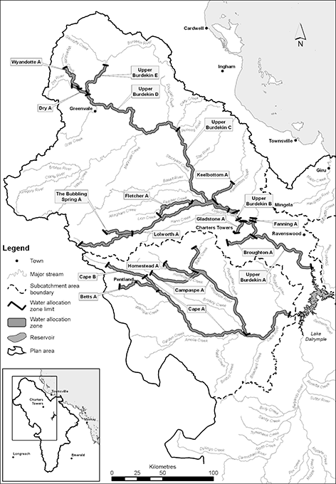
(1)Each part of the plan area shown as a subcatchment area on the map in schedule 2 is a subcatchment area for this plan.(2)Each subcatchment area is identified on the map by a letter.Subcatchment area B is identified on the map by the letter ‘B’.s 5 sub 2019 SL No. 120 s 5
6Water management areas—Act, sch 4
(1)For schedule 4 of the Act, definition water management area, paragraph (b), each part of the plan area shown as a water management area on a map in schedule 2A is a water management area.(2)Each water management area is identified on the map by its name.s 6 sub 2019 SL No. 120 s 5
s 6A ins 2017 SL No. 7 s 4
(1)Each part of the plan area shown as a water allocation zone on a map in schedule 2B is a water allocation zone for this plan.(2)Each water allocation zone is identified on the map by its name.s 7 sub 2019 SL No. 120 s 5
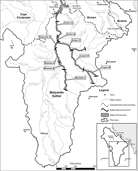
(1)Each part of the plan area shown as a water licence zone on the map in schedule 2C is a water licence zone for this plan.(2)Each water licence zone is identified on the map by its name.s 7A ins 2019 SL No. 120 s 5
For section 43(1)(e)(i) of the Act, each water allocation zone is a trading zone for water allocations to which this plan applies.s 7B ins 2019 SL No. 120 s 5
7CDeclarations about watercourses—Act, s 1006
(1)Water is declared to be water in a watercourse in the Giru Benefited Groundwater Area if the water is—(a)in an aquifer under the watercourse, or under land adjacent to the watercourse; and(b)hydraulically connected to the watercourse.(2)Water is declared to be water in a watercourse in subcatchment area E, F or G if the water is—(a)in an aquifer under the watercourse; and(b)hydraulically connected to the watercourse.s 7C ins 2019 SL No. 120 s 5
(1)The exact locations of the boundaries of the following are held in digital electronic form by the department—(a)the plan area;(b)subcatchment areas;(c)water management areas;(d)water allocation zones;(e)water licence zones;(f)the Giru Benefited Groundwater Area.(2)The information held in digital electronic form can be reduced or enlarged to show the details of the boundaries.s 8 amd 2017 SL No. 7 s 5; 2019 SL No. 120 s 6
(1)A node mentioned in this plan is a place on a watercourse in the plan area.(2)The location of each node is shown on the map in schedule 1 and described in schedule 4.(3)Each node is identified on the map by a number.
This plan applies to the following water in the plan area—(a)water in a watercourse or lake;(b)water in springs not connected to water to which the Water Plan (Great Artesian Basin and Other Regional Aquifers) 2017 applies;(c)overland flow water, other than water in springs connected to water to which the Water Plan (Great Artesian Basin and Other Regional Aquifers) 2017 applies.s 10 amd 2016 SL No. 216 s 146 sch 20; 2017 SL No. 164 s 80
pt 3 hdg sub 2017 SL No. 7 s 6
11Outcomes for water in plan area
Water is to be allocated and sustainably managed in a way that—(a)recognises the natural state of watercourses, lakes and springs has changed because of water infrastructure, flow supplementation and the taking of water; and(b)seeks to achieve a balance in the following outcomes—(i)the general outcomes mentioned in section 12;(ii)the general ecological outcomes mentioned in section 13;(iii)the specific ecological outcomes mentioned in section 14.
Each of the following is a general outcome for water in the plan area—(a)to provide for the use of all water entitlements and other authorisations in the plan area;(b)to provide for the continued use of all existing overland flow works;(c)to protect the probability of being able to take water under a water allocation;(d)to make water available to support—(i)population growth in towns and communities dependent on surface water resources in the plan area; and(ii)growth in industries dependent on surface water resources in the plan area;(e)to make water available in the Lower Burdekin and Haughton subcatchments to support—(i)water supplies for Townsville; and(ii)growth in irrigated agriculture in the Lower Burdekin, Gumlu and Bowen areas; and(iii)water supplies for other urban, industrial and mining uses; and(iv)the natural and artificial recharge of the Lower Burdekin delta groundwater system;(f)to make water available in the Upper Burdekin subcatchment to support—(i)growth in irrigated agriculture; and(ii)water supplies for the local government area of the Charters Towers Regional Council and the mining industry;(g)to make water available in the Belyando-Suttor subcatchment to support growth in irrigated agriculture;(h)to make water available in the Bowen and Broken subcatchments to support water supplies for urban, industrial, mining and other uses at Collinsville and in neighbouring areas;(i)to manage access to water to support the ongoing management of the Lower Burdekin delta groundwater system;(j)to encourage continual improvement in the efficient use of water;(k)to support water-related cultural values of Aboriginal and Torres Strait Islander communities in the plan area;(l)to ensure water is available to support natural ecosystem processes.s 12 amd 2017 SL No. 7 s 7
(1)Each of the following is a general ecological outcome for water in the plan area—(a)to maintain the natural variability of flows that support the habitats of native plants and animals and migratory birds in watercourses, floodplains, wetlands, lakes and springs;(b)to provide for the continued capability of one part of a river system to be connected to another, including by maintaining flood flows that—(i)allow for the movement of native aquatic fauna between riverine, floodplain, wetland, estuarine and marine environments; and(ii)deliver nutrients and organic matter throughout the plan area to support natural processes such as breeding, growth and migration in riverine, floodplain, wetland, estuarine and marine environments; and(iii)deliver water and sediments throughout the plan area to support river-forming processes;(c)to minimise changes to natural variability in water levels and to support natural ecological processes, including maintaining refugia associated with waterholes and lakes particularly in the Belyando-Suttor subcatchment;(d)to promote improved understanding of the matters affecting the flow-related health of ecosystems in the plan area;(e)to maintain flooding in the Lower Burdekin and Haughton subcatchments to provide freshwater inputs to wetlands on the Burdekin Haughton floodplain;(f)to provide a flow regime that—(i)maintains delivery of fresh water to the estuaries of watercourses and the Great Barrier Reef Lagoon; and(ii)maintains natural sedimentation processes to support the replenishment of beaches along the Burdekin Haughton floodplain and Cape Bowling Green; and(iii)supports productivity in the receiving waters of the Great Barrier Reef and inshore reefs.(2)In this section—refugia means the habitat required by a species during a time of stress, including, for example, drought.
14Specific ecological outcomes
Each of the following is a specific ecological outcome for water in the plan area—(a)to maintain the natural continuity of flow from immediately downstream of the Charters Towers Weir to the upstream limit of the impounded area of the Burdekin Falls Dam;(b)to maintain connectivity between Mistake Creek and its adjacent floodplain system during floods;(c)to minimise adverse impacts on the morphology of watercourses, waterholes, lakes and springs, used for taking supplemented water, in the Burdekin Haughton Water Supply Scheme;(d)to ensure there are no further impacts on natural creek flows in the Barratta Creek system;(e)to provide a flow regime that supports fish passage in the river reaches from the Clare Weir impoundment to the mouth of the Burdekin River;(f)to provide a flow regime that supports fish passage in the river reaches to the mouth of the Haughton River.
15Performance indicators for environmental flow objectives
The performance indicators for the environmental flow objectives are—(a)for assessing periods of low flow, the following—(i)50% non-zero daily flow;(ii)80% non-zero daily flow;(iii)daily flow;(iv)period of no flow; and(b)for assessing periods of medium to high flow, the following—(i)mean annual flow;(ii)median annual flow;(iii)1.5 year daily flow volume;(iv)5 year daily flow volume;(v)20 year daily flow volume;(vi)annual proportional flow deviation.
16Environmental flow objectives
The environmental flow objectives are stated in schedule 5.s 16 amd 2019 SL No. 120 s 7
17Performance indicators for water allocation security objectives
(1)This section states the performance indicators for this plan for the water allocation security objectives.(2)The performance indicators for taking water in subcatchment areas A, B, C and D are—(a)for taking supplemented water, the following—(i)the annual supplemented water sharing index;(ii)the monthly supplemented water sharing index; and(b)for taking unsupplemented water, the following—(i)the 30% unsupplemented water sharing index;(ii)the 50% unsupplemented water sharing index;(iii)the 70% unsupplemented water sharing index;(iv)the annual volume probability.(3)The performance indicator for taking water in subcatchment areas F and G is the annual volume probability.s 17 sub 2019 SL No. 120 s 8
18Water allocation security objectives
The water allocation security objectives are stated in—(a)for water allocations to take supplemented water—schedule 6, part 1; and(b)for water allocations to take unsupplemented water—schedule 6, part 2.s 18 amd 2019 SL No. 120 s 9
In this part—authority means an authority to continue to use existing overland flow works under section 80(3).s 18A ins 2019 SL No. 120 s 10
19Decisions consistent with objectives
Decisions about the allocation or management of water in the plan area, other than a decision about a water permit, must be consistent with—(a)the environmental flow objectives stated in schedule 5; and(b)the water allocation security objectives stated in schedule 6.
20Assessing impact of decisions
(1)The IQQM computer program’s simulation for the simulation period is used to assess consistency with the objectives.(2)If it is not practicable to use the IQQM computer program, another assessment method approved by the chief executive may be used.(3)The chief executive may approve an assessment method for subsection (2) only if the chief executive is satisfied the method will assess consistency with the objectives at least as accurately as the IQQM computer program.
s 21 om 2014 SL No. 142 s 39
22Restrictions on taking water from waterholes or lakes
(1)This section applies to the chief executive in making a decision about—(a)a water licence to take unsupplemented water; or(b)converting an authorisation to take unsupplemented water into a water allocation.(2)If the water licence or water allocation allows the taking of water from a waterhole or lake, the chief executive must—(a)consider the impact the taking may have on the cultural or ecological values of the waterhole or lake; and(b)impose a condition on the water licence or water allocation about maintaining the cultural or ecological values of the waterhole or lake.a condition that the water may be taken only if the water level in the waterhole or lake is above the level that is 0.5m below the level at which it naturally overflows(3)However, the chief executive need not impose a condition mentioned in subsection (2)(b) if the chief executive is satisfied—(a)the taking of water from the waterhole or lake will not adversely affect its cultural or ecological values; or(b)for a water licence or water allocation that replaces an authorisation in force immediately before the commencement of this plan—the holder of the authorisation would suffer economic hardship if the condition were imposed.s 22 amd 2017 SL No. 7 s 8
23Matters to be considered for environmental management rules
(1)In deciding the environmental management rules to be included in the water management protocol or a resource operations licence, the chief executive must consider—(a)the streamflows required to maintain the following—(i)the longitudinal connectivity of low flow habitats throughout river systems in the plan area;(ii)the wetted habitats at riffles and other streambed features;(iii)the natural seasonality of flows and zero flows;(iv)the replenishment of refuge pools that enable movement of instream biota;(v)the lateral connectivity between rivers in the plan area and their adjacent riverine environments including floodplains; and(b)the impact the taking of, or proposed taking of, or interfering with, water may have on the following—(i)water quality;(ii)the natural movement of sediment;(iii)the bed and banks of a watercourse or lake;(iv)riparian vegetation;(v)habitats for native plants and animals;(vi)the movement of fish and other aquatic species;(vii)the recreation and aesthetic values of the plan area;(viii)cultural values including, for example, cultural values of local Aboriginal or Torres Strait Islander communities.(2)Subsection (1) does not limit the matters the chief executive may consider.s 23 amd 2017 SL No. 7 s 9
24Matters to be considered for water sharing rules for unsupplemented water
(1)In deciding the water sharing rules, to be included in the water management protocol, for authorisations to take unsupplemented water in a part of the plan area, the chief executive must consider the following—(a)any existing water sharing arrangements;(b)the local availability of water that may be taken from streamflows, waterholes or bedsands;(c)the conditions for taking water decided under section 68 or 76;(d)the maximum rates decided under section 66 or 74;(e)the volumetric limits decided under section 67 or 75;(f)the impact on authorisations to take water in the plan area.(2)Subsection (1) does not limit the matters the chief executive may consider.s 24 sub 2017 SL No. 7 s 10
amd 2019 SL No. 120 s 11
s 24A ins 2014 SL No. 142 s 40
25Matters to be considered for water allocation dealing rules
(1)In deciding the water allocation dealing rules, to be included in the water management protocol, for authorisations to take water in a part of the plan area, the chief executive must consider—(a)the ongoing management of the Lower Burdekin delta groundwater system; and(b)the implications, for the availability of water under water allocations, of changes to the frequency, duration, magnitude and timing of limited water availability.(2)Subsection (1) does not limit the matters the chief executive may consider.s 25 amd 2017 SL No. 7 s 12
pt 5 div 1A hdg ins 2019 SL No. 120 s 12
This division—(a)states, for section 116 of the Act, a process for the allocation of overland flow water under a water licence to replace an authority; and(b)states a process for amending a water licence mentioned in paragraph (a).s 25A (prev s 81A) ins 2017 SL No. 7 s 36
amd 2019 SL No. 120 s 45(1)
reloc and renum 2019 SL No. 120 s 45(2)
25BNotice of proposed grant or amendment
(1)Before granting or amending a water licence, the chief executive must give the holder of the authority or the licence notice of the proposed grant or amendment.(2)The notice must—(a)state the chief executive proposes to—(i)grant a water licence to take overland flow water using the holder’s existing overland flow works; or(ii)if the holder has been granted a licence mentioned in subparagraph (i)—amend the licence; and(b)require the holder to—(i)clearly describe the overland flow works; and(ii)give the chief executive information about the pattern of water use from the works based on the requirements and purpose for which the water is, or is to be, used.(3)The notice may require the holder to give the chief executive—(a)if the notice is for a proposed grant of a water licence—a report about the taking of overland flow water under the authority to be replaced; and(b)other information the chief executive considers relevant.(4)For subsection (3)(a), the report must—(a)accurately describe—(i)the operation of the existing overland flow works; and(ii)the capacity of the works to take overland flow water; and(b)if required by the chief executive in the notice—be verified as accurate, and signed, by a registered professional engineer.(5)In this section—registered professional engineer see the Professional Engineers Act 2002, schedule 2.s 25B (prev s 81B) ins 2017 SL No. 7 s 36
reloc and renum 2019 SL No. 120 s 46
25CDecision about grant or amendment
In deciding whether to grant or amend the water licence, the chief executive—(a)must consider any report or other information given to the chief executive under section 25B; and(b)may consider other matters the chief executive considers relevant.s 25C (prev s 81C) ins 2017 SL No. 7 s 36
amd 2019 SL No. 120 s 47(1)
reloc and renum 2019 SL No. 120 s 47(2)
25DContent, conditions and effect of water licence
(1)If the water licence is granted or amended, the licence—(a)must state the purpose for which water may be taken under the licence, which must be either—(i)rural; or(ii)any; and(b)must state at least 1 of the following for the licence—(i)the maximum rate for the licence;(ii)the maximum volume of water to be stored in existing overland flow works used to take overland flow water under the licence;(iii)the volumetric limit for the licence;(iv)the mean annual volume for the licence; and(c)may state conditions under which overland flow water may be taken under the licence.(2)If a water licence is granted under this division, the authority it replaces stops having effect.s 25D (prev s 81D) ins 2017 SL No. 7 s 36
amd 2019 SL No. 120 s 48(1)
reloc and renum 2019 SL No. 120 s 48(2)
pt 5 div 1B hdg ins 2019 SL No. 120 s 12
26Accepting and deciding particular applications for water licences
(1)This section applies to the chief executive in making a decision about an application for a water licence to interfere with, or increase the interference with, surface water by impounding the flow of the water.(2)The chief executive may accept and decide the application if the purpose of the proposed interference or increase in interference is only—(a)to store water for stock purposes or domestic purposes; or(b)to provide a pumping pool to enable water to be taken under an existing authorisation; or(c)to store water for a purpose not related to the taking of water under a water entitlement.Examples of a purpose for subsection (2)(c)—
community landscaping or retaining water for flood mitigation purposes(3)The chief executive may approve the application if—(a)the chief executive is satisfied the proposed interference or increase in interference is necessary for a purpose mentioned in subsection (2); and(b)the proposed storage capacity is no greater than is necessary for the purpose of the proposed interference or increase in interference having regard to—(i)the impact the proposed interference or increase in interference may have on the following—(A)instream water levels;(B)the natural movement of sediment;(C)the bed and banks of the watercourse or lake;(D)riparian vegetation;(E)habitats for native plants and animals;(F)the movement of fish and other aquatic species;(G)the cultural and ecological values of watercourses, waterholes, lakes or springs; and(ii)for a purpose mentioned in subsection (2)(a)—existing water supplies on the property to which the application relates, including existing weirs, groundwater and dams taking overland flow water and the availability of water at the proposed site.(4)However, the chief executive must not approve an application for a purpose mentioned in subsection (2)(b) or (c) if the proposed storage capacity is greater than—(a)for an application for a purpose mentioned in subsection (2)(b)—10ML; or(b)for an application for a purpose mentioned in subsection (2)(c)—250ML.(5)This section does not apply to an application about unallocated water.(6)In this section—pumping pool means a pool of water near a pump in a watercourse, lake or spring that ensures the water level of the watercourse, lake or spring is appropriate to enable the pump to function properly.s 26 amd 2019 SL No. 120 s 13
26AParticular applications for water licences that must not be accepted
(1)This section does not apply to an application to which section 26 applies.(2)An application for a water licence must not be accepted under section 107 of the Act if the application is for a water licence to—(a)take surface water and use the water on the land; or(b)interfere with the flow of surface water on, under or adjoining the land.s 26A ins 2017 SL No. 7 s 13
amd 2019 SL No. 120 s 14
pt 5 div 1C hdg ins 2019 SL No. 120 s 15
26BAccepting and deciding applications for dealings with water licences to take or interfere with surface water
(1)This section applies to the chief executive in making a decision about an application for 1 or more dealings with a water licence to take or interfere with surface water, other than an application to which section 26 applies.(2)The chief executive may accept and decide the application if granting the application would not do any of the following—(a)increase the volumetric limit for surface water taken under the licence;(b)increase the interference with surface water under the licence;(c)for an application relating to an unzoned water licence—(i)change a location from which surface water may be taken under the licence; or(ii)change a condition of the licence, other than by removing a water storage condition.(3)In this section—unzoned water licence means a water licence under which surface water may be taken from land that is not in or adjacent to a water licence zone.s 26B ins 2017 SL No. 7 s 13
amd 2019 SL No. 120 s 16
27Deciding applications to increase maximum rate for water licences
(1)This section applies to the chief executive in making a decision about an application to increase the maximum rate for a water licence to take surface water.(2)The chief executive may grant the application if—(a)the existing works for taking surface water under the licence have the capacity to take water at the maximum rate applied for; and(b)if the existing works include a pump—the maximum rate applied for does not exceed—(i)for a pump of a size mentioned in schedule 8, column 1—the corresponding rate stated in schedule 8, column 2 for the pump size; or(ii)for a pump of another size—the rate decided by the chief executive having regard to the corresponding rates stated for similar pump sizes in schedule 8, column 2.s 27 prev s 27 om 2014 SL No. 142 s 41
pres s 27 ins 2017 SL No. 7 s 13
amd 2019 SL No. 120 s 17
27ADeciding applications to change location for taking water under, or condition of, a water licence
(1)This section applies to an application to change the location from which water may be taken under a water licence—(a)from a location in a water licence zone; and(b)to another location in the same, or another, water licence zone.(2)Also, this section applies to an application to change the conditions of a water licence, including an application to which section 27B applies.(3)For section 43(2)(i) of the Act, the chief executive may grant the application if the chief executive is satisfied the dealing is permitted under the water management protocol.(4)This section does not limit section 27B.s 27A ins 2019 SL No. 120 s 18
27BDeciding application to amend water licence by removing water storage condition
(1)This section applies in relation to an application to amend a water licence (the existing licence) by removing a water storage condition of the licence.(2)If the chief executive grants the application, the chief executive must grant to the applicant a water licence (the separate licence) to take overland flow water.(3)The separate licence—(a)must authorise the taking of overland flow water only from the location at which water was taken or interfered with under the existing licence; and(b)must state the purpose for which water may be taken under the separate licence, which must be either—(i)rural; or(ii)any; and(c)must state at least 1 of the following for the separate licence—(i)the maximum rate;(ii)the maximum volume of water to be stored in existing overland flow works used to take overland flow water under the licence;(iii)the volumetric limit;(iv)the mean annual volume; and(d)may state conditions under which overland flow water may be taken under the separate licence.s 27B (prev s 80A) ins 2017 SL No. 7 s 35
reloc and renum 2019 SL No. 120 s 44
27CApplications for dealings with water licences inconsistent with this plan—Act, s 129
(1)This section applies for an application for a dealing with a water licence, other than an application to which section 27A applies.(2)Granting the application would be inconsistent with this plan if granting the application would—(a)increase the amount of water that may be taken under the licence; or(b)increase the rate at which water may be taken under the licence; or(c)change a location of taking or interfering with water under the licence; or(d)increase or change the interference with water under the licence.See section 129 of the Act for the actions the chief executive must take if the granting of an application for a dealing with a water licence is inconsistent with a water plan.s 27C ins 2019 SL No. 120 s 19
pt 5 div 1D hdg ins 2019 SL No. 120 s 20
28Deciding applications for water licences to take water for stock purposes or domestic purposes
(1)This section applies to the chief executive in making a decision about an application for a water licence to take surface water if—(a)the proposed taking is for—(i)stock purposes only; or(ii)domestic purposes only; or(iii)stock purposes and domestic purposes only; and(b)the proposed location for the taking is not in a water allocation zone.(2)The chief executive may grant the application if the chief executive is satisfied—(a)the applicant does not hold a water entitlement allowing the taking of water from the proposed location; and(b)there is no alternative water supply to the proposed location; and(c)there is no unallocated water at the proposed location for which the applicant may apply for a water entitlement; and(d)there is a registered plan of survey for the land containing the proposed location; and(e)the plan of survey was registered before the final draft of the pre-amendment resource operations plan was approved under section 103(5) of the pre-amendment Act.(3)Subsection (2) does not limit the matters the chief executive may consider.(4)In this section—pre-amendment Act means the Act as in force immediately before 6 December 2016.pre-amendment resource operations plan means the resource operations plan to implement the pre-amendment water resource plan as in force immediately before 6 December 2016.pre-amendment water resource plan means this plan as in force immediately before 6 December 2016.registered plan of survey means a plan of survey registered under the Land Title Act 1994.s 28 prev s 28 om 2014 SL No. 142 s 41
pres s 28 ins 2017 SL No. 7 s 13
amd 2019 SL No. 120 s 21
pt 5 div 1E hdg ins 2019 SL No. 120 s 22
28AGrant of water licence for taking surface water—Act, s 116
(1)This section applies if a water entitlement notice for this plan provides for the grant of a water licence to take or interfere with surface water.(2)For section 116(1) of the Act, the chief executive must grant the water licence.See section 116(2) of the Act for when the chief executive may grant the water licence without the need for an application to be made under section 107 of the Act.s 28A ins 2019 SL No. 120 s 22
pt 5 div 2 hdg sub 2017 SL No. 7 s 14
pt 5 div 2 sdiv 1 hdg prev sdiv hdg om 2014 SL No. 142 s 41
pres sdiv hdg ins 2017 SL No. 7 s 14
29Unallocated water held as general, strategic or SunWater reserve
Unallocated water is held as a general reserve, strategic reserve or SunWater reserve and dealt with under this division.s 29 amd 2014 SL No. 142 s 42
sub 2017 SL No. 7 s 14
30Volumes of unallocated water held
For section 43(1)(c) of the Act—(a)the volume of unallocated water held as a general reserve is 200,000ML; and(b)the volume of unallocated water held as a strategic reserve is 335,000ML; and(c)the volume of unallocated water held as a SunWater reserve is 8,744ML.For the volume of unallocated water held as a general reserve, strategic reserve and SunWater reserve for particular subcatchment areas, see the water management protocol.s 30 amd 2014 SL No. 142 s 43
31Volume of unallocated water held as general reserve or strategic reserve for subcatchment areas
(1)The volume of unallocated water held as a general reserve or a strategic reserve in a subcatchment area is the volume stated for the reserve in the water management protocol for the subcatchment area.(2)This section does not limit section 30(1) or (2).s 31 sub 2017 SL No. 7 s 14
32Release of unallocated water held as strategic reserve
Unallocated water held as a strategic reserve may be released for the following purposes—(a)35,000ML for State purposes;(b)150,000ML for a future raising of the Burdekin Falls Dam by up to 2m;(c)150,000ML for water infrastructure for the Bowen and Broken subcatchment areas for industrial purposes.s 32 sub 2017 SL No. 7 s 14
pt 5 div 2 sdiv 2 hdg sub 2017 SL No. 7 s 14
(1)Unallocated water may be released from the general reserve, strategic reserve or SunWater reserve under section 33A.(2)However, the volume of unallocated water released from the strategic reserve for a purpose mentioned in section 32 can not be more than the volume that may be released for the purpose under that section.s 33 sub 2017 SL No. 7 s 14
33AProcesses for release of unallocated water
(1)Subsection (2) applies to the release of unallocated water held as—(a)a general reserve; or(b)a strategic reserve for a State purpose.(2)The process for releasing the unallocated water is the process stated in the Water Regulation 2016, part 2, division 2, subdivision 2.(3)Subsection (4) applies to the release of unallocated water held as—(a)a strategic reserve for a purpose other than a State purpose; or(b)a SunWater reserve.(4)The process for releasing the unallocated water is the process stated in the water management protocol.s 33A ins 2017 SL No. 7 s 14
33BUnallocated water released for coordinated project or project of regional significance
(1)This section applies to a volume of unallocated water released from the strategic reserve for either of the following State purposes—(a)a coordinated project;(b)a project of regional significance.(2)The volume of unallocated water is released only for the life of the project and, on conclusion of the project, the volume of water returns to the strategic reserve as unallocated water to be released for State purposes.s 33B ins 2017 SL No. 7 s 14
pt 5 div 2 sdiv 3 hdg om 2017 SL No. 7 s 14
pt 5 div 3 hdg prev div 3 hdg om 2017 SL No. 7 s 15
pres div 3 hdg ins 2019 SL No. 120 s 24
pt 5 div 3 sdiv 1 hdg om 2017 SL No. 7 s 15
pt 5 div 3 sdiv 2 hdg om 2017 SL No. 7 s 15
pt 5 div 3 sdiv 3 hdg om 2017 SL No. 7 s 15
pt 5 div 3 sdiv 4 hdg om 2017 SL No. 7 s 15
pt 5 div 3 sdiv 5 hdg om 2017 SL No. 7 s 15
34Limitation on authorisation to take water for prescribed activity—Act, s 101
For section 101(1) of the Act, a person may take not more than 5ML of water in subcatchment area E, F or G for a prescribed activity under the Water Regulation 2016.s 34 prev s 34 om 2017 SL No. 7 s 15
pres s 34 ins 2019 SL No. 120 s 24
35Limitation on authorisation to take water for stock purposes or domestic purposes—Act, s 103
(1)For section 103(a) of the Act—(a)water in a watercourse in the Burdekin Haughton Water Supply Scheme or the Bowen Broken Water Supply Scheme may only be taken using existing stock or domestic works; and(b)other water in the plan area may be taken in any way.(2)In this section—existing stock or domestic works means works used, before the commencement, to take water from a watercourse for stock purposes or domestic purposes.s 35 prev s 35 om 2017 SL No. 7 s 15
pres s 35 ins 2019 SL No. 120 s 24
s 36 om 2017 SL No. 7 s 15
s 37 om 2017 SL No. 7 s 15
s 38 om 2017 SL No. 7 s 15
s 39 om 2017 SL No. 7 s 15
s 40 om 2017 SL No. 7 s 15
s 41 om 2017 SL No. 7 s 15
s 42 om 2017 SL No. 7 s 15
s 43 om 2017 SL No. 7 s 15
s 44 om 2017 SL No. 7 s 15
s 45 om 2017 SL No. 7 s 15
s 46 om 2017 SL No. 7 s 15
pt 5 div 4 hdg om 2014 SL No. 142 s 44
s 47 om 2014 SL No. 142 s 44
s 48 om 2014 SL No. 142 s 44
s 49 om 2014 SL No. 142 s 44
s 50 om 2014 SL No. 142 s 44
pt 5 div 5 hdg om 2014 SL No. 142 s 44
s 51 om 2014 SL No. 142 s 44
s 52 om 2014 SL No. 142 s 44
s 53 om 2014 SL No. 142 s 44
pt 5 div 6 hdg sub 2019 SL No. 120 s 25
pt 5 div 6 sdiv 1 hdg om 2017 SL No. 7 s 16
pt 5 div 6 sdiv 2 hdg om 2014 SL No. 142 s 45
pt 5 div 6 sdiv 3 hdg om 2017 SL No. 7 s 19
This division states, for section 43(2)(g) of the Act, arrangements and process for converting, under a water entitlement notice for this plan, particular water licences to water allocations to take unsupplemented water.s 54 sub 2017 SL No. 7 s 17; 2019 SL No. 120 s 26
55Existing water licences may be converted to water allocations
(1)A water entitlement notice may, under section 70(1)(a) of the Act, implement this plan by providing for the conversion of a water licence to take unsupplemented water from the Upper Burdekin water management area or the Cape Campaspe water management area to a water allocation (a new water allocation) to take unsupplemented water.(2)In a provision about a new water allocation, a reference to a water licence is a reference to the water licence that is converted to the new water allocation.s 55 sub 2019 SL No. 120 s 26
56Matters to be stated on new water allocation
A new water allocation must state the following—(a)the location from which water may be taken under the allocation;(b)the water allocation zone in which the location is situated;(c)the maximum rate for the allocation;(d)the volumetric limit for the allocation;(e)the purpose for which water may be taken under the allocation;(f)any conditions of the water allocation.s 56 amd 2017 SL No. 7 s 18
sub 2019 SL No. 120 s 26
57Location from which water may be taken under new water allocation
The location from which water may be taken under a new water allocation must—(a)include the place at which water may be taken under the water licence; and(b)be in a water allocation zone.s 57 prev s 57 om 2014 SL No. 142 s 45
pres s 57 ins 2019 SL No. 120 s 26
58Purpose for which water may be taken under new water allocation
The purpose for which water may be taken under a new water allocation must be ‘any’.s 58 prev s 58 om 2014 SL No. 142 s 45
pres s 58 ins 2019 SL No. 120 s 26
s 59 om 2014 SL No. 142 s 45
s 60 om 2014 SL No. 142 s 45
s 61 om 2014 SL No. 142 s 45
s 62 om 2017 SL No. 7 s 20
63Elements of a new water allocation
A new water allocation must state each of the following for the allocation—(a)the per-second rate;(b)the maximum rate;(c)the volumetric limit;(d)the flow conditions.s 63 sub 2014 SL No. 142 s 46; 2017 SL No. 7 s 21
amd 2019 SL No. 120 s 27
64Nominal volumes for new water allocations
In deciding the nominal volume for a new water allocation, the chief executive must have regard to the following—(a)the local availability of water;(b)the conditions under which water may be taken under the water licence;(c)if the water licence states any volumetric limits—the volumetric limits;(d)the simulated mean annual diversion for the water licence.s 64 amd 2017 SL No. 7 s 22; 2019 SL No. 120 s 28
s 65 sub 2017 SL No. 7 s 23
(1)The maximum rate for a new water allocation is—(a)if the water licence states the volume of water that may be taken in a day—the stated volume; or(b)if the water licence states a per-second rate—the maximum rate worked out by multiplying the per-second rate by 86,400; orThere are 86,400 seconds in a day.(c)if the water licence does not state a volume or a per-second rate, but the works for taking water under the water licence include a pump—(i)for a pump of a size mentioned in schedule 8, column 1—the maximum rate stated in schedule 8, column 2 for the pump size; or(ii)for a pump of another size—the maximum rate decided by the chief executive having regard to the maximum rates stated for similar pump sizes in schedule 8, column 2; or(d)otherwise—the maximum rate decided by the chief executive, having regard to an estimate or measurement of the maximum rate at which water can be taken under the water licence.(2)However, for subsection (1)(b), if the water licence holder satisfies the chief executive that the water taking capacity of the pump is different from the maximum rate determined under that subsection, the maximum rate is the volume decided by the chief executive having regard to the following—(a)the conditions under which the water may be taken under the water licence;(b)the water taking capacity of any works for taking water under the water licence;(c)the irrigation or water distribution system related to the works during a period, of not more than 10 years, immediately before the draft water entitlement notice that provided for the conversion of the water licence was published;(d)the efficiency of the water use mentioned in paragraph (c).(3)The chief executive must ensure the maximum rate for a new water allocation is not more than the volume that could be taken in a day at the per-second rate for the new water allocation.s 66 sub 2017 SL No. 7 s 23
amd 2019 SL No. 120 s 30
The volumetric limit for a new water allocation is—(a)for a water licence that states the volume of water that may be taken in a period of 12 months—the stated volume; and(b)for another water licence—the volume decided by the chief executive having regard to the following—(i)the conditions under which water may be taken under the water licence;(ii)the water taking capacity of any works for taking water under the water licence;(iii)the volume required for the allocation’s intended purpose;(iv)the annual volumes of water estimated by the chief executive to have been taken under the water licence during the period, of not more than 10 years, immediately before the commencement of this plan;(v)the efficiency of the use of the water mentioned in subparagraph (iv).s 67 amd 2017 SL No. 7 s 24; 2019 SL No. 120 s 31
(1)The chief executive may impose on a new water allocation any condition the chief executive is satisfied is necessary to ensure the purpose and outcomes of this plan are achieved.(2)In deciding the flow conditions under which water may be taken under the allocation, the chief executive must have regard to the conditions stated on the water licence.s 68 amd 2017 SL No. 7 s 25; 2019 SL No. 120 s 32
The water allocation group for a new water allocation is stated in schedule 8A, column 2 opposite the subcatchment area from which water may be taken under the allocation.s 69 amd 2017 SL No. 7 s 26
sub 2019 SL No. 120 s 33
This division applies only to water licences to take or interfere with unsupplemented water that is surface water.s 70 amd 2019 SL No. 120 s 34
71Water licences to take unsupplemented water
A water licence to take unsupplemented water must state the following—(a)the purpose for which water may be taken under the licence, which must be 1 of the following—(i)stock and domestic;(ii)rural;(iii)any;(b)the maximum rate for the licence;(c)the volumetric limit for the licence.s 71 sub 2014 SL No. 142 s 47
72Purpose to be stated on water licence to take unsupplemented water
The purpose stated on a water licence to take unsupplemented water, replacing an existing licence, must be—(a)if the purpose stated on the existing licence is stock purposes or domestic purposes—‘stock and domestic’; or(b)if the purpose stated on the existing licence is irrigation, stock intensive, agriculture or a similar purpose—‘rural’; or(c)otherwise—‘any’.s 72 amd 2019 SL No. 120 s 36
s 73 sub 2014 SL No. 142 s 48; 2017 SL No. 7 s 28
74Maximum rates for water licences to take unsupplemented water
(1)The maximum rate for a water licence to take unsupplemented water is—(a)if the licence states the volume of water that may be taken in a day—the stated volume; or(b)if the licence does not state a volume but the works for taking water under the licence include a pump—(i)for a pump of a size mentioned in schedule 8, column 1—the maximum rate stated in schedule 8, column 2 for the pump size; or(ii)for a pump of another size—the maximum rate decided by the chief executive having regard to the maximum rates stated for similar pump sizes in schedule 8, column 2; or(c)otherwise—the maximum rate decided by the chief executive having regard to—(i)the type of licence; and(ii)an estimate or measurement of the maximum rate at which water can be taken under the licence.(2)However, for subsection (1)(b), if the licence holder satisfies the chief executive that the water taking capacity of the pump is different from the maximum rate determined under that subsection, the maximum rate is the volume decided by the chief executive having regard to the following—(a)the conditions under which the water may be taken under the licence;(b)the water taking capacity of any works for taking water under the licence;(c)the irrigation or water distribution system related to the works during a period, of not more than 10 years, immediately before the commencement of this plan;(d)the efficiency of the water use mentioned in paragraph (c).(3)Also, if the water licence states a per-second rate, the chief executive must ensure the maximum rate for the licence is not more than the total volume that could be taken in a day at the per-second rate.s 74 sub 2014 SL No. 142 s 48; 2017 SL No. 7 s 28
amd 2019 SL No. 120 s 38
75Volumetric limits for water licences to take unsupplemented water
The volumetric limit for a water licence to take unsupplemented water is—(a)for a licence that states the volume of water that may be taken in a period of 12 months—the stated volume; and(b)for a licence that states the area that may be irrigated—the volume decided by the chief executive having regard to the volume of water required for the licence’s intended purpose, but not more than the volume, expressed in megalitres, calculated by multiplying the area, in hectares, by—(i)for subcatchment areas A and B—8; and(ii)for subcatchment area C—9; and(iii)for subcatchment area D—6; and(iv)for other subcatchment areas—12; and(c)for another licence—the volume decided by the chief executive having regard to the following—(i)the conditions under which water may be taken under the licence;(ii)the water taking capacity of any works for taking water under the licence;(iii)the volume required for the licence’s intended purpose;(iv)the annual volumes of water estimated by the chief executive to have been taken under the licence during the period, of not more than 10 years, immediately before the commencement of this plan;(v)the efficiency of the use of the water mentioned in subparagraph (iv).s 75 amd 2017 SL No. 7 s 29
76Conditions for taking unsupplemented water
(1)The chief executive may impose on a water licence to take unsupplemented water any condition the chief executive is satisfied is necessary to ensure the purpose and outcomes of this plan are achieved.(2)In deciding the flow conditions under which water may be taken under the licence, the chief executive must have regard to the conditions stated on the licence.
77Storing unsupplemented water taken under a water licence
(1)Without limiting section 76(1), the chief executive may impose, on a water licence to take unsupplemented water, a condition that states the works that may be used to store the water taken under the licence.(2)In deciding whether to impose the condition mentioned in subsection (1), the chief executive must have regard to the capacity of any existing overland flow works being used to store the water.
s 78 om 2017 SL No. 7 s 30
pt 5 div 8 hdg amd 2019 SL No. 120 s 39
pt 5 div 8 sdiv 1 hdg ins 2017 SL No. 7 s 32
pt 5 div 8 sdiv 2 hdg ins 2017 SL No. 7 s 34
79Limitation on taking overland flow water—Act, s 101
(1)This section prescribes limits, for section 101(1)(b) of the Act, on an authorisation for a person to take overland flow water under that section.See section 101(3) of the Act for the circumstances in which a person may take overland flow water that is contaminated agricultural run-off.(2)A person may not take overland flow water other than—(a)for stock purposes or domestic purposes; or(b)for another purpose if the works for taking the overland flow water have a capacity of not more than 250ML; or(c)under a water licence; or(d)overland flow water of not more than the amount necessary to satisfy the requirements of—(i)an environmental authority issued under the Environmental Protection Act 1994; or(ii)a development permit for carrying out an environmentally relevant activity, other than a mining or petroleum activity, under the Environmental Protection Act 1994; or(e)under an authority under section 80.(3)In this section—contaminated agricultural runoff water has the meaning given by the ‘Code for Assessable Development for Operational Works for Taking Overland Flow Water’.A copy of the code is available on the department’s website.s 79 amd 2013 Act No. 23 s 352 sch 1 pt 2; 2017 SL No. 7 s 31; 2019 SL No. 120 s 41
80Taking water using particular existing overland flow works authorised
(1)This section applies to the owner of land on which existing overland flow works are situated, other than works for taking only the overland flow water that may be taken under section 79(2)(a) to (d).(2)The owner may continue to use the existing overland flow works to take overland flow water for 1 year after the amendment day.(3)Also, if the owner gives the chief executive notice of the existing overland flow works, in the approved form, and any further information reasonably required by the chief executive about the works, the owner may continue to use the works to take overland flow water after the notice and information are given.(4)In this section—amendment day means the day the Water Amendment Plan (Burdekin Basin) 2019 commences.s 80 amd 2017 SL No. 7 s 33; 2019 SL No. 120 s 42
In this subdivision—authority means an authority to continue to use existing overland flow works under section 80(3).s 81 ins 2017 SL No. 7 s 36
pt 5 div 9 hdg amd 2009 SL No. 280 s 156
s 82 amd 2009 SL No. 280 s 157; 2011 Act No. 40 s 107 sch
s 82A ins 2010 SL No. 261 s 3
pt 6 hdg sub 2014 SL No. 142 s 49
83Monitoring and reporting requirements
(1)To help the Minister assess the effectiveness of the management strategies for achieving the outcomes mentioned in part 3, the water management protocol must state the monitoring requirements for water and natural ecosystems for this plan.(2)Subsection (1) does not limit the monitoring requirements the chief executive may impose for this plan.s 83 sub 2014 SL No. 142 s 49
amd 2017 SL No. 7 s 37
s 84 sub 2014 SL No. 142 s 49
s 85 om 2014 SL No. 142 s 49
pt 7 hdg sub 2017 SL No. 7 s 38
amd 2019 SL No. 120 s 49
86Water management protocol—Act, s 43
(1)For section 43(2)(l) of the Act, a water management protocol must be prepared for the plan area.(2)The water management protocol must address the following matters for the plan area—(a)the volumes of unallocated water reserved for stated purposes or stated locations;(b)the process for releasing unallocated water held as SunWater reserve;(c)the water allocation dealing rules that apply to the plan area;(d)for sections 126(1)(b) and 130(1)(c) of the Act, the dealings to amend a water licence to change the location from which water may be taken under the licence that are permitted;(e)the criteria and process for deciding an application for a dealing with a water licence mentioned in section 27A.s 86 prev s 86 om 2014 SL No. 142 s 49
pres s 86 ins 2019 SL No. 120 s 50
87Amendments of a type not requiring public consultation—Act, s 51
For section 51(2)(a) of the Act, the following types of amendment to this plan do not require public consultation on a draft of the plan—(a)an amendment or addition of—(i)an environmental flow objective, if the amendment or addition achieves an equivalent or improved ecological outcome without adversely affecting the water allocation security objectives or the outcomes under part 3; or(ii)a node; or(iii)a priority group; or(iv)a water allocation group; or(v)a water allocation security objective, if the amendment or addition does not adversely affect existing water allocations, environmental flow objectives or the outcomes under part 3; or(vi)a water management area;(b)an amendment of the capacity mentioned in section 79(2)(b);(c)an amendment to subdivide a subcatchment area.s 87 amd 2014 SL No. 142 s 50
sub 2017 SL No. 7 s 38
s 88 amd 2009 SL No. 280 s 158; 2014 SL No. 142 s 51; 2016 SL No. 216 s 146 sch 20
s 89 om 2017 SL No. 7 s 38
sections 4 and 9
sch 1 sub 2019 SL No. 120 s 51
sch 2 sub 2019 SL No. 120 s 51
sch 2A ins 2017 SL No. 7 s 39
sub 2019 SL No. 120 s 51
sch 2B ins 2019 SL No. 120 s 52
sch 2C ins 2019 SL No. 120 s 52
schedule 10, definition Giru Benefited Groundwater Area
sch 3 amd 2019 SL No. 120 s 53
Column 1 | Column 2 |
Node | Location |
1 | Burdekin River at the river’s downstream limit |
1A | Burdekin River anabranch at the anabranch’s downstream limit |
2 | Haughton River at the river’s downstream limit |
3 | Haughton River at the supplementation point (AMTD 42km) |
4 | Burdekin River at its confluence with the anabranch (AMTD 10km) |
5 | Burdekin River at Warren’s Gully (AMTD 34.7km) |
6 | Burdekin River immediately downstream of Clare Weir (AMTD 50.3km) |
7 | Burdekin River immediately downstream of Burdekin Falls Dam (AMTD 158.8km) |
8 | Burdekin River immediately upstream of its confluence with the Suttor River (AMTD 174.5km) |
9 | Burdekin River immediately downstream of Charters Towers Weir (AMTD 317km) |
10 | Cape River at its confluence with the Suttor River (AMTD 0.0km) |
11 | Suttor River at its confluence with the Burdekin River (AMTD 0.0km) |
12 | Bowen River at the upstream limit of the impounded area of the Blue Valley Weir (AMTD 5.5km) |
13 | Bowen River immediately downstream of Bowen River Weir (AMTD 94.4km) |
14 | Broken River immediately downstream of Eungella Dam (AMTD 71.2km) |
sch 4 amd 2010 SL No. 261 s 4; 2016 SL No. 216 s 146 sch 20
Column 1 Column 2 Column 3 Column 4 Node Percentage Percentage Percentage 1 24 65 5 2 15 26 66 8 44 69 15 10 25 41 49 11 32 52 35 12 32 62 151At each node mentioned in table 1, column 1—
(a)the percentage of the total number of days in the simulation period that the 50% non-zero daily flow is equalled or exceeded be at least the percentage stated, for the node, in table 1, column 2; and
(b)the percentage of the total number of days in the simulation period that the 80% non-zero daily flow is equalled or exceeded be at least the percentage stated, for the node, in table 1, column 3; and
(c)the percentage of the total number of days in the simulation period that the daily flow is zero be not more than the percentage stated, for the node, in table 1, column 4.
Table 1
2At each node mentioned in table 2, column 1, the percentage of the total number of days in a water flow season in the simulation period that the 80% non-zero daily flow is equalled or exceeded be at least the percentage stated for the water flow season, for the node, in table 2, column 2.Table 2
Column 1
Column 2
Node
Water flow season
January–
March water flow season percentage
April–
June water flow season percentage
July–
September water flow season percentage
October–
December water flow season percentage
1
92
84
45
44
2
64
29
4
9
12
85
81
46
35
3At each node mentioned in table 3, column 1—(a)the number of periods of no flow of more than 1 month but not more than 6 months in the simulation period be not more than the number stated for the node in table 3, column 2; and(b)the number of periods of no flow of more than 6 months in the simulation period be not more than the number stated for the node in table 3, column 3.Table 3
Column 1
Column 2
Column 3
Node
Periods of no flow of more than 1 month but not more than 6 months
Periods of no flow of more than 6 months
1
11
0
2
144
43
8
57
1
10
165
3
11
118
1
12
54
2
Column 1 Column 2 Column 3 Column 4 Column 5 Column 6 Node Mean annual flow percentage Median annual flow percentage 1.5 year daily flow volume percentage 5 year daily flow volume percentage 20 year daily flow volume percentage 1 75 59 50 79 86 2 92 88 95 — — 8 97 96 99 — — 10 98 97 98 99 99 11 92 88 94 96 98 12 82 80 92 86 861At each node mentioned in table 4, column 1—
(a)the mean annual flow in the simulation period, expressed as a percentage of the mean annual flow for the pre-development flow pattern, be at least the percentage stated for the node in table 4, column 2; and
(b)the median annual flow in the simulation period, expressed as a percentage of the median annual flow for the pre-development flow pattern, be at least the percentage stated for the node in table 4, column 3; and
(c)the 1.5 year daily flow volume in the simulation period, expressed as a percentage of the 1.5 year daily flow volume for the pre-development flow pattern, be at least the percentage stated for the node in table 4, column 4; and
(d)the 5 year daily flow volume in the simulation period, expressed as a percentage of the 5 year daily flow volume for the pre-development flow pattern, be at least the percentage stated for the node in table 4, column 5; and
(e)the 20 year daily flow volume in the simulation period, expressed as a percentage of the 20 year daily flow volume for the pre-development flow pattern, be at least the percentage stated for the node in table 4, column 6.
Table 4
2At each node mentioned in table 5, column 1, the annual proportional flow deviation be not more than the annual proportional flow deviation stated for the node in table 5, column 2.
Table 5
Column 1 | Column 2 |
Node | Annual proportional flow deviation |
1 | 2.9 |
2 | 1.8 |
10 | 0.2 |
11 | 1.0 |
12 | 1.2 |
sch 5 amd 2014 SL No. 142 s 52
1For water allocations in the high priority group in the Burdekin Haughton Water Supply Scheme, the annual supplemented water sharing index be 100%.
2For water allocations in the medium priority group in the Burdekin Haughton Water Supply Scheme—
(a)the annual supplemented water sharing index be at least 90%; and
(b)the monthly supplemented water sharing index be at least 95%; and
3For water allocations in the high A1 priority group in the Bowen Broken Water Supply Scheme—
(a)the annual supplemented water sharing index be at least 95%; and
(b)the extent to which it is less than 99% be minimised; and
(c)the monthly supplemented water sharing index be at least 98%.
4For water allocations in the high A2 priority group in the Bowen Broken Water Supply Scheme—
(a)the annual supplemented water sharing index be at least 90%; and
(b)the extent to which it is less than 95% be minimised; and
(c)the monthly supplemented water sharing index be at least 98%; and
(d)the extent to which it is less than 99% be minimised.
5For water allocations in the medium priority group in the Bowen Broken Water Supply Scheme—
(a)the annual supplemented water sharing index be at least 65%; and
(b)the extent to which it is less than 75% be minimised; and
(c)the monthly supplemented water sharing index be at least 85%; and
(d)the extent to which it is less than 90% be minimised.
Column 1 Column 2 Column 3 Column 4 Water allocation group 30% unsupplemented water sharing index percentage 50% unsupplemented water sharing index percentage 70% unsupplemented water sharing index percentage A1 (Lower Burdekin) 107 107 107 B1 (Haughton) 107 107 107 C1 (Bowen) 110 110 1101For water allocations in a water allocation group mentioned in table 1, column 1—
(a)the 30% unsupplemented water sharing index be at least the percentage stated for the group in table 1, column 2; and
(b)the 50% unsupplemented water sharing index be at least the percentage stated for the group in table 1, column 3; and
(c)the 70% unsupplemented water sharing index be at least the percentage stated for the group in table 1, column 4.
Table 1
2For water allocations in a water allocation group mentioned in table 2, column 1, the annual volume probability be at least the percentage stated for the group in table 2, column 2.Table 2
Column 1
Column 2
Water allocation group
Annual volume probability (%)
A1
85
B1
85
C1
75
F1
52
F2
39
G1
37
G2
45
G3
40
G4
71
sch 6 amd 2019 SL No. 120 s 54
sch 7 om 2014 SL No. 142 s 53
sections 27(2), 66(1)(b) and 74(1)
Column 1 | Column 2 |
Pump size (mm) | Maximum rate (megalitres/day) |
32 | 0.6 |
40 | 1 |
50 | 1.5 |
65 | 3.5 |
80 | 3.9 |
100 | 6.9 |
125 | 7.8 |
150 | 12.1 |
200 | 15.6 |
250 | 21.6 |
300 | 25.9 |
350 | 30.2 |
375 to 400 | 37.2 |
500 | 47.5 |
600 to 610 | 86.4 |
650 to 660 | 120 |
700 to 720 | 150 |
750 to 770 | 180 |
780 to 810 | 200 |
sch 8 amd 2017 SL No. 7 s 40
sub 2019 SL No. 120 s 55
Column 1 | Column 2 |
Subcatchment area from which water may be taken | Water allocation group |
Subcatchment area A | B1 |
Subcatchment area B | A1 |
Subcatchment area C | C1 |
Subcatchment area D | C1 |
Subcatchment area F | F1 |
Subcatchment area G | G1 |
sch 8A ins 2019 SL No. 120 s 56
sch 10, definition annual proportional flow deviation
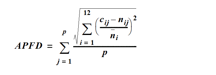
p means the number of years.
cij means the modelled flow for month i in year j.
nij means the modelled natural flow for month i in year j.
ni means the modelled natural flow for month i across p years.
1.5 year daily flow volume, for a node, means the daily flow, at the node, that has a 67% probability of being reached at least once a year.
5 year daily flow volume, for a node, means the daily flow, at the node, that has a 20% probability of being reached at least once a year.
20 year daily flow volume, for a node, means the daily flow, at the node, that has a 5% probability of being reached at least once a year.
30% unsupplemented water sharing index, for a group of water allocations, means the total volume of water simulated to have been taken annually under the allocations in at least 30% of years in the simulation period, if the allocations were in existence for the whole of the simulation period, expressed as a percentage of the simulated mean annual diversion for the allocations.
50% non-zero daily flow, for a node, means the daily flow, at the node, that is equalled or exceeded on 50% of the days on which there is a flow in the simulation period for the pre-development flow pattern.
50% unsupplemented water sharing index, for a group of water allocations, means the total volume of water simulated to have been taken annually under the allocations in at least 50% of years in the simulation period, if the allocations were in existence for the whole of the simulation period, expressed as a percentage of the simulated mean annual diversion for the allocations.
70% unsupplemented water sharing index, for a group of water allocations, means the total volume of water simulated to have been taken annually under the allocations in at least 70% of years in the simulation period, if the allocations were in existence for the whole of the simulation period, expressed as a percentage of the simulated mean annual diversion for the allocations.
80% non-zero daily flow, for a node, means the daily flow, at the node, that is equalled or exceeded on 80% of the days on which there is a flow in the simulation period for the pre-development flow pattern.
adopted middle thread distance means the distance in kilometres, measured along the middle of a watercourse, that a specific point in the watercourse is, at the commencement of this plan, from—
(a)the watercourse’s mouth; or
(b)if the watercourse is not a main watercourse—the watercourse’s confluence with its main watercourse.
AMTD means adopted middle thread distance.
annual flow volume, for a node, means the total volume of flow, at the node, in a period of 12 months starting on 1 July.
annual proportional flow deviation, for a node, means the statistical measure of changes to flow season and volume in the simulation period, at the node, calculated using the formula in schedule 9.
annual supplemented water sharing index, for water allocations to take supplemented water in a particular priority group, means the percentage of years in the simulation period in which the allocations are fully supplied.
annual variability, for a flow at a point in a watercourse, means the amount of change in the flow that happens between years.
annual volume probability, for a group of water allocations, means the percentage of years in the simulation period in which the volume of water that may be taken by the group is at least the total of the nominal volumes for the allocations in the group.
annual volumetric limit ...
sch 10 def annual volumetric limit om 2017 SL No. 7 s 41(1)
authorisation means a licence, permit, interim water allocation or other authority to take water given under the Act or the repealed Act, other than a permit for stock purposes or domestic purposes.
sch 10 def authorisation amd 2019 SL No. 120 s 57(3)
authority, for part 5, see section 18A.
sch 10 def authority ins 2017 SL No. 7 s 41(2)
sub 2019 SL No. 120 s 57(1)–(2)
average volume of water allowed to be taken under authorisations ...
sch 10 def average volume of water allowed to be taken under authorisations om 2019 SL No. 120 s 57(1)
Bowen Broken Water Supply Scheme means the scheme for the supply of water under the resource operations licence for the Bowen Broken Water Supply Scheme.
sch 10 def Bowen Broken Water Supply Scheme sub 2017 SL No. 7 s 41
Burdekin Haughton Water Supply Scheme means the scheme for the supply of water under the resource operations licence for the Burdekin Haughton Water Supply Scheme.
sch 10 def Burdekin Haughton Water Supply Scheme sub 2017 SL No. 7 s 41
coordinated project means a coordinated project under the State Development and Public Works Organisation Act 1971.
sch 10 def coordinated project ins 2017 SL No. 7 s 41(2)
daily flow, for a node, means the volume of water that flows past the node in a day.
daily volumetric limit ...
sch 10 def daily volumetric limit om 2017 SL No. 7 s 41(1)
discharge, for a flow at a point in a watercourse, means the rate at which water passes the point, measured in cubic metres a second or megalitres a day.
ecological assets include a species, a group of species, a biological function, an ecosystem and a place of natural value.
event duration, for a flow at a point in a watercourse, means the period of time when the discharge is greater than or less than the level necessary for a particular ecological process to happen.
existing overland flow works see section 3A.
sch 10 def existing overland flow works amd 2014 SL No. 142 s 54(1)
sub 2019 SL No. 120 s 57(1)–(2)
existing overland flow works ...
sch 10 def existing overland flow works, 2nd mention, ins 2017 SL No. 7 s 41(2)
om 2019 SL No. 120 s 57(1)
flow regime means the entire range of flows at a point in a watercourse including variations in the watercourse height, discharge, seasonality, annual variability and event duration.
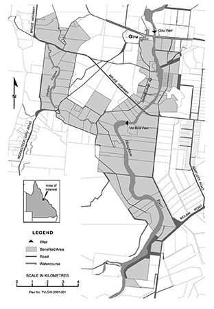
Giru Benefited Groundwater Area means the area shown on the map in schedule 3 as the Giru Benefited Groundwater Area.
hydraulic habitat requirements, of an ecological asset, are the hydraulic or physical attributes of the flow regime that are—
(a)required for a particular biological process or response to happen in relation to the asset; or
(b)necessary to maintain the long-term biological integrity of the asset.
IQQM computer program means the department’s Integrated Quantity and Quality Modelling computer program, and associated statistical analysis and reporting programs, that simulate daily stream flows, flow management, storages, releases, instream infrastructure, water diversions, water demands and other hydrologic events in the plan area.
maximum rate, for a water licence, means the maximum volume of water, in megalitres, that may be taken under the licence during a day.
sch 10 def maximum rate ins 2017 SL No. 7 s 41(2)
mean annual flow, for a node, means the total volume of flow, at the node, in the simulation period divided by the number of years in the simulation period.
median annual flow, for a node, means the annual flow volume, at the node, that is equalled or exceeded in 50% of years in the simulation period.
mining includes prospecting or exploring—
(a)under the Mineral Resources Act 1989 or another Act relating to mining; and
(b)on land to which a mining tenement under the Mineral Resources Act 1989 relates.
monthly supplemented water sharing index, for water allocations to take supplemented water in a particular priority group, means the percentage of months in the simulation period in which the allocations are fully supplied.
node see section 9.
operator of infrastructure for interfering with water, for part 6, means—
(a)the holder of a resource operations licence or a distribution operations licence; or
(b)an operator of infrastructure for interfering with water, mentioned in the resource operations plan.
operator of infrastructure for interfering with water ...
sch 10 def operator of infrastructure for interfering with water om 2017 SL No. 7 s 41(1)
period of no flow, for a node, means a period in which the watercourse has ceased to flow at the node.
per-second rate, for a water entitlement, means the maximum volume of water, in litres, that may be taken under the entitlement each second.
sch 10 def per-second rate ins 2017 SL No. 7 s 41(2)
plan area means the area shown as the plan area on the map in schedule 1.
pre-development flow pattern means the pattern of water flows, during the simulation period, decided by the chief executive using the IQQM computer program as if—
(a)there were no dams or other water infrastructure in the plan area; and
(b)no water was taken under authorisations in the plan area.
prescribed authorisation, for part 5, division 6, see section 54(1).
sch 10 def prescribed authorisation ins 2019 SL No. 120 s 57(2)
project of regional significance means a project the chief executive, having regard to the following, considers to be significant for a region in the plan area—
(a)the outcomes stated in part 3;
(b)the economic or social impact the project will have on the region;
(c)the public interest and the welfare of people in the region;
(d)another matter the chief executive considers relevant.
sch 10 def project of regional significance ins 2017 SL No. 7 s 41(2)
related development permit, for an authorisation, means the development permit for the works for taking water under the authorisation.
resource operations plan ...
sch 10 def resource operations plan amd 2016 SL No. 216 s 146 sch 20
om 2017 SL No. 7 s 41(1)
seasonality, for a flow at a point in a watercourse, means the time of year when the flow happens.
simulated mean annual diversion, for an authorisation or group of authorisations, means the total volume of water simulated to have been taken under the authorisations, if the authorisations were in existence for the whole of the simulation period, divided by the number of years in the simulation period.
simulation period means the period from 1 January 1890 to 31 December 2004.
started, for existing overland flow works, means—
(a)construction of the works had physically begun or, if construction had not physically begun, a contract had been entered into to begin construction; and
(b)an independently verifiable construction program existed for progressive construction towards completion of the works; and
(c)detailed design plans existed showing, among other things, the extent of the works; and
(d)if a permit under the Local Government Act 1993, section 940, was required for the works—the permit had been issued; and
(e)if a development permit was required for the works—the permit had been given.
State purpose means—
(a)a coordinated project; or
(b)a project of regional significance; or
(c)town water supply purposes.
sch 10 def State purpose ins 2017 SL No. 7 s 41(2)
subcatchment area see section 5(1).
sch 10 def subcatchment area amd 2019 SL No. 120 s 57(4)
SunWater reserve ...
sch 10 def SunWater reserve om 2017 SL No. 7 s 41(1)
supplementation point, for a watercourse, means the most upstream point on the watercourse at which the natural flow of water in the watercourse is supplemented by water from a dam or weir.
supplemented water means water supplied under an interim resource operations licence, resource operations licence or other authority to operate water infrastructure.
surface water means water in a watercourse, waterhole, lake or spring.
sch 10 def surface water ins 2019 SL No. 120 s 57(2)
this plan means this water resource plan.
trading zone, for a water allocation to which this plan applies, see section 7B.
sch 10 def trading zone ins 2019 SL No. 120 s 57(2)
unsupplemented water means water that is not supplemented water.
volumetric limit, for a water licence, means the maximum volume of water, in megalitres, that may be taken under the licence during a water year.
sch 10 def volumetric limit ins 2017 SL No. 7 s 41(2)
water allocation zone see section 7(1).
sch 10 def water allocation zone ins 2019 SL No. 120 s 57(2)
water flow season means any of the following periods in a year—
(a)the period from 1 January to 31 March (January–March water flow season);
(b)the period from 1 April to 30 June (April–June water flow season);
(c)the period from 1 July to 30 September (July–September water flow season);
(d)the period from 1 October to 31 December (October–December water flow season).
waterhole means a part of a watercourse that contains water after the watercourse ceases to flow, other than a part of a watercourse that is within the storage area of a dam on the watercourse.
water licence zone see section 7A.
sch 10 def water licence zone ins 2019 SL No. 120 s 57(2)
water management area ...
sch 10 def water management area om 2019 SL No. 120 s 57(1)
water management area zone ...
sch 10 def water management area zone ins 2017 SL No. 7 s 41(2)
om 2019 SL No. 120 s 57(1)
water management protocol means the water management protocol to implement this plan.
sch 10 def water management protocol ins 2017 SL No. 7 s 41(2)
water storage condition, of a water licence, means a condition requiring water taken under the licence to be stored in works used to take overland flow water.
sch 10 def water storage condition ins 2017 SL No. 7 s 41(2)
works that allow the taking of overland flow water include—
(a)storages, sumps, drains, embankments, channels and pumps for taking, or that can be used for taking, overland flow water; and
(b)storages that are connected to the works mentioned in paragraph (a); and
(c)works that make, or that can be used to make, the original connection between the storages mentioned in paragraph (b) and the works mentioned in paragraph (a).