


This plan may be cited as the Water Plan (Border Rivers and Moonie) 2019.
The purposes of this plan are to—(a)define the availability of water to which this plan applies; and(b)provide a framework for sustainably managing water to which this plan applies; and(c)identify priorities and mechanisms for dealing with the future water requirements in the plan area; and(d)provide a framework for managing water allocations; and(e)provide a framework for reversing, where practicable, the degradation of natural ecosystems caused by the taking of, or interference with, water to which this plan applies.
The dictionary in schedule 15 defines particular words used in this plan.
Surface water is—(a)water in a watercourse or lake; or(b)water in a spring not connected to water to which the Water Plan (Great Artesian Basin and Other Regional Aquifers) 2017 applies; or(c)overland flow water, other than water in a spring connected to water to which the Water Plan (Great Artesian Basin and Other Regional Aquifers) 2017 applies.
5References to latitudes and longitudes
(1)The latitudes and longitudes used to describe a location mentioned in this plan are worked out using GDA94.(2)In this section—GDA94 means the Geocentric Datum of Australia, commonly called ‘GDA 94’, notified in the Commonwealth Government Gazette No. GN 35 on 6 September 1995, at page 3369.
6Water to which plan applies—Act, s 43
For section 43(1)(a) of the Act, this plan applies to the following water in the plan area—(a)surface water;(b)underground water to which the Water Plan (Great Artesian Basin and Other Regional Aquifers) 2017 does not apply.
7Underground water declared to be overland flow water—Act, s 1006A
(1)For section 1006A(1) of the Act, underground water to which this plan applies is declared to be overland flow water if the underground water is—(a)from the Border Rivers Fractured Rock in the Granite Belt underground water sub-area; andThe Border Rivers Fractured Rock is an underground water unit.(b)not more than 6m below the surface.(2)Subsection (1) does not apply to underground water the chief executive is satisfied is not hydraulically connected to overland flow water.
(1)This plan applies to the area shown as the plan area on the map in schedule 1, part 1.(2)The plan area is divided into catchments.(3)A reference in this plan to a catchment by name is a reference to the catchment given that name on the map in schedule 1, part 1.
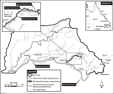
9Water supply schemes and water supply scheme zones
(1)Each part of the plan area shown as a water supply scheme on the map in schedule 2, part 1 is a water supply scheme for this plan.(2)Each part of the plan area shown as a water supply scheme zone on the map in schedule 2, part 1, and named and described in schedule 2, part 2, columns 2 and 3, is a water supply scheme zone.
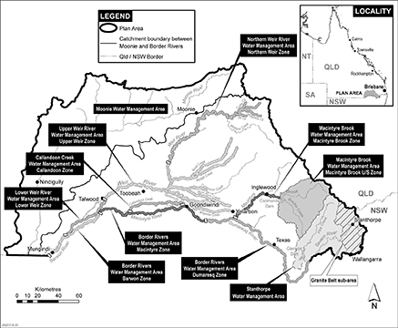
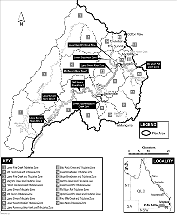
10Water management areas—Act, sch 4
(1)For schedule 4 of the Act, definition water management area, paragraph (b), each part of the plan area shown as a water management area on a map in schedule 3 is a water management area.(2)A reference in this plan to a water management area by name is a reference to the water management area given that name on a map in schedule 3 and in column 1 of a table in schedule 3.(3)For this section—(a)the Border Rivers water management area is the area labelled on the map in schedule 3, part 1, division 1 as—(i)the Border Rivers water management area Dumaresq zone; and(ii)the Border Rivers water management area Macintyre zone; and(iii)the Border Rivers water management area Barwon zone; and(b)the Macintyre Brook water management area is the area labelled on the map in schedule 3, part 1, division 1 as—(i)the Macintyre Brook water management area Macintyre Brook upstream zone; and(ii)the Macintyre Brook water management area Macintyre Brook zone.
(1)A water management area has 1 or more water management area zones.(2)Each part of the plan area shown as a water management area zone on a map in schedule 3, and named and described in columns 2 and 3 of a table in schedule 3, is a water management area zone.(3)A reference in this plan to a water management area zone by name is a reference to the water management area zone given that name on a map in schedule 3 and in column 2 of a table in schedule 3.
12Underground water management area
The part of the plan area shown as the underground water management area on the map in schedule 4 is the underground water management area.
(1)Certain parts of the underground water management area are divided into underground water sub-areas.(2)A part of the underground water management area shown on the map in schedule 5 as an underground water sub-area is an underground water sub-area.(3)A reference in this plan to an underground water sub-area by name is a reference to the underground water sub-area given that name in schedule 5.
14Underground water units and underground water sub-units
(1)The underground water management area includes the following aquifers (each an underground water unit)—(a)the Border Rivers Fractured Rock;(b)the Border Rivers Alluvium;(c)the St George Alluvium (shallow);(d)the St George Alluvium (deep);(e)the sediments above the Great Artesian Basin;(f)the Queensland Murray-Darling Basin deep.(2)The Border Rivers Alluvium, in the Border Rivers Alluvium underground water sub-area, is made up of the following aquifers (each an underground water sub-unit)—(a)for underground water to which this plan applies above the aquitard in the Border Rivers Alluvium—the Border Rivers Alluvium (shallow);(b)for underground water to which this plan applies below the aquitard in the Border Rivers Alluvium—the Border Rivers Alluvium (deep).
(1)Certain underground water sub-areas are divided into underground water zones.(2)A part of an underground water sub-area, shown on the map in schedule 6 as an underground water zone, is an underground water zone.
For section 43(1)(e)(i) of the Act, the following zones are trading zones for water allocations to which this plan applies—(a)a water supply scheme zone;(b)a water management area zone;(c)an underground water zone.
(1)A node is a point in the plan area.(2)The modelled location of each node is identified, by a letter, on the map in schedule 1, part 1 and is described in schedule 1, part 2.(3)A node may be referred to in this plan by its letter.(4)The actual location of each node is set by—(a)for nodes A to K—the eWater Source computer program; or(b)for nodes L to N—the MODFLOW computer program.
The exact location of the boundaries of each of the following is held in digital electronic form by the department and may be accessed at each office of the department—(a)the plan area;(b)a water supply scheme;(c)a water supply scheme zone;(d)a water management area;(e)a water management area zone;(f)the underground water management area;(g)an underground water sub-area;(h)an underground water zone.The location of each office of the department is available on the department’s website.
This part states, for section 43(1)(b) of the Act, the water plan outcomes for this plan.
A water plan outcome for this plan is that water to which this plan applies is to be allocated and managed in a way that—(a)recognises the natural state of watercourses, lakes, springs and aquifers has changed because of the taking of, or interference with, water; and(b)is consistent with the relevant version of the Basin Plan, including, for example, the sustainable diversion limits; and(c)is consistent with water sharing agreements and commitments between the State and New South Wales; and(d)seeks to achieve a balance between—(i)the economic water plan outcomes stated in section 21; and(ii)the social water plan outcomes stated in section 22; and(iii)the cultural water plan outcomes stated in section 23; and(iv)the environmental water plan outcomes stated in section 24; and(e)promotes improved understanding of—(i)matters affecting the flow-related, and underground water dependent, health of ecosystems, including springs, in the plan area; and(ii)the flow requirements of ecosystems in the plan area; and(iii)the water required for social, spiritual, economic, environmental and cultural uses of water by Aboriginal people; and(iv)the water required to deliver social and economic benefits to communities in the plan area; and(v)the impact of climate change on water availability; and(vi)the actions required to reverse the degradation of natural ecosystems caused by the taking of, or interference with, water to which this plan applies.
21Water plan outcomes—economic
(1)The economic water plan outcomes for this plan are—(a)to maintain the probability of being able to take water to which this plan applies under a water entitlement; and(b)to maintain and, if possible, improve the productive base of underground water to which this plan applies; and(c)to improve and support the effective and efficient operation of the market in water allocations and relocatable water licences; and(d)to maintain the availability of water to which this plan applies for stock purposes and tourism in the plan area; and(e)to maintain the availability of water to which this plan applies for industries dependent on water resources in the plan area; and(f)to maintain and, if possible, improve flood flows to support grazing activities in the plan area; and(g)to make water to which this plan applies available to support the economic and social aspirations of Aboriginal people.(2)In this section—relocatable water licence means a water licence that the water management protocol for this plan states may be relocated, in whole or in part, under section 126(1)(a) of the Act.
The social water plan outcomes for this plan are—(a)to maintain—(i)the availability of water to which this plan applies for the supply of urban water to towns and communities dependent on the water resources of the plan area; and(ii)the flows of water to which this plan applies that support water-related aesthetic, cultural and recreational values; and(b)to provide water to which this plan applies for domestic purposes in the plan area.
23Water plan outcomes—cultural
The cultural water plan outcomes for this plan are to maintain flows of water to which this plan applies that support the water-related cultural, spiritual, social and environmental values of Aboriginal people.
24Water plan outcomes—environmental
(1)The environmental water plan outcomes for this plan are—(a)to maintain the probability of being able to take surface water to which this plan applies under a water entitlement held only for providing benefit to the environment; andExamples of a water entitlement held only for providing benefit to the environment—
•a water entitlement held by CEWH•a water entitlement held only for protecting and restoring the health of Murray-Darling Basin ecosystems(b)to maintain and, if possible, improve flows of water to which this plan applies that support—(i)waterholes as refugia; and(ii)river channels; and(iii)river-forming processes; and(c)to maintain and, if possible, improve flows of water to which this plan applies that support floodplain ecosystems within and downstream of the plan area, including—(i)the Macintyre River floodplain downstream of Goondiwindi; and(ii)channel-connected wetlands associated with that floodplain; and(d)to minimise changes to flows of water in the plan area that support fish movement and fish recruitment; and(e)to minimise adverse environmental impacts, relating to water to which this plan applies, caused by the operation of infrastructure in the plan area; andExamples of adverse environmental impacts—
bank erosion, thermal alteration of waters, degradation of water quality(f)to minimise water quality degradation in relation to—(i)for surface water to which this plan applies—flow; and(ii)for underground water to which this plan applies—flow and pressure; and(g)to maintain an underground water regime in the plan area that supports ecosystems dependent on underground water to which this plan applies.(2)In this section—fish recruitment means the successful development and growth of a juvenile fish to a stage at which the fish has the ability to reproduce.underground water regime means the profile of underground water levels, hydraulic head and direction of underground water flow as represented by water levels at nodes L, M and N.waterhole means a part of a watercourse that contains water after the watercourse stops flowing, other than a part of the watercourse that is within the storage area of a dam or weir on the watercourse.
25General measures that contribute to achieving water plan outcomes
(1)Measures that contribute to achieving the water plan outcomes stated in sections 20(b), 21(1)(a) and (b), 23 and 24(1)(a) to (d), (f) and (g) are—(a)all water allocations are measured, as directed by the chief executive, by 31 December 2022; and(b)all water licences to take underground water to which this plan applies in the following underground water units are measured, as directed by the chief executive, by 31 December 2025—(i)the Border Rivers Fractured Rock;(ii)the Border Rivers Alluvium; and(c)all relevant taking of overland flow water is measured, as directed by the chief executive, by 31 December 2022.(2)A measure that contributes to achieving the water plan outcome stated in section 20(b) is the annual publication, by the chief executive, of a water use report that includes information about compliance with the sustainable diversion limits.(3)A measure that contributes to achieving the water plan outcomes stated in sections 20(b) and 21(1)(a) is the identification, by the chief executive by 30 June 2024, of works associated with the taking of water, declared to be overland flow water under section 7, for purposes other than stock purposes or domestic purposes.(4)A measure that contributes to achieving the water plan outcome stated in section 20(c) is each determination of environmental share made by the chief executive is recorded and published at least annually.(5)A measure that contributes to achieving the water plan outcome stated in section 21(1)(e) is the granting, by the chief executive within 5 years of the commencement, of water entitlements for the taking of unallocated water, reserved in the Stanthorpe water management area under this plan for the purpose of ‘any’, for achieving that water plan outcome.(6)A measure that contributes to achieving the water plan outcomes stated in sections 20 to 24 is that a monitoring, evaluation and reporting strategy, to support assessment of the effectiveness of this plan and its implementation, is developed by the chief executive by 1 July 2020.(7)In this section—environmental share means environmental share of water to which this plan applies under access arrangements for unsupplemented surface water in water sharing agreements and commitments between the State and New South Wales.relevant taking, of overland flow water, means taking of overland flow water—(a)permitted under section 39(1)(a) or (c); and(b)in any of the following water management area zones—(i)the Barwon zone;(ii)the Callandoon zone;(iii)the Lower Weir zone;(iv)the Upper Weir zone;(v)the Macintyre zone;(vi)zone A in the Moonie water management area;(vii)zone B in the Moonie water management area;(viii)zone C in the Moonie water management area;(ix)zone D in the Moonie water management area.
26Measures that contribute to achieving particular economic water plan outcomes
Measures that contribute to achieving the water plan outcome stated in section 21(1)(c) are—(a)information about the number, value and volume of water entitlement trades is collected and analysed; and(b)opportunities to improve the effectiveness and efficiency of the market in tradeable water entitlements are analysed; and(c)the information and analysis mentioned in paragraphs (a) and (b) are published by the chief executive within 5 years of the commencement; and(d)the establishment by the chief executive, within 2 years of the commencement, of a process for the granting of water entitlements for the taking of unallocated water, reserved in the Stanthorpe water management area under this plan, for achieving the water plan outcome mentioned in section 21(1)(g).See section 43 for unallocated water reserved under this plan.
27Measure that contributes to achieving particular cultural water plan outcomes
A measure that contributes to achieving the water plan outcomes stated in sections 20(e)(iii) and 23 is the publishing by the chief executive, within 5 years of the commencement, of a report on the flow requirements to support cultural values and uses, informed by engagement with Aboriginal people.
28Environmental flow objectives and performance indicators for surface water—Act, s 43
(1)For section 43(1)(d) of the Act, the environmental flow objectives for surface water to which this plan applies are stated in schedule 7, part 1.(2)The performance indicators for the environmental flow objectives for surface water to which this plan applies are stated in schedule 7, part 1.
29Environmental flow objectives and performance indicators for underground water—Act, s 43
(1)For section 43(1)(d) of the Act, the environmental flow objectives for underground water to which this plan applies are stated in schedule 7, part 2.(2)The performance indicators for the environmental flow objectives for underground water to which this plan applies are stated in schedule 7, part 2.
30Water allocation security objectives and performance indicators for surface water—Act, s 43
(1)For section 43(1)(e)(ii) of the Act, the water allocation security objectives for surface water to which this plan applies are that—(a)the performance ratio, for the high priority group, is not less than what the performance ratio for the group was immediately before the commencement; and(b)the performance ratio, for the medium priority group, is not less than what the performance ratio for the group was immediately before the commencement; and(c)the performance ratio, for each water allocation group mentioned in schedule 8, column 3, is not less than 99% of what the performance ratio for the group was immediately before the commencement.(2)The performance indicators for the water allocation security objectives for surface water to which this plan applies are the performance ratios for each group of water allocations mentioned in subsection (1).(3)In this section—high priority group means all water allocations that state they are in the ‘high priority group’.medium priority group means all water allocations that state they are in the ‘medium priority group’.
31Water allocation security objective and performance indicator for underground water—Act, s 43
(1)For section 43(1)(e)(ii) of the Act, the water allocation security objective for underground water to which this plan applies is that the annual announcement volume probability, for a water allocation group mentioned in schedule 9, column 1, is at least the percentage stated for the group in schedule 9, column 3.(2)The performance indicator for the water allocation security objective for underground water to which this plan applies is the annual announcement volume probability for each water allocation group mentioned in schedule 9, column 1.
32Calculation of performance indicators for surface water
(1)A performance indicator mentioned in section 28 or 30 must be calculated on the assumption that unallocated water reserved under this plan is being taken.See section 43 for unallocated water reserved under this plan.(2)Subsection (3) applies in relation to a decision made by the chief executive under chapter 2 of the Act—(a)that will result in the addition of a water allocation to, or the omission of a water allocation from, a priority group or a water allocation group; or(b)to approve an application under section 159 of the Act to change a water allocation.(3)In assessing the consistency of the decision with the water allocation security objectives for surface water, the performance indicators mentioned in section 30 must be calculated on the assumption the water allocation being added, omitted or changed is not part of a priority group or a water allocation group.
33Garden size and volume of water for watering—Act, s 6
(1)For section 6(3)(a) of the Act, a combined garden size of 0.25ha is stated for this plan.(2)For section 6(3)(b) of the Act, the volume of water that is sufficient to water a garden, with a combined size not exceeding 0.25ha, in the plan area is 2ML a year.
In this part—decision means a decision made by the chief executive under chapter 2 of the Act about the allocation or management of water to which this plan applies, other than a decision about a water permit.
35Decisions must not increase amount of water taken
(1)A decision must not increase—(a)the average volume of surface water or underground water that may be taken under this plan; or(b)the combined total of each nominal entitlement for water licences to take underground water to which this plan applies, other than water licences to which water sharing rules apply.(2)Subsection (1) does not apply to a decision about—(a)the reinstatement of a water licence; or(b)taking unallocated water reserved under this plan; orSee section 43 for unallocated water reserved under this plan.(c)taking or interfering with underground water to which this plan applies that is not in an underground water unit.
36Particular decisions must be consistent with particular objectives
A decision must be consistent with—(a)for a decision about the allocation or management of surface water to which this plan applies—(i)the environmental flow objectives stated in section 28(1); and(ii)the water allocation security objectives stated in section 30(1); or(b)for a decision about the allocation or management of underground water to which this plan applies—(i)the environmental flow objectives stated in section 29(1); and(ii)the water allocation security objective stated in section 31(1).
37Assessing consistency with particular objectives
(1)To assess the consistency of a decision with the environmental flow objectives for surface water or underground water to which this plan applies, or with the water allocation security objectives for surface water to which this plan applies, the model computer program’s simulation for the simulation period must be used.(2)To assess the consistency of a decision with the water allocation security objective for underground water to which this plan applies, the Border Rivers Alluvium (deep) decision support tool must be used.(3)If it is not practicable to use the model computer program’s simulation, or the Border Rivers Alluvium (deep) decision support tool, another kind of assessment approved by the chief executive may be used.(4)In this section—model computer program means—(a)the eWater Source computer program; or(b)the MODFLOW computer program; or(c)the statistical analysis and reporting programs associated with a computer program mentioned in paragraph (a) or (b).
38Limitations on taking water for particular activities—Act, s 101
(1)For section 101(1) of the Act—(a)the combined total amount of water to which this plan applies that may be taken for all activities prescribed under section 101(1)(a) of the Act is 2ML a year; and(b)a person must not take water to which this plan applies for an activity prescribed under section 101(1)(a) of the Act unless the water is taken using existing works.(2)Subsection (1)(b) does not apply to underground water to which this plan applies taken from the following underground water units—(a)the St George Alluvium (shallow);(b)the sediments above the Great Artesian Basin;(c)the Queensland Murray-Darling Basin deep.(3)In this section—existing works means works—(a)that are used, or capable of being used, to take or interfere with water; and(b)to which 1 of the following applies—(i)the works were constructed before the commencement;(ii)for works used, or capable of being used, to take or interfere with underground water to which this plan applies—the works are a replacement water bore that replaces works mentioned in subparagraph (i);(iii)for works used, or capable of being used, to take or interfere with surface water—the works replace works mentioned in subparagraph (i).
39Limitations on taking overland flow water—Act, s 101
(1)For section 101(1) of the Act, a person must not, under section 101(1)(b) of the Act, take overland flow water to which this plan applies unless the water—(a)is taken under a water entitlement or water permit; or(b)is taken for stock purposes or domestic purposes; or(c)is taken using—(i)existing overland flow works located in the Granite Belt underground water sub-area; or(ii)notified existing overland flow works located in the plan area, other than in the Granite Belt underground water sub-area.See also section 101(3) of the Act for when a person cannot be prevented from taking overland flow water that is contaminated agricultural run-off.(2)However, subsection (1)(c) does not apply to the person if the person holds a water licence to take the overland flow water using the works.
40Limitations on taking or interfering with underground water in underground water management area—Act, s 101
(1)For section 101(1) of the Act, a person must not, under section 101(1)(c) of the Act, take or interfere with underground water to which this plan applies, from an underground water unit, unless the water is taken or interfered with—(a)under a water entitlement or water permit; or(b)under a seasonal water assignment notice; or(c)for stock purposes or domestic purposes; or(d)for relevant underground water—using existing underground water works.(2)Subsection (1)(c) is subject to section 41.(3)In this section—existing underground water works means works used, or capable of being used, to take or interfere with underground water to which this plan applies if—(a)for underground water from the Border Rivers Fractured Rock in the Granite Belt underground water sub-area—(i)the works were constructed before 6 July 2016; or(ii)otherwise—(A)construction of the works was physically started before 6 July 2016 and was completed before 31 December 2016; and(B)the chief executive was, before 17 August 2016, given a notice for the works under item 5(c) of the moratorium notice, published on 6 July 2016, called ‘Moratorium notice Water Act 2000 Granite Belt underground water area’; orThe Border Rivers Fractured Rock is an underground water unit.(b)for underground water from the Queensland Murray-Darling Basin deep—the works were constructed before the commencement; orThe Queensland Murray-Darling Basin deep is an underground water unit.(c)the works are a replacement water bore that replaces works mentioned in paragraph (a) or (b).relevant underground water means underground water to which this plan applies from—(a)the Border Rivers Fractured Rock in the Granite Belt underground water sub-area; or(b)the Queensland Murray-Darling Basin deep.The Border Rivers Fractured Rock and the Queensland Murray-Darling Basin deep are underground water units.
41Taking or interfering with underground water from land in service area for stock purposes or domestic purposes
(1)This section applies to underground water to which this plan applies if the water is—(a)taken or interfered with, for stock purposes or domestic purposes, on land in a service area; and(b)taken from either of the following underground water units—(i)the Border Rivers Alluvium;(ii)the Border Rivers Fractured Rock.(2)The water may only be taken or interfered with using existing underground water works.(3)In this section—existing underground water works means works used, or capable of being used, to take or interfere with underground water to which this plan applies if—(a)the works were—(i)used, or capable of being used, to take underground water for stock purposes or domestic purposes immediately before the commencement; and(ii)for works used, or capable of being used, to take or interfere with underground water from the Border Rivers Alluvium—(A)constructed before 19 December 2014; or(B)constructed in accordance with an agreement entered into between the person and the chief executive between 19 December 2014 and 18 January 2015; andThe Border Rivers Alluvium is an underground water unit.(b)the works are a replacement water bore that replaces works mentioned in paragraph (a).service area means a service area for a retail water service to customers under the Water Supply (Safety and Reliability) Act 2008.
42Volume of limited capacity for contaminated agricultural run-off
(1)For State code 10 of the State development assessment provisions, the volume of the limited capacity of contaminated agricultural run-off to which this plan applies is 1ML.(2)In this section—State development assessment provisions see the Planning Regulation 2017, schedule 24.
43Unallocated water reserved under this plan—Act, s 43
For section 43(1)(c) of the Act, the volume of unallocated water reserved under this plan is—(a)for surface water to which this plan applies in a water management area mentioned in schedule 10, part 1, column 1—the average annual volume of water stated in schedule 10, part 1, column 2 for the area; and(b)for underground water to which this plan applies in an underground water unit mentioned in schedule 10, part 2, column 2—the annual volume of water stated in schedule 10, part 2, column 3 for the underground water unit.
44Chief executive must not accept particular applications— Act, s 43
For section 43(2)(j) of the Act, the chief executive must not accept an application for a water licence made under section 107 of the Act unless the chief executive is permitted to accept the application under section 45 or 46.
45Particular applications made by local governments
(1)This section applies in relation to an application made by a local government under section 107 of the Act for a water licence to interfere with the flow of water to which this plan applies.(2)The chief executive may accept the application if—(a)the purpose of the proposed interference is to impound water to enable the taking of water under a water allocation held by the local government to supply town water; and(b)either—(i)the local government has made a relevant change application to the chief executive; or(ii)the chief executive has approved a relevant change application made by the local government and has given a certificate, for the dealing to which the application relates, to the local government under section 159(4) of the Act.(3)If the chief executive grants the application mentioned in subsection (1), the water licence must include the conditions stated in the water management protocol for the licence.(4)In this section—relevant change application means an application, under section 159(1) of the Act, to change the water allocation mentioned in subsection (2)(a)—(a)to prevent an increase, due to the proposed interference mentioned in subsection (1), of the average volume of surface water or underground water that may be taken under this plan; and(b)to remove a condition stating a flow threshold for taking water; and(c)to ensure the water allocation is subject to a condition stating that only water impounded by the proposed interference may be taken.
46Applications for water licences to take overland flow water using particular existing overland flow works
(1)This section applies if—(a)the owner of land, on which works used to take overland flow water are situated, applies under section 107 of the Act for a water licence to take overland flow water to which this plan applies using the works; and(b)the works are located in the plan area, other than in the Granite Belt underground water sub-area.(2)The chief executive may accept the application if the chief executive is reasonably satisfied—(a)the works are existing overland flow works; and(b)for works other than notified existing overland flow works—the works were used to take overland flow water, other than for stock purposes or domestic purposes, before—(i)for works in the Border Rivers catchment—20 September 2000; or(ii)for works in the Moonie catchment—9 June 2001.See also section 39(1)(c) for when a person may take overland flow water using existing overland flow works.
47Particular applications for dealing with water licences inconsistent with this plan
(1)The granting of an application made under section 121 of the Act for a dealing with a water licence in relation to water to which this plan applies is inconsistent with this plan if, under section 130 of the Act, the application must be assessed as if it were an application for a new water licence.See section 129 of the Act for the actions the chief executive must take if the granting of an application for a dealing with a water licence is inconsistent with a water plan.(2)However, subsection (1) does not apply to the application if—(a)the application is made by a local government to allow for increased interference with the flow of water to which this plan applies; and(b)the purpose of the proposed increased interference is to impound water to enable the taking of water under a water allocation, held by the local government, to supply town water; and(c)either—(i)the local government has made a relevant change application to the chief executive; or(ii)the chief executive has approved a relevant change application made by the local government and has given a certificate, for the dealing to which the application relates, to the local government under section 159(4) of the Act.See section 130 of the Act for how an application mentioned in this subsection must be assessed.(3)Also, subsection (1) does not apply if the application is—(a)an application to amend a water licence to take underground water to change the location from which water may be taken under the licence; or(b)an application to amalgamate water licences to take underground water.(4)If the chief executive grants an application to which subsection (2) applies, the water licence to which the dealing relates must include the conditions stated in the water management protocol for the licence.(5)In this section—relevant change application means an application, under section 159(1) of the Act, to change the water allocation mentioned in subsection (2)(b)—(a)to prevent an increase, due to the proposed increased interference mentioned in subsection (2)(a), of the average volume of surface water or underground water that may be taken under this plan; and(b)to remove a condition stating a flow threshold for taking water; and(c)to ensure the water allocation is subject to a condition stating that only water impounded by the proposed increased interference may be taken.
48Water licences granted to authorise particular existing activities—Act, s 116
(1)This section applies if a water entitlement notice for this plan provides for the granting of a water licence to interfere with the flow of water to which this plan applies for the purpose of impounding water using works mentioned in schedule 11.(2)For section 116(1) of the Act, the chief executive must decide to grant the water licence.See also section 116(2) of the Act for when the chief executive may grant a water licence without the need for an application to be made under section 107 of the Act.
49Water licence granted to replace existing authority—Act, s 116
(1)This section applies if a water entitlement notice for this plan provides for the granting of a water licence to—(a)take underground water to which this plan applies; and(b)replace water permit number 615657.(2)For section 116(1) of the Act, the chief executive must decide to grant the water licence.See also section 116(2) of the Act for when the chief executive may grant a water licence without the need for an application to be made under section 107 of the Act.
In this subdivision—ancillary water licence see section 51(1)(d).impounded water see section 51(1)(a).licence to interfere means a water licence stated in schedule 12, column 1.
51Grant of ancillary water licences to particular persons—Act, s 116
(1)This section applies if—(a)water (impounded water) to which this plan applies is impounded under a licence to interfere; and(b)an existing authorisation, stated in schedule 12, column 2 opposite the licence to interfere, is converted, under section 72, to a converted water allocation that is subject to the conditions mentioned in section 75(2)(b); and(c)before it was converted, the existing authorisation authorised the taking of some or all of the impounded water; and(d)a water entitlement notice for this plan provides for the granting of a water licence (an ancillary water licence) to take the impounded water to the holder of the converted water allocation.(2)For section 116(1) of the Act, the chief executive must decide to grant the ancillary water licence.See also section 116(2) of the Act for when the chief executive may grant a water licence without the need for an application to be made under section 107 of the Act.
52Content and conditions of ancillary water licence
The ancillary water licence must—(a)state—(i)the purpose for which impounded water may be taken under the ancillary water licence as ‘any’; and(ii)the maximum rate at which impounded water may be taken under the ancillary water licence, in megalitres a day; and(iii)the volumetric limit for the ancillary water licence; and(b)be subject to—(i)a condition that impounded water taken under the ancillary water licence must not be stored; and(ii)a condition that impounded water taken under the ancillary water licence must be taken only from the impoundment authorised under the licence to interfere.
(1)This section applies for working out, for section 52(a)(ii), the maximum rate at which impounded water may be taken under the ancillary water licence.(2)The maximum rate is—(a)subject to paragraph (c), if the existing authorisation stated a rate for taking the water—the stated rate; or(b)subject to paragraph (c), if a development permit related to the existing authorisation states a pump size—(i)for a stated pump size of 32mm—0.5ML a day; or(ii)for a stated pump size of 125mm—7.3ML a day; or(iii)for a stated pump size, other than 32mm or 125mm, mentioned in the Water Regulation 2016, schedule 7, column 1—the rate stated in schedule 7, column 2 of that regulation for the pump size; or(iv)otherwise—the rate decided by the chief executive having regard to—(A)the rates stated in subparagraphs (i) and (ii); and(B)the rates stated for similar pump sizes, other than 32mm or 125mm, in the Water Regulation 2016, schedule 7, column 2; or(c)if paragraphs (a) and (b) both apply—the lesser of the following rates—(i)the rate decided under paragraph (a);(ii)the rate decided under paragraph (b); or(d)otherwise—the rate worked out by the chief executive having regard to—(i)the purpose stated in any existing authorisation that was previously held by the licensee; and(ii)the rate at which the chief executive estimates water was able to be taken under the existing authorisation mentioned in subparagraph (i).
For section 52(a)(iii), the volumetric limit for the ancillary water licence is the volumetric limit stated in schedule 12, column 3 opposite the existing authorisation.
55Authority of ancillary water licence
To remove any doubt, the authority to take water under the ancillary water licence is in addition to, and does not affect, the authority of the holder of the converted water allocation to take water under the allocation.
56Content and conditions of water licences to take overland flow water
(1)A water licence to take overland flow water to which this plan applies must—(a)state the purpose for which the water may be taken as ‘any’; and(b)include at least 1 of the following—(i)the maximum rate at which the water may be taken under the water licence;(ii)the maximum storage capacity of works that may be used to store the water taken under the water licence;(iii)the average annual volume of water that may be taken under the water licence;(iv)the volumetric limit for the water licence.(2)The water licence may also include the following conditions—(a)a limit on the volume of the water that may be taken in a stated period;(b)a limit on the volume of the water that may be stored.
(1)This section applies for working out, for section 56(1)(b)(i), the maximum rate at which overland flow water may be taken.(2)The chief executive—(a)if a certified report for the works that will be used to take the overland flow water has been requested under section 62(4)(a)(iii)—must have regard to the certified report for the works given to the chief executive; and(b)may have regard to any other relevant information available to the chief executive.(3)If the chief executive works out the maximum rate having regard to the size of the pump that will be used to take the overland flow water, the maximum rate must not be greater than the rate stated in the Water Regulation 2016, schedule 7, column 3 for the pump size stated opposite in schedule 7, column 1 of that regulation.
58Working out maximum storage capacity
(1)This section applies for working out, for section 56(1)(b)(ii), the maximum storage capacity of works that may be used to store overland flow water.(2)The chief executive—(a)if a certified report for the works has been requested under section 62(4)(a)(iii)—must have regard to the certified report for the works given to the chief executive; and(b)may have regard to any other relevant information available to the chief executive.(3)However, the chief executive must disregard the storage capacity of—(a)bunded land; or(b)land used for irrigated or dryland agriculture; or(c)land surrounded by levees.See section 39(1)(c) for when a person may take overland flow water using existing overland flow works.(4)In this section—bunded land means land on which a permanent or temporary levee is constructed to divert overland flow water away from land used for agricultural or horticultural production.
59Working out average annual volume
(1)This section applies for working out, for section 56(1)(b)(iii), the average annual volume of overland flow water that may be taken.(2)The chief executive must have regard to—(a)the catchment characteristics for the water’s catchment; and(b)the maximum rate, if any, worked out under section 57, at which the overland flow water may be taken; and(c)the maximum storage capacity, if any, worked out under section 58, of the works that may be used to store the water; and(d)if overland flow water taken under the water licence is to be used to irrigate crops—the pattern of usage demand for the storage for the water licence; and(e)the extent to which the storage for the water licence may also be used to store water taken under another authorisation; and(f)the other conditions applying to the water licence.(3)In this section—catchment characteristics, for a catchment, means the characteristics of the catchment that affect the volume of overland flow water in the catchment, including, for example—(a)the area of the catchment; and(b)the slope of the catchment; and(c)the amount of rainfall that typically falls in the catchment; and(d)the amount and type of vegetation in the catchment.pattern of usage demand, for a storage, means the pattern of usage from the storage worked out having regard to—(a)how water, stored in or by the storage, is used to grow crops; and(b)the planting rule for the trading zone in which the storage is located.planting rule, for a trading zone, means the method used, in the IQQM computer program simulation, to work out the area under crops in the trading zone in the Border Rivers catchment.storage, for a water licence, means the works that will primarily be used to store the overland flow water taken under the water licence.trading zone means an area stated to be a trading zone for water allocations under this plan.
60Working out volumetric limit
(1)This section applies for working out, for section 56(1)(b)(iv), the volumetric limit for the water licence.(2)If an average annual volume, worked out under section 59, is a condition of the water licence, the chief executive must have regard to that average annual volume.
61Criteria for deciding applications for water licences to take overland flow water using existing overland flow works—Act, s 43
(1)This section states, for section 43(2)(h) of the Act, the criteria for deciding an application for a water licence, to take overland flow water to which this plan applies using existing overland flow works, accepted by the chief executive under section 46(2).(2)The chief executive must decide to grant the application if the chief executive reasonably believes there has been, or may be, an increase in the average annual volume of overland flow water taken using the works above the average annual volume that could have been taken using the works under the relevant operating arrangements for the works.(3)Despite subsection (2), the chief executive may refuse to grant the application if the chief executive considers the application should be refused having regard to the matters the chief executive must consider under section 113 of the Act.
62Process for allocation of overland flow water—Act, s 116
(1)This section states, for section 116(1) of the Act, a process for the allocation of overland flow water to which this plan applies under a water licence.See section 116(2) of the Act for when the chief executive may grant a water licence without the need for an application to be made under section 107 of the Act.(2)A water licence to take the water using existing overland flow works may be granted to the owner of the land on which the works are situated.(3)Without limiting subsection (2), a water licence to take the water using existing overland flow works must be granted to the owner of the land on which the works are situated if—(a)the works are notified existing overland flow works; and(b)the chief executive reasonably believes there has been, or may be, an increase in the average annual volume of overland flow water taken using the works above the average annual volume that could have been taken using the works under the relevant operating arrangements for the works.(4)The chief executive must, before granting the water licence under subsection (2) or (3)—(a)give the owner a notice—(i)identifying the works for which a water licence is proposed to be granted; and(ii)stating that a water licence is proposed to be granted for the taking of overland flow water to which this plan applies using the works; and(iii)if the chief executive requires further information about the works—requesting the owner give the chief executive, within a stated period, a certified report for the works; and(b)if a certified report for the works has been requested under paragraph (a)(iii)—have regard to a certified report for the works given to the chief executive.
63Water licences to include particular conditions
(1)This section applies to a water licence with an identifying number mentioned in schedule 13.(2)If, under section 70(1)(e) of the Act, a water entitlement notice for this plan provides for the water licence to be amended to be subject to a stated condition, the water licence is inconsistent with this plan unless the water licence is subject to the condition.See section 133(2) of the Act for the actions the chief executive must take if a water licence is inconsistent with a water plan.(3)For section 133(2) of the Act, the stated time is 60 business days after the making of the water entitlement notice.
64Water licences to take underground water to contain particular matters
(1)This section applies to a water licence to take underground water to which this plan applies in the underground water management area.(2)If, under section 70(1)(e) of the Act, a water entitlement notice for this plan provides for the water licence to be amended to state a relevant matter, the licence is inconsistent with this plan unless the relevant matter is stated in the licence.See section 133(2) of the Act for the actions the chief executive must take if a water licence is inconsistent with a water plan.(3)In this section—relevant matter means any of the following matters—(a)a condition to which the water licence is subject;(b)a purpose for which water to which this plan applies may be taken under the water licence;(c)a nominal entitlement for the water licence;(d)the underground water sub-area or the underground water zone to which the water licence relates;(e)if the water taken under the water licence must be from a particular underground water sub-unit—the underground water sub-unit;(f)if the water licence relocation rules apply to the water licence—the latitude and longitude for the point at which water to which this plan applies may be taken under the water licence.water licence relocation rules means the rules, stated in the water management protocol for this plan, about a dealing with a water licence to which section 126 of the Act applies.
65Water licences with stated purpose of irrigation
A water licence with the stated purpose of irrigation is inconsistent with this plan unless the water licence is subject to a condition that water taken under the water licence must not be stored.See section 133(2) of the Act for the actions the chief executive must take if a water licence is inconsistent with a water plan.
66Water licences authorising the taking of water in Glen Niven tributaries zone
(1)A water licence authorising the taking of water in the Glen Niven tributaries zone is inconsistent with this plan unless—(a)the purpose for which water may be taken under the water licence is stated in the water licence as ‘any’; and(b)if the water licence states an area that may be irrigated by water taken under the water licence—the area is removed from the water licence and replaced with an annual volumetric limit for taking water under the water licence, calculated by multiplying the area, in hectares, by 6; and(c)the water licence states the maximum rate at which water may be taken under the water licence.1See section 133(2) of the Act for the actions the chief executive must take if a water licence is inconsistent with a water plan.2The Glen Niven tributaries zone is a water management area zone.(2)If the water licence is amended to state a maximum rate at which water may be taken under the water licence, the maximum rate must be—(a)if a development permit that relates to the water licence states a pump size—(i)for a stated pump size of 32mm—0.5ML a day; or(ii)for a stated pump size of 125mm—7.3ML a day; or(iii)for a stated pump size, other than 32mm or 125mm, mentioned in the Water Regulation 2016, schedule 7, column 1—the rate stated in schedule 7, column 2 of that regulation for the pump size; or(iv)otherwise—the rate decided by the chief executive having regard to—(A)the rates stated in subparagraphs (i) and (ii); and(B)the rates stated for similar pump sizes, other than 32mm or 125mm, in the Water Regulation 2016, schedule 7, column 2; or(b)otherwise—the rate decided by the chief executive having regard to—(i)the purpose stated in the water licence; and(ii)the rate at which the chief executive estimates water is able to be taken under the water licence.
67Accounting period for water licences—Water Regulation 2016, s 142
For the Water Regulation 2016, section 142(a), the accounting period for a water licence to take water to which this plan applies is 1 July to 30 June in the following year.
68Water allocation groups—Act, sch 4
For schedule 4 of the Act, definition water allocation group, a group of water allocations is a water allocation group, for unsupplemented surface water, if each water allocation in the group—(a)states the same water allocation group mentioned in schedule 8, column 3 (the water allocation group identifier); and(b)authorises the taking of unsupplemented surface water—(i)in the water management area zone mentioned in schedule 8, column 1 opposite the water allocation group identifier; and(ii)from the water source mentioned in schedule 8, column 2 opposite the water allocation group identifier.
69Amending particular water allocations—Act, s 150
(1)This section applies to a water allocation with an identifying number mentioned in column 1 of an amendment table.(2)For section 150(1)(a) of the Act, the water allocation must be amended to ensure—(a)if column 2 of the amendment table states a water management area zone for the water allocation—the water management area zone for the water allocation is the stated water management area zone; and(b)if column 2 of the amendment table states a purpose for the water allocation—the purpose of the water allocation is the stated purpose; and(c)if column 2 of the amendment table states a water allocation group for the water allocation—the water allocation group for the water allocation is the stated water allocation group; and(d)if column 2 of the amendment table states a location from which water may be taken under the water allocation—water may only be taken under the water allocation from the stated location; and(e)if column 2 of the amendment table states ‘no conditions’—the only condition applying to the water allocation is a flow condition; and(f)if column 2 of the amendment table states a condition for the water allocation—the water allocation is subject to the stated condition or another condition that has the same effect as the stated condition.(3)To remove any doubt, it is declared that if an existing detail of, or condition imposed on, the water allocation is inconsistent with an amendment required under subsection (2), the existing detail or condition must be also amended or removed, but only to the extent necessary to avoid the inconsistency.(4)In this section—amendment table means a table in schedule 14, part 1 or 2.
In this subdivision—converted water allocation see section 72(1).Stanthorpe allocation means a converted water allocation to take unsupplemented surface water to which this plan applies from a watercourse, lake or spring in the Stanthorpe water management area, other than the Glen Niven tributaries zone.The Glen Niven tributaries zone is a water management area zone.Upper Weir allocation means a converted water allocation to take unsupplemented surface water to which this plan applies from Brigalow Creek, Commoron Creek, Murri Murri Creek or Yambocully Creek.
This subdivision states, for section 43(2)(g) of the Act, arrangements and processes for converting, under a water entitlement notice for this plan, particular authorisations to water allocations to take unsupplemented surface water to which this plan applies.
72Authorisations may be converted to water allocations
(1)A water entitlement notice may, under section 70(1)(a) of the Act, implement this plan by providing for the conversion of an existing authorisation to a water allocation stated in the notice (a converted water allocation) to take unsupplemented surface water to which this plan applies.(2)In this section—existing authorisation means—(a)water permit number 618275; or(b)water permit number 618282; or(c)a water licence that—(i)is in force at the commencement; and(ii)is a licence to take unsupplemented surface water to which this plan applies—(A)from a watercourse, lake or spring mentioned in column 1 of the following table; and(B)for the purpose stated in column 2 of the following table opposite the watercourse, lake or spring.
Column 1
Column 2
Watercourse, lake or spring
Purpose
a watercourse, lake or spring in the Stanthorpe water management area, other than the Glen Niven tributaries zone
any
a watercourse, lake or spring in the Macintyre Brook upstream zone
irrigation
Brigalow Creek, Commoron Creek, Murri Murri Creek or Yambocully Creek
water harvesting
The Glen Niven tributaries zone and the Macintyre Brook upstream zone are water management area zones.
The purpose for taking water under the converted water allocation must be ‘any’ or ‘urban’.
The location from which water may be taken under the converted water allocation must include the place from which water was permitted to be taken under the existing authorisation.
(1)In deciding the conditions on which water may be taken under the converted water allocation, the chief executive must have regard to—(a)the terms or conditions stated in the existing authorisation; and(b)if there were water sharing rules for the existing authorisation—the water sharing rules.(2)Subject to subsection (3), a Stanthorpe allocation must include the following conditions—(a)if the existing authorisation stated a limit for taking water—a condition that water taken under the Stanthorpe allocation must not be stored;(b)otherwise—(i)a condition that water must not be taken under the Stanthorpe allocation unless a flow in the watercourse, lake or spring is visible; and(ii)a condition that the accounting period for the Stanthorpe allocation is ‘multiyear’.(3)If subsection (2)(a) does not apply and the chief executive is reasonably satisfied the conditions mentioned in subsection (2)(b) should not be required for the Stanthorpe allocation, the Stanthorpe allocation must include the following conditions—(a)a condition that water taken under the Stanthorpe allocation must not be stored;(b)if the existing authorisation was subject to a condition limiting the taking of water from the impoundment for the existing authorisation—the same condition, modified as necessary;(c)otherwise—a condition ensuring water is only taken under the Stanthorpe allocation if the water level in the impoundment for the Stanthorpe allocation is above the minimum level for the impoundment.(4)Subsection (5) applies to an Upper Weir allocation if—(a)water taken under the existing authorisation could have been stored using works capable of being used to take overland flow water; and(b)no water licence authorises the taking of overland flow water using the works.(5)The Upper Weir allocation must include a condition that prohibits an increase in the volume of overland flow water taken using the works.(6)In this section—impoundment means an impoundment authorised under—(a)for an existing authorisation mentioned in section 51(1)(b) or a Stanthorpe allocation converted from an existing authorisation mentioned in section 51(1)(b)—the licence to interfere mentioned in schedule 1, column 1 for the existing authorisation; or(b)for water licence number 42967T or a Stanthorpe allocation converted from that water licence—water licence number 46090T.licence to interfere means a licence to interfere mentioned in section 51(1)(a).minimum level, for an impoundment, means 0.3m below full supply level of the impoundment.
(1)The nominal volume for a Stanthorpe allocation, other than a water allocation to take water to which this plan applies in Lower Severn River zone 2, is the volumetric limit for the Stanthorpe allocation.Lower Severn River zone 2 is a water management area zone.(2)The nominal volume for the following converted water allocations is the volume, in megalitres, calculated by multiplying the irrigated area for the existing authorisation, in hectares, by 6—(a)a Stanthorpe allocation to take water to which this plan applies in Lower Severn River zone 2;(b)a Macintyre Brook allocation.(3)The nominal volume for another converted water allocation is to be based on an assessment of the water taken under the existing authorisation.See also the Water Regulation 2016, section 46.(4)For the Water Regulation 2016, section 46(1)(e), the other criteria are—(a)the water sharing rules included in the water management protocol for this plan; and(b)the share of water determined, by the IQQM computer program simulation, to be available for Upper Weir allocations.(5)In this section—irrigated area, for an existing authorisation, means the area, stated in the existing authorisation, that was able to be irrigated by water taken under the existing authorisation.Macintyre Brook allocation means a converted water allocation to take unsupplemented surface water to which this plan applies from a watercourse, lake or spring in the Macintyre Brook upstream zone.The Macintyre Brook upstream zone is a water management area zone.
(1)The volumetric limit for the converted water allocation must be based on—(a)for a Stanthorpe allocation, other than a converted water allocation to take water to which this plan applies in Lower Severn River zone 2—(i)if the existing authorisation stated a limit for taking water—the limit; or(ii)if the existing authorisation stated an area that was able to be irrigated—the area; orLower Severn River zone 2 is a water management area zone.(b)otherwise—an assessment of water taken under the existing authorisation and the efficiency of the use of the water.See also the Water Regulation 2016, sections 47 to 49.(2)However, if subsection (1)(a)(i) and (ii) both apply in relation to the converted water allocation, the basis for calculating the volumetric limit is the basis mentioned in subsection (1)(a)(i) or (ii) that results in the lesser volumetric limit.(3)For the Water Regulation 2016, section 48, the factor is 6ML a hectare.(4)For the Water Regulation 2016, section 49(f), the other criterion is the share of water determined, by the IQQM computer program simulation, to be available for Upper Weir allocations.
78Maximum rate for taking water
(1)The maximum rate for the converted water allocation must be—(a)if the existing authorisation stated a maximum rate at which water was able to be taken under the existing authorisation—based on that maximum rate; or(b)if a development permit for the existing authorisation stated a pump size—(i)for a stated pump size of 32mm—0.5ML a day; or(ii)for a stated pump size of 125mm—7.3ML a day; or(iii)for another stated pump size—based on the pump size; or(c)otherwise—decided by the chief executive.See also the Water Regulation 2016, sections 50 to 52.(2)However, if subsection (1)(a) and (b) both apply in relation to the converted water allocation, the maximum rate for the converted water allocation must be based on the matter mentioned in subsection (1)(a) or (b) that results in the lesser maximum rate.(3)For the Water Regulation 2016, section 51(2), the maximum rate is to be in megalitres per day.(4)For the Water Regulation 2016, section 52(2)(c), the other criteria are—(a)the terms or conditions under which water was able to be taken under the existing authorisation; and(b)a condition of any other water entitlement, or any other authorisation, that limited the total rate for taking water under the existing authorisation.
79Water allocation groups—Act, sch 4
For schedule 4 of the Act, definition water allocation group, a group of water allocations is a water allocation group, for underground water, if each water allocation—(a)states the same water allocation group mentioned in schedule 9, column 1 (the water allocation group identifier); and(b)permits underground water to which this plan applies to be taken for the purpose mentioned in schedule 9, column 4 opposite the water allocation group identifier.
In this subdivision—converted water allocation see section 82(2).
This subdivision states, for section 43(2)(g) of the Act, arrangements and processes for converting, under a water entitlement notice for this plan, particular authorisations to water allocations to take underground water to which this plan applies.
82Authorisations may be converted to water allocations
(1)This section applies to a water licence that—(a)is in force on the commencement; and(b)is a licence to take underground water to which this plan applies—(i)from the Border Rivers Alluvium (deep); andThe Border Rivers Alluvium (deep) is an underground water sub-unit.(ii)for purposes other than stock purposes or domestic purposes; and(c)does not have a nominal entitlement of 0ML.(2)A water entitlement notice may, under section 70(1)(a) of the Act, implement this plan by providing for the conversion of the water licence to a water allocation stated in the notice (a converted water allocation) to take underground water to which this plan applies.
The purpose for taking water under the converted water allocation must be ‘any’ or ‘urban’.
(1)The chief executive must decide the location from which water may be taken under the converted water allocation having regard to—(a)the location of works used to take water under the existing authorisation; and(b)the centre of the land to which the existing authorisation attached.(2)The converted water allocation must state the latitude and longitude of the location from which water may be taken under the allocation.(3)Subsection (2) does not apply if the holder of the water allocation is CEWH.
In deciding the conditions on which underground water may be taken under the converted water allocation, the chief executive must have regard to the conditions stated in the existing authorisation.
The volumetric limit for the converted water allocation must be equal to the nominal entitlement stated in the existing authorisation.
The nominal volume for the converted water allocation must be decided by the chief executive having regard to the available water ratio stated in schedule 9, column 2 opposite the water allocation’s water allocation group.
88Requirement to make and keep records of contaminated agricultural run-off taken
(1)This section applies to a person who takes overland flow water to which this plan applies if—(a)the water is contaminated agricultural run-off; and(b)the person takes the contaminated agricultural run-off to comply with an obligation on the person under the Environmental Protection Act 1994.See section 101 of the Act.(2)The person must make a record of the following matters—(a)the volume of contaminated agricultural run-off taken;(b)the date and nature of the activity or event that caused the contaminated agricultural run-off;Examples of activities or events that may cause contaminated agricultural run-off—
rainfall, irrigation, spills(c)another matter stated for this section in the water management protocol for this plan.(3)The person must keep the record for 5 years.1See section 35 of the Act for when the chief executive may give a person authorised to take water under the Act a notice requiring information about the water taken under the person’s authority.2See section 760 of the Act for when an authorised officer may require a person to make available for inspection a document relating to the taking of water.
89Water management protocol—Act, s 43
(1)For section 43(2)(l) of the Act, a water management protocol must be prepared for the plan area.(2)The water management protocol must state the following matters for the plan area—(a)the volumes of unallocated water reserved for stated purposes or stated locations;(b)the criteria and process for deciding applications for a seasonal water assignment;(c)for water allocations managed under a resource operations licence—the water allocation dealing rules;(d)for water allocations not managed under a resource operations licence—(i)the seasonal water assignment rules; and(ii)the water allocation dealing rules; and(iii)the water sharing rules;(e)monitoring requirements for water and natural ecosystems.(3)The water management protocol may state the following matters for the plan area—(a)the criteria and process for deciding applications for relocation of a water licence;(b)the arrangements for interstate trading between the State and New South Wales;(c)a process for conducting an underground water impact assessment in relation to—(i)a proposed dealing with a water licence; or(ii)a proposed water allocation dealing.(d)a matter for which a record must be made and kept under section 88.(4)Subsections (2) and (3) do not limit the matters that may be stated in the water management protocol.(5)In this section—underground water impact assessment, in relation to a proposed dealing mentioned in subsection (3)(c)(i) or (ii), means an impact assessment carried out to work out whether the impact of approving the proposed dealing on holders of other water entitlements is unacceptable.
90Arrangements for interstate trading
In deciding the arrangements for interstate trading between the State and New South Wales mentioned in section 89(3)(b), the chief executive must ensure the arrangements are consistent with—(a)the water plan outcomes stated in part 3; and(b)the measures for achieving the water plan outcomes stated in part 4; and(c)the environmental flow objectives and water allocation security objectives stated in part 5.
91Amendments to plan that may be made without consultation—Act, s 43
For section 43(2)(m) of the Act, the following amendments may be made to this plan without public consultation—(a)an amendment or addition of an environmental flow objective or a water allocation security objective, or a performance indicator for an objective, if the amendment or addition achieves an equivalent or improved environmental flow and water allocation security outcome;(b)an amendment or addition of a node;(c)an amendment to adjust the boundaries of the following areas if more accurate information about the boundaries, or hydrological characteristics, of the plan area becomes available—(i)a catchment;(ii)a water management area;(iii)the underground water management area;(iv)an underground water sub-area;(v)the plan area;(d)an amendment to change the name of an underground water unit, or to change an underground water sub-unit within an underground water unit, if more accurate information about the hydrological characteristics of the underground water unit or the underground water sub-unit becomes available;(e)an amendment to remove a provision of this plan that no longer has effect.
92Declaration of replacement of water plans—Act, s 1236
For section 1236(3) of the Act, this plan replaces the following water plans—(a)the Water Plan (Border Rivers) 2003;(b)the Water Plan (Moonie) 2003.
In this division—repealed plan means—(a)the repealed Water Plan (Border Rivers) 2003; or(b)the repealed Water Plan (Moonie) 2003.
94Applications for water licences made before commencement
(1)This section applies to an application for a water licence to take or interfere with water to which a repealed plan applied that was made, but not decided, before the commencement.(2)If the chief executive would not, under section 44, be able to accept the application had it been made after the commencement, the application is of no effect and is taken not to have been made.(3)If the chief executive would be permitted, under section 44, to accept the application had it been made after the commencement, the application is to be decided under this plan.
95Applications for dealing with water licences made before commencement
(1)This section applies to an application for a dealing with a water licence to take or interfere with water to which a repealed plan applied if the application was made, but not decided, before the commencement.(2)If the granting of the application would be inconsistent with this plan had it been made after the commencement, the application is inconsistent with this plan.See section 129 of the Act for the actions the chief executive must take if granting an application for a dealing with a water licence would be inconsistent with a water plan.(3)If the granting of the application would not be inconsistent with this plan had it been made after the commencement, the application is to be decided under this plan.
sections 8 and 17
Node | Modelled location |
A | the Barwon River at Mungindi gauging station in New South Wales (416001) |
B | the Weir River at Mascot gauging station (416207A) |
C | the Macintyre River at Kanowna gauging station in New South Wales (416048) |
D | the Weir River at Talwood gauging station (416202A) |
E | the Macintyre River at Goondiwindi gauging station (416201A) |
F | the Dumaresq River at Roseneath gauging station in New South Wales (416011) |
G | the Macintyre River at Booba Sands gauging station (416415A) |
H | the Severn River at Farnbro gauging station (416310A) |
I | the Moonie River at Fenton gauging station (417204A) |
J | the Moonie River at Nindigully gauging station (417201B) |
K | the Moonie River at Flinton gauging station (417205A) |
L | the bore with registered number 41630004_A |
M | the bore with registered number 41630069 |
N | the bore with registered number 41630072 |
Column 1 | Column 2 | Column 3 |
Water supply scheme | Name of water supplyscheme zone | Description of water supplyscheme zone |
Border Rivers water supply scheme | Border Rivers zone A | Pike Creek, from the upstream limit of the ponded area of Glenlyon Dam (AMTD 31.0km) downstream to its junction with the Dumaresq River (AMTD 0.0km). |
Border Rivers zone B | The Dumaresq River from its junction with Macintyre Brook (AMTD 38.2km) downstream to its junction with the Macintyre River (AMTD 0.0km). | |
Macintyre Brook water supply scheme | Macintyre Brook zone A | Macintyre Brook from the upstream limit of the ponded area of Coolmunda Dam (AMTD 82.0km) downstream to Greenup Weir (AMTD 73.5km). |
Macintyre Brook zone B | Macintyre Brook from Greenup Weir (AMTD 73.5km) downstream to Whetstone Weir (AMTD 38.3km). | |
Macintyre Brook zone C | Macintyre Brook from Whetstone Weir (AMTD 38.3km) downstream to its junction with the Dumaresq River (AMTD 0.0km). |
sections 10 and 11
Column 1 | Column 2 | Column 3 |
Water management area | Name of water management area zone | Description of water management area zone |
Border Rivers water management area | Dumaresq zone | The Dumaresq River from its junction with Pike Creek (AMTD 186.3km) downstream to its junction with the Macintyre River (AMTD 0.0km). |
Macintyre zone | The Macintyre River from its junction with the Dumaresq River (AMTD 305.1km) downstream to the Newinga breakout (AMTD 109.4km). | |
Barwon zone | The Macintyre River and Barwon River from the Newinga breakout (AMTD 109.4km) downstream until the Barwon River crosses the parallel of latitude 29° 00' 00.00'' south (AMTD 0.0km). | |
Lower Weir River water management area | Lower Weir zone | The Weir River from node D (AMTD 89.1km) downstream to its junction with the Barwon River (AMTD 0.0km). |
Upper Weir River water management area | Upper Weir zone | The Weir River from the Kondar Road crossing (AMTD 237.7km) downstream to node D (AMTD 89.1km). Yarrill Creek from its upstream limit (AMTD 61.5km) downstream to its junction with the Weir River (AMTD 0.0km). Wyaga Creek from its upstream limit downstream to its junction with Yarrill Creek (AMTD 34.8km on Yarrill Creek). Yambocully Creek from its upstream limit, and the upstream limit of its tributaries, downstream to its junction with the Weir River (AMTD 188.2km on the Weir River). Brigalow Creek from its upstream limit downstream to its junction with Yambocully Creek (AMTD 48.6km on Yambocully Creek). |
Upper Weir River water management area | Upper Weir zone | Commoron Creek from its junction with Kerimbilla Creek (AMTD 61.4km on Commoron Creek) downstream to its junction with the Weir River (AMTD 196.5km on the Weir River). Murri Murri Creek from its upstream limit downstream to its junction with Commoron Creek (AMTD 29.5km on Commoron Creek). |
Northern Weir River water management area | Northern Weir zone | The Weir River from its upstream limit (AMTD 447.0km) downstream to the Kondar Road crossing (AMTD 237.7km). Jib Creek from its upstream limit downstream to its junction with the Weir River (AMTD 405.3km on the Weir River). Cattle Creek from its upstream limit downstream to its junction with the Weir River (AMTD 410.1km on the Weir River). Waggaba Creek from its upstream limit downstream to its junction with the Weir River (AMTD 416.2km on the Weir River). |
Callandoon Creek water management area | Callandoon zone | Callandoon Creek from its upstream junction with the Macintyre River (AMTD 98.0km) downstream to its downstream junction with the Macintyre River (AMTD 0.0km). |
Macintyre Brook water management area | Macintyre Brook upstream zone | Macintyre Brook, Bracker Creek and their tributaries, from their upstream limits downstream to Coolmunda Dam (AMTD 78.0km). |
Macintyre Brook zone | Macintyre Brook from Coolmunda Dam (AMTD 78.0km) downstream to its junction with the Dumaresq River (AMTD 0.0km). |
Column 1 | Column 2 | Column 3 |
Water management area | Name of water management area zone | Description of water management area zone |
Stanthorpe water management area | Mid Quart Pot Creek zone | Quart Pot Creek from Storm King Dam (AMTD 300.7km) downstream to its junction with Four Mile Creek (AMTD 288.1km). |
Lower Quart Pot Creek zone | Quart Pot Creek from its junction with Kettle Swamp Creek (AMTD 288.1km) downstream to its junction with The Broadwater (AMTD 282.5km on the Severn River). | |
Lower Broadwater zone | The Broadwater from its junction with Cannon Creek (AMTD 11.7km) downstream to its junction with Quart Pot Creek (AMTD 0.0km). | |
Upper Severn River zone | The Severn River from the junction of The Broadwater and Quart Pot Creek (AMTD 282.5km) downstream to AMTD 264.0km. | |
Mid Severn River zone 1 | The Severn River from AMTD 264.0km downstream to its junction with Accommodation Creek (AMTD 253.1km). | |
Mid Severn River zone 2 | The Severn River from its junction with Accommodation Creek (AMTD 253.1km) downstream to AMTD 230.6km. | |
Lower Accommodation Creek zone | Accommodation Creek from its junction with Bald Rock Creek (AMTD 8.0km) downstream to its junction with the Severn River (AMTD 0.0km). | |
Lower Severn River zone 1 | The Severn River from AMTD 230.6km downstream to node H (AMTD 198.5km). | |
Lower Severn River zone 2 | The Severn River from node H (AMTD 198.5km) downstream to its junction with Tenterfield Creek (AMTD 192.3km on the Severn River). | |
Upper Quart Pot Creek and tributaries zone | Quart Pot Creek, and its tributaries, from their upstream limit downstream to Storm King Dam (AMTD 300.7km). | |
Stanthorpe water management area | Mid Quart Pot tributaries zone | The tributaries of Quart Pot Creek between Storm King Dam (AMTD 300.7km) and the junction of Quart Pot Creek and Kettle Swamp Creek (AMTD 288.1km on Quart Pot Creek). |
Four Mile Creek and tributaries zone | Four Mile Creek, and its tributaries, from the wall of Glen Niven Dam (AMTD 6.5km) downstream to the junction of Kettle Swamp Creek and Quart Pot Creek (AMTD 288.1km on Quart Pot Creek). | |
Glen Niven tributaries zone | Four Mile Creek, and its tributaries, from their upstream limit downstream to the wall of Glen Niven Dam (AMTD 6.5km). | |
Lower Quart Pot tributaries zone | The tributaries of Quart Pot Creek between the junction of Quart Pot Creek with Kettle Swamp Creek (AMTD 288.1km on Quart Pot Creek) and the junction of Quart Pot Creek and The Broadwater (AMTD 282.5km on the Severn River). | |
Upper Broadwater and tributaries zone | The Broadwater, and its tributaries, from their upstream limit downstream to the junction of The Broadwater and Cannon Creek (AMTD 11.7km on The Broadwater). | |
Cannon Creek and tributaries zone | Cannon Creek, and its tributaries, from their upstream limit downstream to the junction of Cannon Creek and The Broadwater (AMTD 11.7km on The Broadwater). | |
Lower Broadwater tributaries zone | The tributaries of The Broadwater between the junction of Cannon Creek with The Broadwater (AMTD 11.7km on The Broadwater) and the junction of The Broadwater and Quart Pot Creek (AMTD 282.5km on the Severn River). | |
Bald Rock Creek and tributaries zone | Bald Rock Creek, and its tributaries, from their upstream limit downstream to the junction of Bald Rock Creek and Accommodation Creek (AMTD 8.1km on Accommodation Creek). | |
Stanthorpe water management area | Upper Accommodation Creek and tributaries zone | Accommodation Creek, and its tributaries, from their upstream limit downstream to the junction of Accommodation Creek and Bald Rock Creek (AMTD 8.1km on Accommodation Creek). |
Lower Accommodation tributaries zone | The tributaries of Accommodation Creek between the junction of Accommodation Creek and Bald Rock Creek (AMTD 0.0km on Bald Rock Creek) and the junction of Accommodation Creek and the Severn River (AMTD 253.0km on the Severn River). | |
Upper Severn tributaries zone | The tributaries of the Severn River between the junction of The Broadwater and Quart Pot Creek (AMTD 282.5km on the Severn River) and AMTD 264.0km on the Severn River. | |
Mid Severn tributaries zone | The tributaries of the Severn River between AMTD 264.0km on the Severn River and AMTD 230.8km on the Severn River. | |
Lower Severn tributaries zone | The tributaries of the Severn River between AMTD 230.8km on the Severn River and the junction of the Severn River and Tenterfield Creek (AMTD 192.3km on the Severn River). The tributaries of the Dumaresq River between the junction of the Dumaresq River and Tenterfield Creek (AMTD 192.3km on the Dumaresq River) and the junction of the Dumaresq River and Pike Creek (AMTD 186.3km on Pike Creek). | |
Upper Pike Creek and tributaries zone | Pike Creek, and its tributaries, from their upstream limit downstream to AMTD 76.5km on Pike Creek, but excluding Fifteen Mile Creek and its tributaries. | |
Fifteen Mile Creek and tributaries zone | Fifteen Mile Creek, and its tributaries, from their upstream limit downstream to the junction of Fifteen Mile Creek and Pike Creek (AMTD 110.7km on Pike Creek). | |
Stanthorpe water management area | Maryland Creek and tributaries zone | Maryland Creek, and its tributaries, from their upstream limit downstream to the junction of Maryland Creek and Pike Creek (AMTD 73.3km on Pike Creek). |
Mid Pike Creek and tributaries zone | Pike Creek, and its tributaries, from AMTD 76.5km downstream to the upstream limit of the ponded area of Glenlyon Dam (AMTD 31.0km), but excluding Maryland Creek and its tributaries. | |
Lower Pike Creek tributaries zone | Pike Creek, and its tributaries, from the upstream limit of the ponded area of Glenlyon Dam (AMTD 31.0km) downstream to the junction of Pike Creek and the Dumaresq River (AMTD 0.0km on Pike Creek). |
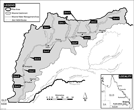
Column 1 | Column 2 | Column 3 |
Water management area | Name of water management area zone | Description of water management area zone |
Moonie water management area | Zone A | The Moonie River from Thallon Weir (AMTD 61.3km) downstream to the border between the State and New South Wales (AMTD 0.0km). |
Zone B | The Moonie River from AMTD 84.4km downstream to Thallon Weir (AMTD 61.3km). | |
Zone C | The Moonie River from the Carnarvon Highway crossing (AMTD 109.5km) downstream to AMTD 84.4km. | |
Zone D | The Moonie River from its junction with Teelba Creek (AMTD 193.9km) downstream to the Carnarvon Highway crossing (AMTD 109.5km). | |
Zone E | The Moonie River from AMTD 236.1km downstream to its junction with Teelba Creek (AMTD 193.9km). | |
Zone F | The Moonie River from the Bendee Road crossing (AMTD 290.5km) downstream to AMTD 236.1km. | |
Zone G | The Moonie River from its junction with Toombilla Creek (AMTD 349.4km) downstream to the Bendee Road crossing (AMTD 290.5km). | |
Zone H | The Moonie River from its upstream limit (AMTD 469.0km) downstream to its junction with Toombilla Creek (AMTD 349.4km). | |
Zone I | Teelba Creek from its upstream limit (AMTD 97.0km) downstream to its junction with the Moonie River (AMTD 0.0km). | |
Zone J | Wongle Wongle Creek from its upstream limit (AMTD 52.2km) downstream to its junction with the Moonie River (AMTD 0.0km). | |
Zone K | Parrie Moolan Creek from its upstream limit (AMTD 53.7km) downstream to its junction with the Moonie River (AMTD 0.0km). | |
Moonie water management area | Zone L | Hayes Creek from its upstream limit (AMTD 30.5km) downstream to its junction with the Moonie River (AMTD 0.0km). |
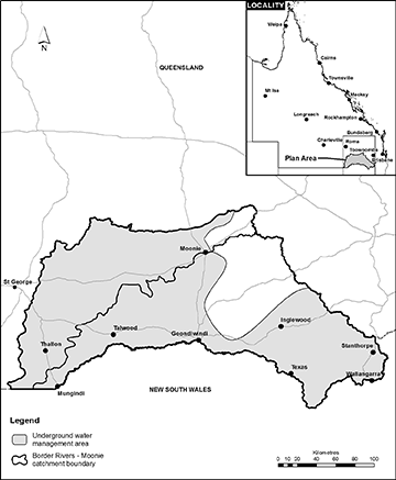
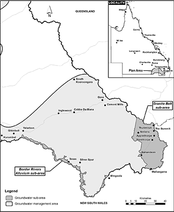
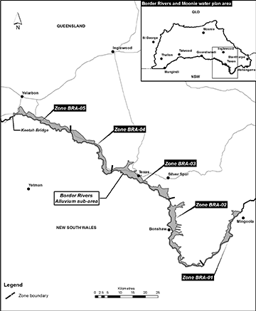
sections 28 and 29
(1)An environmental flow objective for surface water to which this plan applies is that the performance indicator mentioned in subsection (2) is not less than what the performance indicator was immediately before the commencement.(2)The performance indicator, for nodes A, H and I, is the mean annual flow at each node as a percentage of the pre-development flow for the node.(3)In this section—mean annual flow, at a node, means the total volume of flow of water at the node in the simulation period, divided by the number of years in the simulation period.pre-development flow, for a node, means the mean annual flow at the node simulated as if—(a)there were no dams or other water infrastructure in the plan area; and(b)no water had been taken under authorisations in the plan area.
2Days in no-flow periods to support waterhole persistence
(1)An environmental flow objective for surface water to which this plan applies is that the performance indicator mentioned in subsection (2) is not more than what the performance indicator was immediately before the commencement.(2)The performance indicator, for nodes A to K, is the total number of days in all no-flow periods at each node as a percentage of the total number of days in the simulation period.(3)In this section—no-flow period means a continuous period—(a)that is greater than—(i)for nodes A to I and K—1.5 years; or(ii)for node J—0.9 years; and(b)that is during the simulation period; and(c)during which daily water flows at the node are no more than 5ML.
3Days between fish migration flow events
(1)An environmental flow objective for surface water to which this plan applies is that the performance indicator mentioned in subsection (2) is not more than what the performance indicator was immediately before the commencement.(2)The performance indicator, for nodes A to K, is the total number of days in all intervening periods for each node as a percentage of the total number of days in the simulation period.(3)In this section—fish migration flow event, for a node, means a continuous period of 1 or more days, between 1 September of a year and 31 May of the next year—(a)starting when the daily water flow at the node is more than the fish movement threshold stated for the node in the following table; and(b)ending when the daily water flow at the node is less than the fish movement threshold stated for the node in the following table.
Node
Fish movement threshold (ML/day)
A
8,200
B
1,700
C
1,700
D
2,900
E
45,000
F
5,500
G
8,300
H
1,000
I
1,000
J
14,000
K
1,000
intervening period, for a node, means a period between fish migration flow events for the node that is—(a)4 years or more; and(b)during the simulation period.
4Days between floodplain inundation events
(1)An environmental flow objective for surface water to which this plan applies is that the performance indicator mentioned in subsection (2) is not more than what the performance indicator was immediately before the commencement.(2)The performance indicator, for nodes A to K, is the total number of days in all intervening periods for each node as a percentage of the total number of days in the simulation period.(3)In this section—floodplain inundation event, for a node, means a daily water flow at the node that is equal to or more than the flow rate at which the floodplain starts to fill, as stated for the node in the following table.
Node
Flow rate (ML/day)
A
27,000
B
9,000
C
5,600
D
16,000
E
110,000
F
165,000
G
28,000
H
1,000
I
6,100
J
14,000
K
7,500
intervening period, for a node, means a continuous period of more than 4 years and 7 months, during the simulation period, between floodplain inundation events for the node.
(1)An environmental flow objective for surface water to which this plan applies is that the performance indicator mentioned in subsection (2) is not less than what the performance indicator was immediately before the commencement.(2)The performance indicator, for nodes A to K, is the total number of days with a river-forming flow at each node as a percentage of the total number of days in the simulation period.(3)In this section—river-forming flow, at a node, means a daily water flow at the node that is more than the flow threshold stated for the node in the following table.
Node
Flow threshold (ML/day)
A
22,000
B
9,000
C
4,400
D
9,600
E
110,000
F
165,000
G
73,000
H
1,000
I
4,600
J
1,000
K
13,000
(1)An environmental flow objective for underground water to which this plan applies is that, at nodes L, M and N, the performance indicator mentioned in subsection (2) is at least the water level stated for each node in the following table.
Node
10th percentile water level (mAHD)
L
320.3
M
290.5
N
215.1
(2)The performance indicator, for nodes L, M and N, is the 10th percentile water level during the simulation period.
(1)An environmental flow objective for underground water to which this plan applies is that, at node M, the performance indicator mentioned in subsection (2) is at least 292.6mAHD.(2)The performance indicator, for node M, is the 90th percentile water level during the simulation period.
sections 30 and 68
Column 1 | Column 2 | Column 3 |
Water management area zone | Water source | Water allocation group |
Dumaresq zone | Dumaresq River | Class Dum1 |
Macintyre zone | Macintyre River | Class Mac1 |
Barwon zone | Macintyre River and Barwon River | Class Bar1 |
Lower Weir zone | Weir River | Class LW1 |
Class LW2 | ||
Upper Weir zone | Weir River | Class UW1A |
Class UW2A | ||
Class UW1B | ||
Class UW2B | ||
Class UW1C | ||
Class UW2C | ||
Yarrill Creek Wyaga Creek | Class Yar1 | |
Yambocully Creek | Class Yam1 | |
Class Yam2 | ||
Brigalow Creek | Class Bri1 | |
Class Bri2 | ||
Commoron Creek Murri Murri Creek | Class Com1 | |
Northern Weir zone | Weir River | Class NW1 |
Jib Creek | Class Jib1 | |
Cattle Creek | Class Cat1 | |
Waggaba Creek | Class Wag1 | |
Callandoon zone | Callandoon Creek | Class Cal1 |
Class Cal2 | ||
Macintyre Brook upstream zone | Macintyre Brook, Bracker Creek and their tributaries Overland flow water catchments for Macintyre Brook, Bracker Creek and their tributaries. | Class MB2 |
Macintyre Brook zone | Macintyre Brook | Class MB1 |
Mid Quart Pot Creek zone | Quart Pot Creek | Class MQPA |
Class MQPB | ||
Class MQPC | ||
Lower Quart Pot Creek zone | Quart Pot Creek | Class LQPA |
Class LQPB | ||
Class LQPC | ||
Lower Broadwater zone | The Broadwater | Class LBA |
Class LBB | ||
Class LBC | ||
Upper Severn River zone | Severn River | Class USA |
Class USB | ||
Class USC | ||
Mid Severn River zone 1 | Severn River | Class MS1A |
Class MS1B | ||
Class MS1C | ||
Mid Severn River zone 2 | Severn River | Class MS2A |
Class MS2B | ||
Class MS2C | ||
Lower Accommodation Creek zone | Accommodation Creek | Class LAA |
Class LAB | ||
Class LAC | ||
Lower Severn River zone 1 | Severn River | Class LS1A |
Class LS1B | ||
Class LS1C | ||
Lower Severn River zone 2 | Severn River and Dumaresq River | Class LS2A |
Class LS2B | ||
Class LS2C | ||
Upper Quart Pot Creek and tributaries zone | Quart Pot Creek and its tributaries | Class UQPA |
Class UQPB | ||
Class UQPC | ||
Mid Quart Pot tributaries zone | Quart Pot Creek tributaries | Class MQPTA |
Class MQPTB | ||
Class MQPTC | ||
Four Mile Creek and tributaries zone | Four Mile Creek and its tributaries | Class FMA |
Class FMB | ||
Class FMC | ||
Lower Quart Pot tributaries zone | Quart Pot Creek and its tributaries | Class LQPTA |
Class LQPTB | ||
Class LQPTC | ||
Upper Broadwater and tributaries zone | The Broadwater and its tributaries | Class UBA |
Class UBB | ||
Class UBC | ||
Cannon Creek and tributaries zone | Cannon Creek and its tributaries | Class CCA |
Class CCB | ||
Class CCC | ||
Lower Broadwater tributaries zone | The Broadwater tributaries | Class LBTA |
Class LBTB | ||
Class LBTC | ||
Bald Rock Creek and tributaries zone | Bald Rock Creek and its tributaries | Class BRA |
Class BRB | ||
Class BRC | ||
Upper Accommodation Creek and tributaries zone | Accommodation Creek and its tributaries | Class UAA |
Class UAB | ||
Class UAC | ||
Lower Accommodation tributaries zone | Accommodation Creek tributaries | Class LATA |
Class LATB | ||
Class LATC | ||
Upper Severn tributaries zone | Severn River tributaries | Class USTA |
Class USTB | ||
Class USTC | ||
Mid Severn tributaries zone | Severn River tributaries | Class MSTA |
Class MSTB | ||
Class MSTC | ||
Lower Severn tributaries zone | Severn River tributaries and Dumaresq River tributaries | Class LSTA |
Class LSTB | ||
Class LSTC | ||
Upper Pike Creek and tributaries zone | Pike Creek and its tributaries | Class UPA |
Class UPB | ||
Class UPC | ||
Fifteen Mile Creek and tributaries zone | Fifteen Mile Creek and its tributaries | Class 15MA |
Class 15MB | ||
Class 15MC | ||
Maryland Creek and tributaries zone | Maryland Creek and its tributaries | Class MCA |
Class MCB | ||
Class MCC | ||
Mid Pike Creek and tributaries zone | Pike Creek and its tributaries | Class MPA |
Class MPB | ||
Class MPC | ||
Zone A | Moonie River | Class A |
Zone B | Moonie River | Class B |
Zone C | Moonie River | Class C |
Zone D | Moonie River | Class D |
Zone E | Moonie River | Class E |
Zone F | Moonie River | Class F |
Zone G | Moonie River | Class G |
Zone H | Moonie River | Class H |
Zone I | Teelba Creek | Class I |
Zone J | Wongle Wongle Creek | Class J |
Zone K | Parrie Moolan Creek | Class K |
Zone L | Hayes Creek | Class L |
sections 31, 79 and 87
Column 1 | Column 2 | Column 3 | Column 4 |
Water allocation group | Available water ratio | Annual announcement volume probability | Purpose |
BRM01 | 1.00 | 100% | urban |
BRM02 | 0.53 | 50% | any |
Column 1 | Column 2 |
Water management area | Average annual volume (ML) |
Stanthorpe water management area | 4,500 |
Moonie water management area | 100 |
Column 1 | Column 2 | Column 3 |
Catchment | Underground water unit | Annual volume (ML) |
Border Rivers | Sediments above the Great Artesian Basin | 6,200 |
Border Rivers Fractured Rock | 387 | |
Moonie | Sediments above the Great Artesian Basin | 4,800 |
Border Rivers and Moonie | Queensland Murray-Darling Basin deep | 500 |
1Talwood town weir
2Bungunya town weir
3the excavated tanks that are part of Bungunya town water supply
4the existing dam on Lode Creek, on lot 303 on B348
5the existing dam on Black Swamp Creek, on lot 3 on SP160760
6the existing weir on Thirteen Mile Creek, on lot 24 on BNT1553
7The Soak on lot 1 on RP79060
8Glen Niven Dam
9the existing weir on Back Creek, on lot 2 on RP160929
10the existing weir on Sugarloaf Creek, on lot 8 on RP21506 and lot 413 on BNT1724
11the 3 existing dams on Spring Creek, on lot 219 on BNT1678
12the existing weir on Doctors Creek, on lot 134 on SP136686
13Thallon town weir
sections 50, definition licence to interfere and 54
Column 1 | Column 2 | Column 3 |
Licence to interfere with the flow of water | Existing authorisation | Volumetric limit (ML) |
03667T | 36678T | 30 |
04720T | 02174T | 7 |
04988T | 04991T | 3 |
07523T | 17827T | 14 |
10054T | 17878T | 100 |
10102T | 10101T | 1 |
14918T | 407799 | 14 |
16408T | 104034 | 120 |
16526T | 19221WT | 25 |
17350T | 17349T | 5 |
18190WT | 17892T | 88 |
18678WT | ||
25678T | 25677T | 6 |
25897T | 08355T | 2 |
30126T | 30125T | 1 |
30142T | 30214T | 6 |
33079T | 15372T | 21 |
33080T | 7 | |
33486T | 400153 | 10 |
37624T | ||
33967T | 33966T | 1 |
34118T | 44128T | 21 |
34182T | 18627T | 37 |
25893T | ||
34306T | 34305T | 56 |
34543T | 34542T | 4 |
45940T | ||
34552T | 102568 | 3 |
567888 | 20 | |
34582T | 1 | |
34843T | 28702T | 3 |
34919T | 34918T | 3 |
35150T | 35651T | 19 |
36908T | 184556 | 64 |
37619T | 33092WT | 10 |
37623T | 17191T | 6 |
37755T | 37754T | 28 |
38497T | 38499T | 16 |
38594T | 18510T | 73 |
25949T | ||
38722T | 172798 | 22 |
39315T | 35506T | 24 |
54713T | 16 | |
35537T | 8 | |
39321T | 37484T | 129 |
39960T | 39959T | 1 |
39962T | 29447T | 16 |
40063T | 54896T | 41 |
40439T | 603761 | 23 |
54808T | ||
41563T | 41562T | 3 |
42853T | 42852T | 24 |
18088T | 5 | |
37954T | 16 | |
44022T | 44021T | 3 |
44026T | 608453 | 38 |
44106T | 41987T | 110 |
46013T | 46011T and 46012T | 6 |
46026T | 606071 | 515 |
46027T | ||
50612T | 50611T | 2 |
50649T | 27714T | 33 |
50651T | 50650T | 3 |
50654T | 50653T | 1 |
50713T | 50712T | 1 |
50716T | 50715T | 17 |
50718T | 50717T | 9 |
50735T | 37251T | 21 |
37435T | 50 | |
50705T | 13 | |
50639T | 21 | |
37531T | 21 | |
50750T | 50749T | 1 |
50783T | 50782T | 15 |
54702T | 54701T | 60 |
54718T | 35437T | 4 |
54722T | 15148T | 3 |
54729T | 50771T | 3 |
54750T | 27488T | 38 |
54754T | 54753T | 10 |
54759T | 54711T | 6 |
54760T | 608251 | 121 |
54767T | 54820T | 25 |
54795T | 54794T | 19 |
54802T | 54710T | 5 |
54811T | 50784T | 1 |
54843T | 609088 | 225 |
54857T | 39977T | 3 |
54862T | 39439T | 7 |
•604818
•606284
•606357
•606772
•607055
•607229
•607601
•607602
•608361
•609233
•610657
•614255
•614256
•615314
•615335
•616953
•616954
•617026
•617027
•617208
•617373
•617456
Column 1 | Column 2 |
Water allocation number | Detail or condition |
202 on AP7583 | Condition: water taken under the water allocation must not be stored unless the water is being stored in the notified storage works described under Overland Flow Works Notification Acknowledgement 187163, 187165, 187166, 187168 and 492543 and Works Reference 19883, 19884, 20627, 20628, 20632, 34473 and 34474 |
203 on AP7583 | Condition: water taken under the water allocation must not be stored unless the water is being stored in the notified storage works described under Overland Flow Works Notification Acknowledgement 408693 and 408695 and Works Reference 31571 and 31576 |
210 on AP7583 | Condition: water taken under the water allocation must not be stored unless the water is being stored in the notified storage works described under Overland Flow Works Notification Acknowledgement 406649, 406650, 406656, 406663, 406673 and 406681 and Works Reference 30197, 30204, 30206, 30216, 30237 and 30241 |
215 on AP7583 | Condition: water taken under the water allocation must not be stored unless the water is being stored in the notified storage works described under Overland Flow Works Notification Acknowledgement 400218, 400219, 400220, 400221, 400222, 400223, 400224, 400229, 400231 and 400244 and Works Reference 25023, 25025, 25034, 25041, 25047, 25058, 25064, 25093 and 25114 |
229 on AP7583 | Condition: water taken under the water allocation is also permitted to be taken from the Dumaresq water management area zone downstream of the Dumaresq River, AMTD 5km |
242 on AP7583 | Conditions: 1 water taken under the water allocation must not be stored unless the water is being stored in the notified storage works described under Overland Flow Works Notification Acknowledgement 187939, 400001, 400003, 400004 and 400006 and Works Reference 21454, 24673, 24674, 24675, 24676, 24677, 24680 and 24682 2 water taken under the water allocation is also permitted to be taken from the Dumaresq water management area zone downstream of the Dumaresq River, AMTD 5km |
244 on AP7583 | Condition: water taken under the water allocation is also permitted to be taken from the Dumaresq water management area zone downstream of the Dumaresq River, AMTD 5km |
245 on AP7583 | Condition: water taken under the water allocation is also permitted to be taken from the Dumaresq water management area zone downstream of the Dumaresq River, AMTD 5km |
246 on AP7583 | Condition: water taken under the water allocation is also permitted to be taken from the Dumaresq water management area zone downstream of the Dumaresq River, AMTD 5km |
257 on AP7583 | Condition: water taken under the water allocation is also permitted to be taken from the Dumaresq water management area zone downstream of the Dumaresq River, AMTD 5km |
274 on AP7583 | Condition: water taken under the water allocation is also permitted to be taken from the Dumaresq water management area zone downstream of the Dumaresq River, AMTD 5km |
372 on AP7583 | Water allocation group: class UW1A |
373 on AP7583 | Water allocation group: class UW2A |
432 on AP7583 | Condition: water taken under the water allocation must not be stored unless the water is being stored in the notified storage works described under Overland Flow Works Notification Acknowledgement 406960 and Works Reference 30407 |
433 on AP7583 | Condition: water taken under the water allocation must not be stored unless the water is being stored in the notified storage works described under Overland Flow Works Notification Acknowledgement 406960 and Works Reference 30407 |
438 on AP7583 | Conditions: 1 water taken under the water allocation must not be stored unless the water is being stored in the notified storage works described under Overland Flow Works Notification Acknowledgement 183824, 183831, 183832 and 403679 and Works Reference 17563, 17572, 17573 and 28156 2 taking of water under the water allocation must not interfere with the distribution of water by the Callandoon Water Supply Board |
439 on AP7583 | Conditions: 1 water taken under the water allocation must not be stored unless the water is being stored in the notified storage works described under Overland Flow Works Notification Acknowledgement 183824, 183831, 183832 and 403679 and Works Reference 17563, 17572, 17573 and 28156 2 taking of water under the water allocation must not interfere with the distribution of water by the Callandoon Water Supply Board |
576 on AP7583 | Water management area zone: Mid Severn River zone 2 |
577 on AP7583 | Water management area zone: Mid Severn River zone 1 |
578 on AP7583 | Water management area zone: Mid Severn River zone 1 |
579 on AP7583 | Water management area zone: Mid Severn River zone 1 |
580 on AP7583 | Water management area zone: Mid Severn River zone 1 |
581 on AP7583 | Water management area zone: Mid Severn River zone 1 |
582 on AP7583 | Water management area zone: Mid Severn River zone 1 |
583 on AP7583 | Water management area zone: Mid Severn River zone 1 |
584 on AP7583 | Water management area zone: Upper Severn River zone |
585 on AP7583 | Water management area zone: Upper Severn River zone |
586 on AP7583 | Water management area zone: Upper Severn River zone |
589 on AP7583 | Water management area zone: Upper Severn River zone |
590 on AP7583 | Water management area zone: Upper Severn River zone |
591 on AP7583 | Water management area zone: Upper Severn River zone |
592 on AP7583 | Water management area zone: Upper Severn River zone |
593 on AP7583 | Water management area zone: Upper Severn River zone |
594 on AP7583 | Water management area zone: Upper Severn River zone |
595 on AP7583 | Water management area zone: Upper Severn River zone |
596 on AP7583 | Water management area zone: Upper Severn River zone |
599 on AP7583 | Water management area zone: Upper Severn River zone |
600 on AP7583 | Water management area zone: Upper Severn River zone |
601 on AP7583 | Water management area zone: Upper Severn River zone |
602 on AP7583 | Water management area zone: Upper Severn River zone |
603 on AP7583 | Water management area zone: Upper Severn River zone |
604 on AP7583 | Water management area zone: Mid Severn tributaries zone |
605 on AP7583 | Water management area zone: Mid Pike Creek and tributaries zone |
606 on AP7583 | Water management area zone: Fifteen Mile Creek and tributaries zone |
607 on AP7583 | Water management area zone: Fifteen Mile Creek and tributaries zone |
608 on AP7583 | Water management area zone: Lower Accommodation Creek zone |
609 on AP7583 | Water management area zone: Lower Accommodation Creek zone |
610 on AP7583 | Water management area zone: Lower Accommodation Creek zone |
611 on AP7583 | Water management area zone: Lower Accommodation Creek zone |
612 on AP7583 | Water management area zone: Lower Accommodation Creek zone |
613 on AP7583 | Water management area zone: Lower Accommodation Creek zone |
615 on AP7583 | Water management area zone: Lower Accommodation Creek zone |
616 on AP7583 | Water management area zone: Lower Accommodation Creek zone |
617 on AP7583 | Water management area zone: Lower Accommodation Creek zone |
618 on AP7583 | Water management area zone: Lower Accommodation Creek zone |
619 on AP7583 | Water management area zone: Lower Accommodation Creek zone |
620 on AP7583 | Water management area zone: Lower Accommodation Creek zone |
621 on AP7583 | Water management area zone: Lower Accommodation Creek zone |
622 on AP7583 | Water management area zone: Lower Accommodation Creek zone |
623 on AP7583 | Water management area zone: Upper Accommodation Creek and tributaries zone |
624 on AP7583 | Water management area zone: Upper Accommodation Creek and tributaries zone |
625 on AP7583 | Water management area zone: Lower Accommodation Creek zone |
626 on AP7583 | Water management area zone: Bald Rock Creek and tributaries zone |
627 on AP7583 | Water management area zone: Bald Rock Creek and tributaries zone |
628 on AP7583 | Water management area zone: Bald Rock Creek and tributaries zone |
629 on AP7583 | Water management area zone: Mid Severn tributaries zone |
630 on AP7583 | Water management area zone: Mid Severn tributaries zone |
631 on AP7583 | Water management area zone: Upper Severn tributaries zone |
632 on AP7583 | Water management area zone: Upper Severn tributaries zone |
633 on AP7583 | Water management area zone: Upper Severn tributaries zone |
634 on AP7583 | Water management area zone: Upper Severn tributaries zone |
635 on AP7583 | Water management area zone: Lower Broadwater zone |
637 on AP7583 | Water management area zone: Lower Broadwater zone |
638 on AP7583 | Water management area zone: Lower Broadwater zone |
639 on AP7583 | Water management area zone: Lower Broadwater zone |
640 on AP7583 | Water management area zone: Lower Broadwater zone |
641 on AP7583 | Water management area zone: Upper Broadwater and tributaries zone |
642 on AP7583 | Water management area zone: Upper Broadwater and tributaries zone |
643 on AP7583 | Water management area zone: Upper Broadwater and tributaries zone |
644 on AP7583 | Water management area zone: Upper Broadwater and tributaries zone |
645 on AP7583 | Water management area zone: Upper Broadwater and tributaries zone |
646 on AP7583 | Water management area zone: Upper Broadwater and tributaries zone |
647 on AP7583 | Water management area zone: Lower Broadwater tributaries zone |
648 on AP7583 | Water management area zone: Lower Broadwater tributaries zone |
649 on AP7583 | Water management area zone: Lower Broadwater tributaries zone |
650 on AP7583 | Water management area zone: Cannon Creek and tributaries zone |
651 on AP7583 | Water management area zone: Cannon Creek and tributaries zone |
652 on AP7583 | Water management area zone: Cannon Creek and tributaries zone |
653 on AP7583 | Water management area zone: Cannon Creek and tributaries zone |
654 on AP7583 | Water management area zone: Cannon Creek and tributaries zone |
656 on AP7583 | Water management area zone: Lower Quart Pot tributaries zone |
657 on AP7583 | Water management area zone: Four Mile Creek and tributaries zone |
658 on AP7583 | Water management area zone: Four Mile Creek and tributaries zone |
659 on AP7583 | Water management area zone: Four Mile Creek and tributaries zone |
660 on AP7583 | Water management area zone: Four Mile Creek and tributaries zone |
661 on AP7583 | Water management area zone: Four Mile Creek and tributaries zone |
662 on AP7583 | Water management area zone: Four Mile Creek and tributaries zone |
663 on AP7583 | Water management area zone: Four Mile Creek and tributaries zone |
664 on AP7583 | Water management area zone: Four Mile Creek and tributaries zone |
665 on AP7583 | Water management area zone: Four Mile Creek and tributaries zone |
666 on AP7583 | Water management area zone: Four Mile Creek and tributaries zone |
667 on AP7583 | Water management area zone: Four Mile Creek and tributaries zone |
668 on AP7583 | Water management area zone: Upper Quart Pot Creek and tributaries zone |
669 on AP7583 | Water management area zone: Upper Severn tributaries zone |
670 on AP7583 | Water management area zone: Upper Severn tributaries zone |
671 on AP7583 | Water management area zone: Lower Quart Pot Creek zone |
672 on AP7583 | Water management area zone: Lower Quart Pot Creek zone |
673 on AP7583 | Water management area zone: Lower Quart Pot Creek zone |
674 on AP7583 | Water management area zone: Lower Quart Pot Creek zone |
679 on AP7583 | Water management area zone: Mid Quart Pot Creek zone |
771 on AP7583 | Water management area zone: Lower Severn River zone 1 |
5057 on AP7583 | Condition: no conditions |
5170 on AP7583 | Water management area zone: Lower Broadwater zone |
5171 on AP7583 | Water management area zone: Lower Broadwater zone |
5196 on AP7583 | Water management area zone: Lower Accommodation Creek zone |
5197 on AP7583 | Water management area zone: Lower Accommodation Creek zone |
5204 on AP7583 | Condition: Water taken under the water allocation is also permitted to be taken from the Dumaresq water management area zone downstream of the Dumaresq River, AMTD 5km |
5205 on AP7583 | Condition: Water taken under the water allocation is also permitted to be taken from the Dumaresq water management area zone downstream of the Dumaresq River, AMTD 5km |
Column 1 | Column 2 |
Water allocation number | Detail or condition |
16 on AP13210 | Location of take: the Moonie River AMTD 151.1km to AMTD 155.3km |
31 on AP13210 | Condition: water may be taken when both— (a) the passing flow at the point of take is at least 129.6ML a day; and (b) the passing flow in the Moonie River at the junction with Hayes Creek is at least 172.8ML a day |
5004 on AP13210 | Condition: water may be taken when both— (a) the passing flow at the point of take is at least 43.2ML a day; and (b) the passing flow in the Moonie River at the junction with Hayes Creek is at least 172.8ML a day |
adopted middle thread distance means the distance in kilometres, measured along the middle of a watercourse, from a specific point in the watercourse to the watercourse’s mouth, the watercourse’s junction with the main watercourse or the border between the State and New South Wales.
AMTD means adopted middle thread distance.
ancillary water licence, for part 10, division 3, subdivision 2, see section 51(1)(d).
annual announcement volume probability, for a water allocation group, means the percentage of years, in a 100-year period, in which the total volume of water authorised to be taken, based on simulated demand, by the holders of all water allocations in the group is at least the total of the nominal volumes for all water allocations in the group.
authorisation means—
(a)a water allocation, water licence, water permit, seasonal water assignment notice or other authority to take water given under the Act or the repealed Act, other than a water permit for stock purposes or domestic purposes; or
(b)a water licence, resource operations licence or distribution operations licence to interfere with water given under the Act or the repealed Act; or
(c)an authority to take water given under another Act.
available water ratio, for a water allocation group, means the ratio of the average annual volume of water available for all water allocations in the group, to the total volumetric limit of all water allocations in the group.
average annual volume, of water, means the volume of the water expressed as a long-term modelled average over the simulation period for the water.
average volume means—
(a)for surface water—the total volume of surface water simulated, using the eWater Source computer program, to have been taken during the simulation period for surface water under all authorisations in the plan area included in the computer program, divided by the number of years in the simulation period; or
(b)for underground water—(i)the total volume of underground water simulated, using the MODFLOW computer program, to have been taken during the simulation period for underground water under all authorisations in the plan area included in the computer program, divided by the number of years in the simulation period; or(ii)the estimated volume divided by 100.
Border Rivers Alluvium (deep) decision support tool means a simulation tool used by the department to work out the annual announcement volume probability for a water allocation group when the holders of the water allocations in the group take water from the Border Rivers Alluvium (deep).
The Border Rivers Alluvium (deep) is an underground water sub-unit.
certified report means a report that—
(a)is verified and signed by a registered professional engineer under the Professional Engineers Act 2002; and
(b)for a certified report about works used, or capable of being used, to take overland flow water, describes—(i)the nature and location of the works; and(ii)how the works operate; and(iii)the ability of the works to take the water.
converted water allocation—
(a)for part 10, division 3, subdivision 2 and part 11, division 1, subdivision 2, see section 72(1); or
(b)for part 11, division 2, subdivision 2, see section 82(2).
daily water flow, at a node, means the volume of water that flows past the node in a day.
decision, for part 7, see section 34.
development permit, for an existing authorisation, means a development permit for works for taking water under the authorisation.
estimated volume means the total volume of underground water estimated by the chief executive—
(a)to have been taken, during any continuous 100-year period, under all authorisations in the plan area, other than authorisations mentioned in definition average volume, paragraph (b)(i) or water licences to which water sharing rules do not apply; and
(b)having regard to the following matters as at the commencement—(i)the volumetric limits applying to the authorisations;(ii)the water sharing rules for the authorisations;(iii)the conditions imposed on the authorisations.
eWater Source computer program means the eWater Source computer program used by the department to simulate daily stream flows, flow management, storages, releases, in-stream infrastructure, water diversions, water demands and other hydrological events in the plan area.
existing authorisation, in relation to a converted water allocation, means the water licence or water permit from which the water allocation was converted.
existing overland flow works means overland flow works used, or capable of being used, to take overland flow water to which this plan applies, other than for stock purposes or domestic purposes, if—
(a)the works are located in the Border Rivers catchment and were in existence on 20 September 2000; or
(b)the works are located in the Moonie catchment and were in existence on 9 June 2001; or
(c)for works located in the Border Rivers catchment that were started, but not finished, before 20 September 2000, or works located in the Moonie catchment that were started, but not finished, before 9 June 2001—the construction of the works was completed by—(i)if a moratorium notice stated the works must be completed by a day (the completion day), and a variation of the moratorium notice to extend the completion day was granted—the day stated in the notice of decision given for the variation under section 27(5)(b) of the Act, as in force immediately before 6 December 2016; or(ii)otherwise—30 November 2001; or
(d)for works used, or capable of being used, to take water declared to be overland flow water under section 7—(i)the construction of the works was completed before 6 July 2016; or(ii)otherwise—(A)the construction of the works was physically started before 6 July 2016 and was completed before 31 December 2016; and(B)the chief executive was, before 17 August 2016, given a notice for the works under item 5(c) of the moratorium notice, published on 6 July 2016, called ‘Moratorium notice Water Act 2000 Granite Belt underground water area’; or
(e)the works replace, or are a reconfiguration of, works mentioned in paragraph (a), (b), (c) or (d) if the replacement or reconfiguration of the works did not increase the average annual volume of overland flow water to which this plan applies capable of being taken by the works.
flow threshold means a requirement about flow rate, the water level of a flow or flow duration.
impounded water, for part 10, division 3, subdivision 2, see section 51(1)(a).
intergovernmental agreement means the agreement called ‘New South Wales–Queensland Border Rivers intergovernmental agreement 2008’, signed by the Premier of the State on 16 February 2009.
IQQM computer program simulation means the department’s Integrated Quantity and Quality Model computer program simulation, for the period July 1890 to June 2000, that was used to establish the sharing of water between the State and New South Wales under the intergovernmental agreement.
licence to interfere, for part 10, division 3, subdivision 2, see section 50.
MODFLOW computer program means the MODFLOW computer program used by the department to simulate the flow of underground water, water extractions, water demands, operational management and other hydrological events in the plan area.
moratorium notice means a moratorium notice published under section 26 of the Act, as in force immediately before 6 December 2016.
node see section 17(1).
nominal entitlement see the Water Regulation 2016, section 28(1).
notified existing overland flow works means existing overland flow works for which notice was given to the chief executive under—
(a)for works located in the Border Rivers catchment—the repealed Water Plan (Border Rivers) 2003, section 34(2)(b); or
(b)for works located in the Moonie catchment—the repealed Water Plan (Moonie) 2003, section 34(2)(b).
overland flow water catchment, for a watercourse, means a part of the plan area from which overland flow water will flow into the watercourse unless the water is taken before it reaches the watercourse.
overland flow works means—
(a)works used to store overland flow water, including, for example, a sump, drain, embankment, channel or pump; or
(b)works that can be used to connect 2 or more works mentioned in paragraph (a).
performance ratio, for a group of water allocations, means the average annual volume of water that may be taken by holders of all water allocations in the group in the simulation period expressed as a percentage of the total of the nominal volume for all water allocations in the group.
relevant operating arrangements, for existing overland flow works, means the arrangements under which the works were operated, that were in place immediately before—
(a)if the works are located in the Border Rivers catchment—20 September 2000; or
(b)if the works are located in the Moonie catchment—9 June 2001; or
(c)for works located in the Border Rivers catchment that were started, but not finished, before 20 September 2000, or works located in the Moonie catchment that were started, but not finished, before 9 June 2001—(i)if a moratorium notice stated the works must be completed by a day (the completion day), and a variation of the moratorium notice to extend the completion day was granted—the day stated in the notice of decision given for the variation under section 27(5)(b) of the Act, as in force immediately before 6 December 2016; or(ii)otherwise—30 November 2001; or
(d)for works used, or capable of being used, to take water declared to be overland flow water under section 7—(i)if the construction of the works was completed before 6 July 2016—that date; or(ii)if the construction of the works was physically started, but not completed, before 6 July 2016—31 December 2016.
relevant version of the Basin Plan, in relation to a provision of this plan, means the Basin Plan 2012 (Cwlth) as in force 2 years before the provision was given to the Minister under the Water Act 2007 (Cwlth), section 63(3)(c).
The Basin Plan 2012 (Cwlth) is made under the Water Act 2007 (Cwlth).
replacement water bore see the Water Regulation 2016, schedule 19.
simulation period means—
(a)for surface water to which this plan applies—the period from 1 July 1895 to 30 June 2014; or
(b)for underground water to which this plan applies—the period from 1 July 1916 to 39 June 2015.
Stanthorpe allocation, for part 11, division 1, subdivision 2, see section 70.
surface water see section 4.
sustainable diversion limits means the long-term average sustainable diversion limits under the relevant version of the Basin Plan.
underground water management area see section 12.
underground water sub-area see section 13(2).
underground water sub-unit see section 14(2).
underground water unit see section 14(1).
underground water zone see section 15(2).
unsupplemented surface water means surface water to which this plan applies that is not supplemented water within the meaning of the Water Regulation 2016, schedule 19.
Upper Weir allocation, for part 11, division 1, subdivision 2, see section 70.
variation, of a moratorium notice, means the variation of the moratorium notice under section 27 of the Act as in force immediately before 6 December 2016.
volumetric limit, for a water licence, means the maximum volume of water, in megalitres, that may be taken under the licence during a water year.
water management area zone see section 11(2).
water supply scheme zone see section 9(2).