


This regulation may be cited as the Fisheries Regulation 2008.
This regulation commences on 1 April 2008.
div hdg amd 2015 SL No. 12 s 5
3Regulation to be read with East Coast Trawl Plan
For taking particular fish in, or possessing or using particular fish taken in, the east coast trawl fishery area, this regulation must be read together with the East Coast Trawl Plan.See the East Coast Trawl Plan, section 6(1) and (2).s 3 amd 2010 SL No. 35 s 5 sch 1; 2011 SL No. 236 s 2 sch
sub 2015 SL No. 12 s 6
The dictionary in schedule 11 defines particular words used in this regulation.
In this division—species includes another taxonomic grouping.
6Scientific names for species of fish
(1)The scientific name for a species of fish mentioned in schedule 5, column 1 is the scientific name stated opposite the species of fish in schedule 5, column 2.(2)The scientific name for a species of fish mentioned in schedule 6, column 1 is the scientific name stated opposite the species of fish in schedule 6, column 2.(3)Without limiting subsection (1) or (2), the scientific name for a species of fish mentioned in this regulation or a management plan follows the scientific name for the species of the fish stated in a document mentioned in schedule 7 (a prescribed reference document).s 6 amd 2008 SL No. 156 s 3
7Alternative scientific names in prescribed reference documents
(1)Subsection (2) applies if, for a species of fish mentioned in this regulation or a management plan, there are alternative scientific names mentioned in more than 1 prescribed reference document under schedule 7.(2)The scientific name for the species follows the scientific name mentioned in the prescribed reference document with the lowest item number under schedule 7.(3)This section does not limit section 6.(4)In this section—alternative, to a scientific name, includes a variation of the name.s 7 amd 2010 SL No. 164 s 27
8Inconsistency between prescribed reference and scheduled names
(1)This section applies if—(a)in a document, other than a prescribed reference document, a species of fish is referred to by the scientific name for the species stated in a prescribed reference document (the prescribed reference name); and(b)the prescribed reference name is not consistent with the scientific name for the species stated in schedule 5 or 6 (the scheduled name).(2)The reference to the prescribed reference name may, if the context permits, be taken to be a reference to the scheduled name.
9References to regulated waters by name or description
A reference to particular regulated waters by name or description is a reference to the regulated waters with that name or description under schedule 1.
10Regulated period for prohibited or restricted activities in regulated waters
(1)This section applies if a regulated waters declaration states a particular period (a regulated period) in which an activity is prohibited or restricted in particular regulated waters.(2)The activity is prohibited or restricted in the waters under the declaration only in the regulated period.
11Activity prohibited or restricted at all times if no regulated period stated
(1)This section applies if—(a)an activity is prohibited or restricted in particular regulated waters under a regulated waters declaration; and(b)neither this regulation nor a management plan provides for a particular regulated period in which the activity is prohibited or restricted in the waters.(2)To remove any doubt, it is declared that the activity is prohibited or restricted in the waters at all times.
12References to taking a particular quantity of fish
For a fisheries declaration, a person takes a particular quantity of fish only if, at any given time, the person possesses that quantity of fish that the person has taken.
13References to an authority includes its conditions
A reference to an authority includes a reference to its conditions.
14References to activities carried out under an authority
A person carries out an activity under an authority only if—(a)the authority, or a provision of this regulation or a management plan about that type of authority, authorises the person to carry out the activity; and(b)the person carries out the activity in accordance with that authorisation.See also section 208 (Authorisations subject to regulation, management plans and authorities).
(1)Generally, a commercial fisher is anyone who holds a commercial fisher licence.(2)However, in a fishery provision about a commercial fishery in chapters 7 to 11, a reference to a commercial fisher is a reference to a commercial fisher acting under the commercial fishing boat licence on which is written a fishery symbol for the fishery.s 15 amd 2016 SL No. 193 s 3
15AWhat is a commercial fishery
(1)Generally, a commercial fishery is a fishery provided for under chapters 7 to 11 or a management plan.(2)A reference to a commercial fishery includes a reference to the authorisations and conditions stated in a fishery provision about the fishery.(3)A reference to doing a thing in a commercial fishery includes a reference to doing the thing under the authorisations and conditions stated in a fishery provision about the fishery.s 15A ins 2008 SL No. 448 s 4
amd 2010 SL No. 164 s 28
16References to the licence in a fishery provision
In a fishery provision about a commercial fishery, a reference to the licence is a reference to a licence on which is written a fishery symbol for the fishery.
17References to latitudes and longitudes
(1)Subject to subsection (2), the latitudes and longitudes used to describe the boundary of an area are worked out using GDA 94.(2)The latitudes and longitudes used to describe the boundary of an area shown on a fish habitat area plan mentioned in schedule 3 are worked out using AGD 84.(3)In this section—AGD 84 means the Australian Geodetic Datum 1984, commonly called ‘AGD 84’, defined in the technical report by Allman, JS and Veenstra, C titled ‘Geodetic Model of Australia 1982’, Technical Report 33, published in 1984 by the Commonwealth Department of Resources and Energy, Division of National Mapping.The report may be inspected, during office hours on business days, at the southern regional office of the department in which the Survey and Mapping Infrastructure Act 2003 is administered. On the notification day that office was at the Landcentre, corner of Vulture and Main Streets, Woolloongabba.GDA 94 means the Geocentric Datum of Australia 1994, commonly called ‘GDA 94’, notified in the Commonwealth Government Gazette No. GN 35 on 6 September 1995, at page 3369.s 17 amd 2010 SL No. 164 s 29
18References to boundaries, lines, shores and other points
Unless otherwise provided, the following apply—(a)a boundary or line along a shore follows high water mark;(b)a boundary or line along a shore intersected by a waterway crosses the waterway by the shortest line between its banks;(c)other boundaries and lines run from point to point in a straight line;(d)a reference to a shore is a reference to the shore at high water mark;(e)a reference to a point or to the tip of an island or other geographical feature, is a reference to the point or tip on the shore at high water mark.
Unless otherwise provided, a reference to a waterway is a reference to all of the following—(a)the waterway upstream of the shortest line between its banks at their junction, at low water, with the body of water into which the waterway finally flows;(b)the foreshores of the waterway.
20References to banks of waterways
Unless otherwise provided, a reference to a bank of a waterway is a reference to the bank at its junction, at high water, with the body of water into which it finally flows.
21References to aids to navigation
A reference to a beacon, buoy, lead, light or marine mark is a reference to an aid to navigation under the Transport Operations (Marine Safety) Act 1994, section 104.
22References to distances between nets
A reference to a distance between nets is a reference to—(a)for nets in a waterway—the distance between the nets measured along the centre line of the waterway; and(b)for nets on a foreshore—the distance between the nets measured along the shore.
23References to drops and number of meshes
(1)A reference to a net’s drop is a reference to the distance between the top and the bottom of the net when its meshes are taut.(2)A reference to a number of meshes in a net’s drop is a reference to the number of rows of mesh between the top and bottom of the net.
24References to periods of days or months
(1)This section applies if a provision of this regulation or a management plan states a period that—(a)starts on a day or in a month (the first mentioned day or month); and(b)ends on a day or in a month (the second mentioned day or month).(2)The period is taken to start at the beginning of the first mentioned day or month and end at the end of the second mentioned day or month.A stated period from 1 November to 1 February starts immediately after midnight at the beginning of 1 November and ends immediately before midnight at the end of 1 February.
(1)This section applies if a provision states a period that starts at a time (the first mentioned time) and ends at another time (the second mentioned time).(2)The period is taken to start at the first mentioned time and end at the second mentioned time whether the second mentioned time is on the same, or a different, day, week, month or year.•A stated period from midday on 1 November to midday on 1 February is a period of 3 months starting at midday on 1 November and ending at midday on 1 February.•A stated period from 4p.m. to 4a.m. is a period of 12 hours starting at 4p.m. on a particular day and ending at 4a.m. on the next day.•A stated period from 3p.m. to 5a.m. from 1 July to 31 October consists of each period of time within the stated days starting at 3p.m. on a particular day and ending at 5a.m. on the next day. The first period of time starts at 3p.m. on 1 July and the last period of time ends at 5a.m. on 31 October.
(1)This chapter provides for particular regulated waters declarations under sections 37(5) and 42 of the Act.The East Coast Trawl Plan also provides for particular regulated waters declarations.(2)Particular waters are—(a)declared to be regulated waters under part 2; and(b)regulated in the way stated under parts 3 to 12.(3)Part 13 provides generally for exceptions to regulated waters declarations under this chapter or a management plan.
27Particular waters declared as regulated waters
(1)Each of the waters described in schedule 1, column 2—(a)is declared to be regulated waters, subject to section 28; and(b)has the name set out opposite it in column 1 of the schedule.(2)The waters described in schedule 1, part 1 are named by reference to particular fish, the taking or possession of which is regulated in the waters.(3)The waters described in schedule 1, part 2 are—(a)named by reference to their location; and(b)listed in approximate order of their location going from south to north.1To help users of this regulation, indicative plans of particular regulated waters are published on the department’s website.2The indicative plans are not applied, adopted or incorporated by this regulation or any management plan.s 27 amd 2018 SL No. 179 s 3 sch 1
28Particular regulated waters shown on fisheries regulated waters plans
(1)Subject to section 29, if a plan number for a fisheries regulated waters plan is stated in schedule 1, column 2, the waters shown on the plan as regulated waters are declared to be regulated waters.Each fisheries regulated waters plan is identified by the prefix ‘FRW’ followed by the plan number. For example, ‘FRW-303’.(2)Fisheries regulated waters plans are held by the chief executive and copies of the plans are—(a)available for inspection, free of charge, during office hours on business days at the department's head office; and(b)published on the department’s website.s 28 amd 2018 SL No. 179 s 3 sch 1
29Boundaries of regulated waters on fisheries regulated waters plans
(1)If a fisheries regulated waters plan shows that particular waters (excluded waters) are excluded from the regulated waters shown on the plan, the excluded waters are not regulated waters.(2)Subject to subsection (3), a line in relation to a boundary of regulated waters on a fisheries regulated waters plan shows what forms the boundary of the regulated waters.(3)If a regulated waters plan shows a boundary of regulated waters by reference to a geographical feature or fixed structure—(a)the boundary of the regulated waters is decided by reference to the feature or structure; and(b)to the extent the boundary is decided by reference to the feature or structure, a line in relation to the boundary shown on the plan is only indicative of the current position of the boundary.Regulated waters are shown on a fisheries regulated waters plan by reference to a shore line. Rough weather alters the location of parts of the shore line. The boundary of the regulated waters is decided by reference to the shore line as altered, despite any inconsistency with the location of the shore line as shown on the plan.(4)If a boundary shown on a fisheries regulated waters plan has a gap in it, the boundary continues in a straight line across the gap to the nearest point of the boundary on the other side of the gap.
Each of parts 4 to 12A provide for the persons (each a regulated person) to whom particular regulated waters declarations under the relevant part apply.s 30 amd 2015 SL No. 125 s 4
31Activities prohibited or otherwise regulated
Particular provisions (each a regulating provision) under parts 4 to 12A provide for the activities that are prohibited or restricted in particular regulated waters under the regulating provision.For each entry for regulated waters described in schedule 1, column 2, the regulating provisions under which activities in the regulated waters are prohibited or otherwise regulated, are stated opposite the entry in schedule 1, column 3.s 31 amd 2015 SL No. 125 s 4
Any person is a regulated person.
sdiv hdg ins 2011 SL No. 224 s 3
This subdivision applies to the following regulated waters—•Mission Bay•South Mitchell River•Torres Strait near Hammond Island.s 33 sub 2008 SL No. 448 s 5; 2011 SL No. 224 s 4
A regulated person must not in the regulated waters—(a)take any fish; or(b)possess a fish taken in contravention of paragraph (a).
sdiv hdg ins 2011 SL No. 224 s 5
34ARegulated waters for sdiv 2
This subdivision applies to the following regulated waters—•Coombabah Lake and Coombabah Creek•Swan Bay•Wolf Rock (grey nurse shark protection area)•Tinana Creek Barrage•Mary River Barrage•Burnett River Barrage•Kolan River Barrage•Fitzroy River Barrage•Keppel Bay (fishing)•Hook Island (fishing)•Yanks Jetty at Orpheus Island•Centenary Lakes, Cairns•Barron River (fishing)•Bizant River, Princess Charlotte Bay.s 34A ins 2011 SL No. 224 s 5
(1)A regulated person must not in the regulated waters—(a)take any fish; or(b)possess a fish taken in contravention of paragraph (a).See also section 218A.(2)However, a person may take a juvenile eel in the following regulated waters if the person takes the eel under a licence on which is written the fishery symbol ‘JE’—•Mary River Barrage•Burnett River Barrage•Kolan River Barrage•Fitzroy River Barrage.s 34B ins 2011 SL No. 224 s 5
amd 2013 SL No. 270 s 3
This division applies to the following regulated waters—•Flat Rock (grey nurse shark protection area)•Cherub’s Cave (grey nurse shark protection area)•Henderson Rock (grey nurse shark protection area).s 35 amd 2011 SL No. 106 s 4
36Taking fish generally prohibited
A regulated person must not in the regulated waters—(a)take any fish; or(b)possess a fish taken in contravention of paragraph (a).
sdiv hdg amd 2008 SL No. 156 s 4
This subdivision applies despite section 36.
38Taking fish by hand or scoop net
A person may take a fish in the regulated waters if the person takes the fish—(a)under a licence on which is written the fishery symbol ‘A1’ or ‘A2’; and(b)by hand or using a scoop net or seine net; and(c)from 6a.m. to 6p.m. on a particular day.
(1)A person may take a spanner crab in the regulated waters if the person takes the crab—(a)under a licence on which is written the fishery symbol ‘C2’; and(b)from 6a.m. to 6p.m. on a particular day.(2)A recreational fisher may take a spanner crab in the regulated waters if the fisher—(a)does not use fishing apparatus, other than a prescribed dilly, for taking the crab; and(b)uses no more than 4 prescribed dillies to take the crab.(3)In this section—prescribed dilly means a dilly that has—(a)an area within its frame of no more than 1m2; and(b)a net drop below its frame of no more than 10cm; and(c)a net made up of square or rectangular meshes with a mesh size of at least 25mm; and(d)the following attached to it—(i)a tag on which is written the full name and address of the owner of the dilly;(ii)a light coloured float that is at least 15cm in all its dimensions and on which the owner’s name is also written.
s 40 amd 2012 SL No. 252 s 6 sch
om 2016 SL No. 193 s 4
Any person is a regulated person.
42Prohibited activities and regulated period
(1)A regulated person must not—(a)take Australian bass in tidal waters during the regulated period; or(b)possess Australian bass taken in contravention of paragraph (a).(2)For subsection (1)(a), the regulated period is from 1 June to 31 August.s 42 amd 2014 SL No. 69 s 4
div hdg sub 2011 SL No. 236 s 3
sdiv hdg ins 2011 SL No. 236 s 3
This subdivision applies to the waters other than the Gulf of Carpentaria waters.s 43 sub 2011 SL No. 236 s 3
44Prohibited activities and regulated period
(1)A regulated person must not in the regulated waters—(a)take barramundi in the regulated period; or(b)possess barramundi taken in contravention of paragraph (a).(2)For subsection (1)(a), the regulated period is from midday on 1 November to midday on 1 February.s 44 amd 2008 SL No. 314 s 16
sub 2011 SL No. 236 s 3
sdiv hdg ins 2011 SL No. 236 s 3
44ARegulated waters for sdiv 2
This subdivision applies to the Gulf of Carpentaria waters.s 44A ins 2011 SL No. 236 s 3
44BProhibited activities and regulated periods
(1)A regulated person must not in the regulated waters—(a)take barramundi in the regulated taking period; or(b)possess barramundi taken in contravention of paragraph (a).(2)For subsection (1)(a), the regulated taking period is from midday on 7 October to midday on 1 February.(3)Also, a regulated person must not in the regulated waters possess barramundi on a boat in the regulated possession period, whether or not the fish have been taken in the waters.(4)For subsection (3), the regulated possession period is from midday on 17 October to midday on 1 February.s 44B ins 2011 SL No. 236 s 3
sdiv hdg ins 2011 SL No. 236 s 3
45Recreational fishing in prescribed barramundi waterway
(1)This section applies despite sections 44 and 44B.(2)A recreational fisher may—(a)take no more than 1 barramundi in a prescribed barramundi waterway within the regulated waters under subdivision 1 or 2; or(b)possess a barramundi taken under paragraph (a).(3)However, subsection (2) applies only if the fisher does not possess the barramundi while taking fish in the regulated waters, other than a prescribed barramundi waterway.s 45 sub 2011 SL No. 236 s 3
div hdg ins 2010 SL No. 354 s 3
om 2011 SL No. 140 s 4
s 45A ins 2010 SL No. 354 s 3
om 2011 SL No. 140 s 4
s 45B ins 2010 SL No. 354 s 3
om 2011 SL No. 140 s 4
This division applies to the Coral reef fin fish regulated waters.
47Prohibited activities and regulated periods
(1)A regulated person must not in the regulated waters—(a)take a regulated coral reef fin fish in a regulated period; or(b)possess a regulated coral reef fin fish in a regulated period, whether or not the fish have been taken in the waters.(2)For subsection (1), each of the following periods is a regulated period—(a)from 6 October 2018 to 10 October 2018;(b)from 5 November 2018 to 9 November 2018;(c)from 25 October 2019 to 29 October 2019;(d)from 24 November 2019 to 28 November 2019;(e)from 14 October 2020 to 18 October 2020;(f)from 12 November 2020 to 16 November 2020;(g)from 3 October 2021 to 7 October 2021;(h)from 2 November 2021 to 6 November 2021;(i)from 22 October 2022 to 26 October 2022;(j)from 21 November 2022 to 25 November 2022;(k)from 12 October 2023 to 16 October 2023;(l)from 10 November 2023 to 14 November 2023.s 47 amd 2008 SL No. 384 s 4; 2009 SL No. 213 s 19; 2014 SL No. 69 s 5; 2018 SL No. 149 s 3
sdiv hdg amd 2008 SL No. 156 s 5
This subdivision applies despite section 47.
A regulated person may, in the regulated waters, possess, on a boat, a regulated coral reef fin fish if—(a)the fish has not been taken in the waters in contravention of section 47(1)(a); and(b)either of the following apply—(i)the person is in possession of the fish for the purpose of consumption on the boat and the boat is not a commercial fishing boat and does not have a fishing line, spear or spear gun on board;(ii)the boat is being used for a charter fishing trip that has been conducted for an uninterrupted period of at least 24 hours.
(1)A regulated person may, in the regulated waters, possess, on a boat, a regulated coral reef fin fish if—(a)the fish has not been taken in the waters in contravention of section 47(1)(a); and(b)the fish—(i)has been taken under chapter 10A, part 3; and(ii)is on an authorised boat; and(c)either—(i)the boat is in an unloading area; or(ii)the boat is not in an unloading area but only in a permitted period.(2)In this section—authorised boat see section 591W.permitted period means—(a)a period other than a regulated period mentioned in section 47(2); or(b)the period from midnight at the beginning of the first day of a regulated period mentioned in section 47(2) to 6a.m. on the day.unloading area see section 591W.s 50 amd 2008 SL No. 384 s 5; 2009 SL No. 213 s 20; 2015 SL No. 12 s 7
This division applies to the following regulated waters—•Dumaresq River at Bonshaw Weir•Pike Creek at Glenlyon Dam•Barwon River at Mungindi Weir•Severn River at Queen Mine Waterhole•Quart Pot Creek at Storm King Dam•Balonne River at Beardmore Dam and Jack Taylor Weir•Macintyre River at Goondiwindi Weir•Macintyre Brook at Coolmunda Dam, Whetstone and Bendor weirs•Sandy Creek at Leslie Dam•Burnett Creek at Maroon Dam•Reynolds Creek at Moogerah Dam•Nerang River at Hinze Dam•Albert River at Luscombe Weir•Logan River at South Maclean and Cedar Grove weirs•Brisbane River at Old Mt Crosby Weir•Brisbane River at Mt Crosby Weir•Brisbane River at Wivenhoe Dam•Balonne River at Surat Weir•Condamine River at Chinchilla, Loudon, Lemon Tree, Yarramalong, Cecil Plains and Reilly’s weirs•Dogwood Creek at Gil Weir (formerly Miles Weir)•Stuart River at Gordonbrook Dam•Six Mile Creek at Lake MacDonald•Boyne River (Auburn River Basin) at Boondooma Dam•Dawson River at Glebe Weir•Dawson River at Gyranda Weir•Nogo River at Wuruma Dam•Dawson River at Theodore Weir•Burnett River at Paradise Dam, Claude Wharton, Ned Churchward and Kirar weirs•Three Moon Creek at Cania Dam•Dawson River at Moura Weir•Dawson River at Orange Creek Weir•Dawson River at Neville Hewitt Weir•Boyne River (Boyne River Basin) at Awoonga Dam•Fitzroy River at Eden Bann Weir•Thomson River at Fairmount Weir•Fitzroy River at Wattlebank Control Weir•Nogoa River at Fairbairn Dam•Pioneer River at the Marian, Mirani and Dumbleton weirs•Burdekin River at Clare Weir•North Pine River at North Pine Dam•Sideling Creek at Kurwongbah Dam•Teviot Brook at Wyaralong Dam•Yabba Creek at Borumba Dam.s 51 sub 2008 SL No. 448 s 6
amd 2011 SL No. 106 s 5; 2014 SL No. 69 s 6; 2014 SL No. 282 s 4; 2016 SL No. 193 s 5
A regulated person must not in the regulated waters—(a)take a freshwater fish; or(b)possess a freshwater fish taken in contravention of paragraph (a).
div 6 (ss 53–54) sub 2014 SL No. 282 s 5
This division applies to the regulated waters of the Murray–Darling drainage division, other than the following dams—•Beardmore Dam•Beehive Dam•Connolly Dam•Cooby Dam•Coolmunda Dam•Glenlyon Dam•Leslie Dam•Storm King Dam.div 6 (ss 53–54) sub 2014 SL No. 282 s 5
54Taking Murray cod generally prohibited
(1)A regulated person must not in the regulated waters—(a)take a Murray cod during the regulated period; or(b)possess a Murray cod taken in contravention of paragraph (a).(2)For subsection (1)(a), the regulated period is from 1 September to 30 November.div 6 (ss 53–54) sub 2014 SL No. 282 s 5
This division applies to the following regulated waters—•Wynnum (gastropod area)•Nudgee Beach•Bramble Bay•Deception Bay.s 55 amd 2009 SL No. 61 s 5
A regulated person must not in the regulated waters—(a)take a gastropod or bivalve mollusc; or(b)possess a gastropod or bivalve mollusc taken in contravention of paragraph (a).
57Prohibited activities and regulated period
(1)A regulated person must not in the Spanner crab regulated waters—(a)take a spanner crab in the regulated period; or(b)possess a spanner crab taken in contravention of paragraph (a).(2)For subsection (1)(a), the regulated period is from 1 November to 15 December.s 57 amd 2018 SL No. 149 s 4
58Prohibited activities and regulated periods
(1)A regulated person must not in the Saucer scallop regulated waters—(a)take a saucer scallop in the regulated taking period; or(b)possess a saucer scallop taken in contravention of paragraph (a); or(c)possess a saucer scallop in the regulated possession period.(2)For subsection (1)(a), the regulated taking period is from midday on 20 September to midday on 1 November.(3)For subsection (1)(c), the regulated possession period is from 6p.m. on 20 September to midday on 1 November.s 58 amd 2008 SL No. 384 s 6
58AAProhibited activities and regulated periods for particular regulated waters
(1)A regulated person must not in the Swain Reefs and Hydrographers Passage regulated waters—(a)take a saucer scallop in the regulated taking period; or(b)possess a saucer scallop taken in contravention of paragraph (a); or(c)possess a saucer scallop in the regulated possession period.(2)For subsection (1)(a), the regulated taking period is from midday on 1 November to midday on 3 January.(3)For subsection (1)(c), the regulated possession period is from 6p.m. on 1 November to midday on 3 January.s 58AA ins 2008 SL No. 431 s 15
div hdg ins 2008 SL No. 314 s 17
sub 2009 SL No. 61 s 6
58AProhibited activities and regulated period
(1)A regulated person must not in the Northern rocklobster regulated waters—(a)take tropical rocklobster in the regulated period; or(b)possess a tropical rocklobster taken in contravention of paragraph (a).(2)For this section the regulated period is from midnight on 1 October to midnight on 31 December.s 58A ins 2008 SL No. 314 s 17
amd 2009 SL No. 61 s 7; 2014 SL No. 69 s 7
div 9B (s 58B) ins 2014 SL No. 282 s 6
A regulated person must not in the Thompson River Catchment regulated waters—(a)take a fish of the genus Craterocephalus; or(b)possess a fish of the genus Craterocephalus taken in contravention of paragraph (a).div 9B (s 58B) ins 2014 SL No. 282 s 6
59Prohibited activities—black jewfish
A regulated person must not in the North Cape York regulated waters—(a)take a black jewfish; or(b)possess a black jewfish taken in contravention of paragraph (a).
s 60 om 2011 SL No. 224 s 6
61Prohibited activities—fish other than fin fish
A regulated person must not in the Fitzroy Island–High Island regulated waters—(a)take any fish other than a fin fish; or(b)possess a fish taken in contravention of paragraph (a).
62Prohibited activities—mud crab
A regulated person must not in the Eurimbula Creek regulated waters—(a)take a mud crab; or(b)possess a mud crab taken in contravention of paragraph (a).s 62 amd 2008 SL No. 448 s 7
63Prohibited activities—pearl oysters
A regulated person must not in the Darnley Island regulated waters—(a)take a pearl oyster; or(b)possess a pearl oyster taken in contravention of paragraph (a).
64Prohibited activities—worms of the class Polychaeta
A regulated person must not in the Wynnum (worm area) regulated waters—(a)take a worm belonging to the class Polychaeta; or(b)possess a worm taken in contravention of paragraph (a).
Any person is a regulated person.
A regulated person must not in the Obi Obi Creek regulated waters—(a)possess a fishing line; or(b)use a fishing line to take a fish; or(c)possess a fish taken in contravention of paragraph (b).
This division applies to the following regulated waters—•Burnett River (netting)•Water Park Creek.
A regulated person must not in the regulated waters—(a)possess a net; or(b)use a net to take a fish; or(c)possess a fish taken in contravention of paragraph (b).
This division applies to the following regulated waters—•waterways, lakes and lagoons within the limits of the State•Moreton Bay (whole)•Hervey Bay and Great Sandy Strait (shell dredging)•Hinchinbrook Channel (fishing apparatus area 1).
A regulated person must not in the regulated waters—(a)use a shell dredge to take a fish; or(b)possess a fish taken in contravention of paragraph (a).
A recreational fisher is a regulated person.
sdiv hdg sub 2009 SL No. 61 s 8
A regulated person must not in the Platypus Bay regulated waters—(a)take a great barracuda, pickhandle barracuda or spanish mackerel; or(b)possess a fish taken in contravention of paragraph (a).s 72 amd 2009 SL No. 61 s 9
73Prohibited activities and regulated period—Fraser Island (Indian Head–Waddy Point)
(1)A regulated person must not in the Fraser Island (Indian Head–Waddy Point) regulated waters—(a)take a fin fish in the regulated period; or(b)possess a fin fish taken in contravention of paragraph (a).(2)For subsection (1)(a), the regulated period is from midday on 1 August to midday on 30 September.
74Prohibited activities—Pine River (north of Weipa)
(1)A regulated person must not in the Pine River (north of Weipa) regulated waters—(a)take a fin fish; or(b)possess a fin fish taken in contravention of paragraph (a).(2)However, subsection (1) does not apply to taking a fin fish in, or possessing a fin fish taken in, the regulated waters if the fish is not intentionally or recklessly injured or damaged and is immediately put back.s 74 amd 2011 SL No. 224 s 7; 2011 SL No. 236 s 2 sch
sdiv hdg sub 2009 SL No. 61 s 10
75Prohibited activities and regulated period—Northern rocklobster regulated waters
(1)Without limiting subsection (2), a regulated person must not in the Northern rocklobster regulated waters—(a)take more than 3 tropical rocklobsters outside the regulated period; or(b)possess a tropical rocklobster taken in contravention of paragraph (a).(2)If, outside the regulated period, there is more than 1 regulated person on a boat in the waters, the person in control of the boat must ensure there are no more than 6 tropical rocklobsters on the boat.(3)For this section the regulated period is from midnight on 1 October to midnight on 31 December.s 75 amd 2008 SL No. 314 s 18; 2009 SL No. 61 s 11; 2014 SL No. 328 s 4
76Prohibited activities—Southern rocklobster regulated waters
(1)Without limiting subsection (2), a regulated person must not in the Southern rocklobster regulated waters—(a)take more than 5 tropical rocklobsters; or(b)possess a tropical rocklobster taken in contravention of paragraph (a).(2)If there is more than 1 regulated person on a boat in the waters, each regulated person must ensure there are no more than 10 tropical rocklobsters on the boat.s 76 amd 2009 SL No. 61 s 12
sdiv hdg ins 2011 SL No. 224 s 8
sub 2012 SL No. 252 s 6 sch
76AProhibited activities—Sea cucumber regulated waters
A regulated person must not in the Sea cucumber regulated waters—(a)take a sea cucumber; or(b)possess a sea cucumber taken in contravention of paragraph (a).s 76A ins 2011 SL No. 224 s 8
amd 2012 SL No. 252 s 6 sch
This subdivision applies to the following regulated waters—•Hervey Bay (recreational netting)•Rodds Harbour (recreational netting).s 77 amd 2011 SL No. 106 s 6
A regulated person must not in the regulated waters—(a)possess a net; or(b)use a net to take a fish; or(c)possess a fish taken in contravention of paragraph (b).
A regulated person must not in the Skyringville Creek regulated waters—(a)possess a net, other than a scoop net; or(b)use a net, other than a scoop net, to take a fish; or(c)possess a fish taken in contravention of paragraph (b).
This subdivision applies to the following regulated waters—•Tallebudgera Creek (spearing)•Southern Moreton Bay (including The Broadwater)•Pumicestone Strait (spearing)•Moreton Island (artificial reef area)•Jetties in, or south of, the Noosa River•Mooloolah River (spearing)•Maroochy River (spearing)•Noosa River (spearing)•North Sandy Strait (artificial reef area)•Hervey Bay (artificial reef area off Woodgate)•Bargara Beach•Great Keppel Island•North Keppel Island•Seaforth Island•Dunk Island•Brampton Island–Pelican Island–Carlisle Island•Lindeman Island•Long Island•Molle Island•West Molle Island•Hook Island (spearing)•Hayman Island•Main wharf at Port Denison, Bowen•Cape Edgecumbe•Jetties at Dungeness and Lucinda Point•Richards Island•Cooktown wharf and nearby pontoons.s 80 amd 2008 SL No. 156 s 2 sch; 2011 SL No. 106 s 7
A regulated person must not in the regulated waters—(a)possess a spear or spear gun; or(b)use a spear or spear gun to take fish; or(c)possess fish taken in contravention of paragraph (b).
Any person is a regulated person.
83Prohibited activities—Pumicestone Strait
A regulated person must not in the Pumicestone Strait (commercial fishing) regulated waters—(a)take any fish for trade or commerce; or(b)possess a fish taken in contravention of paragraph (a).
84Prohibited activities and regulated period—Fraser Island (Indian Head–Waddy Point)
(1)A regulated person must not in the Fraser Island (Indian Head–Waddy Point) regulated waters—(a)take any fish for trade or commerce in the regulated period; or(b)possess a fish taken in contravention of paragraph (a).(2)For subsection (1)(a), the regulated period is from midday 1 August to midday on 30 September.
85Prohibited activities—Platypus Bay
A regulated person must not in the Platypus Bay regulated waters—(a)take any of the following fish for trade or commerce—(i)catfish of the family Ariidae;(ii)cobia;(iii)giant queenfish;(iv)great barracuda;(v)spanish mackerel;(vi)pickhandle barracuda;(vii)yellowtail kingfish; or(b)possess a fish taken in contravention of paragraph (a).s 85 amd 2009 SL No. 61 s 13
Any person is a regulated person.
This division applies to the following regulated waters—•The Broadwater (southern part) and Nerang River•Gold Coast Seaway•The Broadwater (western part)•Currumbin Creek•Currumbin Beach•Tallebudgera Creek (netting)•Coombabah Creek, Oyster Lake and Saltwater Creek•Coomera River•Manly Boat Harbour•Wynnum and Manly•Brisbane River (netting)•Brisbane Airport floodway channel to the Pine River•Sandgate Pier•South Pine River and North Pine River•Currimundi Lake and Currimundi Creek near Caloundra•Mooloolah River (netting)•Maroochy River and ocean foreshores (netting)•South Maroochy River and the North Maroochy River•Weyba Creek•Noosa River and Noosa’s main beach•Lake Como, Kin Kin Creek, the upper Noosa River and Lake Cootharaba•Rainbow Beach•Snapper Creek near Tin Can Bay•Wide Bay Bar•Theodolite Creek•Hervey Bay (commercial netting)•Coonarr Creek•Round Hill Creek•Eurimbula Creek•Rodds Harbour (commercial netting)•Calliope River (upstream from Farmers Island)•Fitzroy River (town reach netting)•Cawarral Creek•Causeway Lake, Shoal Bay•Rocky Dam Creek•Louisa Creek•Pioneer River (upstream)•Constant Creek (upstream)•Reliance Creek, west of Eimeo•Seaforth Creek•Victor Creek•Proserpine River•Pioneer Bay•Bowen Harbour and Magazine Island•Merinda Creek•Groper Creek, Yellow Gin Creek and the Burdekin River•Burdekin River Anabranch•Plantation Creek and Seaforth Creek•Barramundi Creek•Haughton River and the Short Cut•Townsville Harbour and Cleveland Bay•Rollingstone Creek•Herbert River•Hinchinbrook Channel (fishing apparatus area 2)•Meunga Creek•Murray River•Johnstone River•Russell River, Mulgrave River and Mutchero Inlet•Trinity Inlet•Trinity Bay•Daintree River•Bloomfield River•Annan River•Endeavour River•Bizant River, North Kennedy River and Normanby River•Mission River, Embley River and Hey River•Pine River (north of Weipa)•Watson River•Kirke River•Chapman River•Chapman River to Moonkan Creek•Moonkan Creek•Mitchell River•Staaten River•Gilbert River•Bronco’s Creek•Norman River (downstream)•Norman River (upstream)•Bynoe River and Little Bynoe River•Flinders River and Armstrong Creek•Albert River•Nicholson River•Gin Arm Creek•Elizabeth River (Mornington Island)•Sandalwood Place River (Mornington Island).s 87 amd 2008 SL No. 156 s 2 sch; 2008 SL No. 314 s 19
sub 2008 SL No. 448 s 8 (amd 2009 SL No. 114 s 3)
amd 2011 SL No. 224 s 9; 2011 SL No. 236 s 2 sch
A regulated person must not in the regulated waters—(a)possess a net for taking fish for trade or commerce; or(b)use a net for taking a fish for trade or commerce; or(c)possess a fish taken in contravention of paragraph (b).
s 89 amd 2008 SL No. 448 s 9; 2013 SL No. 270 s 4
om 2015 SL No. 125 s 5
90Regulated waters and regulated periods for div 3
In the table below—(a)column 1 states the regulated waters to which this division applies; and(b)the regulated period for the regulated waters stated in column 1 is stated in column 2 opposite the entry for the regulated waters.
Column 1
Column 2
Regulated waters
Regulated periods
lakes and lagoons south of the northern bank of the Endeavour River and east of longitude 142º31'49" east
from 6p.m. on Friday to 6p.m. on Sunday
waterways south of Double Island Point
from 6p.m. on Friday to 6p.m. on Sunday
The Broadwater (central part)
the following regulated periods—
(a) from 1 August to 31 August;(b) from 1 September to 30 November, at the following times—• Monday to Thursday—from 6a.m. to 6p.m;• from 6a.m. on Friday to 6p.m. on Sunday;(c) from 1 December to the end of FebruaryTallebudgera Creek to Burleigh (netting)
from 1 September to 30 April
North Stradbroke Island (northern beaches)
from 20 September to 1 April
Dunwich
from 1 August to 30 April
Moreton Bay (including The Broadwater)
from 6p.m. on Friday to 6p.m. on Sunday
Caloundra (Kings Beach to Shelly Beach)
from 1 September to 31 March
Noosa River (ocean foreshore)
from 1 May to 31 August
Fraser Island (Tooloora Creek to Ngkala Rocks)
from midday 1 April to midday on 1 September
Fraser Island (Hook Point to northern tip)
from midday 1 September to midday on 1 April
Great Sandy Strait
from 1 February to 30 November—from 2p.m. Friday to 2p.m. Sunday; and
from 1 December to 31 January—from 6p.m. Friday to 6p.m. Sunday
Point Vernon to Cape Manifold
from 6p.m. on Friday to 6p.m. on Sunday
Wild Cattle Creek
from 1 September to 30 April
Tannum Sands
from 1 September to 30 April
Boyne River and part of South Trees Inlet
from 1 September to 30 April
Port of Gladstone and The Narrows
from 6p.m. on Friday to 6p.m. on Sunday
Fitzroy River mouth
from 6p.m. on Friday to 6p.m. on Sunday
St. Lawrence Creek to Endeavour River
from 6p.m. on Friday to 6p.m. on Sunday
Hinchinbrook Channel (all nets)
from 6p.m. on Friday to 6p.m. on Sunday
s 90 amd 2008 SL No. 314 s 20; 2008 SL No. 448 s 10
A regulated person must not in the regulated waters—(a)possess a net for taking fish for trade or commerce in the relevant regulated period for the waters; or(b)use a net for taking a fish for trade or commerce in the relevant regulated period for the waters; or(c)possess a fish taken in contravention of paragraph (b).
Part 10 Declarations about possessing or using particular nets for taking fish for trade or commerce
Any person is a regulated person.
93Prohibited activities—spanish mackerel regulated waters
A regulated person must not in the Spanish mackerel regulated waters—(a)use commercial fishing nets to take spanish mackerel for trade or commerce; or(b)possess a spanish mackerel taken in contravention of paragraph (a).
94Prohibited activities—Fraser Island (tailor) regulated waters
A regulated person must not in the Fraser Island (tailor) regulated waters—(a)use commercial fishing nets to take tailor for trade or commerce; or(b)possess tailor taken in contravention of paragraph (a).
This division applies to the regulated waters stated in column 1 of the table below section 96.
A regulated person must not in the regulated waters stated in column 1 of the table below—(a)possess a commercial fishing net of a type stated opposite the regulated waters in column 2 of the table; or(b)use a net referred to in paragraph (a) to take a fish for trade or commerce; or(c)possess a fish taken in contravention of paragraph (b).
Column 1
Column 2
Regulated waters
Prohibited commercial fishing nets
South of North Stradbroke Island
a net that is neither fixed nor hauled of a type mentioned in section 480 or a set mesh net of a type mentioned in section 483
Moreton Bay (area 1)
a net that is neither fixed nor hauled of a type mentioned in section 480 or a set mesh net of a type mentioned in section 483
Moreton Island to Double Island Point
a net that is neither fixed nor hauled of a type mentioned in section 480 or a set mesh net of a type mentioned in section 483
Fraser Island (rivers and creeks)
a general purpose mesh net, of a type, and used in a way, mentioned in section 482(1) or a set mesh net of a type, and used in a way, mentioned in section 499
Hervey Bay (scallop ranching area)
a trawl net
Pioneer River (downstream)
a commercial fishing net other than—
(a) a cast net; or(b) a mesh net used as a seine netO’Connell River
a commercial fishing net other than—
(a) a cast net; or(b) a mesh net used as a seine netQueens Bay
a set mesh net of a type mentioned in section 485 or 516 or a net that is neither fixed nor hauled of a type mentioned in section 480 or 514
s 96 amd 2008 SL No. 156 s 6; 2008 SL No. 448 s 11; 2011 SL No. 106 s 8; 2011 SL No. 224 s 10
This division applies to the following regulated waters—•Bundaberg–Gladstone–Rockhampton (regional waterways)•Middle Head to Norton Point•South Trees Inlet•Calliope River (near mouth)•Waters off Curtis Island•Cattle Point to Cardigan Point•Island Bluff to Charon Point•Little Cape Creek to Shag Creek•South Bluff to Coconut Point•Mackay (regional waterways)•Constant Creek (near mouth)•Burdekin–Townsville–Ingham (regional waterways)•Nobbies Inlet•Burdekin River Anabranch mouth•Sheep Station Creek to Barratta Creek•Victoria Creek•Gentle Annie Creek•Hinchinbrook Channel (set mesh nets)•Macushla Point to Forkey’s Creek (Hinchinbrook Island)•Innisfail (regional waterways)•Thompson Point to Flying Fish Point•Cairns and Port Douglas (regional waterways)•Barron River area (netting)•Mossman River area.s 97 sub 2008 SL No. 448 s 12
98Prohibited activities and regulated period
(1)A regulated person must not in the regulated waters—(a)possess a nearshore net or an offshore net in the regulated period; or(b)use a nearshore net or an offshore net to take a fish for trade or commerce in the regulated period; or(c)possess a fish taken in contravention of paragraph (b).(2)For subsection (1), the regulated period is from midday 1 November to midday 1 February.(3)In this section—nearshore net means a set mesh net that may under this regulation or a management plan, be used in nearshore waters to take fish.offshore net means a set mesh net that—(a)may, under this regulation or a management plan, be used in offshore waters to take fish; and(b)has a monofilament diameter of more than 1.06mm.s 98 amd 2008 SL No. 448 s 13
This division applies to the following regulated waters—•Port Musgrave and Wenlock River•Wellesley Islands Protected Wildlife Area.
A regulated person must not in the regulated waters—(a)possess a set mesh net for taking fin fish, other than regulated coral reef fin fish, for trade or commerce; or(b)use a set mesh net to take a fin fish, other than a regulated coral reef fin fish, for trade or commerce; or(c)possess a fish taken in contravention of paragraph (b).
101Exceptions for Wellesley Islands Protected Wildlife Area regulated waters
(1)This section applies despite section 100.(2)A person may use or possess a set mesh net to take a fin fish, other than a regulated coral reef fin fish, from the offshore waters in the Wellesley Islands Protected Wildlife Area regulated waters if—(a)the net is made from a continuous filament or strand of synthetic fibre that is joined, knitted or woven into meshes; and(b)the net is no longer than 400m and has a mesh size of at least 162.5mm but no more than 245mm; and(c)the line thickness of the net is no more than 1.04mm; and(d)the net’s drop is no more than 50 meshes; and(e)the water in which the net is being used is not shallower than the net’s drop; and(f)the person is within 100m of the net while the person is using it; and(g)the total length of all nets on the boat being used to take the fish is no more than 400m.(3)A person may use or possess a set mesh net to take fin fish, other than regulated coral reef fin fish, in nearshore waters within the regulated waters if—(a)the net is no longer than 100m and has a mesh size of at least 162.5mm but no more than 245mm; and(b)the net’s drop is no more than 33 meshes; and(c)the total length of all nets on the boat being used to take the fish is no more than 600m.s 101 amd 2008 SL No. 448 s 14; 2012 SL No. 252 s 7
102Regulated persons for pt 11
Any person is a regulated person.
103Prohibited activities—Hervey Bay–Tin Can Bay (greater dugong protection area) regulated waters
(1)A regulated person must not—(a)use a set mesh net in the Hervey Bay–Tin Can Bay (greater dugong protection area) regulated waters; or(b)use a net that is neither fixed nor hauled in offshore waters in the regulated waters.(2)Despite subsection (1), the person may use a set mesh net or a net that is neither fixed nor hauled in offshore waters in the regulated waters if the net—(a)is made of monofilament no more than 0.65mm in diameter; and(b)is no more than 33 meshes deep; and(c)is used by at least 2 persons, each of whom is on a boat floating on the water and within 100m of the net.(3)This section is subject to—(a)sections 104, 105 and 106; and(b)for a person taking fish in the regulated waters under a licence for a commercial net fishery—the authorisations and conditions of the licence stated in chapter 9.s 103 sub 2008 SL No. 448 s 15 (amd 2009 SL No. 114 s 4)
104Prohibited activities—Mary River–Burrum River (dugong protection area) waters
(1)This section applies to the following waters (the Mary River–Burrum River (dugong protection area) waters)—(a)waters within the following boundary—•from latitude 25º10'24'' south where it intersects the mainland shore near Burrum River to latitude 25º10'24'' south, longitude 152º39'06'' east•to latitude 25º13'24'' south, longitude 152º40'12'' east•along latitude 25º13'24'' south to where it intersects the mainland shore•along the mainland shore to latitude 25º10'24'' south;(b)waterways adjoining the waters mentioned in paragraph (a), other than waters of the Burrum River upstream of 152º35'50'' east;(c)waters of the Mary River downstream of longitude 152º54'24'' east.(2)A regulated person must not use a set mesh net in the Mary River–Burrum River (dugong protection area) waters.s 104 sub 2009 SL No. 114 s 20
amd 2010 SL No. 164 s 30
105Prohibited activities and regulated period—Hervey Bay (dugong protection area) waters
(1)This section applies to waters and adjoining waterways south of latitude 25º04'30'' south and west of longitude 152º40' east (the Hervey Bay (dugong protection area) waters).(2)A regulated person must not use a set mesh net or a net that is neither fixed nor hauled in the Hervey Bay (dugong protection area) waters in the regulated period.(3)For subsection (2), the regulated period is from 3p.m. to 5a.m. from 1 July to 31 October.s 105 sub 2009 SL No. 114 s 20
106Prohibited activities—Hervey Bay–Great Sandy Strait waterways (dugong protection area) waters
(1)This section applies to tidal waters of a river or creek between the north bank of Kauri Creek and latitude 25º01'01'' south where it intersects the mainland shore, other than—(a)waters of the Burrum River downstream of 152º35'50'' east; and(b)waters of the Mary River that are—(i)downstream of longitude 152º54'24'' east; or(ii)upstream of longitude 152º47'30'' east (the western tip of Brothers Islands).(2)The waters to which this section applies are the Hervey Bay–Great Sandy Strait waterways (dugong protection area) waters.(3)A regulated person must not use a set mesh net in the Hervey Bay–Great Sandy Strait waterways (dugong protection area) waters unless the net—(i)is no longer than 50m; and(ii)has a drop of no more than 50 meshes.(4)For a person taking fish in the regulated waters under a licence for a commercial net fishery, this section is subject to the authorisations and conditions of the licence stated in chapter 9.s 106 sub 2009 SL No. 114 s 20
amd 2010 SL No. 164 s 31
s 107 om 2009 SL No. 114 s 21
s 108 om 2009 SL No. 114 s 21
(1)A regulated person must not in the Port Clinton (greater dugong protection area) regulated waters—(a)use a mesh net with a mesh size of more than 115mm; or(b)fix more than 1 part of a mesh net if all of the net is in nearshore waters; or(c)fix any part of a mesh net if part of the net is in offshore waters; or(d)use a set mesh net; or(e)use a net that is neither fixed nor hauled.(2)Despite subsection (1), a regulated person may use up to 3 set mesh nets in the Port Clinton (dugong protection area 1) waters only if—(a)each net is no longer than 50m; and(b)each net has a mesh size of at least 150mm but no more than 215mm; and(c)each net has a drop of no more than 50 meshes; and(d)the nets are no more than 800m apart; and(e)any person using the nets is—(i)between the first and the last net; and(ii)no more than 800m from any of the nets.(3)In this section—Port Clinton (dugong protection area 1) waters means the waters of that name shown on fisheries regulated waters plan FRW-901.Section 28(2) provides for the availability of fisheries regulated waters plans.s 109 amd 2008 SL No. 156 s 7; 2008 SL No. 448 s 18 (amd 2009 SL No. 114 s 7)
A regulated person must not use or possess a net, other than a cast net, in the Shoalwater Bay (dugong protection area) regulated waters.
div hdg sub 2008 SL No. 448 s 19
s 110A ins 2008 SL No. 156 s 8
om 2008 SL No. 448 s 19
111Prohibited activities—Upstart Bay (greater dugong protection area) regulated waters
(1)A regulated person must not in the Upstart Bay (greater dugong protection area) regulated waters—(a)use a mesh net with a mesh size of more than 115mm; or(b)fix more than 1 part of a mesh net if all of the net is in nearshore waters; or(c)fix any part of a mesh net if part of the net is in offshore waters; or(d)use a set mesh net; or(e)use a net that is neither fixed nor hauled.(2)Despite subsection (1), a regulated person may—(a)use up to 3 set mesh nets in a river or creek in the regulated waters only if—(i)the nets are not set downstream of a line between the banks of the river or creek; and(ii)each net is no longer than 50m; and(iii)each net has a mesh size of at least 150mm but no more than 215mm; and(iv)each net has a drop of no more than 50 meshes; and(v)the nets are no more than 800m apart; and(vi)a person using the nets is—(A)between the first and the last net; and(B)no more than 800m from any of the nets; or(b)use up to 3 set mesh nets in the nearshore waters in the Upstart Bay (dugong protection area 1) waters only if—(i)each net is no longer than 200m; and(ii)each net being used is entirely within the nearshore waters; and(iii)each net has a mesh size of at least 100mm but no more than 215mm; and(iv)the distance between the first and last net is no more than 1km; and(v)the nets are no more than 800m apart; and(vi)a person using the nets is—(A)between the first and the last net; and(B)no more than 800m from any of the nets.(3)Subsection (4) applies to the waters within the following boundary—•from latitude 19º43'37" south where it intersects the mainland shore•east along latitude 19º43'37" south to 200m seaward from high water mark•south parallel to the mainland shore 200m seaward from high water mark to where it intersects latitude 19º48' south•west along latitude 19º48' south to the mainland shore at high water mark•along the mainland shore to 19º43'37" south.(4)Despite subsection (1)(d), a regulated person may use a set mesh net in nearshore waters in the regulated waters if all of the net is in the nearshore waters.s 111 sub 2008 SL No. 448 s 19 (amd 2009 SL No. 114 s 8)
s 112 sub 2008 SL No. 156 s 9
om 2008 SL No. 448 s 19
s 113 om 2008 SL No. 448 s 19
A regulated person must not in the Hinchinbrook Island (dugong protection area) regulated waters—(a)use a mesh net with a mesh size of more than 115mm; or(b)fix more than 1 part of a mesh net if all of the net is in nearshore waters; or(c)fix any part of a mesh net if part of the net is in offshore waters; or(d)use a set mesh net; or(e)use a net that is neither fixed nor hauled.s 114 sub 2008 SL No. 156 s 10; 2008 SL No. 448 s 20 (amd 2009 SL No. 114 s 9)
This division applies to the following regulated waters—•Ince Bay (dugong protection area)•Stewart Peninsula–Newry Islands–Ball Bay (dugong protection area)•Cleveland Bay–Magnetic Island (dugong protection area).
116Prohibited activities—using mesh nets generally
(1)A regulated person must not in the regulated waters—(a)use a mesh net with a mesh size of more than 115mm; or(b)fix more than 1 part of a mesh net if all of the net is in nearshore waters; or(c)fix any part of a mesh net if part of the net is in offshore waters; or(d)use a set mesh net; or(e)use a net that is neither fixed nor hauled.(2)This section is subject to section 116A.s 116 amd 2008 SL No. 156 s 11; 2008 SL No. 314 s 21
sub 2008 SL No. 448 s 21 (amd 2009 SL No. 114 s 10)
116AProhibited activities—using set mesh nets in rivers or creeks
A regulated person may use up to 3 set mesh nets in a river or creek in the regulated waters only if—(a)the nets are not set downstream of a line between the banks of the river or creek; and(b)each net is no longer than 50m; and(c)each net has a mesh size of at least 150mm but no more than 215mm; and(d)each net has a drop of no more than 50 meshes; and(e)any person using the nets is—(i)between the first and the last net; and(ii)no more than 800m from any of the nets.s 116A ins 2008 SL No. 448 s 21
117Regulated persons for pt 12
Any person is a regulated person.
This part applies to the following regulated waters—•Port of Gladstone–Rodds Bay (dugong protection area)•Clairview Bluff–Carmilla Creek (dugong protection area)•Llewellyn Bay (dugong protection area)•Ball Bay–Sand Bay (dugong protection area)•Repulse Bay (dugong protection area)•Edgecumbe Bay–Bowen (dugong protection area)•Bowling Green Bay (dugong protection area)•Lucinda to Allingham–Halifax Bay (dugong protection area).
119Prohibited activities—using mesh nets generally
A regulated person must not in the regulated waters—(a)use a mesh net, other than a set mesh net or a net that is neither fixed nor hauled, that has a mesh size of more than 115mm; or(b)fix more than 1 part of a mesh net unless the net is—(i)of a type mentioned in sections 120, 120A, 121 and 122; and(ii)used under the relevant section; or(c)use a net that is neither fixed nor hauled in nearshore waters; or(d)subject to section 120, use a set mesh net or a net that is neither fixed nor hauled in offshore waters within 2km of the high water mark.s 119 amd 2008 SL No. 156 s 2 sch
sub 2008 SL No. 448 s 22 (amd 2009 SL No. 114 s 11)
120Using mesh nets in offshore waters
A regulated person may in the regulated waters use a set mesh net or a net that is neither fixed nor hauled in offshore waters within 2km of the high water mark only if—(a)the net does not touch the seabed; and(b)the net has attached to it enough floats to ensure the floats remain on the surface of the water; and(c)the net is no longer than 600m; and(d)the net has a mesh size of at least 160mm but no more than 165mm; and(e)the commercial fisher using the net remains on a boat floating on the water and within 100m of the net while the net is being used.s 120 sub 2008 SL No. 448 s 22
120AUsing set mesh nets in nearshore waters
A regulated person may in the regulated waters use a set mesh net in nearshore waters only if—(a)each net is no longer than 200m; and(b)each net has a mesh size of at least 100mm but no more than 215mm; and(c)the entire net is in nearshore waters while it is being used; and(d)the distance between the first and last net is no more than 1km; and(e)the nets are no more than 800m apart; and(f)any person using the nets is—(i)between the first and the last net; and(ii)no more than 800m from any of the nets.s 120A ins 2008 SL No. 448 s 22
121Using set mesh nets on a headland
A regulated person may use up to 3 set mesh nets on a headland in the regulated waters only if—(a)each net is no longer than 50m; and(b)each net has a mesh size of at least 100mm but no more than 215mm; and(c)the distance between the first and last net is no more than 1km; and(d)the nets are no more than 800m apart; and(e)any person using the nets is—(i)between the first and the last net; and(ii)no more than 800m from any of the nets; and(f)one end of each net is anchored above the low water mark.s 121 amd 2008 SL No. 448 s 23
122Using set mesh nets in rivers or creeks
A regulated person may use up to 3 set mesh nets in a river or creek in the regulated waters only if—(a)each net is no longer than 120m; and(b)each net has a mesh size of at least 150mm but no more than 215mm; and(c)each net has a drop of no more than 50 meshes; and(d)the combined lengths of the nets is no more than 360m; and(e)the nets are no more than 800m apart; and(f)the distance between the first and last net is no more than 1n mile; and(g)any person using the nets is—(i)between the first and the last net; and(ii)no more than 800m from any of the nets.s 122 amd 2008 SL No. 448 s 24
Part 12A Declaration about commercial fishers possessing or using particular nets for taking fish for trade or commerce
pt hdg ins 2015 SL No. 125 s 6
div hdg ins 2015 SL No. 125 s 6
123Regulated persons for pt 12A
A commercial fisher is a regulated person.s 123 prev s 123 amd 2008 SL No. 156 s 2 sch
om 2008 SL No. 448 s 25
pres s 123 ins 2015 SL No. 125 s 6
div hdg ins 2015 SL No. 125 s 6
123ARegulated waters for div 2
This division applies to the following regulated waters—(a)Yeppoon–Keppel Bay–Fitzroy River–Capricorn Coast waters;(b)St Helens Beach–Cape Hillsborough–North of Mackay waters;(c)Trinity Bay–Cairns waters.s 123A ins 2015 SL No. 125 s 6
(1)A regulated person must not in the regulated waters—(a)possess a relevant net for taking fish for trade or commerce, unless the net is stowed and secured on a boat; or(b)use a relevant net for taking fish for trade or commerce.See section 88 under which parts of the regulated waters are subject to prohibitions on possession or use of any nets.(2)In this section—relevant net means a cast net, mesh net, seine net or set pocket net.s 123B ins 2015 SL No. 125 s 6
This part applies despite parts 3 to 12.
125Person may carry out prohibited activity under permit
(1)A person may carry out an activity in regulated waters that is prohibited under this chapter or a management plan if the person carries out the activity under a permit.(2)This section applies subject to part 12A.s 125 amd 2016 SL No. 193 s 6
126Possessing stowed and secured fishing apparatus
(1)This section applies if possessing fishing apparatus is prohibited in regulated waters under a provision of this chapter or a management plan, unless the provision provides otherwise.(2)A person may possess fishing apparatus, other than an otter trawl net, in the waters if the apparatus is stored inboard a boat.(3)A person may possess an otter trawl net in the waters if the net is stowed and secured on a boat.(4)For subsection (3), an otter trawl net is stowed and secured on a boat if—(a)during the daytime—(i)the net and any other fishing apparatus normally used with it are drawn up to the boat and are visible from an aircraft or another boat; and(ii)the net’s cod ends are open; and(iii)the net’s lazy lines are on the blocks; and(b)at night—(i)the boat is at anchor in an area marked as an anchorage or boat harbour on a navigational chart; or(ii)the net and other fishing apparatus are inboard the boat and are stored or suspended from a mast or boom.Examples of other fishing apparatus—
otter boards or ground chains or ropes for an otter trawl net
(1)Subsection (2) applies if, under a provision of this chapter or a management plan, possessing or using a trawl net is prohibited in regulated waters.(2)A person may possess or use a trawl net on a boat in the waters if—(a)the use or possession is only for testing the net or other fishing apparatus normally used with the net; and(b)the person in control of the boat has given the nearest Queensland Boating and Fisheries Patrol oral or written notice of the testing; and(c)the net’s cod ends are open; and(d)no fish are taken during the test.(3)The notice must—(a)be given at least 24 hours before the testing starts; and(b)state—(i)a square area, with boundaries no longer than 1n mile, where the testing is to happen; and(ii)when the testing is to start and end.
128Operation of ch 3 and sch 2
(1)This chapter and schedule 2 provide for regulated fish declarations under sections 37(2) and 42 of the Act.(2)Particular fish are declared to be regulated fish under part 2 and are regulated in the way stated under part 3 and schedule 2.(3)Particular fish are also declared to be regulated fish under part 4 and are regulated in the way stated under that part.(4)Part 5 regulates the number of fish that may be taken, and the form in which the fish may be possessed, by a recreational fisher on an extended licensed charter fishing trip.(5)Part 6 provides for ways of measuring the size, volume or weight of particular fish to decide if the fish are regulated fish.(6)Part 7 provides generally for exceptions to regulated fish declarations.
129Relationship with regulated waters declarations
(1)This section applies if an activity—(a)is not prohibited under a regulated fish declaration; and(b)would, if it were carried out in regulated waters, contravene a regulated waters declaration.(2)To remove any doubt, it is declared that the carrying out of the activity is still a contravention of the regulated waters declaration.
130Declaration of particular fish as regulated fish
(1)Fish stated in schedule 2, part 2, column 1 and part 3, column 1 are declared to be regulated fish.(2)Subsection (1) is subject to sections 131 to 138 and parts 5 and 7.
(1)This section applies if, for an entry for fish identified in schedule 2, part 2, column 1—(a)the symbol ‘F’ is stated in schedule 2, part 2, column 2; and(b)a form (the regulated form) of the fish is stated opposite the symbol in schedule 2, part 2, column 3.a fish that is cut, filleted or processed in a particular way(2)Only the identified fish in the regulated form are declared to be regulated fish.
132Fish regulated by gender or reproductive capacity
(1)This section applies if, for an entry for fish identified in schedule 2, part 2, column 1—(a)the symbol ‘G’ is stated in schedule 2, part 2, column 2; and(b)a gender (the regulated gender) or a description of the reproductive capacity of the fish (the regulated reproductive capacity) is stated opposite the symbol in schedule 2, part 2, column 3.Example of a description of the reproductive capacity of a fish—
an egg bearing slipper lobster(2)Only the identified fish of the regulated gender or regulated reproductive capacity are declared to be regulated fish.
133Fish regulated by number separately
(1)This section applies if, for an entry for fish identified in schedule 2, part 2, column 1—(a)the symbol ‘N’ is stated in schedule 2, part 2, column 2; and(b)a number (the regulated number) is stated opposite the symbol in schedule 2, part 2, column 3.(2)Only the identified fish in excess of the regulated number are declared to be regulated fish.
134Fish regulated by number separately and in combination
(1)This section applies if—(a)an entry in schedule 2, part 3, column 1 identifies particular fish separately and in combination; and(b)a number (also the regulated number) is stated for the entry in schedule 2, part 3, column 3.(2)The particular fish in excess of the regulated number are declared to be regulated fish.(3)Also, any fish of the combination in excess of the regulated number are declared to be regulated fish.
(1)This section applies if, for an entry for fish identified in schedule 2, part 2, column 1, the symbol ‘S’ is stated in schedule 2, part 2, column 2.(2)If a minimum size (the regulated minimum size) is stated opposite the symbol in schedule 2, part 2, column 3, only the identified fish that are smaller than the regulated minimum size are declared to be regulated fish.(3)If a maximum size (the regulated maximum size) is stated opposite the symbol in schedule 2, part 2, column 3, only the identified fish that are larger than the regulated maximum size are declared to be regulated fish.(4)For subsections (2) and (3), the size of a fish may be stated by reference to the size of a part of the fish, including, for example, if the fish is a crab, the size of its carapace.
(1)This section applies if, for an entry for fish identified in schedule 2, part 2, column 1—(a)the symbol ‘V’ is stated in schedule 2, part 2, column 2; and(b)a volume (the regulated volume) is stated opposite the symbol in schedule 2, part 2, column 3.(2)Only the identified fish in excess of the regulated volume are declared to be regulated fish.
(1)This section applies if, for an entry for fish identified in schedule 2, part 2, column 1—(a)the symbol ‘W’ is stated in schedule 2, part 2, column 2; and(b)a weight (the regulated weight) is stated opposite the symbol in schedule 2, part 2, column 3.(2)Only the identified fish in excess of the regulated weight are declared to be regulated fish.
138Declaration subject to condition
Despite sections 131 to 137, if the declaration of fish as regulated fish is subject to a condition, however expressed, stated in schedule 2, part 2, column 3 or part 3, column 3, the fish is declared to be regulated fish only if the condition is satisfied.Under schedule 2, part 2 a shark (other than a grey reef shark, whitetip reef shark, speartooth shark, white shark or sandtiger shark) is declared to be regulated fish on the condition, stated in column 3 of the schedule, that the shark’s tail and all of its fins are not secured to its body.s 138 amd 2011 SL No. 224 s 11
139Fish declared to be regulated fish in more than 1 way
Fish may be declared to be regulated fish in more than 1 way under this part.Under schedule 2, part 2 black jewfish taken by recreational fishers in the Gulf of Carpentaria waters are regulated by number and size.
140Meaning of activity involving regulated fish
An activity involving regulated fish means—
(a)taking, buying, selling, possessing or using the regulated fish; or(b)taking, buying, selling, possessing or using the regulated fish in a particular way.
141Particular activities involving regulated fish are prohibited activities
(1)Subject to subsections (2) and (3), for an entry for regulated fish identified in schedule 2, part 2, column 1 or part 3, column 1, an activity involving the regulated fish stated opposite the entry in schedule 2, part 2, column 4 or part 3, column 4 is a prohibited activity.(2)If the activity is subject to a condition, however expressed, the activity is a prohibited activity involving regulated fish only if the condition is satisfied.1Under schedule 2, part 2 a person is prohibited from taking jungle perch only if the relevant stated condition, namely that the person is in possession of a spotted flagtail, is satisfied.2Under schedule 2, part 2 a recreational fisher is prohibited from possessing a fillet of particular regulated coral reef fin fish only if the relevant stated conditions, namely that the fillet is not at least 40cm long and not all of the skin of the fillet is attached to it, are satisfied.(3)If the activity is taking or possessing the fish, or taking or possessing the fish for trade or commerce, the activity is not a prohibited activity if the taking or possessing is carried out under a contract entered into by the chief executive for the establishment or management of the shark control program.(4)For subsection (2), a prohibited activity involving regulated fish may be stated to apply only in a particular area.Under schedule 2, part 2, taking silver perch is stated to be a prohibited activity if the fish are taken from waters of the Paroo River Basin or Warrego River Basin, other than waters on privately owned land that are not part of a waterway.s 141 amd 2008 SL No. 448 s 26; 2009 SL No. 114 s 22
142Regulated person not to carry out prohibited activity involving regulated fish
(1)Subject to section 143, for an entry for regulated fish identified in schedule 2, part 2, column 1 or part 3, column 1, a person (a regulated person) stated opposite the entry in schedule 2, part 2, column 4 or part 3, column 4 must not carry out a prohibited activity involving the fish stated opposite the entry in schedule 2, part 2, column 4 or part 3, column 4.(2)In this section—person includes a member of a class of persons.
143Regulated fish declarations may apply differently
(1)For an entry for regulated fish identified in schedule 2, part 2, column 1 or part 3, column 1, regulated fish declarations may apply differently to a person or different persons by reference to different matters.Under schedule 2, part 2, a person is prohibited from taking a grey mackerel less than 60cm. Also, a recreational fisher is prohibited from taking more than 5 of the fish.(2)In this section—person includes a member of a class of persons.s 143 amd 2008 SL No. 448 s 27
144Total number of regulated coral reef fin fish
(1)Any regulated coral reef fin fish in excess of 20 are declared to be regulated fish.(2)A recreational fisher must not take more than 20 regulated coral reef fin fish.There is an exception to this regulated fish declaration under section 150 (Extended number for regulated coral reef fin fish).
145When other regulated fish declarations apply despite s 144
(1)This section applies if a recreational fisher takes regulated coral reef fin fish of only 1 species regulated by number under a regulated fish declaration in schedule 2.(2)This section also applies if—(a)a recreational fisher takes regulated coral reef fin fish of more than 1 species regulated by number under 1 or more regulated fish declarations in schedule 2; and(b)the total of the regulated numbers of the species is no more than 20.(3)The regulated fish declarations mentioned in subsection (1) and (2) apply despite section 144.A recreational fisher takes a combined total of 7 regulated coral trout of different species as allowed under a regulated fish declaration in schedule 2, part 3. Section 144 does not operate to allow the fisher to take more than 7 of the fish.
146When s 144 applies despite other regulated fish declarations
(1)This section applies if—(a)a recreational fisher takes regulated coral reef fin fish of more than 1 species regulated by number under regulated fish declarations in schedule 2; and(b)the total of the regulated numbers of the species would, apart from subsection (2), be more than 20.(2)Section 144 applies despite the regulated fish declarations mentioned in subsection (1).A recreational fisher takes 10 hussar and a combined total of 7 regulated coral trout as allowed under regulated fish declarations in schedule 2. The fisher would otherwise be able to take an additional 8 redthroat emperor under schedule 2 but section 144 operates to prevent the fisher from taking more than 3 redthroat emperor.s 146 amd 2009 SL No. 61 s 14
147Fillets counted as whole fish
For this division and section 150, a person possessing 2 whole or partial fillets of a regulated coral reef fin fish is taken to possess 1 whole regulated coral reef fin fish.See also section 184(7) of the Act which provides that if it is relevant to establish a person took fish, evidence that the person possessed the fish at any time is evidence that the person took the fish.
148Particular fish taken from regulated waters
(1)This section applies if—(a)a regulated person under chapter 2, parts 4 to 12, takes or possesses fish in regulated waters; and(b)the taking or possession of the fish in the regulated waters contravenes a regulated waters declaration under chapter 2, parts 4 to 12; and(c)the fish are outside the regulated waters.(2)The fish are declared to be regulated fish.(3)A person must not possess the fish.(4)If there is an inconsistency between subsection (3) and another regulated fish declaration, subsection (3) prevails to the extent of the inconsistency.
This part applies despite part 4, division 1 and schedule 2.
150Extended number for regulated coral reef fin fish
(1)Subsections (3) to (5) prescribe the number (the extended number) of regulated coral reef fin fish that may be—(a)taken, during an extended licensed charter fishing trip, by a recreational fisher who is on a boat and taking part in the trip; and(b)possessed by the fisher.(2)However, subsections (3) to (5) apply only if the trip is conducted for a continuous period of at least 72 hours.(3)Subject to subsections (4) and (5), the extended number of regulated coral reef fin fish of a particular species or a group of species is twice the regulated number of the fish for the species or group.(4)If the trip is conducted for a continuous period of more than 72 hours and less than 168 hours, the extended number of regulated coral reef fin fish of all species or groups of species is a total of 40 fish.(5)If the trip is conducted for a continuous period of more than 168 hours, the extended number of regulated coral reef fin fish of all species or groups of species is a total of 60 fish.See also section 147.
151Form of regulated coral reef fin fish for extended licensed charter fishing trip
(1)This section applies if a recreational fisher takes regulated coral reef fin fish under section 150.(2)The fisher may possess a fillet of the fish on the boat during the charter fishing trip but only if—(a)all the skin on the fillet remains attached to the fillet; and(b)the fillets of each species of fish taken are packaged separately; and(c)each package is labelled with the common name of the species of fish in the package.
152Extended number for other particular fin fish
(1)This section applies to a recreational fisher who is, or has been, on a boat and taking part in an extended licensed charter fishing trip.(2)The fisher may—(a)during the charter fishing trip, take up to twice the regulated number of a species of fish mentioned in schedule 6, part 4; and(b)possess the fish taken under paragraph (a).s 152 amd 2016 SL No. 75 s 129 sch 12
153Form of other particular fin fish for extended licensed charter fishing trip
(1)This section applies if a recreational fisher takes a fin fish, other than a regulated coral reef fin fish, on a boat, during an extended licensed charter fishing trip.(2)The fisher may possess the fish on the boat but only if the fisher ensures a square area of skin with sides of at least 3cm is left on the fish.
The size of a Balmain bug must be decided by measuring the widest part of its carapace.
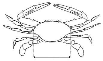
(1)The size of a blue swimmer crab must be decided by measuring the distance between—(a)the notch immediately forward of the base of the large lateral spine of the crab on one side of the crab; and(b)the notch immediately forward of the base of the large lateral spine of the crab on the other side of the crab.(2)The following figure is an example of the operation of subsection (1) in diagrammatic form—
The distance between the 2 vertical dotted lines is the distance to be measured to decide the size of a blue swimmer crab.
The size of a Moreton Bay bug must be decided by measuring the widest part of its carapace.s 156 amd 2009 SL No. 61 s 15
157Fin fish (general provisions)
(1)The size of a fin fish is decided by measuring, with the fish in the required position—(a)for a flathead, shark or ray—the distance along a straight horizontal line along the centre of the fish’s underside from the foremost point of the fish to the end of its tail; or(b)for a fin fish, other than a fish mentioned in paragraph (a)—the distance along a straight horizontal line (the measurement line) along the fish’s side from its mouth to—(i)the point on the measurement line where the fish’s tail ends; or(ii)if part of the tail extends further than the point on the measurement line where the fish’s tail ends—the point on the measurement line corresponding in length with the end of the longest part of the fish’s tail.(2)For subsection (1), the size of the fish must be measured without manipulating the fish, other than to the extent reasonably necessary to allow the fish to be measured as required under the subsection.(3)In this section—required position means—(a)for a fish mentioned in subsection (1)(a)—lying on its underside; or(b)for a fish mentioned in subsection (1)(b)—lying on its side with the dorsal fin facing outward and its mouth closed.(4)The following figure is an example of the operation of subsections (1)(b) and (3), definition required position, in diagrammatic form—s 157 amd 2008 SL No. 448 s 28
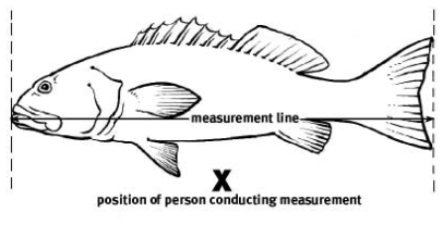
157AFin fish (interdorsal length for shark or ray)
(1)The interdorsal length for a shark or ray must be decided by measuring the distance along a straight line between—(a)the point where the posterior edge of the first dorsal fin is, or was, attached to the body; and(b)the point where the posterior edge of the second dorsal fin is, or was, attached to the body.(2)The following figure is an example of the operation of subsection (1) in diagrammatic form—
The distance between the 2 vertical dotted lines is the distance to be measured to decide the interdorsal length for a shark or ray.
s 157A ins 2008 SL No. 448 s 29
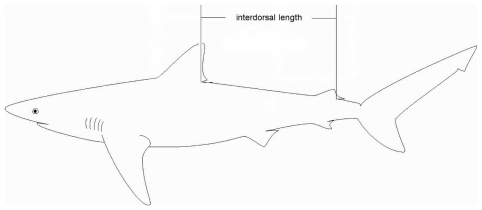
The size of a mud crab must be decided by measuring the widest part of its carapace.s 158 sub 2009 SL No. 213 s 21
The size of a painted crayfish must be decided by measuring, in a straight line—(a)if its carapace is not damaged or missing—from the anterior mid-dorsal margin to the posterior mid-dorsal margin of the cephalothorax; or(b)if its carapace is damaged or separated from its body—along the dorsal surface from the anterior margin of the first abdominal somite to the posterior margin of the sixth abdominal somite, when the tail is laid flat on a horizontal surface.
The size of a pearl oyster must be decided by measuring from the edge of its butt or hinge to the opposite edge of its shell, whether or not the shell is broken or chipped.
The size of a red champagne lobster must be decided by measuring, in a straight line, from the anterior mid-dorsal margin to the posterior mid-dorsal margin of the cephalothorax.s 160A ins 2011 SL No. 224 s 12
The size of a three-spotted crab must be decided by measuring the widest part of its carapace.s 161 amd 2009 SL No. 61 s 16
The size of a saucer scallop must be decided by measuring the widest part of its shell, whether or not the shell is broken or chipped.
(1)The size of a spanner crab must be decided by measuring the shortest distance between—(a)the tip of the spike at the middle of the front edge of its carapace; and(b)the mid point of the rear edge of its carapace.(2)If the carapace is damaged or separated from the crab’s body the size of the crab must be decided by measuring its sternite at the widest part of the front of its breastplate, located directly in front of the bases of the main claws.
The size of a trochus must be decided by measuring the widest part of the base of its shell.
165How total volume must be measured
(1)This section provides for how a total volume of fish must be measured.(2)The volume of fish that are in a container (contained fish) must be measured by reference to the volume of the container when it is empty.1An empty container with internal dimensions of 571mm x 381mm x 305mm, commonly called a ‘lug basket’, has a capacity of approximately 66L.2An empty container with internal dimensions of 605mm x 280mm x 90mm, commonly called a ‘prawn carton’, has a capacity of approximately 0.0153m3.(3)For subsection (2), a fish is not a contained fish if any part of it protrudes above the top of the container.(4)The volume of any of the fish that are not contained fish (uncontained fish) must be measured by—(a)placing them in a container or containers so that no part of any of the fish protrudes above the top of the container or containers; and(b)measuring the volume of each container when it is empty; and(c)referring to the volume of the container or containers.(5)The total volume of fish is worked out by adding together the volume of all of the contained and uncontained fish.
(1)This section provides for how the weight of a green snail must be decided.(2)The weight of a green snail is its empty shell weight.
167Threshold percentage of saucer scallops
(1)This section provides for working out the threshold percentage of undersized scallops that are included in a quantity of saucer scallops that have been taken or possessed by a person.(2)The threshold percentage must be worked out by—(a)counting all of the undersized scallops and expressing the number of undersized scallops as a percentage of the total number of saucer scallops taken or possessed; or(b)statistical sampling and testing as follows—(i)collecting information (the sample data) about the total number of saucer scallops taken or possessed by taking a random sample of the scallops and counting the number of undersized saucer scallops;(ii)using the sample data and a statistical method to estimate, based on a probability of 95%, the percentage of the total number of undersized scallops taken or possessed.(3)For subsection (2)(b), a saucer scallop that is not whole, including, for example, a saucer scallop that is cut, dismembered, shelled or shucked, must not be counted or included in a sample.(4)In this section—undersized scallops means saucer scallops that are less than the regulated minimum size provided for saucer scallops under a regulated fish declaration.
This part applies despite parts 2 and 3, part 4, division 1, part 5 and schedule 2.
169Person may carry out prohibited activity under permit
A person may carry out an activity that is a prohibited activity involving regulated fish under part 3 and schedule 2 if the person carries out the activity under a permit.
170Person possessing fish in regulated form for consumption on boat
A person may possess a fish in a regulated form if—(a)the person takes and possesses the fish on a boat for consumption on the boat; and(b)the fish remains on the boat at all times until it is consumed; and(c)the fish is consumed immediately after it is modified to its regulated form.s 170 sub 2012 SL No. 252 s 8
171Recreational fisher possessing fin fish for bait
(1)This section applies if a fin fish is regulated by form or number.(2)A recreational fisher may possess 1 fin fish that the fisher has processed or is processing to use as bait for recreational fishing.s 171 amd 2011 SL No. 224 s 13
172Person possessing fish in regulated form on a transport boat
A person may possess fish in a regulated form on a boat if—(a)the boat is being used only for transporting people or vehicles; and(b)the person is a paying passenger on the boat.
173Possession of regulated fish obtained from particular persons
A person may possess a regulated fish if—(a)the fish has been cultivated in a way that was authorised under the Planning Act; or(b)the fish has been sold by another person who was authorised to sell the fish.s 173 amd 2009 SL No. 33 s 10
174Possession of fish for display in aquarium
A person may possess a regulated fish if the fish has been bred for display in an aquarium.
175Possession of mollusc shells
A person may possess a mollusc shell if each of the following apply—(a)the person did not take the shell for trade or commerce;(b)if the person took the mollusc in the shell, the person did not take the mollusc for trade or commerce.s 175 amd 2016 SL No. 193 s 7
(1)This part provides for particular regulated fishing apparatus declarations under sections 37(3) and 42 of the Act.(2)The fishing apparatus mentioned in divisions 2 to 4 is—(a)declared to be regulated fishing apparatus; and(b)regulated in the way stated for the apparatus in divisions 2 to 4.(3)For subsection (2)(b), a regulated fishing apparatus declaration applies to a person to whom it is stated to apply in the way it is stated to apply.(4)Division 5 provides generally for exceptions to regulated fishing apparatus declarations under this chapter or a management plan.s 176 amd 2010 SL No. 35 s 5 sch 1
177Relationship with regulated waters declarations
(1)This section applies if an activity—(a)is not prohibited under a regulated fishing apparatus declaration; and(b)would, if it were carried out in regulated waters, contravene a regulated waters declaration.(2)To remove any doubt, it is declared that the carrying out of the activity is still a contravention of the regulated waters declaration.
178Regulation of commercial fishing apparatus
(1)A person must not buy, sell, possess or use commercial fishing apparatus unless—(a)the person holds an authority that authorises the purchase, sale, possession or use of the apparatus; or(b)under this regulation or a management plan, the person is authorised to buy, sell, possess or use the apparatus.(2)Despite subsection (1), an Aborigine or Torres Strait Islander may possess, but not use, a commercial fishing net without an authority if—(a)the net has a mesh size of at least 50mm but no more than 215mm; and(b)the net is no longer than 80m.(3)A person must not sell commercial fishing apparatus to a person who is not authorised to buy the apparatus under an authority, this regulation or a management plan.s 178 amd 2009 SL No. 61 s 17
(1)A person must not do any of the following things—(a)join 2 or more nets;(b)allow nets to overlap;(c)set nets less than 1m apart;(d)place a thing or do something else between 2 nets to stop fish escaping.(2)However, subsection (1) does not apply if doing the thing is otherwise authorised under this regulation or a management plan.
180Prohibition of possession or use of purse seine nets
A person must not do the following in Queensland waters—(a)possess a purse seine net;(b)use a purse seine net to take fish.
181Using nets in a commercial fishery
(1)A person using a net in a fishery area of a commercial fishery must not, without a reasonable excuse, do anything that effectively reduces the mesh size of the net below the minimum size stated for the net in this regulation or a management plan.Examples of doing something that effectively reduces a net’s mesh size—
covering a net or overlapping nets(2)However, subsection (1) does not apply if doing something that effectively reduces a net’s mesh size is otherwise authorised under this regulation or a management plan.
sdiv hdg sub 2010 SL No. 35 s 6
This subdivision applies to a recreational fisher for taking fish in non-tidal waters.s 182 sub 2010 SL No. 35 s 6
183Prohibition of use of particular nets
A recreational fisher must not use a cast net or seine net.s 183 sub 2010 SL No. 35 s 6
A recreational fisher may use a scoop net only if the net—(a)is no more than 1m in all its dimensions; and(b)has a mesh size of no more than 25mm and a handle or shaft no longer than 2.5m.s 184 sub 2010 SL No. 35 s 6
A recreational fisher may use a canister trap only if—(a)the trap—(i)is open at 1 end; and(ii)has a diameter at its open end of no more than 50cm; and(iii)is no longer than 60cm; and(b)the trap’s diameter, width or height, measured anywhere along its length, is no more than the diameter, width or height of its open end; and(c)if the trap does not have a mesh made of rigid material, the size of its mesh is no more than 25mm.s 185 amd 2008 SL No. 384 s 7
sub 2010 SL No. 35 s 6
A recreational fisher may use a collapsible trap.s 185A ins 2008 SL No. 384 s 8
sub 2010 SL No. 35 s 6
A recreational fisher may use a dilly only if the dilly has—(a)a diameter of no more than 125cm; and(b)a mesh size of no more than 25mm.s 185B ins 2010 SL No. 35 s 6
A recreational fisher may use a funnel trap only if—(a)the trap—(i)has no more than 4 entrances; and(ii)is no longer than 70cm, no wider than 50cm and no higher than 50cm; and(b)for a trap that does not have a mesh made of rigid material—the size of the mesh is no more than 25mm; and(c)the trap has an entrance made of rigid material; and(d)for a trap used in eastern non-tidal waters—the trap’s entrance is no more than 5cm in all its dimensions; and(e)for a trap used in non-tidal waters other than eastern non-tidal waters—the trap’s entrance is no more than 10cm in all its dimensions.s 185C ins 2010 SL No. 35 s 6
sub 2014 SL No. 282 s 7
A recreational fisher may use a pyramid trap only if—(a)the trap—(i)is a pyramid shape; and(ii)has no more than 1 entrance; and(iii)has a base of no more than 60cm in length and width; and(iv)is no less than 15cm in height; and(v)has a mesh size of no more than 25mm; and(b)the trap’s entrance—(i)is no less than 15cm in all its dimensions; and(ii)is made of rigid material; and(iii)is at the narrow end of the trap; and(iv)is parallel to the base of the trap.s 185CA ins 2014 SL No. 282 s 7
A recreational fisher may use a round trap only if—(a)the trap—(i)has no more than 4 entrances; and(ii)has a diameter of no more than 70cm; and(iii)is no higher than 50cm; and(b)for a trap that does not have a mesh made of rigid material—the size of the mesh is no more than 25mm; and(c)the trap has an entrance made of rigid material; and(d)for a trap used in eastern non-tidal waters—the trap’s entrance is no more than 5cm in all its dimensions; and(e)for a trap used in non-tidal waters other than eastern non-tidal waters—the trap’s entrance is no more than 10cm in all its dimensions.s 185D ins 2010 SL No. 35 s 6
sub 2014 SL No. 282 s 7
(1)A recreational fisher may use a canister trap, collapsible trap, dilly, funnel trap, pyramid trap or round trap (each of which is a freshwater trap) only if the fisher uses the trap for taking freshwater fish in compliance with subsections (2) to (4).(2)The fisher must not use more than a total of 4 freshwater traps, including any combination of freshwater traps, to take freshwater fish.(3)Also, the fisher must ensure—(a)a tag, on which is written the surname and address of the owner of the freshwater trap, is attached to the trap; and(b)while the trap is being used, it is attached to—(i)something that is stationary above the surface of the water; or(ii)a float that complies with subsection (4).(4)The float must—(a)be solid, light coloured and clearly visible on the surface of the water; and(b)be at least 15cm in all its dimensions; and(c)have written on it the surname of the owner of the freshwater trap to which it is attached.s 185E ins 2010 SL No. 35 s 6
amd 2014 SL No. 282 s 8
(1)This section does not apply to the use of a fishing line or set line in waters, other than waters of a waterway, on privately owned land.Example of waters to which the section does not apply—
a pond or dam, that is not part of a waterway, on private land(2)A recreational fisher must not—(a)at any one time, use more than 6 fishing lines; or(b)use a set line; or(c)set a fishing line as a cross-line; or(d)attach more than 1 hook or lure to a fishing line the fisher is using; or(e)be more than 50 metres from any fishing line the fisher is using.s 185F ins 2010 SL No. 35 s 6
amd 2014 SL No. 282 s 9
This subdivision applies to a recreational fisher for taking fish in tidal waters or on tidal land.s 186 amd 2010 SL No. 35 s 5 sch 1
187Prohibition of use of particular traps
A recreational fisher must not use a canister trap, funnel trap or a round trap.
A recreational fisher may use or possess a cast net only if the net—(a)is no longer than 3.7m; and(b)has a mesh size of no more than 28mm.s 187A ins 2010 SL No. 35 s 7
amd 2011 SL No. 224 s 14
A recreational fisher may use a scoop net only if the net—(a)is no more than 2m in any dimension; and(b)has a mesh size of at least 25mm and a handle or shaft no longer than 2.5m.s 187B ins 2010 SL No. 35 s 7
A recreational fisher may use or possess a seine net only if—(a)the net—(i)is no longer than 16m; and(ii)has a mesh size of no more than 28mm; and(iii)does not contain a pocket; and(iv)is not fixed; and(b)the net’s drop is no more than 3m.s 187C ins 2010 SL No. 35 s 7
amd 2011 SL No. 224 s 15
188Possessing or using crab apparatus
(1)A recreational fisher—(a)must not possess or use more than a total of 4 items of crab apparatus in any waters; and(b)may use crab apparatus only in compliance with subsections (2) and (3).(2)The recreational fisher must ensure that—(a)a tag, on which is written the surname and address of the owner of the crab apparatus, is attached to the apparatus; and(b)the crab apparatus is attached by a rope to either—(i)a float complying with subsection (3); or(ii)a fixed object above the high water mark, including for example, a jetty or tree; and(c)if the crab apparatus is attached to a fixed object under paragraph (b)(ii)—a tag, on which is written the surname of the owner of the apparatus, is attached to the part of the rope above the high water mark.(3)For subsection (2)(b)(i), the float must—(a)be light coloured and clearly visible on the surface of the water; and(b)be at least 15cm in all its dimensions; and(c)have written on it the surname of the owner of the crab apparatus to which it is attached.(4)In this section—crab apparatus means any of the following items—(a)a crab pot, collapsible trap or dilly;(b)a device that is a combination of 2 or more things mentioned in paragraph (a).s 188 amd 2008 SL No. 384 s 9; 2009 SL No. 213 s 22; 2008 SL No. 431 s 17; 2011 SL No. 106 s 9; 2011 SL No. 224 s 16; 2016 SL No. 193 s 8
189Using fishing lines and hooks
(1)A recreational fisher must not use more than 3 fishing lines at a time.(2)Also, the fisher must not attach more than a total of 6 hooks or lures to the fishing lines the fisher is using.A recreational fisher might use—(a)1 fishing line with 6 hooks attached; or(b)2 fishing lines each with 1 lure attached and another fishing line with 4 hooks attached.(3)A recreational fisher must not use a set line.s 189 amd 2008 SL No. 156 s 12; 2012 SL No. 252 s 9
A recreational fisher may use a hand-held fork only for taking worms.
A recreational fisher may use a hand pump only for taking yabbies.
s 192 sub 2008 SL No. 448 s 30; 2010 SL No. 35 s 8
om 2016 SL No. 193 s 9
s 193 amd 2008 SL No. 156 s 13
sub 2008 SL No. 448 s 30
om 2010 SL No. 35 s 8
A recreational fisher may use a spear or a spear gun.See schedule 11, part 2, definition recreational fishing apparatus, paragraphs (o) and (p).s 194 amd 2008 SL No. 156 s 14
195Person may carry out prohibited activity under permit
(1)This section applies despite divisions 2 to 4.(2)A person may carry out an activity that is prohibited under divisions 2 to 4 or a management plan if the person carries out the activity under a permit.
(1)This part provides for regulated fishing method declarations under sections 37(4) and 42 of the Act.(2)Each fishing method mentioned in division 2 or 3 is—(a)declared to be a regulated fishing method; and(b)regulated in the way stated in division 2 or 3.(3)For subsection (2)(b), a regulated fishing method declaration applies to a person to whom it is stated to apply in the way it is stated to apply.(4)Division 4 provides generally for exceptions to regulated fishing method declarations.s 196 amd 2014 SL No. 282 s 10
197Taking fish using fishing apparatus
(1)This section applies to a person using fishing apparatus for—(a)taking fish unintentionally; or(b)taking other fish the person does not intend to keep.(2)The person must immediately release the fish into water deep enough to allow the fish to escape.(3)The person must not allow a part of the apparatus containing a fish to be out of the water other than to immediately remove the fish from the apparatus.(4)Subsections (2) and (3) do not apply if the person has a reasonable excuse.s 197 sub 2008 SL No. 448 s 31
amd 2016 SL No. 193 s 10
198Particular fishing methods prohibited
(1)A person must not take fish in any of the following ways—(a)by jagging or foul-hooking;(b)using underwater breathing apparatus, other than a snorkel;(c)using a crab hook;(d)using fishing apparatus across a waterway or navigation channel in a way that makes more than half of its width impassable to a boat or fish.(2)In this section—crab hook means a hook, other than a baited hook, used for impaling or extracting crabs.jagging or foul-hooking means using a device consisting of a hook or a collection of hooks that is used, other than with a lure or bait, for taking fish.
198ATaking fish using particular bait
A recreational fisher may take fish from non-tidal waters using bait taken from tidal waters only if the bait has been cooked, frozen or preserved.Examples of ways in which bait may be preserved—
dried, freeze dried, pickled, preserved in alcohol, salteds 198A ins 2014 SL No. 282 s 11
200Person may carry out prohibited activity under permit
(1)This section applies despite divisions 2 and 3.(2)A person may carry out an activity that is prohibited under division 2 or 3 if the person—(a)carries out the activity under a permit; or(b)is otherwise authorised to carry out the activity under this regulation or a management plan.
In outline, this chapter provides for authorities and related matters as follows—(a)part 2 describes particular types of authorities that may be issued and sets out provisions applying generally to authorities and to more than 1 type of authority;(b)parts 3 to 5 provide generally for particular types of authorities, other than authorities relating to commercial fishing;(c)part 6 provides generally for authorities relating to commercial fishing;(d)parts 7 to 9 provide for particular authorities relating to commercial fishing.
This subdivision prescribes particular authorities that the chief executive may issue under the Act.1Authority is defined in the schedule of the Act as follows—(a)a licence, permit, resource allocation authority or other authority issued, and in force, under this Act; or(b)a quota in force under this Act.’2Under section 49(1) of the Act authorities may also be prescribed under a management plan.
The types of authorities the chief executive may issue, other than a quota, are the following—(a)resource allocation authorities;Part 3 provides for matters relating to the issue of, and authorisation under, resource allocation authorities.(b)permits;(c)licences.
(1)The types of permit the chief executive may issue are the following—(a)developmental fishing permits;(b)indigenous fishing permits;(c)stocked impoundment permits;(d)a filleting permit to the holder of an RQ fishery licence;(e)a permit for an activity mentioned in subsection (2) (a general fisheries permit).Part 4 provides for matters relating to the issue of, and authorisation under, particular permits.(2)Subject to part 4, division 1, the chief executive may issue a general fisheries permit for an activity that—(a)is not able to be carried out under another type of authority; and(b)is carried out for any purpose, regardless of whether it is for a commercial purpose or a non-commercial purpose.Example of activity carried out for a commercial purpose—
collection of fish for aquacultureExample of activity carried out for a non-commercial purpose—
fisheries research and monitoring(3)For a general fisheries permit for an activity for which the sole or main purpose is a commercial purpose, the chief executive must state a term for the permit that ends on a day that is not more than 2 years after the day on which the permit was issued.s 204 amd 2010 SL No. 35 s 9; 2012 SL No. 252 s 10; 2013 SL No. 270 s 5; 2015 SL No. 12 s 8
The types of licence the chief executive may issue are the following—(a)a carrier boat licence;(b)a charter fishing licence;(c)a commercial fisher licence;(d)a commercial fishing boat licence;(e)a commercial harvest fishery licence.Part 5 provides for matters relating to licences mentioned in paragraphs (a) and (b) and parts 6 to 9 provide for matters relating to the licences mentioned in paragraphs (c) to (e).s 205 amd 2009 SL No. 33 s 11
sdiv hdg sub 2015 SL No. 12 s 9
(1)The following types of quota authorities are provided for under this regulation—(a)SM units under chapter 10, parts 2 to 6;(b)CT line units, OS line units and RTE line units under chapter 10A, parts 2 to 6;(c)ITQ units under chapter 11, part 1A, division 7;(d)T4-ITQ units under chapter 11, part 3, division 5.(2)The following types of quota authorities are provided for under the East Coast Trawl Plan—(a)T1 effort units;(b)T2 effort units.s 206 sub 2010 SL No. 35 s 10
amd 2014 SL No. 328 s 5
sub 2015 SL No. 12 s 9
s 207 amd 2010 SL No. 35 s 5 sch 1
om 2015 SL No. 12 s 9
div 1A (s 207A) ins 2011 SL No. 236 s 4
207AProhibition on issue of authority authorising the use of bottom set line in Gulf of Carpentaria waters
The chief executive can not issue an authority authorising the use of a bottom set line in the Gulf of Carpentaria waters.div 1A (s 207A) ins 2011 SL No. 236 s 4
208Authorisations subject to regulation, management plans and authorities
(1)This section applies if an activity is authorised to be carried out under an authority under—(a)a provision in—(i)parts 3 to 9; or(ii)chapter 6, part 5; or(iii)chapters 7 to 11; or(b)a management plan; or(c)the authority itself.(2)The carrying out of the activity is subject to any relevant prohibitions or restrictions under this regulation, a management plan or the authority itself.Examples of relevant restrictions—
•restrictions under fisheries declarations under chapter 2, 3 or 4•conditions applying generally to licences with fishery symbols under chapter 6, part 6s 208 amd 2008 SL No. 156 ss 15, 2 sch
209Authority holder only requires 1 authority for an activity
(1)This section applies to the holder of an authority if the authority authorises an activity for which another authority may be issued under this regulation or a management plan.(2)The holder of the authority does not require another authority for the activity.
210Particulars to be contained in register—Act, s 73
For section 73(2) of the Act, the register must contain the following particulars about each authority issued by the chief executive—(a)the type, category and number of the authority;(b)the fishery symbols, if any, written on the authority;(c)the authority holder’s full name;(d)the holder’s postal address;(e)other relevant particulars about each boat identified in the authority;(f)third party interests in the authority, if any, notified to the chief executive;(g)for all quota authorities of the same type held by the same person—(i)the person’s name; and(ii)the number of authorities held by the person; and(iii)if conditions have been imposed on any of the authorities—the conditions; and(iv)if any of the authorities are suspended—the number of the authorities and the period of the suspension;(h)for an ‘M2’ licence under the East Coast Trawl Plan—(i)the boat mark for the boat identified in the licence; and(ii)the boat’s hull units, beam, depth and length worked out under that plan; and(iii)the boat’s main engine power in maximum continuous brake kW.s 210 amd 2011 SL No. 224 s 17
211Holder to notify chief executive of particular changes—Act, s 73
For section 73(3) of the Act, an authority holder must give the chief executive written particulars of any of the following changes in circumstances—(a)a change of the holder’s name;(b)if the holder is an individual—a change of the holder’s residential, business or postal address;(c)if the holder is a corporation—(i)a change of the address of the holder’s registered office; or(ii)a change of the address of the holder’s office, if any, in the State; or(iii)a person becoming, or ceasing to be, an executive officer of the holder;(d)a change in a third party interest in the authority notified to the chief executive;(e)a change in details contained in the register about a boat identified in the authority.
212Authorities that continue after holder’s death—Act, s 70C
The following authorities are prescribed for section 70C(1) of the Act—(a)a charter fishing licence;(b)a commercial fishing boat licence;(c)a commercial harvest fishery licence;(d)an effort unit;(e)an ITQ unit;(f)a line unit;(g)a resource allocation authority;(h)an SM unit.s 212 amd 2009 SL No. 33 s 12
213Authorities in which inspectors may have an interest
An inspector may hold or have an interest in an authority for—(a)conducting research or training about fisheries resources, fishing apparatus or commercial fishing boats; or(b)taking or possessing fish for stocking waters; or(c)releasing fish; or(d)taking fish from a stocked impoundment by using a fishing line; or(e)performing the inspector’s functions.s 213 amd 2010 SL No. 35 s 5 sch 1; 2014 SL No. 282 s 12; 2016 SL No. 193 s 12
214Meaning of prescribed development purpose for declared fish habitat area
A prescribed development purpose for a declared fish habitat area, means any of the following in, or directly affecting, the area—(a)restoring the fish habitat or natural processes;•reinstating tidal profiles for allowing restoration of marine plant communities•restoring tidal flows and inundation patterns(b)managing fisheries resources or fish habitat;constructing a boardwalk for public access within a declared fish habitat area for preventing uncontrolled disturbance of the habitat(c)researching, including monitoring, or educating;(d)ensuring public health or safety;(e)providing public infrastructure to facilitate fishing;Examples of public infrastructure—
a boat ramp or jetty for public use(f)providing subterranean public infrastructure if the chief executive is satisfied the surface of the area can be restored, after the completion of the relevant works or activity, to its condition before the performance of the works or activity;(g)constructing a temporary structure;(h)maintaining a structure that was constructed before the area was declared to be a fish habitat area under the Act;(i)maintaining a structure, other than a structure mentioned in paragraph (h), that has been lawfully constructed;(j)for a part of the area that is a management B area—(i)constructing a permanent structure on tidal land or within the area; or(ii)depositing material for beach replenishment in the area.
215Restriction on issue of particular resource allocation authorities
(1)The chief executive may issue a resource allocation authority for a prescribed declared fish habitat area development only if the chief executive is satisfied the development is for a prescribed development purpose for the declared fish habitat area to which the development relates.(2)Also, before deciding whether to issue the authority, the chief executive must have regard to the following for the declared fish habitat area to which the development relates—(a)the effect of the development on the maintenance of the community use of the area, in particular, in relation to fishing activities;(b)for a part of the area that is a management A area—the effect of the development on the maintenance of the natural condition of fish habitats and natural processes in the area;(c)for a part of the area that is a management B area—the effect of the development on the maintenance of the current fish habitat values and functions of the area.
216Authorisation under resource allocation authority
(1)A resource allocation authority holder may do any of the following under the authority—(a)for an authority relating to prescribed declared fish habitat area development or development mentioned in the Planning Regulation 2017, schedule 24, definition non-referable building work, paragraph (d)—interfere with the declared fish habitat area mentioned in the authority;(b)for an authority relating to prescribed aquaculture development—interfere with the fish habitat in the Queensland waters or on the unallocated tidal land mentioned in the authority;(c)for an authority relating to development that is operational work impacting on marine plants that is dead marine wood on unallocated State land for trade or commerce—collect the wood for trade or commerce from the unallocated State land mentioned in the authority;(2)However, the holder may do an act mentioned in subsection (1) only if—(a)the holder does the act in relation to the development to which the authority relates; and(b)the development is carried out in a way that is authorised under the Planning Act.s 216 amd 2009 SL No. 280 s 76; 2017 SL No. 103 s 59
217Prohibition on issue of permit for possessing or using purse seine net
The chief executive can not issue a permit allowing any of the following—(a)possessing a purse seine net;(b)using a purse seine net to take fish;(c)possessing fish taken in contravention of paragraph (b).
218Restriction on issue of permit for taking or possessing maray or Australian sardine
(1)The chief executive can not issue a permit allowing the taking or possession of maray or Australian sardines for trade or commerce.(2)However, subsection (1) does not apply if—(a)the permit allows the taking or possession of maray or Australian sardines for only 1 of the following—(i)to use as bait for fishing under a commercial fishing boat licence or commercial fisher licence held by the person applying for the permit;(ii)to use as food for display fish;(iii)for research; or(b)the permit is a replacement permit issued under section 71 of the Act.s 218 amd 2009 SL No. 61 s 18
218ARestriction on issue of general fisheries permit for taking fish in particular regulated waters
The chief executive can not issue a general fisheries permit allowing the taking of fish in, or the possessing of fish taken in, the regulated waters mentioned in section 34A unless the permit is for an activity for which any of the following is the sole or main purpose—(a)research;(b)environmental protection;(c)public health;(d)public safety.s 218A ins 2011 SL No. 224 s 18
amd 2012 SL No. 252 s 11; 2013 SL No. 270 s 6
218BProhibition on issue of developmental fishing permit for use of set mesh nets in Gulf of Carpentaria waters
The chief executive may issue a developmental fishing permit authorising the use of a set mesh net in the Gulf of Carpentaria waters only if the permit is a replacement of a developmental fishing permit under which the use of a set mesh net in the Gulf of Carpentaria waters is authorised.s 218B ins 2011 SL No. 236 s 5
218C Prohibition on issue of permits for taking or possessing freshwater fish for trade or commerce
(1)The chief executive can not issue a permit allowing the taking or possession of freshwater fish for trade or commerce.(2)However, subsection (1) does not apply if the permit is a general fisheries permit for the collection of freshwater fish to be used by the permit holder for broodstock for aquaculture.s 218C ins 2016 SL No. 74 s 4
219Developmental fishing permit
A person who holds a developmental fishing permit and anyone else identified in the permit may do any of the following under the permit—(a)assess the commercial viability of a fishing activity, fishing apparatus or boat for a fishery, other than a commercial fishery, identified in the permit;(b)buy, use or possess fishing apparatus to carry out the assessment;(c)take, possess and process fish taken for carrying out the assessment;(d)sell the fish.s 219 amd 2009 SL No. 33 s 13
An person who holds an indigenous fishing permit and anyone else identified in the permit may do any of the following under the permit—(a)assess the commercial viability of a fishing activity proposed to be carried out, or fishing apparatus or a boat proposed to be used, by an indigenous person or a community of indigenous persons in a commercial fishery identified in the permit;(b)buy, use or possess fishing apparatus to carry out the assessment;(c)take, possess and process fish taken for carrying out the assessment;(d)sell the fish.s 220 amd 2009 SL No. 33 s 14
220AStocked impoundment permit
A person who holds a stocked impoundment permit may take freshwater fish using a fishing line from a prescribed stocked impoundment.s 220A ins 2010 SL No. 35 s 11
amd 2014 SL No. 282 s 13
The holder of a filleting permit, or a commercial fisher acting under a filleting permit, may fillet regulated coral reef fin fish stated on the permit but only on board a primary boat identified in the RQ fishery licence held by the permit holder.s 220AA ins 2015 SL No. 12 s 10
div 3 (s 220B) ins 2010 SL No. 35 s 11
220BGeneral fisheries permit for release of non-indigenous fisheries resources into non-tidal waters
(1)This section applies to a general fisheries permit authorising the release of non-indigenous fisheries resources into non-tidal waters.(2)It is a condition of the permit that a person acting under the permit must not release the fisheries resources into the waters of the river basins mentioned in schedule 10B.div 3 (s 220B) ins 2010 SL No. 35 s 11
div hdg prev div 1 hdg om 2009 SL No. 33 s 15
pres div 1 hdg (prev div 2 hdg) renum 2009 SL No. 33 s 16
221Restriction on issue of licence for regulated coral reef fin fish
(1)The chief executive must not issue a carrier boat licence allowing the carriage of regulated coral reef fin fish.(2)However, the chief executive may issue a replacement for a licence mentioned in subsection (1) if—(a)the licence was issued before the original notification day; and(b)the holder applying for the replacement has held the licence continuously from the original notification day; and(c)the application is for the replacement of the licence on the same, or substantially the same, conditions.(3)In this section—original notification day means 12 September 2003.The repealed Fisheries (Coral Reef Fin Fish) Management Plan 2003 was notified in the gazette on 12 September 2003.s 221 prev s 221 om 2009 SL No. 33 s 15
pres s 221 ins 2015 SL No. 12 s 11
s 222 om 2009 SL No. 33 s 15
222ARestriction on issue of licence for commercial spanner crab fishery (managed area A)
(1)The chief executive must not issue a carrier boat licence that allows the use of a boat in the fishery area for the commercial spanner crab fishery (managed area A).(2)However, the chief executive may issue a replacement for a licence mentioned in subsection (1).See chapter 11, part 1A (Commercial spanner crab fishery (managed area A) (‘C2’)), section 600C (Fishery area).s 222A ins 2010 SL No. 35 s 12
amd 2011 SL No. 106 s 10
222BRestriction on issue of licence for commercial spanner crab fishery (managed area B)
The chief executive must not issue a carrier boat licence to carry spanner crabs taken in the fishery area for the commercial spanner crab fishery (managed area B) for—(a)a primary boat identified in a commercial fishing boat licence on which the fishery symbol ‘C3’ is written; or(b)a tender boat for a primary boat mentioned in paragraph (a).See chapter 11, part 1B (Commercial spanner crab fishery (managed area B) (‘C3’)), section 600Z (Fishery area).s 222B ins 2010 SL No. 35 s 12
amd 2011 SL No. 106 s 11
223Authorisation under carrier boat licence
A person who holds a carrier boat licence may under the licence—(a)use the boat identified in the licence to carry fish taken for trade or commerce by—(i)a commercial fisher or assistant fisher; or(ii)someone else who, under this regulation or a management plan, is authorised to take fish for trade or commerce under another authority; or(b)authorise someone else to use the boat in the way mentioned in paragraph (a).
223AAuthorisation under carrier boat licence for regulated coral reef fin fish
It is a condition of a carrier boat licence allowing the carriage of regulated coral reef fin fish that a boat identified in the licence must not be used to carry live regulated coral reef fin fish unless—(a)the boat is also identified in a commercial fishing boat licence; and(b)the fish were taken from any of the following—(i)the boat;(ii)if the boat is a tender boat—the boat’s primary boat;(iii)if the boat is a primary boat—a tender boat of the primary boat.s 223A ins 2015 SL No. 12 s 12
div hdg (prev div 3 hdg) renum 2009 SL No. 33 s 16
224Authorisation under charter fishing licence
A person who holds a charter fishing licence may under the licence—(a)conduct charter fishing trips in offshore waters; or(b)authorise someone else to conduct charter fishing trips in offshore waters.
225Condition of charter fishing licence
It is a condition of a charter fishing licence that a person who conducts a charter fishing trip under the licence must not take, or allow someone else to take, maray or Australian sardines during the trip unless—(a)the maray or Australian sardines are taken to use as bait for fishing during the trip; and(b)the taking complies with chapter 4, part 1, division 4.s 225 amd 2009 SL No. 61 s 19
(1)This section prescribes conditions for an authority that authorises a person to sell fisheries resources.(2)If the authority states the way in which fisheries resources may be sold, a person may sell fisheries resources under the authority only in the stated way.(3)Subsection (4) applies if—(a)a fishery symbol is written on the authority; and(b)a fishery provision about a commercial fishery identified by the fishery symbol states the way in which fisheries resources may be sold.(4)A person may sell fisheries resources under the authority only in the way stated in the fishery provision.(5)This section does not limit another provision of this regulation or a management plan applying to the sale of fisheries resources by the authority holder or another person acting under the authority.
This division applies to an authority that authorises the use of a boat (an authorised boat) if—(a)the authority states a sequence of letters or numbers for the boat; or(b)the chief executive has given the authority holder a written notice (a boat mark notice) stating a sequence of letters or numbers for the boat.
228Reference to a boat mark for an authorised boat
A reference to a boat mark for an authorised boat used under an authority is a reference to—(a)if the authorised boat is a primary boat or another boat identified in the authority—the sequence of letters or numbers for the boat stated in the authority or boat mark notice issued for the boat; or(b)if the authorised boat is a tender boat or another boat not identified in the authority—the sequence of letters or numbers for the boat stated in the authority or boat mark notice, followed by—(i)a dash; and(ii)a number, chosen by the authority holder, that is not the same as the number for any other authorised boat of a type mentioned in this paragraph that is used under the authority.
229Requirements for attaching or placing boat mark on authorised boat
(1)It is a condition of the authority that the authority holder must ensure the boat mark for the authorised boat is placed on the boat in a way that complies with subsections (2) to (7).(2)The boat mark must be written in black on a yellow background.(3)If the boat has a length of less than 10m—(a)each letter or number in the boat mark must have a height of at least 20cm; and(b)each stroke or serif of the letter or number must have a width of at least 2cm but no more than 2.5cm.(4)If the boat has a length of 10m or more but less than 25m—(a)each letter or number in the boat mark must have a height of at least 30cm; and(b)each stroke or serif of the letter or number must have a width of at least 3.5cm but no more than 4cm.(5)If the boat has a length of 25m or more—(a)each letter or number in the boat mark must have a height of at least 45cm; and(b)each stroke or serif of the letter or number must have a width of at least 6cm but no more than 6.5cm.(6)The boat mark must be—(a)if the authorised boat is a primary boat or another boat identified in the authority—attached to each side of the primary boat’s hull; and(b)if the authorised boat is a tender boat or another boat not identified in the authority—placed on each side of the tender boat’s hull; and(c)placed on—(i)if the boat has a deck or shelter at its front—the deck or shelter or an enclosed cabin or wheelhouse on the deck; or(ii)otherwise—a flat surface on the boat.(7)The boat mark must not—(a)be attached or placed below the water line of the boat; or(b)otherwise be obscured from view; or(c)be removed from the boat’s hull, or replaced with another boat mark on the boat’s hull, during a fishing trip on the boat.s 229 amd 2016 SL No. 193 s 13
230Authorised boat must not be used without boat mark
It is also a condition of the authority that a person in control of an authorised boat must not use the boat, or allow it to be used, to take fish for trade or commerce, unless a boat mark for the boat has been attached to or placed, and remains, on the boat in compliance with section 229.s 230 amd 2016 SL No. 193 s 14
231Requirement to remove boat mark
(1)It is a condition of the authority that the holder must remove the boat mark from an authorised boat if—(a)the boat is replaced; or(b)the authority expires; or(c)the authority is surrendered or cancelled.(2)This section applies whether or not the boat mark has been attached to or placed on the boat, or allowed to remain on the boat, in a way that complies with section 229.(3)In this section—holder, of an authority that has expired, or has been surrendered or cancelled, means the person who held the authority immediately before the expiry, surrender or cancellation.s 231 amd 2016 SL No. 193 s 15
232Authorisation—commercial fisher
A person who holds a commercial fisher licence may do any of the following under the licence—(a)buy commercial fishing apparatus;(b)possess commercial fishing apparatus;(c)use commercial fishing apparatus, but only while using a commercial fishing boat under a commercial fishing boat licence on which is written a fishery symbol authorising the use of the apparatus;(d)take fish for trade or commerce, but only while using a commercial fishing boat under a commercial fishing boat licence;(e)possess the fish;(f)sell the fish;(g)process the fish.s 232 amd 2009 SL No. 33 s 17; 2010 SL No. 164 s 32
233Authorisation—assistant fisher
(1)Subject to subsections (2) to (4), a person who holds a commercial fisher licence may authorise someone else (an assistant fisher) to do a thing under the licence that the commercial fisher may do under section 232.For the fishery under the East Coast Trawl Plan there are restrictions on what an assistant fisher may do. See section 33 (Assistant fishers) of that plan.(2)An assistant fisher may do a thing mentioned in section 232(b) to (d) under a commercial fisher licence only if the assistant fisher is acting under direction of the commercial fisher.(3)An assistant fisher may do a thing mentioned in section 232(e) to (g) under a commercial fisher licence on a boat only if the assistant fisher is acting under direction of the commercial fisher.(4)An assistant fisher may do a thing mentioned in section 232(a), (b), (e), (f) or (g) under a commercial fisher licence, other than on a boat, only if the assistant fisher complies with the commercial fisher’s instructions.s 233 amd 2010 SL No. 164 s 33; 2011 SL No. 224 s 19; 2013 SL No. 270 s 7
In this division—ocean beach fishery flag, for an ocean beach net area, means a flag that—(a)is orange; and(b)has an area of at least 1m2; and(c)has the following written on it—(i)the boat mark for the boat being used to take fish in the ocean beach net area; and(ii)the words ‘fishing priority’.ocean beach net area means an area of an ocean beach fishery that is—(a)identified by 2 ocean beach fishery flags placed—(i)no more than 1km apart; and(ii)along, and as near as possible to, the water’s edge; and(b)within the boundary formed by the following lines—(i)a straight line, at right angles to a straight line between the ocean beach fishery flags, extending from the point that is 500m seaward of 1 of the flags (the first flag) to the point that is 500m landward of the first flag;(ii)another straight line, at right angles to the straight line between the flags, extending from the point that is 500m seaward of the other flag (the second flag) to the point that is 500m landward of the second flag;(iii)a straight line joining the landward ends of the lines mentioned in subparagraphs (i) and (ii);(iv)a straight line joining the seaward ends of the lines mentioned in subparagraphs (i) and (ii).
A commercial fisher is ready to fish with a net in a fishery area of a commercial fishery if—(a)the fisher has, in the area—(i)a commercial fishing boat that can be used to take fish in the area under a commercial fishing boat licence; and(ii)at least the minimum number of assistant fishers required to take fish in the area; and(b)there is, on the boat, a net authorised to be used to take fish in the area of the fishery.
236Fishing priority—ocean beach fisheries
(1)This section applies—(a)to each commercial fisher acting under a commercial fishing boat licence with the fishery symbols ‘K1’, ‘K2’, ‘K3’, ‘K4’, ‘K5’, ‘K6’, ‘K7’ or ‘K8’ written on it; and(b)for using a net in an ocean beach net area for which the licence is issued.(2)Each of the fishers is authorised under the commercial fishing boat licence to use a net in the ocean beach net area in the order in which the fishers are ready to fish with the nets in the area.
237Fishing priority—other commercial fisheries
(1)This section applies—(a)to each commercial fisher acting under a commercial fishing boat licence; and(b)for using a net in a commercial fishery, other than an ocean beach fishery, for which the licence is issued.(2)Each of the fishers is authorised under the commercial fishing boat licence to use a net in the commercial fishery—(a)in an area around the fisher’s boat within a radius equal to the length of a net the fisher is authorised to use in the fishery; and(b)in the order in which the fishers are ready to fish with the nets in the area.
238Duration of fishing priority
An authorisation for a commercial fisher to use nets in an area of a commercial fishery under section 236 or 237 continues—(a)for no more than 6 hours from when the fisher is ready to fish with a net in the area; and(b)only while the fisher is ready to fish with a net in the area.
239Joint fishers taken to be 1 fisher
If 2 or more commercial fishers mentioned in section 236 or 237 jointly use nets, they are taken to be 1 commercial fisher.
240Interfering with ocean beach fishery flag
(1)This section applies if a commercial fisher or an assistant fisher acting under a commercial fishing boat licence has placed an ocean beach fishery flag for identifying an ocean beach net area under section 234, definition ocean beach net area, paragraph (a).(2)A person, other than the commercial fisher or assistant fisher, must not remove, or otherwise interfere with, the ocean beach fishery flag.Maximum penalty—20 penalty units.
241Obstructing exercise of a fishing priority
A person must not obstruct a commercial fisher in exercising a fishing priority under this division, unless the person has a reasonable excuse.Maximum penalty—20 penalty units.
242General conditions of a commercial fisher licence
(1)This section prescribes general conditions to which a commercial fisher licence is subject.Chapter 10, part 3 (Conditions for SM units) also prescribes conditions for a commercial fisher licence if the holder is acting under SM units held by another person.(2)Subsection (3) applies to a commercial fisher using a commercial fishing boat under a commercial fishing boat licence on which the fishery symbol ‘M1’, ‘M2’, ‘T1’, ‘T2’, ‘T4’, ‘T5’, ‘T6’, ‘T7’, ‘T8’ or ‘T9’ is written.(3)The commercial fisher must not act, or direct an assistant fisher to act, in the same commercial fishery under more than 1 commercial fishing boat licence at the same time.(4)Subsection (5) applies to a commercial fisher operating under a commercial fishing boat licence in a commercial fishery, other than a commercial fisher to which subsections (2) and (3) apply.(5)The commercial fisher must not act in the commercial fishery under—(a)if the commercial fisher is directing an assistant fisher acting under a commercial fishing boat licence in the commercial fishery at the same time as the commercial fisher—more than 2 commercial fishing boat licences at the same time; or(b)otherwise—more than 1 commercial fishing boat licence at the same time.(6)Subsection (7) applies to a commercial fisher using a commercial fishing boat under a commercial fishing boat licence if the holder of the commercial fishing boat licence is required under this regulation or a management plan to comply with VMS equipment requirements for VMS equipment on the boat.(7)The commercial fisher must comply with the VMS equipment requirements.(8)Subsection (9) applies to a commercial fisher using a commercial fishing boat under a commercial fishing boat licence if, under this regulation, the holder of the commercial fishing boat licence must ensure VMS equipment is installed and maintained on the boat in compliance with the vessel tracking standard.(9)The commercial fisher must ensure VMS equipment is installed and maintained on the commercial fishing boat in compliance with the vessel tracking standard.s 242 amd 2011 SL No. 224 s 20; 2012 SL No. 252 s 12; 2013 SL No. 270 s 8; 2018 SL No. 179 s 4
243Commercial fisher licence not transferable
A commercial fisher licence is not transferable.
244Restriction on issue of commercial fishing boat licences
The chief executive may issue a commercial fishing boat licence that identifies a primary boat only if the boat is not already identified in a commercial fishing boat licence.
245Requirement to decide number of tender boats for commercial fishing boat licences
(1)This section applies if the chief executive decides to issue a commercial fishing boat licence.(2)Before issuing the licence, the chief executive must decide the number (the authorised number) of tender boats that are, for section 246, authorised for use under each fishery symbol to be written on the licence.(3)Without limiting subsection (2), the chief executive may decide that—(a)no tender boats are authorised; or(b)an unlimited number of tender boats are authorised.(4)Despite subsections (2) and (3), if the fishery symbol ‘L2’ or ‘L3’ is to be written on a commercial fishing boat licence, the authorised number of tender boats can not be more than the following—(a)under the fishery symbol ‘L2’—4;(b)under the fishery symbol ‘L3’—1.(5)If the chief executive decides that no tender boats or a particular number of tender boats are to be authorised for use under a fishery symbol to be written on a licence, the licence must state the authorised number of tender boats, in brackets, immediately after the fishery symbol.(6)If the chief executive decides that an unlimited number of tender boats are to be authorised for use under a fishery symbol to be written on a licence, the licence can not have any brackets or numbers in brackets written immediately after the fishery symbol.
246Authorisation under a commercial fishing boat licence
(1)A person who holds a commercial fishing boat licence may do any of the following under the licence—(a)allow the primary commercial fishing boat identified in the licence to be used to take fish for trade or commerce in a commercial fishery identified in the licence;(b)for any single commercial fishery identified in the licence, allow to be used, at the same time, to take fish for trade or commerce, no more than the authorised number of tender boats under the fishery symbol for the fishery;(c)allow a tender boat mentioned in paragraph (b) to be used as if it were the primary boat if—(i)the primary boat is not also being used to take fish for trade or commerce; and(ii)the licence is kept on the tender boat while it is being used as the primary boat;(d)allow a boat mentioned in this subsection to be used to carry fish taken under this subsection if the fish have been lawfully taken in a commercial fishery;(e)sell fish taken under this subsection;(f)process fish taken under this subsection;(g)buy, sell or possess commercial fishing apparatus;(h)authorise someone else to do any thing the licence holder may do under paragraphs (a) to (g).(2)For subsection (1)(a) and (b), a commercial fishery is identified in the licence only if the fishery symbol for the fishery is written on the licence.(3)For subsection (1)(c), the primary boat is not being used to take fish for trade or commerce only because there is fishing apparatus or fish on the boat.(4)While a tender boat is being used under subsection (1)(c), the provisions of this regulation and any relevant management plan apply to the boat as if it were a primary boat.(5)Despite subsection (4), the licence holder need not comply with a VMS equipment requirement for a tender boat being used as the primary boat under subsection (1)(c) if—(a)the VMS equipment requirement for the primary boat is complied with; and(b)during the whole period the tender boat is being used as the primary boat—(i)no trawl net is on, or attached to, the tender boat; and(ii)no fish taken using a trawl net are on the tender boat.s 246 amd 2009 SL No. 33 s 18; 2012 SL No. 252 s 13
247General conditions of a commercial fishing boat licence
(1)This section prescribes general conditions to which a commercial fishing boat licence is subject.If a fishery symbol for a commercial fishery is written on a commercial fishing boat licence, the licence is also subject to the applicable conditions stated in chapters 7 to 11 for licences on which the symbol is written.(2)Only a commercial fisher or an assistant fisher under direction of the commercial fisher may use the primary boat identified in the licence or a tender boat authorised for use under the licence.(3)The primary boat may be used in a commercial fishery, other than the ‘N11’ fishery, only if the fishery symbol for the fishery is written on the licence.(4)The primary boat and any of its tender boats may be used in the ‘N11’ fishery to take ‘N11’ fish without the ‘N11’ fishery symbol being written on the licence if the boat and the taking of the fish complies with chapter 9, part 5.(5)However, if the primary boat or any of its tender boats is used under subsection (4), the ‘N11’ fish may be sold only if the ‘N11’ fishery symbol is written on the licence.(6)A tender boat may be used in a commercial fishery only if—(a)its length is no more than 7m; and(b)its primary boat—(i)may be used in the fishery; and(ii)is not being used in another commercial fishery, other than the crab fishery.(7)In this section—‘N11’ fish means fish that may, under section 529, be taken in the ‘N11’ fishery.‘N11’ fishery means the fishery described in chapter 9, part 5.s 247 amd 2008 SL No. 448 s 32; 2010 SL No. 164 s 34; 2011 SL No. 236 s 6
248Authorisation under a commercial harvest fishery licence
(1)A person who holds a commercial harvest fishery licence may do any of the following under the licence—(a)buy or possess commercial fishing apparatus;(b)use commercial fishing apparatus for fishing only in the commercial fisheries identified in the licence;(c)take fish for trade or commerce in the commercial fisheries identified in the licence;(d)use a boat to take the fish and to carry the fish;(e)possess the fish;(f)sell the fish;(g)process the fish;(h)authorise the following persons to do any thing the licence holder may do under paragraphs (a) to (f)—(i)a nominated person;(ii)another person authorised to do the thing under a fishery provision.(2)For subsection (1)(b) and (c), a commercial fishery is identified in the licence only if the fishery symbol for the fishery is written on the licence.(3)In this section—nominated person means—(a)generally—a person who, under chapter 7, has been nominated by the licence holder; or(b)if the licence is an eel licence, the licence holder’s approved nominee under section 310F.s 248 amd 2009 SL No. 33 s 19; 2010 SL No. 35 s 5 sch 1; 2010 SL No. 164 s 35
In outline, this chapter provides for particular fishery symbols written on licences and related matters as follows—(a)part 2 identifies particular fishery symbols provided for under the East Coast Trawl Plan;(b)part 3 provides for writing fishery symbols on licences and related matters;(c)part 4 provides for moving fishery symbols between licences;(d)part 5 provides for authorisations applying generally to licences on which fishery symbols are written;(e)part 6 provides for conditions applying generally to licences on which fishery symbols are written.s 249 amd 2015 SL No. 12 s 13
pt hdg sub 2015 SL No. 12 s 14
250Particular fishery symbols included in East Coast Trawl Plan
The East Coast Trawl Plan provides for the fishery symbols ‘M1’, ‘M2’, ‘T1’, ‘T2’, ‘T5’, ‘T6’, ‘T7’, ‘T8’ and ‘T9’.s 250 amd 2008 SL No. 448 s 33; 2010 SL No. 35 s 5 sch 1; 2011 SL No. 106 s 12; 2011 SL No. 236 s 7; 2012 SL No. 252 s 6 sch
sub 2015 SL No. 12 s 14
251Writing fishery symbols on commercial fishing boat or harvest fishery licence
(1)The chief executive can not write a fishery symbol on an authority other than a commercial fishing boat licence or commercial harvest fishery licence.(2)Subject to the other provisions of this part or any relevant management plan, the chief executive may—(a)write any fishery symbol for a commercial fishery on a commercial fishing boat licence; or(b)write on a commercial harvest fishery licence any fishery symbol for a commercial fishery under chapter 7.s 251 amd 2010 SL No. 35 s 5 sch 1
252Restriction on writing multiple fishery symbols
The chief executive can not write the same fishery symbol, other than the fishery symbol ‘C1’,‘C3’, ‘N3’ or ‘T4’, more than once on a licence.s 252 amd 2011 SL No. 236 s 8; 2014 SL No. 69 s 8; 2014 SL No. 328 s 6
252ARestriction on writing fishery symbol ‘E’
The chief executive may write the fishery symbol ‘E’ on a commercial harvest fishery licence only if the licence is a replacement of a commercial harvest fishery licence on which the symbol was written.s 252A ins 2010 SL No. 35 s 13
253Restrictions on writing fishery symbol ‘SM’
The chief executive may write the fishery symbol ‘SM’ on a commercial fishing boat licence only if—(a)the chief executive has approved a fishery symbol movement application and, under the application, the symbol is to be written on the licence; or(b)the licence is a replacement of a commercial fishing boat licence on which the symbol was written.
253ARestrictions on writing fishery symbol ‘C2’
The chief executive may write the fishery symbol ‘C2’ on a commercial fishing boat licence only if—(a)the chief executive—(i)has approved an application to transfer ITQ units to the licence holder; and(ii)transfers the ITQ units to the licence holder when the chief executive writes the symbol on the licence; or(b)the chief executive has approved a fishery symbol movement application and under the application the symbol is to be written on the licence; or(c)the licence is a replacement of a ‘C2’ fishery licence.s 253A ins 2010 SL No. 35 s 14
253BRestrictions on writing fishery symbol ‘C3’
The chief executive may write the fishery symbol ‘C3’ on a commercial fishing boat licence only if—(a)the chief executive has approved a fishery symbol movement application and under the application the symbol is to be written on the licence; or(b)the licence is a replacement of a commercial fishing boat licence on which the symbol was written.s 253B ins 2010 SL No. 35 s 14
253BA Restrictions on writing fishery symbol ‘N3’
(1)The chief executive may write the fishery symbol ‘N3’ on a commercial fishing boat licence only if—(a)the chief executive has approved a fishery symbol movement application and, under the application, the symbol is to be written on the licence; or(b)the licence is a replacement of a commercial fishing boat licence on which the symbol was written.(2)However, the chief executive can not write the fishery symbol on a licence on which is written the fishery symbol ‘N12’ or ‘N13’.s 253BA ins 2011 SL No. 236 s 9
amd 2016 SL No. 193 s 16
s 253BB ins 2011 SL No. 236 s 9
om 2016 SL No. 193 s 17
253BC Restrictions on writing fishery symbol ‘N12’
(1)The chief executive can not write the fishery symbol ‘N12’ on a commercial fishing boat licence other than under this section.(2)The chief executive may write the fishery symbol ‘N12’ on a commercial fishing boat licence if—(a)the chief executive has approved a fishery symbol movement application and, under the application, the fishery symbol is to be written on the licence; or(b)the licence is a replacement of a commercial fishing boat licence on which the fishery symbol was written.(3)Despite subsection (2), the chief executive can not write the fishery symbol ‘N12’ on—(a)a licence on which is written the fishery symbol ‘N3’ or ‘N13’; or(b)more than 3 commercial fishing boat licences.s 253BC ins 2011 SL No. 236 s 9
amd 2016 SL No. 193 s 18
253BD Restrictions on writing fishery symbol ‘N13’
(1)The chief executive can not write the fishery symbol ‘N13’ on a commercial fishing boat licence other than under this section.(2)The chief executive may write the fishery symbol on a commercial fishing boat licence if, before the fishery symbol is written—(a)the holder of the licence also held a developmental fishing permit (the relevant permit) that included a Gulf set mesh net authorisation; and(b)the chief executive has—(i)at the request of the holder of the relevant permit, amended the relevant permit by removing the Gulf set mesh net authorisation; and(ii)at the request of the holder of each other developmental fishing permit that included a Gulf set mesh net authorisation, amended each permit by removing the Gulf set mesh net authorisation; and(c)the fishery symbol ‘N12’ has been written on 3 commercial fishing boat licences.(3)The chief executive may also write the fishery symbol ‘N13’ on a commercial fishing boat licence if—(a)the chief executive has approved a fishery symbol movement application and, under the application, the symbol is to be written on the licence; or(b)the licence is a replacement of a commercial fishing boat licence on which the symbol was written.(4)Despite subsections (2) and (3), the chief executive can not write the fishery symbol ‘N13’ on—(a)a licence on which is written the fishery symbol ‘N3’ or ‘N12’; or(b)more than 2 commercial fishing boat licences.(5)In this section—Gulf set mesh net authorisation, for a developmental fishing permit, means an authorisation under the permit for the use of a set mesh net in the Gulf of Carpentaria waters.s 253BD ins 2011 SL No. 236 s 9
253BERestrictions on writing fishery symbol ‘RQ’
The chief executive may write the fishery symbol ‘RQ’ on a commercial fishing boat licence only if—(a)the chief executive has approved a fishery symbol movement application and, under the application, the symbol is to be written on the licence; or(b)the licence is a replacement of a commercial fishing boat licence on which the symbol was written.s 253BE ins 2015 SL No. 12 s 15
div hdg ins 2010 SL No. 164 s 36
In this division—relevant fishery provision see section 254(1).s 253C ins 2010 SL No. 164 s 36
254Restriction on writing fishery symbols on licences allowing the use of boats of particular lengths in commercial fisheries
(1)The chief executive may write a fishery symbol on a licence allowing the use of a boat in a commercial fishery only if the boat is no longer than the length permitted under a fishery provision (the relevant fishery provision) about the fishery.See however section 720.(2)This section is subject to section 254B.s 254 amd 2010 SL No. 164 37; 2016 SL No. 193 s 19
s 254A ins 2010 SL No. 164 s 38
om 2016 SL No. 193 s 20
254BException for particular fishery symbol movement applications
(1)The chief executive may write a fishery symbol on a licence (the second licence) allowing the use in a commercial fishery of a boat that is longer than the length permitted under the relevant fishery provision if—(a)a person has applied, under section 256, to move the fishery symbol from another licence (the first licence) to the second licence; and(b)the boat to be used under the second licence is no longer than the lesser of the following—(i)20m;(ii)the length of a boat that is allowed to be used under the first licence.(2)This section does not apply to writing the fishery symbols ‘M1’, ‘M2’, ‘T1’, ‘T2’, ‘T5’, ‘T6’, ‘T7’, ‘T8’ or ‘T9’ on a licence.s 254B ins 2010 SL No. 164 s 38
In this part—administrative conditions, of the first licence or second licence, means the conditions of the licence imposed by the chief executive under section 61 of the Act.first licence see section 256(1)(a).second licence see section 256(1)(b).
256Application to move fishery symbol to another licence
(1)This section applies if—(a)a fishery symbol is written on a commercial fishing boat licence or commercial harvest fishery licence (either of which is the first licence); and(b)the fishery symbol may, under this chapter or a management plan, be written on another licence (the second licence).(2)The holder of the first licence and the holder of the second licence may apply to the chief executive to move the fishery symbol and the authorised number of tender boats for use under the symbol from the first licence to the second licence.(3)The application must—(a)be in the approved form; and(b)be accompanied by—(i)the fee prescribed under schedule 9; and(ii)the written approval of each person, other than the holder of the first licence, who has a registered interest in the first licence.(4)The application may be made even if the same person holds the first licence and second licence.(5)However, the application can not be made by a person who holds the licence because of a temporary transfer.
The chief executive may—(a)approve the application, with or without conditions; or(b)refuse the application.
258Amendments required if application approved
(1)This section applies if the chief executive—(a)approves the application without conditions; or(b)approves the application with conditions and the applicants agree in writing to the conditions within 28 days after the approval.(2)The chief executive must amend the first licence and second licence by—(a)removing from the first licence—(i)the fishery symbol; and(ii)the authorised tender boat number for the fishery symbol and the brackets containing the authorised tender boat number; and(b)writing on the second licence—(i)the fishery symbol; and(ii)the authorised tender boat number for the fishery symbol, in the way required under section 245; and(c)if the first licence or second licence contains administrative conditions—amending the conditions in a way the chief executive considers is consistent with the amendments under paragraphs (a) and (b).(3)In this section—authorised tender boat number for a fishery symbol means the number of tender boats, other than an unlimited number, that is authorised for use under the fishery symbol under section 245.
259Information notice about refusal of conditions
(1)This section applies if the chief executive decides to—(a)refuse the application; or(b)approve the application with conditions and the applicants have not agreed in writing to the conditions within 28 days after the approval; or(c)amend the administrative conditions of the first licence or second licence and the applicants have not agreed in writing to the amendment within 28 days after the amendment.(2)The chief executive must give the applicants an information notice about the decision.
260Authorisation under licences on which fishery symbols are written
A person acting under a licence on which is written a fishery symbol may do a thing under the licence that is permitted to be done under the licence under—(a)this part or part 6; or(b)chapters 7 to 11; or(c)a management plan.s 260 amd 2010 SL No. 164 s 39
261Fishery symbol does not authorise taking fish in particular Joint Authority fisheries
(1)This section applies to a person who is—(a)in a Joint Authority fishery managed under Queensland law; and(b)acting under a licence.(2)Neither this chapter nor chapters 7 to 11 authorises the person to take fish to which the Joint Authority fishery applies under the licence unless—(a)the Joint Authority endorses the licence to extend its operation to activities over which the Joint Authority has powers under the Act; and(b)taking the fish is an activity over which the Joint Authority has powers under the Act.s 261 amd 2010 SL No. 164 s 40
261ARestriction on amending a licence to reflect boat modification or replacement
(1)This section does not apply to amending or replacing a ‘M1’, ‘M2’, ‘T1’, ‘T2’, ‘T5’, ‘T6’, ‘T7’, ‘T8’ or ‘T9’ licence under chapter 3, part 8 of the East Coast Trawl Plan.(2)The chief executive may amend a licence on which is written a fishery symbol for a commercial fishery to include the details for a new or modified boat (the replacement boat) longer than the length permitted under a fishery provision about the fishery if—(a)for a licence on which the fishery symbol ‘T4’, ‘N12’ or ‘N13’ is written—the replacement boat is no longer than 25m; or(b)for a licence on which another fishery symbol is written—(i)the replacement boat is no longer than the lesser of the following—(A)the length of the boat currently mentioned in the licence;(B)20m; or(ii)the application to write the fishery symbol on the licence is accompanied by—(A)the surrender of another authority held by the licence holder; or(B)a request to amend another authority held by the licence holder that the chief executive is satisfied is consistent with the purposes of the Act.s 261A ins 2010 SL No. 164 s 41
sub 2011 SL No. 224 s 21
amd 2011 SL No. 236 s 10
This part applies to a person (the authorised person) acting under a licence on which a fishery symbol is written.
263Taking fish in a fishery area of a commercial fishery
(1)It is a condition of the licence that the authorised person may take fish only in a fishery area of the commercial fishery (the relevant fishery) identified by the fishery symbol.(2)Subsection (1) is subject to—(a)sections 264 to 270; and(b)the fishery provisions about the relevant fishery.
264Taking fish in an area stated on a licence
(1)This section applies if—(a)a fishery provision about the relevant fishery states that fish may only be taken in an area stated on the licence; and(b)an area for taking fish is stated on the licence.(2)The authorised person may take fish only in the stated area.
If a fishery provision about the relevant fishery states that only particular fish may be taken in the fishery the authorised person must not take fish other than the stated fish in the fishery.s 265 amd 2008 SL No. 448 s 34
(1)If a fishery provision about the relevant fishery states that only particular fishing apparatus may be used for taking fish in the fishery, the authorised person must not take fish in the fishery unless the person uses the stated fishing apparatus.(2)If a fishery provision about the relevant fishery states the way in which fishing apparatus must be used for taking fish in the fishery, the authorised person must not take fish in the fishery unless the person uses the apparatus in the stated way.(3)If a fishery provision about the relevant fishery states the number of items of fishing apparatus of a particular type that may be used for taking fish in the fishery, the authorised person must not use more than the stated number of items of fishing apparatus of that type for taking fish in the fishery.(4)If no fishery provision about the relevant fishery states the number of items of a particular type of fishing apparatus that may be used for taking fish in the fishery, no more than 1 item of the type of fishing apparatus may be used at the same time for taking fish in the fishery.(5)Subsection (4) applies even if more than 1 person is acting under the licence.In the net fishery (east coast no.1), a net that is neither fixed nor hauled may be used in offshore waters and a general purpose mesh net may be used in nearshore waters. The number of the nets is not stated, so (if all other relevant licence conditions are satisfied), a person acting under the licence is authorised, at any one time, to use either, 1 net that is neither fixed nor hauled in the offshore waters, or 1 general purpose mesh net in the nearshore waters. The person, however, can not use both of the nets at the same time or more than 1 of each of the nets.s 266 amd 2008 SL No. 448 s 35
267Taking fish in a particular way
If a fishery provision about the relevant fishery states that fish may only be taken in the fishery in a particular way, the authorised person may take fish in the fishery only in the stated way.s 267 amd 2008 SL No. 448 s 36
268Taking fish during a fishery period
(1)This section applies if a fishery provision about the relevant fishery states a period (a fishery period) during which particular fish may be taken or particular fishing apparatus may be used in the fishery.(2)The authorised person may take the fish or use the apparatus in the fishery only if the person takes the fish or uses the apparatus in the fishery period.s 268 amd 2008 SL No. 448 s 37
269Activities prohibited or restricted in particular areas within fishery areas
If a fishery provision about the relevant fishery prohibits or restricts an activity in a particular area within a fishery area the activity is prohibited or restricted in the particular area in the way stated in the fishery provision.
270Conditions of licence may apply in more than 1 way
A condition under this part, chapters 7 to 11, or a management plan may apply to a licence in more than 1 way.A fishery provision about a commercial fishery identified by a fishery symbol may provide for taking fish in a particular area within a fishery area using only a particular type of fishing apparatus or only in a particular way.s 270 amd 2010 SL No. 164 s 42
271Conditions of licences on which more than 1 fishery symbol is written
(1)If a commercial fishing boat licence or commercial harvest fishery licence has more than 1 fishery symbol written on it, a person acting under the licence must not take fish in more than 1 commercial fishery at the same time.(2)Despite subsection (1), if 1 of the fishery symbols is ‘C1’, ‘C2’ or ‘C3’, the person may take crabs in the fishery identified by the fishery symbol and fish in 1 other commercial fishery at the same time.(3)Also, despite subsection (1), the person may take the following fish at the same time—(a)spanish mackerel under the fishery symbol ‘SM’;(b)regulated coral reef fin fish under the fishery symbol ‘RQ’;(c)fin fish other than spanish mackerel or regulated coral reef fin fish, under the fishery symbol ‘L1’, ‘L2’, ‘L3’ or ‘L8’;(d)shark under the fishery symbol ‘S’.(4)Also, despite subsection (1), the person may take the following fish at the same time—(a)fin fish, other than regulated coral reef fin fish and spanish mackerel, under the fishery symbol ‘N1’, ‘N2’, ‘N4’, ‘N10’, ‘K1’, ‘K2’, ‘K3’, ‘K4’, ‘K5’, ‘K6’, ‘K7’, ‘K8’ or ‘K9’;(b)shark under the fishery symbol ‘S’.s 271 amd 2010 SL No. 164 s 43; 2011 SL No. 224 s 22; 2012 SL No. 252 s 6 sch
271ACondition of licence if fishery symbol identifies more than 1 fishery
(1)This section applies to a commercial fishing boat licence if more than 1 commercial fishery is identified by a fishery symbol on the licence.(2)A person acting under the licence must not take fish or use fishing apparatus in more than 1 of the fisheries at the same time.The fishery symbol ‘N4’ is written on a licence authorising use of a net in offshore waters in the net fishery (east coast no. 3) and use of a net in nearshore waters in the net fishery (east coast no. 1). A person acting under the licence must not use the nets in the fisheries at the same time.s 271A ins 2008 SL No. 448 s 38
272What is the aquarium fish fishery
The aquarium fish fishery is the following activities by way of fishing carried out under the authorisations and conditions stated in this part—
(a)taking the fish mentioned in section 275 in the fishery area mentioned in section 274;(b)selling the fish.
The fishery symbols for the fishery are ‘A1’ and ‘A2’.
(1)The fishery area consists of the area of the following waters—(a)tidal waters within the Moreton Bay Marine Park;(b)tidal waters north of Cape Moreton and south of latitude 26º18' south, other than waters within the Moreton Bay Marine Park;(c)tidal waters west of longitude 151º08' east and between latitude 23º15' south and latitude 23º south;(d)tidal waters within the area described as area 1 in the Whitsundays Plan of Management, schedule 1;(e)tidal waters within the following boundary—•from the intersection of latitude 17º08' south with the mainland shore to latitude 17º08' south, longitude 146º12' east•to latitude 16º51' south, longitude 146º28' east•to latitude 15º55' south, longitude 145º51' east•along latitude 15º55' south to the mainland shore•along the mainland shore to latitude 17º08' south;(f)tidal waters south of latitude 10º41' south and east of longitude 142º31'49" east, other than the waters mentioned in paragraphs (a) to (e).(2)In this section—Moreton Bay Marine Park means the marine park mentioned and described in the Marine Parks (Declaration) Regulation 2006, schedule 1.Whitsundays Plan of Management means the Whitsundays Plan of Management 1998 prepared under the Great Barrier Reef Marine Park Act 1975 (Cwlth), section 39ZD.On the notification day the Whitsundays Plan of Management 1998 could be accessed on the internet at www.gbrmpa.gov.au .s 274 amd 2016 SL No. 74 s 3 sch 1
(1)Fish other than the following fish may be taken under the licence—(a)barramundi;(b)sea cucumber;(c)shell grit;(d)star sand;(e)any species of coral, oyster, pearl oyster or trochus.(2)In this section—sea cucumber does not include fish of the following species—(a)Bohadschia graeffei;(b)Calachrius crassus;(c)Cucmaria miniata;(d)Euapta godeffroyi;(e)Holothuria edulis;(f)Holothuria hilla;(g)Opheodesoma spp.;(h)Pentacta anceps;(i)Pentacta lutea;(j)Pseudocolchirus violaceus;(k)Stichopus noctivagus;(l)Synapta maculata.s 275 amd 2012 SL No. 252 s 6 sch
Fish may be taken from—(a)the waters mentioned in section 274(1)(f); and(b)the waters mentioned in section 274(1)(a) to (e), if the waters are stated on the licence.
277Other conditions about taking fish
(1)No more than 3 persons may take fish at the same time.(2)Only the boat identified in a licence and 1 other boat may be used to take fish in the same location.(3)Fish must not be taken for human consumption.(4)Fish may only be taken—(a)by hand; or(b)using underwater breathing apparatus or a herding device, including, for example, a rod; or(c)using fishing lines or cast, scoop or mesh nets under this division.s 277 amd 2010 SL No. 164 s 44
A fishing line may be used for taking fish under the licence only if it is has a single barbless hook.
A cast net may be used for taking fish under the licence only if the net—(a)is no longer than 3.7m; and(b)has a mesh size of no more than 28mm.
A scoop net may be used for taking fish under the licence only if the net—(a)is no more than 2m in any dimension; and(b)has—(i)a mesh size of no more than 25mm; and(ii)a handle or shaft no longer than 2.5m.
(1)A mesh net may be used for taking fish under the licence only if the net—(a)is no longer than 16m; and(b)has—(i)a mesh size of no more than 28mm; and(ii)a drop of no more than 3m.(2)A person using the net under the licence must be within 100m of it.s 281 amd 2010 SL No. 164 s 45
Fish may be sold under the licence only if the fish are to be used for—(a)display as aquarium fish; or(b)broodstock; or(c)a purpose related to a purpose mentioned in paragraph (a) or (b).
This division applies to a licence on which is written the fishery symbol ‘A1’.
284Nominees for taking or selling fish
(1)The licence holder may nominate a total of no more than 3 persons (nominees) to do either or both of the following—(a)take fish under the licence;(b)sell fish under the licence.(2)The licence holder must give written notice to the chief executive of the nomination of each nominee under subsection (1).
Subject to section 277(1), fish may be taken only by—(a)the licence holder; or(b)a nominee of the licence holder under section 284(1)(a); or(c)another person in the presence of the licence holder or nominee.
Fish taken under the licence may be sold under the licence by—(a)the licence holder; or(b)a nominee of the licence holder under section 284(1)(b).s 286 amd 2009 SL No. 33 s 20
This division applies to a licence on which is written the fishery symbol ‘A2’.
(1)Subject to section 277(1), fish may be taken only by—(a)the licence holder; or(b)another person in the presence of the licence holder.(2)A person taking fish must not take or possess—(a)more than 10 fish; or(b)more than 2 fish of the same species.
s 289 om 2009 SL No. 33 s 21
pt hdg amd 2012 SL No. 252 s 6 sch
290What is the sea cucumber fishery
The sea cucumber fishery is the following activities by way of fishing carried out under the authorisations and conditions stated in this part—
(a)taking sea cucumber in the fishery area mentioned in section 292;(b)selling sea cucumber.s 290 amd 2012 SL No. 252 s 6 sch
The fishery symbol for the fishery is ‘B1’.
The fishery area consists of the area of all tidal waters east of longitude 142º31'49" east between latitude 10º41' south and latitude 26º south.s 292 amd 2016 SL No. 74 s 3 sch 1
Only sea cucumber may be taken under the licence.s 293 amd 2012 SL No. 252 s 6 sch
294Nominees for taking or selling sea cucumber
(1)The licence holder may nominate a total of no more than 3 persons (nominees) to do either or both of the following—(a)take sea cucumber under the licence;(b)sell sea cucumber taken under the licence.(2)The licence holder must give written notice to the chief executive of the nomination of each nominee.s 294 amd 2012 SL No. 252 s 6 sch
Subject to section 297(1), sea cucumber may be taken only by—(a)the licence holder; or(b)a nominee of the licence holder under section 294(1)(a); or(c)another person in the presence of the licence holder or nominee.s 295 amd 2012 SL No. 252 s 6 sch
296Permitted ways of taking sea cucumber
(1)Sea cucumber may only be taken by hand.(2)However, underwater breathing apparatus may also be used when taking sea cucumber.s 296 amd 2012 SL No. 252 s 6 sch
297General conditions of taking sea cucumber
(1)No more than 10 persons may take sea cucumber at the same time.(2)Only the boat identified in the licence and 4 other boats may be used to take sea cucumber in the same location.(3)A boat, other than the boat identified in the licence, must not be longer than 7m.s 297 amd 2012 SL No. 252 s 6 sch
The annual quota of sea cucumber that may be taken under the licence is the quota stated on the licence.s 298 amd 2012 SL No. 252 s 6 sch
Sea cucumber taken under the licence may be sold only by the licence holder or a nominee of the licence holder under section 294(1)(b).s 299 amd 2009 SL No. 33 s 22; 2012 SL No. 252 s 6 sch
300VMS equipment and other requirements apply
The licence holder or person in control of a boat identified in the licence must ensure VMS equipment is installed, maintained and used on the boat in compliance with the VMS equipment requirements.s 300 amd 2010 SL No. 164 s 46
The coral fishery is the following activities by way of fishing carried out under the authorisations and conditions stated in this part—
(a)taking the fish mentioned in section 304 in the fishery area mentioned in section 303;(b)selling the fish.
The fishery symbol for the fishery is ‘D’.
The fishery area consists of the area of all tidal waters and foreshores south of latitude 10º41' south and east of longitude 142º31'49" east.s 303 amd 2016 SL No. 74 s 3 sch 1
Only the following fish may be taken under the licence—(a)coral of the class Anthozoa or Hydrozoa, including its uncompacted skeletons;(b)any marine organism living in or on coral mentioned in paragraph (a), other than a marine organism that is a regulated fish;(c)coral sand consisting of fine remnants of coral.
305Nominees for taking or selling coral
(1)The licence holder may nominate a total of no more than 3 persons (nominees) to do either or both of the following—(a)take coral under the licence;(b)sell coral taken under the licence.(2)The licence holder must give written notice to the chief executive of the nomination of each nominee.
(1)Coral may be taken only by—(a)the licence holder; or(b)a nominee of the licence holder under section 305(1)(a); or(c)another person in the presence of the licence holder or nominee.(2)However, no more than 3 persons mentioned in subsection (1) may take coral under the licence at the same time.s 306 amd 2010 SL No. 164 s 47
Coral may be taken only from the area, within the fishery area, stated in the licence.
308Permitted ways of taking coral
(1)Coral may only be taken by—(a)hand; or(b)using hand-held implements, other than mechanical implements.(2)Underwater breathing apparatus may also be used when taking coral.
The annual quota of coral that may be taken under the licence is the quota stated on the licence.
Coral taken under the licence may be sold by—(a)the licence holder; or(b)a nominee of the licence holder under section 305(1)(b).s 310 amd 2009 SL No. 33 s 23
pt hdg ins 2010 SL No. 35 s 15
div 1 (s 310A) ins 2010 SL No. 35 s 15
The eel fishery is the following activities by way of fishing carried out under the authorisations and conditions stated in this part—
(a)taking the eels mentioned in section 310D in the fishery area mentioned in section 310C;(b)processing the eels;(c)selling the eels.div 1 (s 310A) ins 2010 SL No. 35 s 15
div 2 (ss 310B–310C) ins 2010 SL No. 35 s 15
The fishery symbol for the fishery is ‘E’.div 2 (ss 310B–310C) ins 2010 SL No. 35 s 15
The fishery area consists of either or both of the following—(a)waters in an impoundment formed by a dam stated on the licence;(b)waters in a privately owned artificially created impoundment within a catchment stated on the licence.div 2 (ss 310B–310C) ins 2010 SL No. 35 s 15
div 3 (ss 310D–310I) ins 2010 SL No. 35 s 15
Only longfin eels and Southern shortfin eels may be taken under the licence.div 3 (ss 310D–310I) ins 2010 SL No. 35 s 15
(1)Eels may be taken only by—(a)the licence holder; or(b)an approved nominee of the licence holder under section 310F.(2)However, only 1 person may take eels under the licence at a time.div 3 (ss 310D–310I) ins 2010 SL No. 35 s 15
310FObtaining nominee approval
(1)The licence holder may apply in writing to the chief executive for someone else to be the holder’s approved nominee.(2)The chief executive may grant the approval only if the chief executive is satisfied the holder has become temporarily incapacitated or is otherwise temporarily unable to act under the licence.(3)The approval may be granted only for the period during which the chief executive considers the holder will be incapacitated or otherwise temporarily unable to act under the licence.(4)If the chief executive decides to refuse the application, the chief executive must give the applicant an information notice about the decision.div 3 (ss 310D–310I) ins 2010 SL No. 35 s 15
310GPermitted ways of taking eels
(1)A person may take eels under the licence only by using an eel trap or a round eel trap.(2)A person may use an eel trap or round eel trap under the licence only if—(a)the trap complies with division 4; and(b)the use of the trap complies with division 5.div 3 (ss 310D–310I) ins 2010 SL No. 35 s 15
310HProcessing or selling eels taken under licence
(1)The licence holder or an approved nominee of the holder may process or sell eels taken under the licence.(2)The sale may be to anyone, whether or not the buyer holds an authority that allows the sale.div 3 (ss 310D–310I) ins 2010 SL No. 35 s 15
310ILicence is not transferable
The licence is not transferable.div 3 (ss 310D–310I) ins 2010 SL No. 35 s 15
div 4 (ss 310J–310P) ins 2010 SL No. 35 s 15
This division applies to an eel trap or a round eel trap.div 4 (ss 310J–310P) ins 2010 SL No. 35 s 15
310KTrap entrance and trap pocket entrance
(1)The trap must have only—(a)1 entrance into the trap itself (the trap entrance); and(b)1 entrance from the trap into its pocket (the trap pocket entrance).(2)The trap entrance must not be extended by attaching wings.(3)The aperture of the trap pocket entrance must be at least 20cm in all its dimensions.div 4 (ss 310J–310P) ins 2010 SL No. 35 s 15
(1)The trap, other than its pocket, must have a mesh size of at least 25mm.(2)However, any meshes on the trap that are made of rigid material must be at least 22mm in each of their dimensions.div 4 (ss 310J–310P) ins 2010 SL No. 35 s 15
The trap when set must have a frame made of rigid material.div 4 (ss 310J–310P) ins 2010 SL No. 35 s 15
The trap when set must have the following dimensions—(a)for an eel trap, a frame that is—(i)no longer than 2m; and(ii)no wider than 0.6m; and(iii)no deeper than 0.6m;(b)for a round eel trap—(i)a diameter no more than 1m; and(ii)a height of no more than 0.6m.div 4 (ss 310J–310P) ins 2010 SL No. 35 s 15
(1)The pocket of the trap must—(a)be long enough and attached to a float in a way so that an air-breathing animal trapped in the trap or the pocket can access the surface of the water to breathe; and(b)have rings that are—(i)made of rigid material; and(ii)no more than 1m apart; and(iii)at least 20cm in all their dimensions.(2)The ring nearest the trap pocket entrance must be no more than 1m from the trap pocket entrance.(3)The ring nearest the closed end of the pocket must be no more than 0.5m from the closed end.div 4 (ss 310J–310P) ins 2010 SL No. 35 s 15
The trap must have attached to it a float that is—(a)light coloured and clearly visible on the surface of the water; and(b)at least 15cm in all its dimensions; and(c)marked with—(i)the number of the licence under which the trap is being used; and(ii)the licence holder’s first name and surname.div 4 (ss 310J–310P) ins 2010 SL No. 35 s 15
div 5 (ss 310Q–310S) ins 2010 SL No. 35 s 15
310QRestriction on trapping times
(1)This section applies to an eel trap or round eel trap in waters in the fishery area, other than waters—(a)in a privately owned impoundment; or(b)to which the public does not have access.waters in a balancing storage, including, for example, the Bullyard Balancing storage(2)The trap must not be used on—(a)an ordinary weekend from 9a.m. on Saturday to 4p.m. on Sunday; or(b)a long weekend from 9a.m. on the first day of the long weekend to 4p.m. on the last day of the long weekend.(3)However, the trap may remain in the water if it is not baited and its pocket is open.(4)In this section—long weekend means any period of 3 or 4 days, including, for example, Easter, made up of a weekend and 1 or 2 public holidays immediately before or immediately after the weekend.ordinary weekend means a weekend other than a long weekend.div 5 (ss 310Q–310S) ins 2010 SL No. 35 s 15
310RNumber of traps that can be used
No more than the number of eel traps or round eel traps stated on the licence can be used at a time at any 1 place stated on the licence.div 5 (ss 310Q–310S) ins 2010 SL No. 35 s 15
An eel trap or a round eel trap that is in use must be checked within 24 hours after being set.div 5 (ss 310Q–310S) ins 2010 SL No. 35 s 15
The shell fishery is the following activities by way of fishing carried out under the authorisations and conditions stated in this part—
(a)taking the molluscs to which section 314 applies in the fishery area mentioned in section 313;(b)selling the molluscs.
The fishery symbol for the fishery is ‘F’.
The fishery area consists of the area of all tidal waters and foreshores.s 313 amd 2016 SL No. 74 s 3 sch 1
Molluscs, other than green snails, oysters, pearl oysters, trochus or scallops, may be taken under the licence.
Molluscs may be taken only by—(a)the licence holder; or(b)another person in the presence of the licence holder.
316Permitted ways of taking molluscs
(1)Broken remnants of molluscs may only be taken—(a)by hand; or(b)using hand-held implements that are not mechanical implements; or(c)if stated on the licence, using mechanical equipment.(2)Molluscs, other than broken remnants, may only be taken—(a)by hand, without using digging or sieving implements; or(b)if stated on the licence, using shell dredges.
A primary boat must not be longer than 20m.s 317 amd 2008 SL No. 448 s 39
A shell dredge used for taking molluscs must not have a mouth wider than 1.2m or teeth or prongs longer than 75mm.
s 319 om 2009 SL No. 33 s 24
320What is the shell grit fishery
The shell grit fishery is the following activities by way of fishing carried out under the authorisations and conditions stated in this part—
(a)taking shell grit in the fishery area mentioned in section 322;(b)selling shell grit.
The fishery symbol for the fishery is ‘G’.
The fishery area consists of the area of all tidal waters and foreshores south of latitude 10º41' south, and east of longitude 142º31'49" east.s 322 amd 2016 SL No. 74 s 3 sch 1
Only shell grit may be taken under the licence.
Shell grit may be taken only by the licence holder.
325Where shell grit may be taken
Shell grit may be taken only in an area, within the fishery area, stated in the licence.
326Permitted way of taking shell grit
A person may take shell grit only if the person replaces the total volume of shell grit taken with an equal volume of sand that has been lawfully obtained.
s 327 om 2009 SL No. 33 s 25
328What is the star sand fishery
The star sand fishery is the following activities by way of fishing carried out under the authorisations and conditions stated in this part—
(a)taking star sand in the fishery area mentioned in section 330;(b)selling star sand.
The fishery symbol for the fishery is ‘H’.
The fishery area consists of the area of all tidal waters and foreshores south of latitude 10º41' south, and east of longitude 142º31'49" east.s 330 amd 2016 SL No. 74 s 3 sch 1
Only star sand composed of the calcareous skeletons of unicellular animals known as Foraminifera may be taken under the licence.
Star sand may be taken only by the licence holder.
333Where star sand may be taken
Star sand may be taken only in an area, within the fishery area, stated in the licence.
334Permitted ways of taking star sand
Star sand may be taken only by—(a)hand; or(b)using hand-held implements that are not mechanical implements.
s 335 om 2009 SL No. 33 s 26
336What is the trochus fishery
The trochus fishery is the following activities by way of fishing carried out under the authorisations and conditions stated in this part—
(a)taking trochus in the fishery area mentioned in section 338;(b)selling trochus.
The fishery symbol for the fishery is ‘J1’.
The fishery area consists of the area of all tidal waters south of latitude 10º41' south, and east of longitude 142º31'49" east.s 338 amd 2016 SL No. 74 s 3 sch 1
Only trochus may be taken under the licence.
340Nominees for taking trochus
(1)The licence holder may nominate persons (nominees) to take trochus under the licence.(2)The licence holder must give written notice to the chief executive of the nomination of each nominee.
Subject to section 343(3), trochus may be taken in the fishery area only by—(a)the licence holder; or(b)a nominee of the licence holder under section 340; or(c)another person in the presence of the licence holder or nominee.
342Permitted ways of taking trochus
(1)Trochus may be taken only by—(a)hand; or(b)using hand-held implements that are not mechanical implements.(2)A person may use underwater breathing apparatus when taking trochus.
343General conditions of taking trochus
(1)The boat identified in the licence and 4 other boats may be used to take trochus under the licence in the same location.(2)A boat, other than the boat identified in the licence, must not be longer than 7m.(3)No more than the number of persons stated in the licence may, at the same time, dive for or gather trochus under the licence.
344Quantity of trochus that may be taken
The licence holder must not in a year take, or allow to be taken, more trochus than the quantity stated for the year on the licence.
s 345 om 2009 SL No. 33 s 27
346What is the juvenile eel fishery
The juvenile eel fishery is the following activities by way of fishing carried out under the authorisations and conditions stated in this part—
(a)taking the juvenile eels mentioned in section 349 in the fishery area mentioned in section 348;(b)selling the juvenile eels.
The fishery symbol for the fishery is ‘JE’.
The fishery area consists of Queensland waters.
Only a juvenile eel of the genus Anguilla may be taken under the licence.
(1)Subject to section 353, juvenile eels may only be taken only by—(a)the licence holder; or(b)a person nominated by the licence holder (a nominee); or(c)another person in the presence of the licence holder or nominee.(2)The licence holder must give the chief executive written notice of the nomination of each nominee.
351Where juvenile eels may be taken
Juvenile eels may be taken only in the area, within the fishery area, stated on the licence.
352Permitted ways of taking juvenile eels
Juvenile eels may only be taken in the way stated on the licence.
353General conditions for taking juvenile eels
If the licence states the number of persons that may take juvenile eels, no more than the stated number of persons may take juvenile eels under the licence at the same time.
s 354 om 2009 SL No. 33 s 28
The oyster fishery is the following activities by way of fishing carried out under the authorisations and conditions stated in this part—
(a)taking oysters in the fishery area mentioned in section 357;(b)selling oysters.
The fishery symbol for the fishery is ‘O’.
The fishery area consists of the area of all foreshores between low water and high water.s 357 amd 2016 SL No. 74 s 3 sch 1
Only the following oysters may be taken under the licence—(a)blacklip oysters;(b)milky oysters.
(1)Subject to section 362, oysters may be taken only by—(a)the licence holder; or(b)a person nominated by the licence holder (a nominee); or(c)another person in the presence of the licence holder or nominee.(2)The licence holder must give the chief executive written notice of the nomination of each nominee.
Oysters may only be taken only in the area, within the fishery area, stated on the licence.
361Permitted ways of taking oysters
Oysters may only be taken in the way stated on the licence.
362General conditions for taking oysters
If the licence states the number of persons that may take oysters, no more than the stated number of persons may take oysters under the licence at the same time.
s 363 om 2009 SL No. 33 s 29
The pearl fishery is the following activities by way of fishing carried out under the authorisations and conditions stated in this part—
(a)taking live pearl oysters in the fishery area mentioned in section 366;(b)selling live pearl oysters.
The fishery symbol for the fishery is ‘P’.
The fishery area consists of the area of tidal waters south of latitude 10º41' south and east of longitude 142º31'49" east.s 366 amd 2016 SL No. 74 s 3 sch 1
Only live pearl oysters may be taken under the licence.
368Permitted ways of taking live pearl oysters
(1)Live pearl oysters may be taken only by—(a)hand; or(b)using hand-held implements.(2)Underwater breathing apparatus may also be used when taking live pearl oysters.
The licence holder may sell live pearl oysters taken under the licence only to a person acting under a development approval for prescribed aquaculture development.
370What is the beachworm fishery
The beachworm fishery is the following activities by way of fishing carried out under the authorisations and conditions stated in this part—
(a)taking beachworms in the fishery area mentioned in section 372;(b)selling beachworms.
The fishery symbol for the fishery is ‘W1’.
The fishery area consists of the area of all foreshores south of latitude 10º41' south, and east of longitude 142º31'49" east.s 372 amd 2016 SL No. 74 s 3 sch 1
Only beachworms may be taken under the licence.
373ANominees for taking or selling beachworms
(1)The licence holder may nominate a total of no more than 3 persons (nominees) to do either or both of the following—(a)take beachworm under the licence;(b)sell beachworm taken under the licence.(2)The licence holder must give written notice to the chief executive of the nomination of each nominee.s 373A ins 2009 SL No. 61 s 20
(1)Beachworms may be taken only by—(a)the licence holder; or(b)a nominee of the licence holder under section 373A(1)(a).(2)For subsection (1), only 1 person may take beachworms under the licence at a time.s 374 sub 2009 SL No. 61 s 20
375Where beachworms may be taken
Beachworms may be taken only in the area, within the fishery area, stated on the licence.
376Permitted ways of taking beachworms
Beachworms may only be taken by hand.
s 377 om 2009 SL No. 33 s 30
378What is the bloodworm fishery
The bloodworm fishery is the following activities by way of fishing carried out under the authorisations and conditions stated in this part—
(a)taking bloodworms in the fishery area mentioned in section 380;(b)selling bloodworms.
The fishery symbol for the fishery is ‘W2’.
The fishery area consists of the area of all foreshores south of latitude 10º41' south, and east of longitude 142º31'49" east.s 380 amd 2016 SL No. 74 s 3 sch 1
Only bloodworms may be taken under the licence.
381ANominees for taking or selling bloodworms
(1)The licence holder may nominate a total of no more than 3 persons (nominees) to do either or both of the following—(a)take bloodworms under the licence;(b)sell bloodworms taken under the licence.(2)The licence holder must give written notice to the chief executive of the nomination of each nominee.s 381A ins 2009 SL No. 61 s 21
(1)Bloodworms may be taken only by—(a)the licence holder; or(b)a nominee of the licence holder under section 381A(1)(a).(2)For subsection (1), only 1 person may take bloodworms under the licence at a time.s 382 sub 2009 SL No. 61 s 21
383Permitted ways of taking bloodworms
(1)Bloodworms may only be taken by hand or by using hand held forks.(2)If a person digs up an area while taking bloodworms under the licence, the person must put any seagrass disturbed or removed by the digging in an upright position immediately after the worms are taken.
s 384 om 2009 SL No. 33 s 31
385What is the marine yabby fishery
The marine yabby fishery is the following activities by way of fishing carried out under the authorisations and conditions stated in this part—
(a)taking marine yabbies in the fishery area mentioned in section 387;(b)selling marine yabbies.
The fishery symbol for the fishery is ‘Y’.
The fishery area consists of the area of all foreshores south of latitude 10º41' south, and east of longitude 142º31'49" east.s 387 amd 2016 SL No. 74 s 3 sch 1
Only marine yabbies may be taken under the licence.
388ANominees for taking or selling marine yabbies
(1)The licence holder may nominate a total of no more than 3 persons (nominees) to do either or both of the following—(a)take marine yabbies under the licence;(b)sell marine yabbies taken under the licence.(2)The licence holder must give written notice to the chief executive of the nomination of each nominee.s 388A ins 2009 SL No. 61 s 22
389Who may take marine yabbies
(1)Marine yabbies may be taken only by—(a)the licence holder; or(b)a nominee of the licence holder under section 388A(1)(a).(2)For subsection (1), only 1 person may take marine yabbies under the licence at a time.s 389 sub 2009 SL No. 61 s 22
390Where marine yabbies may be taken
Marine yabbies may be taken only in the area, within the fishery area, stated on the licence.
391Permitted ways of taking marine yabbies
Marine yabbies may only be taken by using—(a)hand pumps; or,(b)if stated on the licence, mechanical pumps.
s 392 om 2009 SL No. 33 s 32
393What is the line fishery (other than Great Barrier Reef region)
The line fishery (other than Great Barrier Reef region) is activities by way of fishing—(a)in the fishery area mentioned in section 395; and(b)under the authorisations and conditions stated in this part.
The fishery symbol for the fishery is ‘L1’.See also section 591D(a).s 394 amd 2015 SL No. 12 s 16
The fishery area consists of the area of tidal waters south of latitude 24º30' south.s 395 amd 2016 SL No. 74 s 3 sch 1
Fin fish, other than spanish mackerel or regulated coral reef fin fish, may be taken under the licence.
397Permitted ways of taking fin fish
(1)Fin fish may only be taken by using fishing lines.(2)A person must not use more than 3 fishing lines at a time.(3)The total number of hooks or lures attached to the lines must not be more than 6.A person might use—(a)1 fishing line with 6 hooks attached to it; or(b)3 fishing lines with 1 lure attached to 2 of the lines and 4 hooks attached to the other line.
A primary boat must not be longer than 20m.
A tender boat must not be used more than 5n miles from its primary boat.
400Permitted distance for an assistant fisher to be under direction
If a commercial fisher and an assistant fisher are on separate commercial fishing boats, the permitted distance for the assistant fisher to be under direction of the commercial fisher is 5n miles.
400A Compliance with vessel tracking standard
The licence holder or person in control of a boat identified in or being used under the licence must ensure VMS equipment is installed and maintained on the boat in compliance with the vessel tracking standard.s 400A ins 2018 SL No. 179 s 5
401What is the line fishery (reef)
The line fishery (reef) is activities by way of fishing—(a)in the fishery area mentioned in section 403; and(b)under the authorisations and conditions stated in this part.
The fishery symbols for the fishery are ‘L2’ or ‘L3’.See also section 591D(b).s 402 amd 2015 SL No. 12 s 17
The fishery area consists of the area of all tidal waters within the following boundary—•from the northern tip of Cape York along latitude 10º41' south, to longitude 145º east•to latitude 13º south, longitude 145º east•to latitude 15º south, longitude 146º east•to latitude 17º30' south, longitude 147º east•to latitude 21º south, longitude 152º55' east•to latitude 24º30' south, longitude 154º east•along latitude 24º30' south to the mainland shore•along the shore to the northern tip of Cape York at latitude 10º41' south.s 403 amd 2016 SL No. 74 s 3 sch 1
Fin fish, other than barramundi, spanish mackerel or regulated coral reef fin fish, may be taken under the licence.
405Permitted ways of taking fin fish
(1)Fin fish may only be taken by using fishing lines.(2)A person must not use more than 3 fishing lines at a time.(3)The total number of hooks or lures attached to the lines must not be more than 6.A person might use—(a)1 fishing line with 6 hooks attached to it; or(b)3 fishing lines with 1 lure attached to 2 of the lines and 4 hooks attached to the other line.
A primary boat must not be longer than 20m.
(1)A tender boat must not be used further than 5n miles from its primary boat.(2)Subsection (1) does not apply if the tender boat and its primary boat are located on the same reef.
408Permitted distance for an assistant fisher to be under direction
(1)If a commercial fisher and an assistant fisher are on separate commercial fishing boats, the permitted distance for the assistant fisher to be under direction of the commercial fisher is 5n miles.(2)However, any distance is permitted if the boats are located on the same reef.
408A Compliance with vessel tracking standard
The licence holder or person in control of a boat identified in or being used under the licence must ensure VMS equipment is installed and maintained on the boat in compliance with the vessel tracking standard.s 408A ins 2018 SL No. 179 s 6
pt hdg amd 2009 SL No. 61 s 23
409What is the line fishery (Gulf of Carpentaria—spanish mackerel and other fin fish)
The line fishery (Gulf of Carpentaria—spanish mackerel and other fin fish) is activities by way of fishing—(a)in the fishery area mentioned in section 411; and(b)under the authorisations and conditions stated in this part.s 409 amd 2009 SL No. 61 s 24
The fishery symbol for the fishery is ‘L4’.
The fishery area consists of the area of all tidal waters in the Gulf of Carpentaria south of latitude 10º48' south.s 411 amd 2009 SL No. 61 s 25; 2016 SL No. 74 s 3 sch 1
Fin fish, other than the following fish, may be taken under the licence—(a)barramundi;(b)black jewfish;(c)blue threadfin;(d)giant queenfish;(e)king threadfin;(f)scaly jewfish;(g)silver javelin.s 412 amd 2008 SL No. 448 s 40; 2009 SL No. 61 s 26
413Permitted ways of taking fin fish
(1)Fish may only be taken by using fishing lines.(2)A person must not use more than 3 fishing lines at a time.(3)The total number of hooks or lures attached to the lines must not be more than 6.A person might use—(a)1 fishing line with 6 hooks attached to it; or(b)3 fishing lines with 1 lure attached to 2 of the lines and 4 hooks attached to the other line.
A primary boat must not be longer than 20m.
A tender boat must not be used more than 10n miles from its primary boat.
416Permitted distance for an assistant fisher to be under direction
If a commercial fisher and an assistant fisher are on separate commercial fishing boats, the permitted distance for the assistant fisher to be under direction of the commercial fisher is 10n miles.
417Compliance with vessel tracking standard
The licence holder or person in control of a boat identified in or being used under the licence must ensure VMS equipment is installed and maintained on the boat in compliance with the vessel tracking standard.s 417 prev s 417 om 2012 SL No. 252 s 14
pres s 417 ins 2018 SL No. 179 s 7
pt hdg om 2012 SL No. 252 s 14
s 418 om 2012 SL No. 252 s 14
s 419 om 2012 SL No. 252 s 14
s 420 om 2012 SL No. 252 s 14
s 421 om 2012 SL No. 252 s 14
s 422 om 2012 SL No. 252 s 14
s 423 om 2012 SL No. 252 s 14
s 424 om 2012 SL No. 252 s 14
425What is the line fishery (multiple hook—east coast)
The line fishery (multiple hook—east coast) is activities by way of fishing—(a)in the fishery area mentioned in section 427; and(b)under the authorisations and conditions stated in this part.
The fishery symbol for the fishery is ‘L8’.See also section 591D(c).s 426 amd 2015 SL No. 12 s 18
The fishery area consists of the area of all tidal waters deeper than 200m that are east of longitude 142º31'49" east and the 200m bathometric line.s 427 amd 2016 SL No. 74 s 3 sch 1
Fin fish, other than barramundi, snapper, spanish mackerel or regulated coral reef fin fish, may be taken under the licence.
429Permitted ways of taking fin fish
(1)Fin fish may only be taken by using—(a)a line that is weighted so the line is vertical while it is being used in water (a drop line); or(b)a bottom set line.(2)A person must be within 100m of a line or group of lines while they are in use.(3)A bottom set line and a drop line must not be used at the same time.s 429 amd 2010 SL No. 164 s 48; 2011 SL No. 236 s 11
(1)A drop line must not have more than 50 hooks attached to it.(2)No more than 6 drop lines may be used at a time.(3)Each drop line must have attached to it a light coloured float that is at least 30cm in all its dimensions.
(1)A bottom set line must not have more than 300 hooks attached to it.(2)No more than 3 bottom set lines may be used at a time.(3)However, if more than 1 bottom set line is used, the combined number of hooks on the lines must not be more than 300.(4)Each end of a bottom set line must have attached to it a light coloured float that is at least 30cm in all its dimensions.
A primary boat must not be longer than 20m.
A tender boat must not be used more than 800m from its primary boat.
434Permitted distance for an assistant fisher to be under direction
If a commercial fisher and an assistant fisher are on separate commercial fishing boats, the permitted distance for the assistant fisher to be under direction of the commercial fisher is 800m.
434A Compliance with vessel tracking standard
The licence holder or person in control of a boat identified in or being used under the licence must ensure VMS equipment is installed and maintained on the boat in compliance with the vessel tracking standard.s 434A ins 2018 SL No. 179 s 8
pt hdg sub 2008 SL No. 448 s 41
div hdg sub 2008 SL No. 448 s 41
435What is the net fishery (general netting and ocean beach—area 1)
The net fishery (general netting and ocean beach—area 1) is activities by way of fishing in only 1 of the following at any one time—(a)the fishery area mentioned in section 437 under the authorisations and conditions stated in division 9;(b)the fishery area mentioned in section 470 under the authorisations and conditions stated in part 2.s 435 sub 2008 SL No. 448 s 41
The fishery symbol for the fishery is ‘K1’.
The fishery area under section 435(a) consists of the area of all tidal waters within 400m of a line—•from a point on the shore at the State’s border with New South Wales along the shore to the seaward tip of the southern breakwater wall of the Gold Coast Seaway•to the seaward tip of the northern breakwater wall of the Gold Coast Seaway•along South Stradbroke Island’s eastern shore to 1km north of the northern breakwater wall of the Gold Coast Seaway on South Stradbroke Island.s 437 amd 2008 SL No. 448 s 42; 2016 SL No. 74 s 3 sch 1
div hdg sub 2008 SL No. 448 s 43
438What is the net fishery (general netting and ocean beach—area 2)
The net fishery (general netting and ocean beach—area 2) is activities by way of fishing in only 1 of the following at any one time—(a)the fishery area mentioned in section 440 under the authorisations and conditions stated in division 9;(b)the fishery area mentioned in section 470 under the authorisations and conditions stated in part 2.s 438 sub 2008 SL No. 448 s 43
The fishery symbol for the fishery is ‘K2’.
The fishery area under section 438(a) consists of the area of all tidal waters within 400m of a line—•from a point on the shore 1km south of the southern breakwater wall of the Gold Coast Seaway along the shore to the seaward tip of the breakwater wall•to the seaward tip of the northern breakwater wall of the Gold Coast Seaway•along South Stradbroke Island’s eastern shore to the island’s north eastern tip.s 440 amd 2008 SL No. 448 s 44; 2016 SL No. 74 s 3 sch 1
div hdg sub 2008 SL No. 448 s 45
441What is the net fishery (general netting and ocean beach—area 3)
The net fishery (general netting and ocean beach—area 3) is activities by way of fishing in only 1 of the following at any one time—(a)the fishery area mentioned in section 443 under the authorisations and conditions stated in division 9;(b)the fishery area mentioned in section 470 under the authorisations and conditions stated in part 2.s 441 sub 2008 SL No. 448 s 45
The fishery symbol for the fishery is ‘K3’.
The fishery area under section 441(a) consists of the area of all tidal waters within 400m of a line—•from North Stradbroke Island’s south-eastern tip•along North Stradbroke Island’s eastern and northern shores to the island’s north-western tip.s 443 amd 2008 SL No. 448 s 46; 2009 SL No. 176 s 19; 2016 SL No. 74 s 3 sch 1
div hdg sub 2008 SL No. 448 s 47
444What is the net fishery (general netting and ocean beach—area 4)
The net fishery (general netting and ocean beach—area 4) is activities by way of fishing in only 1 of the following at any one time—(a)the fishery area mentioned in section 446 under the authorisations and conditions stated in division 9;(b)the fishery area mentioned in section 470 under the authorisations and conditions stated in part 2.s 444 sub 2008 SL No. 448 s 47
The fishery symbol for the fishery is ‘K4’.
The fishery area under section 444(a) consists of the area of all tidal waters within 400m of a line from the southern tip of Moreton Island along the island’s eastern and northern shores to Comboyuro Point.s 446 amd 2008 SL No. 448 s 48; 2016 SL No. 74 s 3 sch 1
div hdg sub 2008 SL No. 448 s 49
447What is the net fishery (general netting and ocean beach—area 5)
The net fishery (general netting and ocean beach—area 5) is activities by way of fishing in only 1 of the following at any one time—(a)the fishery area mentioned in section 449 under the authorisations and conditions stated in division 9;(b)the fishery area mentioned in section 470 under the authorisations and conditions stated in part 2.s 447 sub 2008 SL No. 448 s 49
The fishery symbol for the fishery is ‘K5’.
The fishery area under section 447(a) consists of the area of all tidal waters within 400m of a line—•from the F↑B sign at the southern end of South Esplanade, Bongaree, Bribie Island•along Bribie Island’s western, southern and eastern shores to latitude 26º49.5' south where it intersects the eastern shore of Bribie Island.s 449 amd 2008 SL No. 448 s 50; 2016 SL No. 74 s 3 sch 1
div hdg sub 2008 SL No. 448 s 51
450What is the net fishery (general netting and ocean beach—area 6)
The net fishery (general netting and ocean beach—area 6) is activities by way of fishing in only 1 of the following at any one time—(a)the fishery area mentioned in section 452 under the authorisations and conditions stated in division 9;(b)the fishery area mentioned in section 470 under the authorisations and conditions stated in part 2.s 450 sub 2008 SL No. 448 s 51
The fishery symbol for the fishery is ‘K6’.
The fishery area under section 450(a) consists of the area of all tidal waters within 400m of a line—•from latitude 26º48.38' south, longitude 153º08.36' east (the groyne at the southern end of Kings Beach)•along the shore to the eastern tip of Point Cartwright.s 452 amd 2009 SL No. 61 s 27; 2008 SL No. 448 s 52; 2016 SL No. 74 s 3 sch 1
div hdg sub 2008 SL No. 448 s 53
453What is the net fishery (general netting and ocean beach—area 7)
The net fishery (general netting and ocean beach—area 7) is activities by way of fishing in only 1 of the following at any one time—(a)the fishery area mentioned in section 455 under the authorisations and conditions stated in division 9;(b)the fishery area mentioned in section 470 under the authorisations and conditions stated in part 2.s 453 sub 2008 SL No. 448 s 53
The fishery symbol for the fishery is ‘K7’.
The fishery area under section 453(a) consists of the area of all tidal waters within 400m of a line from the eastern tip of Point Cartwright along the shore to the eastern tip of Noosa Heads.s 455 amd 2008 SL No. 448 s 54; 2016 SL No. 74 s 3 sch 1
div hdg sub 2008 SL No. 448 s 55
456What is the net fishery (general netting and ocean beach—area 8)
The net fishery (general netting and ocean beach—area 8) is activities by way of fishing in only 1 of the following at any one time—(a)the fishery area mentioned in section 458 under the authorisations and conditions stated in division 9;(b)the fishery area mentioned in section 470 under the authorisations and conditions stated in part 2.s 456 sub 2008 SL No. 448 s 55
The fishery symbol for the fishery is ‘K8’.
The fishery area under section 456(a) consists of the area of all tidal waters within 400m of—(a)a line—(i)from the eastern tip of Noosa Heads along the shore to the eastern tip of Inskip Point; and(ii)then to the southern tip of Fraser Island; and(iii)then along Fraser Island’s eastern shore to the island’s northern tip; and(b)the shore of Breaksea Spit.s 458 amd 2008 SL No. 448 s 56; 2011 SL No. 224 s 23; 2012 SL No. 252 s 15; 2016 SL No. 74 s 3 sch 1
(1)This division applies to a licence under which fish may be taken in a commercial fishery under part 1.(2)However, if fish are taken under part 2, the authorisations and conditions under part 2 apply to the licence instead of this division.s 459 sub 2008 SL No. 448 s 57
Any fish, other than barramundi or regulated coral reef fin fish, may be taken under the licence.See, however, section 208 (Authorisations subject to regulation, management plans and authorities).s 460 amd 2008 SL No. 156 s 2 sch
(1)Subject to subsections (2) and (3), fish may be taken only by—(a)a commercial fisher; and(b)at least 2, but no more than 4, assistant fishers.(2)Subsection (3) applies, if—(a)fish are taken by 2 or more commercial fishers jointly using 1 or more primary boats and seine nets; and(b)each of the primary boats may be used in the fishery under a commercial fishing boat licence.(3)The maximum number of assistant fishers is 4 for each commercial fisher.
462Permitted ways of taking fish
Fish may only be taken by using seine nets.
Fish may only be taken from 1 April to 31 August.
464Use of seine nets in original fishery area
A seine net may be used in an original ocean beach fishery area only if the net—(a)is no longer than 500m; and(b)has—(i)a mesh size of at least 12mm but no more than 70mm; and(ii)a drop of at least 150 meshes for at least half of its length.s 464 amd 2008 SL No. 448 s 58
A primary boat must not be longer than 14m.
A tender boat must not be used more than 800m from its primary boat.
467Permitted distance for an assistant fisher to be under direction
The permitted distance for an assistant fisher to be under direction of a commercial fisher is 800m.
467A Compliance with vessel tracking standard
The licence holder or person in control of a boat identified in or being used under the licence must ensure VMS equipment is installed and maintained on the boat in compliance with the vessel tracking standard.s 467A ins 2018 SL No. 179 s 9
pt hdg sub 2008 SL No. 448 s 59
468What is the net fishery (east coast no. 1)
The net fishery (east coast no. 1) is activities by way of fishing—(a)in the fishery area mentioned in section 470; and(b)under the authorisations and conditions stated in this part.The fishery area and authorisations and conditions are also applied under the following commercial fisheries—•the general netting and ocean beach fisheries under sections 435, 438, 441, 444, 447, 450, 453 and 456•the net fishery east coast (no. 2) under section 493•the net fishery east coast (no. 3) under section 508•the net fishery east coast (no. 4) under section 522.s 468 amd 2008 SL No. 448 s 60
div hdg sub 2008 SL No. 448 s 61
The fishery symbols for the fishery are ‘K1’, ‘K2’, ‘K3’, ‘K4’, ‘K5’, ‘K6’, ‘K7’, ‘K8’, ‘N1’, ‘N2’, ‘N4’ or ‘N10’.s 469 sub 2008 SL No. 448 s 61
The fishery area consists of the area of all tidal waters east of longitude 142º31'49'' east, other than tidal waters of waterways that flow to the sea west of longitude 142º31'49'' east.s 470 sub 2008 SL No. 448 s 61
amd 2016 SL No. 74 s 3 sch 1
Any fish, other than barramundi or regulated coral reef fin fish, may be taken under the licence.See, however, section 208 (Authorisations subject to regulation, management plans and authorities).s 471 amd 2008 SL No. 156 s 2 sch
472Permitted ways of taking fish
(1)Fish may be taken only by using—(a)mesh nets in the way stated in divisions 4, 5 and 7; or(b)set pocket nets in the way stated in division 6.(2)Unless otherwise stated in this part, a net that is neither fixed nor hauled must not be used, and a set mesh net must not be set—(a)in a marked navigation channel; or(b)within—(i)400m of a jetty or wharf; or(ii)100m of another net that is being used.(3)Only 1 net may be used at a time to take fish.(4)Despite subsection (3), a single net may be split into 2 or more pieces after the fish are taken, to remove the fish from the net.(5)Only 1 part of a general purpose mesh net may be fixed while it is being used in offshore waters.(6)One end of a mesh net may be fixed temporarily while shooting or hauling the net.(7)Unless otherwise stated in this part, a person using a mesh net must remain on a boat floating on the water within 100m of the net unless the person is setting or retrieving the net.s 472 amd 2008 SL No. 156 s 2 sch
sub 2008 SL No. 448 s 62
473Use of seine nets to take prawns in Lake Weyba
(1)A seine net may be used in Lake Weyba only if it is no longer than 25m and has a mesh size of at least 25mm.(2)However, a seine net may only be used to take prawns in the lake.s 473 amd 2008 SL No. 448 s 63
474Use of mesh nets in Lakes Cootharaba, Cooroibah and Weyba
A mesh net may be used in Lake Cootharaba, Cooroibah or Weyba only if it is no longer than 1,500m and has a mesh size of at least 50mm but no more than 175mm.s 474 amd 2008 SL No. 448 s 64
475Use of seine nets to take prawns north of the Mary River
(1)A seine net may be used in waters north of the northern bank of the Mary River only if the net—(a)is no longer than 100m; and(b)has a pocket extending over no more than one-quarter of the length of the net; and(c)has a mesh size of at least 31mm in the pocket and at least 45mm in the rest of the net.(2)However, a seine net may only be used to take prawns in the waters.s 475 amd 2008 SL No. 448 s 65
476Use of general purpose mesh nets south of Baffle Creek
(1)This section applies for using a general purpose mesh net in waters, other than waters in a river or creek, south of the northern bank of Baffle Creek.(2)A general purpose mesh net may be used in the waters only if the net—(a)is no longer than 800m; and(b)has a mesh size of at least 50mm (other than in a back net), but no more than 165mm.(3)A back net may be used with a general purpose mesh net if it has a mesh size of no less than 25mm and no more than 50mm.(4)Despite subsection (2), a general purpose mesh net must not be used in an original ocean beach fishery area from 1 April to 31 August.s 476 amd 2008 SL No. 156 s 2 sch
sub 2008 SL No. 448 s 66
amd 2014 SL No. 69 s 9
476AUse of mesh and seine nets south of Baffle Creek
(1)A mesh net or seine net may be used in a river or creek south of the northern bank of Baffle Creek only if—(a)for a mesh net, the net—(i)is no longer than 400m; and(ii)has a mesh size of at least 50mm (other than in a back net), but no more than 165mm; or(b)for a seine net, the net—(i)is no longer than 200m; and(ii)has a mesh size of at least 50mm (other than in a back net), but no more than 165mm.(2)Despite subsection (1), a mesh net or seine net must not be used in a river or creek in an original ocean beach fishery area from 1 April to 31 August.s 476A ins 2014 SL No. 69 s 10
477Use of general purpose mesh nets north of Baffle Creek
(1)This section applies for using a general purpose mesh net in waters north of the northern bank of Baffle Creek.(2)A general purpose mesh net may be used in the waters only if the net—(a)is no longer than 400m; and(b)has a mesh size of at least 50mm but no more than 165mm.(3)From midday on 1 November to midday on 1 February a general purpose mesh net may be used in a waterway or in nearshore waters only if it has a mesh size of at least 50mm but no more than 115mm.s 477 amd 2008 SL No. 156 s 2 sch
sub 2008 SL No. 448 s 66
s 478 amd 2008 SL No. 156 s 2 sch
om 2008 SL No. 448 s 66
479Use of nets that are neither fixed nor hauled in offshore waters of Keppel Bay
(1)This section applies for using a net that is neither fixed nor hauled in offshore waters in Keppel Bay west of a line from Cape Capricorn to Water Park Point.(2)If all of the net is used within the waters, the net must—(a)be no longer than 200m; and(b)have a mesh size of at least 160mm but no more than 165mm.s 479 amd 2008 SL No. 156 s 2 sch
sub 2008 SL No. 448 s 67 (amd 2009 SL No. 114 s 12)
480Use of nets that are neither fixed nor hauled in offshore waters—generally
(1)This section applies for using a net that is neither fixed nor hauled in offshore waters, other than the waters mentioned in section 479.(2)If all of the net is used within the waters, the net must—(a)be no longer than 600m; and(b)have a mesh size of at least 160mm but no more than 165mm.(3)The net must not be used in—(a)the waters north of Cape Flattery from midday 1 November to midday 1 February; or(b)an original ocean beach fishery area from 1 April to 31 August.s 480 amd 2008 SL No. 156 s 2 sch
sub 2008 SL No. 448 s 68 (amd 2009 SL No. 114 s 13)
481Use of general purpose mesh nets in nearshore waters
Both ends of a general purpose mesh net may be fixed for no more than 2 hours if—(a)the net has a mesh size of at least 50mm but no more than 115mm; and(b)each end of the net remains in nearshore waters or on a foreshore while the net is being used; and(c)the commercial fisher using the net remains on a boat floating on the water and within 100m of the net while the net is being used.s 481 amd 2008 SL No. 156 s 2 sch
sub 2008 SL No. 448 s 68
482Use of set mesh nets in rivers and creeks between Kauri and Baffle Creeks
(1)A set mesh net may be used in a river or creek between the northern bank of Baffle Creek and the southern bank of Kauri Creek, upstream of the shortest line between its banks, only if the net—(a)is no longer than 120m; and(b)has a mesh size of at least 100mm but no more than 165mm; and(c)has a drop of no more than 50 meshes.(2)No more than 3 set mesh nets may be used in the river or creek.(3)The set mesh nets may be used in the river or creek only if—(a)the combined length of the nets is no more than 360m; and(b)the distance between the first and last net is no more than 1n mile.s 482 sub 2008 SL No. 448 s 68; 2011 SL No. 224 s 24
amd 2012 SL No. 252 s 16
div hdg sub 2008 SL No. 448 s 68
483Use of set mesh nets in offshore waters south of Baffle Creek
(1)A set mesh net may be used in offshore waters south of the northern bank of Baffle Creek only if the net—(a)is no longer than 600m; and(b)has a mesh size of at least 100mm but no more than 165mm; and(c)the commercial fisher using the net remains on a boat floating on the water and within 200m of the net while the net is being used.(2)Despite subsection (1), the net must not be used in an original ocean beach fishery area from 1 April to 31 August.s 483 sub 2008 SL No. 448 s 68
484Use of set mesh nets in offshore waters of Keppel Bay
A set mesh net may be used in offshore waters of Keppel Bay west of a line from Water Park Point to Cape Capricorn only—(a)if the net—(i)is no longer than 200m; and(ii)has a mesh size of at least 160mm but no more than 165mm; and(b)the commercial fisher using the net remains on a boat floating on the water and within 200m of the net while the net is being used.s 484 sub 2008 SL No. 448 s 68
485Use of set mesh nets in offshore waters north of Baffle Creek
(1)This section applies for using a set mesh net in offshore waters north of Baffle Creek, other than the waters mentioned in section 484.(2)A set mesh net may be used in the waters only if—(a)the net—(i)is no longer than 600m; and(ii)has a mesh size of at least 160mm but no more than 165mm; and(b)the commercial fisher using the net remains on a boat floating on the water and within 200m of the net while the net is being used.(3)Despite subsection (2), a set mesh net must not be used in waters north of Cape Flattery from midday 1 November to midday 1 February.s 485 sub 2008 SL No. 448 s 68
s 486 om 2008 SL No. 448 s 68
487Use of set pocket nets in rivers
(1)A set pocket net may be used in the following waters only if it is no longer than 10m and has a mesh size of at least 25mm—(a)the Fitzroy, Kolan, Burnett, Albert and Logan rivers;(b)the following waters of the Mary River—(i)the waters between longitude 152º46.22' east and the Old Bruce Highway Bridge;(ii)the waters between the lines between the following places marked by F↑B signs—•longitude 152º46.67' east on the northern bank and longitude 152º46.83' east on the southern bank•longitude 152º51.74' east on the northern bank (near ‘Tandora’) and longitude 152º51.71' east on the shore of Crab Island (Meteor Point)•longitude 152º51.62' east on the shore of Crab Island and longitude 152º51.95' east on the southern bank.(2)However, a set pocket net may only be used to take prawns in the waters.(3)A set pocket net must not be set within 20m of a jetty or wharf or 100m of another net that is in use.(4)More than 1 set pocket net may be attached to a head rope if the combined length of the nets is no more than 10m.(5)The closed end of the pocket of a set pocket net must be marked on the surface of the water by a yellow float that is at least 8cm in all its dimensions.(6)A person using a set pocket net is not required to be within 100m of it.(7)Anything used to set a set pocket net must be removed from the water after the net is taken from the water.(8)However, subsection (7) does not apply for using a set pocket net in the waters mentioned in subsection (1)(b).(9)In this section—head rope means that part of a set pocket net from which the meshes of the net are suspended.s 487 amd 2008 SL No. 448 s 69
div hdg prev div 7 hdg om 2008 SL No. 448 s 70
pres div 7 hdg (prev div 8 hdg) renum 2008 SL No. 448 s 71
s 488 om 2008 SL No. 448 s 70
(1)A primary boat must not be longer than 14m.(2)Despite subsection (1), section 517 applies if the fishery symbol ‘N4’ is written on the licence.s 489 sub 2008 SL No. 448 s 72 (amd 2009 SL No. 114 s 14)
A tender boat must not be used more than 800m from its primary boat.s 490 amd 2008 SL No. 448 s 73
491Permitted distance for an assistant fisher to be under direction
The permitted distance for an assistant fisher to be under direction of a commercial fisher is 800m.s 491 sub 2008 SL No. 448 s 74
(1)A mesh net must be marked by—(a)light coloured floats no more than 20m apart along its length; and(b)a white float—(i)at least 15cm in all its dimensions; and(ii)with either the commercial fisher’s name or the primary boat mark written on it at one end of the net.(2)A set mesh net or a net that is neither fixed nor hauled used in offshore waters must also be marked by—(a)a pole, with an orange flag on it at least 2m above the water, attached to one end of the net; and(b)light coloured floats, each not less than 15cm in all its dimensions, no more than 100m apart along the length of the net.(3)Despite subsections (1)(a) and (2)(b), floats are not required along the length of a set mesh net used in offshore waters deeper than its drop if no part of the net is on the surface at any time.(4)Also, if a set mesh net or a net that is neither fixed nor hauled is used at night, the net must be marked by—(a)if the combined length of the net and equipment used to set it is no more than 50m—(i)a white light, visible at least 400m in all directions from the light, at one end of the net; and(ii)a reflectorised float, at least 15cm in all its dimensions, at the other end of the net;(b)if the combined length of the net and equipment used to set it is more than 50m—a white light, visible at least 400m in any direction from the light, at both ends of the net.s 492 amd 2008 SL No. 156 s 2 sch
sub 2008 SL No. 448 s 74
amd 2012 SL No. 252 s 17
492A Compliance with vessel tracking standard
The licence holder or person in control of a boat identified in or being used under the licence must ensure VMS equipment is installed and maintained on the boat in compliance with the vessel tracking standard.s 492A ins 2018 SL No. 179 s 10
pt hdg sub 2008 SL No. 448 s 75
493What is the net fishery (east coast no. 2)
The net fishery (east coast no. 2) is activities by way of fishing in only 1 of the following at any one time—(a)the fishery area mentioned in section 495 under the authorisations and conditions stated in this part;(b)the fishery area mentioned in section 470 under the authorisations and conditions stated in part 2.s 493 sub 2008 SL No. 448 s 75
The fishery symbol for the fishery is ‘N2’.
The fishery area under section 493(a) consists of the area of all tidal waters east of longitude 142º31'49'' east and north of the southern bank of Kauri Creek, other than tidal waters of waterways that flow to the sea west of longitude 142º31'49'' east.s 495 sub 2008 SL No. 448 s 76
amd 2016 SL No. 74 s 3 sch 1
Any fish, other than regulated coral reef fin fish, may be taken under the licence.See, however, section 208 (Authorisations subject to regulation, management plans and authorities).s 496 amd 2008 SL No. 156 s 2 sch; 2008 SL No. 314 s 22
497Permitted ways of taking fish
(1)Fish may only be taken using set mesh nets.(2)Unless otherwise stated in this part, a set mesh net must not be set within 100m of another net that is being used.(3)Despite subsection (2), a person using more than 1 set mesh net, other than in a river or creek, may set the nets within 100m of each other.(4)Unless otherwise stated in this part, a person using the net must not be more than 800m from the net or, if more than one net is set, within 800m of the first or last net or between the nets.s 497 sub 2008 SL No. 448 s 77
497AUse of set mesh nets in nearshore waters between Burnett River and Baffle Creek
(1)A set mesh net may be used in nearshore waters between the northern bank of the Burnett River and the northern bank of Baffle Creek only if the net—(a)is no longer than 120m; and(b)has—(i)a mesh size of at least 100mm but no more than 215mm; and(ii)a drop of no more than 50 meshes.(2)A set mesh net must not be used within 400m of a jetty or wharf.(3)A set mesh net must not be used from midday on 1 September to midday on 1 February.s 497A ins 2008 SL No. 448 s 77
amd 2016 SL No. 193 s 21
498Use of set mesh nets in nearshore waters between Baffle Creek and Cape Flattery
(1)A set mesh net may be used in nearshore waters between the northern bank of Baffle Creek and Cape Flattery.(2)No part of a set mesh net used in nearshore waters around Girt Island may be more than 1km from the shore of Girt Island at low water.(3)A set mesh net used in any nearshore waters in the fishery area must have 1 part of the net in nearshore waters or on a foreshore while the net is being used.(4)A set mesh net must be no longer than 600m and must have a mesh size of at least 100mm but no more than 215mm.(5)However, if a set mesh net is used from midday 1 November to midday 1 February in nearshore waters north of the northern bank of St. Lawrence Creek, the mesh size of the net must not be more than 115mm.(6)A person may set up to 3 set mesh nets if their combined length is no more than 600m and the distance between the first and last net is no more than 1n mile.(7)A set mesh net must not be set within 400m of a jetty, wharf or another net that is being used.s 498 sub 2008 SL No. 448 s 77
amd 2016 SL No. 193 s 22
499Use of set mesh nets in rivers and creeks between Kauri Creek and Cape Flattery
(1)A set mesh net may be used in rivers and creeks between the southern bank of Kauri Creek and Cape Flattery only if the net—(a)is no longer than 120m; and(b)has—(i)a mesh size of at least 150mm but no more than 215mm; and(ii)a drop of no more than 50 meshes.(2)A set mesh net must not be used within 400m of a jetty or wharf.(3)No more than 3 set mesh nets may be set if their combined length is no more than 360m and the distance between the first and last net is no more than 1n mile.(4)A set mesh net must not be used from midday 1 November to midday 1 February in rivers and creeks north of the northern bank of Baffle Creek.(5)Despite subsection (1)(b)(i), from midday 1 May to midday 31 August, 1 (but no more than 1) of the set mesh nets used under this section may have a mesh size of at least 125mm but no more than 215mm.s 499 amd 2008 SL No. 448 s 78
s 500 amd 2008 SL No. 156 s 2 sch
om 2008 SL No. 448 s 79
s 501 om 2008 SL No. 448 s 79
502Use of set mesh nets in rivers and creeks north of Cape Flattery
(1)A set mesh net may be used in rivers and creeks north of Cape Flattery only if the net—(a)is no longer than 120m; and(b)has a mesh size of at least 150mm but no more than 215mm and a drop of no more than 50 meshes.(2)No more than 6 set mesh nets may be set if their combined length is no more than 360m and the distance between the first and last net is no more than 1n mile.(3)A set mesh net must not be used within 400m of a jetty or wharf.(4)A set mesh net must not be used from midday on 1 November to midday on 1 February.s 502 amd 2008 SL No. 448 s 80
503Use of set mesh nets in nearshore waters north of Cape Flattery
(1)A set mesh net may be used in nearshore waters north of Cape Flattery only if it is no longer than 600m and has a mesh size of at least 150mm but no more than 215mm.(2)A part of the set mesh net must be in nearshore waters or on a foreshore while the net is being used.(3)No more than 6 mesh nets may be set if their combined length is no more than 600m and the distance between the first and last net is no more than 1n mile.(4)A set mesh net must not be used within 400m of a jetty or wharf.(5)A set mesh net must not be used from midday on 1 November to midday on 1 February.s 503 sub 2008 SL No. 448 s 81
amd 2016 SL No. 193 s 23
(1)A primary boat must not be longer than 14m.(2)Despite subsection (1), section 517 applies if the fishery symbol ‘N4’ is written on the licence.s 504 amd 2009 SL No. 114 s 23
(1)A tender boat must not be used more than 800m from its primary boat.(2)However, if more than 1 net is used, a tender boat may be used within 800m of the first or last net or between the nets.(3)Subsection (2) only applies if the primary boat is also within 800m of the first or last net or between the nets.
506Permitted distance for an assistant fisher to be under direction
(1)The permitted distance for an assistant fisher to be under direction of a commercial fisher is 800m.(2)However, if more than 1 net is used, the assistant fisher is taken to be within the permitted distance if the fisher is within 800m of the first or last net or between the nets.(3)Subsection (2) only applies if the commercial fisher is also within 800m of the first or last net or between the nets.
(1)A set mesh net used during the day must be marked by—(a)light coloured floats no more than 20m apart along its length; and(b)a white float—(i)at least 15cm in all its dimensions; and(ii)with either the commercial fisher’s name or the primary boat mark written on it at the end of the net farthest from the shore.(2)A set mesh net used at night must also be marked by—(a)if the combined length of the net and equipment used in setting it is no more than 50m—(i)a white light, visible at least 400m in all directions from the light, at its end farthest from the shore; and(ii)a reflectorised float, at least 15cm in all its dimensions, at the end of the net nearest the shore; and(b)if the combined length of the net and equipment used to set it is more than 50m—a white light, visible at least 400m in any direction from the light, at both ends of the net.s 507 amd 2012 SL No. 252 s 18
507AA Compliance with vessel tracking standard
The licence holder or person in control of a boat identified in or being used under the licence must ensure VMS equipment is installed and maintained on the boat in compliance with the vessel tracking standard.s 507AA ins 2018 SL No. 179 s 11
pt hdg ins 2011 SL No. 236 s 12
div 1 (s 507A) ins 2011 SL No. 236 s 12
507AWhat is the net fishery (Gulf of Carpentaria no. 1)
The net fishery (Gulf of Carpentaria no. 1) is activities by way of fishing—(a)in the fishery area mentioned in section 507C; and(b)under the authorisations and conditions stated in this part.div 1 (s 507A) ins 2011 SL No. 236 s 12
div 2 (ss 507B–507C) ins 2011 SL No. 236 s 12
The fishery symbol for the fishery is ‘N3’.div 2 (ss 507B–507C) ins 2011 SL No. 236 s 12
The fishery area under section 507A(a) consists of the area of the tidal waters—(a)in the Gulf of Carpentaria west of longitude 142º31'49'' east that are within 7n miles of—(i)the mainland shore; or(ii)the shore of an island; and(b)of waterways that join the waters mentioned in paragraph (a).s 507C ins 2011 SL No. 236 s 12
amd 2016 SL No. 74 s 3 sch 1
div 3 (ss 507D–507E) ins 2011 SL No. 236 s 12
Only the following fish may be taken under the licence—(a)barramundi;(b)barred javelin;(c)black jewfish;(d)blue threadfin;(e)king threadfin;(f)queenfish;(g)scaly jewfish;(h)other fin fish, excluding regulated coral reef fin fish, if the fish are taken while taking fish mentioned in paragraphs (a) to (g).See, however, section 208 (Authorisations subject to regulation, management plans and authorities).div 3 (ss 507D–507E) ins 2011 SL No. 236 s 12
507EPermitted ways of taking fish—set mesh nets
(1)Fish may be taken only by using a set mesh net.(2)A power assisted device may be used with a set mesh net.div 3 (ss 507D–507E) ins 2011 SL No. 236 s 12
div hdg ins 2011 SL No. 236 s 12
507FGeneral restrictions on use of set mesh nets
(1)A set mesh net must not be used—(a)in a marked navigation channel; or(b)within 400m of a jetty or wharf; or(c)across a waterway or navigation channel so that—(i)its ropes make the waterway or navigation channel impassable to a boat; or(ii)the net extends to more than one-half of the width of the waterway or navigation channel where the net is used.(2)A reference in subsection (1) to using a set mesh net across a waterway or navigation channel includes using more than 1 set mesh net in a line across the waterway or navigation channel, regardless of the distance between the nets.(3)A set mesh net must not be used within 100m of any other net that is in use.(4)Despite subsection (3), a person using more than 1 set mesh net other than in a river or creek may set the nets within 100m of each other.(5)If a set mesh net is used in a river or creek, no other net may be used at the same time other than in a river or creek.s 507F ins 2011 SL No. 236 s 12
A set mesh net may not be used in a barramundi (Gulf) regulated period.s 507G ins 2011 SL No. 236 s 12
(1)A set mesh net may be used in a river or creek only if the set mesh net—(a)is no longer than 120m; and(b)has a mesh size of at least 160mm but no more than 215mm; and(c)has a drop of no more than 50 meshes.(2)No more than 6 nets may be set in the river or creek, regardless of the number of fishery symbols ‘N3’ written on the licence.(3)The nets may be set if—(a)their combined length is no longer than 360m; and(b)the distance between the first and last net is no longer than 5n miles.(4)A person using a net must be no more than 5n miles from any net the person is using.(5)If a power assisted device is on a boat, no more than 360m of the net may be attached to the device.(6)If a power assisted device is used, all nets on the boat, other than the net on the device, must be stowed and secured.s 507H ins 2011 SL No. 236 s 12
amd 2012 SL No. 252 s 19
(1)This section applies to the use of a set mesh net in nearshore waters.(2)A set mesh net may be used only if—(a)it is no longer than 600m; and(b)has a mesh size of at least 160mm but no more than 215mm.(3)No more than 6 nets may be set in nearshore waters, regardless of the number of fishery symbols ‘N3’ written on the licence.(4)The nets may be set if—(a)their combined length is no longer than 600m; and(b)the distance between the first and last net is no longer than 6n miles.(5)A person using a net must be no more than 6n miles from any net the person is using.(6)If a power assisted device is on a boat, no more than 600m of the net may be attached to the device.(7)If a power assisted device is used, all nets on the boat, other than the net on the device, must be stowed and secured.s 507I ins 2011 SL No. 236 s 12
amd 2012 SL No. 252 s 20
507JUse in offshore waters if ‘N3’ written on licence only once
(1)This section applies if the licence has the fishery symbol ‘N3’ written on it only once.(2)A set mesh net may be used in offshore waters only if—(a)the net is no longer than 300m, whether or not a power assisted device is used; and(b)the net has a mesh size of at least 160mm but no more than 165mm; and(c)the net’s drop is not more than 50 meshes; and(d)there are no other nets on the boat; and(e)the person using the net remains on a boat floating on the water and within 100m of the net while the net is being used; and(f)the net is not used as a bottom set net.s 507J ins 2011 SL No. 236 s 12
507KUse in offshore waters if ‘N3’ written on licence more than once
(1)This section applies if the licence has the fishery symbol ‘N3’ written on it more than once.(2)A set mesh net may be used in offshore waters only if—(a)the net is no longer than 600m, whether or not a power assisted device is used; and(b)the net has a mesh size of at least 160mm but no more than 165mm; and(c)the net’s drop is not more than 50 meshes; and(d)all other nets on the boat are stowed and secured; and(e)the person using the net remains on a boat floating on the water and within 100m of the net while the net is being used; and(f)the net is not used as a bottom set net.s 507K ins 2011 SL No. 236 s 12
(1)A set mesh net being used during the day must be marked by—(a)light coloured floats no more than 20m apart along its length; and(b)a white float—(i)at least 15cm in each of its dimensions; and(ii)with the primary boat mark written on it at the end of the net that is the farthest from the primary boat; and(iii)with a radar reflector attached to it.(2)A set mesh net being used at night must also be marked by—(a)if the combined length of the net and equipment used to set it is no more than 50m—(i)a white light, visible at least 400m in all directions, at its end farthest from the shore; and(ii)a reflectorised float, at least 15cm in each of its dimensions, at its end nearest the shore; or(b)if the combined length of the net and equipment used to set it is more than 50m—a white light, visible at least 400m in any direction, at both ends of the net.(3)Also, if the net is being used in offshore waters, it must be marked by—(a)6 floats along its length, each not less than 15cm in each of their dimensions; and(b)a pole with an orange flag on it at least 2m above the water attached to its end farthest from the shore.s 507L ins 2011 SL No. 236 s 12
div hdg ins 2011 SL No. 236 s 12
A primary boat longer than 14m must not be used.s 507M ins 2011 SL No. 236 s 12
507NPermitted distance for an assistant fisher to be under direction
The permitted distance for an assistant fisher to be under direction of a commercial fisher is 5n miles.s 507N ins 2011 SL No. 236 s 12
507OProhibition on use of bottom set nets in offshore waters
A bottom set net must not be used in offshore waters.s 507O ins 2011 SL No. 236 s 12
507P Compliance with vessel tracking standard
The licence holder or person in control of a boat identified in or being used under the licence must ensure VMS equipment is installed and maintained on the boat in compliance with the vessel tracking standard.s 507P ins 2018 SL No. 179 s 12
pt hdg sub 2008 SL No. 448 s 82
div hdg sub 2008 SL No. 448 s 82
508What is the net fishery (east coast no. 3)
The net fishery (east coast no. 3) is activities by way of fishing in only 1 of the following at any one time—(a)the fishery area mentioned in section 510 under the authorisations and conditions stated in this part;(b)the fishery area mentioned in section 470 under the authorisations and conditions stated in part 2, other than sections 473, 474, 475 and 487.s 508 sub 2008 SL No. 448 s 82
div hdg sub 2008 SL No. 448 s 82
The fishery symbol for the fishery is ‘N4’.s 509 sub 2008 SL No. 448 s 82
The fishery area under section 508(a) consists of all offshore waters deeper than 20m deep east of longitude 142º31'49'' east and north of latitude 26º south.s 510 sub 2008 SL No. 448 s 82
div hdg sub 2008 SL No. 448 s 82
Any fish, other than barramundi or regulated coral reef fin fish, may be taken under the licence.See, however, section 208 (Authorisations subject to regulation, management plans and authorities).s 511 amd 2008 SL No. 156 s 2 sch; 2008 SL No. 314 s 23
sub 2008 SL No. 448 s 82
512Permitted ways of taking fish
(1)Fish may only be taken using set mesh nets or nets that are neither fixed nor hauled.(2)A net mentioned in subsection (1) must have a mesh size of at least 160mm but no more than 165mm.(3)Unless otherwise stated in this part, a net that is neither fixed nor hauled must not be used and a set mesh net must not be set—(a)in a marked navigation channel; or(b)within—(i)400m of a jetty or wharf; or(ii)100m of another net that is being used.s 512 amd 2008 SL No. 156 s 2 sch
sub 2008 SL No. 448 s 82
div hdg sub 2008 SL No. 448 s 82
513Use of nets that are neither fixed nor hauled in Keppel Bay
A net that is neither fixed nor hauled may be used in Keppel Bay west of a line from Cape Capricorn to Water Park Point only if—(a)the net is no longer than 200m; and(b)the commercial fisher using the net remains on a boat floating on the water and within 100m of the net while the net is being used.s 513 amd 2008 SL No. 156 s 2 sch
sub 2008 SL No. 448 s 82
514Use of nets that are neither fixed nor hauled
(1)This section applies for using a net that is neither fixed nor hauled in the fishery area mentioned in section 510, other than the waters mentioned in section 513.(2)A net that is neither fixed nor hauled may be used in the waters only if—(a)the net is no longer than 1,200m; and(b)the commercial fisher using the net remains on a boat floating on the water and within 100m of the net while the net is being used.(3)Despite subsection (2), a net that is neither fixed nor hauled must not be used in the waters north of Cape Flattery from midday 1 November to midday 1 February.s 514 amd 2008 SL No. 156 s 2 sch
sub 2008 SL No. 448 s 82
515Use of set mesh nets in Keppel Bay
A set mesh net may be used in offshore waters of Keppel Bay west of a line from Water Park Point to Cape Capricorn only if—(a)the net is no longer than 200m; and(b)the commercial fisher using the net remains on a boat floating on the water and within 200m of the net while the net is being used.s 515 amd 2008 SL No. 156 s 2 sch
sub 2008 SL No. 448 s 82
516Use of set mesh nets in offshore waters
(1)This section applies for using a set mesh net in the fishery area mentioned in section 510, other than the waters mentioned in section 515.(2)A set mesh net may be used in the waters only if—(a)the net is no longer than 1,200m; and(b)the commercial fisher using the net remains on a boat floating on the water and within 200m of the net while the net is being used.(3)Despite subsection (2), a set mesh net must not be used in the waters north of Cape Flattery from midday 1 November to midday 1 February.s 516 amd 2008 SL No. 156 s 2 sch
sub 2008 SL No. 448 s 82
div hdg sub 2008 SL No. 448 s 82
A primary boat must not be longer than 16m.s 517 sub 2008 SL No. 448 s 82
A tender boat must not be used more than 800m from its primary boat.s 518 sub 2008 SL No. 448 s 82
519Permitted distance for an assistant fisher to be under direction
The permitted distance for an assistant fisher to be under direction of a commercial fisher is 800m.s 519 sub 2008 SL No. 448 s 82
(1)A net must be marked—(a)at one end, by a white float—(i)at least 15cm in all its dimensions; and(ii)with either the commercial fisher’s name or the primary boat mark written on it; and(b)by a pole, with an orange flag on it at least 2m above the water, attached to one end of the net; and(c)by light coloured floats no more than 20m apart along its length; and(d)by surface floats no more than 100m apart along its length each of which is at least 15cm in all its dimensions.(2)Despite subsection (1)(c) and (d), surface floats are not required along the length of a set mesh net that is used in offshore waters deeper than its drop if no part of the net is on the surface at any time.(3)Also if a net is used at night it must be marked by—(a)if the combined length of the net and equipment used to set it is no more than 50m—(i)a white light, visible at least 400m in all directions from the light, at one end of the net; and(ii)a reflectorised float, at least 15cm in all its dimensions, at the other end of the net; or(b)if the combined length of the net and equipment used to set it is more than 50m—a white light, visible at least 400m in any direction from the light, at both ends of the net.s 520 sub 2008 SL No. 448 s 82
amd 2012 SL No. 252 s 21
521Compliance with vessel tracking standard
The licence holder or person in control of a boat identified in or being used under the licence must ensure VMS equipment is installed and maintained on the boat in compliance with the vessel tracking standard.s 521 sub 2008 SL No. 448 s 82
amd 2010 SL No. 164 s 49; 2011 SL No. 106 s 13
sub 2018 SL No. 179 s 13
pt hdg ins 2011 SL No. 236 s 13
om 2016 SL No. 193 s 24
div hdg ins 2011 SL No. 236 s 13
om 2016 SL No. 193 s 24
s 521A ins 2011 SL No. 236 s 13
om 2016 SL No. 193 s 24
div hdg ins 2011 SL No. 236 s 13
om 2016 SL No. 193 s 24
s 521B ins 2011 SL No. 236 s 13
om 2016 SL No. 193 s 24
s 521C ins 2011 SL No. 236 s 13
amd 2016 SL No. 74 s 3 sch 1
om 2016 SL No. 193 s 24
div hdg ins 2011 SL No. 236 s 13
om 2016 SL No. 193 s 24
s 521D ins 2011 SL No. 236 s 13
om 2016 SL No. 193 s 24
s 521E ins 2011 SL No. 236 s 13
om 2016 SL No. 193 s 24
s 521F ins 2011 SL No. 236 s 13
om 2016 SL No. 193 s 24
div hdg ins 2011 SL No. 236 s 13
om 2016 SL No. 193 s 24
s 521G ins 2011 SL No. 236 s 13
om 2016 SL No. 193 s 24
s 521H ins 2011 SL No. 236 s 13
om 2016 SL No. 193 s 24
div hdg ins 2011 SL No. 236 s 13
om 2016 SL No. 193 s 24
s 521I ins 2011 SL No. 236 s 13
om 2016 SL No. 193 s 24
s 521J ins 2011 SL No. 236 s 13
om 2012 SL No. 252 s 22
s 521K ins 2011 SL No. 236 s 13
om 2016 SL No. 193 s 24
s 521L ins 2011 SL No. 236 s 13
om 2016 SL No. 193 s 24
s 521M ins 2011 SL No. 236 s 13
om 2016 SL No. 193 s 24
pt hdg ins 2008 SL No. 448 s 82
522What is the net fishery (east coast no. 4)
The net fishery (east coast no. 4) is activities by way of fishing in only 1 of the following at any one time—(a)the fishery area mentioned in section 524, under the authorisations and conditions stated in this part;(b)the fishery area mentioned in section 470, under the authorisations and conditions stated in part 2.s 522 sub 2008 SL No. 448 s 82
The fishery symbol for the fishery is ‘N10’.s 523 sub 2008 SL No. 448 s 82
The fishery area under section 522(a) consists of the area of foreshore waters, other than foreshore waters of a river or creek, in the area of the following—(a)foreshores of Moreton Bay on the mainland between F↑B signs at each of the following places—•Little Rocky Point and about 800m south of Point Talburpin•about 800m either side of Moogurrapum Creek, Redland Bay•Point Halloran and about 700m south of Oyster Point•about 800m south of the southern bank of Hilliards Creek and about 1km south of Wellington Point•the eastern shore of Fisherman Island and about 800m north of Wynnum Creek (including the Boat Passage foreshore but not the Brisbane River foreshore)•the western end of Sunnyside Road, Scarborough and about 100m south of the seaward end of Seaview Parade, Deception Bay•the boat ramp at the department’s Fisheries Research Laboratory at Deception Bay and the southern bank of the Caboolture River;(b)within the boundary—•from latitude 27º22'37'' south, longitude 153º9'35'' east•along the mainland shore to latitude 27º21'38'' south, longitude 153º8'35'' east•to latitude 27º21'32'' south, longitude 153º8'38'' east•to latitude 27º21'26'' south, longitude 153º8'59'' east•to latitude 27º21'13'' south, longitude 153º9'10'' east•to latitude 27º21'37'' south, longitude 153º10'15'' east•to latitude 27º22'37'' south, longitude 153º9'35'' east;(c)foreshores of Moreton Bay islands, other than the western foreshore of Cassim Island and the southern foreshore of King Island, north of the following lines—•from Little Rocky Point•to the southern tip of Russell Island•to the nearest point on the western shore of North Stradbroke Island;(d)Tin Can Inlet, Pelican Bay and Tin Can Bay between the following lines—•a line from the northern bank of Snapper Creek to the southern bank of Carlo Creek•a line from the southern bank of Kauri Creek to Inskip Point;(e)Great Sandy Strait and Wide Bay Harbour between the following lines—•a line from the northern bank of Kauri Creek to Hook Point•a line from the northern bank of Pulgul Creek (also known as Arangarandin Creek) to the southern tip of Big Woody Island, and then to McKenzie’s Jetty, Fraser Island.s 524 sub 2008 SL No. 448 s 82
amd 2011 SL No. 224 s 25; 2014 SL No. 69 s 11; 2016 SL No. 74 s 5
Any fish, other than barramundi or regulated coral reef fin fish, may be taken under the licence.See, however, section 208 (Authorisations subject to regulation, management plans and authorities).s 525 amd 2008 SL No. 156 s 2 sch
sub 2008 SL No. 448 s 82
525APermitted ways of taking fish
(1)Fish may only be taken by using a tunnel net.(2)A commercial fisher and at least 1 other fisher must be within 100m of the net while it is in use.s 525A ins 2008 SL No. 448 s 82 (amd 2009 SL No. 114 s 15)
(1)A tunnel net must not be longer than 1,700m, excluding its tunnel length.(2)A tunnel net must have—(a)a tunnel length of no more than 200m; and(b)a tunnel entrance width of between 1.5m and 4m; and(c)a mesh size of—(i)for the tunnel—no more than 50mm; and(ii)for the part of the net within 400m adjacent to each side of the tunnel—at least 25mm; and(iii)for the rest of the net—at least 44mm.(3)The tunnel of a tunnel net must—(a)extend out to sea beyond low water for at least 30m in water at least 30cm deep; and(b)be in place before the rest of the net is deployed.s 525B ins 2008 SL No. 448 s 82; 2009 SL No. 176 s 20
A primary boat must not be longer than 14m.s 525C ins 2008 SL No. 448 s 82
A tender boat must not be used more than 1,700m from its primary boat.s 525D ins 2008 SL No. 448 s 82
525EPermitted distance for an assistant fisher to be under direction
The permitted distance for an assistant fisher to be under direction of a commercial fisher is 1,700m.s 525E ins 2008 SL No. 448 s 82
A tunnel net set at night must be marked by a white light—(a)at both ends of the net and at the end of the tunnel farthest from the shore; and(b)visible at least 400m in all directions from the light.s 525F ins 2008 SL No. 448 s 82
525G Compliance with vessel tracking standard
The licence holder or person in control of a boat identified in or being used under the licence must ensure VMS equipment is installed and maintained on the boat in compliance with the vessel tracking standard.s 525G ins 2018 SL No. 179 s 14
pt hdg sub 2008 SL No. 448 s 82
526What is the net fishery (no. 11)
The net fishery (no. 11) is activities by way of fishing—(a)in the fishery area mentioned in section 528; and(b)under the authorisations and conditions stated in this part.s 526 amd 2008 SL No. 448 s 83
The fishery symbol for the fishery is ‘N11’.s 527 amd 2008 SL No. 448 s 84; 2011 SL No. 236 s 2 sch
The fishery area consists of the area of—(a)tidal waters east of longitude 142º31'49'' east (the eastern ‘N11’ area); and(b)tidal waters (the Gulf ‘N11’ area)—(i)in the Gulf of Carpentaria west of longitude 142º31'49'' east between—(A)the 25n mile line; and(B)the mainland shore or the shore of an island; and(ii)of waterways that join the waters mentioned in subparagraph (i).s 528 sub 2008 SL No. 448 s 85; 2011 SL No. 236 s 14
amd 2016 SL No. 74 s 3 sch 1
(1)Any fin fish, other than barramundi or regulated coral reef fin fish, may be taken in the eastern ‘N11’ area.(2)Only the following fish may be taken in the Gulf ‘N11’ area—(a)garfish;(b)mullet;(c)other fin fish, excluding barramundi and regulated coral reef fin fish, but only if the fish are taken while taking garfish or mullet.See, however, section 208 (Authorisations subject to regulation, management plans and authorities).s 529 amd 2008 SL No. 156 s 2 sch
sub 2011 SL No. 236 s 14
amd 2016 SL No. 193 s 25
530Permitted ways of taking fish
(1)Fish may only be taken—(a)in the eastern ‘N11’ area—by using cast or mesh nets; or(b)in the Gulf ‘N11’ area—by using cast, mesh, scoop or seine nets.(2)However, for taking fish in the Gulf ‘N11’ area, a power assisted device must not be used with a net.(3)A person using a net must be within 100m of it.(4)Only 1 end of a net may be fixed while the net is in use.(5)However, for taking fish in the eastern ‘N11’ area, both ends of a net may be fixed for no more than 2 hours if each end is in nearshore waters.s 530 amd 2008 SL No. 448 s 86
sub 2011 SL No. 236 s 14
A primary boat must not be longer than 20m.
A cast net may be used in the fishery area only if the net—(a)is no longer than 3.7m; and(b)has a mesh size of no more than 28mm.
A scoop net may be used in the fishery area only if the net—(a)is no more than 2m in each of its dimensions; and(b)has a mesh size of at least 25mm and a handle or shaft no longer than 2.5m.s 532A ins 2011 SL No. 236 s 15
533Use of mesh nets in particular offshore and nearshore waters in the eastern ‘N11’ area
(1)A mesh net may be used in the following offshore and nearshore waters in the eastern ‘N11’ area only if the net is no longer than 400m and has a mesh size of at least 12mm but no more than 45mm—(a)waters east of longitude 142º31'49'' east and north of the northern bank of Baffle Creek;(b)Moreton Bay (whole) waters;(c)the waters of Hervey Bay, Great Sandy Strait, Wide Bay Harbour, Pelican Bay, Tin Can Bay and Tin Can Inlet between the following lines—•a line from the southern bank of Theodolite Creek to Arch Cliff, Fraser Island•a line from the eastern tip of Inskip Point to Hook Point, Fraser Island.(2)A back net may be used with a mesh net in nearshore waters south of the northern bank of Baffle Creek.s 533 sub 2008 SL No. 448 s 87
amd 2011 SL No. 236 s 16
533AUse of mesh nets in other offshore and nearshore waters in the eastern ‘N11’ area
(1)This section applies for using a mesh net in offshore and nearshore waters in the eastern ‘N11’ area south of the northern bank of Baffle Creek, other than the waters mentioned in sections 533(1)(b) or (c).(2)The net may be used in the waters only if the net is—(a)no longer than 600m; and(b)has a mesh size of at least 12mm but no more than 45mm.(3)A mesh net may be used in an original ocean beach fishery area from 1 April to 31 August only if the net is—(a)no longer than 200m; and(b)has a mesh size of at least 12mm but no more than 25mm.(4)A back net may be used with a mesh net in nearshore waters.s 533A ins 2008 SL No. 448 s 87
amd 2011 SL No. 236 s 17
533AA Use of mesh nets in offshore and nearshore waters in the Gulf ‘N11’ area
(1)This section applies to using a mesh net in the Gulf ‘N11’ area.(2)A mesh net may be used—(a)in offshore waters, only if it—(i)is no longer than 400m; and(ii)has a mesh size of at least 25mm but no more than 45mm; and(b)in nearshore waters, only if it—(i)is no longer than 200m; and(ii)has a mesh size of at least 25mm but no more than 45mm.s 533AA ins 2011 SL No. 236 s 18
533BUse of mesh nets in rivers and creeks
A mesh net may be used in a river or creek only if the net is—(a)no longer than 200m; and(b)has a mesh size of at least 25mm but no more than 45mm.s 533B ins 2008 SL No. 448 s 87
A tender boat must not be used—(a)in the eastern ‘N11’ area—more than 800m from its primary boat; or(b)in the Gulf ‘N11’ area—more than 6n miles from its primary boat.s 534 sub 2011 SL No. 236 s 19
535Permitted distance for an assistant fisher to be under direction
The permitted distance for an assistant fisher to be under direction of a commercial fisher is—(a)800m in the eastern ‘N11’ area; and(b)6n miles in the Gulf ‘N11’ area.s 535 sub 2011 SL No. 236 s 19
(1)A mesh net must be marked by—(a)light coloured floats no more than 20m apart along its length; and(b)a white float—(i)at least 15cm in all its dimensions, at one end of the net or if the net is used in nearshore waters, the end of the float farthest from the shore; and(ii)with either the commercial fisher’s name or the primary boat mark written on it.(2)Also, a mesh net used at night must be marked by—(a)if the combined length of the net and equipment used to set it is no more than 50m—(i)a white light, visible at least 400m in all directions from the light, at one end of the net or if the net is used in nearshore waters, the end of the net farthest from the shore; and(ii)a reflectorised float, at least 15cm in all its dimensions, at one end of the net or if the net is used in nearshore waters, the end of the net farthest from the shore; or(b)if the combined length of the net and equipment used to set it is more than 50m, a white light, visible at least 400m in any direction from the light, at both ends of the net.s 535A ins 2008 SL No. 448 s 88
amd 2012 SL No. 252 s 23
535B Compliance with vessel tracking standard
The licence holder or person in control of a boat identified in or being used under the licence must ensure VMS equipment is installed and maintained on the boat in compliance with the vessel tracking standard.s 535B ins 2018 SL No. 179 s 15
pt hdg prev pt 6 hdg om 2008 SL No. 448 s 89
pres pt 6 hdg ins 2011 SL No. 236 s 20
div hdg ins 2011 SL No. 236 s 20
536What is the net fishery (Gulf of Carpentaria no. 3)
The net fishery (Gulf of Carpentaria no. 3) is activities by way of fishing—(a)in the fishery area mentioned in section 538; and(b)under the authorisations and conditions stated in this part.s 536 prev s 536 om 2008 SL No. 448 s 89
pres s 536 ins 2011 SL No. 236 s 20
div hdg ins 2011 SL No. 236 s 20
The fishery symbol for the fishery is ‘N12’.s 537 prev s 537 om 2008 SL No. 448 s 89
pres s 537 ins 2011 SL No. 236 s 20
(1)The fishery area under section 536(a) consists of the area of all tidal waters in the Gulf of Carpentaria west of longitude 142º31'49'' east that are beyond the 7n mile line and within the following boundary—•from latitude 16º23.6' south, longitude 138º4.56' east to latitude 16º12.17' south, longitude 138º16.03' east•to latitude 16º12.18' south, longitude 138º16.04' east•to latitude 16º8.09' south, longitude 138º19.36' east•to latitude 16º7.45' south, longitude 138º19.89' east•to latitude 15º54.91' south, longitude 138º30.07' east•to latitude 15º52.26' south, longitude 138º30.07' east•to latitude 14º29.91' south, longitude 138º30.07' east•to latitude 14º29.91' south, longitude 139º15.07' east•to latitude 13º34.33' south, longitude 139º15.07' east•to latitude 10º59.91' south, longitude 139º15.07' east•to latitude 10º50.91' south, longitude 139º12.57' east•to latitude 10º49.91' south, longitude 139º12.07' east•to latitude 11º8.91' south, longitude 139º23.07' east•to latitude 10º58.91' south, longitude 140º0.07' east•to latitude 10º58.41' south, longitude 140º0.89' east•to latitude 10º10.24' south, longitude 141º20.07' east•to latitude 10º27.91' south, longitude 141º20.07' east•to latitude 10º27.91' south, longitude 141º51' east(2)However, the fishery area does not include the area of tidal waters within the area mentioned in subsection (1) that are within 7n miles of an island.s 538 prev s 538 om 2008 SL No. 448 s 89
pres s 538 ins 2011 SL No. 236 s 20
amd 2016 SL No. 74 s 3 sch 1
div hdg ins 2011 SL No. 236 s 20
Only the following fish may be taken under the licence—(a)barred javelin;(b)black jewfish;(c)blue threadfin;(d)grey mackerel;(e)king threadfin;(f)queenfish;(g)scaly jewfish;(h)shark, other than white shark, sandtiger shark or speartooth shark;The grey nurse shark (Carcharias taurus) is prescribed as endangered wildlife under the Nature Conservation Act 1992. See section 88 (Restrictions on taking protected animal and keeping or use of unlawfully taken protected animal) of that Act.(i)other fin fish, excluding barramundi and regulated coral reef fin fish, if the fish are taken while taking fish mentioned in paragraphs (a) to (h).See, however, section 208 (Authorisations subject to regulation, management plans and authorities).s 539 prev s 539 amd 2008 SL No. 156 s 2 sch
om 2008 SL No. 448 s 89
pres s 539 ins 2011 SL No. 236 s 20
540Permitted ways of taking fish
(1)Fish may be taken only by using a set mesh net.(2)A power assisted device may be used with a set mesh net only if—(a)the net is no longer than 1,800m; and(b)all other nets on board the boat from which the net is being used are stowed and secured.s 540 prev s 540 amd 2008 SL No. 156 s 2 sch
om 2008 SL No. 448 s 89
pres s 540 ins 2011 SL No. 236 s 20
A net must not be used in a barramundi (Gulf) regulated period.s 541 prev s 541 om 2008 SL No. 448 s 89
pres s 541 ins 2011 SL No. 236 s 20
div hdg ins 2011 SL No. 236 s 20
(1)A net may be used only if—(a)it is no longer than 1,800m; and(b)has a mesh size of at least 160mm but no more than 165mm; and(c)the net’s drop is no more than 85 meshes; and(d)one end of the net is anchored or fixed to a place; and(e)the other end of the net is fixed to a boat; and(f)the net is not used as a bottom set net.(2)The line thickness of a net must be at least 0.9mm.(3)A person using a net must be within 100m of it.s 542 prev s 542 om 2008 SL No. 448 s 89
pres s 542 ins 2011 SL No. 236 s 20
(1)A net that is being used must be marked by—(a)light coloured floats no more than 20m apart along its length; and(b)a white float with the primary boat mark written on it at the end of the net that is the farthest from the primary boat.(2)The white float must—(a)be at least 15cm in each of its dimensions; and(b)have a radar reflector attached to it.s 543 prev s 543 om 2008 SL No. 448 s 89
pres s 543 ins 2011 SL No. 236 s 20
div hdg ins 2011 SL No. 236 s 20
544Compliance with vessel tracking standard
The licence holder or person in control of a boat identified in or being used under the licence must ensure VMS equipment is installed and maintained on the boat in compliance with the vessel tracking standard.s 544 prev s 544 om 2008 SL No. 448 s 89
pres s 544 ins 2011 SL No. 236 s 20
sub 2018 SL No. 179 s 16
s 545 prev s 545 om 2008 SL No. 448 s 89
pres s 545 ins 2011 SL No. 236 s 20
om 2012 SL No. 252 s 24
A primary boat longer than 25m must not be used.s 545A ins 2011 SL No. 236 s 20
A tender boat must not be used more than 6n miles from its primary boat.s 545B ins 2011 SL No. 236 s 20
545CPermitted distance for an assistant fisher to be under direction
The permitted distance for an assistant fisher to be under direction of a commercial fisher is 6n miles.s 545C ins 2011 SL No. 236 s 20
pt hdg ins 2011 SL No. 236 s 20
div 1 (s 545D) ins 2011 SL No. 236 s 20
545DWhat is the net fishery (Gulf of Carpentaria no. 4)
The net fishery (Gulf of Carpentaria no. 4) is activities by way of fishing—(a)in the fishery area mentioned in section 545F; and(b)under the authorisations and conditions stated in this part.div 1 (s 545D) ins 2011 SL No. 236 s 20
div 2 (ss 545E–545F) ins 2011 SL No. 236 s 20
The fishery symbol for the fishery is ‘N13’.div 2 (ss 545E–545F) ins 2011 SL No. 236 s 20
(1)The fishery area under section 545D(a) consists of the area of the tidal waters in the Gulf of Carpentaria west of longitude 142º31'49'' east that are beyond the 25n mile line and within the following boundary—•from latitude 16º12.18' south, longitude 138º16.04' east to latitude 16º8.09' south, longitude 138º19.36' east•to latitude 16º7.45' south, longitude 138º19.89' east•to latitude 15º54.91' south, longitude 138º30.07' east•to latitude 15º52.26' south, longitude 138º30.07' east•to latitude 14º29.91' south, longitude 138º30.07' east•to latitude 14º29.91' south, longitude 139º15.07' east•to latitude 13º34.33' south, longitude 139º15.07' east•to latitude 10º59.91' south, longitude 139º15.07' east•to latitude 10º50.91' south, longitude 139º12.57' east•to latitude 10º49.91' south, longitude 139º12.07' east•to latitude 11º8.91' south, longitude 139º23.07' east•to latitude 10º58.91' south, longitude 140º0.07' east•to latitude 10º58.41' south, longitude 140º0.89' east•to latitude 10º10.24' south, longitude 141º20.07' east•to latitude 10º27.91' south, longitude 141º20.07' east•to latitude 10º27.91' south, longitude 141º30.85' east(2)However, the fishery area does not include the area of tidal waters within the area mentioned in subsection (1) that are within 25n miles of an island.s 545F ins 2011 SL No. 236 s 20
amd 2016 SL No. 74 s 3 sch 1
div 3 (ss 545G–545I) ins 2011 SL No. 236 s 20
Only the following fish may be taken under the licence—(a)barred javelin;(b)black jewfish;(c)blue threadfin;(d)grey mackerel;(e)king threadfin;(f)queenfish;(g)scaly jewfish;(h)shark, other than white shark, sandtiger shark or speartooth shark;The grey nurse shark (Carcharias taurus) is prescribed as endangered wildlife under the Nature Conservation Act 1992. See section 88 (Restrictions on taking protected animal and keeping or use of unlawfully taken protected animal) of that Act.(i)other fin fish, excluding barramundi and regulated coral reef fin fish, if the fish are taken while taking fish mentioned in paragraphs (a) to (h).See, however, section 208 (Authorisations subject to regulation, management plans and authorities).div 3 (ss 545G–545I) ins 2011 SL No. 236 s 20
545HPermitted ways of taking fish
(1)Fish may be taken only by using a set mesh net.(2)A power assisted device may be used with the net only if—(a)the net is no longer than 1,800m; and(b)all other nets on board the boat from which the net is being used are stowed and secured.div 3 (ss 545G–545I) ins 2011 SL No. 236 s 20
A net must not be used in a barramundi (Gulf) regulated period.div 3 (ss 545G–545I) ins 2011 SL No. 236 s 20
div 4 (ss 545J–545K) ins 2011 SL No. 236 s 20
(1)A net may be used only if—(a)it is no longer than 1,800m; and(b)has a mesh size of at least 160mm but no more than 165mm; and(c)its drop is no more than 85 meshes; and(d)one end of the net is anchored or fixed to a place;(e)the other end of the net is fixed to a boat; and(f)it is not used as a bottom set net.(2)The line thickness of a net must be at least 0.9mm.(3)A person using a net must be within 100m of it.div 4 (ss 545J–545K) ins 2011 SL No. 236 s 20
(1)A net being used must be marked by—(a)light coloured floats no more than 20m apart along its length; and(b)a white float with the primary boat mark written on it at the end of the net that is the farthest from the primary boat.(2)The white float must—(a)be at least 15cm in each of its dimensions; and(b)have a radar reflector attached to it.div 4 (ss 545J–545K) ins 2011 SL No. 236 s 20
div hdg ins 2011 SL No. 236 s 20
545L Compliance with vessel tracking standard
The licence holder or person in control of a boat identified in or being used under the licence must ensure VMS equipment is installed and maintained on the boat in compliance with the vessel tracking standard.s 545L ins 2011 SL No. 236 s 20
sub 2018 SL No. 179 s 17
s 545M ins 2011 SL No. 236 s 20
om 2012 SL No. 252 s 25
A primary boat longer than 25m must not be used.s 545N ins 2011 SL No. 236 s 20
A tender boat must not be used more than 6n miles from its primary boat.s 545O ins 2011 SL No. 236 s 20
545PPermitted distance for an assistant fisher to be under direction
The permitted distance for an assistant fisher to be under direction of a commercial fisher is 6n miles.s 545P ins 2011 SL No. 236 s 20
ch hdg amd 2015 SL No. 12 s 19
In this part—line fishery area, in relation to a line fishery symbol, means—(a)for the fishery symbol ‘L1’—the area mentioned in section 395; and(b)for the fishery symbol ‘L2’ or ‘L3’—the area mentioned in section 403; and(c)for the fishery symbol ‘L8’—the area mentioned in, section 427.def line fishery area amd 2012 SL No. 252 s 26 (1)–(2)
line fishery symbol means the fishery symbol ‘L1’, ‘L2’, ‘L3’ or ‘L8’.def line fishery symbol amd 2012 SL No. 252 s 26 (3)
547What is the spanish mackerel commercial fishery
The spanish mackerel commercial fishery is activities by way of fishing—(a)relating to spanish mackerel in the fishery areas mentioned in section 549; and(b)under the authorisations and conditions stated in division 3.
The fishery symbol for the fishery is ‘SM’.
The fishery area consists of—(a)if the fishery symbol is written on a licence on which the fishery symbol ‘L1’ is also written—the area mentioned in section 395; and(b)if the fishery symbol is written on a licence on which the fishery symbol ‘L2’ or ‘L3’ is also written—the area mentioned in section 403; and(c)if the fishery symbol is written on a licence on which the fishery symbol ‘L8’ is also written—the area mentioned in section 427.s 549 amd 2012 SL No. 252 s 27
ch 10 pt 1 div 3 sdiv 1 hdg om 2016 SL No. 193 s 26
ch 10 pt 1 div 3 sdiv 2 hdg om 2016 SL No. 193 s 27
Only spanish mackerel may be taken under an SM fishery licence.
551Permitted ways of taking spanish mackerel
Spanish mackerel may be taken only in the way that fish may be taken under the line fishery symbol for the line fishery area in which the spanish mackerel is being taken.
The conditions for using a primary boat under the licence are the conditions for using a primary boat under the line fishery symbol for the line fishery area in which the boat is being used.
A tender boat must not be used further than—(a)if its primary boat is taking spanish mackerel on a reef—2n miles from the reef; or(b)otherwise—5n miles from its primary boat.s 553 sub 2011 SL No. 224 s 26
554Permitted distance for an assistant fisher to be under direction
(1)This section applies if a commercial fisher and an assistant fisher are on separate commercial fishing boats.(2)The permitted distance for the assistant fisher to be under direction of the commercial fisher is—(a)if the commercial fisher is taking spanish mackerel on a reef—2n miles from the reef; or(b)otherwise—5n miles.s 554 amd 2011 SL No. 224 s 27
555Compliance with vessel tracking standard
The licence holder or person in control of a boat identified in or being used under the licence must ensure VMS equipment is installed and maintained on the boat in compliance with the vessel tracking standard.s 555 prev s 555 om 2016 SL No. 193 s 27
pres s 555 ins 2018 SL No. 179 s 18
div hdg amd 2010 SL No. 164 s 50
Each SM unit is—(a)an authority, the entitlement for which is provided for under divisions 2 and 3; and(b)a quota for the spanish mackerel commercial fishery under part 1.
556ARestriction on issue of SM units
The chief executive must not issue SM units.s 556A ins 2010 SL No. 164 s 51
(1)The holder of an SM unit, or a person acting under an SM unit, may take, in an SM year, only the following quantity of spanish mackerel for the SM unit—(a)1kg (whole weight);(b)if section 557A applies—the weight in kilograms that is the adjusted weight equivalent worked out under that section for the SM year.(2)The authorisation for an SM year under subsection (1) is the holder’s entitlement under the SM unit for the SM year.(3)However, the entitlement applies only while the holder holds an SM fishery licence that is in force.(4)The entitlement is also subject to any relevant prohibitions or restrictions under this regulation, a management plan, the SM unit or the licence.Examples of relevant restrictions—
•restrictions under fisheries declarations under chapter 2, 3 or 4•conditions applying generally to licences with fishery symbols under chapter 6, part 6s 557 amd 2008 SL No. 156 s 2 sch; 2010 SL No. 164 s 52
557AAdjusted weight equivalent for SM units
(1)This section applies if, on 1 occasion, the total amount of spanish mackerel taken under all SM units (the total catch) in an SM year is more than 554,022kg.(2)If this section applies, the chief executive must work out the adjusted weight equivalent for an SM unit under this section for—(a)the next SM year; and(b)each subsequent SM year.(3)The adjusted weight equivalent for an SM unit for an SM year is—(a)if the total catch in the preceding SM year was no more than 554,022kg—the entitlement under the unit for the preceding SM year; or(b)if the total catch in the preceding SM year was more than 554,022kg and less than 565,102.44kg—the entitlement under the unit for the preceding SM year reduced by 0.01kg; or(c)if the total catch in the preceding SM year was 565,102.44kg or more—the entitlement under the unit for the preceding SM year reduced by 0.02kg.In the preceding SM year the total catch was 565,200kg and the entitlement for an SM unit was the adjusted weight equivalent of 0.99kg. The entitlement for an SM unit for the current SM year is the adjusted weight equivalent of 0.97kg.(4)Despite subsection (3), the adjusted weight equivalent for an SM unit for an SM year can not be less than 0.9576kg.In the preceding SM year the total catch was 565,200kg and the entitlement for an SM unit was the adjusted weight equivalent of 0.96kg. The entitlement for an SM unit for the current SM year is the minimum adjusted weight equivalent of 0.9576kg.(5)As soon as practicable after the adjusted weight equivalent is worked out for an SM year, the chief executive must give each holder of the SM units a written notice stating the following—(a)the adjusted weight equivalent of the SM units for the SM year;(b)the SM year for which the adjusted weight equivalent applies.s 557A ins 2010 SL No. 164 s 53
amd 2015 SL No. 12 s 20
558When SM unit entitlement is used for an SM year
(1)The entitlement of an SM unit held by a person is used for an SM year—(a)when the holder, or a person acting under the SM unit, has taken, in the SM year under any SM fishery licence held by the SM unit holder, an amount of (whole weight) spanish mackerel for the SM unit equalling the holder’s entitlement under the SM unit; or(b)if section 559 applies.(2)The unused entitlement of a holder’s SM unit for an SM year is the amount of (whole weight) spanish mackerel for the SM unit that has not been taken, for the SM year, under any SM fishery licence held by the SM unit holder.
559No carrying forward of unused entitlement
(1)This section applies if, in an SM year, an SM unit holder takes an amount of spanish mackerel for the SM units that is less than the total entitlements under the holder’s SM units.(2)The holder is taken, at the end of the SM year, to have used all the entitlements under the SM units held by the holder for the SM year.
560Content of SM unit certificates
An SM unit certificate must state each of the following—(a)the certificate number;(b)the name of the person who holds the SM units mentioned in the certificate;(c)the number of SM units held by the person;(d)if the chief executive has imposed conditions on the SM units—the conditions;(e)if the chief executive has suspended any of the SM units—(i)the number of SM units suspended; and(ii)the period of the suspension.
561Evidentiary provision for SM unit certificate
An SM unit certificate is evidence of—(a)the number of SM units held when the certificate was—(i)issued; or(ii)changed or replaced under section 585; and(b)the conditions, if any, imposed on the SM units.
562Unloaded fish notice is evidence of use of entitlement
(1)This section applies if the holder of SM units, or a person acting for the holder, gives the chief executive an unloaded fish notice for spanish mackerel for the SM units.(2)The notice is evidence that the holder has taken, under the SM units, the whole weight equivalent of the amount of spanish mackerel stated in the notice.(3)For subsection (2), the whole weight equivalent of the amount of spanish mackerel stated in the notice is—(a)for an amount stated for whole spanish mackerel—the amount stated; or(b)for an amount stated for spanish mackerel that is not whole—the amount worked out in the way stated in schedule 11, part 1, section 11(2).s 562 amd 2009 SL No. 176 s 21
563Particular notice is evidence of unused entitlement
(1)This section applies if the holder of SM units has obtained a written notice from the chief executive stating the amount of the unused entitlement under the SM units for a stated SM year on a stated date.(2)The notice is evidence of the amount of the unused entitlement under the SM units for the stated SM year on the stated date.
This part prescribes conditions for—(a)SM units; and(b)if a commercial fisher is acting under SM units held by another person—the fisher’s commercial fisher licence.
In this part—authorised boat, for an SM unit holder, means—(a)the primary boat under any of the SM fishery licences held by the SM unit holder; or(b)any of the primary boat’s tender boats.landing period see section 569(e)(i).landing place—(a)for a prior notice—see section 569(c); or(b)for a transhipment notice—see section 576(3)(d)(i); or(c)for an unnotifiable landing notice—see section 578(3)(c)(i).prescribed numerical code, for a place, means the sequence of numbers that—(a)may be used to identify the latitude and longitude coordinates for the place; and(b)is nominated by the chief executive and published on the department’s website.prescribed person means each of the following—(a)the holder of SM units;(b)a commercial fisher or an assistant fisher acting under SM units held by another person.prescribed reason, for not giving a prior notice or transhipment notice, see section 577(2)(a).prior notice means—(a)a notice given under section 568(3); or(b)if a replacement prior notice is given under section 570(2), the replacement prior notice.prior notice area means—(a)a defined port area; or(b)another area that is within 0.5n miles of a part of the State where landing of a boat is practicable.prior notice deadline, for a prior notice, means the earlier of the following times—(a)the time the first of the authorised boats, for the SM unit holder by or for whom the notice is given, enters the prior notice area;(b)if the landing place mentioned in the notice is at, or north of, latitude 15º50.30' south and the landing period mentioned in the notice ends between 3p.m. and 10p.m. on a day—6 hours before the first of the authorised boats, for the SM unit holder by or for whom the notice is given, that will be landed at the place, will land at the place;(c)if the landing place mentioned in the notice is at or north of latitude 15º50.30' south and the landing period mentioned in the notice ends during the period starting at 10p.m. on a day (the first day) and ending at 3p.m. on the following day—4p.m. on the first day;(d)if the landing place mentioned in the notice is south of latitude 15º50.30' south—1 hour before the first of the authorised boats, for the SM unit holder by or for whom the notice is given, that will be landed at the place will land at the place.prior notice particulars see section 569.transhipment notice see section 576(2).transport vessel see section 576(1)(b).unloaded fish notice see section 581(2).unloading area, for a landing place, means—(a)if the landing place is within a defined port area—the defined port area; or(b)if the landing place is not within a defined port area—an area within 0.5n miles of the landing place.unloading particular see section 569(d).unnotifiable landing notice see section 578(2).
(1)This section applies to a notice given to the chief executive under section 568, 570, 571, 573, 576, 577(2)(b) or 581.(2)The notice must be given to the chief executive—(a)by using the AIVR system; orSee chapter 14, part 6 for provisions about the AIVR system, including the requirements and procedures applying to the operation and use of the system.(b)in another way approved by the chief executive.s 566 amd 2011 SL No. 106 s 14; 2016 SL No. 193 s 29
567Spanish mackerel to be taken or possessed only with unused SM unit entitlements
A prescribed person may take spanish mackerel from, or possess spanish mackerel on, an authorised boat for an SM unit holder in an SM year only if the holder holds SM units with unused entitlements for the SM year.
568Requirement to give prior notice
(1)This section applies if—(a)spanish mackerel are on an authorised boat for an SM unit holder; and(b)an authorised boat for the holder enters a prior notice area; and(c)if the prior notice area is not a defined port area—it is proposed to land 1 or more authorised boats for the holder within the area.(2)This section does not apply if—(a)the authorised boats that are proposed to be landed are proposed to be landed at a place—(i)north of latitude 15º16.57' south; or(ii)on an island other than Bribie Island, Fraser Island, Magnetic Island, Moreton Island, North Stradbroke Island or South Stradbroke Island; and(b)it is not proposed to unload spanish mackerel at the place.(3)The holder, or a person authorised by the holder, must give a prior notice to the chief executive before the prior notice deadline for the notice has ended.
569Particulars to be stated in prior notice
A prior notice must state each of the following (the prior notice particulars)—(a)the current fisher PIN for the SM units to which the notice relates;(b)the numerical part of the licence number of the SM fishery licence to which the spanish mackerel the subject of the notice relate;(c)the prescribed numerical code or the latitude and longitude coordinates for the place (the landing place) at which any or all of the authorised boats, for the SM unit holder by or for whom the notice is given, will be landed;(d)whether or not it is proposed to unload spanish mackerel from, or using, 1 or more of the authorised boats before the boats leave the unloading area for the landing place (the unloading particular);(e)the following information, if the person giving the prior notice is prompted by the AIVR system to enter it—(i)the estimated number of hours (the landing period), rounded to the nearest whole hour, between when the notice is given and when the authorised boats will land at the landing place;(ii)the total number of each of the following on all the authorised boats when the notice is given—(A)spanish mackerel that are whole, gilled and gutted, or trunked;(B)containers containing filleted spanish mackerel.
570Requirement to give replacement prior notice if unloading particular changes
(1)This section applies if—(a)a prior notice has been given by or for an SM unit holder under section 568 and 569; and(b)the notice stated that spanish mackerel were not to be unloaded from, or using, 1 or more authorised boats for the holder before the boats leave the unloading area for the landing place mentioned in the notice; and(c)the holder, or another person acting for the holder, proposes to unload spanish mackerel before the boats leave the unloading area.(2)The holder, or a person authorised by the holder, must give another prior notice (a replacement prior notice) to the chief executive before the prior notice deadline for the other notice has ended.(3)The replacement prior notice must state—(a)the prior notice particulars; and(b)that spanish mackerel will be unloaded before the boats leave the unloading area.(4)A replacement prior notice given under subsection (2) replaces the prior notice given under section 568.
571Amendment or withdrawal of prior notice
(1)This section applies if a prior notice has been given by or for an SM unit holder.(2)If a prior notice particular, other than an unloading particular, for the notice changes, the holder, or a person authorised by the holder, may give the chief executive a notice (an amending notice) stating the changes.(3)An amending notice must be given before the amending notice deadline for the notice has ended.(4)Also, the holder, or a person authorised by the holder, may, by notice to the chief executive, withdraw the prior notice at any time before spanish mackerel are taken from any authorised boat for the holder.(5)A prior notice may be amended or withdrawn only under this section.(6)In this section—amending notice deadline, for an amending notice, means—(a)if the amending notice changes the landing period or landing place mentioned in the prior notice—the earlier of the following times—(i)when the first of the authorised boats for the SM unit holder enters the area within 0.5n miles of the landing place mentioned in the prior notice;(ii)if the landing place mentioned in the prior notice is at or north of latitude 15º50.30' south—3 hours before the landing period mentioned in the prior notice ends;Latitude 15º50.30' south runs approximately through Rattlesnake Point.(iii)if the landing place mentioned in the prior notice is south of latitude 15º50.30' south—1 hour before the landing period mentioned in the prior notice ends; or(b)if the amending notice relates to adding 5 fish or less to the number of fish on all of the authorised boats—when the first of the authorised boats for the SM unit holder enters the area within 0.5n miles of the landing place mentioned in the prior notice; or(c)for another amending notice—the earlier of the following times—(i)when the first of the authorised boats for the SM unit holder enters the area within 0.5n miles of the landing place mentioned in the prior notice;(ii)1 hour before the landing period mentioned in the prior notice ends.
572General requirements after prior notice given
(1)This section applies to the person in control of an authorised boat for the SM unit holder (a relevant authorised boat) that is proposed to be landed at the landing place mentioned in a prior notice.(2)The person in control of the relevant authorised boat must ensure that—(a)the boat lands at the landing place mentioned in the prior notice no more than 1 hour before or after the landing period mentioned in the notice ends; and(b)when the boat lands, the total number of each of the following on all the authorised boats for the holder is the same as the number stated in the prior notice or, having regard to the circumstances, is close to that number—(i)spanish mackerel that are whole, gilled and gutted, or trunked;(ii)containers containing filleted spanish mackerel.(3)Also, if the relevant authorised boat lands at the landing place mentioned in the prior notice before the landing period mentioned in the notice ends, the person in control of the boat must ensure the boat stays at the landing place until after the landing period has ended.(4)Subsection (2)(a) does not apply if the relevant authorised boat does not land at the place, or does not land within the period, mentioned in that subsection because of a reason beyond the control of the person in control of the boat.(5)In deciding whether a number is close under subsection (2)(b), regard must be had to the degree of difficulty in counting the number of spanish mackerel or containers stated in the prior notice.(6)Subsection (3) does not require the person in control of the relevant authorised boat to be on the boat after the boat has landed.
573Requirement to give retained fish notice
(1)The SM unit holder, or a person authorised by the holder, must not allow an authorised boat for the holder to leave the unloading area for the landing place mentioned in a prior notice with spanish mackerel on the boat unless the holder or person has given the chief executive a notice (a retained fish notice) under this section.(2)The SM unit holder or authorised person must give the retained fish notice within 1 of the following periods before the authorised boat leaves or is proposed to leave the unloading area for the landing place—(a)if the landing place is at or north of latitude 15º50.30' south—6 hours;(b)if the landing place is south of latitude 15º50.30' south—1 hour.(3)The retained fish notice must state each of the following—(a)the current fisher PIN for the SM units to which the notice relates;(b)the numerical part of the licence number of the SM fishery licence to which the spanish mackerel the subject of the notice relate;(c)if the person giving the retained fish notice is prompted by the AIVR system to enter the transaction number for the prior notice in relation to which the retained fish notice is given—the transaction number;(d)the total number of each of the following that will be on all the authorised boats, for the SM unit holder immediately after the boats leave the unloading area for the landing place mentioned in the prior notice—(i)spanish mackerel that are whole, gilled and gutted, or trunked;(ii)containers containing filleted spanish mackerel.s 573 amd 2016 SL No. 193 s 30
s 574 om 2011 SL No. 224 s 28
575Additional requirements if prior notice stated spanish mackerel will be unloaded
(1)This section applies if a prior notice given by, or for, an SM unit holder, stated that spanish mackerel were to be unloaded from, or using, 1 or more authorised boats for the holder, before the boats leave the unloading area for the landing place mentioned in the notice.(2)A prescribed person must not take spanish mackerel from an authorised boat for the holder after the prescribed time unless—(a)all the spanish mackerel on all the authorised boats for the holder have been unloaded; and(b)an unloaded fish notice has been given, as required under section 581 for the spanish mackerel that have been unloaded.(3)However, subsection (2)(a) does not apply if the prescribed person has complied with section 573.(4)If asked by an inspector after an authorised boat for the holder lands at the landing place, a prescribed person must tell the inspector—(a)the place (the unloading place) where the spanish mackerel on the authorised boats for the holder are to be unloaded; and(b)the estimated time (the unloading time) at which the spanish mackerel are to be unloaded.(5)If a prescribed person has informed an inspector of the unloading place and unloading time under subsection (4), the prescribed person must not unload, or allow to be unloaded, the spanish mackerel on the authorised boats other than at the unloading place and at the unloading time.(6)In this section—prescribed time, in relation to a prior notice, means when the first of the authorised boats for the SM unit holder enters the area within 0.5n miles of the landing place mentioned in the notice.
576Requirement to give transhipment notice
(1)This section applies if spanish mackerel are—(a)taken from an authorised boat for an SM unit holder; and(b)transferred, before they are unloaded, to any of the following vessels (each a transport vessel)—(i)a boat identified in a carrier boat licence;(ii)a domestic commercial vessel with a certificate of operation issued, or taken to be issued, under the domestic commercial vessel national law stating it is a class 1, 2 or 4 vessel;(iii)an other Queensland regulated ship registered under the Transport Operations (Marine Safety) Regulation 2016; and(c)proposed to be unloaded from, or using, the transport vessel to which they have been transferred.(2)The SM unit holder, or a person authorised by the holder, must give a notice (a transhipment notice) to the chief executive as soon as practicable after the spanish mackerel are transferred to the transport vessel.(3)The transhipment notice must state each of the following—(a)the current fisher PIN for the SM units to which the notice relates;(b)the numerical part of the licence number for the SM fishery licence to which the spanish mackerel the subject of the notice relate;(c)the identification code for the transport vessel to which the notice relates;(d)the prescribed numerical code or the latitude and longitude coordinates for—(i)the place at which the transport vessel will be landed (the landing place); and(ii)the place at which the spanish mackerel will be unloaded from the transport vessel;(e)the date on which the spanish mackerel will be unloaded from the transport vessel;(f)the total number of each of the following that were transferred from the authorised boats to the vessel—(i)spanish mackerel that are whole, gilled and gutted, or trunked;(ii)containers containing filleted spanish mackerel.(4)In this section—identification code, for a vessel, means the sequence of numbers used to identify the vessel that is—(a)nominated by the chief executive; and(b)published on the department’s website.s 576 amd 2016 SL No. 154 s 253 sch 10
577General requirement for unloading spanish mackerel
(1)A prescribed person must not unload, or allow to be unloaded, spanish mackerel taken from an authorised boat for an SM unit holder unless—(a)a prior notice given by or for the holder stated the spanish mackerel were to be unloaded from, or using, 1 or more authorised boats for the holder before the boats leave the unloading area for the landing place mentioned in the notice; or(b)a transhipment notice has been given by or for the holder for the spanish mackerel.(2)However, subsection (1) does not apply if—(a)the prior notice or transhipment notice was not given by or for the SM unit holder for either of the following reasons (each a prescribed reason)—(i)all the relevant equipment on the authorised boats for the SM unit holder—(A)was destroyed or made unusable during the notifying period by an unforeseeable and uncontrollable event; and(B)was not, and could not reasonably have been, replaced or made usable during the notifying period;(ii)the authorised boats for the SM unit holder landed because of an unforeseeable and uncontrollable event and the notice could not be given because of the event; andExamples of an unforeseeable and uncontrollable event—
extreme weather conditions, fire or medical emergency(b)the holder or a person authorised by the holder has given the chief executive an unnotifiable landing notice; and(c)the prescribed person did not, before the authorised unloading time—(i)move, or allow to be moved, the authorised boats or transport vessel to a place more than 200m from, or not visible to a person at, the landing place mentioned in the unnotifiable landing notice; or(ii)move, or allow to be moved, the spanish mackerel from the boats or vessel.(3)In this section—authorised unloading time, for unloading spanish mackerel for which a prior notice or transhipment notice has not been given, means—(a)if the person unloading the spanish mackerel has been given permission, by an inspector, to unload the spanish mackerel on or after a stated time—the stated time; or(b)otherwise—(i)if the authorised boat or transport vessel containing the spanish mackerel is landed at or north of latitude 15º50.30' south and an unnotifiable landing notice for the landing was given before 9a.m. on the day the boat or vessel landed—3p.m. on the day the boat or vessel landed; or(ii)if the authorised boat or transport vessel containing the spanish mackerel is landed at or north of latitude 15º50.30' south and an unnotifiable landing notice for the landing was given between 9a.m. and 4p.m. on the day the boat or vessel landed—6 hours after the boat or vessel landed; or(iii)if the authorised boat or transport vessel containing the spanish mackerel is landed at or north of latitude 15º50.30' south and an unnotifiable landing notice for the landing was given after 4p.m. on the day the boat or vessel landed—3p.m. on the day after the boat or vessel landed; or(iv)if the authorised boat or transport vessel containing the spanish mackerel is landed south of latitude 15º50.30' south—1 hour after the boat or vessel landed.notifying period, in relation to a prior notice or transhipment notice, means the period—(a)starting when the first of the authorised boats for the SM unit holder who is required to give the prior notice or transhipment notice, leaves for a fishing trip; and(b)ending—(i)for a prior notice—when the prior notice deadline for the notice has ended; or(ii)for a transhipment notice—immediately before the transport vessel, containing the spanish mackerel transferred from the authorised boats for the holder, lands.relevant equipment means equipment that can be used to—(a)use the AIVR system; or(b)contact a person who is on land or on a boat.s 577 amd 2016 SL No. 193 s 31
578Requirement to give unnotifiable landing notice
(1)This section applies if an SM unit holder or a person authorised by the holder—(a)proposes to unload, or allow to be unloaded, spanish mackerel taken from an authorised boat for the SM unit holder; and(b)has not given a prior notice or transhipment notice for a prescribed reason.(2)The SM unit holder or authorised person must give a notice (an unnotifiable landing notice) to the chief executive at the following time—(a)if the spanish mackerel is on any of the authorised boats of the holder—immediately after the first of the boats lands;(b)if the spanish mackerel has been transferred from any of the authorised boats of the holder to a transport vessel—immediately after the transport vessel lands.(3)The unnotifiable landing notice must state each of the following—(a)the current fisher PIN for the SM units to which the notice relates;(b)the numerical part of the licence number for the SM fishery licence to which the spanish mackerel the subject of the notice relate;(c)the prescribed numerical code or the latitude and longitude coordinates for—(i)the place at which the authorised boats or transport vessel to which the notice relates have been landed (the landing place); and(ii)the place at which the spanish mackerel on the boats or vessel will be unloaded;(d)the total number of each of the following that are on the boats or vessel when the notice is given—(i)spanish mackerel that are whole, gilled and gutted, or trunked;(ii)containers containing filleted spanish mackerel.
579Additional requirements for unloading spanish mackerel if prior notice given
(1)This section applies if a prior notice given by or for an SM unit holder stated that spanish mackerel were to be unloaded from, or using, 1 or more authorised boats for the holder before the boats leave the unloading area for the landing place mentioned in the notice.(2)A prescribed person must not unload, or allow to be unloaded, the spanish mackerel unless section 572 has been complied with.(3)Also, a prescribed person may unload the spanish mackerel, or allow the spanish mackerel to be unloaded, only if—(a)the spanish mackerel is unloaded after the landing period mentioned in the prior notice has ended; and(b)for spanish mackerel being unloaded from, or using, a tender boat—the tender boat is attached to, or is within, 200m of its primary boat; and(c)the spanish mackerel is unloaded at 1 of the following places that is open for entry, under the Act, by an inspector—(i)the landing place mentioned in the notice;(ii)if the landing place is within a defined port area—another place within the defined port area;(iii)if the landing place is not within a defined port area—another place within 0.5n miles of the landing place.(4)However, subsection (3)(a) does not apply if—(a)an inspector supervises the person unloading the spanish mackerel; or(b)both of the following apply—(i)the spanish mackerel are unloaded by moving the boat carrying the spanish mackerel to a place on land;(ii)until the landing period has ended—(A)the spanish mackerel are kept on the boat; and(B)the boat is kept at a place that is within 200m of, and visible to a person at, the landing place.
580Requirements for weighing unloaded spanish mackerel
(1)This section applies if spanish mackerel taken by or for an SM unit holder have been unloaded from, or using, an authorised boat for the holder or a transport vessel.(2)The holder must weigh the spanish mackerel, or allow the spanish mackerel to be weighed—(a)as soon as practicable after the spanish mackerel have been unloaded; and(b)at a place that is open for entry, under the Act, by an inspector.(3)The weight of the spanish mackerel must be worked out using a scale that is verified under the National Measurements Act 1960 (Cwlth).s 580 amd 2011 SL No. 224 s 29
581Requirement to give unloaded fish notice
(1)This section applies if spanish mackerel are—(a)taken from an authorised boat for an SM unit holder; and(b)unloaded from, or using, the authorised boat or a transport vessel.(2)The SM unit holder, or a person authorised by the holder, must give a notice (an unloaded fish notice) to the chief executive—(a)as soon as practicable after the first time the spanish mackerel on the boat or vessel are unloaded from, or using, the boat or vessel; and(b)if the spanish mackerel are first unloaded by moving the boat or vessel carrying the spanish mackerel to a place on land—as soon as practicable after the spanish mackerel are first moved from the boat or vessel.(3)Also, the SM unit holder, or a commercial fisher acting for the holder, must retain possession of the spanish mackerel until the unloaded fish notice is given.(4)The unloaded fish notice must state each of the following—(a)the current fisher PIN for the SM units to which the notice relates;(b)the numerical part of the licence number for the SM fishery licence to which the spanish mackerel the subject of the notice relate;(c)if the person giving the unloaded fish notice is prompted by the AIVR system to enter the transaction number for a prior notice, transhipment notice or unnotifiable landing notice given in relation to the spanish mackerel mentioned in the unloaded fish notice—the transaction number;(d)the weight of each of the following that were unloaded by or for the holder—(i)whole spanish mackerel;(ii)gilled and gutted spanish mackerel;(iii)trunked spanish mackerel;(iv)filleted spanish mackerel.
This division states, for section 65(1) of the Act, the circumstances in which SM units may or may not be transferred.
583Only whole SM units may be transferred
A part of an SM unit can not be transferred.
An SM unit may be transferred only by the holder of the SM unit to a person, other than the transferor, who holds an SM fishery licence.
585SM unit certificate changes required
(1)This section applies if, under section 65B of the Act, the chief registers the transfer of SM units.(2)The chief executive must give effect to the transfer by doing any of the following—(a)changing, cancelling or replacing the transferor’s and transferee’s current SM unit certificates;(b)issuing the transferee a new SM unit certificate.s 585 amd 2015 SL No. 12 s 21
(1)The entitlement of the transferee under SM units transferred in an SM year is as follows—(a)for that part of the SM year after registration of the transfer—the entitlement of the transferor under the units immediately before the registration;(b)for a later SM year—the entitlement the transferor would have had under the units at the beginning of the SM year, as if the units had not been transferred.(2)For subsection (1)(a), if part of the entitlement of the transferor under a particular transferred SM unit has been used, the whole entitlement of the transferee under that unit is taken to have been used.
587Issue of fisher PIN for particular transferees
(1)This section applies if—(a)the chief executive registers the transfer of SM units; and(b)the transferee did not hold any of the units immediately before the transfer.(2)The chief executive must, immediately after the transfer is registered, issue the transferee a 4-digit identity number (the fisher PIN) for the units.See also schedule 11, part 2, definition fisher pin.s 587 amd 2015 SL No. 12 s 22
(1)The holder of SM units may, by written notice, ask the chief executive to change the unit PIN for the units.(2)On receiving the notice, the chief executive must—(a)change the unit PIN for the units to another 4-digit identity number (the new unit PIN) decided by the chief executive; and(b)give the holder a written notice stating the new unit PIN.(3)The change of unit PIN takes effect when the notice mentioned in subsection (2) is given to the holder.
(1)The holder of SM units may change the fisher PIN for the units by using the AIVR system.(2)The change of the fisher PIN for the units takes effect when the holder is given a transaction number by the AIVR system for the change.
590Criteria for suspending SM units
(1)This section prescribes criteria under section 68B(4)(b)(i) of the Act for a court suspending SM units under section 68B(2) of the Act.(2)The prescribed criteria apply if, in an SM year—(a)the SM unit holder takes an amount of spanish mackerel for the SM units that exceeds the holder’s total entitlements under the SM units; or(b)any SM fishery licence held by the SM unit holder is suspended.(3)The prescribed criteria are—(a)for subsection (2)(a)—suspension for the following SM year of the number of SM units with entitlements equal to the amount by which the entitlements were exceeded; or(b)for subsection (2)(b)—suspension for the SM year of all the holder’s SM units with unused entitlements.
591Criteria for cancelling SM units
(1)This section prescribes criteria under section 68B(4)(b)(i) of the Act for a court cancelling SM units under section 68B(2) of the Act.(2)The prescribed criteria apply if, in an SM year, an SM unit holder is convicted of a serious fisheries offence involving taking or possessing an amount of spanish mackerel that exceeds the holder’s unused SM unit entitlements for the SM year by at least 500kg (whole weight).(3)The prescribed criteria is cancellation of the number of the holder’s SM units with an entitlement equivalent to the amount of spanish mackerel unlawfully taken or possessed by the holder.
ch hdg ins 2015 SL No. 12 s 23
pt hdg ins 2015 SL No. 12 s 23
div 1 (ss 591A–591B) ins 2015 SL No. 12 s 23
In this part—line fishery area see section 591D.line fishery symbol, for a line fishery area, means the fishery symbol ‘L1’, ‘L2’, ‘L3’ or ‘L8’ for the commercial fishery to which the line fishery area relates.div 1 (ss 591A–591B) ins 2015 SL No. 12 s 23
591BWhat is the reef line commercial fishery
The reef line commercial fishery is activities by way of fishing—(a)relating to regulated coral reef fin fish in the fishery area mentioned in section 591D; and(b)under the authorisations and conditions stated in division 3.Regulated coral reef fin fish may also be taken in the aquarium fish fishery under chapter 7, part 1 and the line fishery (Gulf of Carpentaria—spanish mackerel and other fin fish) under chapter 8, part 3.div 1 (ss 591A–591B) ins 2015 SL No. 12 s 23
div 2 (ss 591C–591D) ins 2015 SL No. 12 s 23
591CFishery symbol for fishery
The fishery symbol for the fishery is ‘RQ’.div 2 (ss 591C–591D) ins 2015 SL No. 12 s 23
The fishery area consists of the following areas (each a line fishery area)—(a)if the fishery symbol is written on a licence on which the fishery symbol ‘L1’ is also written—the area mentioned in section 395;(b)if the fishery symbol is written on a licence on which the fishery symbol ‘L2’ or ‘L3’ is also written—the area mentioned in section 403;(c)if the fishery symbol is written on a licence on which the fishery symbol ‘L8’ is also written—the area mentioned in section 427.div 2 (ss 591C–591D) ins 2015 SL No. 12 s 23
div hdg ins 2015 SL No. 12 s 23
(1)The following fish may be taken—(a)under a licence on which the fishery symbol ‘L8’ is written—any regulated coral reef fin fish other than regulated coral trout and red emperor; and(b)under another licence—any regulated coral reef fin fish.(2)This section is subject to part 3.s 591E ins 2015 SL No. 12 s 23
591FPermitted ways of taking regulated coral reef fin fish
Regulated coral reef fin fish may be taken only in the way that fish may be taken under the line fishery symbol for the line fishery area in which the regulated coral reef fin fish is being taken.See sections 397, 405 and 429.s 591F ins 2015 SL No. 12 s 23
591GIdentification requirement to allow identification or counting of regulated coral reef fin fish
(1)This section applies if—(a)regulated coral reef fin fish are on board a commercial fishing boat; and(b)any fish on board the boat are stored in a sealed container.(2)The person in control of the boat must ensure the container has attached to it a label stating clearly and legibly—(a)if the container contains regulated coral trout—the words ‘coral trout’ and the number of regulated coral trout inside the container; or(b)if the container contains redthroat emperor—the words ‘redthroat emperor’ and the number of redthroat emperor inside the container; or(c)if the container contains other regulated coral reef fin fish—the words ‘other coral reef fin fish’ and the number of other regulated coral reef fin fish inside the container; or(d)if the container contains fish other than regulated coral reef fin fish—the words ‘other species of fish’ and the number of fish inside the container.s 591G ins 2015 SL No. 12 s 23
The conditions for using a primary boat under the licence are the conditions for using a primary boat under the line fishery symbol for the line fishery area in which the boat is being used.See sections 398, 406 and 432.s 591H ins 2015 SL No. 12 s 23
The conditions for using a tender boat under the licence are the conditions for using a tender boat under the fishery symbol for the line fishery area in which the tender boat is being used.See sections 399, 407 and 433.s 591I ins 2015 SL No. 12 s 23
591JPermitted distance for assistant fisher to be under direction
The permitted distance for an assistant fisher to be under direction of a commercial fisher is the distance permitted under the fishery symbol for the line fishery area where the assistant fisher is under direction.See sections 400, 408 and 434.s 591J ins 2015 SL No. 12 s 23
(1)Regulated coral reef fin fish taken from a primary boat may be transhipped only to a tender boat of the primary boat.(2)Regulated coral reef fin fish taken from a tender boat may be transhipped only to—(a)the tender boat’s primary boat; or(b)another tender boat of the primary boat.s 591K ins 2015 SL No. 12 s 23
591KA Compliance with vessel tracking standard
The licence holder or person in control of a boat identified in or being used under the licence must ensure VMS equipment is installed and maintained on the boat in compliance with the vessel tracking standard.s 591KA ins 2018 SL No. 179 s 19
pt hdg ins 2015 SL No. 12 s 23
div 1 (ss 591L–591N) ins 2015 SL No. 12 s 23
The following are the types of line units—(a)CT line units for regulated coral trout;(b)OS line units for other regulated coral reef fin fish;(c)RTE line units for redthroat emperor.div 1 (ss 591L–591N) ins 2015 SL No. 12 s 23
Each line unit is—(a)an authority, the entitlement for which is provided for under division 2; and(b)a quota for the reef line commercial fishery.div 1 (ss 591L–591N) ins 2015 SL No. 12 s 23
591NRestriction on issue of line units
The chief executive must not issue line units.div 1 (ss 591L–591N) ins 2015 SL No. 12 s 23
div 2 (ss 591O–591Q) ins 2015 SL No. 12 s 23
591OEntitlement under a line unit
(1)The holder of, or a person acting under, a CT line unit may take, in a line year, the weight of regulated coral trout worked out by dividing the annual quota for regulated coral trout for the line year by the total number of CT line units that have been issued.(2)The holder of, or a person acting under, a RTE line unit may take, in a line year, the weight of redthroat emperor worked out by dividing the annual quota for redthroat emperor for the line year by the total number of RTE line units that have been issued.(3)The holder of, or a person acting under, an OS line unit may take, in a line year, the weight of other regulated coral reef fin fish worked out by dividing the annual quota for other regulated coral reef fin fish for the line year by the total number of OS line units that have been issued.(4)The authorisation for a line year under subsection (1), (2) or (3) is the holder’s entitlement under the line unit for the line year.(5)However, the entitlement—(a)applies only while the holder holds an RQ fishery licence that is in force; and(b)is subject to any relevant prohibitions or restrictions under this regulation, the line unit or the licence.Examples of relevant restrictions—
•restrictions under fisheries declarations under chapter 2, 3 or 4•conditions applying generally to licences with fishery symbols under chapter 6, part 6div 2 (ss 591O–591Q) ins 2015 SL No. 12 s 23
591PWhen line unit entitlement is used for a line year
(1)The entitlement of a line unit held by a person is used for a line year—(a)when the holder, or a person acting under the line unit, has taken in the line year, under any RQ fishery licence held by the holder, an amount (in whole weight) of the prescribed coral reef fin fish for the line unit equalling the holder’s entitlement under the line unit; or(b)if section 591Q applies.(2)The unused entitlement of a holder’s line unit for a line year is the amount (in whole weight) of the prescribed coral reef fin fish for the line unit that has not been taken, for the line year, under any RQ fishery licence held by the line unit holder.div 2 (ss 591O–591Q) ins 2015 SL No. 12 s 23
591QNo carrying forward of unused entitlement
(1)This section applies if, in a line year, a line unit holder, or a person acting under the line unit, takes an amount of prescribed coral reef fin fish for the line unit that is less than the total entitlements under the holder’s line units.(2)The holder is taken, at the end of the line year, to have used all the entitlements under the line units held by the holder for the line year.div 2 (ss 591O–591Q) ins 2015 SL No. 12 s 23
div 3 (ss 591R–591S) ins 2015 SL No. 12 s 23
591RContent of line unit certificates
(1)A line unit certificate must state each of the following—(a)the certificate number;(b)the name of the person who holds the line units mentioned in the certificate;(c)the number of each of the following line units held by the person—(i)CT line units;(ii)OS line units;(iii)RTE line units;(d)if the chief executive has imposed conditions on the line units—the conditions;(e)if the chief executive has suspended any of the line units—(i)the number and type of line units suspended; and(ii)the period of the suspension.(2)Only 1 line unit certificate may be issued to the line unit holder for all line units held by the holder.div 3 (ss 591R–591S) ins 2015 SL No. 12 s 23
591SEvidentiary provision for line unit certificate
A line unit certificate is evidence of—(a)the number of line units held when the certificate was—(i)issued; or(ii)changed or replaced under section 591ZP; and(b)the conditions, if any, imposed on the line units.div 3 (ss 591R–591S) ins 2015 SL No. 12 s 23
div 4 (ss 591T–591U) ins 2015 SL No. 12 s 23
591TUnloaded fish notice is evidence of use of entitlement
(1)This section applies if the holder of a line unit, or a person acting for the holder, gives the chief executive an unloaded fish notice for prescribed coral reef fin fish for the line unit.(2)The notice is evidence that the holder has taken, under the line unit, the whole weight equivalent of the amount of regulated coral reef fin fish stated in the notice.(3)For subsection (2), the whole weight equivalent of the amount of regulated coral reef fin fish stated in the notice is—(a)for an amount stated for whole regulated coral reef fin fish—the amount stated; or(b)for an amount stated for regulated coral reef fin fish that is not whole—the amount calculated in the way stated in schedule 11, part 1, section 12(1) to (4) that applies to the fish.div 4 (ss 591T–591U) ins 2015 SL No. 12 s 23
591UParticular notice is evidence of unused entitlement
(1)This section applies if a holder of line units has obtained a written notice from the chief executive stating the amount of the unused entitlement under the line units for a stated line year on a stated date.(2)The notice is evidence of the amount of the unused entitlement under the line units for the stated line year on the stated date.div 4 (ss 591T–591U) ins 2015 SL No. 12 s 23
pt hdg ins 2015 SL No. 12 s 23
div 1 (s 591V) ins 2015 SL No. 12 s 23
This part prescribes conditions for—(a)line units; and(b)if a commercial fisher is acting under line units held by another person—the fisher’s commercial fisher licence.div 1 (s 591V) ins 2015 SL No. 12 s 23
div hdg ins 2015 SL No. 12 s 23
In this part—authorised boat, for a line unit holder, means—(a)the primary boat under any of the RQ fishery licences held by the line unit holder; or(b)any of the primary boat’s tender boats.landing period see section 591ZA(e)(i).landing place, for a prior notice, see section 591ZA(c).prescribed numerical code, for a place, means the sequence of numbers—(a)that may be used to identify the latitude and longitude coordinates for the place; and(b)that is nominated by the chief executive; and(c)published on the department’s website.prescribed person means each of the following—(a)the holder of line units;(b)a commercial fisher or an assistant fisher acting under line units held by another person.prior notice means—(a)a notice given under section 591Z(3); or(b)if a replacement prior notice is given under section 591ZB(2), the replacement prior notice.prior notice area means—(a)a defined port area; or(b)another area that is within 0.5n miles of a part of the State where landing of a boat is practicable.prior notice deadline, for a prior notice, means the earlier of the following times—(a)the time the first authorised boat, for the line unit holder by or for whom the notice is given, enters the prior notice area;(b)if the landing place mentioned in the notice is at, or north of, latitude 15º50.30' south and the landing period mentioned in the notice ends between 3p.m. and 10p.m. on a day—6 hours before the first of the authorised boats, for the line unit holder by or for whom the notice is given, will land at the place;(c)if the landing place mentioned in the notice is at, or north of, latitude 15º50.30' south and the landing period mentioned in the notice ends during the period starting at 10p.m. on a day (the first day) and ending at 3p.m. on the following day—4p.m. on the first day;(d)if the landing place mentioned in the notice is south of latitude 15º50.30' south—1 hour before the first of the authorised boats, for the line unit holder by or for whom the notice is given, will land at the place.prior notice particulars see section 591ZA.transhipment notice see section 591ZG(2).transport vessel see section 591ZG(1)(b).unloaded fish notice see section 591ZL(2).unloading area means—(a)if the landing place is within a defined port area—the defined port area; or(b)if the landing place is not within a defined port area—an area within 0.5n miles of the landing place.unloading particular see section 591ZA(d).unnotifiable landing notice see section 591ZI(2).s 591W ins 2015 SL No. 12 s 23
591XNotices to chief executive
The following notices must be given to the chief executive using the AIVR system or in another way approved by the chief executive—(a)a prior notice;(b)a replacement prior notice under section 591ZB(2);(c)an amending notice under section 591ZC(2);(d)a retained fish notice under section 591ZE(1);(e)a transhipment notice;(f)an unnotifiable landing notice;(g)an unloaded fish notice.s 591X ins 2015 SL No. 12 s 23
amd 2016 SL No. 193 s 33
div 3 (s 591Y) ins 2015 SL No. 12 s 23
591YRegulated coral reef fin fish to be taken or possessed only with unused entitlements
A prescribed person may take the following regulated coral reef fin fish from, or possess the fish on, an authorised boat for a line unit holder in a line year only if the holder holds for the fish the following line units with unused entitlements for the line year—(a)for regulated coral trout—CT line units;(b)for redthroat emperor—RTE line units;(c)for other regulated coral reef fin fish—OS line units.div 3 (s 591Y) ins 2015 SL No. 12 s 23
div 4 (ss 591Z–591ZC) ins 2015 SL No. 12 s 23
591ZRequirement to give prior notice
(1)This section applies if—(a)regulated coral reef fin fish are on an authorised boat for a line unit holder; and(b)an authorised boat for the holder enters a prior notice area; and(c)if the prior notice area is not a defined port area—it is proposed to land 1 or more authorised boats for the holder within the area.(2)This section does not apply if—(a)the authorised boats that are proposed to be landed are proposed to be landed at a place—(i)north of latitude 15º16.57' south; or(ii)on an island other than Bribie Island, Fraser Island, Magnetic Island, Moreton Island, North Stradbroke Island or South Stradbroke Island; and(b)it is not proposed to unload regulated coral reef fin fish at the place.(3)The holder, or a person authorised by the holder, must give a prior notice to the chief executive before the prior notice deadline for the notice has passed.div 4 (ss 591Z–591ZC) ins 2015 SL No. 12 s 23
591ZAParticulars to be stated in prior notice
A prior notice must state each of the following (the prior notice particulars)—(a)the current fisher PIN for the line units to which the notice relates;(b)the numerical part of the licence number of the licence to which the regulated coral reef fin fish the subject of the notice relates;(c)the prescribed numerical code or the latitude and longitude coordinates for the place (the landing place) at which any or all of the authorised boats, for the line unit holder by or for whom the notice is given, will be landed;(d)whether or not it is proposed to unload regulated coral reef fin fish from, or using, 1 or more of the authorised boats before the boats leave the unloading area for the landing place (the unloading particular);(e)the following information, if the person giving the prior notice is prompted by the AIVR system to enter it—(i)the estimated number of hours (the landing period), rounded to the nearest whole hour, between when the notice is given and when the authorised boats will land at the landing place;(ii)the total number of containers containing each of the following in filleted form that are on board all the authorised boats when the notice is given—(A)regulated coral trout;(B)redthroat emperor;(C)other regulated coral reef fin fish;(iii)the total number of each of the following on board all the authorised boats when the notice is given—(A)regulated coral trout that are whole or gilled and gutted;(B)redthroat emperor that are whole or gilled and gutted;(C)other regulated coral reef fin fish that are whole or gilled and gutted;(D)containers of other regulated coral reef fin fish that are whole or gilled and gutted.div 4 (ss 591Z–591ZC) ins 2015 SL No. 12 s 23
591ZBRequirement to give replacement prior notice if unloading particular changes
(1)This section applies if—(a)a prior notice has been given by or for a line unit holder under section 591Z; and(b)the notice stated that regulated coral reef fin fish were not to be unloaded from, or using, 1 or more authorised boats for the holder before the boats leave the unloading area for the landing place mentioned in the notice; and(c)the holder, or another person acting for the holder, proposes to unload regulated coral reef fin fish before the boats leave the unloading area.(2)The holder, or a person authorised by the holder, must give another prior notice (a replacement prior notice) to the chief executive before the prior notice deadline for the other notice has ended.(3)The replacement prior notice must state—(a)the prior notice particulars; and(b)that the regulated coral reef fin fish will be unloaded before the boats leave the unloading area.(4)A replacement prior notice given under subsection (2) replaces the prior notice given under section 591Z.div 4 (ss 591Z–591ZC) ins 2015 SL No. 12 s 23
591ZCAmendment or withdrawal of prior notice
(1)This section applies if a prior notice has been given by or for a line unit holder.(2)If a prior notice particular, other than an unloading particular for the notice changes, the holder, or a person authorised by the holder, may give the chief executive a notice (an amending notice) stating the changes.(3)An amending notice must be given before the amending notice deadline for the notice has ended.(4)Also, the holder, or a person acting for the holder, may, by notice to the chief executive, withdraw the prior notice at any time before regulated coral reef fin fish are taken from any authorised boat for the holder.(5)A prior notice may be amended or withdrawn only under this section.(6)In this section—amending notice deadline, for an amending notice, means—(a)if the amending notice changes the landing period or landing place mentioned in the prior notice—the earlier of the following times—(i)when the first authorised boat for the line unit holder enters the area within 0.5n miles of the landing place;(ii)if the landing place is at or north of latitude 15º50.30' south—3 hours before the landing period mentioned in the prior notice ends;Latitude 15º50.30' south approximately runs through Rattlesnake Point.(iii)if the landing place is south of latitude 15º50.30' south—1 hour before the landing period mentioned in the prior notice ends; or(b)for another amending notice—the earlier of the following—(i)when the first authorised boat for the line unit holder enters the area within 0.5n miles of the landing place;(ii)1 hour before the landing period ends.div 4 (ss 591Z–591ZC) ins 2015 SL No. 12 s 23
div hdg ins 2015 SL No. 12 s 23
591ZDGeneral requirements after prior notice given
(1)This section applies to a person in control of an authorised boat for the line unit holder (a relevant authorised boat) that is proposed to be landed at a landing place mentioned in a prior notice.(2)The person must ensure that—(a)the relevant authorised boat lands at the landing place no more than 1 hour before or after the landing period mentioned in the notice ends; and(b)when the relevant authorised boat lands, the total number of each of the following on all authorised boats for the holder is the same as the number stated in the prior notice or, having regard to the circumstances, is close to that number—(i)the following regulated coral reef fin fish that are whole or gilled and gutted—(A)regulated coral trout;(B)redthroat emperor;(C)other regulated coral reef fin fish;(ii)containers containing each of the following in filleted form—(A)regulated coral trout;(B)redthroat emperor;(C)other regulated coral reef fin fish.(3)Also, if the relevant authorised boat lands at the landing place before the landing period mentioned in the notice ends, the person must ensure the boat stays at the landing place until after the landing period has ended.(4)Subsection (2)(a) does not apply if the relevant authorised boat does not land at the landing place, or does not land within the landing period, mentioned in that subsection because of a reason beyond the control of the person.(5)In deciding whether a number is close under subsection (2)(b), regard must be had to the degree of difficulty in counting the number stated in the prior notice.(6)Subsection (3) does not require the person to be on board the relevant authorised boat after the boat has landed.s 591ZD ins 2015 SL No. 12 s 23
591ZERequirement to give retained fish notice
(1)A line unit holder, or a person authorised by the holder, must not allow an authorised boat for the holder to leave the unloading area for the landing place mentioned in a prior notice with regulated coral reef fin fish on the boat unless the holder or person has given the chief executive a notice (a retained fish notice) under this section.(2)The line unit holder or authorised person must give the retained fish notice within 1 of the following periods before the authorised boat leaves or is proposed to leave the unloading area for the landing place—(a)if the landing place is at or north of latitude 15º50.30' south—6 hours;(b)if the landing place is south of latitude 15º50.30' south—1 hour.(3)The retained fish notice must state each of the following—(a)the current fisher PIN for the line units to which the notice relates;(b)the numerical part of the licence number of the licence to which the regulated coral reef fin fish the subject of the notice relates;(c)if the person giving the retained fish notice is prompted by the AIVR system to enter the transaction number for the prior notice in relation to which the retained fish notice is given—the transaction number;(d)the following information, if the person giving the retained fish notice is prompted by the AIVR system to enter it—(i)the total number of containers containing each of the following in filleted form that are on board all the authorised boats when the retained notice is given—(A)regulated coral trout;(B)redthroat emperor;(C)other regulated coral reef fin fish;(ii)the total number of each of the following that are whole or gilled and gutted on board all the authorised boats when the retained notice is given—(A)regulated coral trout;(B)redthroat emperor;(C)other regulated coral reef fin fish;(D)containers of other regulated coral reef fin fish.s 591ZE ins 2015 SL No. 12 s 23
amd 2016 SL No. 150 s 34
591ZFAdditional requirements if prior notice stated fish will be unloaded
(1)This section applies if a prior notice given by, or for, a line unit holder stated that regulated coral reef fin fish were to be unloaded from, or using, 1 or more authorised boats for the holder before the boats leave the unloading area for the landing place mentioned in the notice.(2)A prescribed person must not take regulated coral reef fin fish from an authorised boat for the holder after the prescribed time unless—(a)all the regulated coral reef fin fish on board all the authorised boats for the holder have been unloaded; and(b)an unloaded fish notice has been given, as required under section 591ZL, for the regulated coral reef fin fish that have been unloaded.(3)However, subsection (2)(a) does not apply if the prescribed person has complied with section 591ZE.(4)If asked by an inspector after an authorised boat for the holder lands at the landing place, a prescribed person must tell the inspector—(a)the place (the unloading place) where the fish on board the authorised boats for the holder are to be unloaded; and(b)the estimated time (the unloading time) at which the fish are to be unloaded.(5)If a prescribed person has informed an inspector of the unloading place and unloading time under subsection (4), the prescribed person must not unload, or allow to be unloaded, the fish on the authorised boats other than at the unloading place and at the unloading time.(6)In this section—prescribed time, in relation to a prior notice, means the earlier of the following—(a)when the first of the authorised boats for the line unit holder enters the area within 0.5n miles of the landing place mentioned in the prior notice;(b)1 hour before the landing period mentioned in the prior notice ends.s 591ZF ins 2015 SL No. 12 s 23
591ZGRequirement to give transhipment notice
(1)This section applies if regulated coral reef fin fish are—(a)taken from an authorised boat for a line unit holder; and(b)transferred, before the fish are transhipped, to any of the following vessels (each a transport vessel)—(i)a boat identified on a carrier boat licence;(ii)a domestic commercial vessel with a certificate of operation issued, or taken to be issued, under the domestic commercial vessel national law stating it is a class 1, 2 or 4 vessel;(iii)an other Queensland regulated ship registered under the Transport Operations (Marine Safety) Regulation 2016; and(c)proposed to be unloaded from, or using, the transport vessel to which they have been transferred.(2)The line unit holder, or a person authorised by the holder, must give a notice (a transhipment notice) to the chief executive as soon as practicable after the fish are transferred to the transport vessel.(3)The transhipment notice must state each of the following—(a)the current fisher PIN for the line units to which the notice relates;(b)the numerical part of the licence number for the licence to which the fish the subject of the notice relates;(c)the identification code for the transport vessel to which the notice relates;(d)the prescribed numerical code or the latitude and longitude coordinates for—(i)the place at which the transport vessel will be landed; and(ii)the place at which the fish will be unloaded from the transport vessel;(e)the date on which the fish that were transferred from the authorised boats to the vessel will be unloaded;(f)if the person giving the transhipment notice is prompted by the AIVR system to enter it, the following information—(i)the total number of containers containing each of the following in filleted form that were transferred from the authorised boats to the transport vessel—(A)regulated coral trout;(B)redthroat emperor;(C)other regulated coral reef fin fish;(ii)the total number of each of the following that are whole, gilled and gutted and were transferred from the authorised boats to the transport vessel—(A)regulated coral trout;(B)redthroat emperor;(C)other regulated coral reef fin fish.(4)In this section—identification code, for a transport vessel, means the sequence of numbers used to identify the vessel that is—(a)nominated by the chief executive; and(b)published on the department’s website.s 591ZG ins 2015 SL No. 12 s 23
amd 2016 SL No. 154 s 253 sch 10
div hdg ins 2015 SL No. 12 s 23
591ZHGeneral requirement for unloading fish
(1)A prescribed person must not unload, or allow to be unloaded, regulated coral reef fin fish taken from an authorised boat for a line unit holder unless—(a)a prior notice has been given by or for the holder and the notice stated the fish were to be unloaded from, or using, 1 or more authorised boats for the holder before the boats leave the unloading area for the landing place mentioned in the notice; or(b)a transhipment notice has been given by or for the holder for the fish.(2)However, subsection (1) does not apply if—(a)the prior notice or transhipment notice was not given by or for the line unit holder because of a prescribed reason; and(b)the line unit holder or a person authorised by the holder gave the chief executive an unnotifiable landing notice for the landing of—(i)the authorised boats for the line unit holder; or(ii)the transport vessel, to which the regulated coral reef fin fish taken from the boats were transferred, immediately after the first of the boats, or the vessel, landed; and(c)the prescribed person did not, before the authorised unloading time—(i)move, or allow to be moved, the authorised boats or transport vessel to a place more than 200m from, or not visible to a person at, the place mentioned in section 591ZI(3)(c)(i); or(ii)move, or allow to be moved, the fish from the boats or vessel.(3)In this section—authorised unloading time, for unloading regulated coral reef fin fish for which a prior notice or transhipment notice has not been given, means—(a)if the person unloading the fish has been given permission by an inspector to unload the fish on or after a stated time—the stated time; or(b)otherwise—(i)if the authorised boat or transport vessel containing the fish are landed at or north of latitude 15º50.30' south and an unnotifiable landing notice for the landing was given before 9a.m. on the day the boat or vessel landed—3p.m. on the day the boat or vessel landed; or(ii)if the authorised boat or transport vessel containing the fish landed at or north of latitude 15º50.30' south and an unnotifiable landing notice for the landing was given between 9a.m. and 4p.m. on the day the boat or vessel landed—6 hours after the boat or vessel landed; or(iii)if the authorised boat or transport vessel containing the fish landed at or north of latitude 15º50.30' south and an unnotifiable landing notice for the landing was given after 4p.m. on the day the boat or vessel landed—3p.m. on the day after the boat or vessel landed; or(iv)if the authorised boat or transport vessel containing the fish landed south of latitude 15º50.30' south—1 hour after the boat or vessel landed.notifying period, in relation to a prior notice or transhipment notice, means the period—(a)starting when the first of the authorised boats for the line unit holder who is required to give the prior notice or transhipment notice leaves for a fishing trip; and(b)ending—(i)for a prior notice—when the prior notice deadline for the notice has ended; or(ii)for a transhipment notice—immediately before the transport vessel, containing the regulated coral reef fin fish transferred from the authorised boats for the holder, lands.prescribed reason, for not giving a prior notice or transhipment notice by or for a line unit holder, means either of the following—(a)all the relevant equipment on the authorised boats for the line holder—(i)was destroyed or made unusable during the notifying period by an unforeseeable and uncontrollable event; and(ii)was not, and could not reasonably have been, replaced or made usable during the notifying period;(b)the authorised boats for the line unit holder landed because of an unforeseeable and uncontrollable event and the notice could not be given because of the event.relevant equipment means equipment that can be used to—(a)use the AIVR system; or(b)contact a person on land or on board a boat.s 591ZH ins 2015 SL No. 12 s 23
amd 2016 SL No. 193 s 35
591ZIRequirement to give unnotifiable landing notice
(1)This section applies if a line unit holder or a person authorised by the holder—(a)proposes to unload, or allows to be unloaded, regulated coral reef fin fish taken from an authorised boat for the line unit holder; and(b)has not given a prior notice or transhipment notice for a prescribed reason as mentioned in section 591ZH(3).(2)The line unit holder or authorised person must give a notice (an unnotifiable landing notice) to the chief executive at the following time—(a)if the fish is on any of the authorised boats for the holder—immediately after the first of the boats lands;(b)if the fish has been transferred from any of the authorised boats of the holder to a transport vessel—immediately after the transport vessel lands.(3)The unnotifiable landing notice must state each of the following—(a)the current fisher PIN for the line units to which the notice relates;(b)the numerical part of the licence number for the licence to which the fish the subject of the notice relates;(c)the prescribed numerical code or the latitude and longitude coordinates for—(i)the place where the authorised boats or transport vessel to which the notice relates have been landed; and(ii)the place where the fish on the boats or vessel will be unloaded;(d)if the person giving the notice is prompted by the AIVR system to enter the following information, the following information—(i)the total number of containers containing each of the following in filleted form that are on board the authorised boats or transport vessel when the notice is given—(A)regulated coral trout;(B)redthroat emperor;(C)other regulated coral reef fin fish;(ii)the total number of each of the following that are whole or gilled and gutted and are on board the authorised boats or transport vessels when the notice is given—(A)regulated coral trout;(B)redthroat emperor;(C)other regulated coral reef fin fish.s 591ZI ins 2015 SL No. 12 s 23
591ZJAdditional requirements for unloading fish if prior notice given
(1)This section applies if a prior notice given by or for a line unit holder stated that regulated coral reef fin fish were to be unloaded from, or using, 1 or more authorised boats for the holder before the boats leave the unloading area for the landing place mentioned in the notice.(2)A prescribed person must not unload the fish, or allow the fish to be unloaded, unless section 591ZD has been complied with.(3)Also, a prescribed person may unload the fish, or allow the fish to be unloaded, only if—(a)the fish is unloaded after the landing period mentioned in the prior notice has ended; and(b)for fish being unloaded from, or using, a tender boat—the tender boat is attached to, or is within 200m of, its primary boat; and(c)the fish is unloaded at 1 of the following places that is open for entry, under the Act, by an inspector—(i)the landing place;(ii)if the landing place is within a defined port area—another place within the defined port area;(iii)if the landing place is not within a defined port area—another place within 0.5n miles of the landing place.(4)However, subsection (3)(a) does not apply if—(a)an inspector supervises the person unloading the fish; or(b)both of the following apply—(i)the fish are unloaded by moving the boat carrying the fish to a place on land;(ii)until the landing period has ended—(A)the fish are kept on the boat; and(B)the boat is kept at a place that is within 200m of, and visible to a person at, the landing place.s 591ZJ ins 2015 SL No. 12 s 23
591ZKRequirements for weighing unloaded fish
(1)This section applies if regulated coral reef fin fish taken by or for a line unit holder have been unloaded from, or using, an authorised boat for the holder or a transport vessel.(2)The holder must weigh the fish, or allow the fish to be weighed—(a)as soon as practicable after the fish have been unloaded; and(b)at a place that is open for entry, under the Act, by an inspector.(3)The weight of the fish must be worked out using a scale that is verified or certified under the National Measurement Act 1960 (Cwlth).s 591ZK ins 2015 SL No. 12 s 23
591ZLRequirement to give unloaded fish notice
(1)This section applies if regulated coral reef fin fish are—(a)taken from an authorised boat for a line unit holder; and(b)unloaded from, or using, the authorised boat or a transport vessel.(2)The line unit holder, or a person authorised by the holder, must give a notice (an unloaded fish notice) to the chief executive—(a)as soon as practicable after the first time the fish on the boat or vessel are unloaded from, or using, the boat or vessel; and(b)if the fish are first unloaded by moving the boat or vessel carrying the fish to a place on land—as soon as practicable after the fish are first moved from the boat or vessel.(3)Also, the line unit holder, or the person authorised by the holder, must—(a)retain possession of the fish until the unloaded fish notice is given; or(b)for a live fish that is sold or given to another person—remain within 200m of the fish until the unloaded fish notice is given.(4)The unloaded fish notice must state each of the following—(a)the current fisher PIN for the line units to which the notice relates;(b)the numerical part of the licence number of the licence to which the fish the subject of the notice relates;(c)if the person giving the notice is prompted by the AIVR system to enter the transaction number for a prior notice, transhipment notice or unnotifiable landing notice given in relation to the fish mentioned in the unloaded fish notice—the transaction number;(d)the weight of each of the following in whole form and gilled and gutted form unloaded by or for the holder—(i)regulated coral trout;(ii)redthroat emperor;(iii)other regulated coral reef fin fish;(e)the weight of each of the following in filleted form unloaded by or for the holder—(i)regulated coral trout;(ii)redthroat emperor;(iii)regulated emperor, other than redthroat emperor;(iv)regulated cod or grouper, rosy snapper and lavender snapper;(v)goldband snapper;(vi)regulated tropical snapper or seaperch, other than fish mentioned in subparagraphs (iii) or (iv);(vii)other regulated coral reef fin fish and fish of an unidentified species.s 591ZL ins 2015 SL No. 12 s 23
pt hdg ins 2015 SL No. 12 s 23
div 1 (ss 591ZM–591ZO) ins 2015 SL No. 12 s 23
This division states, for section 65(1) of the Act, the circumstances in which line units may or may not be transferred.div 1 (ss 591ZM–591ZO) ins 2015 SL No. 12 s 23
591ZNOnly whole line units may be transferred
A part of a line unit can not be transferred.div 1 (ss 591ZM–591ZO) ins 2015 SL No. 12 s 23
591ZOEligibility of transferee
A line unit may be transferred only by the holder of the line unit to a person, other than the transferor, who holds an RQ fishery licence.div 1 (ss 591ZM–591ZO) ins 2015 SL No. 12 s 23
div 2 (ss 591ZP–591ZR) ins 2015 SL No. 12 s 23
591ZPLine unit certificate changes required
(1)This section applies if, under section 65B of the Act, the chief executive registers the transfer of line units.(2)The chief executive must give effect to the transfer by doing any of the following—(a)changing, cancelling or replacing the transferor’s and transferee’s current line unit certificates;(b)issuing the transferee a new line unit certificate.div 2 (ss 591ZP–591ZR) ins 2015 SL No. 12 s 23
591ZQEntitlement of transferee
(1)The entitlement of the transferee under line units transferred in a line year is as follows—(a)for that part of the line year after registration of the transfer—the entitlement of the transferor under the line units immediately before the registration;(b)for a later line year—the entitlement the transferor would have had under the line units at the beginning of the line year, as if the line units had not been transferred.(2)For subsection (1)(a), if part of the entitlement of the transferor under a transferred line unit has been used, the whole entitlement of the transferee under the transferred line unit is taken to have been used.div 2 (ss 591ZP–591ZR) ins 2015 SL No. 12 s 23
591ZRIssue of fisher PIN for particular transferees
(1)This section applies if—(a)the chief executive registers the transfer of line units; and(b)the transferee did not hold any line units immediately before the transfer.(2)The chief executive must, immediately after the transfer is registered, issue the transferee a 4-digit identity number (a fisher PIN) for the line units.See also schedule 11, part 2, definition fisher pin.div 2 (ss 591ZP–591ZR) ins 2015 SL No. 12 s 23
pt 5 (ss 591ZS–591ZT) ins 2015 SL No. 12 s 23
(1)The holder of line units may, by written notice, ask the chief executive to change the unit PIN for the line units.(2)On receiving the notice, the chief executive must—(a)change the unit PIN for the line units to another 4-digit identity number (the new unit PIN) decided by the chief executive; and(b)give the holder a written notice stating the new unit PIN.(3)The change of unit PIN takes effect when the notice mentioned in subsection (2) is given to the holder.pt 5 (ss 591ZS–591ZT) ins 2015 SL No. 12 s 23
(1)The holder of line units may change the fisher PIN for the line units by using the AIVR system.(2)The change of the fisher PIN for the line units takes effect when the holder is given a transaction number by the AIVR system for the change.pt 5 (ss 591ZS–591ZT) ins 2015 SL No. 12 s 23
pt 6 (ss 591ZU–591ZV) ins 2015 SL No. 12 s 23
591ZUCriteria for suspending line units
(1)This section prescribes criteria under section 68B(4)(b)(i) of the Act for a court suspending line units under section 68B(2) of the Act.(2)The prescribed criteria apply if, in a line year—(a)the line unit holder takes an amount of prescribed coral reef fin fish for the line units that exceeds the holder’s total entitlements under the line units; or(b)an RQ fishery licence held by the line unit holder is suspended.(3)The prescribed criteria are—(a)for subsection (2)(a)—suspension for the following line year of the number of line units with entitlements equal to the amount by which the entitlements were exceeded; or(b)for subsection (2)(b)—suspension for the line year of all the holder’s line units with unused entitlements.pt 6 (ss 591ZU–591ZV) ins 2015 SL No. 12 s 23
591ZVCriteria for cancelling line units
(1)This section prescribes criteria under section 68B(4)(b)(i) of the Act for a court cancelling line units under section 68B(2) of the Act.(2)The prescribed criteria apply if, in a line year, a line unit holder is convicted of a serious fisheries offence involving taking or possessing an amount of regulated coral reef fin fish that exceeds the holder’s unused line unit entitlements for the line year by at least 500kg (whole weight).(3)The prescribed criteria is cancellation of the number of the holder’s line units with an entitlement equivalent to the amount of regulated coral reef fin fish unlawfully taken or possessed by the holder.pt 6 (ss 591ZU–591ZV) ins 2015 SL No. 12 s 23
592What is the commercial crab fishery
The commercial crab fishery is activities by way of fishing—(a)relating to crabs to which section 595 applies in the fishery area mentioned in section 594; and(b)under the authorisations and conditions stated in this part.
The fishery symbol for the fishery is ‘C1’.
The fishery area consists of the area of all tidal waters in the following areas—•east of longitude 142º31'49" east•north of latitude 10º48' south and between longitude 141º20' east and longitude 142º31'49" east•in the Gulf of Carpentaria between the 25n mile line and the shore, south of latitude 10º48' south.s 594 amd 2016 SL No. 74 s 3 sch 1
Only crabs, other than spanner crabs, may be taken under the licence.For spanner crabs, see parts 1A and 1B.s 595 amd 2010 SL No. 35 s 5 sch 1
596Permitted ways of taking crabs
(1)Crabs may only be taken by using a crab pot, collapsible trap or dilly (each of which is an item of crab apparatus).(2)No more than a total of 50 items of crab apparatus, including any combination of items of crab apparatus, may be used at a time.(3)Also, no more than 10 items of crab apparatus may be fixed to a single line or attached to each other in sequence.(4)Despite subsection (2), if a commercial fisher is acting under a licence that has the fishery symbol ‘C1’ written on it more than once, the fisher may use, at any one time, no more than a total of 100 items of crab apparatus, including any combination of items of crab apparatus.s 596 amd 2008 SL No. 384 s 10; 2008 SL No. 431 s 18; 2014 SL No. 69 s 12; 2016 SL No. 193 s 36
596AUse of particular crab apparatus
Two or more items of crab apparatus that are fixed to a single line, or attached to each other in sequence, must not be used in the following waters—(a)the waters of Moreton Bay (whole) south of latitude 27º18.430' south;(b)the waters of Great Sandy Strait south of a line between Point Vernon on the mainland and Moon Point on Fraser Island.s 596A ins 2008 SL No. 384 s 11
amd 2009 SL No. 213 s 23 (1)
reloc 2009 SL No. 213 s 23 (2)
596BPossession of crab apparatus
(1)A commercial fisher must not possess on a boat in the fishery area more than a total of 50 items of crab apparatus, including any combination of items of crab apparatus.(2)However, if a commercial fisher is acting under a licence that has the fishery symbol ‘C1’ written on it more than once, the fisher may possess on a boat in the fishery area no more than a total of 100 items of crab apparatus, including any combination of items of crab apparatus.s 596B ins 2008 SL No. 384 s 11
reloc 2009 SL No. 213 s 24
amd 2014 SL No. 69 s 13
A primary boat must not be longer than 14m.
A tender boat must not be used more than 800m from its primary boat.
599Permitted distance for an assistant fisher to be under direction
The permitted distance for an assistant fisher to be under direction of a commercial fisher is 800m.
600Marking of fishing apparatus
(1)An item of crab apparatus used to take crabs must—(a)have attached to it a tag on which is written the name of the owner of the apparatus; or(b)be marked with the boat mark for the owner’s primary boat.(2)Also, the crab apparatus must be attached by a rope to either—(a)a compliant float that is at least 15cm in all its dimensions; or(b)a fixed object above the high water mark, including, for example, a jetty or tree.(3)If crab apparatus is attached to a fixed object under subsection (2)(b), a tag, on which is written the boat mark for the primary boat of the owner of the apparatus, must be attached to the part of the rope above the high water mark.(4)If 2 items of crab apparatus are fixed to a line, one end of the line must have attached to it 2 compliant floats that are at least 15cm in all their dimensions.(5)If 3 or more items of crab apparatus are fixed to a line—(a)one end of the line must have attached to it a compliant float that is at least 25cm in all its dimensions; and(b)the other end of the line must have attached to it a flag that is at least 2m above the water; and(c)a tag must be attached to the line near the float or flag stating the number of items of crab apparatus that are attached to the line.(6)In this section—compliant float, for using crab apparatus, means a float that—(a)is light coloured and clearly visible on the surface of the water; and(b)is marked with the boat mark for the primary boat of the owner of the apparatus.s 600 amd 2008 SL No. 384 s 12
600AA Compliance with vessel tracking standard
The licence holder or person in control of a boat identified in or being used under the licence must ensure VMS equipment is installed and maintained on the boat in compliance with the vessel tracking standard.s 600AA ins 2018 SL No. 179 s 20
pt hdg ins 2010 SL No. 35 s 16
div 1 (s 600A) ins 2010 SL No. 35 s 16
600AWhat is the commercial spanner crab fishery (managed area A)
The commercial spanner crab fishery (managed area A) is activities by way of fishing—(a)relating to spanner crabs in the fishery area mentioned in section 600C; and(b)under the relevant authorisations and conditions stated in this part.div 1 (s 600A) ins 2010 SL No. 35 s 16
div 2 (ss 600B–600C) ins 2010 SL No. 35 s 16
The fishery symbol for the fishery is ‘C2’.For licences on which both the fishery symbols ‘C2’ and ‘C3’ are written, see section 271 (Conditions of licences on which more than 1 fishery symbol is written).div 2 (ss 600B–600C) ins 2010 SL No. 35 s 16
The fishery area consists of the area of tidal waters south of latitude 23º south and east of longitude 151º45' east.s 600C ins 2010 SL No. 35 s 16
amd 2016 SL No. 74 s 3 sch 1
div 3 (ss 600D–600F) ins 2010 SL No. 35 s 16
Only spanner crabs may be taken under the licence.div 3 (ss 600D–600F) ins 2010 SL No. 35 s 16
600ETaking spanner crabs in more than 1 spanner crab fishery
(1)This section applies if a person is authorised to take spanner crabs under a licence on which the fishery symbols ‘C2’ and ‘C3’ are written.(2)If the person has taken a spanner crab (the first crab) under part 1B, the person must not take a crab under this part until the first crab has been brought ashore on the mainland.div 3 (ss 600D–600F) ins 2010 SL No. 35 s 16
600FPermitted apparatus—dillies
(1)A spanner crab may be taken only by using a dilly.(2)A commercial fisher must not possess more than a total of 50 dillies on a boat in the fishery area.(3)A person may use a dilly under the licence only if the dilly complies with division 4.(4)A person acting under the licence must not—(a)use more than 45 dillies at a time; or(b)set more than 15 dillies on a single line.div 3 (ss 600D–600F) ins 2010 SL No. 35 s 16
Under section 600ZC(4), the conditions for use of dillies under this division also apply to a licence in the commercial spanner crab fishery (managed area B) under part 1B.
div 4 (ss 600G–600I) ins 2010 SL No. 35 s 16
A dilly must have—(a)an area within its frame of no more than 1m2; and(b)a net drop below its frame of no more than 10cm.div 4 (ss 600G–600I) ins 2010 SL No. 35 s 16
(1)A dilly’s net must have only 1 layer of mesh and each mesh in the layer must be square or rectangular.(2)The mesh size of the net must be at least 25mm.div 4 (ss 600G–600I) ins 2010 SL No. 35 s 16
(1)A dilly used to take spanner crabs must—(a)have a compliant float attached to it; and(b)either—(i)have attached to it a tag on which is written the name of the owner of the dilly; or(ii)be marked with the boat mark for the owner’s primary boat.(2)Also, if 2 or more dillies are fixed to a line—(a)one end of the line must be attached to a compliant float; and(b)the float must be attached to a flag that is at least 2m above the water.(3)In this section—compliant float, for using a dilly, means a float that is—(a)light coloured and clearly visible on the surface of the water; and(b)at least 15cm in all its dimensions; and(c)marked with the boat mark for the primary boat of the owner of the dilly.div 4 (ss 600G–600I) ins 2010 SL No. 35 s 16
div 5 (s 600J) ins 2010 SL No. 35 s 16
om 2014 SL No. 69 s 14
div 5 (s 600J) ins 2010 SL No. 35 s 16
om 2014 SL No. 69 s 14
div hdg ins 2010 SL No. 35 s 16
A primary boat must not be longer than 20m.s 600K ins 2010 SL No. 35 s 16
A tender boat must not be longer than 7m nor used more than 800m from its primary boat.s 600L ins 2010 SL No. 35 s 16
600MPermitted distance for an assistant fisher to be under direction
The permitted distance for an assistant fisher to be under direction is 800m.s 600M ins 2010 SL No. 35 s 16
600MA Compliance with vessel tracking standard
The licence holder or person in control of a boat identified in or being used under the licence must ensure VMS equipment is installed and maintained on the boat in compliance with the vessel tracking standard.s 600MA ins 2018 SL No. 179 s 21
div hdg ins 2010 SL No. 35 s 16
sdiv hdg ins 2010 SL No. 35 s 16
amd 2010 SL No. 164 s 54
Each ITQ unit is—(a)an authority, the entitlement for which is provided for under subdivisions 2 and 3; and(b)a quota for the fishery.s 600N ins 2010 SL No. 35 s 16
600NA Restriction on issue of ITQ units
The chief executive must not issue ITQ units.s 600NA ins 2010 SL No. 164 s 55
sdiv 2 (ss 600O–600R) ins 2010 SL No. 35 s 16
600OEntitlement under ITQ unit
(1)The holder of an ITQ unit or a person acting under the ITQ unit may take in an ITQ year the weight of spanner crabs worked out by dividing the annual quota for the year by the total number of ITQ units that have been issued.(2)The authorisation for each ITQ year is the holder’s entitlement under the ITQ unit for the year.(3)However, the entitlement applies only while the holder holds a licence on which the fishery symbol ‘C2’ is written.(4)The entitlement is also subject to any relevant prohibitions or restrictions under this regulation, a management plan, the ITQ unit or the licence.Examples of relevant restrictions—
•restrictions under fisheries declarations under chapter 2, 3 or 4•conditions applying generally to licences with fishery symbols under chapter 6, part 6sdiv 2 (ss 600O–600R) ins 2010 SL No. 35 s 16
600PWhen ITQ unit entitlement is used for an ITQ year
(1)The entitlement under an ITQ unit is used for an ITQ year—(a)when the unit holder or a person acting for the holder under the unit has taken in the year under any C2 fishery licence held by the holder an amount of spanner crab equalling the holder’s entitlement under the ITQ unit; or(b)if section 600Q applies.(2)The unused entitlement of a holder’s ITQ unit for an ITQ year is the amount of (whole weight) spanner crab for the ITQ unit that has not been taken for the ITQ year under any C2 fishery licence held by the ITQ unit holder.(3)In this section—(whole weight) spanner crab means the weight of an entire intact spanner crab.sdiv 2 (ss 600O–600R) ins 2010 SL No. 35 s 16
600QNo carrying forward of unused entitlement
(1)This section applies if in an ITQ year an ITQ unit holder or a person acting for the holder takes an amount of spanner crab for the holder’s ITQ units that is less than the total entitlements under the ITQ units.(2)The holder is taken at the end of the ITQ year to have used all the entitlements under the ITQ units held by the holder for the ITQ year.sdiv 2 (ss 600O–600R) ins 2010 SL No. 35 s 16
600RParticular notice is evidence of unused entitlement
(1)This section applies if an ITQ unit holder has obtained a written notice from the chief executive stating the amount of unused entitlement under the holder’s ITQ units for a stated ITQ year on a stated date.(2)The notice is evidence of the amount of unused entitlement under the ITQ units for the stated ITQ year on the stated date.sdiv 2 (ss 600O–600R) ins 2010 SL No. 35 s 16
sdiv 3 (s 600S–600T) ins 2010 SL No. 35 s 16
600SContent of ITQ unit certificates
An ITQ unit certificate must state each of the following—(a)the certificate number;(b)the name of the person who holds the ITQ units mentioned in the certificate;(c)that the certificate is issued for the taking of spanner crabs in the fishery area under the licence;(d)the number of ITQ units held by the person;(e)if the chief executive has imposed conditions on the ITQ units—the conditions;(f)if the chief executive has suspended any of the ITQ units—(i)the number of ITQ units suspended; and(ii)the period of the suspension.sdiv 3 (s 600S–600T) ins 2010 SL No. 35 s 16
600TEvidentiary provision for ITQ unit certificate
An ITQ unit certificate is evidence of—(a)the number of ITQ units held when the certificate was—(i)issued; or(ii)changed or replaced under section 600V; and(b)the conditions, if any, imposed on the ITQ units.sdiv 3 (s 600S–600T) ins 2010 SL No. 35 s 16
sdiv hdg ins 2010 SL No. 35 s 16
600UOnly whole ITQ units may be transferred
A part of an ITQ unit can not be transferred.s 600U ins 2010 SL No. 35 s 16
600VITQ unit certificate changes required
(1)This section applies if under section 65B of the Act the chief registers the transfer of ITQ units.(2)The chief executive must give effect to the transfer by doing any of the following—(a)changing, cancelling or replacing the transferor’s and transferee’s current ITQ unit certificates;(b)issuing the transferee a new ITQ unit certificate.s 600V ins 2010 SL No. 35 s 16
amd 2015 SL No. 12 s 24
(1)The entitlement of the transferee under ITQ units transferred in an ITQ year is as follows—(a)for that part of the ITQ year after registration of the transfer—the entitlement of the transferor under the units immediately before the registration;(b)for a later ITQ year—the entitlement the transferor would have had under the units at the beginning of the ITQ year, as if the units had not been transferred.(2)For subsection (1)(a), if part of the entitlement of the transferor under a particular transferred ITQ unit has been used, the whole entitlement of the transferee under that unit is taken to have been used.s 600W ins 2010 SL No. 35 s 16
pt hdg ins 2010 SL No. 35 s 16
div 1 (s 600X) ins 2010 SL No. 35 s 16
600XWhat is the commercial spanner crab fishery (managed area B)
The commercial spanner crab fishery (managed area B) is activities by way of fishing—(a)relating to spanner crabs in the fishery area mentioned in section 600Z; and(b)under the relevant authorisations and conditions stated in this part.div 1 (s 600X) ins 2010 SL No. 35 s 16
div hdg ins 2010 SL No. 35 s 16
The fishery symbol for the fishery is ‘C3’.For licences on which both the fishery symbols ‘C2’ and ‘C3’ are written, see section 271 (Conditions of licences on which more than 1 fishery symbol is written).s 600Y ins 2010 SL No. 35 s 16
The fishery area consists of the area of the following tidal waters—•waters north of the commercial spanner crab fishery (managed area A) and east of longitude 142º31'49" east•waters north of latitude 10º48' south and between longitude 141º20' east and longitude 142º31'49" east•waters in the Gulf of Carpentaria between the 25n mile line and the shore of the mainland, south of latitude 10º48' south.s 600Z ins 2010 SL No. 35 s 16
amd 2012 SL No. 252 s 28; 2016 SL No. 74 s 3 sch 1
div 3 (ss 600ZA–600ZC) ins 2010 SL No. 35 s 16
Only spanner crabs may be taken under the licence.div 3 (ss 600ZA–600ZC) ins 2010 SL No. 35 s 16
600ZB Taking spanner crabs in more than 1 spanner crab fishery
(1)This section applies if a person is authorised to take spanner crabs under a licence on which the fishery symbols ‘C2’ and ‘C3’ are written.(2)If the person has taken a spanner crab (the first crab) under part 1A, the person must not take a crab under this part until the first crab has been brought ashore on the mainland.div 3 (ss 600ZA–600ZC) ins 2010 SL No. 35 s 16
600ZC Permitted apparatus—dillies
(1)A spanner crab may be taken only by using a dilly.(2)A commercial fisher must not possess more than a total of 35 dillies on a boat in the fishery area.(3)A person acting under the licence must not—(a)use more than 30 dillies at a time; or(b)set more than 10 dillies on a single line.(4)The conditions for dillies under the commercial spanner crab fishery (managed area A), under part 1A, division 4 apply to a dilly used under the licence.div 3 (ss 600ZA–600ZC) ins 2010 SL No. 35 s 16
div 4 (s 600ZD) ins 2010 SL No. 35 s 16
600ZD Daily quota under licence
(1)The quota of spanner crabs that may be taken or possessed each day under the licence is 16 containers of spanner crabs.(2)For subsection (1)—(a)a container must be counted as 2 containers if—(i)it has a whole spanner crab protruding above its top; or(ii)it can not have another container stacked on top of it so that the other container’s bottom touches the top of the container on all sides; and(b)if the spanner crabs are not held in a container—the number of containers is worked out by dividing the number of crabs taken or possessed by 30.(3)In this section—container, of spanner crabs, means a container with a capacity of no more than 66L.An empty container that has internal dimensions of 571mm x 381mm x 305mm has a capacity of approximately 66L. Containers used to hold spanner crabs are commonly called ‘baskets’.div 4 (s 600ZD) ins 2010 SL No. 35 s 16
div hdg ins 2010 SL No. 35 s 16
600ZE Where spanner crabs may be brought ashore
A spanner crab taken under the licence may be brought ashore only on the mainland west of longitude 151º45' east.s 600ZE ins 2010 SL No. 35 s 16
A primary boat must not be longer than 20m.s 600ZF ins 2010 SL No. 35 s 16
A tender boat must not be longer than 7m nor used more than 800m from its primary boat.s 600ZG ins 2010 SL No. 35 s 16
600ZH Permitted distance for an assistant fisher to be under direction
The permitted distance for an assistant fisher to be under direction is 800m.s 600ZH ins 2010 SL No. 35 s 16
600ZI Compliance with vessel tracking standard
The licence holder or person in control of a boat identified in or being used under the licence must ensure VMS equipment is installed and maintained on the boat in compliance with the vessel tracking standard.s 600ZI ins 2018 SL No. 179 s 22
pt hdg amd 2009 SL No. 61 s 28
601What is the commercial crayfish and rocklobster fishery
The commercial crayfish and rocklobster fishery is activities by way of fishing—(a)relating to the fish mentioned in section 604 in the fishery area mentioned in section 603; and(b)under the authorisations and conditions stated in this part.s 601 amd 2009 SL No. 61 s 29
The fishery symbol for the fishery is ‘R’.
The fishery area consists of the area of the following tidal waters—•waters east of longitude 142º31'49" east, and north of latitude 14º south•the Gulf of Carpentaria and adjoining waterways, between the 25n mile line and the shore, south of latitude 10º48' south.s 603 amd 2016 SL No. 74 s 3 sch 1
Only red champagne lobster and tropical rocklobster may be taken under the licence.s 604 amd 2009 SL No. 61 s 30
605Permitted ways of taking crayfish and rocklobster
(1)Fish may only be taken by—(a)hand; or(b)using hand-held non-mechanical implements; or(c)using spears or spear guns.(2)Underwater breathing apparatus may also be used when taking fish.(3)Only primary boats or tender boats may be used to take fish.(4)No more than 1 person may take fish from a primary boat or tender boat at the same time.s 605 amd 2009 SL No. 61 s 31
(1)The annual quota of fish that may be taken under the licence is the quota stated on the licence.(2)The total annual quota for all licences must not be more than 195,000 units.(3)In this section—unit means 1kg of (whole weight) fish.s 605A ins 2008 SL No. 431 s 19
A primary boat must not be longer than 25m.s 606 amd 2016 SL No. 193 s 37
A tender boat must not be used further than 5n miles from the following—(a)generally—its primary boat;(b)if its primary boat is located at a reef—the reef.
608Permitted distance for an assistant fisher to be under direction
The permitted distance for an assistant fisher to be under direction of a commercial fisher is—(a)5n miles; or(b)if the commercial fisher is fishing on a reef, 5n miles from the reef.
pt hdg ins 2008 SL No. 448 s 90
608AWhat is the commercial shark and ray fishery
The commercial shark and ray fishery is activities by way of fishing—(a)relating to the fish to which section 608C applies; and(b)in the fishery area and under the authorisations and conditions mentioned in section 608D.s 608A ins 2008 SL No. 448 s 90
The fishery symbol for the fishery is ‘S’.s 608B ins 2008 SL No. 448 s 90
Only the following fish may be taken under the licence—(a)shark, other than white shark, sandtiger shark or speartooth shark;The grey nurse shark (Carcharias taurus) is prescribed as endangered wildlife under the Nature Conservation Act 1992. See section 88 (Restrictions on taking protected animal and keeping or use of unlawfully taken protected animal) of that Act.(b)rays.s 608C ins 2008 SL No. 448 s 90 (amd 2009 SL No. 114 s 16)
amd 2010 SL No. 164 s 56
608DRelevant authorisations and conditions for taking fish
(1)The fish to which section 608C applies may be taken only in the fishery area and under the relevant authorisations and conditions stated in a fishery provision for a commercial fishery (an applied fishery) under—(a)chapter 8, part 1, 2, 4 or 5; or(b)chapter 9.(2)However, the fish may be taken under the licence—(a)in only 1 applied fishery at any one time; and(b)only if the licence has written on it a fishery symbol for the applied fishery in which the fish are taken.s 608D ins 2008 SL No. 448 s 90
div hdg ins 2014 SL No. 328 s 7
609What is the commercial trawl fishery (fin fish)
The commercial trawl fishery (fin fish) is activities by way of fishing—(a)relating to the fish mentioned in section 612 in the fishery area mentioned in section 611; and(b)under the authorisations and conditions stated in this part.
609AMeaning of prescribed whiting and relevant reference
(1)Generally, prescribed whiting means red spot whiting or stout whiting.(2)A reference to a quantity of prescribed whiting (however expressed) is a reference to a quantity of fish consisting of either or both of the following—(a)red spot whiting;(b)stout whiting.s 609A ins 2014 SL No. 328 s 8
div hdg ins 2014 SL No. 328 s 8
The fishery symbol for the fishery is ‘T4’.
The fishery area consists of the area of all tidal waters within the following boundary—•from latitude 28°09.24' south, longitude 153°34.2' east, in a north easterly direction to latitude 28°03.96' south, longitude 153°46.32' east•then along the 50 fathom depth contour to east of Sandy Cape, Fraser Island•then west to the 20 fathom depth contour•then along the 20 fathom depth contour to latitude 28°09.24' south, longitude 153°34.2' east.s 611 amd 2011 SL No. 224 s 30; 2016 SL No. 74 s 3 sch 1
div hdg ins 2014 SL No. 328 s 9
Only the following fish (each the permitted fish) may be taken under the licence—(a)prescribed whiting;(b)any of the following fish, if the fish are taken while taking prescribed whiting—(i)Balmain bug;(ii)cuttlefish;(iii)goatfish;(iv)Moreton Bay bug;(v)octopus;(vi)squid;(vii)threadfin bream;(viii)yellowtail scad.s 612 sub 2014 SL No. 328 s 9
613Permitted ways of taking fish
(1)Permitted fish may only be taken by using an otter trawl net or Danish seine net that complies with this section.(2)The net must not be longer than 88m and must have a mesh size of at least 38mm.(3)For subsection (2), the length of the net must be worked out from the combined length of the following ropes when taut—(a)the head and bottom ropes;(b)the rope fixing the net’s opening size;(c)the ropes to which the net’s mesh is attached;(d)the part of another rope, other than a lazy line or log rope, to which a wing net is attached.(4)For an otter trawl net—(a)each of its sweeps must not be longer than 128m; and(b)the net must not be used from a boat longer than 20m; and(c)the net must be used with a turtle excluder device that complies with the East Coast Trawl Plan, chapter 3, part 4, division 3.(5)For subsection (4)(a), an otter trawl net’s sweeps includes a chain, rope, shackle, wire or other fitting used to attach otter boards or sleds to the net.(6)However, if 2 or more fittings mentioned in subsection (5) are joined to make a single fitting, the single fitting is 1 sweep.(7)For a Danish seine net—(a)each of the 2 haul ropes attached to the net must not be longer than 2,500m; and(b)the end of the haul rope that is first deployed when the net is deployed must be marked with a floating buoy that is clearly visible on the surface of the water; and(c)the net must not be used from a boat longer than 25m.s 613 sub 2011 SL No. 224 s 31
amd 2014 SL No. 328 s 10
614VMS equipment requirements apply
The holder of a T4 fishery licence or person in control of the primary boat identified in the licence must ensure that VMS equipment is installed, maintained and used on the boat in compliance with the VMS equipment requirements.See chapter 14, part 7.s 614 amd 2009 SL No. 213 s 26
sub 2014 SL No. 328 s 11
div 4 (ss 614A–614B) ins 2014 SL No. 328 s 12
614ATotal annual quota of prescribed whiting
The total annual quota of prescribed whiting that may be taken in the commercial trawl fishery (fin fish) under all licences for a T4-ITQ year is the total annual quota of prescribed whiting declared by the chief executive under the Act, section 44 for the fishery for the year.For the total annual quota for the T4-ITQ year for 2015, see sections 751 and 752.div 4 (ss 614A–614B) ins 2014 SL No. 328 s 12
614BAnnual quotas of goatfish and yellowtail scad
(1)This section applies to the following fish—(a)goatfish;(b)yellowtail scad.(2)The total annual quota of each of the fish that may be taken in the commercial trawl fishery (fin fish) under all licences for a T4-ITQ year is the total annual quota of the fish declared by the chief executive under the Act, section 44 for the fishery for the year.(3)The annual quota of each of the fish that may be taken under the licence in a T4-ITQ year is the amount worked out using the following formula—AQ = DAQ/L x N
where—AQ is the annual quota of the fish, in kilograms, that may be taken under the licence in the year.DAQ is the total annual quota of the fish, in kilograms, under the quota declaration (the relevant declaration) mentioned in subsection (2) for the year.L is the total number of T4 fishery licences that are in force when the relevant declaration is made.N is the number of fishery symbols ‘T4’ written on the licence.For the annual quota for the T4-ITQ year for 2015, see sections 751 and 753.div 4 (ss 614A–614B) ins 2014 SL No. 328 s 12
div hdg ins 2014 SL No. 328 s 12
sdiv 1 (ss 614C–614G) ins 2014 SL No. 328 s 12
Each T4-ITQ unit is—(a)an authority, the entitlement for which is provided for under subdivisions 2 and 3; and(b)a quota for the fishery.sdiv 1 (ss 614C–614G) ins 2014 SL No. 328 s 12
614DGeneral condition for issue of T4-ITQ units
A T4-ITQ unit may be issued only under this division.sdiv 1 (ss 614C–614G) ins 2014 SL No. 328 s 12
614EChief executive must issue T4-ITQ units and ITQ unit certificate
(1)The chief executive must, on 28 February 2015 (the issue day), issue to the holder of each eligible licence 270,000 T4-ITQ units for each fishery symbol ‘T4’ written on the licence.(2)The chief executive must issue the T4-ITQ units by giving the holder a T4-ITQ unit certificate for the units.(3)Subsections (1) and (2) do not prevent the chief executive giving the holder the T4-ITQ unit certificate before the issue day.Under sections 614H and 614Y, prescribed whiting may be taken under a T4-ITQ unit only in a T4-ITQ year.(4)In this section—eligible licence means a T4 fishery licence as in force immediately before the issue day.sdiv 1 (ss 614C–614G) ins 2014 SL No. 328 s 12
614FIssue of unit PIN and fisher PIN
After issuing T4-ITQ units under section 614E(1), the chief executive must issue to the holder of the units—(a)a 4-digit identity number (a unit PIN) for the units; and(b)a 4-digit identity number (a fisher PIN) for the units, unless the holder already holds another quota authority.sdiv 1 (ss 614C–614G) ins 2014 SL No. 328 s 12
614GRestriction on issue of T4-ITQ units
The chief executive must not issue T4-ITQ units after 28 February 2015.sdiv 1 (ss 614C–614G) ins 2014 SL No. 328 s 12
sdiv 2 (ss 614H–614K) ins 2014 SL No. 328 s 12
614HEntitlement under T4-ITQ unit
(1)The holder of, or a person acting under, a T4- ITQ unit may take in a T4-ITQ year the weight of prescribed whiting worked out using the following formula—W = TAQ/TN x N
where—W is the weight, in kilograms, of prescribed whiting that may be taken in the year.TAQ is the total annual quota for prescribed whiting for the year.TN is the total number of T4-ITQ units issued for the commercial trawl fishery (fin fish).N is the number of T4-ITQ units held by the holder.(2)The authorisation for a T4-ITQ year is the holder’s entitlement under the T4-ITQ unit for the T4-ITQ year.(3)However, the entitlement—(a)applies only while the holder holds a licence on which the fishery symbol ‘T4’ is written; and(b)is subject to any relevant prohibitions or restrictions under this regulation, a management plan, the T4-ITQ unit or the licence.Examples of relevant restrictions—
•restrictions under fisheries declarations under chapter 2, 3 or 4•conditions applying generally to licences with fishery symbols under chapter 6, part 6sdiv 2 (ss 614H–614K) ins 2014 SL No. 328 s 12
614IWhen T4-ITQ unit entitlement is used for a T4-ITQ year
(1)The entitlement under a T4-ITQ unit is used for a T4-ITQ year—(a)when the unit holder or a person acting under the unit has taken in the year under any T4 fishery licence held by the holder an amount of prescribed whiting equalling the holder’s entitlement under the unit; or(b)if section 614J applies.(2)The unused entitlement of a holder’s T4-ITQ unit for a T4-ITQ year is the amount of (whole weight) whiting for the T4-ITQ unit that has not been taken for the ITQ year under any T4 fishery licence held by the T4-ITQ unit holder.(3)In this section—(whole weight) whiting means the weight of prescribed whiting in kilograms.sdiv 2 (ss 614H–614K) ins 2014 SL No. 328 s 12
614JNo carrying forward of unused entitlement
(1)This section applies if in a T4-ITQ year a T4-ITQ unit holder or a person acting for the holder takes an amount of prescribed whiting for the T4-ITQ unit that is less than the total entitlements under the holder’s T4-ITQ units.(2)The holder is taken at the end of the T4-ITQ year to have used all the entitlements under the T4-ITQ units held by the holder for the T4-ITQ year.sdiv 2 (ss 614H–614K) ins 2014 SL No. 328 s 12
614KParticular notice is evidence of unused entitlement
(1)This section applies if a T4-ITQ unit holder has obtained a written notice from the chief executive stating the amount of unused entitlement under the holder’s T4-ITQ units for a stated T4-ITQ year on a stated date.(2)The notice is evidence of the amount of unused entitlement under the T4-ITQ units for the stated T4-ITQ year on the stated date.sdiv 2 (ss 614H–614K) ins 2014 SL No. 328 s 12
sdiv 3 (ss 614L–614M) ins 2014 SL No. 328 s 12
A T4-ITQ unit certificate must state each of the following—(a)the certificate number;(b)the name of the person who holds the T4-ITQ units mentioned in the certificate;(c)that the certificate is issued for the taking of prescribed whiting in the fishery area under the licence;(d)the number of T4-ITQ units held by the person;(e)if the certificate is issued before 28 February 2015—that the T4-ITQ units are to be issued on that day;(f)if the chief executive has imposed conditions on the T4-ITQ units—the conditions;(g)if the chief executive has suspended any of the T4-ITQ units—(i)the number of T4-ITQ units suspended; and(ii)the period of the suspension.sdiv 3 (ss 614L–614M) ins 2014 SL No. 328 s 12
614MEvidentiary provision for T4-ITQ unit certificate
A T4-ITQ unit certificate is evidence of—(a)the number of T4-ITQ units held—(i)if the certificate is issued before 28 February 2015—on that day; or(ii)if the certificate is changed or replaced under section 614O—when the certificate is changed or replaced; or(iii)otherwise—when the certificate is issued; and(b)the conditions, if any, imposed on the T4-ITQ units.sdiv 3 (ss 614L–614M) ins 2014 SL No. 328 s 12
sdiv 4 (ss 614N–614Q) ins 2014 SL No. 328 s 12
614NOnly whole T4-ITQ units may be transferred
A part of a T4-ITQ unit can not be transferred.sdiv 4 (ss 614N–614Q) ins 2014 SL No. 328 s 12
614OT4-ITQ unit certificate changes required
(1)This section applies if under section 65B of the Act the chief executive registers the transfer of T4-ITQ units.(2)The chief executive must give effect to the transfer by doing any of the following—(a)changing, cancelling or replacing the transferor’s and transferee’s current T4-ITQ unit certificates;(b)issuing the transferee a new T4-ITQ unit certificate.sdiv 4 (ss 614N–614Q) ins 2014 SL No. 328 s 12
(1)The entitlement of the transferee under T4-ITQ units transferred in a T4-ITQ year is as follows—(a)for that part of the T4-ITQ year after registration of the transfer—the entitlement of the transferor under the units immediately before the registration;(b)for a later T4-ITQ year—the entitlement the transferor would have had under the units at the beginning of the T4-ITQ year, as if the units had not been transferred.(2)For subsection (1)(a), if part of the entitlement of the transferor under a transferred T4-ITQ unit has been used, the whole entitlement of the transferee under that unit is taken to have been used.sdiv 4 (ss 614N–614Q) ins 2014 SL No. 328 s 12
614QIssue of fisher PIN for particular transferees
(1)This section applies if—(a)the chief executive registers the transfer of T4-ITQ units; and(b)immediately before the transfer, the transferee did not hold—(i)T4-ITQ units; or(ii)another quota authority.(2)The chief executive must, immediately after the transfer is registered, issue the transferee a 4-digit identity number (also the fisher PIN) for the units.See also schedule 11, part 2, definition fisher PIN.sdiv 4 (ss 614N–614Q) ins 2014 SL No. 328 s 12
sdiv 5 (ss 614R–614S) ins 2014 SL No. 328 s 12
(1)The holder of T4-ITQ units may, by written notice, ask the chief executive to change the unit PIN for the units.(2)If the holder of T4-ITQ units gives the chief executive a notice under subsection (1), the chief executive must—(a)change the unit PIN for the units to another 4-digit identity number (the new unit PIN) decided by the chief executive; and(b)give the holder a written notice stating the new unit PIN.(3)The change of unit PIN takes effect when the notice mentioned in subsection (2)(b) is given to the holder.sdiv 5 (ss 614R–614S) ins 2014 SL No. 328 s 12
(1)The holder of T4-ITQ units may change the fisher PIN for the units by using the AIVR system.(2)The change of the fisher PIN for the units takes effect when the holder is given a transaction number by the AIVR system for the change.sdiv 5 (ss 614R–614S) ins 2014 SL No. 328 s 12
sdiv 6 (ss 614T–614U) ins 2014 SL No. 328 s 12
614TCriteria for suspending T4-ITQ units
(1)This section prescribes criteria under section 68B(4)(b)(i) of the Act for a court suspending T4-ITQ units under section 68B(2) of the Act.(2)The prescribed criteria apply if, in a T4-ITQ year—(a)the T4-ITQ unit holder takes an amount of prescribed whiting for the T4-ITQ units that exceeds the holder’s total entitlements under the T4-ITQ units; or(b)any T4 fishery licence held by the T4-ITQ unit holder is suspended.(3)The prescribed criteria are—(a)for subsection (2)(a)—suspension for the following T4-ITQ year of the number of T4-ITQ units with entitlements equal to the amount by which the entitlements were exceeded; or(b)for subsection (2)(b)—suspension for the T4-ITQ year of all the holder’s T4-ITQ units with unused entitlements.sdiv 6 (ss 614T–614U) ins 2014 SL No. 328 s 12
614UCriteria for cancelling T4-ITQ units
(1)This section prescribes criteria under section 68B(4)(b)(i) of the Act for a court cancelling T4-ITQ units under section 68B(2) of the Act.(2)The prescribed criteria apply if, in a T4-ITQ year, a T4-ITQ unit holder is convicted of a serious fisheries offence involving taking or possessing an amount of prescribed whiting that exceeds the holder’s unused T4-ITQ unit entitlements for the T4-ITQ year by at least 500kg (whole weight).(3)The prescribed criteria is cancellation of the number of the holder’s T4-ITQ units with an entitlement equivalent to the amount of prescribed whiting unlawfully taken or possessed by the holder.sdiv 6 (ss 614T–614U) ins 2014 SL No. 328 s 12
div hdg ins 2014 SL No. 328 s 12
sdiv 1 (s 614V) ins 2014 SL No. 328 s 12
This division prescribes conditions for—(a)T4-ITQ units; and(b)if a commercial fisher is acting under T4-ITQ units held by another person—the fisher’s commercial fisher licence.sdiv 1 (s 614V) ins 2014 SL No. 328 s 12
sdiv hdg ins 2014 SL No. 328 s 12
In this division—authorised boat, for a T4-ITQ unit holder, means the primary boat under any of the T4 fishery licences held by the unit holder.landing period see section 614ZA(e)(i).landing place, for a prior notice, see section 614ZA(c).prescribed numerical code, for a place, means the sequence of numbers that—(a)may be used to identify the latitude and longitude coordinates for the place; and(b)is nominated by the chief executive and published on the department’s website.prescribed person means each of the following—(a)the holder of T4-ITQ units;(b)a commercial fisher or an assistant fisher acting under T4-ITQ units held by another person.prior notice means—(a)a notice given under section 614Z(2); or(b)if a replacement prior notice is given under section 614ZB(2), the replacement prior notice.prior notice area means—(a)a defined port area; or(b)another area that is within 0.5n miles of a part of the State where landing of a boat is practicable.prior notice deadline, for a prior notice, means the time the first of the authorised boats, for the holder of T4-ITQ units by or for whom the notice is given, enters the prior notice area.prior notice particulars see section 614ZA.unloaded fish notice see section 614ZK(2).unloading area, for a landing place mentioned in a prior notice, means—(a)if the landing place is within a defined port area—the defined port area; or(b)if the landing place is not within a defined port area—an area within 0.5n miles of the landing place.unloading particular see section 614ZA(d).unnotifiable landing notice see section 614ZH(2).s 614W ins 2014 SL No. 328 s 12
614XNotices to chief executive
The following notices must be given to the chief executive using the AIVR system or in another way approved by the chief executive—(a)a prior notice;(b)a replacement prior notice under section 614ZB(2);(c)an amending notice under section 614ZC(2);(d)a retained fish notice under section 614ZE(1);(e)an unnotifiable landing notice;(f)an unloaded fish notice.s 614X ins 2014 SL No. 328 s 12
amd 2016 SL No. 193 s 38
sdiv 3 (s 614Y) ins 2014 SL No.328 s 12
614YPrescribed whiting to be taken or possessed only with unused T4-ITQ unit entitlements
A prescribed person may take prescribed whiting from, or possess prescribed whiting on, an authorised boat for a T4-ITQ unit holder in a T4-ITQ year only if the holder holds T4-ITQ units with unused entitlements for the T4-ITQ year.sdiv 3 (s 614Y) ins 2014 SL No.328 s 12
sdiv 4 (ss 614Z–614ZC) ins 2014 SL No. 328 s 12
614ZRequirement to give prior notice
(1)This section applies if—(a)permitted fish are on an authorised boat for a T4-ITQ unit holder; and(b)an authorised boat for the holder enters a prior notice area; and(c)if the prior notice area is not a defined port area—it is proposed to land 1 or more authorised boats for the holder within the area.(2)The holder, or a person authorised by the holder, must give a prior notice to the chief executive before the prior notice deadline for the notice has ended.sdiv 4 (ss 614Z–614ZC) ins 2014 SL No. 328 s 12
614ZA Particulars to be stated in prior notice
A prior notice must state each of the following (the prior notice particulars)—(a)the current fisher PIN for the T4-ITQ units to which the notice relates;(b)the numerical part of the licence number of the T4 fishery licence to which the permitted fish the subject of the notice relate;(c)the prescribed numerical code or the latitude and longitude coordinates for the place (the landing place) at which any or all of the authorised boats, for the T4-ITQ unit holder by or for whom the notice is given, will be landed;(d)whether or not it is proposed to unload permitted fish from, or using, 1 or more of the authorised boats before the boats leave the unloading area for the landing place (the unloading particular);(e)the following information, if the person giving the prior notice is prompted by the AIVR system to enter it—(i)the estimated number of hours (the landing period), rounded to the nearest whole hour, between when the notice is given and when the authorised boats will land at the landing place;(ii)the total number of containers containing each of the following on all the authorised boats when the notice is given—(A)prescribed whiting;(B)yellowtail scad;(C)goatfish.sdiv 4 (ss 614Z–614ZC) ins 2014 SL No. 328 s 12
614ZB Requirement to give replacement prior notice if unloading particular changes
(1)This section applies if—(a)a prior notice has been given by or for a T4-ITQ unit holder under sections 614Z and 614ZA; and(b)the notice stated that permitted fish were not to be unloaded from, or using, 1 or more authorised boats for the holder before the boats leave the unloading area for the landing place mentioned in the notice; and(c)the holder, or another person acting for the holder, proposes to unload permitted fish before the boats leave the unloading area.(2)The holder, or a person authorised by the holder, must give another prior notice (a replacement prior notice) to the chief executive before the prior notice deadline for the other notice has ended.(3)The replacement prior notice must state—(a)the prior notice particulars; and(b)that permitted fish will be unloaded before the boats leave the unloading area.(4)A replacement prior notice given under subsection (2) replaces the prior notice given under section 614Z.sdiv 4 (ss 614Z–614ZC) ins 2014 SL No. 328 s 12
614ZC Amendment or withdrawal of prior notice
(1)This section applies if a prior notice has been given by or for a T4-ITQ unit holder.(2)If a prior notice particular, other than an unloading particular, for the notice changes, the holder, or a person authorised by the holder, may give the chief executive a notice (an amending notice) stating the changes.(3)An amending notice must be given before the amending notice deadline for the notice has ended.(4)Also, the holder, or a person authorised by the holder, may, by notice to the chief executive, withdraw the prior notice at any time before permitted fish are taken from any authorised boat for the holder.(5)A prior notice may be amended or withdrawn only under this section.(6)In this section—amending notice deadline, for an amending notice, means—(a)if the amending notice changes the landing period or landing place mentioned in the prior notice—the earlier of the following times—(i)when the first of the authorised boats for the T4-ITQ unit holder enters the area within 0.5n miles of the landing place mentioned in the prior notice;(ii)if the landing place mentioned in the prior notice is south of latitude 15º50.30' south—1 hour before the landing period mentioned in the prior notice ends; or(b)if the amending notice relates to the number of containers on all of the authorised boats—when the first of the authorised boats for the T4-ITQ unit holder enters the area within 0.5n miles of the landing place mentioned in the prior notice; or(c)for another amending notice—the earlier of the following times—(i)when the first of the authorised boats for the T4-ITQ unit holder enters the area within 0.5n miles of the landing place mentioned in the prior notice;(ii)1 hour before the landing period mentioned in the prior notice ends.sdiv 4 (ss 614Z–614ZC) ins 2014 SL No. 328 s 12
sdiv hdg ins 2014 SL No. 328 s 12
614ZD General requirements after prior notice given
(1)This section applies to the person in control of an authorised boat for the T4-ITQ unit holder (a relevant boat) that is proposed to be landed at the landing place mentioned in a prior notice.(2)The person must ensure that—(a)the relevant boat lands at the landing place no more than 1 hour before or after the landing period mentioned in the notice ends; and(b)when the authorised boat lands, the total number of each of the following on all the authorised boats for the holder is the same as the number stated in the prior notice or, having regard to the circumstances, is close to that number—(i)containers containing prescribed whiting;(ii)containers containing goatfish;(iii)containers containing yellowtail scad.(3)Also, if the relevant boat lands at the landing place before the landing period ends, the person must ensure the boat stays at the landing place until after the landing period has ended.(4)Subsection (2)(a) does not apply if the relevant boat does not land at the landing place, or does not land within the landing period, mentioned in that subsection because of a reason beyond the control of the person.(5)In deciding whether a number is close under subsection (2)(b), regard must be had to the degree of difficulty in counting the number of containers stated in the prior notice.(6)Subsection (3) does not require the person in control of the relevant boat to be on the boat after it has landed.s 614ZD ins 2014 SL No. 328 s 12
614ZE Requirement to give retained fish notice
(1)The T4-ITQ unit holder, or a person authorised by the holder, must not allow an authorised boat for the holder to leave the unloading area for the landing place mentioned in a prior notice with permitted fish on the boat unless the holder or person has given the chief executive a notice (a retained fish notice) under this section.(2)The T4-ITQ unit holder or authorised person must give the retained fish notice within 1 hour before the authorised boat leaves or is proposed to leave the unloading area for the landing place.(3)The retained fish notice must state each of the following—(a)the current fisher PIN for the T4-ITQ units to which the notice relates;(b)the numerical part of the licence number of the T4 fishery licence to which the permitted fish the subject of the notice relate;(c)if the person giving the retained fish notice is prompted by the AIVR system to enter the transaction number for the prior notice in relation to which the retained fish notice is given—the transaction number;(d)the total number of containers containing each of the following that will be on all the authorised boats for the T4-ITQ unit holder immediately after the boats leave the unloading area for the landing place mentioned in the prior notice—(i)prescribed whiting;(ii)goatfish;(iii)yellowtail scad.s 614ZE ins 2014 SL No. 328 s 12
amd 2016 SL No. 193 s 39
614ZF Additional requirements if prior notice stated permitted fish will be unloaded
(1)This section applies if a prior notice given by, or for, a T4-ITQ unit holder stated that permitted fish were to be unloaded from, or using, 1 or more authorised boats for the holder before the boats leave the unloading area for the landing place mentioned in the notice.(2)A prescribed person must not take permitted fish from an authorised boat for the holder after the prescribed time unless—(a)all the permitted fish on all the authorised boats for the holder have been unloaded; and(b)an unloaded fish notice has been given, as required under section 614ZK, for the permitted fish that have been unloaded.(3)However, subsection (2)(a) does not apply if the prescribed person has complied with section 614ZE.(4)If asked by an inspector after an authorised boat for the holder lands at the landing place, a prescribed person must tell the inspector—(a)the place (the unloading place) where the permitted fish on the authorised boats for the holder are to be unloaded; and(b)the estimated time (the unloading time) at which the permitted fish are to be unloaded.(5)If a prescribed person has informed an inspector of the unloading place and unloading time under subsection (4), the prescribed person must not unload, or allow to be unloaded, the permitted fish on the authorised boats other than at the unloading place and at the unloading time.(6)In this section—prescribed time, in relation to a prior notice, means when the first of the authorised boats for the T4-ITQ unit holder enters the area within 0.5n miles of the landing place mentioned in the notice.s 614ZF ins 2014 SL No. 328 s 12
sdiv hdg ins 2014 SL No. 328 s 12
614ZG General requirement for unloading permitted fish
(1)A prescribed person must not unload, or allow to be unloaded, permitted fish taken from an authorised boat for a T4-ITQ unit holder unless a prior notice given by or for the holder stated the permitted fish were to be unloaded from, or using, 1 or more authorised boats for the holder before the boats leave the unloading area for the landing place mentioned in the notice.(2)However, subsection (1) does not apply if—(a)the prior notice was not given by or for the T4-ITQ unit holder for either of the following reasons—(i)all the relevant equipment on the authorised boats for the T4-ITQ unit holder—(A)was destroyed or made unusable during the notifying period by an unforeseeable and uncontrollable event; and(B)was not, and could not reasonably have been, replaced or made usable during the notifying period;(ii)the authorised boats for the T4-ITQ unit holder landed because of an unforeseeable and uncontrollable event and the notice could not be given because of the event; andExamples of an unforeseeable and uncontrollable event—
extreme weather conditions, fire or medical emergency(b)the holder or a person authorised by the holder has given the chief executive an unnotifiable landing notice; and(c)the prescribed person did not, before the authorised unloading time—(i)move, or allow to be moved, the authorised boats to a place more than 200m from, or not visible to a person at, the landing place mentioned in the unnotifiable landing notice; or(ii)move, or allow to be moved, the permitted fish from the boats.(3)In this section—authorised unloading time, for unloading permitted fish for which a prior notice has not been given, means—(a)if the person unloading the permitted fish has been given permission, by an inspector, to unload the permitted fish on or after a stated time—the stated time; or(b)otherwise—if the authorised boat containing the permitted fish is landed south of latitude 15º50.30' south—1 hour after the boat landed.notifying period, in relation to a prior notice, means the period—(a)starting when the first of the authorised boats for the T4-ITQ unit holder who is required to give the prior notice leaves for a fishing trip; and(b)ending when the prior notice deadline for the notice has ended.relevant equipment means equipment that can be used to—(a)use the AIVR system; or(b)contact a person who is on land or on a boat.s 614ZG ins 2014 SL No. 328 s 12
amd 2016 SL No. 193 s 40
614ZH Requirement to give unnotifiable landing notice
(1)This section applies if a T4-ITQ unit holder or a person authorised by the holder—(a)proposes to unload, or allow to be unloaded, permitted fish taken from an authorised boat for the T4-ITQ unit holder; and(b)has not given a prior notice for a prescribed reason.(2)The T4-ITQ unit holder or authorised person must give a notice (an unnotifiable landing notice) to the chief executive immediately after the first of the boats lands.(3)The unnotifiable landing notice must state each of the following—(a)the current fisher PIN for the T4-ITQ units to which the notice relates;(b)the numerical part of the licence number for the T4 fishery licence to which the permitted fish the subject of the notice relate;(c)the prescribed numerical code or the latitude and longitude coordinates for—(i)the place at which the authorised boats to which the notice relates have been landed; and(ii)the place at which the permitted fish on the boats will be unloaded;(d)the total number of containers containing each of the following that are on the boats when the notice is given—(i)prescribed whiting;(ii)goatfish;(iii)yellowtail scad.s 614ZH ins 2014 SL No. 328 s 12
614ZI Additional requirements for unloading permitted fish if prior notice given
(1)This section applies if a prior notice given by or for a T4-ITQ unit holder stated that permitted fish were to be unloaded from, or using, 1 or more authorised boats for the holder before the boats leave the unloading area for the landing place mentioned in the notice.(2)A prescribed person must not unload, or allow to be unloaded, the permitted fish unless section 614ZD has been complied with.(3)Also, a prescribed person may unload the permitted fish, or allow the permitted fish to be unloaded, only if—(a)the permitted fish is unloaded after the landing period mentioned in the prior notice has ended; and(b)the permitted fish is unloaded at 1 of the following places that is open for entry, under the Act, by an inspector—(i)the landing place mentioned in the prior notice;(ii)if the landing place is within a defined port area—another place within the defined port area;(iii)if the landing place is not within a defined port area—another place within 0.5n miles of the landing place.(4)However, subsection (3)(a) does not apply if an inspector supervises the person unloading the permitted fish.s 614ZI ins 2014 SL No. 328 s 12
614ZJ Requirements for weighing unloaded permitted fish
(1)This section applies if permitted fish taken by or for a T4-ITQ unit holder have been unloaded from, or using, an authorised boat for the holder.(2)The holder must weigh the permitted fish, or allow the fish to be weighed—(a)as soon as practicable after the fish have been unloaded; and(b)at a place that is open for entry, under the Act, by an inspector.(3)The weight of the permitted fish must be worked out using a scale that is verified or certified under the National Measurement Act 1960 (Cwlth).s 614ZJ ins 2014 SL No. 328 s 12
614ZK Requirement to give unloaded fish notice
(1)This section applies if permitted fish are—(a)taken from an authorised boat for a T4-ITQ unit holder; and(b)unloaded from, or using, the authorised boat.(2)The T4-ITQ unit holder, or a person authorised by the holder, must give a notice (an unloaded fish notice) to the chief executive—(a)as soon as practicable after the first time the permitted fish on the boat are unloaded from, or using, the boat; and(b)if the permitted fish are first unloaded by moving the boat carrying the fish to a place on land—as soon as practicable after the permitted fish are first moved from the boat or vessel.(3)Also, the T4-ITQ unit holder, or a commercial fisher acting for the holder, must retain possession of the permitted fish until the unloaded fish notice is given.(4)The unloaded fish notice must state each of the following—(a)the current fisher PIN for the T4-ITQ units to which the notice relates;(b)the numerical part of the licence number for the T4 fishery licence to which the permitted fish the subject of the notice relate;(c)if the person giving the unloaded fish notice is prompted by the AIVR system to enter the transaction number for a prior notice or unnotifiable landing notice given in relation to the permitted fish mentioned in the unloaded fish notice—the transaction number;(d)the weight of each of the following that were unloaded by or for the holder—(i)prescribed whiting;(ii)goatfish;(iii)yellowtail scad.s 614ZK ins 2014 SL No. 328 s 12
615Areas declared to be fish habitat areas
(1)Subject to sections 616 to 619, each area shown on a plan (a fish habitat area plan) mentioned in schedule 3, column 1 is declared to be a fish habitat area.(2)Copies of fish habitat area plans are—(a)available for inspection, free of charge, during office hours on business days at the department's head office; and(b)published on the department’s website.s 615 amd 2018 SL No. 179 s 3 sch 1
616Areas included in declared fish habitat area
(1)If, for an entry for a declared fish habitat area in schedule 3, column 1, an area is stated opposite the entry in schedule 3, column 2, as included in the declared fish habitat area, the declared fish habitat area includes the stated area.(2)Subsection (1) is subject to sections 617(1)(a) and 618.(3)Each declared fish habitat area shown on a fish habitat area plan mentioned in schedule 3, column 1 includes the unallocated State land or national park land that is within the outer boundary shown on the plan for the area.(4)Subsection (3) is subject to sections 617(1)(a) to (c) and 618.s 616 amd 2010 SL No. 164 s 57
617Areas excluded from declared fish habitat area
(1)A declared fish habitat area excludes the following areas—(a)the area of a channel marked by aids to navigation;(b)if, for the entry for the declared fish habitat area in schedule 3, column 1, an area is stated opposite the entry in schedule 3, column 2, as excluded from the declared fish habitat area—the stated area;(c)if the fish habitat area plan for the declared fish habitat area states or shows an area is excluded from the declared fish habitat area—the stated or shown area;(d)if the declared fish habitat area is shown on a fish habitat area plan mentioned in schedule 3, column 1—land that is not unallocated State land or national park land within the outer boundary shown on the plan.(2)Subsection (1)(d) is subject to section 616(1).s 617 amd 2010 SL No. 164 s 58
618Particular cables and air space excluded from declared fish habitat area
(1)A declared fish habitat area excludes a cable that—(a)is in a fixed position in air space within the boundary shown on the fish habitat area plan for the area; and(b)is not in contact with land, water or a part of a plant in the area.an overhead electric line or telecommunication cable(2)Subsection (3) applies if—(a)a person proposes, under a law of the State or Commonwealth, to install a cable in air space within the boundary shown on the fish habitat area plan for a declared fish habitat area; and(b)under the proposal, the cable, when installed, will not be in contact with land, water or a part of a plant in the area.(3)The declared fish habitat area excludes the air space that is to be occupied by the cable under the proposal.(4)In this section—proposal includes an application.
619Interpretation of fish habitat area plans
(1)Anything stated in schedule 3, column 2, or shown or written on a fish habitat area plan, about the boundary of a declared fish habitat area has effect for deciding the location of the boundary.(2)A line in relation to a boundary of a declared fish habitat area on a fish habitat area plan—(a)shows what forms the boundary; and(b)is only indicative of the current position of the boundary.(3)If a boundary shown on a fish habitat area plan has a gap in it, the boundary continues in a straight line across the gap to the nearest point of the boundary on the other side of the gap.s 619 amd 2010 SL No. 164 s 59
620Person not to take bait using digging implement
(1)A person must not in a declared fish habitat area take fish for bait by using a digging implement.Maximum penalty—20 penalty units.
(2)Subsection (1) does not apply to a person using a hand pump only for taking yabbies.
621Person not to remove weeds etc.
(1)A person must not do any of the following things in a declared fish habitat area—(a)remove weeds;(b)use a pesticide;(c)carry out biological control of a pest.Maximum penalty—20 penalty units.
(2)Also, a person must not do a thing mentioned in subsection (1) outside a declared fish habitat area if doing the thing is likely to affect a fish habitat in the declared fish habitat area.Maximum penalty—20 penalty units.
(3)However, subsection (1) or (2) does not apply to a person doing a thing mentioned in subsection (1) if the person does the thing in compliance with the fish habitat area code of practice.(4)In this section—biological control, of a pest, means controlling the presence or spread of the pest by introducing a natural enemy of the pest, including, for example, a natural predator of the pest or a bacteria or virus that may be harmful to the pest.fish habitat area code of practice means the code of practice under section 119 of the Act called ‘Fish Habitat Area code of practice—The lawful use of physical, pesticide and biological controls in a declared Fish Habitat Area’, published on the department’s website.The code is also available for inspection during office hours on business days at the department’s head office.pest means a pest or disease declared under a law of the State, the Commonwealth or another State.s 621 amd 2018 SL No. 179 s 3 sch 1
(1)Each of the following is a declared disease under section 97(1) of the Act—(a)a bacteria, fungus, parasite, pest or virus mentioned in schedule 4;(b)a residue of BHC that has a concentration greater than 0.01 mg/kg for the residue in fisheries resources.(2)In this section—BHC means a chemical that is the sum of isomers of 1, 2, 3, 4, 5, 6-hexachlorocyclohexane, other than lindane.
pt hdg prev pt 3 hdg om 2016 SL No. 75 s 129 sch 12
pres pt 3 hdg (prev pt 4 hdg) renum 2016 SL No. 75 s 129 sch 12
624Prescribed non-indigenous fisheries resources prohibitions and to which duties apply—Act, ss 90 and 92
(1)This section prescribes—(a)for section 90(2) of the Act, the non-indigenous fisheries resources to which section 90(1)(a) and (b) of the Act does not apply; and(b)for section 92(2) of the Act, the non-indigenous fisheries resources to which section 92(1) of the Act does not apply.(2)The prescribed non-indigenous fisheries resources are the fish identified in schedule 6, part 1.s 624 amd 2016 SL No. 75 s 129 sch 12
625Fisheries offences prescribed as serious fisheries offences—Act, schedule
(1)This section prescribes serious fisheries offences for the Act, schedule, definition serious fisheries offence.See also the East Coast Trawl Plan, section 188.(2)The offences under each of the following provisions of the Act are prescribed as serious fisheries offences—•section 77(1) and (2)•section 78(1) and (2)•section 79•section 79A•section 81(1)•section 82•section 90(1)•section 118(4)•section 176(1)•section 182(1).(3)Also, an offence under section 219(2) of the Act is prescribed as a serious fisheries offence if, for that provision, an offence committed by a person acting under an authority is prescribed as a serious fisheries offence under subsection (2) or a management plan.(4)Also, an offence constituted by any of the following in relation to the reef line commercial fishery is prescribed as a serious fisheries offence—(a)contravening the Great Barrier Reef Marine Park Act 1975 (Cwlth), section 38BA;(b)using a tender boat in a way that contravenes the Great Barrier Reef Marine Park Regulations 1983 (Cwlth), regulation 49(2) or 51;(c)entering or using a marine park in contravention of the Marine Parks Act 2004, section 43 or the Marine Parks Regulation 2017, section 135 or the expired Marine Parks Regulation 2006, section 109.s 625 amd 2015 SL No. 12 s 25; 2016 SL No. 75 s 129 sch 12; 2017 SL No. 154 s 199 sch 7
pt hdg ins 2012 SL No. 252 s 29
625ACriteria for suspension of licences—Act, s 68B
(1)This section prescribes criteria under section 68B(4)(b)(i) of the Act for a court suspending a commercial harvest fishery licence on which is written the fishery symbol ‘A1’ or ‘A2’, commercial fisher licence or a commercial fishing boat licence under section 68(2) of the Act, unless—(a)the conviction is a spent conviction; or(b)the prescribed criteria in any of the following provisions apply—(i)section 590 or 591ZU;(ii)Fisheries (East Coast Trawl) Management Plan 2010, section 190.(2)The criteria prescribed for a court suspending the licence are, for the licence holder’s—(a)first conviction—3 to 9 months suspension; or(b)second conviction—9 months to 5 years suspension; or(c)third or subsequent conviction—5 years suspension.(3)In this section—spent conviction means a conviction—(a)for which the rehabilitation period under the Criminal Law (Rehabilitation of Offenders) Act 1986 has expired under that Act; and(b)that is not revived as prescribed by section 11 of that Act.s 625A ins 2012 SL No. 252 s 29
amd 2015 SL No. 12 s 26
This part prescribes, for section 82 of the Act, acts that must be done only by the holder of an authority.
(1)A person may use a primary boat or tender boat to take fish for trade or commerce only if the person—(a)is acting under an authority that authorises the person to take the fish; and(b)holds, or is acting under, a commercial fishing boat licence for the boat; and(c)is—(i)a commercial fisher; or(ii)an assistant fisher acting under the direction of a commercial fisher.(2)A person may use another type of boat to take fish for trade or commerce only if the person holds, or is acting under, an authority under which the boat may be used for taking fish for trade or commerce.s 627 amd 2012 SL No. 252 s 30; 2013 SL No. 270 s 9
628Conducting charter fishing trips in offshore waters
(1)A person may conduct a charter fishing trip in offshore waters only if the person holds a charter fishing licence.(2)Despite subsection (1), a person acting under a charter fishing licence, other than the licence holder, does not unlawfully conduct a charter fishing trip in offshore waters only because the person is not the holder of the licence.
629Taking fish for trade or commerce
(1)A person may take fish for trade or commerce only if—(a)the person is acting under an authority that authorises the person to take the fish for trade or commerce; and(b)the person—(i)is a commercial fisher; or(ii)is an assistant fisher acting under the direction of a commercial fisher.(2)Despite subsection (1), a person, other than a person mentioned in subsection (1), who is acting under an authority authorising fish to be taken for trade or commerce, does not unlawfully take the fish only because the person is not a person mentioned in subsection (1).s 629 amd 2012 SL No. 252 s 31
630Carrying fish taken for trade or commerce
(1)A person may use a boat, or allow a boat to be used, to carry fish taken for trade or commerce, only if the person holds a carrier boat licence or another authority allowing the use of the boat for carrying fish taken for trade or commerce.(2)Despite subsection (1), a person is not required to hold a carrier boat licence or other authority mentioned in subsection (1), for using a boat, or allowing a boat to be used for carrying—(a)dead fish, in Queensland waters north of latitude 17º 52' south (the relevant tropical waters), on—(i)a domestic commercial vessel with a certificate of operation issued, or taken to be issued, under the domestic commercial vessel national law stating it is a class 1, 2 or 4 vessel; or(ii)an other Queensland regulated ship registered under the Transport Operations (Marine Safety) Regulation 2016; or(b)dead fish, other than regulated coral reef fin fish, on a commercial fishing boat in the relevant tropical waters; or(c)tropical rocklobster on a commercial fishing boat identified in a licence with the fishery symbol ‘R’ written on it; or(d)live mud crabs on a commercial fishing boat in Gulf of Carpentaria waters or relevant tropical waters.s 630 amd 2008 SL No. 431 s 20; 2009 SL No. 61 s 32; 2013 SL No. 270 s 10; 2016 SL No. 154 s 253 sch 10
s 631 om 2009 SL No. 33 s 33
632Selling Queensland fisheries resources before second point of sale
(1)A person (a seller) may sell fisheries resources taken from Queensland waters only if the seller—(a)holds an authority that authorises the sale; and(b)gives the person buying the fisheries resources the number of the authority.(2)However, subsection (1) does not apply if—(a)the sale is authorised under chapter 7 or a management plan; or(b)the seller cultivated the fisheries resources in a way that was authorised under the Planning Act; or(c)the seller sells the fisheries resources after the resources have been sold by another person under subsection (1); or(d)the seller sells the fisheries resources after the resources have been bought from another person who cultivated the fisheries resources in a way that was authorised under the Planning Act.s 632 amd 2009 SL No. 33 s 34
s 633 om 2009 SL No. 33 s 35
634Releasing aquaculture fisheries resources
(1)A person may release aquaculture fisheries resources into Queensland waters only if the person holds a general fisheries permit authorising the person to release the resources into the waters.(2)However, subsection (1) does not apply if—(a)the person releases the fisheries resources under a management plan; or(b)the person releases the fisheries resources for carrying out fisheries development relating to aquaculture and the development is carried out in a way that is authorised under the Planning Act; or(c)the person releases the fisheries resources into private non-tidal waters and the fisheries resources belong to a population of a species that is indigenous to the area where they are released; or(d)the fisheries resources are mentioned in schedule 10C, part 2, column 2 and the person releases them into private non-tidal waters in the river basin mentioned opposite the resources in schedule 10C, part 2, column 1.(3)In this section—private non-tidal waters means non-tidal waters, other than waters of a waterway, on privately owned land.s 634 amd 2010 SL No. 35 s 17
635Placement of fisheries resources cultivated other than for sale
(1)This section applies to fisheries resources—(a)cultivated other than for sale; and(b)taken from an area, whether in or out of the State.(2)A person may place the fisheries resources in an area in the State only if the person holds an authority authorising the placement of the resources in the area.
636Carrying out particular development in declared fish habitat area
(1)This section applies for carrying out, in a declared fish habitat area, development mentioned the Planning Regulation 2017, schedule 24, definition non-referable building work, paragraph (d).(2)A person may carry out the development in the declared fish habitat area only if the person holds a resource allocation authority authorising the person to interfere with the declared fish habitat area.s 636 amd 2009 SL No. 280 s 77; 2017 SL No. 103 s 60
637Collecting dead marine wood from unallocated State land
A person may remove, destroy or damage a marine plant if the marine plant is dead marine wood on unallocated State land and the removal, destruction or damage is for trade or commerce only if the person holds a resource allocation authority authorising the person to collect dead marine wood for trade or commerce from the land.s 637 amd 2009 SL No. 280 s 78; 2017 SL No. 103 s 61
638Non-indigenous fisheries resources
(1)A person may do any of the following acts involving non-indigenous fisheries resources (each of which is a prescribed act) only if the person holds an authority authorising the act—(a)bring the fisheries resources or cause them to be brought into the State;(b)buy, possess or rear the fisheries resources;(c)release the fisheries resources, or cause them to be released, into Queensland waters;(d)sell the fisheries resources.(2)However, subsection (1) does not apply if the act involving the fisheries resources is authorised under a management plan or the Planning Act.(3)Also, subsection (1)(a) to (c) does not apply if—(a)the fisheries resources are fish mentioned in schedule 6, part 1; and(b)the fish are—(i)released into waters other than waters on unallocated State land; and(ii)kept in a way preventing their escape into other waters.s 638 amd 2016 SL No. 75 s 129 sch 12
640Entering, or taking particular oysters from, particular areas
(1)A person may enter a marked licensed area or take a blacklip oyster or milky oyster from a marked licensed area only if the person—(a)holds a licence on which the area is stated; or(b)is nominated by the holder of a licence mentioned in paragraph (a).(2)In this section—marked licensed area means an area—(a)stated on a licence with the fishery symbol ‘O’ written on it; and(b)that the licence holder, or the holder’s nominee, has identified, by using markers and signs, as the area to which the licence relates.
640ATaking freshwater fish from prescribed stocked impoundment using fishing line
An adult may take a freshwater fish from a prescribed stocked impoundment using a fishing line only if the person holds a stocked impoundment permit.s 640A ins 2010 SL No. 35 s 18
amd 2014 SL No. 282 s 14
641Obstructing persons fishing under an authority
(1)A person must not obstruct a commercial fisher, an assistant fisher or someone else acting under an authority, who is using a net to take fish, unless the person has a reasonable excuse.Maximum penalty—20 penalty units.
(2)A person must not disturb fish to prevent a commercial fisher, assistant fisher or someone else acting under an authority from taking them.Maximum penalty—20 penalty units.
642Particulars to be legible, visible and in English
(1)This section applies if a person is required under a management plan or this regulation, other than chapter 14, parts 1 to 5, to write or mark particulars in or on a document or other thing.•markings on floats attached to fishing apparatus•markings on boats(2)The person must write or mark the particulars in or on the document or thing, legibly, visibly and in English.Maximum penalty—20 penalty units.
(3)Subsection (2) does not prevent a person writing or marking the particulars in another language in addition to English.
pt hdg ins 2008 SL No. 329 s 4
642APrescribed fishing apparatus—Act, s 14
(1)For section 14(3) of the Act, definition prescribed fishing apparatus, paragraph (b), a fish trap is a prescribed fishing apparatus.(2)In this section—fish trap means a structure made predominantly from stone or organic material that creates a holding area designed to capture a small quantity of fish.s 642A ins 2008 SL No. 329 s 4
642BPrescribed waters—Act, s 14
For section 14(3) of the Act, definition prescribed waters, paragraph (b), the following regulated waters are prescribed—•Coombabah Lake and Coombabah Creek•Swan Bay•Wolf Rock (grey nurse shark protection area)•Tinana Creek Barrage•Mary River Barrage•Burnett River Barrage•Kolan River Barrage•Keppel Bay (fishing)•Fitzroy River Barrage•Hook Island (fishing)•Yanks Jetty at Orpheus Island•Centenary Lakes, Cairns•Barron River (fishing)•Bizant River, Princess Charlotte Bay.s 642B ins 2008 SL No. 329 s 4
amd 2008 SL No. 448 s 91
643Simplified outline of ch 14
In outline, this chapter provides for requirements about obtaining, keeping and giving information and documents as follows—(a)parts 2 to 5 provide for particular information requirements for section 118 of the Act and additional requirements for keeping and giving particular documents and information;(b)part 6 provides for keeping and using the AIVR system;(c)part 7 provides for particular requirements for installing, maintaining and using VMS equipment;(d)part 8 provides for making guidelines for giving information or notices.
In this part—authorised boat means—(a)for a holder of a commercial fishing boat licence—the primary boat identified in the licence; or(b)for a holder of another relevant authority—(i)a boat identified in the authority; or(ii)if a type of boat is identified in the authority—a boat of the type.relevant authority means—(a)a commercial fishing boat licence or another authority that allows the holder of the authority to take or possess fish for trade or commerce; or(b)a charter fishing licence.
Division 2 Person other than relevant authority holder using authorised boat under relevant authority
This division applies if—(a)the chief executive has, by written notice, required the holder of a relevant authority to keep and give to the chief executive, in the approved form, information about the daily use of an authorised boat for the holder; and(b)the authority holder is not the person in control of the boat on a day or a number of days (the relevant period) for which the boat is being used; and(c)another person is in control of the boat during the relevant period.
646Information requirement for authority holder
The holder of the relevant authority must, before the relevant period starts, give the approved form to the person who is to be in control of the authorised boat by—(a)giving the form personally to the person; or(b)ensuring the form is left on the boat for the person and telling the person where the form has been left.
647Information requirements for person in control of authorised boat
The person in control of the authorised boat during the relevant period must—(a)keep the approved form for the relevant period; and(b)at the end of the relevant period, give the approved form to the authority holder by—(i)giving the form personally to the holder; or(ii)ensuring the form is left on the boat for the authority holder and telling the authority holder where the form has been left.
648Additional requirements for person in control of authorised boat
(1)The person in control of the authorised boat must also ensure the approved form is kept on the boat and is available for immediate inspection during the relevant period.(2)However, subsection (1) does not apply if—(a)the authorised boat is used in a commercial fishery to which a quota does not apply; and(b)the relevant period 24 hours or less.
This division applies if—(a)the chief executive has, by written notice, required the holder of a relevant authority to keep and give the chief executive, in the approved form, information about the daily fishing activities under the authority; and(b)the authority holder is not fishing under the authority on a day or a number of days (the relevant period); and(c)another person (the relevant person) is fishing under the authority during the relevant period.
650Information requirement for relevant authority holder
The holder of the relevant authority must give the approved form to the relevant person before the relevant period starts.
651Information requirements for relevant person
The relevant person must—(a)keep the approved form for the relevant period; and(b)give the form to the authority holder as soon as practicable after the end of the relevant period.
652Additional requirements for relevant person
The relevant person must also ensure the approved form is—(a)kept at the place where the person is fishing under the relevant authority; and(b)available for immediate inspection during the relevant period.
This part applies if—(a)fisheries resources are sold by a person (the seller) to another person (the buyer); and(b)the buyer—(i)is a person engaged in the business of selling fisheries resources by wholesale or retail; and(ii)intends to resell any of the fisheries resources for trade or commerce.
654Meaning of relevant quantity particulars
(1)The relevant quantity particulars are—(a)for abalone—the weight of the abalone; or(b)for regulated coral reef fin fish that are dead, the weight of the fish in any of the following forms—(i)whole;(ii)gilled and gutted;(iii)filleted;(iv)another form; or(c)for regulated coral reef fin fish that are alive, the number of the fish; or(d)for spanish mackerel, the weight of the spanish mackerel in any of the following forms—(i)whole;(ii)gilled and gutted;(iii)filleted;(iv)trunked;(v)another form; or(e)for fish of another species—the estimated quantity, by weight or number, of the fish.(2)For subsection (1)(b) or (c), the weight or number of regulated coral reef fin fish, other than coral trout or redthroat emperor, must be recorded—(a)as a total weight or number for all species of the fish; or(b)as a weight or number for—(i)each individual species of the fish; or(ii)the fish in each group of species of fish mentioned in a part under schedule 5; or(iii)a combination of individual species and groups of species of the fish under subparagraphs (i) and (ii).s 654 amd 2009 SL No. 61 s 33; 2011 SL No. 224 s 32
655Information requirements for wholesale sale of fisheries resources
(1)The seller must give to the buyer, and the buyer must obtain from the seller, a docket for the sale (a sale docket) signed by the seller that contains each of the following particulars—(a)the name of the buyer;(b)the buyer’s accreditation number under the seafood food safety scheme or, if the buyer is not accredited under the scheme, the address of the buyer;(c)the name of the seller;(d)if the seller is acting under an authority—the number of the authority;(e)if the seller cultivated the fisheries resources, or is acting for a person who cultivated the fisheries resources, under a development approval—the number of the approval;(f)if paragraphs (d) and (e) do not apply—the address of the seller;(g)if the seller is an entity that is incorporated under the Associations Incorporation Act 1981 and engages in stocking fish—the number of the entity’s certificate of incorporation;(h)the date of the sale to which the docket relates;(i)the relevant quantity particulars for each species of fish sold;(j)the estimated total quantity, by weight or number, of all fish sold;(k)the form in which the fish are sold.live, whole, or in fillets(2)The seller and buyer comply with subsection (1) if—(a)the buyer prepares a sale docket; and(b)the seller—(i)checks the sale docket; and(ii)if the seller is satisfied the sale docket is accurate and contains all of the particulars mentioned in subsection (1)—signs the sale docket.(3)In this section—seafood food safety scheme means the seafood scheme under the Food Production (Safety) Act 2000.s 655 amd 2009 SL No. 33 s 36; 2011 SL No. 236 s 2 sch; 2016 SL No. 193 s 41
656Additional requirements for wholesale seller of fisheries resources
(1)The seller must keep a copy of the sale docket for the sale of the fish for 5 years after the day the seller stops possessing the fish.(2)If the seller consigns fish to the buyer, the seller must ensure the consignment is accompanied by a copy of the sale docket for the sale of the fish.s 656 sub 2009 SL No. 33 s 37
657Additional requirements for wholesale buyer of fisheries resources
(1)The buyer must keep the sale docket for the sale of the fish available for immediate inspection while the buyer possesses the fisheries resources, or part of the fisheries resources, to which the docket relates.(2)The buyer must keep a copy of the sale docket for the sale of the fish for 5 years after the day the buyer stops possessing the fish.s 657 sub 2009 SL No. 33 s 37
658Information requirements for processing abalone
(1)This section applies to a person carrying on the business of processing abalone.(2)The person must keep a record in the approved form containing the following particulars for the abalone the person processes—(a)the person’s full name and usual address;(b)if the person is not the owner of the abalone—the full name and usual address of the owner;(c)the species of abalone processed;(d)the date of processing;(e)the weight of each species of abalone before processing;(f)the weight of each species of abalone after processing;(g)the way the abalone are processed.(3)The person must keep the record for 5 years after the day the abalone are processed.(4)In this section—processing, abalone, includes doing any of the following to the abalone—(a)shelling;(b)filleting;(c)cooking;(d)preserving;(e)packing.
pt hdg sub 2015 SL No. 12 s 27
div hdg sub 2015 SL No. 12 s 27
This part applies to the following fish (relevant fish)—(a)spanish mackerel;(b)regulated coral reef fin fish.s 659 sub 2015 SL No. 12 s 27
div hdg sub 2015 SL No. 12 s 27
660Information requirements—relevant fish bought outside the State
(1)This section applies if a person buys relevant fish outside the State and brings the fish into the State for trade or commerce.(2)The person must keep, in the approved form, a record of the particulars for the fish required for a sale docket under section 655.(3)The person must keep the record from the day the person brings the fish into the State until 5 years after the day the person stops possessing the fish.s 660 sub 2015 SL No. 12 s 27
661Information requirement—relevant fish taken outside relevant fishery area
(1)This section applies if a person—(a)takes, for trade or commerce, relevant fish from Queensland waters other than waters within a relevant fishery area; and(b)unloads the fish in the State.(2)The person must keep, in the approved form, a record of the following information—(a)the date the person took the fish;(b)the number of the fish taken by the person.(3)The person must keep the record from immediately before the person unloads the fish in the State until 5 years after the day the person stops possessing the fish.(4)For subsection (1), a person conducting a charter fishing trip does not take relevant fish for trade or commerce only because the person takes the fish during the charter fishing trip.(5)In this section—relevant fishery area means a fishery area mentioned in section 395, 403, 427 or 549.s 661 sub 2015 SL No. 12 s 27
div hdg sub 2015 SL No. 12 s 27
662Information requirements for commercial carriage of relevant fish
(1)This section applies if a person in control of a boat or vehicle (a commercial carrier) is transporting, on the boat or in the vehicle, relevant fish for another person (the consignor) for trade or commerce.(2)However, this section does not apply if a sale docket accompanies the consignment of the relevant fish under section 656(2).(3)The commercial carrier must keep a record of the following information in the approved form—(a)the name of the consignor;(b)the address of the place where the commercial carrier collected the fish;(c)the address of the place where the commercial carrier is to deliver the fish.(4)The commercial carrier must ensure that, while the fish are on board the boat or in the vehicle, the record is—(a)kept on board the boat or in the vehicle; and(b)available for immediate inspection.s 662 sub 2015 SL No. 12 s 27
663Records to be kept about commercial storage of relevant fish
(1)This section applies if a person (the warehouse keeper) stores relevant fish at a place for another person (the consignor) for trade or commerce.(2)The warehouse keeper must—(a)keep a written record stating the name of the consignor; and(b)ensure that while the fish is stored at the place, the record is—(i)kept at the place; and(ii)available for inspection.s 663 sub 2015 SL No. 12 s 27
s 664 om 2015 SL No. 12 s 27
s 665 om 2015 SL No. 12 s 27
s 666 om 2015 SL No. 12 s 27
s 667 om 2015 SL No. 12 s 27
This part—(a)provides for the chief executive to establish and operate an automated interactive voice response system; and(b)states the requirements and procedures applying to the operation and use of the system.
669Chief executive must establish and operate AIVR system
The chief executive must establish and operate an automated interactive voice response system (the AIVR system) for the following transactions—(a)a person giving information required to be given, under the Act, to the chief executive by using the AIVR system;(b)a person obtaining information required or authorised to be obtained, under the Act, from the chief executive by using the AIVR system;(c)a person changing a fisher PIN.
670Requirements for AIVR system
(1)The AIVR system must provide for—(a)keeping a record of each transaction carried out by a person using the system; and(b)giving a person using the system to carry out a transaction a number (a transaction number) to identify the transaction.(2)For subsection (1)(a), a record of a transaction carried out by a person must include—(a)any information entered into the system by the person; and(b)any information given by the system to the person.
671Record kept by AIVR system is evidence of particular information
A record of a transaction kept by the AIVR system is evidence of the information that was entered into, or given by, the system for the transaction.
672Transaction number given by AIVR system is evidence of transaction
A transaction number given by the AIVR system for a transaction is evidence of the transaction.
673Requirement to keep record of transaction number
A person using the AIVR system to carry out a transaction must keep a record of the transaction number for the transaction for 6 months after the transaction.
674Procedure if AIVR system not working properly
(1)This section applies if—(a)a person (the user) is required or permitted under the Act to change a fisher PIN, or give or obtain other information, by using the AIVR system; and(b)the system is not working properly or at all.(2)The chief executive must ensure the system transfers the user’s telephone call to either of the following (each a nominated person)—(a)an officer or employee of the department;(b)a telecommunications service provider for the chief executive appointed by gazette notice.(3)If the user is transferred to a nominated person—(a)the nominated person must give the user a transaction number for the transaction; and(b)the chief executive must, within 14 days after the transaction, give the user a written notice stating the following—(i)any information given by the user to the nominated person;(ii)any information given by the nominated person to the user.(4)A transaction number given under subsection (3)(a) is taken to have been given by the AIVR system.(5)A written notice given under subsection (3)(b) including information mentioned in subsection (3)(b)(i) or (ii) is evidence of that information.(6)If the user is transferred to a nominated person and gives information to, or obtains information from, the nominated person, the user is taken to have complied with the requirement under the Act to give or obtain the information by using the AIVR system.
675Purpose and application of pt 7
(1)This part provides for the requirements for installation, maintenance and use of VMS equipment (the VMS equipment requirements).(2)This part applies if VMS equipment is required under this regulation or a management plan to be installed, maintained or used on a boat (the relevant boat) identified in a licence in compliance with the VMS equipment requirements.(3)To remove any doubt, it is declared that the VMS equipment requirements do not apply to a person who must, under a condition of a licence, install and maintain VMS equipment in compliance with the vessel tracking standard.s 675 amd 2018 SL No. 179 s 23
In this part—licence holder, in relation to a relevant boat, means the person who holds a licence in which the boat is identified.prescribed way, for giving a notice to the chief executive, means giving the notice in any of the following ways—(a)telephoning a telecommunications service provider for the chief executive appointed by gazette notice; or(b)using an internet system established by the chief executive for the purpose; or(c)using VMS equipment in a way that ensures—(i)the notice is given to, and received by, the chief executive instantaneously; and(ii)the chief executive can readily access the information in the notice.
677Installation of VMS equipment
A licence holder must ensure, for installing VMS equipment on the relevant boat, that—(a)the VMS equipment has been approved by the chief executive; and(b)the person installing the VMS equipment is approved by the chief executive; and(c)the VMS equipment is installed on the relevant boat in accordance with the document called ‘VMS Installation and Maintenance Standards’, published on the department’s website.The document is also available for inspection during office hours on business days at the department’s head office.s 677 amd 2018 SL No. 179 s 3 sch 1
678Nominating an alternative way of communication
(1)The licence holder must, no later than after the VMS equipment is installed on the relevant boat, give a written notice (a boat communication notice) to the chief executive.(2)The boat communication notice must state an alternative way (an alternative way of communication) in which the chief executive or an inspector may communicate with the person in control of the boat whenever that person is on the boat.(3)The alternative way of communication—(a)must not involve the use of VMS equipment; and(b)must allow a communication to be received on the boat instantaneously after it is sent by the chief executive or inspector.Examples of alternative ways of communication—
a facsimile, mobile phone, radiophone or satellite phone(4)More than 1 alternative way of communication may be stated in a boat communication notice.(5)The licence holder may change an alternative way of communication stated in a boat communication notice by giving the chief executive a written notice stating another way (a changed way) of communication.(6)However, if the licence holder gives a notice under subsection (5), the changed way of communication must not be used until the chief executive has advised the holder that the chief executive has received the notice.
679Using and maintaining VMS equipment
(1)This section applies to each of the following—(a)the licence holder;(b)a person in control of the relevant boat.(2)The licence holder or the person in control must ensure the VMS equipment installed on the boat is used in a way that allows the boat to be detected by VMS at all times and wherever the boat is located.(3)For subsection (2), a boat is detected by VMS at a place if a signal has come from the VMS equipment on the boat at the place.(4)The licence holder or the person in control must also ensure the VMS equipment installed on the boat is maintained in a condition that allows it to perform the functions of VMS equipment.
680Modifying or replacing VMS equipment
(1)The chief executive may, by written notice, require the licence holder to modify or replace the VMS equipment installed on the relevant boat.(2)The notice must—(a)identify the licence holder, the licence and the boat; and(b)state the required modification or replacement; and(c)state a reasonable period of at least 3 months for the licence holder to comply with the notice; and(d)be accompanied by, or include, an information notice about the decision to make the requirement.(3)The licence holder must, within the stated period, make the required modification or replacement.
This division applies if the VMS equipment installed on the relevant boat malfunctions.
682Requirement to give notice of malfunction
(1)The person in control of the relevant boat must, immediately after the person becomes aware of the malfunction, give the chief executive a notice about the malfunction, unless the person has a reasonable excuse.(2)The notice must be given to the chief executive in a prescribed way.(3)A person is taken to be aware of the malfunction if the person receives a notice from the chief executive or an inspector that the equipment is malfunctioning.(4)A notice under subsection (3) may be given—(a)orally in person; or(b)by an alternative way of communication stated in the boat communication notice given by the licence holder for the relevant boat.
683Manual reporting requirement
(1)The person in control of the boat must give a notice about the boat’s position and operation to the chief executive by telephone, facsimile, email or another form of instantaneous electronic communication at intervals that, in all the circumstances, reasonably substitutes for the use of VMS equipment.(2)The requirement under subsection (1) continues to apply until the requirements for the boat under section 679 are complied with.
683AFurther obligations for VMS malfunction
(1)This section does not apply to a boat that is being used under a licence for the east coast trawl fishery.(2)The person in control of the relevant boat must cause the boat to travel to a defined port area within—(a)5 days; or(b)if the chief executive allows a longer period—the longer period.(3)The chief executive may tell the person the longer period—(a)orally in person; or(b)by an alternative way of communication stated in the boat communication notice given by the licence holder for the relevant boat.(4)If the VMS equipment stops malfunctioning, the requirement under subsection (2)—(a)stops applying; but(b)resumes if the chief executive or an inspector gives the person in control of the relevant boat a notice that the requirements must be complied with.(5)The notice may be given—(a)orally in person; or(b)by an alternative way of communication stated in the boat communication notice given by the licence holder for the relevant boat.(6)When the relevant boat reaches the defined port area, the person in control of the boat must ensure the boat does not return to sea unless a person approved by the chief executive under section 677(b) gives the chief executive or an inspector notice that the VMS equipment installed on the boat is in a condition that allows it to perform the functions of VMS equipment.s 683A ins 2010 SL No. 164 s 60
sdiv hdg ins 2013 SL No. 270 s 11
This subdivision applies if a relevant boat will not be used for fishing in a period for any of the following reasons (each a prescribed reason)—(a)the VMS equipment on the boat will be disconnected from its power source because of maintenance;(b)the VMS equipment on the boat will be disconnected from its power source and the boat will not be moving;(c)the boat will be in dry dock or on a slip during the period;(d)the boat will be in waters outside Queensland waters;(e)if the boat is identified in a licence allowing its use under the East Coast Trawl Plan—there will be no trawl nets on the boat;(f)if the boat is not identified in a licence allowing its use under the East Coast Trawl Plan—the boat will be incapable of being used for fishing, other than because of a matter mentioned in paragraphs (a), (c) and (d).s 684 amd 2009 SL No. 61 s 34; 2013 SL No. 270 s 12
(1)The licence holder or the person in control of the boat may give the chief executive a notice (a VMS exemption notice) stating—(a)the period (the VMS exemption period) for which the boat will not be used for fishing; and(b)the prescribed reason for which the boat will not be used during the period; and(c)if the notice is given for the reason mentioned in section 684(a)—the maintenance required.(2)The VMS exemption notice must be given—(a)in a prescribed way; and(b)before the VMS exemption period under the notice starts.(3)If a VMS exemption notice is given for the reason mentioned in section 684(a), the VMS exemption period under the notice must not be more than 6 hours, regardless of the period stated in the notice.(3A)If a VMS exemption notice is given for the reason mentioned in section 684(b), the notice must state the location of the boat during the exemption period and the VMS exemption period under the licence must not be more than 4 weeks, regardless of the period stated in the notice.(4)If a VMS exemption notice is given under this section, section 679 does not apply during the VMS exemption period but only if the relevant boat is not used for fishing for the prescribed reason stated in the notice at any time during the period.s 685 amd 2009 SL No. 61 s 35
(1)If a licence holder or person in control of a relevant boat has given a VMS exemption notice, the licence holder or the person may, during the VMS exemption period, give a notice (a withdrawal notice) to the chief executive to withdraw the exemption notice.(2)A withdrawal notice must be given in a prescribed way.(3)If a withdrawal notice is given under this section, the licence holder or person in control of the relevant boat—(a)may use the boat for fishing; and(b)must comply with section 679.
sdiv 2 (ss 686A–686E) ins 2013 SL No. 270 s 13
This subdivision applies if a relevant boat is—(a)identified in a licence, with the fishery symbol ‘M1’, ‘T1’ or ‘T2’ written on it, allowing its use under the East Coast Trawl Plan; and(b)incapable of trawling.sdiv 2 (ss 686A–686E) ins 2013 SL No. 270 s 13
686BMaking VMS exemption application
(1)The licence holder may apply to the chief executive to exempt the licence holder from the requirements relating to VMS equipment under section 679 and division 3 (a VMS exemption application).(2)The VMS exemption application—(a)must state the reason why the relevant boat is incapable of trawling; andExamples of reasons why a relevant boat is incapable of trawling—
there are no otter boards, trawl nets or winches used for trawling on the boat(b)may be made orally or in writing.Examples of ways in which a VMS exemption application may be made—
by telephone, fax, emailsdiv 2 (ss 686A–686E) ins 2013 SL No. 270 s 13
(1)The chief executive must consider each VMS exemption application within a reasonable period after receiving the application and decide to grant, or refuse to grant, the application.(2)The chief executive may grant the VMS exemption application only if satisfied that the relevant boat is incapable of trawling.(3)If the chief executive approves the VMS exemption application, the chief executive must write the exemption on the licence.sdiv 2 (ss 686A–686E) ins 2013 SL No. 270 s 13
686DInformation notice about refusal of VMS exemption application
If the chief executive decides to refuse the VMS exemption application, the chief executive must give the licence holder an information notice about the decision.sdiv 2 (ss 686A–686E) ins 2013 SL No. 270 s 13
686EEffect of approval of VMS exemption application
(1)If the chief executive approves a VMS exemption application, a requirement relating to VMS equipment that, under section 679 or division 3, would otherwise apply to the relevant boat, does not apply for the period—(a)starting on the day the exemption is written on the licence; and(b)ending on the earlier of the following days—(i)the day the chief executive revokes the exemption under subsection (2);(ii)the day the relevant boat is no longer incapable of trawling;(iii)the day the licence holder requests that the exemption be removed from the licence;(iv)the day the relevant boat for the licence changes.(2)The chief executive may revoke an exemption if the chief executive knows or reasonably suspects the relevant boat is no longer incapable of trawling.sdiv 2 (ss 686A–686E) ins 2013 SL No. 270 s 13
687Chief executive may make guidelines
The chief executive may make guidelines about giving information or a notice to the chief executive that is authorised or required under this regulation or a management plan.
(1)If the chief executive makes guidelines about giving information or a notice authorised or required under this regulation or a management plan, a person may give the information or notice as authorised or required under the regulation or management plan by complying with the guidelines.(2)However, subsection (1) does not limit the person giving the information or notice by complying with another provision of this regulation or the management plan.
(1)As soon as practicable after making guidelines under section 687, the chief executive must notify the guidelines in the gazette.(2)The Minister must, within 14 sitting days after the gazettal, table the guidelines in the Legislative Assembly as if they were subordinate legislation.(3)The Statutory Instruments Act 1992, part 6, must be complied with in relation to the guidelines as if the guidelines were subordinate legislation.
The chief executive must ensure a copy of guidelines made and notified under this part is available for inspection, free of charge, by members of the public at the department’s head office during office hours on business days.
691Admissibility of guidelines in proceedings
(1)Guidelines made and notified under this part are admissible in a proceeding relating to contravention of a requirement under the Act to give information to, or obtain information from, the chief executive.(2)However, the guidelines are not admissible in evidence against a person unless the guidelines were gazetted and tabled in the Legislative Assembly before the act or omission that is alleged to form the contravention.
692Persons who may be appointed inspectors
For section 140(1)(d) of the Act, the following persons may be appointed inspectors under the Act—(a)an employee of a local government;(b)a person with relevant knowledge of fisheries resources or fish habitat in a particular area;a member of an entity engaged in stocking fish(c)a person appointed to enforce fisheries legislation, other than the Act.
693Declared fisheries resources for seizure in a heap—Act, s 154
Fish of a species of regulated fish are declared to be fisheries resources to which section 154 of the Act applies.
694Threshold percentage for declared fisheries resources—Act, s 154
The threshold percentage prescribed for declared fisheries resources under section 154 of the Act is—(a)generally—5%; or(b)if schedule 2 prescribes a threshold percentage for a particular species of fish—that threshold percentage.s 694 sub 2009 SL No. 61 s 36
695Forfeiture offences—Act, s 154
The offences under sections 77 and 78 of the Act are declared to be forfeiture offences to which section 154 of the Act applies.
696Prescribed matters and equipment for certificates—Act, s 184
(1)For section 184(4)(g) of the Act, the following matters are prescribed—(a)stated information, or a stated summary of information, from a document given to the chief executive under chapter 14, parts 2 to 5;(b)stated information, or a stated summary of information from a document given to the former Authority.(2)For section 184(5) of the Act, the following equipment is prescribed as equipment for retrieving data sent from the VMS equipment for a stated boat—(a)equipment that locates a signal coming from the VMS equipment for the stated boat;(b)equipment that records and stores data received from the VMS equipment in a computer (a retrieval computer), including the retrieval computer;(c)equipment that enables the data from the VMS equipment stored in the retrieval computer to be retrieved from the computer for subsequent reference;(d)other equipment that is used in connection with equipment mentioned in paragraphs (a) to (c) or otherwise as part of a system for monitoring the position and operation of the stated boat.
697Prescribed entity for entering into agreements or arrangements—Act, s 20A
The Great Barrier Reef Marine Park Authority established under the Great Barrier Reef Marine Park Act 1975 (Cwlth), section 6, is prescribed for section 20A(1)(g) of the Act.
698Delegation of functions or powers to a prescribed entity
(1)This section applies if a function or power is delegated under section 21(1)(a) of the Act to a prescribed entity mentioned in this division.(2)The delegate must have the qualifications, experience or standing appropriate to perform the function or exercise the power.(3)If the delegation permits subdelegation of the function or power and the delegate subdelegates the function or power, the subdelegate must have the qualifications, experience or standing appropriate to exercise the function or power.
699Prescribed entity for delegating power under s 20A(1)(h) of the Act—Act, s 21
(1)For section 21(1)(a) of the Act, the chief executive may delegate the chief executive’s power under section 20A(1)(h) of the Act to the QRAA established under the Rural and Regional Adjustment Act 1994.Section 20A(1)(h) of the Act provides for a power to formulate and operate arrangements (including funding) for adjusting the use of fisheries resources, including, for example, by adjusting the number of authorities for a fishery.(2)QRAA may subdelegate the power to an employee, member or officer of QRAA.
700Prescribed entities for delegating power to issue stocked impoundment permits—Act, s 21
(1)Subsection (2) prescribes, for section 21(1)(a) of the Act, entities to whom the chief executive may delegate the chief executive’s power, under section 204(1)(c), to issue a permit to take freshwater fish from a stocked impoundment by using a fishing line.(2)Each of the following are prescribed entities—(a)a government entity under the Public Service Act 2008;(b)Australia Post;(c) an entity that operates an Australia Post retail service under an agreement or arrangement with Australia Post.Examples of an agreement or arrangement for paragraph (c)—
•a licence•a franchise agreement•an arrangement for an entity to supply services that are ancillary to its other services(3)A prescribed entity to whom the power mentioned in subsection (1) is delegated may subdelegate the power to an employee, member or officer of the entity.s 700 amd 2008 SL No. 209 s 20 sch 2; 2008 SL No. 448 s 92; 2010 SL No. 35 s 5 sch 1; 2012 SL No. 252 s 6 sch; 2014 SL No. 282 s 15; 2016 SL No. 74 s 6
pt hdg sub 2017 SL No. 103 s 62
This part states, under section 23 of the Act, the documents that state the accepted development requirements for fisheries development that is accepted development.See the Planning Regulation 2017, schedule 7, part 3 for how works done in accordance with the accepted development requirements affect the classification of the works.s 701 sub 2017 SL No. 103 s 62
702Requirements for material change of use of premises for aquaculture
The document called ‘Accepted development requirements for material change of use that is aquaculture’, prepared and held by the chief executive, states the accepted development requirements for a material change of use of premises for aquaculture.s 702 amd 2009 SL No. 280 s 79
sub 2017 SL No. 103 s 62
703Requirements for operational work for waterway barrier works
The document called ‘Accepted development requirements for operational work that is constructing or raising waterway barrier works’, prepared and held by the chief executive, states the accepted development requirements for operational work for constructing or raising waterway barrier works.s 703 amd 2009 SL No. 280 s 80
sub 2017 SL No. 103 s 62
704Accepted development requirements for operational work within a declared fish habitat area
The document called ‘Accepted development requirements for operational work that is completely or partly within a declared fish habitat area’, prepared and held by the chief executive, states the accepted development requirements for operational work within a declared fish habitat area.s 704 amd 2008 SL No. 369 s 28; 2009 SL No. 280 s 81
sub 2017 SL No. 103 s 62
705Accepted development requirements for operational work impacting on marine plants
The document called ‘Accepted development requirements for operational work that is the removal, destruction or damage of marine plants’, prepared and held by the chief executive, states the accepted development requirements for the removal, destruction or damage of marine plants.s 705 amd 2009 SL No. 280 s 82
sub 2017 SL No. 103 s 62
706Accepted development requirements available for inspection
(1)A document mentioned in this part is—(a)available for inspection by the public during office hours on business days at the department’s head office; and(b)published on the department’s website.(2)Also, a person may obtain a copy of the document, free of charge, from the department’s head office.At the commencement, the department’s head office was at 41 George Street, Brisbane.s 706 amd 2008 SL No. 369 s 29; 2009 SL No. 280 s 83
sub 2017 SL No. 103 s 62
div hdg sub 2017 SL No. 103 s 63
s 707A ins 2013 SL No. 27 s 3
om 2017 SL No. 103 s 64
708Assessment fees for resource allocation authority or fish movement exemption notice
(1)Schedule 8, parts 1 and 2 states the fees payable for a resource allocation authority and a fish movement exemption notice.(2)For schedule 8, parts 1 and 2, an application for a fish movement exemption notice or resource allocation authority requires a level 1, 2, 3, 4 or 5 assessment if the chief executive considers the application will reasonably require the relevant level of assessment having regard to each of the following—(a)the number of hours, and number of persons, that will be involved in assessing the application;(b)the complexity of assessing the development or activity the subject of the application against the Act;(c)the number of site inspections that will be required for assessing the application;(d)whether an environmental impact statement has been, or is required under an Act to be, prepared for the development or activity the subject of the application.s 708 amd 2013 SL No. 27 s 4
sub 2017 SL No. 111 s 18
s 709 amd 2008 SL No. 314 s 24; 2009 SL No. 176 s 22; 2010 SL No. 268 s 9; 2011 SL No. 106 s 15; 2012 SL No. 92 s 23
sub 2013 SL No. 27 s 5
om 2017 SL No. 103 s 65
s 709A ins 2013 SL No. 27 s 5
om 2017 SL No. 103 s 65
s 709B ins 2013 SL No. 27 s 5
om 2017 SL No. 103 s 65
s 710 amd 2009 SL No. 176 s 23; 2010 SL No. 268 s 10; 2013 SL No. 27 s 6; 2014 SL No. 113 s 18; 2015 SL No. 57 s 18; 2016 SL No. 99 s 16
om 2017 SL No. 103 s 65
711Other fees payable under the Act
(1)The fees payable under the Act, other than the fees payable under division 1 are stated in schedule 9.(2)Each of the fees stated in schedule 9, tables 1 to 3—(a)is the annual fee for—(i)an authority or quota authority stated in the table for the financial year in which the authority or quota authority is held; or(ii)a fishery symbol stated in the table for the financial year in which the fishery symbol is written on a licence; and(b)is payable in arrears at the end of each half of the financial year.(3)If schedule 9, tables 1 to 3 state a fee for an authority, the fee is payable by the holder of the authority.(4)If schedule 9, table 1 or 2 states a fee for a fishery symbol—(a)the fee is for each fishery symbol of that type written on a licence; and(b)the amount of the fee is—(i)if the schedule states a unit or an area for the fishery symbol—the amount stated for each of the units or areas; or(ii)otherwise—the amount stated for the symbol; and(c)the fee is payable by the holder of the licence; and(d)the fee is payable in addition to any registration fee for the licence stated in the table.(5)If schedule 9, table 1 or 2 states a fee for a quota authority, the fee is for each unit of the quota authority held by the holder of the authority.(6)If a fee stated in schedule 9, table 1 to 3 is not paid as required under subsection (4), the amount of the fee becomes a debt payable to the State.(7)If, under schedule 9, a fee for a matter is stated to be at reasonable cost, but no more than actual cost—(a)the chief executive must decide the amount the chief executive considers is the likely reasonable cost for the matter; and(b)if the actual cost of deciding the matter or doing the thing to which the fee relates is less than the fee paid, the chief executive must refund to the person who pays the fee the difference between the fee paid and the actual cost.(8)In this section—holder, of a licence or other authority, does not include a person who holds the licence or other authority because of a temporary transfer.s 711 amd 2009 SL No. 176 s 24; 2009 SL No. 213 s 27; 2011 SL No. 236 s 21
712Chief executive may waive or refund a fee
(1)This section applies for waiving or refunding fees stated in schedule 8, part 1 or schedule 9.(2)The chief executive may—(a)waive the payment of a fee for a person; or(b)refund the whole, or a part of, a fee paid by a person.1The chief executive may refund part of a fee for assessing an application for an authority if the application is withdrawn before the chief executive decides the application.2The chief executive may refund part of a fee for an authority if the authority is surrendered before its expiry.
div hdg om 2009 Act No. 24 s 536
s 713 amd 2009 SL No. 183 s 26
om 2009 Act No. 24 s 536
The Fisheries Regulation 1995, SL No. 325 is repealed.
div hdg sub 2008 SL No. 448 s 93
sdiv hdg ins 2008 SL No. 448 s 93
In this division—commencement means 1 April 2008.former schedule 5B means the repealed regulation, schedule 5B, as in force immediately before the schedule expired.repealed regulation means the repealed Fisheries Regulation 1995.s 715 amd 2008 SL No. 448 s 94
sdiv hdg ins 2008 SL No. 448 s 95
716References to repealed regulation
In a document, a reference to a particular provision (the old provision) of the repealed regulation is, if the context permits, taken to be a reference to any provision of this regulation that corresponds, or substantially corresponds, to the old provision.
717References to former scientific names for species of fish
(1)This section applies if—(a)the scientific name for a species of fish stated in schedule 5 (the current scientific name) is different from the scientific name for the species of fish under schedule 16A of the repealed regulation (the former scientific name); or(b)the scientific name for a species of fish stated in schedule 6 (also the current scientific name) is different from the scientific name for the species of fish under schedule 16 of the repealed regulation (also the former scientific name).(2)A reference in a document to the former scientific name for the species of fish may, if the context permits, be taken to be a reference to the current scientific name for the species of fish.(3)In this section—species includes another taxonomic grouping.
sdiv hdg ins 2008 SL No. 448 s 95
(1)This section applies to an authority prescribed under the repealed regulation and in force immediately before the commencement.(2)The authority is taken to be an authority of the same type under this regulation.
719Nominees under particular authorities continue
(1)This section applies if a person—(a)was nominated under a provision of schedule 15 of the repealed regulation as a nominee for acting under an authority in a commercial fishery mentioned in that schedule; and(b)the person was a nominee for acting under the authority in the fishery immediately before the commencement.(2)On the commencement, the person is taken to have been nominated for acting under the authority in the commercial fishery under the relevant fishery provision relating to the authority.
720Licences for boats longer than permitted length
(1)Despite section 254, the chief executive may issue a licence with a fishery symbol on it allowing the use in a commercial fishery of a boat that is longer than the length permitted under a fishery provision about the fishery if—(a)the boat is a replacement for a boat identified in another licence; and(b)the other licence—(i)was in force immediately before 1 December 1995; and(ii)has the fishery symbol on it.section 254 (Restriction on writing fishery symbols on licences allowing the use of boats of particular lengths in commercial fisheries)(2)This section stops applying on 1 July 2010.s 720 amd 2010 SL No. 164 s 61
sdiv hdg ins 2008 SL No. 448 s 95
721Fees payable for fishery symbols and authorities for 2007–2008 financial year
(1)This section applies to the fees stated in the repealed regulation, schedule 10, table 1, under the column headed ‘2007–2008 financial year’.(2)Despite the repeal of the repealed regulation, the following provisions of that regulation continue to apply for the payment of the fees as if the repealed regulation had not been repealed—(a)section 112;(b)schedule 10, table 1, column headed ‘2007–2008 financial year’.
sdiv hdg ins 2008 SL No. 448 s 95
722Saving of operation of pt 13, div 3 of repealed regulation
The repealed regulation, part 13, division 3—(a)is a law to which the Acts Interpretation Act 1954, section 20A applies; and(b)continues to apply to the things mentioned in it as if it had not been repealed.part 13 (Transitional and savings provisions), division 3 (Savings provisions for former schedule 5B) of the repealed regulations 722 AIA s 20A applies (see s 722(a))
(1)This section applies if—(a)before the commencement, an SM unit was issued under former schedule 5B, part 3 or the part as applied under part 13, division 3, of the repealed regulation; and(b)the SM unit was in force immediately before the commencement.(2)This section also applies if, on or after the commencement, an SM unit is issued under former schedule 5B, part 3, as applied under part 13, division 3, of the repealed regulation.(3)The SM unit is continued as an SM unit under this regulation.
724SM unit certificates continue
(1)This section applies if—(a)before the commencement, an SM unit certificate was—(i)issued under former schedule 5B, section 49(8), or the provision as applied under section 124(2) of the repealed regulation; or(ii)issued under section 25I of the repealed regulation; or(iii)issued under a provision mentioned in subparagraph (i) or (ii) and replaced under section 71 of the Act or changed or replaced under section 25O of the repealed regulation; and(b)the certificate was in force immediately before the commencement.(2)This section also applies if, on or after the commencement, an SM unit certificate is issued under former schedule 5B, section 49(8) as applied under section 124(2) of the repealed regulation.(3)The SM unit certificate is an SM unit certificate under this regulation.
725Fisher PINs for SM units continue
(1)This section applies if—(a)before the commencement, a fisher PIN was—(i)issued for SM units under section 25QA(2) of the repealed regulation or former schedule 5B, section 49A(2) or that provision as applied under part 13, division 3 of the repealed regulation; or(ii)changed under section 25V of the repealed regulation; and(b)the fisher PIN as issued or changed was the fisher PIN for the SM units immediately before the commencement.(2)This section also applies if, on or after the commencement, a fisher PIN is issued for SM units under former schedule 5B, section 49(8)(a)(ii) as applied under part 13, division 3 of the repealed regulation.(3)The fisher PIN is the fisher PIN for the SM units under this regulation.
726Unit PINs for SM units continue
(1)This section applies if—(a)before the commencement, a unit PIN was—(i)issued for SM units under former schedule 5B, section 49(8)(a)(ii) or that provision as applied under part 13, division 3 of the repealed regulation; or(ii)changed under section 25U of the repealed regulation; and(b)the unit PIN as issued or changed was the unit PIN for the SM units immediately before the commencement.(2)This section also applies if, on or after the commencement, a unit PIN is issued for SM units under former schedule 5B, section 49(8)(a)(ii) as applied under part 13, division 3 of the repealed regulation.(3)The unit PIN is the unit PIN for the SM units under this regulation.
727Declaration of SM unit entitlement for 2009–2010 SM year
(1)To remove any doubt, it is declared that the entitlement under an SM unit was 1kg (whole weight) spanish mackerel for the SM year from 1 July 2009 to 30 June 2010 (the 2009–2010 SM year).(2)Also, to remove any doubt, it is declared that, despite former section 727—(a)the entitlement of an SM unit for the 2009–2010 SM year is taken never to have been required to be worked out otherwise than under subsection (1); and(b)the chief executive is taken never to have been required to give an SM unit holder a written notice about the entitlement of an SM unit for the 2009–2010 SM year worked out otherwise than under subsection (1).(3)In this section—former section 727 means section 727 as it was in force before 1 July 2010.former section 727 (Reduction in entitlement of SM units)s 727 sub 2010 SL No. 164 s 62
div hdg prev div 2 hdg om 2008 SL No. 448 s 95
pres div 2 hdg ins 2008 SL No. 448 s 96
sdiv hdg ins 2008 SL No. 448 s 96
In this subdivision—affected licence means a licence on which is written—(a)the fishery symbol ‘N1’; and(b)a relevant fishery symbol.licence means a commercial fishing boat licence.relevant fishery symbol means the fishery symbol ‘K1’, ‘K2’, ‘K3’, ‘K4’, ‘K5’, ‘K6’, ‘K7’,‘K8’ or ‘N2’.remaining fishery symbol means a fishery symbol that is neither the fishery symbol ‘N1’ nor a relevant fishery symbol.s 728 ins 2008 SL No. 448 s 96
729Temporary restriction on moving ‘N1’ fishery symbol from affected licence
(1)The fishery symbol ‘N1’ can not be moved from an affected licence to a licence on which is written a remaining fishery symbol.(2)However, subsection (1) does not prevent the movement of the fishery symbol ‘N1’ to a licence on which a remaining fishery symbol is written if a relevant fishery symbol is also written on the licence.(3)This section stops applying on 2 July 2009.s 729 ins 2008 SL No. 448 s 96
730Temporary restriction on moving relevant fishery symbol from affected licence
(1)A relevant fishery symbol can not be moved from an affected licence to a licence on which is written—(a)a relevant fishery symbol; or(b)a remaining fishery symbol.(2)However, subsection (1)(b) does not prevent the movement of a relevant fishery symbol to a licence on which a remaining symbol is written if the fishery symbol ‘N1’ is also written on the licence.(3)This section stops applying on 2 July 2009.s 730 ins 2008 SL No. 448 s 96
731Combined movement of ‘N1’ with relevant fishery symbol not prevented
(1)Sections 729 and 730 do not prevent the movement of the ‘N1’ fishery symbol with a relevant fishery symbol from an affected licence to a licence on which—(a)a remaining fishery symbol is written; and(b)a relevant fishery symbol is not written.(2)This section applies despite sections 729 and 730.s 731 ins 2008 SL No. 448 s 96
732Undecided relevant movement application
(1)This section applies if—(a)a relevant movement application was made before the commencement of this section; and(b)the application has not been decided.(2)Sections 729 and 730 do not apply for deciding the application.(3)In this section—relevant movement application means a fishery symbol movement application to which, other than for this section, section 729 or 730 would apply.s 732 ins 2008 SL No. 448 s 96
733Removal of ‘N1’ fishery symbol from affected licence
(1)The fishery symbol ‘N1’ is taken to have been removed from each affected licence.(2)This section stops applying on 2 July 2009.s 733 ins 2008 SL No. 448 s 96
sdiv hdg ins 2008 SL No. 448 s 96
734Fees continue to be payable for ‘N5’ and ‘N7’ fishery symbols for 2008–2009 financial year
(1)This section applies to a licence on which the fishery symbol ‘N5’ or ‘N7’ was written immediately before the commencement of this section.(2)The relevant former fee provisions of the pre-amended regulation continue to apply for paying the fee for the fishery symbol on the licence for the 2008–2009 financial year as if the pre-amended regulation had not been amended.(3)In this section—pre-amended regulation means this regulation as it was in force immediately before the commencement of this section.relevant former fee provisions means schedule 9, table 1, under the heading ‘Commercial line fisheries’, entries for items 11 or 13, under the column headed ‘2008–2009 financial year’.s 734 ins 2008 SL No. 448 s 96
Division 3 Transitional provisions for Primary Industries and Fisheries Legislation Amendment Regulation (No. 1) 2009
div hdg prev div 3 hdg om 2008 SL No. 448 s 95
pres div 3 hdg ins 2009 SL No. 33 s 38
735Applications for buyer licence
(1)Despite section 205(a), the chief executive may not issue a buyer licence after the commencement of this section.(2)Subsections (3) and (4) apply to an application for the issue of a buyer licence if—(a)the application was made before the commencement of this section; and(b)the application has not been decided on the commencement.(3)The application is taken to have lapsed.(4)The chief executive must refund the fee accompanying the application.s 735 ins 2009 SL No. 33 s 38
736Buyer licence fees for accreditation holders under seafood food safety scheme
(1)This section applies to the holder of a buyer licence if the holder is granted an accreditation under the seafood food safety scheme before 1 January 2010.(2)If the accreditation is granted between the commencement of this section and 30 September 2009, the fee under schedule 9, table 3, is not payable for the buyer licence by the holder for the period from the commencement to 31 December 2009.(3)If the accreditation is granted between 1 October 2009 and 31 December 2009, the fee under schedule 9, table 3, is not payable for the buyer licence by the holder for the period from 1 October 2009 to 31 December 2009.(4)From the day the accreditation is granted, the buyer licence is taken to be no longer in force.(5)In this section—accreditation means an accreditation granted under the Food Production (Safety) Act 2000, part 5.seafood food safety scheme means the seafood food safety scheme under the Food Production (Safety) Act 2000.s 736 ins 2009 SL No. 33 s 38
Division 4 Transitional provisions for Fisheries and Other Legislation Amendment and Repeal Regulation (No. 1) 2010
div hdg prev div 4 hdg om 2008 SL No. 448 s 95
pres div 4 hdg ins 2010 SL No. 35 s 19
sdiv hdg ins 2010 SL No. 35 s 19
In this division—commencement means the commencement of this section.repealed freshwater plan means the repealed Fisheries (Freshwater) Management Plan 1999.repealed spanner crab plan means the repealed Fisheries (Spanner Crab) Management Plan 1999.s 737 ins 2010 SL No. 35 s 19
sdiv hdg ins 2010 SL No. 35 s 19
738Stocked impoundment permits continue
(1)This section applies if—(a)before the commencement, a stocked impoundment permit was issued under section 44 of the repealed freshwater plan; and(b)the permit was in force immediately before the commencement.(2)The permit is continued as a stocked impoundment permit under this regulation until the end of the term stated in it, unless it is sooner cancelled or suspended.(3)A reference in this regulation to a stocked impoundment permit is taken to include a reference to a stocked impoundment permit continued under this section.s 738 ins 2010 SL No. 35 s 19
739Undecided applications for stocked impoundment permits
(1)This section applies if, before the commencement—(a)a person applied for the issue of a stocked impoundment permit under the repealed freshwater plan; and(b)the application was not decided.(2)The application is taken to be an application for the issue of a stocked impoundment permit under this regulation.s 739 ins 2010 SL No. 35 s 19
740References to repealed provision in particular documents
A reference to section 44 of the repealed freshwater plan in a stocked impoundment permit or stocked impoundment permit book is taken, if the context permits, to be a reference to section 204(c) of this regulation.s 740 ins 2010 SL No. 35 s 19
sdiv hdg ins 2010 SL No. 35 s 19
(1)This section applies to a commercial harvest fishery licence on which is written the fishery symbol ‘E’ that was in force immediately before the commencement.(2)The licence is taken to be a licence of the same type under this regulation.s 741 ins 2010 SL No. 35 s 19
742Approved nominees under eel licences continue
(1)This section applies if immediately before the commencement the person was an approved nominee of the holder of an eel licence for a period under section 47A of the repealed freshwater plan.(2)On the commencement, the approval is continued under section 310F until the end of the period for which it was granted, unless it is sooner cancelled.s 742 ins 2010 SL No. 35 s 19
743Undecided applications for approval of nominee
(1)This section applies if, before the commencement—(a)an eel licence holder applied under section 47A of the repealed freshwater plan for someone else to be the holder’s approved nominee under the repealed freshwater plan; and(b)the application was not decided.(2)The application is taken to be an application for the approval of the nominee under section 310F.s 743 ins 2010 SL No. 35 s 19
744Refused applications for approval of nominee
(1)This section applies if, before the commencement—(a)an eel licence holder applied under section 47A of the repealed freshwater plan for someone else to be the holder’s approved nominee under the plan; and(b)the chief executive decided to refuse the application under section 47A(4) of the plan; and(c)either—(i)the period in which the licence holder may appeal against the decision has not expired; or(ii)the licence holder started an appeal and the appeal has not been decided.(2)The decision to refuse the application is taken to be a decision under section 310F(4).s 744 ins 2010 SL No. 35 s 19
sdiv hdg ins 2010 SL No. 35 s 19
(1)This section applies to a commercial fishing boat licence—(a)that was in force immediately before the commencement; and(b)on which the fishery symbol ‘C2’ or ‘C3’ is written.(2)The licence is taken to be a licence of the same type under this regulation.s 745 ins 2010 SL No. 35 s 19
sdiv hdg ins 2010 SL No. 35 s 19
(1)This section applies if—(a)before the commencement, an ITQ unit was issued under part 10, division 1 of the repealed spanner crab plan; and(b)the unit was in force immediately before the commencement.(2)The ITQ unit is continued as an ITQ unit under this regulation.s 746 ins 2010 SL No. 35 s 19
747ITQ unit certificates continue
(1)This section applies if—(a)before the commencement, an ITQ unit certificate was—(i)issued under section 30 of the repealed spanner crab plan; or(ii)issued under section 30 of the plan and either—(A)changed or replaced under section 31 of the plan; or(B)replaced under section 71 of the Act; and(b)the certificate was in force immediately before the commencement.(2)The ITQ unit certificate is an ITQ unit certificate under this regulation.s 747 ins 2010 SL No. 35 s 19
Division 5 Transitional provisions for Fisheries Legislation Amendment and Repeal Regulation (No. 1) 2011
div hdg prev div 5 hdg om 2008 SL No. 448 s 95
pres div 5 hdg ins 2011 SL No. 236 s 22
In this division—commencement means the commencement of this section.repealed Gulf plan means the repealed Fisheries (Gulf of Carpentaria Inshore Fin Fish) Management Plan 1999.s 748 ins 2011 SL No. 236 s 22
(1)This section applies to a commercial fishing boat licence—(a)that was in force immediately before the commencement; and(b)on which is written the fishery symbol ‘N3’, ‘N9’ or ‘N11’.(2)The licence is taken to be a licence of the same type under this regulation.s 749 ins 2011 SL No. 236 s 22
750References to repealed Gulf plan
In a document, a reference to a particular provision (the old provision) of the repealed Gulf plan may, if the context permits, be taken to be a reference to any provision of this regulation that corresponds, or substantially corresponds, to the old provision.s 750 ins 2011 SL No. 236 s 22
div 6 (ss 751–753) ins 2014 SL No. 328 s 13
751Period of T4-ITQ year for 2015
(1)The T4-ITQ year for 2015 starts on 1 April and ends on 31 December.(2)Subsection (1) applies despite schedule 11, part 2, definition T4-ITQ year.div 6 (ss 751–753) ins 2014 SL No. 328 s 13
752Total annual quota of prescribed whiting for 2015 T4-ITQ year
For the T4-ITQ year for 2015—(a)the total annual quota of prescribed whiting that may be taken in the commercial trawl fishery (fin fish) under all T4 fishery licences is 1,150,000kg; and(b)section 614A does not apply.div 6 (ss 751–753) ins 2014 SL No. 328 s 13
753Annual quota of goatfish and yellowtail scad for 2015 T4-ITQ year
(1)This section applies to the following fish—(a)goatfish;(b)yellowtail scad.(2)For the T4-ITQ year for 2015—(a)the annual quota of each of the fish that may be taken under a T4 fishery licence is 20,000kg for each fishery symbol ‘T4’ written on the licence; and(b)section 614B does not apply.div 6 (ss 751–753) ins 2014 SL No. 328 s 13
div 7 (ss 754–762) ins 2015 SL No. 12 s 28
In this division—repealed plan means the repealed Fisheries (Coral Reef Fin Fish) Management Plan 2003.div 7 (ss 754–762) ins 2015 SL No. 12 s 28
(1)This section applies to a commercial fishing boat licence—(a)that was in force immediately before the commencement; and(b)on which the fishery symbol ‘RQ’ is written.(2)The licence is taken to be a licence of the same type under this regulation.div 7 (ss 754–762) ins 2015 SL No. 12 s 28
756CT, OS and RTE line units continue
(1)This section applies if—(a)before 1 July 2010, a CT line unit, OS line unit or RTE line unit was issued under chapter 3, part 2 of the repealed plan as in force before 1 July 2010; and(b)the CT line unit, OS line unit or RTE line unit was in force immediately before the commencement.(2)The CT line unit is continued as a CT line unit under this regulation.(3)The OS line unit is continued as an OS line unit under this regulation.(4)The RTE line unit is continued as a RTE line unit under this regulation.div 7 (ss 754–762) ins 2015 SL No. 12 s 28
757Line unit certificates continue
(1)This section applies if—(a)before the commencement, a line unit certificate was—(i)issued under section 72 of the repealed plan; or(ii)issued under section 72 of the repealed plan and—(A)changed or replaced under section 78 of the repealed plan; or(B)replaced under section 71 of the Act; and(b)the line unit certificate was in force immediately before the commencement.(2)The line unit certificate is a line unit certificate under this regulation.div 7 (ss 754–762) ins 2015 SL No. 12 s 28
758Fisher PINs for line units continue
(1)This section applies if—(a)before the commencement, a fisher PIN was—(i)issued for line units under section 61A(2) of the repealed plan as in force before 1 July 2010; or(ii)changed under section 85 of the repealed plan; and(b)the fisher PIN as issued or changed was the fisher PIN for the line units immediately before the commencement.(2)The fisher PIN is the fisher PIN for the line units under this regulation.div 7 (ss 754–762) ins 2015 SL No. 12 s 28
759Unit PINs for line units continue
(1)This section applies if—(a)before the commencement, a unit PIN was—(i)issued for line units under section 61(8)(a)(ii) of the repealed plan as in force before 1 July 2010; or(ii)changed under section 84 of the repealed plan; and(b)the unit PIN as issued or changed was the unit PIN for the line units immediately before the commencement.(2)The unit PIN is the unit PIN for the line units under this regulation.div 7 (ss 754–762) ins 2015 SL No. 12 s 28
(1)This section applies if—(a)before the commencement, a filleting permit was issued under section 129 of the repealed plan; and(b)the filleting permit was in force immediately before the commencement.(2)The filleting permit is taken to be a filleting permit under this regulation.div 7 (ss 754–762) ins 2015 SL No. 12 s 28
761Continuation of reef line fishery as reef line commercial fishery for annual quota for 2014–15 line year
(1)For applying an annual quota for the reef line commercial fishery for the 2014–15 line year—(a)the reef line fishery under section 2 of the repealed plan continues as the reef line commercial fishery under this regulation; and(b)a reference in a document to the reef line fishery is taken to be a reference to the reef line fishery under section 2 of the repealed plan continued under paragraph (a) as the reef line commercial fishery.(2)In this section—2014–15 line year means the line year starting on 1 July 2014 and ending on 30 June 2015.div 7 (ss 754–762) ins 2015 SL No. 12 s 28
762References to repealed plan
In a document, a reference to a particular provision (the old provision) of the repealed plan may, if the context permits, be taken to be a reference to any provision of this regulation that corresponds, or substantially corresponds, to the old provision.div 7 (ss 754–762) ins 2015 SL No. 12 s 28
div hdg ins 2016 SL No. 74 s 7
763Particular existing permits for taking or possessing freshwater fish for trade or commerce
(1)This section applies if, immediately before the commencement, a person held a permit allowing the taking or possession of freshwater fish for trade or commerce, other than a general fisheries permit for the collection of freshwater fish to be used by the person for broodstock for aquaculture.(2)Section 218C does not apply in relation to the permit.s 763 ins 2016 SL No. 74 s 7
764Undecided applications for particular permits for taking or possessing freshwater fish for trade or commerce
(1)This section applies if—(a)before the commencement, a person applied for a permit allowing the taking or possession of freshwater fish for trade or commerce, other than a general fisheries permit for the collection of freshwater fish to be used by the person for broodstock for aquaculture; and(b)immediately before the commencement, the application had not been decided.(2)The application ends and the chief executive must refund to the applicant any fee paid for the application.s 764 ins 2016 SL No. 74 s 7
section 27
sch hdg amd 2009 SL No. 176 s 25(1)
1 | 2 | 3 |
Name of regulated waters | Description of regulated waters | Regulating provisions for the waters in chapter 2 |
Coral reef fin fish waters | tidal waters within the following boundary— • from the northern tip of Cape York along latitude 10º41' south • to longitude 145º east • to latitude 13º south, longitude 145º east • to latitude 15º south, longitude 146º east • to latitude 17º30' south, longitude 147º east • to latitude 21º south, longitude 152º55' east • to latitude 24º30' south, longitude 154º east • to latitude 24º50' south, longitude 154º east • along latitude 24º50' south to the mainland shore • along the shore to the northern tip of Cape York at latitude 10º41' south | part 5, division 4 |
Northern rocklobster waters | (a) waters north of latitude 14º south and east of longitude 142º31'49'' east; and (b) Gulf of Carpentaria waters within the 25n mile line south of latitude 10º48' south | part 5, division 9A and section 75 |
Saucer scallop waters | waters south of a line from latitude 17º45.84' south, longitude 155º02.38' east to latitude 20º19.58' south, longitude 148º26.92' east | section 58 |
Sea cucumber waters | waters south of latitude 20º south (near Bowen) and west of longitude 142º31'49'' east | section 76A |
Southern rocklobster waters | waters south of latitude 14º south, other than waters that are part of the Gulf of Carpentaria waters | section 76 |
Spanish mackerel waters | waters east of longitude 142º09' east | section 93 |
Spanner crab waters | the following waters— • tidal waters south of latitude 23º south, and east of longitude 151º45' east • tidal waters north of the waters mentioned in paragraph (a) and east of longitude 142º31'49" east • tidal waters north of latitude 10º48' south and between longitude 141º20' east and longitude 142º31'49" east • tidal waters in the Gulf of Carpentaria between the 25n mile line and the shore of the mainland at high water mark, south of latitude 10º48' south | section 57 |
sch 1 pt 1 amd 2008 SL No. 314 s 25(1); 2009 SL No. 61 s 37(1)–(2); 2009 SL No. 176 s 25(2); 2009 SL No. 213 s 28(1); 2011 SL No. 224 s 33(1)–(2); 2012 SL No. 252 s 6 sch; 2013 SL No. 270 s 14; 2014 SL No. 69 s 15(1)
1 | 2 | 3 |
Name of regulated waters | Description of regulated waters | Regulating provisions for the waters in chapter 2 |
waterways, lakes and lagoons within the limits of the State | waterways, lakes and lagoons within the limits of the State | part 6, division 4 |
lakes and lagoons south of the northern bank of the Endeavour River and east of longitude 142º31'49" east | FRW-014 | part 9, division 3 |
waters other than the Gulf of Carpentaria waters | Queensland waters other than the Gulf of Carpentaria waters | part 5, division 3, subdivision 1 |
waterways south of Double Island Point | waterways south of Double Island Point and waterways joining them | part 9, division 3 |
jetties in, or south of, Noosa River | waters under, or within 100m of, any public jetty in, or south of, Noosa River | part 7, division 3, subdivision 3 |
Murray– Darling drainage division | waters of the Murray–Darling drainage division | part 5, division 6 |
Dumaresq River at Bonshaw Weir | Dumaresq River from Bonshaw Weir to 100m downstream of Bonshaw Weir | part 5, division 5 |
Pike Creek at Glenlyon Dam | Pike Creek from 100m upstream to 200m downstream of the Glenlyon Dam wall | part 5, division 5 |
Barwon River at Mungindi Weir | Barwon River from Mungindi Weir to 100m downstream of Mungindi Weir | part 5, division 5 |
Severn River at Queen Mine Waterhole | the part of the Severn River commonly known as Queen Mine Waterhole, about 6km west of Ballandean | part 5, division 5 |
Quart Pot Creek at Storm King Dam | Quart Pot Creek from 100m upstream to 200m downstream of the Storm King Dam wall | part 5, division 5 |
Balonne River at Beardmore Dam and Jack Taylor Weir | Balonne River from— (a) 100m upstream to 200m downstream of the Beardmore Dam wall; and (b) 100m upstream to 200m downstream of Jack Taylor Weir | part 5, division 5 |
The Broadwater (southern part) and Nerang River | (a) Nerang River and waterways joining it; and (b) the part of The Broadwater upstream of a line between a point on the shore of The Broadwater in line with the northern edge of Stevens Street, Southport and an F↑B sign on the shore of The Spit near the floating helipad near Seaworld | part 9, division 2 |
Gold Coast Seaway | the Gold Coast Seaway within the following boundary— • from an F↑B sign west of the Seaway Tower on the northern shore of The Spit to an F↑B sign on South Stradbroke Island west of the island’s southern tip • along the island’s southern shore to the seaward end of the Seaway’s northern breakwater wall • to the seaward end of the Seaway’s southern breakwater wall at Nerang Head on The Spit • along The Spit’s northern shore to the F↑B sign west of the Seaway Tower on The Spit’s northern shore | part 9, division 2 |
The Broadwater (central part) | The Broadwater within the following boundary— • from an F↑B sign on the opposite side of The Broadwater’s western navigation channel from a point on the shore in line with the northern edge of Stevens Street, Southport, along the eastern edge of the channel to the flashing green beacon nearest to the northern tip of Carters Bank • to the southern tip of Crab Island • to an F↑B sign on South Stradbroke Island westerly of the island’s southern tip • to an F↑B sign westerly of the Seaway Tower on The Spit’s northern shore • along The Spit’s shore by the shortest route to an F↑B sign near the floating helipad near Seaworld • to the F↑B sign on the opposite side of The Broadwater’s western navigation channel from a point on the shore in line with the northern edge of Stevens Street, Southport | part 9, division 3 |
The Broadwater (western part) | The Broadwater within the following boundary— • from a point on the shore in line with the northern edge of Stevens Street, Southport, along the shore to an F↑B sign near the southern bank of the southern branch of the Coomera River • towards the north-western tip of the northernmost island of the Sovereign Islands for 140m • along a line parallel to, and 140m from, Sovereign Island’s western shore, to a line from an F↑B sign at the corner of the Esplanade and Nankeen Avenue, Paradise Point to the northern tip of Ephraim Island • to the southern tip of Ephraim Island • to the northern tip of Crab Island • to the southern tip of Crab Island • to the flashing green beacon marking the eastern edge of the western navigation channel, nearest to Carters Bank • along the channel’s eastern edge to an F↑B sign in line with the northern edge of Stevens Street, Southport • to the point on the shore in line with the northern edge of Stevens Street, Southport | part 9, division 2 |
Macintyre River at Goondiwindi Weir | Macintyre River from 150m upstream to 150m downstream of Goondiwindi Weir | part 5, division 5 |
Macintyre Brook at Coolmunda Dam, Whetstone and Bendor weirs | Macintyre Brook from— (a) 100m upstream to 200m downstream of the Coolmunda Dam spillway wall; and (b) 100m upstream to 200m downstream of Whetstone Weir; and (c) 100m upstream to 200m downstream of Bendor Weir | part 5, division 5 |
Sandy Creek at Leslie Dam | Sandy Creek from 100m upstream to 200m downstream of the Leslie Dam wall | part 5, division 5 |
Burnett Creek at Maroon Dam | Burnett Creek from 100m upstream to 200m downstream of the Maroon Dam wall | part 5, division 5 |
Currumbin Creek | FRW-017 | part 9, division 2 |
Currumbin Beach | FRW-016 | part 9, division 2 |
Tallebudgera Creek (netting) | FRW-018 | part 9, division 2 |
Tallebudgera Creek to Burleigh (netting) | foreshore waters and waters within 400m out to sea from the shore at low water, between the southern bank of Tallebudgera Creek and a point on the shore in line with the northern edge of First Avenue, Burleigh Heads | part 9, division 3 |
Tallebudgera Creek (spearing) | Tallebudgera Creek upstream of a line between SF↑B signs at the eastern tip of Burleigh Head and the seaward end of the rock groyne near its southern bank | part 7, division 3, subdivision 3 |
Reynolds Creek at Moogerah Dam | Reynolds Creek from 100m upstream to 200m downstream of the Moogerah Dam wall | part 5, division 5 |
Nerang River at Hinze Dam | Nerang River from 100m upstream to 600m downstream of the Hinze Dam wall | part 5, division 5 |
Teviot Brook at Wyaralong Dam | Teviot Brook from 100m upstream to 200m downstream of the Wyaralong Dam wall | part 5, division 5 |
Coombabah Creek, Oyster Lake and Saltwater Creek | Saltwater Creek and Coombabah Creek (including Oyster Lake), downstream from Coombabah Lake | part 9, division 2 |
Coombabah Lake and Coombabah Creek | FRW-024 | part 4, division 2, subdivision 2 |
Coomera River | waters of the southern branch of the Coomera River downstream of F↑B signs on opposite sides of the southern branch at its junction with the river’s northern branch | part 9, division 2 |
Moreton Bay (whole) | waters within the following boundary— • from an F↑B sign at the south-eastern tip of Toorbul Point to an F↑B sign at the southern end of South Esplanade, Bongaree, Bribie Island • along Bribie Island’s western and southern shores to Skirmish Point • to Comboyuro Point, Moreton Island • along Moreton Island’s western shore to Reeders Point • to Amity Point, North Stradbroke Island • along North Stradbroke Island’s western and southern shores to its south-eastern tip • to the north-eastern tip of South Stradbroke Island • along South Stradbroke Island’s northern, western and southern shores to the seaward tip of the northern breakwater wall of the Gold Coast Seaway • to the seaward tip of the southern breakwater wall of the Gold Coast Seaway at Nerang Head on The Spit • along the shore of The Spit to the Gold Coast Highway bridge over the Nerang River near Waterways Drive, Main Beach • along the eastern side of the Gold Coast Highway bridge to the mainland shore | part 6, division 4 |
• along the shore to the F↑B sign at the south-eastern tip of Toorbul Point | ||
Southern Moreton Bay (including The Broadwater) | Moreton Bay south of latitude 27º42' south, other than waters between the following lines— • a line from an SF↑B sign at The Bedroom, South Stradbroke Island, to an SF↑B sign on the north-eastern shore of Woogoompah Island • a line from an SF↑B sign at Currigee, South Stradbroke Island, to an SF↑B sign on the shore at Hollywell | part 7, division 3, subdivision 3 |
Swan Bay | FRW-027 | part 4, division 2, subdivision 2 |
Albert River at Luscombe Weir | Albert River from 100m upstream to 200m downstream of Luscombe Weir | part 5, division 5 |
South of North Stradbroke Island | waters south of the southern tip of North Stradbroke Island | part 10, division 3 |
Moreton Bay (area 1) | waters of Moreton Bay north of the southern tip of North Stradbroke Island and south of a line from Victoria Point to Pott’s Point, Macleay Island to Blakesleys Camp, North Stradbroke Island | part 10, division 3 |
Logan River at South Maclean and Cedar Grove weirs | waters of the Logan River from— (a) 100m upstream to 200m downstream of South Maclean Weir; and (b) 100m upstream to 200m downstream of Cedar Grove Weir | part 5, division 5 |
North Stradbroke Island (northern beaches) | waters within 200m from the shore at low water between North Gorge (at the southern end of Frenchman’s Beach) and Adder Rock | part 9, division 3 |
Dunwich | FRW-030 | part 9, division 3 |
Manly Boat Harbour | Manly Boat Harbour and its foreshores, up to a line between the seaward ends of the harbour’s breakwaters | part 9, division 2 |
Wynnum and Manly | foreshore waters between the northern breakwater of Manly Boat Harbour and the southern bank of Wynnum Creek | part 9, division 2 |
Wynnum (gastropod area) | 1 foreshores of Moreton Bay and the Boat Passage, between the south-eastern tip of Fisherman Island and the northern breakwater of the Manly boat harbour 2 does not include foreshores west of the road bridge over the Boat Passage or the waters of a waterway flowing into Moreton Bay upstream of a line between its banks | part 5, division 7 |
Wynnum (worm area) | the following foreshore waters of Wynnum— • waters adjacent to the Esplanade between its intersection with the southern side of Cedar Street and its intersection with the northern side of Charlotte Street • waters within 100m of high water mark between the northern bank of Lota Creek and the rock groyne extending seawards near the northern end of Wynnum North Esplanade | section 64 |
Brisbane River at Old Mt Crosby Weir | Brisbane River from 100m upstream to 200m downstream of Old Mt Crosby Weir | part 5, division 5 |
Brisbane River at Mt Crosby Weir | Brisbane River from 100m upstream to 200m downstream of Mt Crosby Weir | part 5, division 5 |
Brisbane River at Wivenhoe Dam | Brisbane River from 100m upstream to 600m downstream of the Wivenhoe Dam wall | part 5, division 5 |
Brisbane River (netting) | 1 Brisbane River, upstream of the following line—• from the northern tip of the northernmost wharf on Fisherman Islands• to the starboard beacon at the junction of the Koopa Channel and Brisbane River Channel• to the rear (seaward) lead of the Lytton Rocks Reach about 900m downstream from Luggage Point• to Luggage Point 2 waterways joining the waters described in paragraph (a) (other than the part of the Boat Passage east of the bridge between Whyte Island and Fisherman Islands) | part 9, division 2 |
Brisbane Airport floodway channel to the Pine River | 1 waterways flowing into Moreton Bay between the southern bank of the Brisbane Airport floodway channel and the southern tip of the Houghton Highway 2 waterways joining the waterways described in item 1 3 Moreton Bay foreshore waters between the southern bank of the Brisbane Airport floodway channel and the southern tip of the Houghton Highway 4 Jacksons Creek (which joins the floodway channel near the channel’s banks) | part 9, division 2 |
Flat Rock (grey nurse shark protection area) | FRW-302 | part 4, division 3 |
Cherub’s Cave (grey nurse shark protection area) | FRW-304 | part 4, division 3 |
Henderson Rock (grey nurse shark protection area) | FRW-303 | part 4, division 3 |
Nudgee Beach | 1 Bramble Bay foreshore at Nudgee Beach between the eastern bank of the main channel of Nudgee Creek and the western bank of the main channel of the Kedron Brook floodway 2 does not include the foreshores of Nudgee Creek upstream of a straight line between its banks or Kedron Brook floodway upstream of a straight line between its banks | part 5, division 7 |
Sandgate Pier | FRW-038 | part 9, division 2 |
Bramble Bay | waters within the following boundary— • from the seaward end of the Sandgate Pier to the mainland shore at high water mark • along the foreshore at high water mark to the Houghton Highway Bridge (opened in December 1979) and 100m along the eastern side of the Bridge • in a straight line to the seaward end of the Sandgate Pier | part 5, division 7 |
North Pine River at North Pine Dam | North Pine River from 100m upstream to 200m downstream of the North Pine Dam wall | part 5, division 5 |
Sideling Creek at Kurwongbah Dam | Sideling Creek from 100m upstream to 200m downstream of the Kurwongbah Dam wall | part 5, division 5 |
South Pine River and North Pine River | 1 South Pine River upstream of F↑B signs on opposite sides of the river, about 1.5km upstream from its junction with the North Pine River, at a place known as Stones Corner 2 North Pine River upstream of F↑B signs on opposite sides of the river about 2.5km upstream from the northbound bridge across the river near the start of the Bruce Highway | part 9, division 2 |
Moreton Bay (including The Broadwater) | FRW-029 | part 9, division 3 |
Balonne River at Surat Weir | Balonne River from 100m upstream to 200m downstream of Surat Weir | part 5, division 5 |
Deception Bay | 1 Deception Bay foreshore between the public boat ramp at Emerald Avenue, Deception Bay and the seaward end of Reef Point Esplanade, Castlereagh Point, Scarborough 2 does not include the waters of a waterway flowing into the bay upstream of a line between its banks | part 5, division 7 |
Moreton Island (artificial reef area) | waters within the following boundary— • from an SF↑B sign on the western shore of Moreton Island about 200m north of the Bulwer Wrecks to the lit buoy NE1 about 700m off Bulwer • to the NE1 buoy west of Bulwer • to the M7 beacon west of Cowan Cowan point • to the E1 beacon west of Tangalooma Jetty • to the SF↑B sign on the western shore of Moreton Island at Tangalooma Point • along the shore to the SF↑B sign about 200m north of the Bulwer Wrecks | part 7, division 3, subdivision 3 |
Moreton Island to Double Island Point | waters within the following boundary— • from Double Island Point to North Point, Moreton Island • to Skirmish Point, Bribie Island • along the island’s eastern shore to the F↑B sign at its northern tip • to the F↑B sign at the southern tip of the sand spit between Kings Beach and Bulcock Beach, Caloundra • along the shore to Double Island Point | part 10, division 3 |
Pumicestone Strait (spearing)Editor’s note— Pumicestone Strait is also known as Pumicestone Passage | 1 waters between the following lines—• a line from an SF↑B sign at the southern bank of Elimbah Creek to an SF↑B sign at Gallagher Point, Bribie Island• a line from an SF↑B sign at the northern bank of Ningi Creek to an SF↑B sign at the northern bank of Dux Creek, Bribie Island 2 waters north of a line from an SF↑B sign near the southern bank of Bells Creek to an SF↑B sign at the northern tip of the northernmost island of a group of islands in the strait (easterly of Bells Creek), then easterly to an SF↑B sign on Bribie Island’s western shore | part 7, division 3, subdivision 3 |
Pumicestone Strait (commercial fishing)Editor’s note— Pumicestone Strait is also known as Pumicestone Passage | waters and adjoining waterways between the following lines— (a) a line—• from the F↑B sign at the southern end of South Esplanade, Bongaree, Bribie Island• to the F↑B sign at the south-eastern tip of Toorbul Point (b) a line—• from latitude 26º48.38' south, longitude 153º08.36' east (the groyne at the southern end of Kings Beach)• to where latitude 26º49.5' south intersects the eastern shore of Bribie Island | section 83 |
Condamine River at Chinchilla, Loudon, Lemon Tree, Yarramalong, Cecil Plains and Reilly’s weirs | Condamine River as follows— • from 100m upstream to 200m downstream of Chinchilla Weir • from 100m upstream to 200m downstream of Loudon Weir • from 100m upstream to 200m downstream of Lemon Tree Weir • from 100m upstream to 200m downstream of Yarramalong Weir • from 100m upstream to 200m downstream of Cecil Plains Weir • from 27º02.24' south, 149º57.12' east (approximately 14km upstream from the weir) to 200m downstream of Reilly’s Weir | part 5, division 5 |
Caloundra (Kings Beach to Shelly Beach) | foreshore waters and waters within 400m out to sea from the shore at low water, between the following lines— • a line running from latitude 26º48.38' south, longitude 153º08.36' east (the groyne at the southern end of Kings Beach) towards where latitude 26º49.5' south intersects the eastern shore of Bribie Island • a line running east-north-east out to sea from an F↑B sign at the southern end of Shelly Beach, Caloundra | part 9, division 3 |
Currimundi Lake and Currimundi Creek near Caloundra | FRW-045 | part 9, division 2 |
Mooloolah River (spearing) | waters of Mooloolah River from a line between SF↑B signs near its banks, to the bridge joining Nicklin Way and Brisbane Road | part 7, division 3, subdivision 3 |
Mooloolah River (netting) | FRW-047 | part 9, division 2 |
Dogwood Creek at Gil Weir (formerly Miles Weir) | Dogwood Creek from 100m upstream to 200m downstream of Gil Weir (formerly Miles Weir) | part 5, division 5 |
Maroochy River and ocean foreshores (netting) | 1 waters of Maroochy River, and waterways joining the river, within the following boundary—• from the intersection of latitude 26º38.38' south with the mainland shore• to the intersection of latitude 26º38.87' south with the mainland shore upstream to latitude 26º38.53' south (near the ‘cod hole’) 2 waters within the following boundary—• from the intersection of longitude 153º06.23' east with the mainland shore• to latitude 26º38.57' south, longitude 153º06.10' east• to latitude 26º38.57' south, longitude 153º06.34' east• to latitude 26º39.34' south, longitude 153º06.47' east• to the intersection of longitude 153º06.23' east with the mainland shore | part 9, division 2 |
Maroochy River (spearing) | waters of Maroochy River and waterways joining it, downstream of a line from an SF↑B sign on the southern side of the river near the Cod Hole to an SF↑B sign on the northern side of the river near the Cod Hole | part 7, division 3, subdivision 3 |
Obi Obi Creek | Obi Obi Creek between the Baroon Pocket Dam wall and the downstream side of Obi Obi Creek crossing 4 (Manuel Hornibrook Bridge) | section 66 |
South Maroochy River and the North Maroochy River | FRW-048 | part 9, division 2 |
Yabba Creek at Borumba Dam | Yabba Creek from 100m upstream to 200m downstream of the Borumba Dam wall | part 5, division 5 |
Weyba Creek | Weyba Creek and waterways joining it, downstream of Lake Weyba | part 9, division 2 |
Stuart River at Gordonbrook Dam | Stuart River from 750m upstream to 200m downstream of the Gordonbrook Dam wall | part 5, division 5 |
Six Mile Creek at Lake MacDonald | Six Mile Creek from 100m upstream to 200m downstream of the Lake MacDonald dam wall | part 5, division 5 |
Noosa River and Noosa’s main beach | 1 waters of Noosa River downstream of a line between an F↑B sign on the river’s southern side near Thomas Street, Noosaville and an F↑B sign on the opposite side of the river 2 foreshore waters of Noosa’s main beach between First Point and the southern bank of Noosa River | part 9, division 2 |
Noosa River (ocean foreshore) | foreshore waters for 400m (measured along the shore) north of the northern bank of Noosa River and waters within 400m out to sea from that part of the shore at low water | part 9, division 3 |
Noosa River (spearing) | Lake Weyba, Noosa River and waterways joining the lake and river, downstream of a line from an SF↑B sign on Parkyn’s Jetty near the entrance to Doonella Lake to an SF↑B sign on the shore at the western tip of Goat Island | part 7, division 3, subdivision 3 |
Lake Como, Kin Kin Creek, upper Noosa River and Lake Cootharaba | Lake Como, Kin Kin Creek, Noosa River and the part of Lake Cootharaba north of a line joining the following points— • from an F↑B sign on Lake Cootharaba’s north-western shore to an F↑B sign on the southern tip of the peninsula on the eastern side of Shark Bay (which is part of the lake) • to an F↑B sign at the southern tip of Kinaba Island • to an F↑B sign on Lake Cootharaba’s eastern shore | part 9, division 2 |
Boyne River (Auburn River Basin) at Boondooma Dam | Boyne River in the Auburn River Basin from 100m upstream to 200m downstream of the Boondooma Dam wall | part 5, division 5 |
Wolf Rock (grey nurse shark protection area) | FRW-305 | part 4, division 2, subdivision 2 |
Rainbow Beach | waters within the following boundary— • from an F↑B sign at latitude 25º55.45' south, longitude 153º06.60' east (about 3km south of Eight Mile Rocks at Rainbow Beach), along the shore to an F↑B sign at latitude 25º53.64' south, longitude 153º05.28' east (about 1km north of Eight Mile Rocks at Rainbow Beach) • to latitude 25º53.41' south, longitude 153º05.62' east (approximately 400m offshore at low water) • to latitude 25º55.17' south, longitude 153º06.96' east (approximately 400m offshore at low water) • to an F↑B sign at latitude 25º55.45' south, longitude 153º06.60' east | part 9, division 2 |
Snapper Creek near Tin Can Bay | Snapper Creek and waterways joining it, upstream of a line between F↑B signs near its banks | part 9, division 2 |
Wide Bay Bar | waters within the following boundary— • from Inskip Point (latitude 25º48.62' south, longitude 153º03.89' east) west for about 1.3km to latitude 25º48.55' south, longitude 153º03.29' east • to latitude 25º47.77' south, longitude 153º03.05' east • to Hook Point (where longitude 153º04' east intersects the southern shore of Fraser Island) • to Inskip Point (latitude 25º48.62' south, longitude 153º03.89' east) | part 9, division 2 |
Tinana Creek Barrage | Tinana Creek from 400m upstream of the barrage to 400m downstream of the barrage | part 4, division 2, subdivision 2 |
Dawson River at Glebe Weir | Dawson River from 100m upstream to 200m downstream of Glebe Weir | part 5, division 5 |
Mary River Barrage | Mary River from 400m upstream of the barrage to 400m downstream of the barrage | part 4, division 2, subdivision 2 |
Dawson River at Gyranda Weir | Dawson River from 100m upstream to 200m downstream of Gyranda Weir | part 5, division 5 |
Fraser Island (tailor) | 1 eastern foreshore waters and waters within 200m from the shore at low water, between Hook Point (where longitude 153º04' east intersects the southern shore of Fraser Island) and Sandy Cape 2 western foreshore waters and waters within 200m from the shore at low water, between Sandy Cape and Sandy Point | section 94 |
Fraser Island (Tooloora Creek to Ngkala Rocks) | Fraser Island’s eastern foreshore waters and waters within 200m from the shore at low water, between Tooloora Creek and the northern end of North Ngkala Rocks | part 9, division 3 |
Fraser Island (Indian Head–Waddy Point) | FRW-061 | sections 73 and 84 |
Fraser Island (rivers and creeks) | rivers and creeks on Fraser Island that flow into Great Sandy Strait | part 10, division 3 |
Fraser Island (Hook Point to northern tip) | Fraser Island’s eastern foreshore waters and waters within 200m out to sea from the shore at low water, between Hook Point (where longitude 153º04' east intersects the southern shore of Fraser Island) and the northern tip of Fraser Island | part 9, division 3 |
Great Sandy Strait | Great Sandy Strait, Tin Can Inlet and waterways joining the strait and inlet, between the following lines— • a line from the eastern tip of Point Vernon to Sandy Point, Fraser Island • a line between Inskip Point and Hook Point (where longitude 153º04' east intersects the southern shore of Fraser Island) | part 9, division 3 |
Point Vernon to Cape Manifold | 1 waterways flowing into the ocean between Point Vernon and Cape Manifold, other than the following waters—(a) Fitzroy River and Casuarina Creek between—(i) a line from Cattle Point on the mainland to Cardigan Point, Balaclava Island; and(ii) a line from the intersection between longitude 150º40.20' east and the northern bank of the river to the intersection between longitude 150º40.40' east and the southern bank of the river;(b) waterways joining the waters described in paragraph (a), other than Connor Creek, Kamiesh Passage, Inkerman Creek and Raglan Creek 2 waterways joining the waterways to which item 1 applies | part 9, division 3 |
North Sandy Strait (artificial reef area) | waters within the following boundary— • from South Point on Woody Island to the flashing green beacon S11 on Middle Bank (the southernmost beacon on the bank) to the flashing green beacon S9 on the bank • to the flashing green beacon S7 on the bank • to the flashing green beacon S5 on the bank • to the flashing red beacon S8 on the southern tip of Moon Point Bank • to Datum Point on Woody Island • along the Woody Island’s eastern shore to South Point | part 7, division 3, subdivision 3 |
Nogo River at Wuruma Dam | Nogo River from 100m upstream to 200m downstream of the Wuruma Dam wall | part 5, division 5 |
Hervey Bay (artificial reef area off Woodgate) | waters within the following boundary— • from an SF↑B sign near the public boat ramp on the Esplanade at Woodgate seaward to a navigation buoy marked SF↑B sign No. 1 • south to a navigation buoy marked SF↑B sign No. 2 • to an SF↑B sign near Sixth Avenue, Woodgate • along the mainland shore to an SF↑B sign near the public boat ramp on the Esplanade, Woodgate | part 7, division 3, subdivision 3 |
Theodolite Creek | Theodolite Creek and waterways joining it upstream of a line between F↑B signs near its banks | part 9, division 2 |
Hervey Bay–Tin Can Bay (greater dugong protection area) | 1 waters within the following boundary—• from latitude 25º01'01'' south where it intersects the mainland shore to latitude 25º01'01'' south, longitude 153º east• to latitude 25º12'29'' south where it intersects the shore of Fraser Island• westerly and southerly along the shore of Fraser Island to longitude 153º04' east where it intersects the shore• to longitude 153º04' east where it intersects the mainland shore at Inskip Point• westerly and southerly along the shore to the north bank of Myers Creek• to the south bank of Teebar Creek• along the mainland shore to latitude 25º01'01'' south where it intersects the mainland shore 2 waterways adjoining the waters described in item 1, other than the waters of Mary River upstream of longitude 152º47'30'' east (the western tip of Brothers Islands) | part 11, division 2 |
Hervey Bay (recreational netting) | FRW-069 | part 7, division 3, subdivision 1 |
Hervey Bay (commercial netting) | 1 FRW-069 2 foreshore waters of Hervey Bay between Sixth Avenue, Woodgate and Second Avenue, Woodgate | part 9, division 2 |
Hervey Bay (scallop ranching area) | FRW-276 | part 10, division 3 |
Hervey Bay and Great Sandy Strait (shell dredging) | waters between the following lines— • a line from the southern bank of Theodolite Creek to Arch Cliff, Fraser Island • a line from Inskip Point (latitude 25º48.62'' south, longitude 153º03.89'' east) to Hook Point (where longitude 153º04'' east intersects the southern shore of Fraser Island) | part 6, division 4 |
Coonarr Creek | Coonarr Creek and waterways joining it, upstream of a line between F↑B signs near its banks | part 9, division 2 |
Dawson River at Theodore Weir | Dawson River from 100m upstream to 200m downstream of Theodore Weir | part 5, division 5 |
Platypus Bay | FRW-161 | sections 72 and 85 |
Bargara Beach | waters within 100m out to sea from the shore between SF↑B signs at Bargara Beach (north of Bundaberg) | part 7, division 3, subdivision 3 |
Burnett River Barrage | waters of the Burnett River from 400m upstream to 400m downstream of the Burnett Barrage | part 4, division 2, subdivision 2 |
Burnett River at Paradise Dam, Claude Wharton, Ned Churchward and Kirar weirs | the following waters of Burnett River— • from 100m upstream to 200m downstream of the Paradise Dam wall • from 100m upstream to 200m downstream of Claude Wharton Weir • from 100m upstream to 200m downstream of Ned Churchward Weir • from 100m upstream to 200m downstream of Kirar Weir | part 5, division 5 |
Burnett River (netting) | waters of Burnett River— (a) upstream of a line between F↑B signs on opposite sides of the river near its junction with Bundaberg Creek; and (b) downstream of a line between F↑B signs on opposite sides of the river near the western tip of Harriett Island | part 6, division 3 |
Skyringville Creek | the creek known as Skyringville Creek and waterways joining it, downstream of a line between F↑B signs on opposite sides of the creek about 800m from its banks | section 79 |
Kolan River Barrage | Kolan River from 400m upstream of the barrage to 400m downstream of the barrage | part 4, division 2, subdivision 2 |
Three Moon Creek at Cania Dam | Three Moon Creek from 100m upstream to 200m downstream of Cania Dam wall | part 5, division 5 |
Dawson River at Moura Weir | Dawson River from 100m upstream to 200m downstream of Moura Weir | part 5, division 5 |
Bundaberg– Gladstone– Rockhampton (regional waterways) | the following waterways— • Deepwater Creek • Jenny Lind Creek • Boyne River • Auckland Creek • Middle Creek (The Narrows) • Boat Creek (The Narrows) • Montecristo Creek • Munduran Creek • Badger Creek • Mosquito Creek • Barker Creek • Maria Creek • Seahill (Pacific) Creek • Causeway Creek • West Water Creek • Island Head Creek • East Creek • Head Creek • Mistake Creek • Georges Creek • Shoalwater Creek • Styx River | part 10, division 4 |
Dawson River at Orange Creek Weir | Dawson River from 100m upstream to 200m downstream of Orange Creek Weir | part 5, division 5 |
Dawson River at Neville Hewitt Weir | Dawson River from 100m upstream to 200m downstream of Neville Hewitt Weir | part 5, division 5 |
Round Hill Creek | Round Hill Creek and waterways joining it, upstream of a line between F↑B signs at the creek’s northern bank and the northern tip of the 1770 camping grounds, Captain Cook Drive at the Town of Seventeen Seventy | part 9, division 2 |
Eurimbula Creek | FRW-162 | section 62 part 9, division 2 |
Rodds Harbour (commercial netting) | FRW-079 | part 9, division 2 |
Rodds Harbour (recreational netting) | FRW-314 | part 7, division 3, subdivision 1 |
Middle Head to Norton Point | waters within 1km out to sea from the mainland shore between F↑B signs east of Middle Head and west of Norton Point | part 10, division 4 |
Port of Gladstone– Rodds Bay (dugong protection area) | 1 waters within the following boundary—• from the eastern tip of Friend Point of The Narrows to the western tip of Laird Point Curtis Island• along the western and southern shores of Curtis Island to the eastern tip of Southend on Curtis Island• to the northern tip of North Point on Facing Island• along the western, southern and south-eastern shore of Facing Island to the eastern tip of East Point• to latitude 23º58.697' south, longitude 151º36.814' east (the northern tip of Flora Point, Rodds Peninsula)• along the mainland shore to the eastern tip of Friend Point of The Narrows 2 waterways adjoining the waters mentioned in item 1 | part 12 |
Wild Cattle Creek | Wild Cattle Creek (also known as Red Cliff Creek) between the following lines— • a line from an F↑B sign at the creek’s northern bank to an F↑B sign at the northern tip of Wild Cattle Island • a line from an F↑B sign about 1,600m (measured along the bank) upstream from an F↑B sign at the northern tip of Wild Cattle Island to an F↑B sign on the opposite bank of Wild Cattle Creek | part 9, division 3 |
Tannum Sands | foreshore waters between F↑B signs near the southern bank of Boyne River and the northern bank of Wild Cattle Creek (also known as Red Cliff Creek) | part 9, division 3 |
Boyne River and part of South Trees Inlet | 1 Boyne River and waterways joining it, upstream from a line between F↑B signs near its banks 2 South Trees Inlet between the northern edge of the bridge over the inlet on Boyne Island Road and the inlet’s junction with Boyne River | part 9, division 3 |
South Trees Inlet | waters within 1km out to sea from the mainland shore between F↑B signs east and west of South Trees Inlet | part 10, division 4 |
Boyne River (Boyne River Basin) at Awoonga Dam | Boyne River in the Boyne River Basin from 100m upstream to 200m downstream of the Awoonga Dam wall | part 5, division 5 |
Calliope River (near mouth) | waters within 1km out to sea from the mainland shore between F↑B signs east and west of the Calliope River | part 10, division 4 |
Calliope River (upstream from Farmers Island) | waters of Calliope River and waterways joining it, upstream of a line passing through F↑B signs on opposite sides of the river near the south-western tip of Farmers Island | part 9, division 2 |
Waters off Curtis Island | waters near Curtis Island within 1km of the shore and between F↑B signs at the following places— • north and south of Graham Creek • east and west of the creek known as First Lagoon Creek • east and west of the creek known as Second Lagoon Creek | part 10, division 4 |
Port of Gladstone and The Narrows | waters between a line from an F↑B sign near the southern bank of Boyne River to Gatcombe Head, Facing Island and a line from Sea Hill Point, Curtis Island, to Cardigan Point, Balaclava IslandNote— the eastern boundary of the waters between Facing Island and Curtis Island is a line from North Point, Facing Island to South End, Curtis Island | part 9, division 3 |
Fitzroy River Barrage | Fitzroy River from 400m upstream of the Fitzroy River Barrage to 400m downstream of the barrage | part 4, division 2, subdivision 2 |
Fitzroy River at Eden Bann Weir | Fitzroy River from 100m upstream to 200m downstream of Eden Bann Weir | part 5, division 5 |
Fitzroy River mouth | waters near the banks of Fitzroy River within the following boundary— • from Cardigan Point, Balaclava Island • to Cattle Point • to Sea Hill Point, Curtis Island • to Cardigan Point, Balaclava Island | part 9, division 3 |
Fitzroy River (town reach netting) | Fitzroy River and waterways joining it between Fitzroy River Barrage and the shortest line across the river at the southern bank of Gavial Creek | part 9, division 2 |
Yeppoon– Keppel Bay–Fitzroy River– Capricorn Coast waters | 1 waters within the following boundary—• from latitude 22°56.676' south, longitude 150°47.614' east• south easterly to latitude 23°3.194' south, longitude 151°0.000' east• then south to latitude 23°24.000' south, longitude 151°0.000' east• then south easterly to latitude 23°27.145' south, longitude 151°1.065' east• then to latitude 23°33.378' south, longitude 151°0.936' east• then to latitude 23°34.414 south, longitude 151°0.654' east• then generally north westerly along the mainland shore to latitude 22°56.676' south, longitude 150°47.614' east 2 waterways flowing into the waters mentioned in item 1, other than waterways flowing into the waters between latitude 23°33.378' south, longitude 151°0.936' east and latitude 23°34.414 south, longitude 151°0.654' east | part 12A |
Cattle Point to Cardigan Point | FRW-200 | part 10, division 4 |
Keppel Bay (fishing) | FRW-087 | part 4, division 2, subdivision 2 |
Cawarral Creek | Cawarral Creek and waterways joining it, upstream of the line between F↑B signs near its banks | part 9, division 2 |
Thomson River at Fairmount Weir | Thomson River from 100m upstream to 200m downstream of Fairmount Weir | part 5, division 5 |
Great Keppel Island | Great Keppel Island’s western foreshore waters and waters within 400m out to sea from the island’s shore at low water, between Little Peninsula on the island’s north-western foreshore and Monkey Point at the island’s south-western tip | part 7, division 3, subdivision 3 |
Causeway Lake, Shoal Bay | Causeway Lake and waterways joining it, upstream of Shoal Bay Causeway on Yeppoon–Emu Park Road | part 9, division 2 |
Fitzroy River at Wattlebank Control Weir | Fitzroy River from 100m upstream to 200m downstream of Wattlebank Control Weir | part 5, division 5 |
Thompson River Catchment | waters of the Thompson River Catchment | part 5, division 9B |
North Keppel Island | North Keppel Island’s western and southern foreshore waters and waters within 400m out to sea from the island’s shore at low water, between SF↑B signs at the island’s northern and south-eastern tips | part 7, division 3, subdivision 3 |
Water Park Creek | Water Park Creek (which flows into Corio Bay) and waterways joining it, upstream of the shortest line across the creek at the place known as Kelly’s Landing (about 2.6km from the creek’s banks) | part 6, division 3 |
Port Clinton (greater dugong protection area) | waters within the following boundary and adjoining waterways— • from Reef Point to the eastern tip of Townshend Island • to latitude 22º19'41'' south, longitude 150º39'32'' east • to latitude 22º21'36'' south, longitude 150º41'10'' east • to latitude 22º22'26'' south, longitude 150º41'28'' east • to latitude 22º24'58'' south, longitude 150º43'12'' east • to latitude 22º27' south, longitude 150º45'22'' east • to latitude 22º31'59'' south, longitude 150º47'17'' east • to the eastern tip of Cape Clinton • along the mainland shore to Reef Point | section 109 |
Nogoa River at Fairbairn Dam | Nogoa River from 100m upstream to 200m downstream of the Fairbairn Dam wall | part 5, division 5 |
Shoalwater Bay (dugong protection area) | waters within the following boundary and adjoining waterways— • from MacDonald Point to Cape Townshend, Townshend Island • along the western and southern shores of Townshend Island to the island’s eastern tip • to Reef Point • along the mainland shore to MacDonald Point | section 110 |
St. Lawrence Creek to Endeavour River | waterways between the northern bank of St Lawrence Creek and the northern bank of the Endeavour River | part 9, division 3 |
Island Bluff to Charon Point | FRW-202 | part 10, division 4 |
Little Cape Creek to Shag Creek | waters within a boundary from the northern bank of Little Cape Creek, along the shore to the northern bank of Shag Creek, then in a straight line to the northern bank of Little Cape Creek | part 10, division 4 |
Clairview Bluff– Carmilla Creek (dugong protection area) | 1 waters within the following boundary—• from latitude 21º54'25'' south where it intersects the mainland shore near Carmilla Creek• to latitude 21º57'54'' south, longitude 149º35'45'' east• to latitude 22º01'45'' south, longitude 149º35'45'' east• to latitude 22º10'34'' south, longitude 149º36'43'' east• to the eastern tip of Clairview Bluff• along the mainland shore to latitude 21º54'25'' south where it intersects the mainland shore near Carmilla Creek 2 waterways adjoining the waters mentioned in item 1 | part 12 |
South Bluff to Coconut Point | waters within a boundary from South Bluff, along the shore to Coconut Point, then in a straight line to South Bluff | part 10, division 4 |
Rocky Dam Creek | FRW-097 | part 9, division 2 |
Ince Bay (dugong protection area) | waters within the following boundary and adjoining waterways— • from the north-eastern tip of Allom Point • to latitude 21º29'13'' south, longitude 149º24' east • to latitude 21º30'40'' south, longitude 149º28'55'' east • to the northern tip of Cape Palmerston • along the mainland shore to the north-eastern tip of Allom Point | part 11, division 7 |
Llewellyn Bay (dugong protection area) | 1 waters within the following boundary—• from the northern tip of Freshwater Point• to latitude 21º27'07'' south, longitude 149º27'42'' east• to latitude 21º30'40'' south, longitude 149º28'55'' east• to latitude 21º29'13'' south, longitude 149º24' east• to the north-eastern tip of Allom Point• along the mainland shore to the northern tip of Freshwater Point 2 waterways adjoining the waters mentioned in item 1 | part 12 |
Mackay (regional waterways) | the following waterways— • Carmilla Creek • Louisa Creek • Pioneer River • Seaforth Creek • Victor Creek • Blackrock Creek • Hervey Creek • Dempster Creek • O’Connell River • Repulse Creek • Dingo Creek • Inlet Creek | part 10, division 4 |
Louisa Creek | Louisa Creek (which flows into Dalrymple Bay) and adjoining waterways, upstream of a line between F↑B signs near its banks | part 9, division 2 |
Pioneer River at the Marian, Mirani and Dumbleton weirs | Pioneer River from— (a) 100m upstream to 200m downstream of Marian Weir; and (b) 100m upstream to 200m downstream of Mirani Weir; and (c) 100m upstream to 200m downstream of Dumbleton Weir | part 5, division 5 |
Pioneer River (upstream) | Pioneer River and waterways joining it, upstream of Pioneer Bridge at Mackay | part 9, division 2 |
Pioneer River (downstream) | Pioneer River and waterways joining it, between F↑B signs near its banks and the western edge of Pioneer Bridge at Mackay | part 10, division 3 |
Constant Creek (near mouth) | waters within 1km out to sea from the mainland shore between F↑B signs on the shore near the banks of Constant Creek | part 10, division 4 |
Constant Creek (upstream) | Constant Creek and waterways joining it, upstream of a line between F↑B signs near its banks | part 9, division 2 |
Reliance Creek, west of Eimeo | Reliance Creek and waterways joining it, upstream of a line between F↑B signs near its banks | part 9, division 2 |
St Helens Beach–Cape Hillsborough–North of Mackay waters | 1 waters within the following boundary—• from latitude 20°46.746' south, longitude 148°49.893' east• to latitude 20°46.746' south, longitude 148°53.131' east• to latitude 20°54.813' south, longitude 149°4.047' east• to latitude 20°56.205' south, longitude 149°4.047' east• to latitude 20°56.381' south, longitude 149°2.669' east• to latitude 20°55.571' south, longitude 149°1.679' east• then generally north westerly along the mainland shore to latitude 20°46.746' south, longitude 148°49.893' east 2 waterways flowing into the waters mentioned in item 1 | part 12A |
Seaforth Creek | FRW-106 | part 9, division 2 |
Victor Creek | FRW-108 | part 9, division 2 |
Stewart Peninsula– Newry Islands–Ball Bay (dugong protection area) | waters within the following boundary and adjoining waterways— • from latitude 20º45' south where it intersects the mainland shore • to latitude 20º45' south, longitude 148º50'42'' east • to latitude 20º52'01'' south, longitude 148º59'45'' east • south along longitude 148º59'45'' east where it intersects the mainland shore • along the mainland shore to latitude 20º45' south where it intersects the mainland shore | part 11, division 7 |
Ball Bay–Sand Bay (dugong protection area) | 1 waters within the following boundary—• from longitude 148º59'45'' east where it intersects the mainland shore at Ball Bay to latitude 20º52'01'' south, longitude 148º59'45'' east• to latitude 20º56'49'' south, longitude 149º06'47'' east• to longitude 149º05'42'' east where it intersects the shore of Sand Bay• along the mainland shore to longitude 148º59'45'' east where it intersects the mainland shore at Ball Bay 2 waterways adjoining the waters mentioned in item 1 | part 12 |
Brampton Island–Pelican Island– Carlisle Island | waters within the following boundary— • from an SF↑B sign at Sword Fish Point, Brampton Island to an SF↑B sign on the north-western tip of Carlisle Island • along the western and southern shores of Carlisle Island to an SF↑B sign at its south-eastern tip • to an SF↑B sign at the headland at the northern end of Turtle Bay, Brampton Island • along Brampton Island’s shore to the SF↑B sign at Sword Fish Point | part 7, division 3, subdivision 3 |
O’Connell River | O’Connell River and waterways joining it, upstream of a line between F↑B signs near its banks | part 10, division 3 |
Repulse Bay (dugong protection area) | 1 waters within the following boundary—• from the southern tip of Rocky Point to latitude 20º30'14'' south, longitude 148º45'47'' east• east to longitude 148º49'44'' east• north along longitude 148º49'44'' east to the mainland shore• along the mainland shore to the southern tip of Rocky Point 2 waterways adjoining the waters mentioned in item 1 | part 12 |
Proserpine River | waters of Proserpine River and waterways joining it, upstream of a line between F↑B signs near its banks | part 9, division 2 |
Seaforth Island | Seaforth Island’s foreshore waters and waters within 400m out to sea from the island’s shore at low water | part 7, division 3, subdivision 3 |
Lindeman Island | Lindeman Island’s southern and western foreshore waters and waters within 400m out to sea from the island’s shore at low water, between SF↑B signs at Dalwood Point, near the island’s western tip, and Boat Point (also known as Thumb Point) | part 7, division 3, subdivision 3 |
Long Island | Long Island’s western foreshore waters and waters within 400m out to sea from the island’s western shore at low water, between SF↑B signs at Fire Point and Base Point | part 7, division 3, subdivision 3 |
Pioneer Bay | FRW-111 | part 9, division 2 |
Molle Island | 1 the following waters south of a line between Deedes Point, Molle Island (also known as South Molle Island) and the southern tip of Mid Molle Island—• Paddle Bay (immediately north of Kerr Point on the western shore of Molle Island)• Bauer (Moonlight) Bay (on the island’s northern shore) 2 waters on the western foreshore of the causeway between an SF↑B sign at the southern tip of Molle Island and an SF↑B sign at Kerr Point, Molle Island, and waters within 400m out to sea from that part of the island’s shore at low water | part 7, division 3, subdivision 3 |
West Molle Island | foreshore waters of West Molle Island (also known as Daydream Island) and waters within 400m out to sea from the island’s shore at low water | part 7, division 3, subdivision 3 |
Hook Island (fishing) | FRW-116 | part 4, division 2, subdivision 2 |
Hook Island (spearing) | Hook Island’s eastern and southern foreshore waters and waters within 400m out to sea from the eastern and southern shores at low water, between— (a) an SF↑B sign about 800m north of the headland at the northern end of Hook Passage between Hook Island and Whitsunday Island; and (b) an SF↑B sign at the western headland of Nara Inlet | part 7, division 3, subdivision 3 |
Hayman Island | Hayman Island’s southern and western foreshore waters and waters within 400m out to sea from the island’s southern and western shores at low water, between SF↑B signs at Groper Point and the headland at the southern end of Blue Pearl Bay | part 7, division 3, subdivision 3 |
Edgecumbe Bay–Bowen (dugong protection area) | 1 waters within the following boundary—• from longitude 148º11'10'' east where it intersects the mainland shore to the northern tip of Gloucester Head, Gloucester Island• along the western shore of Gloucester Island to longitude 148º27'22'' east where it intersects the shore of the island• to the northern tip of Cape Gloucester• along the mainland shore to longitude 148º11'10'' east where it intersects the mainland shore 2 waterways adjoining the waters mentioned in item 1 | part 12 |
Bowen Harbour and Magazine Island | foreshore waters of Bowen Harbour, between the southern bank of Doughty Creek and the eastern tip of the harbour’s entrance | part 9, division 2 |
Main wharf at Port Denison, Bowen | waters under or within 100m of— (a) the main wharf at Port Denison, Bowen; and (b) a structure attached to the wharf | part 7, division 3, subdivision 3 |
Cape Edgecumbe | foreshore waters of the mainland and waters within 50m out to sea from the mainland shore at low water, between the public boat ramp at the bay known as Greys Bay and the headland at the eastern end of Horseshoe Bay | part 7, division 3, subdivision 3 |
Merinda Creek | Merinda Creek (also known as Meatworks Creek) and waterways joining it, upstream of a line between F↑B signs near its banks | part 9, division 2 |
Burdekin– Townsville– Ingham (regional waterways) | the following waterways— • Elliott River • Rocky Pond Creek • Groper Creek • Yellow Gin Creek • Haughton River • Crocodile Creek • Alligator Creek • Ross Creek • Ross River • Bohle River • Cattle Creek • Palm Creek • Damper Creek | part 10, division 4 |
Nobbies Inlet | Nobbies Inlet and waterways joining it, east of a line running north from a point 200m north-east of the northern bank of Sandy Creek to the northern bank of Nobbies Inlet | part 10, division 4 |
Burdekin River at Clare Weir | Burdekin River from 100m upstream to 200m downstream of Clare Weir | part 5, division 5 |
Queens Bay | Queens Bay west of a line from Cape Edgecumbe to the northern bank of Don River | part 10, division 3 |
Upstart Bay (greater dugong protection area) | 1 waters within the following boundary and adjoining waterways—• from latitude 19º43'37'' south where it intersects the mainland shore near Beach Hill to the western tip of Cape Upstart• along the mainland shore to latitude 19º43'37'' south where it intersects the mainland shore near Beach Hill 2 waters adjoining the waters mentioned in item 1 | section 111 |
Groper Creek, Yellow Gin Creek and the Burdekin River | 1 Groper Creek and Yellow Gin Creek and adjoining waterways upstream of the line of longitude 147º35.35' east 2 Burdekin River and adjoining waterways upstream of the line of longitude 147º35.1' east | part 9, division 2 |
Burdekin River Anabranch | waters of Burdekin River Anabranch and waterways joining it, upstream of a line between an F↑B sign near the anabranch’s northern bank and an F↑B sign at its opposite bank near the north-eastern tip of Rita Island | part 9, division 2 |
Burdekin River Anabranch mouth | waters within 1km out to sea from the mainland shore between a point 1km north along the shore from the northern bank of Burdekin River Anabranch and a point 500m south along the shore from the southern bank of the anabranch | part 10, division 4 |
Plantation Creek and Seaforth Creek | waters of Plantation Creek and waterways joining it, upstream of a line between F↑B signs on opposite sides of the creek at the downstream side of its junction with Seaforth Creek | part 9, division 2 |
Sheep Station Creek to Barratta Creek | FRW-207 | part 10, division 4 |
Barramundi Creek | Barramundi Creek and waterways joining it, upstream of a line between F↑B signs on opposite sides of the creek near its junction with the channel known as the Short Cut | part 9, division 2 |
Haughton River and the Short Cut | 1 Haughton River and waterways joining it, upstream of a line between an F↑B sign near the river’s eastern bank (near Big Beach) and an F↑B sign on the opposite side of the river near the north-western tip of Connors Island 2 the channel known as the Short Cut, between Haughton River and Barramundi Creek | part 9, division 2 |
Bowling Green Bay (dugong protection area) | 1 waters within the following boundary—• from the northern tip of Cape Cleveland to the northern tip of Cape Bowling Green• along the shore to the northern tip of Cape Cleveland 2 waterways adjoining the waters mentioned in item 1 | part 12 |
Townsville Harbour and Cleveland Bay | 1 Townsville Harbour between the following lines—• a line between latitude 19º14.587' south and longitude 146º50.014' east (near the tip of the rocks at the western breakwater) and latitude 19º14.569' south and longitude 146º50.130' east (near the eastern tip of the eastern breakwater)• a line between latitude 19º15.009' south and longitude 146º49.740' east (near the landward end of western breakwater of the harbour) and latitude 19º15.017' south and longitude 146º49.84' east 2 Cleveland Bay, outside Townsville Harbour, within 400m of the mainland shore at low water and between the following lines—• a line running north-east from the point on the shore, near the landward end of the oil tanker berth, where the eastern breakwater of Townsville Harbour meets the rock seawall at the breakwater’s landward end• a line running north-east from Kissing Point | part 9, division 2 |
Note— For item 2, the mainland shore— (a) at the harbour entrance, is taken to be a line from the seaward tip of the eastern breakwater to the northern tip of the rocks at the north-eastern end of the western breakwater; and (b) is taken to extend to the seaward tip of any artificial structure on the shore. | ||
Cleveland Bay–Magnetic Island (dugong protection area) | waters within the following boundary and adjoining waterways— • from longitude 146º39' east where it intersects the mainland shore to latitude 19º07.87' south where it intersects the coastal 500m line around Magnetic Island • along the coastal 500m line around Magnetic Island to where it intersects longitude 146º49.98' east • to the intersection of the coastal 500m line around Magnetic Island with longitude 146º51.70' east • along the coastal 500m line around Magnetic Island in a south-easterly direction to latitude 19º06.97' south • to the northern tip of Cape Cleveland • along the mainland shore to longitude 146º39' east | part 11, division 7 |
Rollingstone Creek | waters and adjoining waterways, within the following boundary— • from latitude 19º00.13' south, longitude 146º24.02' east to latitude 19º00.05' south, longitude 146º24.30' east to latitude 19º00.18' south, longitude 146º24.62' east • to latitude 19º00.56' south, longitude 146º24.73' east • to latitude 19º00.82' south, longitude 146º24.56' east • along the shore to latitude 19º00.13' south, longitude 146º24.02' east | part 9, division 2 |
Victoria Creek | waters within the following boundary— • from the northern tip of the sand spit at the southern bank of Victoria Creek, along the shore to a line running north from the northern tip of the sand spit at the creek’s southern bank • in a straight line to the northern tip of the sand spit at the southern bank of Victoria Creek | part 10, division 4 |
Yanks Jetty at Orpheus Island | FRW-127 | part 4, division 2, subdivision 2 |
Gentle Annie Creek | waters within 1km out to sea from the mainland shore between the northern bank of Gentle Annie Creek and a point 1km south along the shore from the creek’s southern bank | part 10, division 4 |
Lucinda to Allingham– Halifax Bay (dugong protection area) | 1 waters within the following boundary—• from the western end of the jetty where it intersects the shore of Lucinda Point along the northern side of the jetty to its seaward end to latitude 18º33'32'' south, longitude 146º23'28'' east• to latitude 18º37'41'' south, longitude 146º23'02'' east• to latitude 18º42'29'' south, longitude 146º21'04'' east• along latitude 18º42'29'' south where it intersects the mainland shore near Allingham• along the mainland shore to the northern side of the western end of the jetty where it intersects the mainland shore of Lucinda Point 2 waterways adjoining the waters mentioned in item 1 | part 12 |
jetties at Dungeness and Lucinda Point | waters under, or within 100m of, each of the public jetties at Dungeness and Lucinda Point | part 7, division 3, subdivision 3 |
Herbert River | waters of Herbert River and waterways joining it, upstream of the bridge across the river on the Ingham to Halifax-Bemerside Road | part 9, division 2 |
Hinchinbrook Channel (all nets) | FRW-220 | part 9, division 3 |
Hinchinbrook Channel (set mesh nets) | waters within the following boundary— • from an F↑B sign at Neames Creek’s eastern bank at its eastern entrance, along the shore to the eastern bank of Seaforth Channel • north to the shore of Hinchinbrook Island • along Hinchinbrook Island’s shore to an F↑B sign at Fisherman Point • to the F↑B sign at Neames Creek’s eastern bank at its eastern entrance | part 10, division 4 |
Hinchinbrook Channel (fishing apparatus area 1) | waters of Hinchinbrook Channel between the following lines— • a line from latitude 18º31.57' south, longitude 146º20.23' east (Lucinda Point) to latitude 18º29.09' south, longitude 146º19.61' east (George Point) • a line from latitude 18º14.82' south, longitude 146º04.20' east (Hecate Point) to latitude 18º13.94' south, longitude 146º01.08' east (the northern bank of Meunga Creek) | part 6, division 4 |
Hinchinbrook Channel (fishing apparatus area 2) | Hinchinbrook Channel and waterways joining it, within the following boundary— • from an F↑B sign east of Round Hill near the north bank of the unnamed waterway that joins Hinchinbrook Channel (near latitude 18º21.79' south, longitude 146º07.55' east) • to an F↑B sign on Hinchinbrook Island near latitude 18º18.76' south, longitude 146º08.77' east • along the shore to an F↑B sign at Fisherman Point • to an F↑B sign at the eastern bank of Neames Creek (also known as Neames Inlet) • along the shore to the F↑B sign at the base of Round Hill | part 9, division 2 |
Macushla Point to Forkey’s Creek (Hinchinbrook Island) | FRW-211 | part 10, division 4 |
Meunga Creek | Meunga Creek (which flows into Rockingham Bay) and waterways joining it, upstream of a line between F↑B signs near its banks | part 9, division 2 |
Innisfail (regional waterways) | the following waterways— • Meunga Creek • Wreck Creek • Dallachy Creek • Murray River • Tully River • Hull River • Moresby River | part 10, division 4 |
Hinchinbrook Island (dugong protection area) | waters within the following boundary and adjoining waterways— • from latitude 18º12.795' south where it intersects the mainland shore to latitude 18º08.507' south, longitude 146º09.828' east • to latitude 18º08.517' south where it intersects the coastal 500m line around the Brook Islands • along the coastal 500m line around the Brook Islands to its intersection with longitude 146º18.233' east • to longitude 146º19.083' east where it intersects the coastal 500m line around Eva Island • along that coastal 500m line around Eva Island to its intersection with longitude 146º19.617' east • to the eastern tip of Hillock Point, Hinchinbrook Island • south easterly to the seaward end of the jetty at Lucinda Point • to the western end of the jetty along its northern side where it intersects the mainland shore • along the mainland shore to latitude 18º12.795' south where it intersects the mainland shore | section 114 |
Murray River | Murray River (which flows into Rockingham Bay) and waterways joining it, upstream of a line running west across the river through the northern tip of the island at the banks of Bedford Creek | part 9, division 2 |
Richards Island | Richards Island’s (also known as Bedarra Island) western and northern foreshore waters and waters within 400m out to sea from the island’s shore at low water, between an SF↑B sign at the point known as Twin Monks Rock on the island’s west coast, and an SF↑B sign at the area known as Three Sister Rocks at the island’s northern tip | part 7, division 3, subdivision 3 |
Dunk Island | Dunk Island’s western foreshore waters and waters within 400m out to sea from the island’s shore at low water, between SF↑B signs at Tappa-ana near the island’s south-western tip and Kar-tee at the island’s northern tip | part 7, division 3, subdivision 3 |
Thompson Point to Flying Fish Point | waters within a boundary from Thompson Point, along the shore to Flying Fish Point (Johnstone River), then in a straight line to Thompson Point | part 10, division 4 |
Johnstone River | Johnstone River and waterways joining it, upstream of a line, across the river, passing through the western tip of Banana Island and the western tip of the island known as Bergin Island | part 9, division 2 |
Cairns and Port Douglas (regional waterways) | the following waterways — • Mulgrave River • Russell River • Mutchero Inlet • Daintree River • Annan River | part 10, division 4 |
Russell River, Mulgrave River and Mutchero Inlet | Russell River, Mulgrave River, Mutchero Inlet, and waterways joining the rivers and inlet, upstream of a line between F↑B signs at Flirt Point and Constantine Point | part 9, division 2 |
Fitzroy Island–High Island | FRW-135 | section 61 |
Mission Bay | FRW-139 | part 4, division 2, subdivision 1 |
Trinity Inlet | FRW-313 | part 9, division 2 |
Trinity Bay | Trinity Bay and waterways joining it, other than Trinity Inlet, between the following lines— • a line from Stafford Point to the southern landward end of Marlin Jetty at the entrance to Trinity Inlet • a line from False Cape to Taylor Point | part 9, division 2 |
Centenary Lakes, Cairns | FRW-137 | part 4, division 2, subdivision 2 |
Trinity Bay–Cairns waters | 1 waters within the following boundary—• from latitude 16°46.517' south, longitude 145°41.686' east• to latitude 16°52.263' south, longitude 145°50.933' east• then generally south westerly along the mainland shore to latitude 16°55.196' south, longitude 145°47.377' east• then generally north westerly along the mainland shore to latitude 16°46.517' south, longitude 145°41.686' east 2 waterways flowing into the waters mentioned in item 1 | part 12A |
Barron River area (netting) | waters within 500m out to sea from the shore between a point 1km north along the shore from the northern bank of Barron River and a point 1km along the shore from the river’s southern bank | part 10, division 4 |
Barron River (fishing) | Barron River, at the place known as Barron Waters, between F↑B signs on opposite sides of the river near its junction with Stony Creek and near its junction with Camp Oven Creek | part 4, division 2, subdivision 2 |
Mossman River area | waters within 500m out to sea from the shore between a point 1km north along the shore from the Mossman River’s northern bank and a point 1km south along the shore from the river’s southern bank | part 10, division 4 |
Daintree River | Daintree River and waterways joining it, upstream of a line between F↑B signs near its banks | part 9, division 2 |
Bloomfield River | Bloomfield River and waterways joining it, upstream of a line between F↑B signs near its banks | part 9, division 2 |
Annan River | Annan River and waterways joining it, upstream of a line between F↑B signs on opposite sides of the river about 800m downstream from the bridge across the river on the Cooktown Developmental Road | part 9, division 2 |
Endeavour River | Endeavour River and waterways joining it, upstream of a line between an F↑B sign about 400m downstream of No. 1 Public Wharf at Cooktown and an F↑B sign on Sachs Spit about 400m north of Point Saunders (also known as St. Patrick’s Point) | part 9, division 2 |
Cooktown wharf and nearby pontoons | waters under, or within 100m of, the main wharf at Cooktown and any of the pontoons located just upstream of the wharf | part 7, division 3, subdivision 3 |
Bizant River, Princess Charlotte Bay | (a) German Bar Lagoon; and (b) waters of Bizant River from the road crossing known as German Bar downstream for 2km | part 4, division 2, subdivision 2 |
Bizant River, North Kennedy River and Normanby River | the following waters and adjoining waterways— • waters of Bizant River upstream of the line of latitude 14º28'57'' south • waters of North Kennedy River upstream of the line of latitude 14º29'40'' south • waters of Normanby River upstream of the line of latitude 14º24'08'' south | part 9, division 2 |
Mission River, Embley River and Hey River | Mission, Embley and Hey Rivers and waterways joining them, upstream of a line from an F↑B sign at Andoomajettie Point to F↑B signs at Kerr Point and Urquhart Point | part 9, division 2 |
North Cape York | FRW-223 | section 59 |
Torres Strait near Hammond Island | waters within the following boundary— • from Turtle Head, Hammond Island, to Hammond Rock • to 1n mile east of Menmuir Point, Hammond Island • to the northern tip of Kapuda Island • to Bruce Point, Hammond Island • along the eastern shore of Hammond Island to Turtle Head | part 4, division 2, subdivision 1 |
Darnley Island | foreshore waters of Darnley Island, Torres Strait west of longitude 143º46'4" east | section 63 |
Gulf of Carpentaria waters | the following waters— • tidal waters west of longitude 142º31'49'' east • waterways that flow into the Gulf of Carpentaria south of the intersection of longitude 142º31'49'' east with the mainland shore | part 5, division 3, subdivision 2 |
Port Musgrave and Wenlock River | FRW-274 | part 10, division 5 |
Pine River (north of Weipa) | FRW-256 | section 74 part 9, division 2 |
Watson River | FRW-258 | part 9, division 2 |
Kirke River | FRW-285 | part 9, division 2 |
Chapman River | FRW-260 | part 9, division 2 |
Chapman River to Moonkan Creek | FRW-261 | part 9, division 2 |
Moonkan Creek | FRW-259 | part 9, division 2 |
Mitchell River | FRW-262 | part 9, division 2 |
South Mitchell River | FRW-227 | part 4, division 2, subdivision 1 |
Staaten River | FRW-263 | part 9, division 2 |
Gilbert River | FRW-264 | part 9, division 2 |
Bronco’s Creek | FRW-265 | part 9, division 2 |
Norman River (downstream) | FRW-266A | part 9, division 2 |
Norman River (upstream) | FRW-266B | part 9, division 2 |
Bynoe River and Little Bynoe River | FRW-267 | part 9, division 2 |
Flinders River and Armstrong Creek | FRW-268 | part 9, division 2 |
Albert River | FRW-269 | part 9, division 2 |
Nicholson River | FRW-270 | part 9, division 2 |
Gin Arm Creek | FRW-271 | part 9, division 2 |
Wellesley Islands Protected Wildlife Area | FRW-275 | part 10, division 5 |
Elizabeth River (Mornington Island) | FRW-272 | part 9, division 2 |
Sandalwood Place River (Mornington Island) | FRW-273 | part 9, division 2 |
sch 1 pt 2 amd 2008 SL No. 156 s 2 sch; 2008 SL No. 314 s 25(2); 2008 SL No. 431 s 21; 2009 SL No. 61 s 37(3)
sub 2008 SL No. 448 s 97 (amd 2009 SL No. 61 s 3; 2009 SL No. 114 s 17)
amd 2009 SL No. 176 s 25(3)–(28); 2009 SL No. 213 s 28(2)–(10); 2010 SL No. 164 s 63; 2010 SL No. 354 s 4; 2011 SL No. 106 s 16; 2011 SL No. 140 s 5; 2011 SL No. 224 s 33(3)–(21); 2011 SL No. 236 s 23; 2012 SL No. 252 s 32; 2014 SL No. 69 s 15(2)–(37); 2014 SL No. 282 s 16; 2015 SL No. 125 s 7; 2016 SL No. 193 s 42
sections 130(1), 131 to 138, 141 to 143 and 694
sch hdg sub 2008 SL No. 448 s 98; 2009 SL No. 61 s 38
pt hdg sub 2008 SL No. 448 s 98; 2009 SL No. 61 s 38
1Meaning of symbols used in sch 2
In column 2, for an entry identifying a fish in column 1—F means the fish is regulated by form; andG means the fish is regulated by gender or regulated reproductive capacity; andN means the fish is regulated by number; andS means the fish is regulated by size; andV means the fish is regulated by volume; andW means the fish is regulated by weight.s 1 (prev s 747) renum 2008 SL No. 156 s 16(1)
sub 2008 SL No. 448 s 98; 2009 SL No. 61 s 38
sch 2 pt 2 amd 2008 SL No. 156 s 16(2)–(6); 2008 SL No. 384 s 13(1)–(4)
sub 2008 SL No. 448 s 98; 2009 SL No. 61 s 38
amd 2009 SL No. 114 s 24(1)–(2); 2009 SL No. 213 s 29; 2009 SL No. 268 s 3; 2009 SL No. 33 s 39; 2010 SL No. 35 s 20; 2010 SL No. 164 s 64; 2011 SL No. 106 s 17; 2011 SL No. 140 s 6; 2011 SL No. 224 s 34; 2011 SL No. 236 s 24; 2012 SL No. 252 ss 33, 6 sch; 2013 SL No. 270 s 15; 2014 SL No. 69 s 16(1)–(9); 2014 SL No. 328 s 14; 2014 SL No. 282 s 17(1)–(6); 2015 SL No. 12 s 29; 2016 SL No. 193 s 43; 2017 SL No. 135 s 4
1 | 2 | 3 | 4 |
Regulated fish | Regulated number of fish | Regulated persons and prohibited activities involving regulated fish | |
albacore, fanfish, longtail tuna, pomfret or skipjack tuna or any combination of these fish | N | more than 10 | a person taking or possessing the fish for trade or commerce |
amberjack or samsonfish or a combination of these fish | N | more than 2 | a recreational fisher taking or possessing the fish |
anchor tuskfish, blackspot tuskfish, blue tuskfish, purple tuskfish or Venus tuskfish or a combination of these fish | N | more than 6 (see also note 1) | a recreational fisher taking or possessing the fish |
Barcoo grunter or silver perch or Welch’s grunter or any combination of these fish | N | more than 5 of which no more than 2 may be silver perch | a person taking or possessing the fish |
bigeye tuna or yellowfin tuna or a combination of these fish | N | more than 2 | a person taking or possessing the fish for trade or commerce |
bivalve mollusc or gastropod (other than oysters) or a combination of these fish | N | more than 50 | a recreational fisher taking or possessing the fish |
catfish (with eel-like tails) in the genera Anodontiglanis, Neosiluroides, Neosilurus or Tandanus or a combination of any fish in any of the genera | N | more than 5 | a person taking or possessing the fish |
fish of a species of cherabin or any combination of fish of these species | N | more than 10 | a person taking or possessing the fish |
a particular regulated cod or grouper, or blackspotted rockcod or goldspotted rockcod, or any combination of regulated cod or grouper, or blackspotted rockcod or goldspotted rockcod | N | more than 5 (see also note 2) | a recreational fisher taking or possessing the fish |
a particular regulated coral trout or any combination of regulated coral trout | N | more than 7 (see also note 1) | a recreational fisher taking or possessing the fish |
crimson snapper or saddletail snapper or any combination of these fish | N | more than 9 (see also note 1) | a recreational fisher taking or possessing the fish |
goldenline whiting, Northern whiting or sand whiting or any combination of these fish | N | more than 30 | a recreational fisher taking or possessing the fish |
guitarfish or shovelnose ray or a combination of these fish | N | more than 5 | a person taking or possessing the fish for trade or commerce |
gulf grunter, kahki grunter, lake grunter or sooty grunter or a combination of these fish | N | more than 10 | a person taking or possessing the fish |
lavender snapper or rosy snapper or any combination of these fish | N | more than 8 (see also note 1) | a recreational fisher taking or possessing the fish |
longfin eel, Pacific shortfin eel, Southern shortfin eel or any combination of these fish | N | more than 10 | a recreational fisher taking or possessing the fish |
pikey bream, tarwhine or yellowfin bream or a combination of these fish | N | more than 30 | a recreational fisher taking or possessing the fish |
1The regulated number of the fish is subject to section 150 (Extended number for regulated coral reef fin fish). Also, see chapter 3, part 4, division 1 (Declaration and regulation of total number of regulated coral reef fin fish).2The regulated number of the fish is subject to section 152 (Extended number for other particular fin fish).3Under a regulated fish declaration that mentions this note—(a)fish in excess of the number or volume stated for the fish are declared to be regulated fish, if the duration of the period of fishing is not more than 7 days; and(b)fish in excess of 3 times the number or volume stated for the fish are declared to be regulated fish, if the duration of the period of fishing is more than 14 but not more than 21 days.
sch 2 pt 3 amd 2008 SL No. 384 s 13(5)
sub 2008 SL No. 448 s 98; 2009 SL No. 61 s 38
amd 2009 SL No. 114 s 24(3)–(4); 2014 SL No. 69 s 16(10); 2014 SL No. 282 s 17(7)–(9)
sections 615(1), 616, 617(1) and 619(1)
sch 3 (prev sch 3 pt 2) amd 2009 SL No. 61 s 39(2)–(4); 2010 SL No. 35 s 5 sch 1; 2010 SL No. 164 s 65(2); 2011 SL No. 224 s 35; 2011 SL No. 236 s 25; 2012 SL No. 252 s 34; 2014 SL No. 35 s 6; 2014 SL No. 203 s 3; 2015 SL No. 178 s 3; 2016 SL No. 104 s 2(2) sch 1; 2016 SL No. 178 s 3; 2017 SL No. 36 s 3; 2018 SL No. 211 s 3
section 622(1)
bacterial kidney disease (Renibacterium salmoninarum)
enteric redmouth disease (Yersinia ruckeri Hagerman strain)
enteric septicaemia of catfish (Edwardsiella ictaluri)
furunculosis (Aeromonas salmonicida subsp salmonicida)
necrotising hepatopancreatitis
piscirickettsiosis (Piscirikettsia salmonis)
withering syndrome of abalone (Candidatus enohaliotis californiensis)
crayfish plague (Aphanomyces astaci)
bonamiosis (Bonamia exitosus)
bonamiosis (Bonamia ostrea)
bonamiosis (Bonamia sp.)
gyrodactylosis (Gyrodactylus salaris)
marteiliosis (Marteilia refringens)
mikrocytosis (Mikrocytos mackini)
MSX disease (Haplosporidium nelsoni)
perkinsosis (Perkinsus marinus)
SSO disease (Haplosporidium costale)
whirling disease (Myxobolus cerebralis)
Asian bag mussel (Musculista senhousia)
Asian green mussel (Perna viridis)
akoya oyster disease
baculoviral midgut gland necrosis virus
channel catfish virus disease (CCVD)
epizootic haematopoietic necrosis virus (EHN)
infectious haematopoietic necrosis virus (IHN)
infectious hypodermal and hematopoietic necrosis virus (IHHNV)
infectious pancreatic necrosis virus (IPN)
infectious salmon anaemia virus (ISA)
iridovirosis
Oncorhynchus masou virus (OMV)
red sea bream iridoviral disease
spring viraemia of carp virus (SVC)
taura syndrome virus
tetrahedral baculovirosis (Baculovirus penaei)
viral haemorrhagic septicaemia virus (VHS)
white spot syndrome virus
yellowhead disease virus
sch 4 amd 2008 SL No. 314 s 26
section 6(1), schedule 11, part 2 definitions regulated cod or grouper, regulated coral reef fin fish, regulated coral trout, regulated emperor, regulated parrotfish, regulated surgeonfish, regulated sweetlip, regulated tropical snapper or seaperch and regulated wrasse
sch hdg amd 2009 SL No. 176 s 26
Column 1 | Column 2 |
Common name | Scientific name |
barramundi cod | Cromileptes altivelis |
bar rockcod | Epinephelus ergastularius and Epinephelus septemfasciatus |
bass groper | Polyprion americanus |
birdwire rockcod | Epinephelus merra |
blacksaddle rockcod | Epinephelus howlandi |
blacktip rockcod | Epinephelus fasciatus |
bluelined rockcod | Cephalopholis formosa |
bluespotted rockcod | Cephalopholis cyanostigma |
brownbarred rockcod | Cephalopholis boenak |
camouflage grouper | Epinephelus polyphekadion |
Chinaman rockcod | Epinephelus rivulatus |
comet grouper | Epinephelus morrhua |
coral grouper | Epinephelus corallicola |
coral rockcod | Cephalopholis miniata |
dot-head rockcod | Cephalopholis microprion |
eightbar grouper | Epinephelus octofasciatus |
flagtail rockcod | Cephalopholis urodeta |
flowery rockcod | Epinephelus fuscoguttatus |
foursaddle grouper | Epinephelus spilotoceps |
greasy rockcod | Epinephelus tauvina |
hapuku | Polyprion oxygeneios |
highfin grouper | Epinephelus maculatus |
leopard rockcod | Cephalopholis leopardus |
longfin rockcod | Epinephelus quoyanus |
Maori rockcod | Epinephelus undulatostriatus |
radiant rockcod | Epinephelus radiatus |
peacock rockcod | Cephalopholis argus |
potato rockcod | Epinephelus tukula |
purple rockcod | Epinephelus cyanopodus |
Queensland groper | Epinephelus lanceolatus |
redmouth rockcod | Aethaloperca rogaa |
sixband rockcod | Cephalopholis sexmaculata |
sixbar grouper | Epinephelus sexfasciatus |
snubnose grouper | Epinephelus macrospilos |
speckled grouper | Epinephelus magniscuttis |
specklefin grouper | Epinephelus ongus |
strawberry rockcod | Cephalopholis spiloparaea |
thinspine grouper | Gracila albomarginata |
tomato rockcod | Cephalopholis sonnerati |
whitelined rockcod | Anyperodon leucogrammicus |
whitespotted grouper | Epinephelus coeruleopunctatus |
wirenet rockcod | Epinephelus hexagonatus |
yellowspotted rockcod | Epinephelus areolatus |
Column 1 | Column 2 |
Common name | Scientific name |
barcheek coral trout | Plectropomus maculatus |
bluespotted coral trout | Plectropomus laevis |
common coral trout | Plectropomus leopardus |
coral trout | Plectropomus spp. and Variola spp. |
passionfruit coral trout | Plectropomus areolatus |
vermicular cod | Plectropomus oligacanthus |
white-edge coronation trout | Variola albimarginata |
yellowedge coronation trout | Variola louti |
Column 1 | Column 2 |
Common name | Scientific name |
bigeye seabream | Monotaxis grandoculis |
collar seabream | Gymnocranius audleyi |
goldspot seabream | Gnathodentex aureolineatus |
longnose emperor | Lethrinus olivaceus |
miscellaneous emperor, other than grass emperor | Lethrinus spp., other than Lethrinus laticaudis |
Mozambique seabream | Wattsia mossambica |
orangespotted emperor | Lethrinus erythracanthus |
orangestriped emperor | Lethrinus obsoletus |
ornate emperor | Lethrinus ornatus |
paddletail seabream | Gymnocranius euanus |
spotcheek emperor | Lethrinus rubrioperculatus |
redspot emperor | Lethrinus lentjan |
redthroat emperor | Lethrinus miniatus |
Robinson’s seabream | Gymnocranius grandoculis |
seabream | Gymnocranius spp. |
spangled emperor | Lethrinus nebulosus |
threadfin emperor | Lethrinus genivittatus |
thumbprint emperor | Lethrinus harak |
variegated emperor | Lethrinus variegatus |
yellowlip emperor | Lethrinus xanthochilus |
yellowtail emperor | Lethrinus atkinsoni |
Column 1 | Column 2 |
Common name | Scientific name |
fusilier | family Caesionidae |
Column 1 | Column 2 |
Common name | Scientific name |
bicolour parrotfish | Cetoscarus bicolor |
bumphead parrotfish | Bolbometopon muricatum |
miscellaneous parrotfish | family Scaridae |
Column 1 | Column 2 |
Common name | Scientific name |
surgeonfish | Acanthurus spp. and Ctenochaetus spp. |
unicornfish | Naso spp. and Prionurus spp. |
Column 1 | Column 2 |
Common name | Scientific name |
miscellaneous sweetlip | Plectorhinchus spp. |
painted sweetlip | Diagramma pictum labiosum |
Column 1 | Column 2 |
Common name | Scientific name |
bigeye snapper | Lutjanus lutjanus |
black-and-white snapper | Macolor niger |
blackspot snapper | Lutjanus fulviflamma |
blacktail snapper | Lutjanus fulvus |
bluestriped snapper | Lutjanus kasmira |
brownstripe snapper | Lutjanus vitta |
Chinamanfish | Symphorus nematophorus |
crimson snapper | Lutjanus erythropterus |
darktail snapper | Lutjanus lemniscatus |
fiveline snapper | Lutjanus quinquelineatus |
flame snapper | Etelis coruscans |
goldband snapper | Pristipomoides multidens and Pristipomoides typus |
green jobfish | Aprion virescens |
hussar | Lutjanus adetii |
lavender snapper | Pristipomoides sieboldii |
Maori snapper | Lutjanus rivulatus |
midnight snapper | Macolor macularis |
miscellaneous jobfish and snapper, other than mangrove jack and golden snapper | Aphareus spp., Etelis spp., Pristipomoides spp., and Lutjanus spp., other than Lutjanus argentimaculatus and Lutjanus johnii |
Moses snapper | Lutjanus russelli |
onespot snapper | Lutjanus monostigma |
paddletail | Lutjanus gibbus |
red bass | Lutjanus bohar |
red emperor | Lutjanus sebae |
rosy snapper | Pristipomoides filamentosus |
ruby snapper | Etelis carbunculus |
saddletail snapper | Lutjanus malabaricus |
sailfin snapper | Symphorichthys spilurus |
smalltooth jobfish | Aphareus furca |
stripey snapper | Lutjanus carponotatus |
Column 1 | Column 2 |
Common name | Scientific name |
anchor tuskfish | Choerodon anchorago |
blackspot tuskfish | Choerodon schoenleinii |
blue tuskfish | Choerodon cyanodus |
humphead Maori wrasse | Cheilinus undulatus |
pigfish | Bodianus spp. |
purple tuskfish | Choerodon cephalotes |
redbreast Maori wrasse | Cheilinus fasciatus |
tripletail Maori wrasse | Cheilinus trilobatus |
Venus tuskfish | Choerodon venustus |
sch 5 amd 2008 SL No. 448 s 99
sub 2009 SL No. 61 s 40
amd 2009 SL No. 114 s 25; 2014 SL No. 69 s 17
Schedule 6 Glossary of scientific names for particular fish other than regulated coral reef fin fish
sections 6(2), 152(2), 623(1), 624(2) and 638(3)
sch hdg sub 2009 SL No. 61 s 41
Column 1 | Column 2 |
Common name | Scientific name |
African mono | Monodactylus sebae |
angel fish | Pterophyllum spp. |
archerfish | Toxotes jaculatrix |
Argentine bloodfin (tetra) | Aphyocharax anisitsi |
armoured (cory) catfish | Corydoras spp. |
asoka barb | Puntius asoka |
auratus | Melanochromis auratus |
banded barb | Barbodes pentazona |
banded leporinus | Leporinus fasciatus |
betta | Betta spp. |
big-spot rasbora | Rasbora kalochroma |
bitterling | Rhodeus amarus and Rhodeus sericeus |
black-banded headstander | Chilodus punctatus |
black-banded osteochilus | Osteochilus vittatus |
black-finned rummy-nose | Petitella georgiae |
black ghost knife fish | Apteronotus albifrons |
black-line silver hatchet fish | Gasteropelecus spp. |
black phantom tetra | Megalamphodus megalopterus |
black ruby barb | Puntius nigrofasciatus |
black shark | Morulius chrysophekadion |
black-spot filament barb | Puntius filamentosus |
black-spotted upsidedown catfish | Synodontis nigriventris |
black tetra | Gymnocorymbus ternetzi |
blind cave tetra | Astyanax mexicanus |
blue acara | Aequidens pulchrus |
blue gourami | Trichogaster trichopterus |
blue line rasbora | Rasbora taeniata |
brichardi | Lamprologus brichardi |
bumblebee fish | Brachygobius spp. |
butterfly fish | Pantodon buchholzi |
cardinal tetra | Paracheirodon axelrodi |
Celebes rainbow | Telmatherina ladigesi |
chalinochromis | Chalinochromis spp. |
checkerboard barb | Capoeta oligolepis |
cherry barb | Capoeta titteya |
Chinese algae eater | Gyrinocheilos aymonieri |
chocolate gourami | Sphaerichthys osphromenoides |
clown barb | Barbodes everetti |
clown loach | Botia macracantha |
Cochu’s blue tetra | Boehlkea fredcochui |
common brochis | Brochis splendens |
Congo tetra | Phenacogrammus interruptus |
copper striped rasbora | Rasbora leptosoma |
croaking gourami | Trichopsis vittatus |
Cumming’s barb | Puntius cummingi |
discus | Symphysodon spp. |
duboisi | Tropheus duboisi |
dusky krib | Pelvicachromis pulcher |
dwarf cichlid | Apistogramma spp. |
dwarf flag cichlid | Aequidens curviceps |
dwarf gourami | Colisa lalia |
dwarf lattice cichlid | Nannacara spp. |
dwarf loach | Botia sidthimunki |
elegant rasbora | Rasbora elegans |
elephantnose | Gnathonemus macrolepidotus |
elephantnose (Peter’s) | Gnathonemus petersii |
emperor tetra | Nematobrycon palmeri |
false magnificant rasbora | Rasbora borapetensis |
flag cichlid | Cichlasoma festivum |
flagtail porthole catfish | Dianema urostriata |
flying fox | Epalzeorhynchus kalopterus |
freshwater flounder | Trinectes maculatus |
Frideric’s leporinus | Leporinus friderici |
giant danio | Danio aequipinnatus |
glass barb | Puntius puellus |
glass bloodfin | Prionobrama filigera |
glass catfish | Kryptopterus bicirrhis |
glass fish | Chanda spp. |
gold-cheek krib | Pelvicachromis subocellatus |
golden dwarf cichlid | Nannacara anomala |
golden gourami | Trichogaster trichopterus |
goldfish | Carassius auratus |
gold line rasbora | Rasbora steineri |
guppy | Poecilia reticulata |
hard lipped barb | Osteochilus hasseltii |
harlequin rasbora | Rasbora heteromorpha |
hatchetfish | Carnegiella and Thoracocharax spp. |
headstander | Abramites hypselonotus and Anostomus spp. |
hi-spot rasbora | Rasbora dorsiocellata |
honey dwarf gourami | Colisa chuna |
Indian hatchetfish | Chela laubuca |
Javanese rice fish | Oryzias javanicus |
julie | Julidochromis spp. |
Kerr’s danio | Brachydanio kerri |
keyhole cichlid | Aequidens maroni |
killie fish | Aphyosemion spp. |
kissing gourami | Helostoma temmincki |
kooli barb | Puntius vittatus |
kuhli loach | Acanthophthalmus kuhli |
latticed cichlid | Limnotilapia dardennii |
leopard danio | Brachydanio frankei |
lipstick leporinus | Leporinus arcus |
little giant gourami | Colisa fasciata |
long-band rasbora | Rasbora einthoveni |
longfin barb | Capoeta arulius |
long-finned African tetra | Brycinus longipinnis |
Malayan flying barb | Esomus malayensis |
Malayan halfbeak | Dermogenys pusillus |
medaka | Oryzias latipes |
melanochromis | Melanochromis similis |
microbrycon | Microbrycon fredcochui |
mono | Monodactylus argenteus |
moonlight gourami | Trichogaster microlepis |
moorii | Tropheus moorii |
multi-banded leporinus | Leporinus multifasciatus |
Myers’s hillstream loach | Pseudogastromyzon myersi |
neon tetra | Paracheirodon innesi |
opaline gourami | Trichogaster trichopterus |
orange-finned rasbora | Rasbora vaterifloris |
ornate pimelodus | Pimelodus ornatus |
oscar | Astronotus ocellatus |
panchax | Aplocheilus and Epiplatys spp. |
paradise fish (only males) | Macropodus opercularis |
pearl danio | Brachydanio albolineatus |
pearl gourami | Trichogaster leeri |
pencil fish | Nannostomus and Poecilobrycon spp. |
penguin fish | Thayeria spp. |
platy | Xiphophorus maculatus |
platy variatus | Xiphophorus variatus |
poorman’s glass catfish | Kryptopterus macrocephalus |
pristella | Pristella maxillaris |
pygmy gourami | Trichopsis pumilus |
rainbow fish | Glossolepsis, Chilatherina, Melanotaenia spp. |
rainbow shark | Labeo erythrurus |
ram | Microgeophagus ramirezi |
red-finned black shark | Labeo bicolor |
red-finned shark | Labeo frenatus |
red line rasbora | Rasbora pauciperforata |
red-striped barb | Puntius bimaculatus |
rosy barb | Puntius conchonius |
saddled hillstream loach | Homaloptera orthogoniata |
sailfin molly | Poecilia latipinna |
sarawak rasbora | Rasbora sarawakensis |
scissortail rasbora | Rasbora trilineata |
Siamese flying fox | Epalzeorhynchus siamensis |
silver prochilodus | Prochilodus insignis |
silver rasbora | Rasbora argyrotaenia |
sphenops mollie | Poecilia sphenops |
spiny eel | Macrognathus aculeatus |
spot-tailed leporinus | Leporinus melanopleura |
spot-tailed rasbora | Rasbora caudimaculata |
spotted danio | Brachydanio nigrofascicatus |
spotted leporinus | Leporinus maculatus |
spotted rasbora | Rasbora maculata |
striped barb | Puntius lineatus |
striped kribensis | Pelvicachromis taeniatus |
striped leporinus | Leporinus striatus |
sucker catfish | Otocinclus arnoldi |
Swegle’s tetra | Megalamphodus sweglesi |
swordtail | Xiphophorus helleri |
tetra | Hemigrammus, Hyphessobrycon and Moenkhausia spp. |
thick-lipped gourami | Colisa labiosa |
thin-banded barb | Capoeta semifasciolatus |
tic-tac-toe barb | Puntius ticto |
tiger barb | Capoeta tetrazona |
tricolor shark | Balantiocheilos melanopterus |
twig catfish | Farlowella acus |
variegated shark | Labeo variegatus |
whiptail catfish | Loricaria filamentosa |
white cloud mountain minnow | Tanichthys albonubes |
yellow tail rasbora | Rasbora dusonensis |
Yucatan mollie | Poecilia velifera |
zebra danio | Brachydanio rerio |
sch 6 pt 1 prev sch 6 pt 1 sub 2009 SL No. 61 s 41
amd 2010 SL No. 164 s 66; 2011 SL No. 224 s 36
om 2016 SL No. 75 s 129 sch 12
pres sch 6 pt 1 (prev sch 6 pt 2) sub 2009 SL No. 61 s 41
renum 2016 SL No. 75 s 129 sch 12
Column 1 | Column 2 |
Common name | Scientific name |
Agassiz’s glassfish | Ambassis agassizii |
Aru gudgeon | Oxyeleotris aruensis |
Australian bass | Macquaria novemaculeata |
Australian lungfish | Neoceratodus forsteri |
Australian smelt | Retropinna semoni |
banded rainbowfish | Melanotaenia trifasciata |
Barcoo grunter | Scortum barcoo |
barred grunter | Amniataba percoides |
blackbanded rainbowfish | Melanotaenia nigrans |
blackmast | Craterocephalus stramineus |
Bloomfield River cod | Guyu wujalwujalensis |
blue catfish | Neoarius graeffei |
bony bream | Nematalosa erebi |
boofhead catfish | Neoarius leptaspis |
Cairns rainbowfish | Cairnsichthys rhombosomoides |
Celebes flathead goby | Glossogobius sp 1 |
chequered rainbowfish | Melanotaenia inornata |
cherabins | Macrobrachium rosenbergii or Macrobrachium lar |
coal grunter | Hephaestus carbo |
concave flathead goby | Glossogobius concavifrons |
Cooper Creek catfish | Neosiluroides cooperensis |
crimson spotted rainbowfish | Melanotaenia duboulayi |
delicate blue eye | Pseudomugil tenellus |
desert goby | Chlamydogobius eremius |
desert rainbowfish | Melanotaenia tatei |
Eastern rainbowfish | Melanotaenia splendida |
elongate glassfish | Ambassis elongatus |
empire gudgeon | Hypseleotris compressa |
fimbriate gudgeon | Oxyeleotris fimbriata |
firetail gudgeon | Hypseleotris galii |
flagtail glassfish | Ambassis miops |
flathead gudgeon | Philypnodon grandiceps |
flyspecked hardyhead | Craterocephalus stercusmuscarum |
forktail catfish | family Ariidae |
freshwater catfish | Tandanus tandanus |
freshwater longtom | Strongylura krefftii |
freshwater prawn | family Palaemonidae |
Gilbert’s grunter | Pingalla gilberti |
golden flathead goby | Glossogobius aureus |
golden perch | Macquaria ambigua |
highfin catfish | Neoarius berneyi |
jungle perch | Kuhlia rupestris |
khaki grunter | Hephaestus tulliensis |
Lake Eacham rainbowfish | Melanotaenia eachamensis |
Lake’s carp gudgeon | Hypseleotris sp B |
leathery grunter | Scortum hillii |
longfin eel | Anguilla reinhardtii |
Lorentz grunter | Pingalla lorentzi |
Macleay’s glassfish | Ambassis macleayi |
Marjorie’s hardyhead | Craterocephalus marjoriae |
Mary River cod | Maccullochella peelii mariensis |
McCulloch’s rainbowfish | Melanotaenia maccullochi |
Midgley’s carp gudgeon | Hypseleotris sp A |
Mueller’s glassfish | Ambassis mulleri |
Mulgrave goby | Glossogobius sp B |
Murray cod | Maccullochella peelii peelii |
Murray River rainbowfish | Melanotaenia fluviatilis |
Northern purplespotted gudgeon | Mogurnda mogurnda |
Northern saratoga | Scleropages jardinii |
Obbes’ catfish | Porochilus obbesi |
ornate rainbowfish | Rhadinocentrus ornatus |
Pacific blue eye | Pseudomugil signifer |
Pacific shortfin eel | Anguilla obscura |
pennyfish | Denariusa australis |
poreless gudgeon | Oxyeleotris nullipora |
redclaw | Cherax quadricarinatus |
Rendahl’s catfish | Porochilus rendahli |
river blackfish | Gadopsis marmoratus |
Roman-nose goby | Awaous acritosus |
sailfin glassfish | Ambassis agrammus |
scaleless goby | Schismatogobius insignum |
sevenspot archerfish | Toxotes chatareus |
silver catfish | Porochilus argenteus |
silver cobbler | Neoarius midgleyi |
silver perch | Bidyanus bidyanus |
sleepy cod | Oxyeleotris lineolata |
smallhead grunter | Scortum parviceps |
snakehead gudgeon | Giurus margaritacea |
sooty grunter | Hephaestus fuliginosus |
Southern purplespotted gudgeon | Mogurnda adspera |
Southern saratoga | Scleropages leichardti |
Southern shortfin eel | Anguilla australis |
spangled perch | Leiopotherapon unicolor |
speckled goby | Redigobius bikolanus |
spiny crayfish | Euastacus spp. |
spotted blue eye | Pseudomugil gertrudae |
spotted flagtail | Kuhlia marginata |
square blotch goby | Glossogobius sp C |
striped gudgeon | Gobiomorphus australis |
tank goby | Glossogobius giurus |
threadfin rainbowfish | Iriatherina werneri |
Welch’s grunter | Bidyanus welchi |
western carp gudgeon | Hypseleotris klunzingeri |
yabby | Cherax destructor destructor |
sch 6 pt 2 prev sch 6 pt 3 sub 2009 SL No. 61 s 41
amd 2014 SL No. 69 s 18
renum 2016 SL No. 75 s 129 sch 12
Column 1 | Column 2 |
Common name | Scientific name |
Balmain bug | Ibacus spp. |
cuttlefish | Metasepia spp., Sepia spp. |
deepwater bug | Ibacus alticrenatus |
Edgbaston hardyhead | Craterocephalus sp. |
goatfish | family Mullidae |
Gulf Grunter | Scortum ogilbyi |
mantis shrimp | family Squillidae |
Moreton Bay bug | Thenus spp. |
Myross hardyhead | Craterocephalus sp. |
octopus | Octopus spp. |
pipefish | Solegnathus dunckeri, Solegnathus hardwickii |
prawn | family Penaeidae |
red champagne lobster | Linuparus trigonus |
saucer scallop | Amusium balloti |
scallop | family Pectinidae |
shovel-nosed lobster | Ibacus brucei |
slipper lobster | Scyllarides spp. |
smooth bug | Ibacus chacei |
squid | Loliolus, Nototodarus, Photololigo, Sepioteuthis spp. |
threadfin bream | family Nemipteridae |
three-spotted crab | Portunus sanguinolentus |
Utchee Creek rainbowfish | Melanotaenia utcheenis |
yellowtail scad | Trachurus novaezelandiae and Trachurus declivis |
sch 6 pt 3 prev sch 6 pt 4 amd 2008 SL No. 384 s 14(1)
sub 2009 SL No. 61 s 41
amd 2009 SL No. 213 s 30; 2014 SL No. 328 s 15
renum 2016 SL No. 75 s 129 sch 12
amd 2016 SL No. 193 s 44(1)
pt hdg amd 2013 SL No. 270 s 16(1)
Column 1 | Column 2 |
Common name | Scientific name |
pearl perch | Glaucosoma scapulare |
snapper | Pagrus auratus |
spanish mackerel | Scomberomorus commerson |
sch 6 pt 4 prev sch 6 pt 5 amd 2008 SL No. 448 s 100(1)
sub 2009 SL No. 61 s 41
renum 2016 SL No. 75 s 129 sch 12
Column 1 | Column 2 |
Common name | Scientific name |
albacore | Thunnus alalunga |
amberjack | Seriola dumerili and S. rivoliana |
Australian sardine | Sardinops neopilchardus or Sardinops sagax |
barramundi | Lates calcarifer |
barred javelin | Pomadasys kaakan |
beachworm | family Onuphidae |
bigeye tuna | Thunnus obesus |
billfish | families Istiophoridae and Xiphiidae |
black jewfish | Protonibea diacanthus |
blacklip oyster | Striostrea mytiloides |
blacklip pearl oyster | Pinctada margaritifera |
blackspotted rockcod | Epinephelus malabaricus |
black teatfish | Holothuria whitmaei (previously Holothuria nobilis) |
bloodworm | family Eunicidae |
blue swimmer crab | Portunus armatus |
blue threadfin | Eleutheronema tetradactylum |
cobia | Rachycentron canadum |
diamondscale mullet | Liza vaigiensis |
Dorab wolf herring | Chirocentrus dorab |
dusky flathead | Platycephalus fuscus |
eel | Anguilla spp. |
fanfish | family Bramidae |
flathead | Platycephalus spp. |
garfish | family Hemiramphidae |
giant clam | family Tridacnidae |
giant helmet shell | Cassis cornuta |
giant queenfish | Scomberoides commersonnianus |
goldenline whiting | Sillago analis |
golden snapper | Lutjanus johnii |
goldlip pearl oyster | Pinctada maxima |
goldspotted rockcod | Epinephelus coioides |
grass emperor | Lethrinus laticaudis |
great barracuda | Sphyraena barracuda |
green snail | Turbo marmoratus |
grey mackerel | Scomberomorus semifasciatus |
grey reef shark | Carcharhinus amblyrhynchos |
guitarfish | family Rhynchobatidae |
hammerhead shark | Sphyrna spp. |
helmet shell | Cassis cornuta |
king threadfin | Polydactylus macrochir |
longtail tuna | Thunnus tonggol |
luderick | Girella tricuspidata |
mahi mahi | Coryphaena spp. |
mangrove jack | Lutjanus argentimaculatus |
manta ray | Manta spp. |
maray | Etrumeus teres |
marine yabby | Trypaea australiensis |
milky oyster | Saccostrea cuccullata |
mud crab | Scylla spp. |
mullet | family Mugilidae |
mulloway | Argyrosomus holoepidotus |
Northern bluefin tuna | Thunnus orientalis |
Northern whiting | Sillago sihama |
painted crayfish | Panulirus ornatus |
pearl oyster—see entries for blacklip pearl oyster and goldlip pearl oyster | |
pickhandle barracuda | Sphyraena jello |
pikey bream | Acanthopagrus berda |
pomfret | family Bramidae |
queenfish | Scomberoides spp. |
ray | orders Myliobatiformes, Rajiformes, Torpediniformes, Rhiniformes and Rhinobatiformes |
samsonfish | Seriola hippos |
sandtiger shark | Odontaspis ferox |
sand whiting | Sillago ciliata |
sawfish | family Pristidae |
scaly jewfish | Nibea squamosa |
school mackerel | Scomberomorus queenslandicus |
sea cucumber | families Holothuriidae and Stichopodidae |
sea mullet | Mugil cephalus |
shark | order Carcharhiniformes, order Lamniformes and order Orectolobiformes |
shark mackerel | Grammatorcynus bicarinatus |
shovelnose ray | family Rhinobatidae |
silver javelin | Pomadasys argenteus |
skipjack tuna | Katsuwonus pelamis |
Southern bluefin tuna | Thunnus maccoyii |
spanner crab | Ranina ranina |
speartooth shark | genus Glyphis |
spotted mackerel | Scomberomorus munroi |
swallowtail dart | Trachinotus coppingeri |
tailor | Pomatomus saltatrix |
tarwhine | Rhabdosargus sarba |
teraglin | Atractoscion aequidens |
three-spotted crab | Portunus sanguinolentus |
trevally | family Carangidae |
trochus | Trochus niloticus |
tropical rocklobster | family Palinuridae |
trumpeter whiting | Sillago maculata |
trumpet shell | Charonia tritonis |
wahoo | Acanthocybium solandri |
white shark | Carcharodon carcharias |
whitetip reef shark | Triaenodon obesus |
yellowfin bream | Acanthopagrus australis |
yellowfin tuna | Thunnus albacares |
yellowtail kingfish | Seriola lalandi |
sch 6 pt 5 prev sch 6 pt 6 amd 2008 SL No. 156 s 17; 2008 SL No. 384 s 14(2); 2008 SL No. 448 s 100(2)–(3)
sub 2009 SL No. 61 s 41
amd 2009 SL No. 114 s 26; 2010 SL No. 164 s 67; 2012 SL No. 252 s 6 sch; 2013 SL No. 270 s 16(2)–(3)
renum 2016 SL No. 75 s 129 sch 12
amd 2016 SL No. 193 s 44(2); 2017 SL No. 135 s 5
sections 6(3) and 7
Reference document | |
1 | Rees, A.J.J., Yearsley, G.K., and Gowlett-Holmes, K., ‘Codes for Australian Aquatic Biota’, CSIRO Marine and Atmospheric Research, World Wide Web electronic publications, 1999 onwards, available on the notification day at www.marine.csiro.au/caab/ |
2 | Froese, R. and Pauly, D., Editors, 2007, ‘FishBase’, World Wide Web electronic publication, available on the notification day at www.fishbase.org/search.php |
sch 7 amd 2008 SL No. 448 s 101; 2009 SL No. 61 s 42; 2010 SL No. 164 s 68
section 708
$ | ||
1 | Assessment of application for fish movement exemption notice— | |
(a) for a level 1 assessment | 601.70 | |
(b) for a level 2 assessment | 1,853.10 | |
(c) for a level 3 assessment | 3,552.00 | |
(d) for a level 4 assessment | 7,257.15 | |
(e) for a level 5 assessment | 18,066.75 |
sch 8 amd 2008 SL No. 314 s 27; 2009 SL No. 176 s 27; 2009 SL No. 280 s 84; 2010 SL No. 268 s 11; 2011 SL No. 106 s 18; 2012 SL No. 92 s 24; 2013 SL No. 27 s 7; 2013 SL No. 102 s 18; 2014 SL No. 113 s 19; 2015 SL No. 57 s 19; 2016 SL No. 99 s 17; 2017 SL No. 111 s 19; 2017 SL No. 103 s 66
sub 2018 SL No. 98 s 18
sections 256(3) and 711
Fishery symbol or authority | $ |
Commercial harvest fisheries | |
A1 | 380.05 |
A2 | 124.50 |
B1 | 13.1038/unit |
D | 6.5519/unit |
E | 124.50 |
F | 124.50 |
G | 124.50 |
H | 124.50 |
J1 where a unit equals each whole 100kg entitled to be taken under the licence on which the symbol is written | 13.1038/unit |
JE | 124.50 |
O | 65.5193/area |
P | 380.05 |
W1 | 124.50 |
W2 | 124.50 |
Y | 124.50 |
Commercial line fisheries | |
L1 | 380.05 |
L2 | 380.05 |
L3 | 380.05 |
L4 | 1,113.75 |
L8 | 1,113.75 |
Commercial net fisheries | |
K1 | 760.10 |
K2 | 760.10 |
K3 | 760.10 |
K4 | 760.10 |
K5 | 760.10 |
K6 | 760.10 |
K7 | 760.10 |
K8 | 760.10 |
N1 | 380.05 |
N2 | 760.10 |
N3 | 1,441.55 |
N4 | 2,883.00 |
N10 | 1,113.75 |
N11 | 196.55 |
N12 | 22,901.05 |
N13 | 12,722.85 |
Other commercial fisheries under regulation | |
SM | nil |
SM unit | 0.1965 |
C1 | 380.05 |
C2 | nil |
C3 | 380.05 |
ITQ unit | 0.9828 |
R where a unit equals each 1kg of (whole weight) fish entitled to be taken under the licence on which the symbol is written | 0.3934/unit |
S | 760.10 |
T4 | 380.05 |
T4-ITQ unit | 0.03669 |
Carrier boat licence | 327.65 |
Charter fishing licence | 327.65 |
RQ | nil |
CT line unit | 0.3934 |
OS line unit | 0.1965 |
RTE line unit | 0.1965 |
Fishery symbol or authority | $ |
East Coast Trawl Plan | |
M1 | nil |
M2 | 1,113.75 |
T1 | nil |
T2 | nil |
T5 | 380.05 |
T6 | 380.05 |
T7 | 380.05 |
T8 | 380.05 |
T9 | 380.05 |
‘T1’ effort unit | 0.3934 |
‘T2’ effort unit | 0.3934 |
Licence | $ |
Carrier boat licence | 327.65 |
Charter fishing licence | 327.65 |
Commercial fisher licence | 327.65 |
Commercial fishing boat licence | 327.65 |
Commercial harvest fishery licence | 327.65 |
sch 9 amd 2008 SL No. 431 s 22; 2008 SL No. 448 s 102; 2009 Act No. 24 s 537; 2009 SL No. 33 s 40; 2010 SL No. 35 s 21
sub 2011 SL No. 106 s 19
amd 2011 SL No. 236 s 26; 2012 SL No. 163 s 5; 2012 SL No. 252 s 6 sch; 2012 SL No. 163 s 4 (amd 2012 SL No. 252 s 37)
sub 2013 SL No. 102 s 19; 2014 SL No. 113 s 20
amd 2015 SL No. 12 s 30
sub 2015 SL No. 57 s 20
amd 2016 SL No. 99 s 18; 2016 SL No. 193 s 45
sub 2017 SL No. 111 s 20; 2018 SL No. 98 s 19
schedule 11, part 2 definition defined port area
sch hdg amd 2009 SL No. 176 s 28
1 | 2 |
Name | Description |
Southport port area | the area within the following boundary— • from latitude 27º55.73' south, longitude 153º23.53' east to latitude 27º55.73' south, longitude 153º26.01' east • to latitude 27º59.47' south, longitude 153º26.01' east • to latitude 27º59.47' south, longitude 153º23.53' east • to latitude 27º55.73' south, longitude 153º23.53' east |
Brisbane port area | the area within the following boundary— • from latitude 27º30.00' south, longitude 153º00.00' east to latitude 27º00.00' south, longitude 153º east • to latitude 27º00.00' south, longitude 153º12.00' east • to latitude 27º30.00' south, longitude 153º12.00' east • to latitude 27º30.00' south, longitude 153º00.00' east |
Mooloolaba port area | the area within the following boundary— • from latitude 26º42.72' south, longitude 153º07.06' east to latitude 26º40.86' south, longitude 153º08.28' east • to latitude 26º40.54' south, longitude 153º06.27' east • to latitude 26º38.03' south, longitude 153º06.13' east • to latitude 26º38.07' south, longitude 153º03.68' east • to latitude 26º42.72' south, longitude 153º07.06' east |
Tin Can Bay port area | the area within the following boundary— • from latitude 25º49.60' south, longitude 152º57.80' east to latitude 25º49.60' south, longitude 153º04.24' east • to latitude 25º59.89' south, longitude 153º04.24' east • to latitude 25º59.89' south, longitude 152º57.80' east • to latitude 25º49.60' south, longitude 152º57.80' east |
Urangan port area | the area within the following boundary— • from latitude 25º17.59' south, longitude 152º54.70' east to latitude 25º17.62' south, longitude 152º55.09' east • to latitude 25º18.02' south, longitude 152º54.91' east • to latitude 25º18.00' south, longitude 152º54.50' east • to latitude 25º17.59' south, longitude 152º54.70' east |
Bundaberg port area | the area within the following boundary— • from latitude 24º45.15' south, longitude 152º19.83' east to latitude 24º45.15' south, longitude 152º25.68' east • to latitude 24º52.49' south, longitude 152º25.68' east • to latitude 24º52.49' south, longitude 152º19.83' east • to latitude 24º45.15' south, longitude 152º19.83' east |
Gladstone port area | the area within the following boundary— • from latitude 23º49.67' south, longitude 151º14.24' east to latitude 23º49.67' south, longitude 151º15.24' east • to latitude 23º50.29' south, longitude 151º15.24' east • to latitude 23º50.29' south, longitude 151º14.24' east • to latitude 23º49.67' south, longitude 151º14.24' east |
Rosslyn Bay port area | the area within the following boundary— • from latitude 23º09.54' south, longitude 150º47.00' east to latitude 23º09.54' south, longitude 150º47.44' east • to latitude 23º09.87' south, longitude 150º47.44' east • to latitude 23º09.87' south, longitude 150º47.00' east • to latitude 23º09.54' south, longitude 150º47.00' east |
Mackay port area | the area within the following boundary— • from latitude 21º06.91' south, longitude 149º11.53' east to latitude 21º08.54' south, longitude 149º10.92' east • to latitude 21º09.01' south, longitude 149º13.38' east • to latitude 21º05.94' south, longitude 149º13.62' east • to latitude 21º06.91' south, longitude 149º11.53' east |
Bowen port area | the area within the following boundary— • from latitude 20º01.18' south, longitude 148º16.32' east to latitude 20º01.70' south, longitude 148º15.76' east • to latitude 20º01.46' south, longitude 148º14.81' east • to latitude 20º00.75' south, longitude 148º14.75' east • to latitude 20º01.18' south, longitude 148º16.32' east |
Townsville port area | the area within the following boundary— • from latitude 19º14.13' south, longitude 146º48.00' east to latitude 19º18.12' south, longitude 146º47.78’ east • to latitude 19º16.63' south, longitude 146º50.55' east • to latitude 19º14.41' south, longitude 146º50.15' east • to latitude 19º14.13' south, longitude 146º48.00' east |
Lucinda port area | the area within the following boundary— • from latitude 18º29.72' south, longitude 146º19.09' east to latitude 18º32.89' south, longitude 146º19.28' east • to latitude 18º33.76' south, longitude 146º16.72' east • to latitude 18º29.80' south, longitude 146º14.95' east • to latitude 18º29.72' south, longitude 146º19.09' east |
Mourilyan port area | the area within the following boundary— • from latitude 17º35.76' south, longitude 146º06.25' east to latitude 17º37.36' south, longitude 146º06.84' east • to latitude 17º36.34' south, longitude 146º08.07’ east • to latitude 17º35.51' south, longitude 146º07.63' east • to latitude 17º35.76' south, longitude 146º06.25' east |
Innisfail port area | the area within the following boundary— • from latitude 17º30.00' south longitude 146º00.75' east to latitude 17º32.00' south, longitude 146º00.75’ east • to latitude 17º32.00' south, longitude 146º04.75' east • to latitude 17º30.00' south, longitude 146º04.75' east • to latitude 17º30.00' south longitude 146º00.75' east |
Cairns port area | the area within the following boundary— • from latitude 16º54.00' south, longitude 145º44.50' east to latitude 17º00.00' south, longitude 145º44.50' east • to latitude 17º00.00' south, longitude 145º48.75' east • to latitude 16º54.00' south, longitude 145º48.75' east • to latitude 16º54'00' south, longitude 145º44.50' east |
Port Douglas port area | the area within the following boundary— • from latitude 16º28.50' south, longitude 145º27.00' east to latitude 16º29.50' south longitude 145º27.00' east • to latitude 16º29.50' south, longitude 145º28.00' east • to latitude 16º28.50' south, longitude 145º28.00' east • to latitude 16º28.50' south, longitude 145º27.00' east |
Cooktown port area | the area within the following boundary— • from latitude 15º26.00' south, longitude 145º10.75' east to latitude 15º28.00' south longitude 145º10.75' east • to latitude 15º28.00' south, longitude 145º15.50' east • to latitude 15º26.00' south longitude 145º15.50' east • to latitude 15º26.00' south, longitude 145º10.75' east |
schedule 11, section 6B
•Aplins Weir
•Baroon Pocket Dam
•Beehive Dam
•Ben Anderson Barrage
•Ben Dor Weir
•Bill Gunn Dam (Lake Dyer)
•Bjelke-Petersen Dam
•Black Weir
•Bonshaw Weir
•Boondooma Dam
•Borumba Dam
•Burdekin Falls Dam
•Caboolture River Weir
•Callide Dam
•Cania Dam
•Cecil Plains Weir
•Chinchilla Weir
•Claude Wharton Weir
•Connolly Dam
•Cooby Dam
•Coolmunda Dam
•Cressbrook Dam
•Cunningham (Beebo) Weir
•Eungella Dam
•Ewen Maddock Dam
•Fairbairn Dam
•Fred Haigh Dam (Lake Monduran)
•Gil Weir
•Gleeson Weir
•Glenarbon Weir
•Glenlyon Dam
•Goondiwindi (Hilton) Weir
•Gordonbrook Dam
•Hinze Dam
•Inglewood Town Weir
•Isis Balancing Storage (Lake Gregory)
•Jones Weir
•Kinchant Dam
•Koombooloomba Dam
•Lake Belmore
•Lake Kurwongbah
•Lake MacDonald
•Lemon Tree Weir
•Lenthalls Dam
•Leslie Dam
•Maroon Dam
•Miles Weir
•Moogerah Dam
•North Pine Dam
•Peter Faust Dam
•Somerset Dam
•Storm King Dam
•Surat Weir
•Talgai Weir
•Teemburra Dam
•Theresa Creek Dam
•Tinaroo Falls Dam (Lake Tinaroo)
•Whetstone Weir
•Wivenhoe Dam
•Woodford Weir
•Wuruma Dam
•Wyaralong Dam
•Yarramalong Weir
sch 10A ins 2010 SL No. 35 s 22
amd 2011 SL No. 224 s 37; 2014 SL No. 69 s 19; 2016 SL No. 74 s 8; 2016 SL No. 193 s 46
section 220B(2)
•Baffle
•Barron
•Bloomfield
•Curtis Island
•Daintree
•Endeavour
•Fraser Island
•Hann (with the river basin reference number 1050)
•Hinchinbrook Island
•Jacky Jacky
•Jeannie
•Lockhart
•Mossman
•Mulgrave
•Murray
•Noosa
•Normanby
•North Johnstone
•Olive
•Pascoe
•river basins comprising the Bulloo–Bancannia drainage division
•river basins comprising the Gulf of Carpentaria drainage division
•river basins comprising the Lake Eyre drainage division
•river basins comprising the Murray–Darling drainage division
•Russell
•Shoalwater
•South Johnstone
•Stewart
•Stradbroke Islands
•Tully
•Waterpark
•Whitsunday Island
sch 10B ins 2010 SL No. 35 s 22
section 634(2)(d)
1References to stocks of barramundi in pt 2
In part 2—barramundi (central east coast stock) means barramundi of the population indigenous to the area from the northern boundary of the O’Connell river basin to the southern boundary of the Shoalwater river basin.barramundi (east coast Cape York stock) means barramundi of the population indigenous to the area from the northern boundary of the Jacky Jacky river basin to the eastern boundary of the Normanby river basin.barramundi (mid north-east coast stock) means barramundi of the population indigenous to the area from the northern boundary of the Endeavour river basin to the southern boundary of the Burdekin river basin.barramundi (north-west Cape York stock) means barramundi of the population indigenous to the area from the southern boundary of the Embley river basin to the northern boundary of the Jardine river basin.barramundi (south-east coast stock) means barramundi of the population indigenous to the area from the northern boundary of the Fitzroy river basin to the southern boundary of the Mary river basin.barramundi (south-east Gulf of Carpentaria stock) means barramundi of the population indigenous to the area from the north-western boundary of the Nicholson river basin to the northern boundary of the Watson river basin.
Column 1 | Column 2 |
River basin | Aquaculture fisheries resources that can be released |
Albert | Australian bass freshwater catfish (east coast drainage division stock) golden perch (Murray-Darling drainage division stock) Mary River cod |
Alice | redclaw sleepy cod (Gulf of Carpentaria drainage division and Normanby river basin stock) sooty grunter |
Archer | barramundi (south-east Gulf of Carpentaria stock) redclaw sleepy cod (Gulf of Carpentaria drainage division and Normanby river basin stock) sooty grunter |
Auburn | Australian bass barramundi (south-east coast stock) freshwater catfish (east coast drainage division stock) golden perch (Murray-Darling drainage division stock) silver perch Southern saratoga |
Baffle | barramundi (south-east coast stock) freshwater catfish (east coast drainage division stock) |
Balonne | freshwater catfish (Murray-Darling drainage division stock) golden perch (Murray-Darling drainage division stock) Murray cod silver perch |
Barambah | Australian bass barramundi (south-east coast stock) freshwater catfish (east coast drainage division stock) golden perch (Murray-Darling drainage division stock) silver perch Southern saratoga |
Barcoo | golden perch (Lake Eyre drainage division stock) |
Barron | barramundi (mid north-east coast stock) khaki grunter sooty grunter |
Belyando | sooty grunter |
Black | barramundi (mid north-east coast stock) |
Border Rivers | freshwater catfish (Murray-Darling drainage division stock) golden perch (Murray-Darling drainage division stock) Murray cod silver perch |
Bowen | sooty grunter |
Boyne | barramundi (south-east coast stock) freshwater catfish (east coast drainage division stock) silver perch Southern saratoga |
Bremer | Australian bass freshwater catfish (east coast drainage division stock) golden perch (Murray-Darling drainage division stock) Mary River cod silver perch Southern saratoga |
Brisbane | Australian bass freshwater catfish (east coast drainage division stock) golden perch (Murray-Darling drainage division stock) Mary River cod silver perch Southern saratoga |
Burdekin | barramundi (mid north-east coast stock) sooty grunter |
Burnett | Australian bass barramundi (south-east coast stock) freshwater catfish (east coast drainage division stock) golden perch (Murray-Darling drainage division stock) silver perch Southern saratoga |
Burrum | Australian bass barramundi (south-east coast stock) freshwater catfish (east coast drainage division stock) golden perch (Murray-Darling drainage division stock) silver perch |
Caboolture | Australian bass freshwater catfish (east coast drainage division stock) golden perch (Murray-Darling drainage division stock) silver perch |
Calliope | barramundi (south-east coast stock) freshwater catfish (east coast drainage division stock) |
Clarke | sooty grunter |
Cliffdale | redclaw sleepy cod (Gulf of Carpentaria drainage division and Normanby river basin stock) sooty grunter |
Cloncurry | barramundi (south-east Gulf of Carpentaria stock) redclaw sleepy cod (Gulf of Carpentaria drainage division and Normanby river basin stock) sooty grunter |
Coen | barramundi (south-east Gulf of Carpentaria stock) redclaw sleepy cod (Gulf of Carpentaria drainage division and Normanby river basin stock) sooty grunter |
Coleman | barramundi (south-east Gulf of Carpentaria stock) redclaw sleepy cod (Gulf of Carpentaria drainage division and Normanby river basin stock) sooty grunter |
Comet | barramundi (south-east coast stock) freshwater catfish (east coast drainage division stock) golden perch (east coast drainage division stock) sleepy cod (Comet, Dawson, Fitzroy, Isaac, Mackenzie, Nogoa and Plane river basins stock) Southern saratoga |
Condamine | freshwater catfish (Murray-Darling drainage division stock) golden perch (Murray-Darling drainage division stock) Murray cod silver perch |
Cooper Creek | golden perch (Lake Eyre drainage division stock) |
Curtis Island | barramundi (south-east coast stock) |
Daintree | barramundi (mid north-east coast stock) khaki grunter |
Dawson | barramundi (south-east coast stock) freshwater catfish (east coast drainage division stock) golden perch (east coast drainage division stock) silver perch sleepy cod (Comet, Dawson, Fitzroy, Isaac, Mackenzie, Nogoa and Plane river basins stock) Southern saratoga |
Diamantina | golden perch (Lake Eyre drainage division stock) |
Dulhunty | barramundi (north-west Cape York stock) redclaw sleepy cod (Gulf of Carpentaria drainage division and Normanby river basin stock) sooty grunter |
Edward | redclaw sleepy cod (Gulf of Carpentaria drainage division and Normanby river basin stock) sooty grunter |
Eight Mile | redclaw sleepy cod (Gulf of Carpentaria drainage division and Normanby river basin stock) sooty grunter |
Einasleigh | barramundi (south-east Gulf of Carpentaria stock) redclaw sleepy cod (Gulf of Carpentaria drainage division and Normanby river basin stock) sooty grunter |
Elliott | Australian bass barramundi (south-east coast stock) silver perch |
Embley | barramundi (north-west Cape York stock) redclaw sleepy cod (Gulf of Carpentaria drainage division and Normanby river basin stock) sooty grunter |
Endeavour | barramundi (mid north-east coast stock) |
Fitzroy | barramundi (south-east coast stock) freshwater catfish (east coast drainage division stock) golden perch (east coast drainage division stock) silver perch sleepy cod (Comet, Dawson, Fitzroy, Isaac, Mackenzie, Nogoa and Plane river basins stock) Southern saratoga |
Flinders | barramundi (south-east Gulf of Carpentaria stock) redclaw sleepy cod (Gulf of Carpentaria drainage division and Normanby river basin stock) sooty grunter |
Fraser Island | freshwater catfish (east coast drainage division stock) |
Georgina | golden perch (Lake Eyre drainage division stock) |
Gilbert | barramundi (south-east Gulf of Carpentaria stock) redclaw sleepy cod (Gulf of Carpentaria drainage division and Normanby river basin stock) sooty grunter |
Gregory | Australian bass barramundi (south-east coast stock) |
Hann (with the river basin reference number 1050) | barramundi (east coast Cape York stock) redclaw |
Hann (with the river basin reference number 9102) | redclaw sleepy cod (Gulf of Carpentaria drainage division and Normanby river basin stock) sooty grunter |
Haughton | barramundi (mid north-east coast stock) |
Herbert | barramundi (mid north-east coast stock) sooty grunter |
Hinchinbrook Island | barramundi (mid north-east coast stock) |
Holroyd | barramundi (south-east Gulf of Carpentaria stock) redclaw sleepy cod (Gulf of Carpentaria drainage division and Normanby river basin stock) sooty grunter |
Isaac | barramundi (south-east coast stock) freshwater catfish (east coast drainage division stock) golden perch (east coast drainage division stock) sleepy cod (Comet, Dawson, Fitzroy, Isaac, Mackenzie, Nogoa and Plane river basins stock) Southern saratoga |
Jackson | barramundi (north-west Cape York stock) redclaw sleepy cod (Gulf of Carpentaria drainage division and Normanby river basin stock) |
Jacky Jacky | barramundi (east coast Cape York stock) redclaw |
Jardine | barramundi (north-west Cape York stock) redclaw sleepy cod (Gulf of Carpentaria drainage division and Normanby river basin stock) |
Kendall | redclaw sleepy cod (Gulf of Carpentaria drainage division and Normanby river basin stock) sooty grunter |
Kolan | Australian bass barramundi (south-east coast stock) freshwater catfish (east coast drainage division stock) silver perch |
L Creek | barramundi (south-east Gulf of Carpentaria stock) redclaw sleepy cod (Gulf of Carpentaria drainage division and Normanby river basin stock) sooty grunter |
Leichardt | barramundi (south-east Gulf of Carpentaria stock) redclaw sleepy cod (Gulf of Carpentaria drainage division and Normanby river basin stock) sooty grunter |
Lockhart | barramundi (east coast Cape York stock) redclaw |
Lockyer | Australian bass freshwater catfish (east coast drainage division stock) golden perch (Murray-Darling drainage division stock) Mary River cod silver perch Southern saratoga |
Logan | Australian bass freshwater catfish (east coast drainage division stock) golden perch (Murray-Darling drainage division stock) Mary River cod silver perch |
Macintyre | freshwater catfish (Murray-Darling drainage division stock) golden perch (Murray-Darling drainage division stock) Murray cod silver perch |
Mackenzie | barramundi (south-east coast stock) freshwater catfish (east coast drainage division stock) golden perch (east coast drainage division stock) sleepy cod (Comet, Dawson, Fitzroy, Isaac, Mackenzie, Nogoa and Plane river basins stock) Southern saratoga |
Maranoa | freshwater catfish (Murray-Darling drainage division stock) golden perch (Murray-Darling drainage division stock) Murray cod silver perch |
Maroochy | Australian bass freshwater catfish (east coast drainage division stock) golden perch (Murray-Darling drainage division stock) silver perch |
Mary | Australian bass barramundi (south-east coast stock) freshwater catfish (east coast drainage division stock) golden perch (Murray-Darling drainage division stock) Mary River cod silver perch |
Mission | barramundi (north-west Cape York stock) redclaw sleepy cod (Gulf of Carpentaria drainage division and Normanby river basin stock) sooty grunter |
Mitchell | barramundi (south-east Gulf of Carpentaria stock) redclaw sleepy cod (Gulf of Carpentaria drainage division and Normanby river basin stock) sooty grunter |
Moonie | freshwater catfish (Murray-Darling drainage division stock) golden perch (Murray-Darling drainage division stock) Murray cod silver perch |
Morning | barramundi (south-east Gulf of Carpentaria stock) redclaw sleepy cod (Gulf of Carpentaria drainage division and Normanby river basin stock) sooty grunter |
Mornington Island | redclaw |
Mossman | barramundi (mid north-east coast stock) |
Mulgrave | barramundi (mid north-east coast stock) khaki grunter sooty grunter |
Mulligan | golden perch (Lake Eyre drainage division stock) |
Murray | barramundi (mid north-east coast stock) khaki grunter sooty grunter |
Nebine | freshwater catfish (Murray-Darling drainage division stock) golden perch (Murray-Darling drainage division stock) Murray cod silver perch |
Nicholson | barramundi (south-east Gulf of Carpentaria stock) redclaw sleepy cod (Gulf of Carpentaria drainage division and Normanby river basin stock) sooty grunter |
Nogo | Australian bass barramundi (south-east coast stock) freshwater catfish (east coast drainage division stock) golden perch (Murray-Darling drainage division stock) silver perch Southern saratoga |
Nogoa | barramundi (south-east coast stock) freshwater catfish (east coast drainage division stock) golden perch (east coast drainage division stock) silver perch sleepy cod (Comet, Dawson, Fitzroy, Isaac, Mackenzie, Nogoa and Plane river basins stock) Southern saratoga |
Noosa | Australian bass freshwater catfish (east coast drainage division stock) |
Norman | barramundi (south-east Gulf of Carpentaria stock) redclaw sleepy cod (Gulf of Carpentaria drainage division and Normanby river basin stock) sooty grunter |
Normanby | barramundi (east coast Cape York stock) redclaw sleepy cod (Gulf of Carpentaria drainage division and Normanby river basin stock) |
North Johnstone | barramundi (mid north-east coast stock) khaki grunter sooty grunter |
North Pine | Australian bass freshwater catfish (east coast drainage division stock) golden perch (Murray-Darling drainage division stock) Mary River cod silver perch Southern saratoga |
O’Connell | barramundi (central east coast stock) |
Olive | barramundi (east coast Cape York stock) redclaw |
Palmer | redclaw sleepy cod (Gulf of Carpentaria drainage division and Normanby river basin stock) sooty grunter |
Paroo | freshwater catfish (Murray-Darling drainage division stock) golden perch (Murray-Darling drainage division stock) Murray cod silver perch |
Pascoe | barramundi (east coast Cape York stock) redclaw |
Pioneer | barramundi (central east coast stock) sooty grunter |
Plane | barramundi (central east coast stock) sleepy cod (Comet, Dawson, Fitzroy, Isaac, Mackenzie, Nogoa and Plane river basins stock) |
Ross | barramundi (mid north-east coast stock) |
Russell | barramundi (mid north-east coast stock) khaki grunter sooty grunter |
Saxby | barramundi (south-east Gulf of Carpentaria stock) redclaw sleepy cod (Gulf of Carpentaria drainage division and Normanby river basin stock) sooty grunter |
Settlement | redclaw sleepy cod (Gulf of Carpentaria drainage division and Normanby river basin stock) sooty grunter |
Severn | freshwater catfish (Murray-Darling drainage division stock) golden perch (Murray-Darling drainage division stock) Murray cod silver perch |
Shoalwater | barramundi (central east coast stock) freshwater catfish (east coast drainage division stock) |
Skardon | barramundi (north-west Cape York stock) redclaw sleepy cod (Gulf of Carpentaria drainage division and Normanby river basin stock) |
Southcoast | Australian bass freshwater catfish (east coast drainage division stock) golden perch (Murray-Darling drainage division stock) Mary River cod silver perch Southern saratoga |
South Johnstone | barramundi (mid north-east coast stock) khaki grunter |
South Pine | Australian bass freshwater catfish (east coast drainage division stock) golden perch (Murray-Darling drainage division stock) silver perch |
Staaten | barramundi (south-east Gulf of Carpentaria stock) redclaw sleepy cod (Gulf of Carpentaria drainage division and Normanby river basin stock) sooty grunter |
Stanley | Australian bass freshwater catfish (east coast drainage division stock) golden perch (Murray-Darling drainage division stock) Mary River cod silver perch Southern saratoga |
Stewart | barramundi (east coast Cape York stock) redclaw |
Styx | barramundi (central east coast stock) |
Thomson | golden perch (Lake Eyre drainage division stock) |
Torres Strait Islands | redclaw |
Tully | barramundi (mid north-east coast stock) khaki grunter sooty grunter |
Walsh | redclaw sleepy cod (Gulf of Carpentaria drainage division and Normanby river basin stock) sooty grunter |
Warrego | freshwater catfish (Murray-Darling drainage division stock) golden perch (Murray-Darling drainage division stock) Murray cod silver perch |
Waterpark | freshwater catfish (east coast drainage division stock) |
Watson | barramundi (south-east Gulf of Carpentaria stock) redclaw sleepy cod (Gulf of Carpentaria drainage division and Normanby river basin stock) sooty grunter |
Wenlock | barramundi (north-west Cape York stock) redclaw sleepy cod (Gulf of Carpentaria drainage division and Normanby river basin stock) sooty grunter |
sch 10C ins 2010 SL No. 35 s 22
schedule 2, part 2, entries for redclaw and yabby
•Alice
•Archer
•Cliffdale
•Cloncurry
•Coen
•Coleman
•Dulhunty
•Edward
•Eight Mile
•Einasleigh
•Embley
•Flinders
•Gilbert
•Hann (with the river basin reference number 1050)
•Hann (with the river basin reference number 9102)
•Holroyd
•Jackson
•Jacky Jacky
•Jardine
•Kendall
•L Creek
•Leichardt
•Lockhart
•Mission
•Mitchell
•Morning
•Mornington Island
•Nicholson
•Norman
•Normanby
•Olive
•Palmer
•Pascoe
•Saxby
•Settlement
•Skardon
•Staaten
•Stewart
•Torres Strait Islands
•Walsh
•Watson
•Wenlock
•Balonne
•Barcoo
•Belyando
•Border Rivers
•Condamine
•Cooper Creek
•Dawson
•Diamantina
•Georgina
•Isaac
•Macintyre
•Maranoa
•Moonie
•Mulligan
•Nebine
•Paroo
•river basins comprising the Bulloo–Bancannia drainage division
•Severn
•Thomson
•Warrego
sch 10D ins 2010 SL No. 35 s 22
schedule 11, section 6C
•Atkinsons Dam
•Baroon Pocket Dam
•Beehive Dam
•Bill Gunn Dam (Lake Dyer)
•Bjelke-Petersen Dam
•Boondooma Dam
•Borumba Dam
•Burdekin Dam (Lake Dalrymple)
•Callide Dam
•Cania Dam
•Connolly Dam
•Cooby Dam
•Coolmunda Dam
•Cressbrook Dam
•Eungella Dam
•Ewen Maddock Dam
•Fairbairn Dam
•Fred Haigh Dam (Lake Monduran)
•Glenlyon Dam
•Gordonbrook Dam
•Hinze Dam
•Kinchant Dam
•Koombooloomba Dam
•Lake Awonga
•Lake Gregory
•Lake MacDonald
•Lenthalls Dam (Lake Lenthall)
•Leslie Dam
•Maroon Dam
•Middle Creek Dam
•Moogerah Dam
•Mount Morgan Big Dam
•North Pine Dam
•Peter Faust Dam
•Ross River Dam
•Sideling Creek Dam (Lake Kurwongbah)
•Somerset Dam
•Storm King Dam
•Teemburra Dam
•Theresa Creek Dam
•Tinaroo Dam
•Wivenhoe Dam
•Wuruma Dam
•Wyaralong Dam
sch 10E ins 2014 SL No. 282 s 18
sections 4, 562(3) and 591T(3)
sch hdg amd 2015 SL No. 12 s 31(1)
1References to a commercial fishery identified by a fishery symbol
A commercial fishery is identified by a fishery symbol if the fishery symbol is a fishery symbol for the fishery.
2References to drainage divisions
(1)A reference to a drainage division of a particular name is a reference to the drainage division of that name shown on the freshwater basins map.(2)However, a reference to a drainage division does not include tidal waters in the drainage division.s 2 sub 2010 SL No. 35 s 23(1)
(1)A fishing line means, generally, fishing apparatus consisting of a line that is hand-held or attached to a rod or reel.
(2)However, a fishing line does not include the following—(a)a cross-line;(b)a drum line;(c)a free-floating line;(d)a set line.s 2A ins 2008 SL No. 156 s 18(1)
amd 2010 SL No. 35 s 23(2)–(3); 2010 SL No. 164 s 69(1)–(2)
(1)Length, of a boat, means the distance between the front and end tips of the boat.(2)However, the length does not include anything that does not increase the boat’s effective length.Examples of things that do not increase a boat’s effective length—
•an anchor rail•a bowspritExample of things that do increase a boat’s effective length—
•additions to the boat’s hull (whether fixed temporarily or permanently) that increase the boat’s deck area
4Meaning of length of a net other than an otter trawl net
(1)Length, of a cast net, means the greater of the distances between the point where the net’s cord or rope is attached to the rest of the net and the following—(a)the net’s lead line;(b)the bottom of the net’s lowest pocket.(2)Length, of a net, other than a cast net or otter trawl net, means the distance between the outer ends of its mesh measured along the head or bottom rope, whichever rope is longer when taut.(3)Length, of a net used with a separate back net, means the total length of the net and the back net in use.
(1)Nearshore waters are tidal waters that are less than 2m deep at low water.(2)However, nearshore waters do not include waters—(a)in a river or creek upstream of a line across its banks at low water; or(b)in an inlet.s 4A ins 2008 SL No. 448 s 103(1) (amd 2009 SL No. 114 s 18)
5References to measurements of size of fish
Unless otherwise provided, a reference to a measurement of size of a fish is a reference to the length of the fish.A reference to the regulated minimum size of a fish as less than 38cm is a reference to a fish of the relevant species that is less than 38cm long.
6Meaning of mesh size of a net
(1)Mesh size, of a net that is knotted, is the average distance, when the mesh of the net is closed, between the inner edges of 2 diagonally opposite knots of each of 10 meshes at least 30cm from each other.(2)Mesh size, of a net that is knotless, is the average distance, when the mesh of the net is closed, between the inner edges of 2 diagonally opposite corners of each of 10 meshes at least 30cm from each other.(3)For this section, the mesh of a net is closed when the inner edges of 2 diagonally opposing knots or corners of the mesh are pulled by hand in opposite directions so that the sides of the mesh, when the knots or corners are pulled, are as close to touching each other as is reasonably practicable.(4)However, for pulling the knots or corners of the mesh under subsection (3), no more force may be used than is reasonably necessary to pull the mesh, or the material from which it is made, to its natural length.s 6 amd 2008 SL No. 448 s 103(2)–(3)
(1)Offshore waters are tidal waters that are at least 2m deep at low water.(2)However, offshore waters do not include waters—(a)in a river or creek upstream of a line across its banks at low water; or(b)in an inlet.s 6A ins 2008 SL No. 448 s 103(1)
6BMeaning of prescribed stocked impoundment
(1)A prescribed stocked impoundment is an impoundment mentioned in schedule 10A.(2)However, a prescribed stocked impoundment includes only the waters up to the full supply level of the impoundment.s 6B ins 2010 SL No. 35 s 23(4)
amd 2014 SL No. 282 s 19(1)
6CMeaning of listed impoundment
(1)A listed impoundment is an impoundment mentioned in schedule 10E.(2)However, a listed impoundment includes only the waters up to the full supply level of the impoundment.s 6C ins 2014 SL No. 282 s 19(2)
7References to primary boat and tender boat and related references
(1)A primary boat is a boat identified in either of the following licences as the primary commercial fishing boat for the licence—(a)a commercial fishing boat licence;(b)a commercial harvest fishery licence for the shell fishery under chapter 7, part 4.(2)A tender boat is a boat, other than a primary boat, that may be used under section 246.(3)In a provision about a commercial fishing boat licence or commercial harvest fishery licence—(a)a reference to the primary boat is a reference to the primary boat identified in the licence; and(b)a reference to a tender boat is a reference to a tender boat that—(i)under section 246(1)(c) may be used under the licence; and(ii)has its boat mark placed in a way that complies with section 229.(4)A reference to a primary boat’s tender boat is a reference to a tender boat that—(a)under section 246, may be used under the commercial fishing boat licence in which the primary boat is identified; and(b)has its boat mark placed in a way that complies with section 229.(5)A reference to a tender boat’s primary boat is a reference to the primary boat identified in the commercial fishing boat licence under which the tender boat is being or may be used.
8Meaning of recreational fisher and recreational fishing
(1)A recreational fisher is a person who is carrying out recreational fishing.(2)A person is carrying out recreational fishing if the person takes or possesses fish, unless—(a)the person takes or possesses the fish—(i)for trade or commerce; or(ii)in the exercise or enjoyment of native title rights and interests in relation to land or waters under the Native Title Act 1993 (Cwlth); or(b)the person is an Aborigine and takes or possesses the fish under Aboriginal tradition; or(c)the person is a Torres Strait Islander and takes or possesses the fish under Island custom.(3)For subsection (2)(a)(i), trade or commerce does not include trade or commerce that is limited to conducting a charter fishing trip.(4)To remove any doubt, it is declared that the following persons may act as a recreational fisher—(a)a person who holds an authority that authorises the person to take fish for trade or commerce; or(b)a person who is, under this regulation or a management plan, authorised to take fish for trade or commerce under an authority mentioned in paragraph (a).(5)However, a person acting as a recreational fisher under subsection (4) is subject to any relevant prohibitions or restrictions under this regulation or a management plan.If the person holds, or is acting under, an SM unit or line unit, spanish mackerel or regulated coral reef fin fish taken by the person as a recreational fisher are included in the use of the entitlements under the SM unit or line unit.s 8 amd 2008 SL No. 384 s 15(1); 2015 SL No. 12 s 31(2)
9References to river basins by name or reference number
(1)A reference to a river basin of a particular name is a reference to the river basin of that name shown on the freshwater basins map.(2)However, a reference to a river basin does not include tidal waters in the river basin.(3)Also, a reference number for a river basin is the reference number for the river basin shown on the freshwater basins map.s 9 sub 2010 SL No. 35 s 23(5)
9AWhen is a mesh net a set mesh net
(1)A mesh net is a set mesh net if—(a)2 or more points of the net are each fixed to the ground or a thing to prevent the net from moving from the position in which it is set; or(b)a point of the net is fixed to a boat and another point of the net is fixed to the ground or a thing.(2)For subsection (1), the ground includes the bed of a body of water.s 9A ins 2008 SL No. 448 s 103(1)
9BReferences to a stock of fish by location
A reference to a stock of fish by its geographical location is a reference to the population of the fish that is indigenous to the location.A reference to the sleepy cod (Gulf of Carpentaria drainage division and Normanby river basin stock) is a reference to the population of sleepy cod that is indigenous to the Gulf of Carpentaria drainage division and Normanby river basin).s 9B ins 2010 SL No. 35 s 23(6)
10Meaning of under direction for an assistant fisher
(1)This section states when an assistant fisher is under direction of a commercial fisher in a commercial fishery under this regulation or a management plan, other than the East Coast Trawl Plan.For the east coast trawl fishery see the East Coast Trawl Plan, section 33 (Assistant fishers).(2)The assistant fisher is under direction of the commercial fisher if—(a)the assistant fisher and commercial fisher are engaged in—(i)the same fishing operation in a commercial fishery; or(ii)different fishing operations, 1 of which is in the crab fishery; and(b)either—(i)the assistant fisher and commercial fisher are at the same place, in the same vehicle or on the same commercial fishing boat; or(ii)the assistant fisher and commercial fisher are not at the same place, in the same vehicle or on the same commercial fishing boat, but—(A)they are no further apart than the distance authorised under a fishery provision about the commercial fishery; and(B)the assistant fisher is following the commercial fisher’s instructions.(3)However, in the commercial trawl fishery (fin fish) under chapter 11, part 3, an assistant fisher is under direction of a commercial fisher only if the assistant fisher and the commercial fisher are—(a)on the same boat; or(b)on different boats but the assistant fisher is on a tender boat that is not a trawler.
11Meaning of whole weight of spanish mackerel
(1)The whole weight of whole spanish mackerel is the weight, in kilograms, of the spanish mackerel.(2)The whole weight of spanish mackerel that is filleted, gilled and gutted or trunked is the weight worked out using the following formula—
WW = W x CF
where—WW is the whole weight, in kilograms, of the spanish mackerel.W is the weight, in kilograms, of the spanish mackerel.CF is—(a)for filleted spanish mackerel—1.61; or(b)for gilled and gutted spanish mackerel—1.05; or(c)for trunked spanish mackerel—1.18.(3)The whole weight of a number of the spanish mackerel mentioned in subsection (2) is the weight worked out by using the following formula—WW = N x 7.25
where—WW is the whole weight, in kilograms, of the spanish mackerel, worked out under subsection (2).N is the number of spanish mackerel.
12Meaning of whole weight of regulated coral reef fin fish
(1)The whole weight of regulated coral reef fin fish that is filleted is the weight worked out using the following formula—WW = W x CF
where—WW is the whole weight, in kilograms, of the fish.W is the weight, in kilograms, of the filleted fish.CF is—(a)for filleted regulated coral trout—2; or(b)for filleted regulated cod or grouper—2.1; or(c)for filleted goldband snapper—2.3; or(d)for filleted rosy snapper or lavender snapper—2.1; or(e)for filleted regulated tropical snapper or seaperch not mentioned in paragraph (c) or (d)—2.6; or(f)for filleted regulated emperor—2.5; or(g)for any other regulated coral reef fin fish or fish not identified as a particular species—2.(2)The whole weight of regulated coral reef fin fish that is gilled and gutted is the weight worked out using the following formula—WW = W x 1.1
where—WW is the whole weight, in kilograms, of the fish.W is the weight, in kilograms, of the gilled and gutted fish.(3)The whole weight, in kilograms, of a number of regulated coral reef fin fish is the number of the fish.(4)The whole weight of regulated coral reef fin fish to which subsections (1) to (3) do not apply is the weight, in kilograms, of the fish.s 12 ins 2015 SL No. 12 s 31(3)
7n mile line means a line parallel to the territorial sea baseline and 7n miles out to sea.
25n mile line means a line parallel to the territorial sea baseline and 25n miles out to sea.
activity involving regulated fish see section 140.
administrative conditions, for chapter 6, part 4, see section 255.
AIVR system see section 669.
annual, in relation to a quota, unless otherwise provided, means the period from 1 January to 31 December.
def annual sub 2010 SL No. 35 s 23(7)–(8)
annual quota, for the commercial spanner crab fishery (managed area A) or reef line commercial fishery, means the annual quota declared by the chief executive for the fishery under the Act, section 44.
def annual quota ins 2010 SL No. 35 s 23(8)
amd 2014 SL No. 69 s 20
sub 2015 SL No. 12 s 31(4)–(5)
assistant fisher see section 233(1).
authorised boat—
(a)for chapter 5, part 6, division 2, see section 227; or
(b)for chapter 10, part 3, see section 565; or
(c)for chapter 10A, part 3, see section 591W; or
(d)for chapter 11, part 3, division 6, see section 614W; or
(e)for chapter 14, part 2, see section 644.
def authorised boat amd 2014 SL No. 328 s 16(3)
sub 2015 SL No. 12 s 31(4)–(5)
authorised person, for chapter 6, part 6, see section 262.
back net means a part of a mesh net that—
(a)is part of the total length of a mesh net; and
(b)is no more than 1 quarter of the total length of the mesh net being used; and
(c)is supported by no more than 12 stakes; and
(d)if it is being used to take fish as part of a ring or seine net, remains in the water while the ring or seine net is being used; and
(e)is used as an artificial shore for concentrating fish to remove them from the water.
def back net sub 2008 SL No. 448 s 103(4)–(5)
barramundi (central east coast stock), for schedule 10C, see schedule 10C, section 1.
def barramundi (central east coast stock) ins 2010 SL No. 35 s 23(8)
barramundi (east coast Cape York stock), for schedule 10C, see schedule 10C, section 1.
def barramundi (east coast Cape York stock) ins 2010 SL No. 35 s 23(8)
barramundi (Gulf) regulated period means a regulated period mentioned in section 44B(2).
def barramundi (Gulf) regulated period ins 2011 SL No. 236 s 27(2)
barramundi (mid north-east coast stock), for schedule 10C, see schedule 10C, section 1.
def barramundi (mid north-east coast stock) ins 2010 SL No. 35 s 23(8)
barramundi (north-west Cape York stock), for schedule 10C, see schedule 10C, section 1.
def barramundi (north-west Cape York stock) ins 2010 SL No. 35 s 23(8)
barramundi (south-east coast stock), for schedule 10C, see schedule 10C, section 1.
def barramundi (south-east coast stock) ins 2010 SL No. 35 s 23(8)
barramundi (south-east Gulf of Carpentaria stock), for schedule 10C, see schedule 10C, section 1.
def barramundi (south-east Gulf of Carpentaria stock) ins 2010 SL No. 35 s 23(8)
boat communication notice see section 678(1).
boat mark, for an authorised boat, see section 228.
boat mark notice see section 227(b).
bottom set line means a line that is anchored to the bed of a body of water in which the line is being used.
def bottom set line sub 2008 SL No. 156 s 18(2)–(3); 2010 SL No. 164 s 69(3)–(4); 2011 SL No. 236 s 27
bottom set net means a mesh net that is set along the seabed.
def bottom set net ins 2011 SL No. 236 s 27(2)
sub 2012 SL No. 252 s 35(1)
buyer licence ...
def buyer licence om 2009 SL No. 33 s 41
C2 fishery licence means a commercial fishing boat licence on which is written the fishery symbol ‘C2’.
def C2 fishery licence ins 2010 SL No. 35 s 23(8)
canister trap means a trap consisting of a bucket with perforations in the bottom and sides or a similar type of device.
carrier boat licence means a carrier boat licence issued under chapter 5.
cast net means a circular net that is—
(a)weighted around its outside; and
(b)has a rope attached to its centre to allow the net to be cast and retrieved.
charter fishing licence means a charter fishing licence issued under chapter 5.
charter fishing trip means a trip on a boat, during which a person uses a boat (the charter boat) to take paying passengers to fish, as recreational fishers, from, or by otherwise using, the charter boat.
Examples of using a boat to fish——
1using the boat to tow a tender that is being used for fishing2using the boat as a platform for spearfishing or to fish on a reef or sandbank
coastal 500m line, around the mainland or an island, means the line worked out as follows—
(a)for any part of the mainland or island where there is a coral reef within 100m of the mainland or island—the line every point of which is 500m seaward from the seaward edge of the reef at low water mark;
(b)for any other part of the mainland or island—the line every point of which is 500m seaward from the shore of the mainland or island at low water mark.
collapsible trap means a trap made of rigid material, with 1 or more collapsible sides.
commercial carrier ...
def commercial carrier om 2015 SL No. 12 s 31(4)
commercial fisher see section 15.
commercial fisher licence means a commercial fisher licence issued under chapter 5.
commercial fishery see section 15A.
def commercial fishery sub 2008 SL No. 448 s 103(4)–(5)
commercial fishing apparatus means fishing apparatus other than recreational fishing apparatus.
commercial fishing boat means a primary boat or a tender boat.
commercial fishing boat licence means a commercial fishing boat licence issued under chapter 5.
commercial fishing net means a net of a type that is commercial fishing apparatus.
commercial harvest fishery licence means a commercial harvest fishery licence issued under chapter 5.
commercial trawl fishery (fin fish) see section 609.
def commercial trawl fishery (fin fish) ins 2014 SL No. 328 s 16(2)
consignor ...
def consignor om 2015 SL No. 12 s 31(4)
Coral Reef Plan ...
def Coral Reef Plan om 2015 SL No. 12 s 31(4)
crab apparatus, for chapter 11, part 1, see section 596(1).
crab fishery means the commercial crab fishery under chapter 11, part 1.
crab pot means fishing apparatus consisting of a cage with a round opening in the top, or an elongated opening (parallel to the base) in the side, for trapping crabs.
cross-line means a line fixed at both ends and set across or in water.
def cross-line ins 2010 SL No. 35 s 23(8)
CT line unit means a CT line unit continued under section 756(2).
def CT line unit sub 2015 SL No. 12 s 31(4)–(5)
dam means an artificial structure that is designed and constructed to hold water above the level of the banks of a waterway.
def dam ins 2010 SL No. 35 s 23(8)
defined port area means any of the areas described in schedule 10, column 2.
department’s website means the department’s website on the internet.
development see the Planning Act, schedule 2.
def development ins 2013 SL No. 27 s 8(2)
sub 2017 SL No. 103 s 67
developmental fishing permit means a developmental fishing permit issued under chapter 5.
development approval change request ...
def development approval change request ins 2013 SL No. 27 s 8(2)
om 2017 SL No. 103 s 67(1)
diameter, of monofilament of a net, means the average diameter of the monofilament of 10 meshes of the net, each of which is at least 30cm from the other 9.
dilly means fishing apparatus consisting of a frame and a net that hangs below the frame’s horizontal plane when the apparatus is in use.
domestic commercial vessel see the domestic commercial vessel national law, section 7.
def domestic commercial vessel ins 2016 SL No. 154 s 253 sch 10
domestic commercial vessel national law see the Transport Operations (Marine Safety—Domestic Commercial Vessel National Law Application) Act 2016, section 20.
def domestic commercial vessel national law ins 2016 SL No. 154 s 253 sch 10
drainage division see section 2 of this schedule.
drop line, for chapter 8 part 5, see section 429(1)(a).
def drop line sub 2008 SL No. 156 s 18(2)–(3); 2010 SL No. 164 s 69(3)–(4)
drum line means a line, to which a hook is attached, that is suspended from a float anchored to the bed of a body of water in which the line is being used.
def drum line ins 2008 SL No. 156 s 18(3)
east coast trawl fishery area means the area of the tidal waters east of longitude 142º31.89' east.
See the East Coast Trawl Plan, section 3 (What is the east coast trawl fishery).
def east coast trawl fishery area amd 2011 SL No. 106 s 20(1); 2016 SL No. 74 s 3 sch 1
East Coast Trawl Plan means the Fisheries (East Coast Trawl) Management Plan 2010.
def East Coast Trawl Plan amd 2011 SL No. 106 s 20(2)
eastern ‘N11’ area see section 528(a).
def eastern ‘N11’ area ins 2011 SL No. 236 s 27(2)
eastern non-tidal waters means—
(a)non-tidal waters in the East Coast drainage division other than a listed impoundment; and
(b)non-tidal waters in the Murray–Darling drainage division east of the Gore Highway, other than a listed impoundment.
def eastern non-tidal waters ins 2014 SL No. 282 s 19(3)
amd 2016 SL No. 193 s 47(1)
eel licence means a commercial harvest fishery licence on which is written the fishery symbol ‘E’.
def eel licence ins 2010 SL No. 35 s 23(8)
eel trap means a mesh trap—
(a)supported by a rigid rectangular frame; and
(b)to which a cod-end or pocket is attached.
def eel trap ins 2010 SL No. 35 s 23(8)
effort unit means an effort unit under the East Coast Trawl Plan.
entitlement—
(a)under an ITQ unit, see section 600O(2); or
(b)under a line unit, see section 591O(4); or
(c)under an SM unit, see section 557(2); or
(d)under a T4-ITQ unit, see section 614H(2).
def entitlement sub 2010 SL No. 35 s 23(7)–(8)
amd 2014 SL No. 328 s 16(4)
sub 2015 SL No. 12 s 31(4)–(5)
extended licensed charter fishing trip means a charter fishing trip conducted under a charter fishing licence for an uninterrupted period of at least 48 hours.
F, for schedule 2, see schedule 2, section 1.
F↑B sign means a sign with the marking F↑B on it, erected or displayed by the chief executive.
filleting permit means a filleting permit issued under chapter 5.
def filleting permit ins 2015 SL No. 12 s 31(5)
fin fish means a fish that has a fin at any stage of its life cycle.
first licence, for chapter 6, part 4, see section 256(1)(a).
fisheries regulated waters plan means a plan held by the chief executive and mentioned in section 28.
fisher PIN means—
(a)for line units—(i)the fisher PIN for the units continued under section 758(2); or(ii)the 4-digit identity number issued for the units under section 591ZR(2); or(iii)if the fisher PIN for the line unit is changed under section 591ZT, the fisher PIN as changed; or
(b)for SM units—(i)the fisher PIN for the units continued under section 725; or(ii)the 4-digit identity number issued for the units under section 587(2); or(iii)if the fisher PIN for the units is changed under section 589, the fisher PIN as changed; or
(c)for T4-ITQ units—(i)the 4-digit identity number issued for the units under section 614F(b); or(ii)if the fisher PIN for the units is changed under section 614S, the fisher PIN as changed.
def fisher PIN amd 2011 SL No. 106 s 20(3); 2014 SL No. 328 s 16(5)
sub 2015 SL No. 12 s 31(4)–(5)
fishery area, of a commercial fishery, means an area stated in a fishery provision about the commercial fishery as a fishery area of the commercial fishery.
fishery period, for a commercial fishery, see section 268(1).
fishery provision, for a provision about a commercial fishery, means a provision of chapters 7 to 11 or of a management plan, about the fishery.
fishery symbol, for a commercial fishery, means a symbol stated in a fishery provision about the fishery as a fishery symbol for the fishery.
fishery symbol movement application means an application under section 256.
fish habitat area plan see section 615(1).
fishing line see section 2A of this schedule.
def fishing line sub 2008 SL No. 156 s 18(2)–(3)
fix, a net, means attach or anchor the net or part of the net to a place or thing to prevent the net or the part of the net from moving away from the position in which it is set.
def fix sub 2008 SL No. 448 s 103(4)–(5)
Flat Rock (grey nurse shark protection area—western zone) means the waters west of longitude 153º33.07' east that are within a 1.2km radius of latitude 27º23.41' south, longitude 153º33.07' east.
former Authority means—
(a)the former Queensland Fisheries Management Authority under the Act; or
(b)the former Queensland Fish Management Authority under the repealed Fishing Industry Organisation and Marketing Act 1982.
free-floating line means a line—
(a)with or without a float; and
(b)to which is attached a hook; and
(c)that is not fixed.
def free-floating line ins 2008 SL No. 156 s 18(3)
freshwater basins map means the map of that name held by the chief executive.
The freshwater basins map is available for inspection during office hours on business days at the department’s head office.
def freshwater basins map ins 2010 SL No. 35 s 23(8)
amd 2018 SL No. 179 s 24(2)
freshwater fish means a fish that at any stage of its life cycle is found in waters that are not tidal.
Freshwater Plan ...
def Freshwater Plan om 2010 SL No. 35 s 23(7)
full supply level, for an impoundment, means the level of the water surface when the impoundment is holding as much water as it can hold while not affected by flood.
def full supply level ins 2014 SL No. 282 s 19(3)
funnel trap means a mesh trap consisting of a rigid frame with funnel-shaped entrances or a similar device.
G, for schedule 2, see schedule 2, section 1.
general fisheries permit see section 204(1)(e).
def general fisheries permit sub 2015 SL No. 12 s 31(4)–(5)
general purpose mesh net means a mesh net of a type mentioned in a fishery provision under chapter 9, part 2 and used in the way stated in the provision.
def general purpose mesh net ins 2008 SL No. 448 s 103(5)
gill net ...
def gill net om 2008 SL No. 448 s 103(4)
guidelines means guidelines under chapter 14, part 8.
Gulf ‘N11’ area see section 528(b).
def Gulf ‘N11’ area ins 2011 SL No. 236 s 27(2)
Gulf of Carpentaria waters means the regulated waters of that name mentioned in schedule 1.
Gulf Plan ...
def Gulf Plan om 2011 SL No. 236 s 27(1)
hand pump means a hand-operated pump used for taking bait.
haul, a net, means to gather or retrieve the net or a part of the net, without the use of a boat, for taking fish.
def haul ins 2008 SL No. 448 s 103(5)
haul seine net means a seine net that is hauled, without the use of a boat, to complete the taking of fish.
hook includes—
(a)a hook with more than 1 prong, including, for example, fishing apparatus known as a treble hook; and
(b)a device consisting of more than 1 hook attached to a fishing line at a single point, including, for example, a fishing apparatus known as a gang hook.
IDAS ...
def IDAS amd 2009 SL No. 280 s 85(3)
om 2017 SL No. 103 s 67(1)
identified by, in the context of a commercial fishery identified by a fishery symbol, see section 1 of this schedule.
indigenous fishing permit means an indigenous fishing permit issued under chapter 5.
information notice ...
def information notice om 2009 Act No. 24 s 538
inlet means an inlet that includes the word ‘inlet’ in its name as obtained by using the online tool for searching place names on Geoscience Australia’s website.
def inlet ins 2008 SL No. 448 s 103(5)
interdorsal length, for a ray or shark, means the distance between the dorsal fins of the fish, measured under section 157A.
def interdorsal length ins 2008 SL No. 448 s 103(5)
inverted dilly ...
def inverted dilly om 2008 SL No. 431 s 23(1)
ITQ means individual transferable quota.
def ITQ ins 2010 SL No. 35 s 23(8)
ITQ unit means an ITQ unit continued under section 746(2).
def ITQ unit sub 2010 SL No. 35 s 23(7)–(8)
ITQ unit certificate means—
(a)an ITQ unit certificate continued under section 747(2); or
(b)if the certificate is replaced under section 71 of the Act, or changed or replaced under section 600V(2), the certificate as replaced or changed.
def ITQ unit certificate ins 2010 SL No. 35 s 23(8)
ITQ unit holder means a holder of an ITQ unit.
def ITQ unit holder ins 2010 SL No. 35 s 23(8)
ITQ year means a period of 1 year starting on 1 June in a year and ending on 31 May in the next year.
def ITQ year ins 2010 SL No. 35 s 23(8)
juvenile eel means an elver or a glass eel.
land, a boat, includes—
(a)landing a person or thing that is on the boat; and
(b)moving a person or thing that is on land to the boat.
landing period—
(a)for chapter 10, part 3, see section 569(e)(i); or
(b)for chapter 10A, part 3, see section 591ZA(e)(i); or
(c)for chapter 11, part 3, division 6, see section 614ZA(e)(i).
def landing period sub 2014 SL No. 328 s 16(1)–(2); 2015 SL No. 12 s 31(4)–(5)
landing place—
(a)for chapter 10, part 3, see section 565; or
(b)for chapter 10A, part 3, see section 591ZA(c); or
(c)for chapter 11, part 3, division 6, see section 614ZA(c).
def landing place sub 2014 SL No. 328 s 16(1)–(2); 2015 SL No. 12 s 31(4)–(5)
length—
(a)of a commercial fishing boat—see section 3 of this schedule; or
(b)of an otter trawl net—see section 613(3); or
(c)of a net, other than an otter trawl net—see section 4 of this schedule.
level of assessment ...
def level of assessment ins 2013 SL No. 27 s 8(2)
om 2017 SL No. 103 s 67(1)
licence holder, for chapter 14, part 7, see section 676.
line fishery area—
(a)for chapter 10, part 1, see section 546; or
(b)for chapter 10A, part 1, see section 591D.
def line fishery area sub 2015 SL No. 12 s 31(4)–(5)
line fishery symbol—
(a)for chapter 10, part 1, see section 546; or
(b)for chapter 10A, part 1, see section 591A.
line unit, for chapter 10A, means a CT line unit, OS line unit or RTE line unit.
def line unit sub 2015 SL No. 12 s 31(4)–(5)
line unit certificate means—
(a)a line unit certificate continued under section 757; or
(b)if the certificate is replaced under section 71 of the Act, or changed or replaced under section 591ZP(2), the certificate as replaced or changed.
def line unit certificate ins 2015 SL No. 12 s 31(5)
line year means a period of 1 year starting on 1 July in a year and ending on 30 June in the next year.
def line year ins 2015 SL No. 12 s 31(5)
listed impoundment see section 6C of this schedule.
def listed impoundment ins 2014 SL No. 282 s 19(3)
lure means an artificial bait with 1 or more hooks attached to it.
malfunction, of VMS equipment, means a failure of the equipment to work entirely or to perform any of the functions of VMS equipment.
management A area means an area within a declared fish habitat area identified by the words ‘management A’ on the fish habitat area plan mentioned in schedule 3 for the declared fish habitat area.
management B area means an area within a declared fish habitat area identified by the words ‘management B’ on the fish habitat area plan mentioned in schedule 3 for the declared fish habitat area.
mesh net means a net suspended vertically through a water column that can be used, for example, as a general purpose mesh net, ring net, seine net, set mesh net or net that is neither fixed nor hauled, but does not include a net that is hauled by use of a boat for taking fish.
def mesh net sub 2008 SL No. 156 s 18(2)–(3); 2008 SL No. 448 s 103(4)–(5)
mesh size, of a net, see section 6 of this schedule.
minor impact works code ...
monofilament, of a net, means a single continuous filament or strand of synthetic fibre, joined, knitted or woven into meshes.
Moreton Bay (whole) waters means the regulated waters of that name mentioned in schedule 1.
N, for schedule 2, see schedule 2, section 1.
national park land means land that is dedicated under the Nature Conservation Act 1992 as a national park, national park (scientific), national park (Aboriginal land), national park (Torres Strait Islander land), national park (Cape York Peninsula Aboriginal land), conservation park or resources reserve.
def national park land amd 2014 SL No. 35 s 7; 2016 SL No. 104 s 2(2) sch 1
nearshore waters see section 4A of this schedule.
def nearshore waters ins 2008 SL No. 448 s 103(5)
net that is neither fixed nor hauled means a mesh net that, while it is being used for taking fish, is—
(a)allowed to move freely in the water; and
(b)is not fixed to a place or otherwise restricted in its movement by the person using the net.
def net that is neither fixed nor hauled ins 2008 SL No. 156 s 18(3)
sub 2008 SL No. 448 s 103(4)–(5)
n mile means nautical mile.
notification day means the day this regulation was notified in the gazette.
ocean beach fishery means a commercial fishery mentioned in chapter 9, part 1.
ocean beach fishery flag see section 234.
ocean beach net area see section 234.
offset assessment fee ...
def offset assessment fee ins 2013 SL No. 27 s 8(2)
om 2017 SL No. 103 s 67(1)
offshore provision ...
def offshore provision om 2008 SL No. 448 s 103(4)
offshore waters see section 6A of this schedule.
def offshore waters sub 2008 SL No. 448 s 103(4)–(5)
original ocean beach fishery area means a fishery area mentioned in section 437, 440, 443, 446, 449, 452, 455 or 458.
def original ocean beach fishery area ins 2008 SL No. 448 s 103(5)
OS line unit means an OS line unit continued under section 756(3).
def OS line unit sub 2015 SL No. 12 s 31(4)–(5)
other Queensland regulated ship means an other Queensland regulated ship under the Transport Operations (Marine Safety) Act 1994.
def other Queensland regulated ship ins 2016 SL No. 154 s 253 sch 10
otter trawl net means a trawl net with its mouth kept open by otter boards and the force of water.
permitted fish, for chapter 11, part 3, see section 612.
def permitted fish ins 2014 SL No. 328 s 16(2)
Planning Regulation ...
def Planning Regulation ins 2009 SL No. 280 s 85(2)
om 2017 SL No. 103 s 67(1)
power assisted device means an electrical or mechanical device for setting or retrieving fishing apparatus.
def power assisted device ins 2011 SL No. 236 s 27(2)
prescribed barramundi waterway means any of the following waters, or waterways upstream of the following waters—
•Aplins Weir
•Awoonga Dam
•Ben Anderson Barrage
•Burdekin Falls Dam
•Callide Dam
•East Leichhardt Dam
•Eungella Dam
•Fairbairn Dam
•Fred Haigh Dam (Lake Monduran)
•Kinchant Dam
•Koombooloomba Dam
•Lake Belmore
•Lake Corella
•Lake Fred Tritton
•Lake Gregory (Isis Balancing Storage)
•Lake Julius
•Lake Moondarra
•Lake Morris (Copperlode Falls Dam)
•Lenthalls Dam
•Peter Faust Dam
•Teemburra Dam
•Tinaroo Dam
•Wuruma Dam.
def prescribed barramundi waterway amd 2012 SL No. 252 s 35(2); 2016 SL No. 193 s 47(2)
prescribed commercial catch, for a species of fish, means the total weight of fish of the species taken by all commercial fishers that is—
(a)calculated periodically by the chief executive from the end of 30 June last preceding to the day the calculation is made; and
(b)published by the chief executive in a form that is likely to be accessible for commercial fishers.Examples of a form of publication for paragraph (b)—
a recorded message on the AIVR system or a notice published on the department’s website
def prescribed commercial catch amd 2009 SL No. 114 s 27; 2018 SL No. 179 s 3 sch 1
prescribed coral reef fin fish, for a line unit, means—
(a)for a CT line unit—regulated coral trout; or
(b)for a RTE line unit—redthroat emperor; or
(c)for an OS line unit—other regulated coral reef fin fish.
def prescribed coral reef fin fish ins 2015 SL No. 12 s 31(5)
prescribed development purpose, for a declared fish habitat area, see section 214.
prescribed jobfish means any of the following species—
(a)rosy snapper;
(b)flame snapper;
(c)goldband snapper;
(d)green jobfish;
(e)lavender snapper;
(f)ruby snapper;
(g)smalltooth jobfish.
def prescribed jobfish sub 2009 SL No. 61 s 43(1)–(2)
prescribed numerical code—
(a)for chapter 10, part 3, see section 565; or
(b)for chapter 10A, part 3, see section 591W; or
(c)for chapter 11, part 3, division 6, see section 614W.
def prescribed numerical code sub 2014 SL No. 328 s 16(1)–(2); 2015 SL No. 12 s 31(4)–(5)
prescribed person—
(a)for chapter 10, part 3, see section 565; or
(b)for chapter 10A, part 3, see section 591W; or
(c)for chapter 11, part 3, division 6, see section 614W.
def prescribed person sub 2014 SL No. 328 s 16(1)–(2); 2015 SL No. 12 s 31(4)–(5)
prescribed reason—
(a)for chapter 10, part 3, see section 565; or
(b)for chapter 14, part 7, division 4, see section 684.
prescribed reference document see section 6(3).
prescribed stocked impoundment see section 6B of this schedule.
def prescribed stocked impoundment ins 2010 SL No. 35 s 23(8)
prescribed way, for chapter 14, part 7, see section 676.
prescribed whiting, for chapter 11, part 3, see section 609A.
def prescribed whiting ins 2014 SL No. 328 s 16(2)
primary boat see section 7 of this schedule.
primary boat mark, for a net, means the boat mark written on the primary boat under which the net is being used.
def primary boat mark ins 2011 SL No. 236 s 27(2)
prior notice—
(a)for chapter 10, part 3, see section 565; or
(b)for chapter 10A, part 3, see section 591W; or
(c)for chapter 11, part 3, division 6, see section 614W.
def prior notice sub 2014 SL No. 328 s 16(1)–(2); 2015 SL No. 12 s 31(4)–(5)
prior notice area—
(a)for chapter 10, part 3, see section 565; or
(b)for chapter 10A, part 3, see section 591W; or
(c)for chapter 11, part 3, division 6, see section 614W.
def prior notice area sub 2014 SL No. 328 s 16(1)–(2); 2015 SL No. 12 s 31(4)–(5)
prior notice deadline—
(a)for chapter 10, part 3, see section 565; or
(b)for chapter 10A, part 3, see section 591W; or
(c)for chapter 11, part 3, division 6, see section 614W.
def prior notice deadline sub 2014 SL No. 328 s 16(1)–(2); 2015 SL No. 12 s 31(4)–(5)
prior notice particulars—
(a)for chapter 10, part 3, see section 569; or
(b)for chapter 10A, part 3, see section 591ZA; or
(c)for chapter 11, part 3, division 6, see section 614ZA.
def prior notice particulars sub 2014 SL No. 328 s 16(1)–(2); 2015 SL No. 12 s 31(4)–(5)
process, in relation to fish, includes freezing, packing, refrigerating, sorting or thawing the fish.
prohibited activity means—
(a)for chapter 2, an activity that is prohibited or otherwise regulated under a regulating provision under the chapter; or
(b)for chapter 3, an activity mentioned in section 141.
published, on the department’s website, means published on, or accessible through, the website.
purse seine net means a seine net that is used to trap fish by drawing together or pursing the lower edge of the net with a drawstring attached to the edge.
pyramid trap means a mesh trap with a square-shaped base and 4 triangular sides that meet at a point where there is a trap opening.
def pyramid trap ins 2014 SL No. 282 s 19(3)
quota authority means an authority of a type mentioned in section 206.
def quota authority sub 2015 SL No. 12 s 31(4)–(5)
ready to fish, for chapter 5, part 7, division 2, see section 235.
recreational fisher see section 8(1) of this schedule.
recreational fishing see section 8(2) of this schedule.
recreational fishing apparatus means any of the following fishing apparatus that may be used or possessed by a recreational fisher under a regulated fishing apparatus declaration—
(a)a canister trap;
(b)a cast net;
(c)a collapsible trap;
(d)a crab pot;
(e)a dilly;
(f)a fishing line;
(g)a fork;
(h)a funnel trap;
(i)a hand pump;
(k)a round trap;
(l)a scoop net;
(m)a seine net;
(n)a shell dredge;
(o)a spear;
(p)a spear gun;
(q)a pyramid trap.
def recreational fishing apparatus amd 2008 SL No. 156 s 18(4); 2008 SL No. 431 s 23(2); 2014 SL No. 282 s 19(4)
redclaw crayfish waters ...
def redclaw crayfish waters om 2009 SL No. 61 s 43(1)
redclaw waters see schedule 2, part 2 entry for redclaw, column 4.
def redclaw waters ins 2009 SL No. 61 s 43(2)
amd 2009 SL No. 176 s 29
reef line commercial fishery see section 591B.
def reef line commercial fishery ins 2015 SL No. 12 s 31(5)
referral agency see Planning Act, section 54(2).
def referral agency sub 2009 SL No. 280 s 85(1)–(2); 2017 SL No. 103 s 67
regulated by form, for fish, means fish identified in schedule 2, part 2, column 1, for which a regulated form is stated in schedule 2, part 2, column 3.
def regulated by form amd 2009 SL No. 176 s 29
regulated by gender, for fish, means fish identified in schedule 2, part 2, column 1, for which a regulated gender is stated in schedule 2, part 2, column 3.
def regulated by gender amd 2009 SL No. 176 s 29
regulated by number, for fish, means fish identified in schedule 2, part 2, column 1, for which a regulated number is stated in schedule 2, part 2, column 3.
def regulated by number amd 2009 SL No. 176 s 29
regulated by reproductive capacity, for fish, means fish identified in schedule 2, part 2, column 1, for which a reproductive capacity is described in schedule 2, part 2, column 3.
def regulated by reproductive capacity amd 2009 SL No. 176 s 29
regulated by size, for fish, means fish identified in schedule 2, part 2, column 1, for which a regulated minimum size or a regulated maximum size is stated in schedule 2, part 2, column 3.
def regulated by size amd 2009 SL No. 176 s 29
regulated by volume, for fish, means fish identified in schedule 2, part 2, column 1, for which a volume is stated in schedule 2, part 2, column 3.
def regulated by volume amd 2009 SL No. 176 s 29
regulated by weight, for fish, means fish identified in schedule 2, part 2, column 1, for which a weight is stated in schedule 2, part 2, column 3.
def regulated by weight amd 2009 SL No. 176 s 29
regulated cod or grouper means any of the species of fish identified in schedule 5, part 1, whether by express mention or by reference to another taxonomic grouping of the fish.
regulated coral reef fin fish means any of the species of fish identified in schedule 5, whether by express mention or by reference to another taxonomic grouping of the fish.
regulated coral trout means any of the species of fish identified in schedule 5, part 2, whether by express mention or by reference to another taxonomic grouping of the fish.
regulated emperor means any of the species of fish identified in schedule 5, part 3, whether by express mention or by reference to another taxonomic grouping of the fish.
regulated form, for fish, see section 131(1)(b).
regulated gender, for fish, see section 132(1)(b).
regulated maximum size, for fish, see section 135(3).
regulated minimum size, for fish, see section 135(2).
regulated number—
(a)for fish identified in schedule 2, part 2, column 1, see section 133(1)(b); or
(b)for fish identified in schedule 2, part 3, column 1, see section 134(1)(b).
regulated parrotfish means any of the species of fish identified in schedule 5, part 5, whether by express mention or by reference to another taxonomic grouping of the fish.
regulated period see section 10(1) of the regulation.
def regulated period sub 2008 SL No. 448 s 103(4)–(5)
regulated person—
(a)for chapter 2, parts 4 to 12—see section 30; or
(b)for schedule 2—see section 142.
def regulated person sub 2010 SL No. 35 s 23(7)–(8)
regulated reproductive capacity, for fish, see section 132(1)(b).
regulated surgeonfish means any of the species of fish identified in schedule 5, part 6, whether by express mention or by reference to another taxonomic grouping of the fish.
regulated sweetlip means any of the species of fish identified in schedule 5, part 7, whether by express mention or by reference to another taxonomic grouping of the fish.
regulated tropical snapper or seaperch means any of the species of fish identified in schedule 5, part 8, whether by express mention or by reference to another taxonomic grouping of the fish.
regulated volume, for fish, see section 136(1)(b).
regulated waters—
(a)generally—means the waters declared to be regulated waters under section 27; or
(b)if specifically referred to by name or description—see section 9 of the regulation.
def regulated waters sub 2008 SL No. 448 s 103(4)–(5)
regulated weight, for fish, see section 137(1)(b).
regulated wrasse means any of the species of fish identified in schedule 5, part 9, whether by express mention or by reference to another taxonomic grouping of the fish.
regulating provision, for chapter 2, see section 31.
relevant assessment fee ...
def relevant assessment fee sub 2013 SL No. 27 s 8
om 2017 SL No. 103 s 67(1)
relevant authority, for chapter 14, part 2, see section 644.
relevant boat, for chapter 14, part 7, see section 675(2).
relevant fish, for chapter 14, part 5, see section 659.
def relevant fish ins 2015 SL No. 12 s 31(5)
relevant fishery, for chapter 6, part 6, see section 263(1).
relevant period—
(a)for chapter 14, part 2, division 2, see section 645(b); or
(b)for chapter 14, part 2, division 3, see section 649(b).
relevant person, for chapter 14, part 2, division 3, see section 649(c).
relevant quantity particulars see section 654.
resource allocation authority means a resource allocation authority issued under chapter 5, part 3.
ring net means a mesh net shot in a way that allows it to encircle the fish being targeted.
def ring net sub 2008 SL No. 448 s 103(4)–(5)
river basin see section 9 of this schedule.
round eel trap means a mesh trap—
(a)supported by a rigid cylindrical frame; and
(b)to which a cod-end or pocket is attached.
def round eel trap ins 2010 SL No. 35 s 23(8)
round trap means a mesh trap supported by a rigid cylindrical frame.
RQ fishery licence means a commercial fishing boat licence on which is written the fishery symbol ‘RQ’.
def RQ fishery licence ins 2015 SL No. 12 s 31(5)
RTE line unit means a RTE line unit continued under section 756(4).
def RTE line unit sub 2015 SL No. 12 s 31(4)–(5)
S, for schedule 2, see schedule 2, section 1.
sale docket, see section 655(1).
scoop net means a mesh net, with a handle, that can be used to take fish by being formed into a scoop.
def scoop net ins 2010 SL No. 35 s 23(8)
second licence, for chapter 6, part 4, see section 255.
seine net means a mesh net, with or without a pocket, that can be—
(a)shot in a way that partly encircles the fish being targeted; and
(b)hauled in a way that concentrates the fish in an area for taking them.
def seine net sub 2008 SL No. 156 s 18(2)–(3); 2008 SL No. 448 s 103(4)–(5)
set, a net, means fix the net or part of it in a way that it can trap fish.
set line means a line used to take fish that—
(a)is prevented from unwinding freely by a device attached to the line; and
(b)is attached to—(i)a boat; or(ii)something else outside, but not floating on, the water in which it is being used.Example for subparagraph (ii)—
a line used to take fish that is attached to a branch of a tree growing in the water in which the line is being used if the attachment is at a point above the surface of the water
def set line ins 2008 SL No. 156 s 18(3)
sub 2010 SL No. 35 s 23(7)–(8)
set mesh net see section 9A of this schedule.
def set mesh net sub 2008 SL No. 156 s 18(2)–(3); 2008 SL No. 448 s 103(4)–(5)
set pocket net means a bag shaped set net placed across a current or tide to trap fish.
def set pocket net ins 2008 SL No. 448 s 103(5)
SF↑B sign means a sign with the marking SF↑B on it, erected or displayed by the chief executive.
shell dredge means a rigid device that is used for gathering shells as it is dragged along the substrate.
shoot a net, means place or spread the net, or part of it, in a way that it can trap fish.
SM fishery licence means a licence under the Act with the fishery symbol ‘SM’ written on it.
SM (Flat Rock) fishery licence ...
def SM (Flat Rock) fishery licence amd 2012 SL No. 252 s 6 sch
om 2016 SL No. 193 s 47(3)
SM unit means an SM unit continued under section 723.
SM unit certificate means—
(a)an SM unit certificate continued under section 724; or
(b)if the certificate is replaced under section 71 of the Act, or changed or replaced under section 585(2), the certificate as replaced or changed.
SM unit holder means a holder of an SM unit.
SM year means a period of 1 year starting on 1 July in a year and ending on 30 June in the next year.
Spanner Crab Plan ...
def Spanner Crab Plan om 2010 SL No. 35 s 23(7)
spear gun includes a bow for propelling a spear.
species, of fish, for chapter 1, part 2, division 3, see section 5 of the regulation.
def species sub 2008 SL No. 448 s 103(4)–(5)
stock, of a species of fish by reference to a location, see section 9B of this schedule.
def stock ins 2010 SL No. 35 s 23(8)
stocked impoundment permit means a stocked impoundment permit issued under chapter 5.
def stocked impoundment permit ins 2010 SL No. 35 s 23(8)
stowed and secured, for chapter 9, means stowed inboard a boat.
def stowed and secured ins 2011 SL No. 236 s 27(2)
structure includes a barrage, boat ramp, bridge, bund, dam wall, harbour breakwater, jetty, mooring, power pole, silt curtain, storm water outlet, weir and wreck.
substitute primary boat means any tender boat that, under section 246(1)(c), is being used as the primary boat.
def substitute primary boat ins 2011 SL No. 236 s 27(2)
surface trolling means using a fishing line from a moving boat so that no part of the line, including a lure or hook used with the line, is more than 2m below the surface of the water.
T1 effort unit means a T1 effort unit under the East Coast Trawl Plan.
T2 effort unit means a T2 effort unit under the East Coast Trawl Plan.
T4 fishery licence means a commercial fishing boat licence on which is written the fishery symbol ‘T4’.
def T4 fishery licence ins 2014 SL No. 328 s 16(2)
T4-ITQ unit means a T4-ITQ unit issued under section 614E(1).
def T4-ITQ unit ins 2014 SL No. 328 s 16(2)
T4-ITQ unit certificate means—
(a)a T4-ITQ unit certificate issued under section 614E(2); or
(b)if the certificate is replaced under section 71 of the Act, or changed, replaced or issued under section 614O(2), the certificate as replaced, changed or issued under that section.
def T4-ITQ unit certificate ins 2014 SL No. 328 s 16(2)
T4-ITQ unit holder means a holder of a T4-ITQ unit.
def T4-ITQ unit holder ins 2014 SL No. 328 s 16(2)
T4-ITQ year means the period from 1 January to 31 December.
See, however, section 751.
def T4-ITQ year ins 2014 SL No. 328 s 16(2)
tender boat see section 7 of this schedule.
territorial sea baseline means the baseline adjacent to the coast of the State as for the time being decided under the Seas and Submerged Lands Act 1973 (Cwlth), section 7(2)(b).
See the proclamation in Gazette No. S 29 (Cwlth) dated 9 February 1983 at pages 2 to 14 as amended by proclamation in Gazette No. S 57 (Cwlth) dated on 31 March 1987 at page 35.
the licence, for a fishery provision, see section 16.
the State ...
def the State om 2015 SL No. 12 s 31(4)
threshold percentage, for saucer scallop less than the regulated minimum size, means the percentage worked out under section 167.
transaction number, for a transaction carried out using the AIVR system, see section 670(1)(b).
transhipment notice—
(a)for chapter 10, part 3, see section 576(2); or
(b)for chapter 10A, part 3, see section 591ZG(2).
def transhipment notice sub 2015 SL No. 12 s 31(4)–(5)
transport vessel—
(a)for chapter 10, part 3, see section 576(1)(b); or
(b)for chapter 10A, part 3, see section 591ZG(1)(b).
def transport vessel sub 2015 SL No. 12 s 31(4)–(5)
trap entrance, for chapter 7, part 3A, see section 310K(1)(a).
def trap entrance ins 2010 SL No. 35 s 23(8)
trap pocket entrance, for chapter 7, part 3A, see section 310K(1)(b).
def trap pocket entrance ins 2010 SL No. 35 s 23(8)
trunked, for a fish, means the fish has had its head or tail removed.
tunnel net means a net, supported by stakes, in which there is an opening so fish trapped by the net can enter a trough or tunnel formed by the net.
unallocated State land see the Land Act 1994, schedule 6.
under direction, for an assistant fisher, see section 10 of this schedule.
unit PIN means—
(a)for line units—(i)the unit PIN for the units continued under section 759; or(ii)if the unit PIN for the units is changed under section 591ZS, the unit PIN as changed; or
(b)for SM units—(i)the unit PIN for the units continued under section 726; or(ii)if the unit PIN for the units is changed under section 588, the unit PIN as changed; or
(c)for T4-ITQ units—(i)the unit PIN for the units issued under section 614F(a); or(ii)if the unit PIN for the units is changed under section 614R, the unit PIN as changed.
def unit PIN sub 2014 SL No. 328 s 16(1)–(2); 2015 SL No. 12 s 31(4)–(5)
unload, for fish, means—
(a)if the fish have been taken by a commercial fisher and are on a commercial fishing boat—(i)moving the fish from the boat, or a transport vessel to which the fish have been transferred, to a vehicle or a place; orExamples of a place for subparagraph (i)—
a wharf, an enclosed part of Queensland waters used to keep live fish, a place on land(ii)moving the boat while the fish are on the boat to a place on land; or
(b)if the fish have been taken by a recreational fisher and are on a boat—(i)moving the fish from the boat to a vehicle or a place on land; or(ii)moving the boat while the fish are on the boat to a place on land.
unloaded fish notice—
(a)for chapter 10, see section 581(2); or
(b)for chapter 10A, see section 591ZL(2); or
(c)for chapter 11, part 3, division 6, see section 614ZK(2).
def unloaded fish notice sub 2014 SL No. 328 s 16(1)–(2); 2015 SL No. 12 s 31(4)–(5)
unloading area—
(a)for chapter 10, part 3, see section 565; or
(b)for chapter 10A, part 3, see section 591W; or
(c)for chapter 11, part 3, division 6, see section 614W.
def unloading area sub 2014 SL No. 328 s 16(1)–(2); 2015 SL No. 12 s 31(4)–(5)
unloading particular—
(a)for chapter 10, part 3, see section 569(d); or
(b)for chapter 10A, part 3, see section 591ZA(d); or
(c)for chapter 11, part 3, division 6, see section 614ZA(d).
def unloading particular sub 2014 SL No. 328 s 16(1)–(2); 2015 SL No. 12 s 31(4)–(5)
unnotifiable landing notice—
(a)for chapter 10, part 3, see section 578(2); or
(b)for chapter 10A, part 3, see section 591ZI(2); or
(c)for chapter 11, part 3, division 6, see section 614ZH(2).
def unnotifiable landing notice sub 2014 SL No. 328 s 16(1)–(2); 2015 SL No. 12 s 31(4)–(5)
unused entitlement—
(a)for ITQ units, see section 600P(2); or
(b)for line units, see section 591P(2); or
(c)for SM units, see section 558(2); or
(d)for T4-ITQ units, see section 614I(2).
def unused entitlement sub 2010 SL No. 35 s 23(7)–(8)
amd 2014 SL No. 328 s 16(6)
sub 2015 SL No. 12 s 31(4)–(5)
use a net, includes setting and shooting the net.
used—
(a)for an entitlement under an ITQ unit, see section 600P(1); or
(b)for an entitlement under a line unit, see section 591P(1); or
(c)for an entitlement under a SM unit, see section 558(1); or
(d)for an entitlement under a T4-ITQ unit, see section 614I(1).
def used sub 2010 SL No. 35 s 23(7)–(8)
amd 2014 SL No. 328 s 16(7)
sub 2015 SL No. 12 s 31(4)–(5)
V, for schedule 2, see schedule 2, section 1.
vessel tracking standard means the document called ‘Vessel tracking installation and maintenance standard’ published on the department’s website.
VMS equipment requirement means a requirement under chapter 14, part 7, division 2 or 3.
VMS exemption notice see section 685(1).
VMS exemption period see section 685(1)(a).
W, for schedule 2, see schedule 2, section 1.
warehouse keeper ...
def warehouse keeper om 2015 SL No. 12 s 31(4)
waters other than the Gulf of Carpentaria waters means the regulated waters of that name mentioned in schedule 1.
whole weight—
(a)for an amount of spanish mackerel—see section 11 of this schedule; or
(b)for an amount of regulated coral reef fin fish—see section 12 of this schedule.
def whole weight sub 2015 SL No. 12 s 31(4)–(5)