


This water plan (this plan) may be cited as the Water Plan (Wet Tropics) 2013.s 1 sub 2014 Act No. 64 s 255 sch 2
The following are the purposes of this plan—(a)to define the availability of water in the plan area;(b)to provide a framework for sustainably managing water and the taking of water;(c)to identify priorities and mechanisms for dealing with future water requirements;(d)to provide a framework for establishing water allocations;(e)to provide a framework for reversing, where practicable, degradation in natural ecosystems;(f)to regulate the taking of groundwater.
The dictionary in schedule 11 defines particular words used in this plan.
This plan applies to the area shown as the plan area on the map in schedule 1.
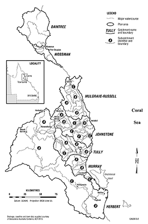
(1)Each part of the plan area that is shown as a catchment area on the map in schedule 1 is a catchment area.(2)A reference in this plan to a catchment area by name is a reference to the catchment area in schedule 1 with that name.
(1)Each part of the plan area that is shown as a subcatchment area of a catchment area on the map in schedule 2 is a subcatchment area of the catchment area.(2)A reference in this plan to a subcatchment area of a catchment area followed by a letter is a reference to the subcatchment area with that letter forming part of that catchment area.
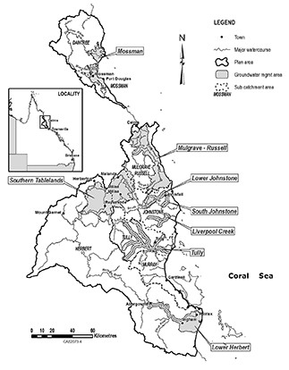
(1)Each part of the plan area that is shown as a groundwater management area on the map in schedule 3 is a groundwater management area.(2)A reference in this plan to a groundwater management area by name is a reference to the groundwater management area in schedule 3 with that name.
The exact location of the boundaries of the plan area, catchment areas, subcatchment areas and groundwater management areas is held in digital electronic form by the department and may be accessed, free of charge, at each office of the department.The location of each office of the department is available at www.dnrm.qld.gov.au.
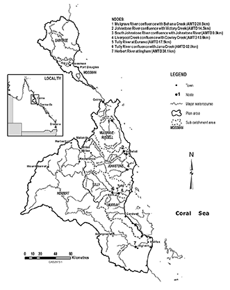
(1)A node mentioned in this plan is a point on a watercourse in the plan area.(2)The location of each node is—(a)shown on the map in schedule 1; and(b)described in schedule 4.(3)Each node is identified on the map by a number.
(1)This plan applies to the following water (surface water) in the plan area—(a)water in a watercourse or lake;(b)water in a spring not connected to water to which the Water Plan (Great Artesian Basin and Other Regional Aquifers) 2017 applies.(2)This plan also applies to groundwater in the plan area.s 10 amd 2016 SL No. 216 s 146 sch 20; 2017 SL No. 164 s 110
11Outcomes for water in plan area
(1)This chapter states the outcomes for the sustainable management of water to which this plan applies.(2)Without limiting subsection (1) or sections 12 to 14, the outcomes include the allocation and management of water in a way that—(a)recognises that the natural state of watercourses, lakes, springs and aquifers has changed because of the taking of, and interfering with, water; and(b)achieves a balance in the following outcomes—(i)the economic outcomes mentioned in section 12;(ii)the social outcomes mentioned in section 13;(iii)the ecological outcomes mentioned in section 14.
Each of the following is an economic outcome for water in the plan area—(a)provision for—(i)the use of water entitlements and other authorisations in the plan area; and(ii)the continued use of existing groundwater works;(b)protection of the probability of being able to take water under a water entitlement;(c)availability of water for the following—(i)growth in industries dependent on water resources in the plan area;Examples of growth in industries dependent on water resources in the plan area—
•irrigated agriculture industries that are dependent on water from the Mossman, Mulgrave–Russell, Johnstone, Tully, Murray and Herbert catchment areas•mining industries that are dependent on water from the Herbert catchment area(ii)Indigenous communities dependent on water resources in the plan area to achieve their economic aspirations;(iii)stock purposes in the plan area;(d)the support of flexible and diverse water supply arrangements for water users;(e)the support of activities stated in the Water Regulation 2016, schedule 3;(f)maintenance of flows that support water-related economic activities in the plan area, including, for example, tourism;(g)encouragement of continual improvement in the efficient use of water;(h)maintenance, to the extent practicable, of the quality of groundwater for consumptive purposes;(i)ensuring a reliable and secure supply of water, including for the Kareeya and the Koombooloomba hydro-electric power stations.s 12 amd 2014 SL No. 142 s 225; 2016 SL No. 216 s 146 sch 2
Each of the following is a social outcome for water in the plan area—(a)increased security for town water supplies that rely on surface water and groundwater;(b)availability of water for the following—(i)population growth in towns and communities dependent on water resources in the plan area;(ii)Indigenous communities dependent on water resources in the plan area to achieve their social aspirations;(iii)domestic purposes in the plan area;(iv)alternative options for town water supply in the Mulgrave–Russell catchment area;(c)maintenance of flows that support water-related aesthetic, cultural and recreational values in the plan area, including the cultural values of the traditional owners in the plan area;(d)maintenance, to the extent practicable, of the quality of water for human use.
(1)Each of the following is an ecological outcome for water in the plan area—(a)the continued capability of a part of the river system to be connected to another, including by maintaining flows that—(i)allow for the movement of native aquatic fauna between riverine, floodplain, wetland, estuarine and marine environments; and(ii)support water-related ecosystems; and(iii)support river-forming processes;(b)provision of a flow regime that ensures—(i)maintenance of fresh water to the estuaries of watercourses and the Great Barrier Reef; and(ii)productivity in the receiving waters of the Great Barrier Reef and inshore reefs;(c)the support of ecosystems dependent on groundwater, including, for example, ecosystems dependent on surface water and groundwater interactions;(d)maintenance of a daily flow at each node of at least 1 megalitre per day to perennial surface water flow;(e)provision of flows and hydraulic habitat for flow-spawning fish and endemic species, including, for example, the Pacific blue-eye (Pseudomugil signifer);(f)minimisation of the impacts of taking water on water-related ecosystems;(g)protection and maintenance of refugia associated with waterholes, lakes and wetlands;(h)minimisation of changes to the natural variability of flows that support—(i)water-related ecosystems; and(ii)riffle habitats; and(iii)the reproduction and nesting activities of the Australian freshwater crocodile (Crocodylus johnstoni).(2)In this section—hydraulic habitat, for flow-spawning fish and endemic species, means the hydraulic or physical attributes of the flow regime that are—(a)required for a particular biological process or response to happen in relation to the fish or species; or(b)necessary to maintain the long-term biological integrity of the fish or species.
15Performance indicators for environmental flow objectives
The performance indicators for the environmental flow objectives are—(a)for assessing periods of low flow—90% non-zero daily flow; and(b)for assessing periods of medium to high flow, the following—(i)mean annual flow;(ii)median annual flow;(iii)1.5 year daily flow volume.
16Environmental flow objectives
The environmental flow objectives for surface water for this plan are stated in schedule 5.
17Performance indicator for water allocation security objectives
The performance indicator for the water allocation security objectives for taking unsupplemented surface water is annual volume probability.
18Water allocation security objectives
(1)The water allocation security objectives are—(a)for water allocation group class A—the annual volume probability be at least 97%; and(b)for water allocation group class B—the annual volume probability be at least 90%; and(c)for water allocation group class C—the annual volume probability be at least 90%; and(d)for water allocation group class D—the annual volume probability be at least 85%.(2)The water allocation group classes are established under section 49.
19Application of pt 1
This part applies to surface water and groundwater.
20Decisions to be consistent with objectives
Decisions made by the chief executive about the allocation or management of water in the plan area, other than a decision about a water permit, must be consistent with—(a)the environmental flow objectives stated in schedule 5; and(b)the water allocation security objectives stated in section 18.
21Assessing impact of decisions
(1)The IQQM computer program’s simulation for the simulation period is used to assess consistency with the environmental flow objectives and the water allocation security objectives.(2)If it is not practicable to use the IQQM computer program, another assessment method approved by the chief executive may be used.(3)The chief executive may approve an assessment method for subsection (2) only if the chief executive is satisfied the method will assess consistency with the objectives at least as accurately as the IQQM computer program.
22Continued effect of moratorium notice—Act, s 46(3)
(1)This section continues, in part, the effect of the moratorium notice published on 18 January 2010 and amended on 31 January 2013.(2)Until the resource operations plan is approved, an application made under section 206 of the Act will not be accepted, if granting the application would have 1 or more of the following effects on water to which this plan applies—(a)increase the amount of water that may be taken;(b)change the location from which water may be taken;(c)increase the rate at which water may be taken;(d)change the flow conditions under which water may be taken;(e)change the purpose for which the water may be taken or interfered with.(3)However, subsection (2) does not apply to an application—(a)to replace a water licence under section 229 of the Act; or(b)to reinstate an expired water licence under section 221 of the Act; or(c)for a water permit; or(d)to subdivide an existing water licence or amalgamate 2 or more existing water licences.
23Particular applications made before 18 January 2010
(1)This section applies to an application—(a)for a water licence to take or interfere with water in the plan area; and(b)made under the Act, or the repealed Act, before 18 January 2010; and(c)not finally decided before the commencement of this plan.(2)However, this section does not apply to an application—(a)for a water licence to interfere with water if—(i)the purpose is to impound water; and(ii)the reason for the impoundment is to generate energy using a micro hydro-electric power scheme; or(b)to which chapter 5, part 2, division 2 applies.(3)The application must be refused if granting the application would have 1 or more of the following effects on water to which this plan applies—(a)increase the amount of water that may be taken;(b)change the location from which water may be taken;(c)increase the rate at which water may be taken;(d)change the flow conditions under which water may be taken;(e)increase or change the interference with the water;(f)change the purpose for which the water may be taken or interfered with.
24Application of div 3
This division applies to unallocated water.
Subdivision 2 Strategic reserve, general reserve, Cape York Indigenous reserve and high flow reserve
25Unallocated water held as strategic reserve, general reserve, Cape York Indigenous reserve and high flow reserve
Unallocated water in the plan area is held as—(a)for the Cape York Peninsula Region—a strategic reserve, a general reserve, a Cape York Indigenous reserve or a high flow reserve; or(b)otherwise—a strategic reserve, a general reserve or a high flow reserve.
26Purpose for which unallocated water may be granted
Unallocated water in the plan area may only be granted for the following purposes—(a)for unallocated water held as a strategic reserve—a State purpose or Indigenous purpose;(b)for unallocated water held as a Cape York Indigenous reserve—an Indigenous purpose;(c)for unallocated water held as a general reserve—any purpose;(d)for unallocated water held as a high flow reserve—any purpose.
(1)The total of the volumetric limits for all water entitlements to take unallocated water are stated in—(a)for water entitlements to take unallocated water for a State purpose from the strategic reserve in a catchment or subcatchment area mentioned in schedule 6, table 1, column 1—schedule 6, table 1, column 2 opposite the area; and(b)for water entitlements to take unallocated water for an Indigenous purpose from the strategic reserve in a catchment area mentioned in schedule 6, table 2, column 1—schedule 6, table 2, column 2 opposite the area; and(c)for water entitlements to take unallocated water from the general reserve in a catchment area mentioned in schedule 6, table 3, column 1—schedule 6, table 3, column 2 opposite the area; and(d)for water entitlements to take unallocated water from the high flow reserve in a catchment area mentioned in schedule 6, table 4, column 1—schedule 6, table 4, column 2 opposite the area.(2)The total of the volumetric limits to take unallocated water from the Cape York Indigenous reserve in the Daintree catchment area is 400ML.
28Period for which water is granted for particular State purpose
(1)This section applies to the volume of water granted from the strategic reserve for either of the following State purposes—(a)a coordinated project;(b)a project of regional significance.(2)The volume of water is granted only for the life of the project and on conclusion of the project the volume of water returns to the strategic reserve.
29Projects that may be considered to be of regional significance
The chief executive may consider a particular project to be a project of regional significance for the plan area only if the chief executive considers the project is significant for a region in the plan area having regard to the following—(a)the outcomes stated in chapter 3;(b)the economic or social impact the project will have on the region;(c)the public interest and the welfare of people in the region;(d)any other relevant consideration.
30Process for granting unallocated water
The process for granting unallocated water is a process stated in the Water Regulation 2016, part 2, division 2, subdivision 2.s 30 amd 2016 SL No. 216 s 146 sch 2
31Taking water for stock or domestic purposes
For section 20A(5) of the Act, an owner of land may take water, in any way, from a watercourse, lake or spring in the plan area for stock or domestic purposes.
32Limitation on taking or interfering with water
For section 20(2) of the Act, the total volume of water that may be taken or interfered with for activities prescribed under a regulation for section 20(2)(a) of the Act is limited to 20ML.
33Application of pt 2
The strategies stated in this part apply to surface water in addition to the strategies stated in part 1.
34Application of div 2
This division applies to an application, made under section 206 of the Act, for a water licence to interfere with water in a watercourse, lake or spring by impounding the flow of water.s 34 amd 2014 SL No. 142 s 226
35Limitations on interference with water
The water licence may be granted only if—
(a)the purpose of the proposed interference is a purpose provided for in this division; or(b)the interference was in existence immediately before 18 January 2010.
36Interference with water to enable taking of water for stock or domestic purposes
(1)This section applies if the purpose of the proposed interference with water is to store water to be taken under an authorisation for stock or domestic purposes.(2)The storage capacity of the proposed interference must not be greater than the following—(a)for a proposed interference in Herbert subcatchment area B—200ML;(b)otherwise—20ML.
37Interference with water for provision of pumping pool
(1)This section applies if the purpose of the proposed interference with water is to provide a pumping pool to enable water to be taken under an authorisation.(2)The storage capacity of the pumping pool must not be greater than the following—(a)for a proposed interference in Herbert subcatchment area B—10ML;(b)otherwise—2ML.(3)In this section—pumping pool means a pool of water near a pump in a watercourse, lake or spring that ensures the water level of the watercourse, lake or spring is appropriate to enable the pump to function properly.
38Interference with water to improve security for town water supply
(1)This section applies if the purpose of the proposed interference with water is to provide improved security for town water supplies taken under an authorisation.(2)The chief executive must not grant the application unless the chief executive is satisfied—(a)the town has appropriate water supply security strategies, such as demand and drought management strategies, in place; and(b)there is a demonstrated need for an increased reliability of the water supply.
39Interference with water to store water for purpose not related to the taking of water under water entitlement
(1)This section applies if the purpose of the proposed interference with water is to store water for a purpose not related to the taking of water under a water entitlement.Examples of a purpose for subsection (1)—
community landscaping, retaining water for flood mitigation purposes or storing water for a micro hydro-electric power scheme(2)The interference must not be greater than the following—(a)if the purpose of the proposed interference is to store water for a micro hydro-electric power scheme—20ML;(b)otherwise—the volume necessary for the purpose of the interference.
40Interference with water related to the granting of unallocated water
(1)This section applies if the purpose of the proposed interference with water is a purpose related to the granting of unallocated water under the process stated in section 30.(2)The interference must not be greater than is necessary for the purpose of taking the unallocated water.
41Application of div 3
This division applies to decisions about replacing authorities or granting water entitlements.
42Water licences to replace local government authorities
(1)This section applies to the authorities mentioned in schedule 7, column 1, continued under section 1037 of the Act.(2)On the commencement of this plan, the chief executive must replace each authority with the water licence to take water described for the authority in schedule 7, column 2.
43Water licence for industrial purpose or amenities purpose at the Kareeya hydro-electric power station
(1)This section applies to the taking of water from the Tully River for—(a)an industrial purpose; or(b)an amenities purpose at the Kareeya hydro-electric power station.(2)The chief executive must grant the following water licences to the owner of the Kareeya hydro-electric power station—(a)a water licence to take water from the Tully River at Tully Falls Weir for an industrial purpose;(b)a water licence to take water from the Tully River at Tully Falls Weir for an amenities purpose.(3)In granting the water licence to take water for an industrial purpose, the chief executive must—(a)have regard to arrangements for maintaining flow over the Tully Falls; and(b)impose conditions on the licence—(i)requiring water taken under the licence, other than water lost during electricity generation, to be returned to the Tully River immediately downstream of the Kareeya hydro-electric power station; and(ii)giving effect to any environmental management rules or water sharing rules included in the resource operations plan.(4)A water licence granted under subsection (2) is subject to—(a)the conditions for the licence stated in schedule 8; and(b)any other conditions imposed by the chief executive in granting a water licence for taking water under section 212 of the Act.s 43 amd 2014 SL No. 142 s 227
44Granting particular water licences to owner of relevant lots
(1)The chief executive must grant the owner of the following lots a water licence to take unsupplemented surface water—(a)lot 2 on SP200254;(b)lot 2 on RP717718.(2)A water licence granted under subsection (1) is subject to the following conditions—(a)for lot 2 on SP200254—the conditions stated in schedule 9, item 1;(b)for lot 2 on RP717718——the conditions stated in schedule 9, item 2.s 44 amd 2014 SL No. 142 s 228
45Granting particular water licence to Tablelands Regional Council
(1)The chief executive must grant the Tablelands Regional Council a water licence to take unsupplemented surface water.(2)A water licence granted under subsection (1) is subject to the conditions stated in schedule 9, item 3.s 45 amd 2014 SL No. 142 s 229
46Purpose of div 4
This division states strategies for particular authorisations to be converted, under section 121 of the Act, to water allocations to take unsupplemented water under the resource operations plan.
47Authorisations to be converted to water allocations
The authorisations to be converted to water allocations to take unsupplemented water are water licences for taking unsupplemented water from, respectively—(a)the Mulgrave River from AMTD 20.5km to AMTD 42.1km; and(b)the Johnstone River from AMTD 14.5km to AMTD 38.0km; and(c)Rankin Creek from AMTD 0.0km to AMTD 9.6km; and(d)Berner Creek from AMTD 0.0km to AMTD 15.3km; and(e)Fisher Creek from AMTD 0.0km to AMTD 17.0km; and(f)Borton Creek from AMTD 0.0km to AMTD 1.7km; and(g)the South Johnstone River from AMTD 0.0km to AMTD 17.5km; and(h)Liverpool Creek from AMTD 13.6km to AMTD 43.0km; and(i)South Liverpool Creek from AMTD 0.0km to AMTD 9.7km; and(j)Cowley Creek from AMTD 0.0km to AMTD 5.3km; and(k)the Tully River from AMTD 0.0km to AMTD 74.5km; and(l)Echo Creek from AMTD 0.0km to AMTD 26.5km; and(m)Davidson Creek from AMTD 0.0km to AMTD 32.8km; and(n)Jarra Creek from AMTD 0.0km to AMTD 47.5km; and(o)Banyan Creek from AMTD 0.0km to AMTD 22.8km; and(p)the Herbert River from AMTD 0.0km to AMTD 83.0km.
48Elements of water allocations
A water allocation to take unsupplemented water must state the following—(a)the daily volumetric limit for the allocation;(b)the annual volumetric limit for the allocation;(c)the conditions, if any, for the allocation.s 48 sub 2014 SL No. 142 s 230
A water allocation to take unsupplemented water in a water management area belongs to the following water allocation group—(a)for an authorisation for which the purpose is to take water for town water supply—(i)for an authorisation held by Cairns Regional Council—water allocation group class D; or(ii)otherwise—water allocation group class A;(b)for an authorisation for which the purpose is to take water for a purpose other than town water supply—(i)for an authorisation that does not state a flow condition—water allocation group class B; or(ii)for an authorisation that does state a flow condition—water allocation group class C.
50Purpose to be stated on a water allocation
The purpose to be stated on a water allocation to take unsupplemented water must be—(a)if the purpose stated on the authorisation is stock, domestic, irrigation, stock intensive, agriculture or a similar purpose—‘rural’; or(b)otherwise—‘any’.
51Nominal volume for a water allocation
In deciding the nominal volume for a water allocation to take unsupplemented water, the chief executive must have regard to the following—(a)the local availability of water;(b)the conditions under which water may be taken under the authorisation;(c)for an authorisation that states any volumetric limits—the stated volumetric limits;(d)the simulated mean annual diversion for the proposed water allocation.
52Daily volumetric limit for a water allocation
(1)The daily volumetric limit for a water allocation to take unsupplemented water is—(a)if the authorisation from which the water allocation is being converted states the volume of water that may be taken in a day—the stated volume; or(b)if the authorisation from which the water allocation is being converted does not state a volume that may be taken in a day, but states a maximum rate, expressed in litres per second—the volume, expressed in megalitres, calculated by multiplying the stated maximum rate by 0.0864; or(c)if the authorisation from which the water allocation is being converted does not state a volume or a maximum rate, but states an authorised activity referring to the capability of a particular pump size mentioned in schedule 10, column 1 to take water—the volume stated in schedule 10, column 2 for the pump size; or(d)if the authorisation from which the water allocation is being converted does not state a volume, a maximum rate or an authorised activity referring to the capability of a particular pump size to take water, but there is a related development permit that states a pump size mentioned in schedule 10, column 1—the volume stated in schedule 10, column 2 for the pump size; or(e)otherwise—the volume decided by the chief executive having regard to—(i)the type of authorisation; and(ii)a measurement, or estimate, of the daily rate at which water is being taken, or is capable of being taken, under the authorisation before the conversion.(2)However, for subsection (1)(c) or (d), if the authorisation holder satisfies the chief executive that the water-taking capacity of the pump is different from the daily volumetric limit under subsection (1), the daily volumetric limit is the volume decided by the chief executive having regard to the following—(a)the conditions under which the water may be taken;(b)the water-taking capacity of the pump to which the authorised activity or development permit relates (the existing pump) under normal operating conditions;(c)the irrigation or water distribution system related to the existing pump during the period of not more than 10 years immediately before the commencement of this plan;(d)the efficiency of the water use associated with the existing pump or the system mentioned in paragraph (c).s 52 amd 2014 SL No. 142 s 231
53Annual volumetric limits for a water allocation
The annual volumetric limit for a water allocation to take unsupplemented water is—(a)if the authorisation from which the water allocation is being converted states the volume of water that may be taken in a period of 12 months—the stated volume; or(b)if the authorisation from which the water allocation is being converted states the area that may be irrigated—the volume decided by the chief executive having regard to the volume of water required for the allocation’s intended purpose, but not more than the volume, expressed in megalitres, calculated by multiplying the area, in hectares, by—(i)for subcatchment area A of the Mulgrave–Russell catchment area—9; or(ii)for subcatchment area B of the Mulgrave–Russell catchment area—8; or(iii)for the Johnstone catchment area—9; or(iv)for the Tully catchment area—9; or(v)for subcatchment area C or D of the Herbert catchment area—5; or(c)if the authorisation from which the water allocation is being converted states both the volume of water that may be taken in a period of 12 months and the area that may be irrigated—the higher of the following—(i)the stated volume under paragraph (a);(ii)the volume decided by the chief executive under paragraph (b) as if only paragraph (b) applied; or(d)otherwise—the volume decided by the chief executive having regard to the following—(i)the conditions under which water may be taken under the authorisation from which the water allocation is being converted;(ii)the water-taking capacity of any works for taking water under the authorisation from which the water allocation is being converted;(iii)the volume required for the allocation’s intended purpose;(iv)the annual volumes of water estimated by the chief executive to have been taken under the authorisation from which the water allocation is being converted during the period, of not more than 10 years, immediately before the commencement of this plan;(v)the efficiency of the use of the water mentioned in subparagraph (iv).
54Elements of water licences to take water from a watercourse, lake or spring
A water licence to take water from a watercourse, lake or spring in the plan area must state the following—(a)for a licence granted under section 43—water may be taken for an industrial or amenities purpose;(b)for any other licence—1 of the following purposes for which the water may be taken under the licence—(i)‘rural’;(ii)‘any’;(c)the daily volumetric limit;(d)the nominal entitlement;(e)the conditions, if any, including requirements for flow conditions and conditions for storing water taken under the licence.s 54 amd 2014 SL No. 142 s 232
55Definition for sdiv 2
In this subdivision—amended water licence means a water licence to take unsupplemented water from a watercourse, lake or spring amended under section 217 of the Act.
56Purpose to be stated on a water licence
The purpose stated on an amended water licence must be—(a)if the purpose stated on the water licence before the amendment is agriculture, irrigation, stock intensive or a similar purpose—‘rural’; or(b)otherwise—‘any’.
The nominal entitlement for an amended water licence is—(a)for an amended water licence that, before the amendment, stated only the volume of water that may be taken in a period of 12 months—the volume stated on the licence before the amendment; or(b)for an amended water licence that, before the amendment, stated only the area that may be irrigated—the volume decided by the chief executive having regard to the volume of water required for the licence’s intended purpose, but not more than the volume, expressed in megalitres, calculated by multiplying the area, in hectares, by—(i)for the Daintree catchment area—6; or(ii)for the Mossman catchment area—6; or(iii)for subcatchment area A of the Mulgrave–Russell catchment area—9; or(iv)for subcatchment area B or C of the Mulgrave–Russell catchment area—8; or(v)for subcatchment area D of the Mulgrave–Russell catchment area—9; or(vi)for the Johnstone catchment area—9; or(vii)for the Tully catchment area—9; or(viii)for the Murray catchment area—9; or(ix)for subcatchment area A of the Herbert catchment area—9; or(x)for subcatchment area B of the Herbert catchment area—12; or(xi)for subcatchment area C or D of the Herbert catchment area—5; or(c)for an amended water licence that, before the amendment, stated both the volume of water that may be taken in a period of 12 months and the area that may be irrigated—the higher of the following—(i)the stated volume under paragraph (a);(ii)the volume decided by the chief executive under paragraph (b) as if only paragraph (b) applied; or(d)otherwise—the volume decided by the chief executive having regard to the following—(i)the conditions under which water may be taken under the licence;(ii)the water-taking capacity of any works for taking water under the licence;(iii)the volume required for the licence’s intended purpose;(iv)the annual volumes of water estimated by the chief executive to have been taken under the licence during the period, of not more than 10 years, immediately before the commencement of this plan;(v)the efficiency of the use of the water mentioned in subparagraph (iv).
58Daily volumetric limit for a water licence
The daily volumetric limit to take unsupplemented water for an amended water licence is the daily volumetric limit mentioned in section 52 or decided by the chief executive under that section as if the amended water licence were a water allocation.s 58 sub 2014 SL No. 142 s 233
59Conditions for amended water licences
In deciding the conditions under which water may be taken under an amended water licence, the chief executive must consider the conditions stated on the water licence being amended.
60Application and purpose of pt 3
This part—(a)applies only to groundwater in a groundwater management area; and(b)states the strategies for achieving the outcomes mentioned in chapter 3.
61Limitation on taking or interfering with groundwater—Act, s 20(2)
(1)This section limits the groundwater that may be taken or interfered with under section 20(2) of the Act.(2)A person may only take or interfere with groundwater in a groundwater management area—(a)under a water permit; or(b)under a water entitlement; or(c)under section 68; or(d)for stock or domestic purposes; or(e)for an activity prescribed under a regulation for section 20(2)(a) of the Act.
s 62 amd 2014 Act No. 29 s 162
om 2016 SL No. 216 s 146 sch 20
(1)A water licence to take groundwater must state—(a)1 of the following purposes for which the water may be taken under the licence—(i)‘rural’;(ii)‘any’; and(b)the nominal entitlement; and(c)the conditions, if any.(2)However, subsection (1) does not apply to a water licence granted for the purpose of mine dewatering under section 206 of the Act.
64Definition for sdiv 2
In this subdivision—amended water licence means a water licence to take groundwater amended under section 217 of the Act.
65Purpose to be stated on a water licence
The purpose stated on an amended water licence must be—(a)if the purpose stated on the water licence is agriculture, irrigation, stock intensive or a similar purpose—‘rural’; or(b)otherwise—‘any’.
66Conditions for amended water licences
In deciding the conditions under which water may be taken under an amended water licence, the chief executive must consider the conditions stated on the water licence being amended.
67Definitions for sdiv 3
In this subdivision—prescribed existing groundwater works means works the chief executive is satisfied were—(a)used or capable of being used to take groundwater for a purpose, other than stock or domestic purposes, from a prescribed groundwater management area; and(b)in existence on 20 June 2012.prescribed groundwater management area means any part of the following groundwater management areas in which, before the commencement of this plan, a water licence was not required to take groundwater—(a)Mulgrave–Russell groundwater management area;(b)Southern Tablelands groundwater management area;(c)Lower Johnstone groundwater management area;(d)South Johnstone groundwater management area;(e)Liverpool Creek groundwater management area;(f)Tully groundwater management area;(g)Lower Herbert groundwater management area.
68Taking groundwater using prescribed existing groundwater works
(1)This section applies to an owner of land on which there are prescribed existing groundwater works.(2)The owner may continue to take groundwater using the works for 60 business days after the commencement of this plan.(3)Also, if the owner gives the chief executive notice, in the approved form, of the works and the taking of water using the works, the owner may continue to use the works to take groundwater—(a)after the notice is given; and(b)until the owner is granted a water licence under section 69.
69Granting water licences for using prescribed existing groundwater works
The chief executive may, under section 212 of the Act, grant a water licence to a person authorised under section 68(3) to continue taking groundwater.
70Nominal entitlements for authorisations
(1)This section applies if the chief executive grants a water licence to a person under section 69.(2)The chief executive must decide the nominal entitlement for the water licence.(3)In deciding the nominal entitlement for the licence, the chief executive must consider each of the following—(a)any other water entitlements for the land to which the licence relates;(b)the density of water bores for taking groundwater in the area to which the entitlement relates;(c)any unsupplemented water allocations in the area to which the entitlement relates;(d)the estimated volume.(4)If the chief executive is satisfied the volume of groundwater taken during the relevant period is more than the volume estimated under subsection (3)(d), the chief executive may decide a nominal entitlement that is more than the estimated volume.(5)In this section—estimated volume means—(a)for prescribed existing works used to take groundwater for irrigation purposes—the volume of groundwater taken using the works for irrigation purposes during the relevant period, if the volume is not more than—(i)in the Mulgrave–Russell groundwater management area—(A)in subcatchment area A of the Mulgrave–Russell catchment area—9ML of water for each irrigable hectare of property; or(B)in subcatchment area B or C of the Mulgrave–Russell catchment area—8ML of water for each irrigable hectare of property; or(C)in subcatchment area D of the Mulgrave–Russell catchment area—9ML of water for each irrigable hectare of property; or(ii)in the Lower Johnstone groundwater management area—9ML of water for each irrigable hectare of property; or(iii)in the South Johnstone groundwater management area—9ML of water for each irrigable hectare of property; or(iv)in the Liverpool Creek groundwater management area—9ML of water for each irrigable hectare of property; or(v)in the Tully groundwater management area—9ML of water for each irrigable hectare of property; or(vi)in the Southern Tablelands groundwater management area—9ML of water for each irrigable hectare of property; or(vii)in the Lower Herbert groundwater management area—5ML of water for each irrigable hectare of property; or(b)for prescribed existing works used to take groundwater for a purpose other than irrigation purposes—the volume of groundwater estimated to have been taken using the works during the relevant period for the purpose.relevant period means each 1-year period during the period of not more than 10 years immediately before the commencement of this plan.
71Monitoring and reporting requirements
(1)To help the Minister assess the effectiveness of the management strategies for achieving the outcomes mentioned in chapter 3, the resource operations plan must state the monitoring requirements for water and natural ecosystems for this plan.(2)Subsection (1) does not limit the monitoring requirements the chief executive may impose for this plan.s 71 amd 2014 SL No. 142 s 234
s 72 om 2016 SL No. 216 s 146 sch 20
(1)This section states the proposed arrangements for implementing this plan.(2)After the commencement of this plan, it is proposed to include in the resource operations plan—(a)a process to grant, or convert authorisations to, water allocations to take water from locations mentioned in section 47; and(b)provisions to implement the monitoring requirements mentioned in chapter 6.(3)Before the resource operations plan commences, the chief executive may, before proceeding with a process of a type mentioned in section 30, have regard to whether it is appropriate to proceed with the process in the absence of the resource operations plan.
74Minor or stated amendment of plan—Act, s 57
The following types of amendment may be made to this plan under section 57(b) of the Act—(a)an amendment or addition of an environmental flow objective if the amendment or addition achieves an equivalent or improved ecological outcome without adversely affecting—(i)the outcomes mentioned in chapter 3; or(ii)the water allocation security objective mentioned in section 18;(b)an amendment or addition of a water allocation security objective if the amendment or addition does not adversely affect—(i)the outcomes mentioned in chapter 3; or(ii)the environmental flow objectives mentioned in section 16;(c)an amendment or addition of a node;(d)an amendment to subdivide a subcatchment area;(e)an amendment to adjust the boundaries of a groundwater management area if more accurate information about the boundaries of the plan area or hydrological characteristics of the plan area becomes available;(f)an amendment or addition of a water allocation group;(g)an amendment or addition of a groundwater management area;(h)an amendment or addition of a monitoring or reporting requirement under chapter 6;(i)an amendment of, or to remove, a redundant provision of this plan;(j)an amendment to omit a provision relating to the grant, amendment or conversion of an authorisation if the grant, amendment or conversion under the provision has been completed.
sections 4, 5 and 9(2)(a)
sch 1 sub 2014 SL No. 142 s 235
sch 3 sub 2014 SL No. 142 s 236
section 9(2)(b)
Column 1 | Column 2 |
Node | Location |
1 | Mulgrave River confluence with Behana Creek (AMTD 20.5km) |
2 | Johnstone River confluence with Victory Creek (AMTD 14.5km) |
3 | South Johnstone River confluence with Johnstone River (AMTD 0.0km) |
4 | Liverpool Creek confluence with Cowley Creek (AMTD 13.6km) |
5 | Tully River at Euramo (AMTD 17.5km) |
6 | Tully River confluence with Jarra Creek (AMTD 32.0km) |
7 | Herbert River at Ingham (AMTD 30.1km) |
sections 16 and 20(a)
At each node mentioned in table 1, column 1, the percentage of the total number of days in the simulation period that the 90% non-zero daily flow is equalled or exceeded be at least the percentage stated, for the node, in table 1, column 2.Table 1
Column 1 | Column 2 |
Node | 90% non-zero daily flow |
1 | 80 |
2 | 81 |
3 | 81 |
4 | 82 |
5 | 82 |
6 | 85 |
7 | 83 |
(a)the mean annual flow in the simulation period, expressed as a percentage of the mean annual flow for the pre-development flow pattern, be at least the percentage stated for the node in table 2, column 2; and
(b)the median annual flow in the simulation period, expressed as a percentage of the median annual flow for the pre-development flow pattern, be at least the percentage stated for the node in table 2, column 3; and
(c)the 1.5 year daily flow volume in the simulation period, expressed as a percentage of the 1.5 year daily flow volume for the pre-development flow pattern, be at least the percentage stated for the node in table 2, column 4.
Table 2
Column 1 | Column 2 | Column 3 | Column 4 |
Node | Mean annual flow percentage | Median annual flow percentage | 1.5 year daily flow volume percentage |
1 | 92 | 91 | 96 |
2 | 93 | 91 | 93 |
3 | 92 | 91 | 94 |
4 | 95 | 96 | 98 |
5 | 94 | 91 | 92 |
6 | 97 | 97 | 95 |
7 | 93 | 91 | 94 |
Table 1
Column 1 | Column 2 |
Catchment or subcatchment | Total volume of strategic unallocated water for State purposes (ML) |
Daintree | 150 |
Mossman | 2,000 |
Mulgrave–Russell subcatchment B | 15,000 |
Mulgrave–Russell subcatchment D | 2,000 |
Johnstone subcatchment A | 500 |
Johnstone subcatchment E | 2,000 |
Johnstone subcatchment F | 600 |
Tully subcatchment B | 1,000 |
Murray subcatchment A | 200 |
Herbert subcatchment A | 1,750 |
Herbert subcatchment B | 5,200 |
Herbert subcatchment C | 4,000 |
Herbert subcatchment D | 1,500 |
Table 2
Column 1 | Column 2 |
Catchment | Total volume of strategic unallocated water for Indigenous purposes (ML) |
Daintree | 100 |
Mossman | 1,000 |
Mulgrave–Russell | 1,000 |
Johnstone | 1,100 |
Tully | 500 |
Murray | 500 |
Herbert | 1,000 |
Table 3
Column 1 | Column 2 |
Catchment | Total volume of general unallocated water (ML) |
Daintree | 100 |
Mossman | 1,000 |
Mulgrave–Russell | 3,000 |
Johnstone | 3,300 |
Tully | 7,000 |
Murray | 200 |
Herbert | 1,750 |
Table 4
Column 1 | Column 2 |
Catchment | Total volume of high flow unallocated water (ML) |
Daintree | 25,000 |
Mossman | 25,000 |
Mulgrave–Russell | 175,000 |
Johnstone | 190,000 |
Tully | 180,000 |
Murray | 30,000 |
Herbert | 245,000 |
Column 1 | Column 2 |
Authority | Water licence to take water |
Order-in-Council 90 | licensee—Cassowary Coast Regional Council watercourse—Boulder Creek location—Tully purpose—any daily volumetric limit—4.55ML nominal entitlement—1,364ML water year—1 July to 30 June |
Order-in-Council 277 | licensee—Cassowary Coast Regional Council watercourse—Meunga Creek location—Cardwell purpose—any daily volumetric limit—5.6ML nominal entitlement—1,400ML water year—1 July to 30 June |
Order-in-Council 253 | licensee—Cassowary Coast Regional Council watercourse—Jurs Creek location—Mission Beach and Bingil Bay purpose—any daily volumetric limit—1.5ML nominal entitlement—250ML water year—1 July to 30 June |
Order-in-Council 96 | licensee—Cassowary Coast Regional Council watercourse—Nyletta Creek location—Silkwood, El Arish and Kurrimine Beach purpose—any daily volumetric limit—3.64ML nominal entitlement—546ML water year—1 July to 30 June |
Order-in-Council 95 | licensee—Cassowary Coast Regional Council watercourse—Johnstone River location—Innisfail and surrounding townships purpose—any daily volumetric limit—20.4ML nominal entitlement—3,410ML water year—1 July to 30 June |
Order-in-Council 144 | licensee—Hinchinbrook Shire Council watercourse—Herbert River location—Ingham purpose—any daily volumetric limit—18.41ML nominal entitlement—2,987ML water year—1 July to 30 June |
Order-in-Council 151 | licensee—Tablelands Regional Council watercourse—Johnstone River location—Malanda purpose—any daily volumetric limit—2.7ML nominal entitlement—332ML water year—1 July to 30 June |
Order-in-Council 149 | licensee—Tablelands Regional Council watercourse—North Beatrice River location—Millaa Millaa purpose—any daily volumetric limit—1.6ML nominal entitlement—200ML water year—1 July to 30 June |
Order-in-Council 259 | licensee—Tablelands Regional Council watercourse—Johnstone River location—Johnstone River Estate purpose—any daily volumetric limit—0.31ML nominal entitlement—70ML water year—1 July to 30 June |
Order-in-Council 279 | licensee—Tablelands Regional Council watercourse—North Cedar Creek location—Ravenshoe purpose—any daily volumetric limit—2ML nominal entitlement—480ML water year—1 July to 30 June |
Order-in-Council 280 | licensee—Tablelands Regional Council watercourse—The Millstream location—Ravenshoe purpose—any daily volumetric limit—2ML nominal entitlement—120ML water year—1 July to 30 June |
Order-in-Council 89 | licensee—Tablelands Regional Council watercourse—Wild river location—Herberton purpose—any daily volumetric limit—1.06ML nominal entitlement—365ML water year—1 July to 30 June |
Order-in-Council 107 | licensee—Tablelands Regional Council watercourse—Return Creek location—Tabo purpose—any daily volumetric limit—0.68ML nominal entitlement—91ML water year—1 July to 30 June |
section 43(4)
Item | Limitation |
1 | licensee—Stanwell Corporation activity—the taking of water from the Tully River on, or on adjoining, land described as lot 32 on CWL3693 description of land—water under this licence is not attached to land purpose—industrial daily volumetric limit—3,024ML conditions— (1) The licensee must comply with all the relevant provisions contained in the resource operations plan. (2) Water taken, other than water lost during electricity generation, must be returned to the Tully River immediately downstream of the Kareeya hydro-electric power station. |
2 | licensee—Stanwell Corporation activity—the taking of water from the Tully River on, or on adjoining, land described as lot 32 on CWL3693 description of land—water under this licence is not attached to land purpose—amenities nominal entitlement—6ML daily volumetric limit—0.02ML condition—The licensee must comply with all the relevant provisions contained in the resource operations plan for taking water from the Tully River. |
section 44(2) and 45(2)
Item | Conditions |
1 | location—lot 2 on SP200254 watercourse—UT Trebonne Creek attached land—lot 2 on SP200254, lot 1 on RP706323, lot 2 on RP708114, lot 3 on RP708114 and lot 5 on RP804450 purpose—rural nominal entitlement—200ML daily volumetric limit—3.9ML water year—1 July to 30 June condition—Water taken under the licence may be used on the attached land. |
2 | location—lot 2 on RP717718 watercourse—UT Wright Creek purpose—rural nominal entitlement—12ML daily volumetric limit—1.5ML water year—1 July to 30 June |
3 | licensee—Tablelands Regional Council watercourse—The Millstream location—Millstream Estate purpose—any nominal entitlement—295ML daily volumetric limit—0.81ML water year—1 July to 30 June |
sections 52(1) and 58(1)
Column 1 | Column 2 |
Nominal pump size (mm) | Daily volumetric limit (ML/day) |
32 | 0.6 |
40 | 1 |
50 | 1.5 |
65 | 3.5 |
80 | 3.9 |
100 | 6.9 |
125 | 7.8 |
150 | 12.1 |
200 | 15.6 |
250 | 21.6 |
300 | 25.9 |
350 | 30.2 |
375 to 400 | 37.2 |
500 | 47.5 |
600 to 610 | 86.4 |
650 to 660 | 120 |
700 to 720 | 150 |
750 to 770 | 180 |
780 to 810 | 200 |
1.5 year daily flow volume, for a node, means the daily flow, at the node, that has a 67% probability of being reached at least once a year.
90% non-zero daily flow, for a node, means the daily flow, at the node, that is equalled or exceeded on 90% of the days on which there is a flow under the pre-development flow pattern.
adopted middle thread distance means the distance in kilometres, measured along the middle of a watercourse, that a specific point in the watercourse is, at the commencement of this plan, from—
(a)the watercourse’s mouth; or
(b)if the watercourse flows into another watercourse—the watercourse’s confluence with the other watercourse.
amended water licence—
(a)for chapter 5, part 2, division 5, subdivision 2, see section 55; or
(b)for chapter 5, part 3, division 2, subdivision 2, see section 64.
AMTD means the adopted middle thread distance.
annual variability, for a flow at a point in a watercourse, means the amount of change in the flow that happens between years.
annual volume probability, for a water allocation group, means the percentage of years in the simulation period in which the volume of water that may be taken by the group is at least the total of the nominal volumes for the allocations in the group.
annual volumetric limit, for a water allocation, means the maximum volume of water that may be taken under the allocation in a water year.
authorisation means a water licence, water permit, interim water allocation or other authority to take water given under the Act or the repealed Act, other than a water permit for stock or domestic purposes.
Cape York Peninsula Region see Cape York Peninsula Heritage Act 2007, section 7(1).
catchment area means a catchment area under section 5.
coordinated project means a coordinated project under the State Development and Public Works Organisation Act 1971.
daily flow, for a node, means the volume of water, expressed in megalitres, that flows past the node in a day.
daily volumetric limit, for a water entitlement, means the maximum volume of water that may be taken under the entitlement in a day.
discharge, for a flow at a point in a watercourse, means the rate at which water passes the point, measured in cubic metres per second or megalitres per day.
event duration, for a flow at a point in a watercourse, means the period of time when the discharge is greater than or less than the level necessary for a particular ecological process to happen.
existing groundwater works means—
(a)works that are prescribed existing groundwater works for chapter 5, part 3, division 2, subdivision 3; and
(b)works, other than prescribed existing groundwater works, that were in existence immediately before the commencement of this plan.
flow regime means the entire range of flows at a point in a watercourse including variations in the watercourse height, discharge, seasonality, annual variability and event duration.
groundwater means underground water not connected to artesian water.
sch 11 def groundwater amd 2016 SL No. 216 s 146 sch 20
groundwater management area see section 7.
Indigenous purpose means the purpose of helping an Indigenous community achieve its economic and social aspirations.
in-stream works means works constructed within the banks of a watercourse.
IQQM computer program means the department’s Integrated Quantity and Quality Modelling computer program, and associated statistical analysis and reporting programs, that simulate daily stream flows, flow management, storages, releases, in-stream infrastructure, water diversions, water demands and other hydrologic events in the plan area.
mean annual flow, for a node, means the total volume of flow, at the node, in the simulation period divided by the number of years in the simulation period.
median annual flow, for a node, means the annual flow volume, at the node, that is equalled or exceeded in 50% of years in the simulation period.
micro hydro-electric power scheme means a scheme that—
(a)generates hydro-electricity, using in-stream works, for domestic or business needs; and
(b)has a power plant capacity of less than 100 kilowatts; and
(c)is in an area that is off-grid and outside Ergon Energy’s distribution area under its distribution authority.
node see section 9.
nominal entitlement see the Water Regulation 2016, section 28.
sch 11 def nominal entitlement amd 2016 SL No. 216 s 146 sch 20
pre-development flow pattern means the pattern of water flows, during the simulation period, decided by the chief executive using the IQQM computer program as if—
(a)there were no dams or other water infrastructure in the plan area; and
(b)no water was taken under authorisations in the plan area.
prescribed existing groundwater works, for chapter 5, part 3, division 2, subdivision 3, see section 67.
prescribed groundwater management area, for chapter 5, part 3, division 2, subdivision 3, see section 67.
project of regional significance means a project the chief executive considers to be a project of regional significance under section 29.
refugia means the habitats required by a species during a time of stress, including, for example, drought.
resource operations plan means the resource operations plan to implement this plan.
See the Act, section 1266.
sch 11 def resource operations plan amd 2016 SL No. 216 s 146 sch 20
seasonality, for a flow in a watercourse, means the time of year when the flow happens.
simulated mean annual diversion, for an authorisation or group of authorisations, means the total volume of water simulated to have been taken under the authorisations, if the authorisations were in existence for the whole of the simulation period, divided by the number of years in the simulation period.
simulation period means the period from 1 January 1890 to 30 June 2008.
State purpose means—
(a)a coordinated project; or
(b)a project of regional significance; or
(c)town water supply use.
subcatchment area see section 6.
supplemented water means water supplied under an interim resource operations licence, resource operations licence or other authority to operate water infrastructure.
surface water see section 10(1).
this plan see section 1.
traditional owners, in the plan area, means the Aboriginal people who identify as descendants of the original inhabitants of the area.
unsupplemented surface water means surface water that is unsupplemented water.
unallocated water means water available for allocation in the plan area.
unsupplemented water means water that is not supplemented water.
unsupplemented water allocation means a water allocation to take unsupplemented water.
waterhole means a part of a watercourse that contains water after the watercourse ceases to flow, other than a part of a watercourse that is within the storage area of a dam on the watercourse.