


This water plan may be cited as the Water Plan (Mitchell) 2007.s 1 sub 2014 Act No. 64 s 255 sch 2
The following are the purposes of this plan—(a)to define the availability of water in the plan area;(b)to provide a framework for sustainably managing water and the taking of water;(c)to identify priorities and mechanisms for dealing with future water requirements;(d)to provide a framework for reversing, where practicable, degradation that has occurred in natural ecosystems;(e)to regulate the taking of overland flow water;(f)to regulate the taking of groundwater.
The dictionary in schedule 7 defines particular words used in this plan.
This plan applies to the area shown as the plan area on the map in schedule 1.
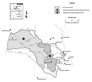
Each part of the plan area that is within a groundwater management area shown on the map in schedule 2 is a groundwater management area for this plan.
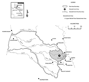
The part of the plan area that is within the subcatchment area shown on the map in schedule 3 is a subcatchment area for this plan.
7Declaration about watercourse—Act, s 1006(2)
(1)Groundwater in an aquifer under a prescribed watercourse, or under land within the prescribed distance of a prescribed watercourse, is declared to be water in the watercourse.(2)Subsection (1) does not apply to water the chief executive is satisfied is not hydraulically connected to the water in the watercourse.(3)In this section—prescribed distance means—(a)for a prescribed watercourse that is a river—1km; or(b)for a prescribed watercourse that is a creek—200m.prescribed watercourse means each of the following—(a)Mitchell River;(b)Walsh River;(c)Lynd River;(d)Palmer River;(e)Alice River;(f)Mary Creek;(g)Bushy Creek;(h)Rifle Creek.
(1)The exact location of the boundaries of the plan area, groundwater management areas, and the subcatchment area, is held in digital electronic form by the department.(2)The information held in digital electronic form can be reduced or enlarged to show the details of the boundaries.
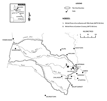
(1)A node mentioned in this plan is a place on a watercourse in the plan area.(2)The location of each node is shown on the map in schedule 1 and described in schedule 4.(3)Each node is identified on the map by a number.
(1)This plan applies to the following water (surface water) in the plan area—(a)water in a watercourse or lake;(b)water in springs not connected to GAB water;(c)overland flow water, other than water in springs connected to GAB water.(2)This plan also applies to underground water that is not GAB water (groundwater) in the plan area.(3)In this section—GAB water means underground water to which the Water Plan (Great Artesian Basin and Other Regional Aquifers) 2017 applies.s 10 sub 2016 SL No. 216 s 146 sch 20
amd 2017 SL No. 164 s 101
11Outcomes for water in plan area
Water is to be allocated and sustainably managed in a way that—(a)recognises the natural state of watercourses, lakes, springs and aquifers has changed because of water infrastructure and the taking of water; and(b)seeks to achieve a balance in the following outcomes—(i)the general outcomes mentioned in section 12;(ii)the general ecological outcomes mentioned in sections 13 and 14;(iii)the specific ecological outcomes mentioned in sections 15.
Each of the following is a general outcome for water in the plan area—(a)to provide for the use of all water entitlements and other authorisations in the plan area;(b)to provide for the continued use of all existing overland flow works;(c)to provide for the continued use of all existing water bores;(d)to make water available to support growth in industries dependent on water in the plan area;(e)to make water in Lake Mitchell available to be taken;(f)to make water available to support population growth in towns and communities dependent on water in the plan area;(g)to make water available to support growth in irrigated agriculture;(h)to make water available for helping indigenous communities in the Cape York Peninsula Region area to achieve their economic and social aspirations;(i)to encourage continual improvement in the efficient use of water;(j)to support water-related cultural values of Aboriginal and Torres Strait Islander communities in the plan area;(k)to support tourism in the plan area, including, for example, by protecting flows that support the natural aesthetics of watercourses and their surroundings;(l)to support commercial fishing in the Gulf of Carpentaria, including, for example, by protecting flood flows that may deliver nutrients and water to estuarine and marine environments to stimulate growth and movement of native aquatic animals, including fish, prawns and crabs;(m)to ensure water is available to support natural ecosystem processes;(n)to allocate and manage water in the upper Walsh River and the upper Mitchell River in a way that is compatible with the outcomes of the Water Resource (Barron) Plan 2002 to the greatest practicable extent.
13General ecological outcomes for both surface water and groundwater
(1)Each of the following is a general ecological outcome for water in the plan area—(a)to maintain the natural variability of flows that support the habitats of native plants and animals and migratory birds in watercourses, floodplains, wetlands, lakes and springs;(b)to provide for the continued capability of one part of a river system to be connected to another, including by maintaining flood flows that—(i)allow for the movement of native aquatic animals between riverine, floodplain, wetland, estuarine and marine environments; and(ii)deliver nutrients and organic matter throughout the plan area to support natural processes such as breeding, growth and migration in riverine, floodplain, wetland, estuarine and marine environments; and(iii)deliver water and sediment throughout the plan area to support river-forming processes;(c)to minimise changes to natural variability in water levels and to support natural ecological processes, including maintaining refugia associated with waterholes and lakes;(d)to maintain the permanence of water in naturally perennially flowing watercourses and in river bed sands that provide water to support native plants and animals, particularly during dry seasons;(e)to promote improved understanding of the matters affecting flow-related health of ecosystems within the plan area.(2)In this section—refugia means the habitat required by a species during a time of stress, for example, drought.
14General ecological outcomes for groundwater only
Each of the following is a general ecological outcome for groundwater in the plan area—(a)to maintain groundwater contributions to the flow of water in watercourses, lakes and springs;(b)to support the ecosystems dependent on groundwater, including, for example, riparian vegetation, wetlands and waterholes;(c)to allocate and manage groundwater in a way that is compatible with the outcomes of the Water Plan (Great Artesian Basin and Other Regional Aquifers) 2017 to the greatest practicable extent.s 14 amd 2017 SL No. 164 s 102
15Specific ecological outcomes
Each of the following is a specific ecological outcome for water in the plan area—(a)to maintain the cultural, ecological and tourism values of the cave ecosystems of the Chillagoe-Mungana Caves National Park;(b)to maintain flood flows to the estuarine and marine environments of the Gulf of Carpentaria to stimulate breeding, growth and migration of native aquatic animals;(c)to maintain the natural variability of flood flows that inundate, and deliver nutrients, organic matter and sediment to, the wetlands of the areas known as the Mitchell River Fan Aggregation and the Southeast Karumba Plain Aggregation.
16Application of pt 1
This part applies to both surface water and groundwater.
s 17 om 2014 SL No. 142 s 166
18Matters to be considered for environmental management rules
(1)In deciding the environmental management rules to be included in the resource operations plan, the chief executive must consider—(a)the streamflows required to maintain the following—(i)the longitudinal connectivity of low flow habitats throughout river systems in the plan area;(ii)the wetted habitats at riffles and other streambed features;(iii)the natural seasonality of flows and zero flows;(iv)the replenishment of refuge pools that enable movement of instream biota;(v)groundwater flows;(vi)the contributions from aquifers to the flow of water in watercourses;(vii)the lateral connectivity between rivers in the plan area and their adjacent riverine environments, including floodplains; and(b)the impact the taking of, or proposed taking of, or interfering with, water may have on the following—(i)water quality;(ii)the natural movement of sediment;(iii)the bed and banks of a watercourse or lake;(iv)the inundation of habitats;(v)the movement of fish and other aquatic animals;(vi)the recreation and aesthetic values of the plan area;(vii)cultural values including, for example, cultural values of local Aboriginal or Torres Strait Islander communities.(2)Subsection (1) does not limit the matters the chief executive may consider.
19Matters to be considered for water sharing rules
(1)In deciding the water sharing rules to be included in the resource operations plan for authorisations to take water in a part of the plan area, the chief executive must consider—(a)any existing water sharing arrangements; and(b)the local availability of water that may be taken from streamflows, waterholes, bed sands or aquifers; and(c)the conditions for taking water decided under section 43, 50 or 51; and(d)the daily volumetric limits decided under section 48; and(e)the annual volumetric limits decided under section 49 or 63; and(f)the impact on authorisations to take water in the plan area; and(g)for rules relating to surface water in Mary Creek, Bushy Creek or Rifle Creek or in the Mitchell River between nodes 1 and 2—the water that is available for taking during dry seasons.(2)Subsection (1) does not limit the matters the chief executive may consider.
ch 4 pt 1 div 2 hdg om 2014 SL No. 142 s 167
s 20 om 2014 SL No. 142 s 167
s 21 om 2014 SL No. 142 s 167
22Projects that may be considered to be of regional significance
The chief executive may consider a particular project to be a project of regional significance for the plan area only if the chief executive considers the project is significant for a region in the plan area, having regard to the following—(a)the outcomes under chapter 3;(b)the economic or social impact the project will have on the region;(c)the public interest and the welfare of people in the region;(d)any other relevant matter.
23Unallocated water held as indigenous, strategic or general reserve
(1)Unallocated water in the Mitchell River upstream of node 1 is held as a general reserve.(2)Unallocated water in another part of the plan area is held as—(a)if the unallocated water is in the Cape York Peninsula Region area—either an indigenous reserve, a strategic reserve or a general reserve; or(b)otherwise—either a strategic reserve or a general reserve.
s 24 om 2014 SL No. 142 s 168
25Preparing and implementing process in resource operations plan generally
(1)Unallocated water may be dealt with only under a process in the resource operations plan.(2)In preparing and implementing the process, the chief executive must consider the following—(a)the purpose for which the water is required;(b)the efficiency of existing and proposed water use practices;(c)the extent to which water in the plan area is being taken under authorisations;(d)the availability of an alternative water supply for the purpose for which the water is required;(e)the impact the proposed taking of, or interfering with, the water may have on existing water users in the plan area;(f)whether the proposed taking or interfering is likely to have a direct adverse effect on groundwater flows;(g)the matters mentioned in section 18(1)(a) and (b).(3)The resource operations plan must state that use, for irrigation, of water taken under a water licence granted under the process requires a land and water management plan approved under section 77 of the Act.(4)Subsection (1) does not limit the matters the chief executive may consider.
s 26 om 2014 SL No. 142 s 169
27Purpose for which indigenous unallocated water may be granted
Unallocated water held as an indigenous reserve (indigenous unallocated water) may be granted only for helping indigenous communities in the Cape York Peninsula Region area to achieve their economic and social aspirations.
28Volumetric limits for indigenous unallocated water
The total of the annual volumetric limits for all water licences to take indigenous unallocated water from the Cape York Peninsula Region area is 5,000ML.
29Purpose for which strategic unallocated water may be granted
Unallocated water held as a strategic reserve (strategic unallocated water) may be granted only if it is to be taken for a State purpose.
30Volumetric limits for strategic unallocated water
The total of the annual volumetric limits for all water licences to take strategic unallocated water is 10,000ML.
31Period for which strategic unallocated water is granted for particular State purpose
(1)This section applies to water licences to take strategic unallocated water granted for either of the following State purposes—(a)a project of State significance;(b)a project of regional significance.(2)Water granted for a project is granted only for the life of the project and the right to take the water returns to the State on the conclusion of the project.
32Purpose for which general unallocated water may be granted
Unallocated water held as a general reserve (general unallocated water) may be granted for any purpose.
33Volumetric limits for general unallocated water in Mitchell River upstream of node 1
The total of the annual volumetric limits for all water licences to take general unallocated water from the Mitchell River upstream of node 1 is 20,000ML.
34Volumetric limits for general unallocated water in other parts of plan area
The total of the annual volumetric limits for all water licences to take general unallocated water from a part of the plan area other than the Mitchell River upstream of node 1 is 35,000ML.
35Application of pt 2
The strategies stated in this part apply to surface water in addition to the strategies stated in part 1.
36Accepting and deciding particular applications to interfere with water
(1)This section applies to the chief executive in making a decision about an application to interfere with, or increase the interference with, surface water in a watercourse, waterhole, lake or spring by impounding the flow of the water.(2)The chief executive may accept and decide the application only if the purpose of the proposed interference or increase in interference is—(a)to store water for stock or domestic purposes; or(b)to provide a pumping pool to enable water to be taken under an authorisation in existence at the commencement of this plan; or(c)to store water for a purpose not related to the taking of water under a water entitlement.Examples of a purpose for subsection (2)(c)—
community landscaping or retaining water for flood mitigation purposes(3)The chief executive may approve the application if—(a)the chief executive is satisfied the proposed interference or increase in interference is necessary for a purpose mentioned in subsection (2); and(b)the proposed storage capacity is no greater than is necessary for the purpose of the proposed interference or increase in interference having regard to—(i)the impact the proposed interference or increase in interference may have on the following—(A)instream water levels;(B)the natural movement of sediment;(C)the bed and banks of a watercourse or lake;(D)riparian vegetation;(E)habitat for native plants and animals;(F)movement of fish and other aquatic species;(G)cultural and ecological values of the watercourse, waterhole, lake or spring; and(ii)for a purpose mentioned in subsection (2)(a)—(A)existing water supplies for the property to which the application relates, including existing weirs, groundwater and dams taking overland flow water; and(B)the availability of water at the proposed storage site.(4)However, the chief executive must not approve an application for a proposed interference or increase in interference for a purpose mentioned in subsection (2)(b) or (c) if the proposed storage capacity is greater than—(a)for a purpose mentioned in subsection (2)(b)—10ML; or(b)for a purpose mentioned in subsection (2)(c)—250ML.(5)This section does not apply to an application about unallocated water.(6)In this section—pumping pool means a pool of water near a pump in a watercourse, lake or spring that ensures the water level of the watercourse, lake or spring is appropriate to enable the pump to function properly.
37Restrictions on taking water from waterhole or lake
(1)This section applies to the chief executive in making a decision about a water licence to take surface water from a waterhole or lake.(2)The chief executive must—(a)consider the impact the taking may have on the cultural or ecological values of the waterhole or lake; and(b)impose a condition on the licence about maintaining the cultural or ecological values of the waterhole or lake.a condition that the water may be taken only if the water level in the waterhole or lake is above the level that is 0.5m below the level at which it naturally overflows(3)However, the chief executive need not impose a condition mentioned in subsection (2)(b) if the chief executive is satisfied—(a)the taking of water from the waterhole or lake will not adversely affect its cultural or ecological values; or(b)for an existing water licence—the holder of the licence would suffer economic hardship if the condition were imposed.
38Application of div 2
This division applies to groundwater declared to be water in a watercourse under section 7 (declared water).
39Existing water licences for declared water
(1)This section applies to an existing water licence to take declared water.(2)At the commencement of this plan, the licence is taken to be a water licence to take surface water.(3)The chief executive must amend the licence to ensure it is consistent with the requirements, under division 4, applying to water licences to take surface water.
40Taking declared water using existing water bores authorised
(1)This section applies to an owner of an existing water bore that takes declared water if the owner did not, before the commencement of this plan, require a water licence to take the water.(2)The owner may continue to use the bore to take the declared water for 1 year after the commencement of this plan.(3)Also, if the owner gives the chief executive notice, in the approved form, of the water bore and the taking of water using the bore, the owner may continue to use the bore to take the declared water—(a)after the notice is given; and(b)until the owner is granted a water licence under section 41.(4)Subsections (2) and (3) do not authorise the owner to take more than the relevant annual volumetric limit of declared water for the owner.(5)In this section—relevant annual volumetric limit, of declared water for an owner of an existing water bore that takes declared water, means the annual volume of declared water the owner was taking before 17 October 2003.
41Granting water licences for authorities under s 40
(1)The chief executive must, under section 212 of the Act, grant a water licence to take surface water to a person authorised under section 40(3) to continue to take declared water.(2)The licence must be consistent with division 4.(3)However, despite section 49, the annual volumetric limit for the licence must be the relevant annual volumetric limit of declared water for the owner under section 40.
ch 4 pt 2 div 3 hdg om 2014 SL No. 142 s 170
s 42 om 2014 SL No. 142 s 170
s 43 om 2014 SL No. 142 s 170
44Application of div 4
This division applies to a water licence to take, or interfere with, surface water in a watercourse, lake or spring.s 44 amd 2014 SL No. 142 s 171
45Water licence to take surface water
A water licence to take surface water must state the following—(a)the purpose for which water may be taken under the licence;(b)the maximum rate at which water may be taken under the licence;(c)the daily volumetric limit for the licence;(d)the annual volumetric limit for the licence;(e)if a condition, including, for example, a flow condition or a condition about storing water taken under the licence, applies to the licence—the condition.
46Purpose to be stated on water licence
The purpose stated on a water licence to take surface water must be—(a)if the intended use for the water is, or the licence is an existing water licence and the purpose stated on the licence is, stock, domestic, irrigation, stock intensive, agriculture or a similar purpose—‘rural’; or(b)otherwise—‘any’.
47Maximum rates for taking surface water
(1)The maximum rate at which surface water may be taken under a water licence is—(a)for a licence that states a maximum rate—the stated rate; and(b)for a licence, other than a licence mentioned in section 39 or granted under section 41, that does not state a maximum rate but for which a related development permit for the licence—(i)states a pump size mentioned in schedule 6, column 1—the rate stated for the pump size in schedule 6, column 2; or(ii)states a pump size other than a pump size mentioned in schedule 6, column 1—the rate decided by the chief executive having regard to the rates stated for similar pump sizes in schedule 6, column 2; and(c)for a licence other than a licence to which paragraph (a) or (b) applies—the rate decided by the chief executive having regard to—(i)the nature of the licence; and(ii)an estimate or measurement of the rate at which water can be taken under the licence.(2)However, for subsection (1)(b), if the licence holder satisfies the chief executive that the maximum rate at which water can be taken is different from the rate decided under the subsection, the maximum rate at which surface water may be taken under the licence is the rate decided by the chief executive having regard to the following—(a)the conditions under which the water may be taken;(b)the water taking capacity of the pump to which the development permit relates (the existing pump);(c)the irrigation or water distribution system related to the existing pump during the period of not more than 10 years immediately before the commencement of this plan;(d)the efficiency of the water use mentioned in paragraph (c).
48Daily volumetric limit for taking surface water
(1)The daily volumetric limit for a water licence to take surface water is—(a)for a licence that states a daily volumetric limit—the stated volume; and(b)for a licence, other than a licence mentioned in section 39 or granted under section 41, that does not state a daily volumetric limit but for which a related development permit for the licence—(i)states a pump size mentioned in schedule 6, column 1—the rate stated for the pump size in schedule 6, column 3; or(ii)states a pump size other than a pump size mentioned in schedule 6, column 1—the rate decided by the chief executive having regard to the rates stated for similar pump sizes in schedule 6, column 3; and(c)for a licence other than a licence to which paragraph (a) or (b) applies—the daily volumetric limit decided by the chief executive having regard to—(i)the nature of the licence; and(ii)an estimate or measurement of the rate at which water can be taken under the licence.(2)However, for subsection (1)(b), if the licence holder satisfies the chief executive that the water taking capacity of the pump is different from the daily volumetric limit decided under the subsection, the daily volumetric limit for the licence is the daily volumetric limit decided by the chief executive having regard to the following—(a)the conditions under which the water may be taken;(b)the water taking capacity of the pump to which the development permit relates (the existing pump) under normal operating conditions;(c)the irrigation or water distribution system related to the existing pump during the period of not more than 10 years immediately before the commencement of this plan;(d)the efficiency of the water use mentioned in paragraph (c).(3)The chief executive must ensure the daily volumetric limit for a water licence to take surface water is not more than the total volume that could be taken in a day at the maximum rate decided, for the licence, under section 47.
49Annual volumetric limit for taking surface water
The annual volumetric limit for a water licence to take surface water is—(a)for a licence that states the volume of water that may be taken in a period of 12 months—the stated volume; and(b)for a licence that states the area that may be irrigated under the licence—the volume decided by the chief executive having regard to the volume of water required for the licence’s intended purpose but not more than the volume, expressed in megalitres, calculated by multiplying the area, in hectares, by—(i)for an upper Mitchell water licence—10; or(ii)for another licence—12; and(c)for a licence other than a licence to which paragraph (a) or (b) applies—the volume decided by the chief executive having regard to the following—(i)the conditions under which water may be taken under the licence;(ii)the water taking capacity of any works for taking water under the licence;(iii)the volume of water required for the licence’s intended purpose;(iv)the annual volumes of water estimated by the chief executive to have been taken under the licence during the period, of not more than 10 years, immediately before the commencement of this plan;(v)the efficiency of the use of the water mentioned in subparagraph (iv).
50Conditions for taking surface water generally
(1)The chief executive may impose on a water licence to take surface water any condition the chief executive is satisfied is necessary to ensure the purposes and outcomes of this plan are achieved.(2)In deciding the flow conditions under which water may be taken under an existing water licence to take surface water, the chief executive must have regard to the conditions already applying to the licence.
51Condition that must be imposed on upper Mitchell water licences
(1)This section applies if an upper Mitchell water licence states the area that may be irrigated under the licence.(2)The chief executive must impose a condition on the licence to ensure the licence does not allow more than the prescribed volume of surface water to be taken during the period between 1 July and 31 December in a year.(3)In this section—prescribed volume, for an upper Mitchell water licence, means 6.6ML for each hectare that may be irrigated under the licence.
52Condition about storing unsupplemented water taken under a water licence
(1)Without limiting section 50(1), the chief executive may impose, on a water licence to take unsupplemented water, a condition that states the works that may be used to store the water taken under the licence.(2)In deciding whether to impose the condition mentioned in subsection (1), the chief executive must have regard to the capacity of any existing overland flow works being used to store the water.
53Conditions giving effect to rules
(1)Subsection (2) applies to any environmental management rules or water sharing rules included in the resource operations plan.(2)The chief executive must—(a)amend water licences in existence at the commencement of the resource operations plan to impose conditions giving effect to the rules; and(b)impose conditions giving effect to the rules on water licences granted after the commencement.
54Limitation on taking overland flow water—Act, s 20(2)
(1)A person may not take overland flow water other than—(a)for stock or domestic purposes; or(b)for any purpose using works that allow the taking of overland flow water and have a capacity of not more than 250ML; or(c)under a water licence; or(d)overland flow water of not more than the amount necessary to satisfy the requirements of—(i)an environmental authority issued under the Environmental Protection Act 1994; or(ii)a development permit for carrying out an environmentally relevant activity, other than a mining or petroleum activity, under the Environmental Protection Act 1994; or(e)overland flow water that is contaminated agricultural run-off water; or(f)under an authority under section 55.(2)In this section—contaminated agricultural run-off water has the meaning given by the ‘Code for Assessable Development for Operational Works for Taking Overland Flow Water’.A copy of the code is available on the department’s website.s 54 amd 2013 Act No. 23 s 352 sch 1 pt 2
55Taking water using particular existing overland flow works authorised
(1)This section applies to the owner of land on which existing overland flow works are situated, other than works for taking only the overland flow water that may be taken under section 54(1)(a) to (e).(2)The owner may continue to use the existing overland flow works to take overland flow water for 1 year after the commencement of this plan.(3)Also, if the owner gives the chief executive notice of the existing overland flow works, in the approved form, and any further information reasonably required by the chief executive about the works, the owner may continue to use the works to take overland flow—(a)after the notice and information are given; and(b)until the owner is granted a water licence under the Act.(4)In this section—existing overland flow works includes works that—(a)are a reconfiguration of existing overland flow works (the original works); and(b)do not increase the average annual volume of water taken above the average annual volume taken using the original works.
56Granting or amending water licences under the resource operations plan
(1)This section applies if the resource operations plan states a process for—(a)granting, under section 212 of the Act, a water licence to replace an authority under section 55(3) for existing overland flow works; or(b)amending a water licence mentioned in paragraph (a).(2)In following the process and granting or amending a water licence, the chief executive—(a)must consider—(i)the average annual volume of overland flow water that could have been taken, immediately before the commencement of this plan, using the existing overland flow works to which the authority relates; and(ii)the annual volumes of overland flow water estimated by the chief executive to have been taken by the works during the period, of not more than 10 years, immediately before the commencement; and(b)may consider the extent to which the works, immediately before the commencement, allowed—(i)the taking of other water under another authorisation; or(ii)the storage of other water taken under another authorisation.(3)Subsection (2) does not limit the matters the chief executive may consider.(4)The process must provide that the chief executive may require the authority or licence holder to give the chief executive a certificate, from a registered professional engineer, stating information about the works, including the capacity of the works and the rate at which the works may take water.
s 57 amd 2009 SL No. 280 s 188; 2011 Act No. 40 s 107 sch
om 2016 SL No. 216 s 146 sch 20
58Application of pt 3
The strategies stated in this part apply to groundwater in addition to the strategies stated in part 1.
s 59 amd 2009 SL No. 280 s 189; 2014 Act No. 29 s 156
om 2016 SL No. 216 s 146 sch 20
60Limitation on taking or interfering with water—Act, s 20(2)
In the Chillagoe groundwater management area, a person may not take or interfere with groundwater other than—(a)for stock or domestic purposes; or(b)for monitoring the quality of the water or controlling the salinity of the water; or(c)under a water licence or water permit.s 60 amd 2013 Act No. 23 s 352 sch 1 pt 2
61Water licence to take groundwater
(1)A water licence to take groundwater in the Chillagoe groundwater management area must state—(a)the purpose for which the water may be taken under the licence; and(b)the annual volumetric limit for the licence.(2)Despite subsection (1)(b), a water licence to take groundwater for dewatering may, but need not, state an annual volumetric limit.
62Purpose to be stated on water licence
The purpose stated on a water licence to take groundwater in the Chillagoe groundwater management area must be—(a)if the intended use for the water is, or the licence is an existing water licence and the purpose stated on the licence is, stock, domestic, irrigation, stock intensive, agriculture or a similar purpose—‘rural’; or(b)if the intended use for the water is, or the licence is an existing water licence and the purpose stated on the licence is, dewatering or a similar purpose—‘dewatering’; or(c)otherwise—‘any’.
63Amendment of water licences to state annual volumetric limit
(1)This section applies to an existing water licence to take groundwater in the Chillagoe groundwater management area that does not state the maximum annual volume of water that may be taken under the licence.(2)The chief executive may, under section 217 of the Act, amend the licence to state an annual volumetric limit.(3)In deciding the annual volumetric limit, the chief executive must have regard to the following—(a)the conditions of the licence;(b)the efficiency of the current use of water having regard to industry best practice in efficient water use;(c)the impact the taking is having on—(i)the flow of water to watercourses or springs; and(ii)groundwater levels;(d)the annual volume of water estimated by the chief executive to have been taken under the licence immediately before 17 October 2003;(e)the impact the taking is having on existing water entitlements and other authorities to take or interfere with water;(f)the availability of an alternative water supply for the purpose for which the water is being taken;(g)the total annual volumetric limits for water licences in the area;(h)if the holder of the licence has undertaken a pumping test for the existing bore or bores to which the licence relates—the results of the test.
64Conditions for taking groundwater
(1)This section applies to a water licence to take groundwater in the Chillagoe groundwater management area granted after the commencement of this plan.(2)The chief executive may impose conditions on the licence requiring the holder of the licence—(a)to provide and maintain access to alternative water supplies for other persons, authorised under the Act to take water, who would be significantly adversely affected by the granting of the licence; and(b)to carry out and report on a stated activity for monitoring the impact of taking groundwater under the licence.
65Taking water using existing water bores authorised
(1)The owner of an existing water bore in the Chillagoe groundwater management area may continue to use the bore to take groundwater for 1 year after the commencement of this plan.(2)Also, if the owner gives the chief executive notice, in the approved form, of the water bore and the taking of water using the bore, the owner may continue to use the bore to take groundwater—(a)after the notice is given; and(b)until the owner is granted a water licence under section 66.(3)Subsections (1) and (2) do not authorise the owner to take more than the relevant annual volumetric limit of groundwater for the owner.(4)In this section—relevant annual volumetric limit, of groundwater for an owner of an existing water bore in the Chillagoe groundwater management area, means the annual volume of groundwater the owner was taking in the Chillagoe groundwater management area before 17 October 2003.
66Granting water licences for authorities under s 65
(1)The chief executive must, under section 212 of the Act, grant a water licence to a person authorised under section 65(2) to continue taking groundwater.(2)The licence must be consistent with this division.
ch 5 hdg sub 2014 SL No. 142 s 172
67Monitoring and reporting requirements
(1)To help the Minister assess the effectiveness of the management strategies for achieving the outcomes mentioned in chapter 3, the resource operations plan must state—(a)the monitoring requirements for water and natural ecosystems for this plan; and(b)the reporting requirements for this plan for operators of infrastructure interfering with water in the plan area.(2)Also, a monitoring requirement for this plan is to monitor groundwater levels in the plan area.(3)Subsections (1) and (2) do not limit the monitoring requirements the chief executive may impose for this plan.s 67 sub 2014 SL No. 142 s 172
s 68 sub 2014 SL No. 142 s 172
om 2016 SL No. 216 s 146 sch 20
s 69 om 2014 SL No. 142 s 172
s 70 om 2014 SL No. 142 s 172
(1)This section states the proposed arrangements for implementing this plan.(2)Within 1 year after the commencement of this plan, it is proposed to prepare a resource operations plan—(a)to amend existing water licences to be consistent with this plan; and(b)to make environmental management rules, water sharing rules and seasonal water assignment rules; and(c)to establish a process to deal with unallocated water available for future water requirements in the plan area; and(d)to establish a process for granting or amending water licences to take overland flow water; and(e)to implement the monitoring requirements mentioned in chapter 5.
72Minor or stated amendment of plan—Act, s 57
The following types of amendment may be made to this plan under section 57(b) of the Act—(a)an amendment or addition of a node;(b)an amendment to subdivide a subcatchment area;(c)an amendment of the capacity mentioned in section 54(1)(b);(d)an amendment or addition of a monitoring or reporting requirement under chapter 5.s 72 amd 2014 SL No. 142 s 173
The Minister must consider amending this plan or preparing a new plan to replace this plan if the Minister is satisfied—(a)in relation to this plan’s general outcomes under section 12—(i)water entitlements in the plan area are not sufficient to meet water needs sourced from the plan area having regard to—(A)the extent to which water is being taken under the water entitlements; and(B)the efficiency of present, and expected future, water use; and(C)emerging requirements for additional water; and(D)water savings that may be made from improvements in the efficiency of water use or the use of water from other sources including, for example, recycled water; and(E)the likely timeframe in which additional water will be required; and(ii)there are economically viable and ecologically sustainable uses for additional water; or(b)this plan’s general ecological outcomes under section 13 or 14, or specific ecological outcomes under section 15, are not being achieved.
sections 4 and 9
Column 1 | Column 2 |
Node | Location |
1 | Mitchell River at its confluence with Rifle Creek (at AMTD 554.5km) |
2 | Mitchell River at Cooktown Crossing (at AMTD 506.5km) |
sch 5 om 2014 SL No. 142s 174
sections 47 and 48
Column 1 | Column 2 | Column 3 |
Pump size (mm) | Maximum rate for other parts of plan area (litres/second) | Daily volumetric limit for other parts of plan area (ML) |
32 | 8 | 0.6 |
40 | 16 | 1 |
50 | 25 | 1.5 |
65 | 46 | 3.5 |
80 | 65 | 3.9 |
100 | 95 | 6.9 |
125 | 120 | 7.8 |
150 | 150 | 12.1 |
200 | 220 | 15.6 |
250 | 300 | 21.6 |
300 | 350 | 25.9 |
350 | 400 | 30.2 |
375 to 400 | 500 | 37.2 |
500 | 660 | 47.5 |
600 to 610 | 1,200 | 86.4 |
650 to 660 | 1,700 | 120 |
700 to 720 | 2,100 | 150 |
750 to 770 | 2,500 | 180 |
780 to 810 | 2,800 | 200 |
adopted middle thread distance means the distance in kilometres, measured along the middle of a watercourse, that a specific point in the watercourse is, at the commencement of this plan, from—
(a)the watercourse’s mouth; or
(b)if the watercourse is not a main watercourse—the watercourse’s confluence with its main watercourse.
AMTD means adopted middle thread distance.
annual volumetric limit, for a water licence, means the maximum volume of water that may be taken under the licence in the water year for the licence.
authorisation means a licence, permit, interim water allocation or other authority to take water given under the Act or the repealed Act, other than a permit for stock or domestic purposes.
average volume of water allowed to be taken under authorisations means the total volume of water simulated to have been taken under the authorisations during the simulation period if the authorisations were in existence for the whole of the simulation period, divided by the number of years in the simulation period.
bed sand means the sediment below the bed of a watercourse through which water percolates.
Cape York Peninsula Region area means the part of the plan area that is within the Cape York Peninsula Region as defined under the Cape York Peninsula Heritage Act 2007.
daily volumetric limit, for a water licence, means the maximum volume of water that may be taken under the licence in a day.
declared water see section 38.
dewatering means lowering water levels to prevent water entering a mine.
existing overland flow works means works that allow the taking of overland flow water and either—
(a)were in existence on 6 June 2003; or
(b)were started, but not completed by 6 June 2003 and—(i)if a variation to a moratorium notice was granted for the works under section 27 of the Act—have been, or are being, completed in accordance with the moratorium notice, as varied; or(ii)if subparagraph (i) does not apply—were completed by 17 October 2003; or
(c)for works to which the moratorium notice published on 3 March 1999 and amended on 6 June 2003 did not apply, were started before the commencement of this plan.
sch 7 def existing overland flow works amd 2014 SL No. 142 s 175
existing water bore means a water bore that—
(a)is able to take groundwater; and
(b)was in existence on 17 October 2003.
existing water licence means a water licence in force at the commencement of this plan.
general unallocated water see section 32.
groundwater see section 10(2).
groundwater management area see section 5.
indigenous unallocated water see section 27.
Lake Mitchell means the part of the Mitchell River that is impounded by Southedge Dam at AMTD 580km.
node see section 9.
operator of infrastructure for interfering with water means—
(a)the holder of a resource operations licence or a distributions operations licence; or
(b)an operator of infrastructure for interfering with water, mentioned in the resource operations plan.
plan area means the area shown as the plan area on the map in schedule 1.
project of regional significance means a project the chief executive considers, under section 22, to be a project of regional significance for the plan area.
project of State significance means a project declared under the State Development and Public Works Organisation Act 1971, section 26, to be a significant project.
related development permit, for a water licence, means the development permit for the works for taking water under the licence.
resource operations plan means the resource operations plan to implement this plan.
See the Act, section 1266.
sch 7 def resource operations plan amd 2016 SL No. 216 s 146 sch 20
started, for existing overland flow works, means—
(a)construction of the works had physically begun or, if construction had not physically begun, a contract had been entered into to begin construction; and
(b)an independently verifiable construction program existed for progressive construction towards completion of the works; and
(c)detailed design plans existed showing, among other things, the extent of the works; and
(d)if a permit under the Local Government Act 1993, section 940 was required for the works—the permit had been issued; and
(e)if a development permit was required for the works—the permit had been given.
State purpose means—
(a)a project of State significance; or
(b)a project of regional significance; or
(c)town water supply.
sch 7 def State purpose amd 2014 Act No. 40 s 154 sch 1 pt 3
strategic unallocated water see section 29.
subcatchment area see section 6.
surface water see section 10(1).
this plan means this water resource plan.
upper Mitchell water licence means a water licence to take water from the Upper Mitchell River subcatchment area.
waterhole means a part of a watercourse that contains water after the watercourse ceases to flow, other than a part of a watercourse that is within the storage area of a dam on the watercourse.
works that allow the taking of overland flow water include—
(a)storages, sumps, drains, embankments, channels and pumps for taking, or that can be used for taking, overland flow water; and
(b)storages that are connected to the works mentioned in paragraph (a); and
(c)works that make, or that can be used to make, the original connection between the storages mentioned in paragraph (b) and the works mentioned in paragraph (a).