


This water plan may be cited as the Water Plan (Logan Basin) 2007.s 1 amd 2014 Act No. 64 s 255 sch 2
The following are the purposes of this plan—(a)to define the availability of water in the plan area;(b)to provide a framework for sustainably managing water and the taking of water;(c)to identify priorities and mechanisms for dealing with future water requirements;(d)to provide a framework for establishing water allocations;(e)to provide a framework for reversing, where practicable, degradation that has occurred in natural ecosystems.
The dictionary in schedule 13 defines particular words used in this plan.
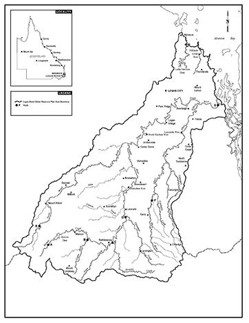
This plan applies to the area shown as the plan area on the map in schedule 1.See section 6 for information about the exact location of the plan area.
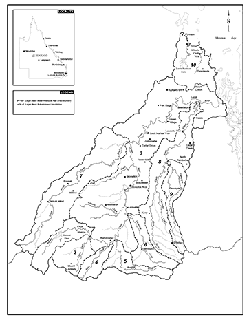
Each part of the plan area that is within a subcatchment area shown on the map in schedule 2, and named in schedule 3, is a subcatchment area for this plan.
(1)The exact location of the plan area and subcatchment area boundaries is held in digital electronic form by the department.(2)The information held in digital electronic form can be reduced or enlarged to show the details of the boundaries.
(1)A node mentioned in this plan is a place—(a)on a watercourse in the plan area; and(b)for which environmental flow objectives are set for performance indicators.(2)The location of each node is shown on the map in schedule 1 and described in schedule 4.(3)Each node is identified on the map by a letter of the alphabet.
This plan applies to the following water in the plan area—(a)water in a watercourse or lake;(b)water in springs not connected to water to which the Water Plan (Great Artesian Basin and Other Regional Aquifers) 2017 applies.s 8 amd 2016 SL No. 216 s 146 sch 20; 2017 SL No. 164 s 99
9Outcomes for water in the plan area
Water in the plan area is to be allocated and sustainably managed in a way that—(a)recognises the natural state of watercourses, lakes and springs has changed because of water infrastructure, flow supplementation and the taking of water; and(b)seeks to achieve a balance in the following outcomes—(i)the general outcomes mentioned in section 10;(ii)the ecological outcomes for particular parts of the plan area mentioned in section 11.
10General outcomes for the plan area
Each of the following is a general outcome for water in the plan area—(a)to provide for future water requirements, including the opportunity for additional water to be taken from the plan area;(b)to provide for the continued use of all water entitlements and other authorisations;(c)to protect the probability of being able to obtain water under a water allocation;(d)to encourage the efficient use of water;(e)to protect essential water supplies during times of low water availability;(f)to support natural ecosystems by minimising changes to natural flow regimes;(g)to allow water-related cultural use of parts of the plan area by the traditional owners of the parts of the area;(h)to provide consistency with the SEQ regional plan.
11Ecological outcomes for particular parts of the plan area
Each of the following is an ecological outcome for water in a particular part of the plan area—(a)for the Logan and Albert Rivers estuary—(i)to minimise changes to the delivery of fresh water, sediment, nutrients and organic matter to the estuary and southern Moreton Bay; and(ii)to minimise changes to the brackish water habitat in the estuary;(b)for Canungra Creek, Christmas Creek, Running Creek, Palen Creek and Upper Logan River subcatchment areas, Albert River and its tributaries upstream of node F, Burnett Creek and its tributaries upstream of node A and Teviot Brook and its tributaries upstream of node E—(i)to minimise changes to the low flow regime of the watercourses; and(ii)to minimise changes to the medium and high flow regime important to river forming processes;(c)for the Carbrook wetlands—to minimise changes to the flooding regime.
12Performance indicators for environmental flow objectives
The performance indicators for the environmental flow objectives are—(a)for assessing periods of low flow, the following—(i)50% daily flow;(ii)90% daily flow;(iii)daily flow less than 1ML;(iv)number of periods of no flow of at least 1 month but less than 3 months;(v)number of periods of no flow of at least 3 months but less than 6 months;(vi)number of periods of no flow of at least 6 months; and(b)for assessing periods of medium to high flow, the following—(i)mean annual flow;(ii)1.5 year daily flow volume;(iii)5 year daily flow volume;(iv)20 year daily flow volume; and(c)for assessing seasonal flow patterns—(i)flow regime class; and(ii)annual proportional flow deviation.
13Environmental flow objectives
The environmental flow objectives for this plan are stated in schedule 5.
14Performance indicators for water allocation security objectives
The performance indicators for the water allocation security objectives are—(a)for taking supplemented water—monthly supplemented water sharing index; and(b)for taking unsupplemented water—(i)for water allocations in a class A water allocation group—(A)mean unsupplemented water sharing index; and(B)95% unsupplemented water sharing index; and(ii)for water allocations in a class B, C or D water allocation group—(A)mean unsupplemented water sharing index; and(B)70% unsupplemented water sharing index.See section 59 for the water allocations in particular water allocation groups.
15Water allocation security objectives
The water allocation security objectives for this plan are stated in—(a)for water allocations to take supplemented water—schedule 6, part 1; and(b)for water allocations to take unsupplemented water—schedule 6, part 2.
16Application of div 1
This division applies to decisions about the allocation or management of water in the plan area, other than a decision—(a)about reinstating or replacing an expired water licence; or(b)to grant a water entitlement to a local government, government agency or the water grid manager for supply under operations that were in existence on the commencement of this plan.s 16 amd 2008 Act No. 34s 751sch 2
17Decisions consistent with objectives
Decisions about the allocation or management of water in the plan area, other than a decision about a water permit, must be consistent with—(a)the environmental flow objectives stated in schedule 5; and(b)the water allocation security objectives stated in schedule 6.
18Assessing impact of decisions
(1)The IQQM computer program’s simulation for the simulation period is used to assess consistency with the objectives.(2)If it is not practicable to use the IQQM computer program, another assessment method approved by the chief executive may be used.(3)The chief executive may approve an assessment method for subsection (2) only if the chief executive is satisfied the method will assess consistency with the objectives at least as accurately as the IQQM computer program.
19Decisions not to increase amount of water taken
(1)The chief executive must not make a decision that would increase the average volume of water allowed to be taken under authorisations in the plan area.(2)Subsection (1) does not apply to—(a)a decision about unallocated water made under section 22; or(b)a decision about a water permit.(3)A decision mentioned in subsection (1) includes a decision about an application for an authorisation to take water made but not dealt with before the commencement of this plan.s 19 amd 2008 Act No. 34s 751sch 2
20Restriction on taking water from waterholes or lakes
(1)The chief executive may grant a water licence, water permit or water allocation, or change the location from which water may be taken under a water allocation, to take water from a waterhole or lake only if—(a)the chief executive imposes a condition on the licence, permit or allocation about maintaining the cultural or environmental values of the waterhole or lake; or(b)the chief executive is satisfied the taking of the water will not adversely affect the cultural or environmental values of the waterhole or lake.a condition that the water may be taken only if the water level in the waterhole or lake is above the level that is 0.1m below the level at which the waterhole or lake naturally overflows(2)Subsection (1) does not apply to the grant of—(a)a water licence, water permit or water allocation to replace an authorisation in force immediately before the commencement of this plan; or(b)a water allocation converted from an authorisation in force immediately before the commencement.(3)In making a decision under subsection (1), the chief executive must consider—(a)the impact the proposed taking of the water may have on the following—(i)water quality;(ii)inundation of habitats;(iii)the movement of fish and other aquatic species;(iv)the natural movement of sediment;(v)recreation and aesthetic values;(vi)cultural values including, for example, the cultural values of the traditional owners of the area to which the application relates; and(b)whether the proposed taking is likely to have a direct adverse effect on groundwater flows.(4)Subsection (1) does not limit the restrictions that may be imposed on the taking of water from a waterhole or lake.(5)Subsection (3) does not limit the matters the chief executive may consider.
21Unallocated water held as general, strategic or town water supply reserve
Unallocated water is held as a general, strategic or town water supply reserve and dealt with under this division.
22Granting or reserving unallocated water
Unallocated water may be granted or reserved from the general, strategic or town water supply reserve under a process in the resource operations plan.
23Matters chief executive must consider
(1)In dealing with unallocated water, the chief executive must consider—(a)the need for, and efficiency of, present and proposed uses of water including—(i)the extent to which water is being taken under existing authorisations in the plan area; and(ii)emerging requirements for additional water, both within and outside the plan area, and the likely timeframe in which the additional water will be required; and(iii)alternative water sources including, for example, recycled water and water savings from improvements in the efficiency of water use; and(b)the availability of an alternative water supply for the purpose for which the water is required; and(c)the impact the proposed taking of, or interfering with, the water may have on the following—(i)water quality;(ii)estuarine areas;(iii)inundation of habitats;(iv)the movement of fish and other aquatic species;(v)the natural movement of sediment;(vi)recreation and aesthetic values;(vii)cultural values, including, for example, cultural values of the traditional owners of the area; and(d)whether the proposed taking of or interfering with, or the proposed use of, the water is likely to—(i)have a direct adverse effect on groundwater; or(ii)lead to degradation of land or downstream watercourses; and(e)whether the proposed use of the water is consistent with—(i)the SEQ regional plan; and(ii)a system operating plan applying to the plan area; and(iii)a regional water security program for the SEQ region; and(f)if the process in the resource operations plan for granting unallocated water includes a public auction, public ballot or public tender—the price offered under the process.(2)Subsection (1) does not limit the matters the chief executive may consider.
24Application of sdiv 2
This subdivision applies to unallocated water that is held as a general reserve.
25Granting or reserving unallocated water from the general reserve
(1)Unallocated water may be granted or reserved from the general reserve under a water entitlement to take unsupplemented water.(2)Each water entitlement must state, for the entitlement, the following—(a)the purpose for which the water may be taken;(b)the annual volumetric limit;(c)the maximum rate at which the water may be taken;(d)the flow conditions under which the water may be taken.
26Application of sdiv 3
This subdivision applies to unallocated water that is held as a strategic reserve.
27Granting or reserving unallocated water from the strategic reserve
Unallocated water may be granted or reserved from the strategic reserve only—(a)for infrastructure for a project declared under the State Development and Public Works Organisation Act 1971, section 26, to be a significant project; or(b)for infrastructure identified in—(i)the SEQ regional plan or instruments that implement the plan; or(ii)a regional water security program for the SEQ region.
28Application of sdiv 4
This subdivision applies to unallocated water that is held as a town water supply reserve.
29Granting unallocated water from the town water supply reserve
Unallocated water may be granted from the town water supply reserve under a water licence for the water grid manager to take an annual volumetric limit of up to 150ML from Canungra Creek.s 29 amd 2008 Act No 34 s 751sch 2
pt 5 div 3 hdg om 2014 SL No. 142s 130
pt 5 div 3 sdiv 1 hdg om 2014 SL No. 142s 130
s 30 om 2014 SL No. 142s 130
pt 5 div 3 sdiv 2 om 2014 SL No. 142s 130
s 31 om 2014 SL No. 142s 130
s 32 om 2014 SL No. 142s 130
s 33 om 2014 SL No. 142s 130
s 34 om 2014 SL No. 142s 130
pt 5 div 3 sdiv 3 hdg om 2014 SL No. 142s 130
s 35 om 2014 SL No. 142s 130
s 36 om 2014 SL No. 142s 130
s 37 om 2014 SL No. 142s 130
pt 5 div 3 sdiv 4 hdg om 2014 SL No. 142s 130
s 38 om 2014 SL No. 142s 130
s 39 om 2014 SL No. 142s 130
s 40 om 2014 SL No. 142s 130
s 41 om 2014 SL No. 142s 130
pt 5 div 3 sdiv 5 hdg om 2014 SL No. 142s 130
s 42 om 2014 SL No. 142s 130
pt 5 div 4 hdg sub 2014 SL No. 142s 131
s 43 amd 2008 Act No. 34s 751sch 2
om 2014 SL No. 142s 132
44Matters chief executive must consider
(1)In deciding the operating arrangements and supply requirements for water infrastructure, the chief executive must consider—(a)the impact of the infrastructure’s operation on the following—(i)water quality;(ii)instream water levels;(iii)erosion of the bed and banks of watercourses;(iv)riparian vegetation;(v)the extent to which artificial variations in instream water levels and flows may adversely affect natural ecosystems;(vi)recreation and aesthetic values;(vii)cultural values, including, for example, cultural values of the traditional owners of the area; and(b)the impact of the infrastructure on the movement of fish and other aquatic species; and(c)the impact on natural ecosystems of the transfer of water between watercourses; and(d)the likelihood of fish deaths caused by the operation of the infrastructure; and(e)the joint operation of all the infrastructure; and(f)any system operating plan applying to the plan area; and(g)any regional water security program for the SEQ region.(2)Subsection (1) does not limit the matters the chief executive may consider.s 44 amd 2014 SL No. 142s 133
46Definition for div 6
In this division—authorisation means an authorisation or authority mentioned in section 47.
47Application of div 6
This division applies only to—(a)authorisations converted, under the resource operations plan, to water allocations; and(b)water allocations converted, under the resource operations plan, from authorisations.s 47 amd 2014 SL No. 142s 135
The location for taking water stated on a water allocation must include the place at which water could have been taken under the authorisation.
49Purpose to be stated on water allocation
The purpose stated on a water allocation must be ‘any’.
pt 5 div 6 sdiv 2 hdg om 2014 SL No. 142s 136
s 50 om 2014 SL No. 142s 136
s 51 om 2014 SL No. 142s 136
s 52 om 2014 SL No. 142s 136
53Elements of a water allocation to take unsupplemented water
A water allocation to take unsupplemented water must state—(a)the maximum rate at which water may be taken under the allocation; and(b)the annual volumetric limit for the allocation.s 53 sub 2014 SL No. 142s 137
54Nominal volumes for water allocations to take unsupplemented water
(1)The nominal volume for a water allocation in a water allocation group mentioned in schedule 8, column 1, is the volume decided by the chief executive.(2)In deciding the nominal volume, the chief executive—(a)must have regard to—(i)the local availability of water; and(ii)the conditions under which water may be taken under the authorisation; and(iii)the annual volumes of water estimated by the chief executive to have been taken under the authorisation during the period, of not more than 10 years, immediately before the commencement of this plan; and(iv)the simulated mean annual diversion for the authorisation; and(v)the efficiency of the use of the water mentioned in subparagraph (iii); and(b)must ensure the total of the nominal volumes for the water allocations in the water allocation group is not more than the volume stated in schedule 8, column 2, for the group.
55Annual volumetric limit for taking unsupplemented water
(1)The annual volumetric limit for a water allocation to take unsupplemented water is—(a)for an authorisation that states the volume of water that may be taken in a period of 12 months—the volume stated on the authorisation; and(b)for an authorisation that states the area that may be irrigated—the volume decided by the chief executive having regard to the volume of water required to efficiently irrigate the area, but not more than the volume, expressed in megalitres, calculated by multiplying the area, in hectares, by 6; and(c)for another authorisation—the volume decided by the chief executive having regard to—(i)the conditions under which water may be taken under the authorisation; and(ii)the water taking capacity of any works, being used or authorised to be used, for taking water under the authorisation; and(iii)the annual volumes of water estimated by the chief executive to have been taken under the authorisation during the period, of not more than 10 years, immediately before the commencement of this plan; and(iv)the efficiency of the use of the water mentioned in subparagraph (iii).(2)Subsection (1)(c) does not limit the matters the chief executive may consider.
s 56 om 2014 SL No. 142s 138
57Maximum rates for taking unsupplemented water
The maximum rate at which unsupplemented water may be taken under a water allocation is—(a)for an authorisation that states a maximum rate—the rate stated on the authorisation; and(b)for an authorisation that does not state a maximum rate but for which a related development permit states a pump size mentioned in schedule 9, column 1—(i)if the authorisation holder satisfies the chief executive that the actual rate at which water can be taken is different from the rate stated in schedule 9, column 2, for the pump size—the rate decided by the chief executive having regard to—(A)the conditions under which water may be taken under the authorisation; and(B)the water taking capacity of the pump to which the development permit relates (the existing pump) under normal operating conditions; and(C)the irrigation or water distribution system related to the existing pump during the period of not more than 10 years immediately before the commencement of this plan; and(D)the efficiency of the water use mentioned in subsubparagraph (C); or(ii)otherwise—the rate stated in schedule 9, column 2, for the pump size; and(c)for an authorisation that does not state a maximum rate but for which a related development permit states a pump size other than a pump size mentioned in schedule 9, column 1—the rate decided by the chief executive having regard to the matters mentioned in paragraph (b)(i)(A) to (D); and(d)for another authorisation—the rate decided by the chief executive having regard to—(i)the nature of the authorisation; and(ii)an estimate of the rate, or measurement of the actual rate, at which water is taken under the authorisation.
58Conditions for water allocations to take unsupplemented water
In deciding the conditions under which water may be taken under a water allocation to take unsupplemented water, the chief executive must have regard to the conditions stated on the relevant authorisation.
59Water allocation groups for water allocations to take unsupplemented water
A water allocation to take unsupplemented water in a subcatchment area mentioned in schedule 10, column 1, belongs to—(a)for an authorisation for town water supply purposes—the water allocation group (class A) mentioned opposite the subcatchment area in schedule 10, column 2; and(b)for an authorisation that states the area that may be irrigated or the volume of water that may be taken in a period of 12 months, other than an authorisation for town water supply purposes or stock or domestic purposes—the water allocation group (class B) mentioned opposite the subcatchment area in schedule 10, column 3; and(c)for other authorisations to take unsupplemented water in the area of the Logan River Water Supply Scheme—the water allocation group (class C) mentioned opposite the subcatchment area in schedule 10, column 4; and(d)for other authorisations—the water allocation group (class D) mentioned opposite the subcatchment area in schedule 10, column 5.
60Amending water licences to take unsupplemented water
(1)This section applies to a water licence to take unsupplemented water in force on the commencement of this plan.(2)The licence may be amended under a process in the resource operations plan to state the following—(a)the purpose for which water may be taken under the licence;(b)the annual volumetric limit for the licence;(c)the maximum rate at which water may be taken under the licence;(d)the flow conditions for the licence.s 60 amd 2014 SL No. 142s 139
61Annual volumetric limit for taking unsupplemented water
The annual volumetric limit to take unsupplemented water for a water licence mentioned in section 60 is the annual volumetric limit mentioned in section 55 or decided by the chief executive under that section as if the water licence were a water allocation.s 61 sub 2014 SL No. 142s 140
62Maximum rates for taking unsupplemented water
The maximum rate at which unsupplemented water may be taken under a water licence mentioned in section 60 is the maximum rate mentioned in section 57 or decided by the chief executive under that section as if the water licence were a water allocation.s 62 sub 2014 SL No. 142s 140
65Releasing water through fish ways
If water to which this plan applies can be released from a dam or weir through fish ways, the environmental management rules in the resource operations plan must provide for the release.
s 66 om 2014 SL No. 142s 142
pt 6 hdg sub 2014 SL No. 142s 143
67Monitoring and reporting requirements
(1)To help the Minister assess the effectiveness of the management strategies for achieving the outcomes mentioned in part 3, the resource operations plan must state—(a)the monitoring requirements for water and natural ecosystems for this plan; and(b)the reporting requirements for this plan for operators of infrastructure interfering with water in the plan area.(2)Also, a monitoring requirement for this plan is to monitor groundwater levels in the plan area.(3)Subsections (1) and (2) do not limit the monitoring requirements the chief executive may impose for this plan.s 67 sub 2014 SL No. 142s 143
s 68 sub 2014 SL No. 142s 143
om 2016 SL No. 216 s 146 sch 20
s 69 om 2014 SL No. 142s 143
s 70 om 2014 SL No. 142s 143
71Priorities for converting to, or granting, water allocations
Each area described in schedule 11 is a priority area for this plan for the conversion to, or granting of, water allocations.
s 72 amd 2008 Act No. 34s 751sch 2
om 2014 SL No. 142s 144
73Minor or stated amendment of plan—Act, s 57
The following types of amendment may be made to this plan under section 57(b) of the Act—(a)an amendment or addition of an environmental flow objective if the amendment or addition achieves an equivalent or improved ecological outcome without adversely affecting the water allocation security objectives or the outcomes under part 3;(b)an amendment or addition of a water allocation security objective if the amendment or addition does not adversely affect existing water allocations, environmental flow objectives or the outcomes under part 3;(c)an amendment or addition of a priority area;(d)an amendment or addition of a node;(e)an amendment or addition of a priority group;(f)an amendment or addition of a water allocation group;(g)an amendment to subdivide a subcatchment area or amalgamate subcatchment areas;(h)an amendment to subdivide a volume, or amalgamate volumes, stated in schedule 8;(i)an amendment or addition of a monitoring or reporting requirement under part 6.
The Minister must consider amending this plan or preparing a new plan to replace this plan if the Minister is satisfied—(a)in relation to this plan’s outcomes under part 3—(i)water entitlements in the plan area are not sufficient to meet water needs sourced from the plan area having regard to—(A)the extent to which water is being taken under the water entitlements; and(B)the efficiency of present, and expected future, water use; and(C)emerging requirements for additional water; and(D)alternative water sources including, for example, recycled water and water savings from improvements in the efficiency of water use; and(E)the likely timeframe in which additional water will be required; and(ii)there are economically viable and ecologically sustainable uses for additional water; or(b)this plan’s ecological outcomes under section 10 or 11 are not being achieved; or(c)this plan is inconsistent with the SEQ regional plan.
Column 1 | Column 2 |
Subcatchment area | Subcatchment area name |
1 | Burnett Creek |
2 | Upper Logan River |
3 | Logan River |
4 | Palen Creek |
5 | Running Creek |
6 | Christmas Creek |
7 | Teviot Brook |
8 | Albert River |
9 | Canungra Creek |
10 | Redlands subcatchments |
Column 1 | Column 2 |
Node | Location |
A | Burnett Creek upstream of Maroon Dam at AMTD 32.6km |
B | Logan River at Foresthome AMTD 166.4km |
C | Running Creek at AMTD 0.0km |
D | Christmas Creek at AMTD 0.0km |
E | Teviot Brook at Croftby AMTD 82.3km |
F | Albert River at Lumeah AMTD 75.5km |
G | Logan River at AMTD 0.0km |
Column 1 Column 2 Node 50% daily flow in megalitres Feb–April water flow season May–July water flow season Aug–Nov water flow season Dec–Jan water flow season A 21 12 7 9 B 40 21 10 26 C 77 48 29 37 D 59 42 28 33 E 9 6 3 5 F 72 43 26 37 G 585 318 185 3271At each node mentioned in table 1, column 1, the 50% daily flow for the pre-development flow pattern for a water flow season is stated in column 2 of the table.
Table 1
2At each node mentioned in table 2, column 1, the percentage of the total number of days in a water flow season in the simulation period that the 50% daily flow for the plan scenario flow pattern stated for the water flow season in table 1 is equalled or exceeded be at least the percentage stated in column 2 of the table for the water flow season.Table 2
Column 1
Column 2
Node
Feb–April water flow season
May–July water flow season
Aug–Nov water flow season
Dec–Jan water flow season
A
41
41
43
41
B
41
40
42
40
C
35
34
23
32
D
35
34
19
19
E
42
43
37
41
F
35
34
27
32
G
30
25
13
21
3At each node mentioned in table 3, column 1, the 90% daily flow for the pre-development flow pattern for a water flow season is stated in column 2 of the table.Table 3
Column 1
Column 2
Node
90% daily flow in megalitres
Feb–April water flow season
May–July water flow season
Aug–Nov water flow season
Dec–Jan water flow season
A
1
1
0
0
B
2
2
0
1
C
17
18
11
9
D
12
12
7
5
E
0
1
0
0
F
14
15
7
6
G
110
108
47
54
4At each node mentioned in table 4, column 1, the percentage of the total number of days in a water flow season in the simulation period that the 90% daily flow for the plan scenario flow pattern stated for the water flow season in table 3 is equalled or exceeded be at least the percentage stated in column 2 of the table for the water flow season.Table 4
Column 1
Column 2
Node
Feb–April water flow season
May–July water flow season
Aug–Nov water flow season
Dec–Jan water flow season
A
80
83
81
80
B
80
78
77
81
C
70
66
35
43
D
51
57
27
25
E
79
76
60
58
F
71
71
41
45
G
53
38
29
44
5At each node mentioned in table 5, column 1, the percentage of the total number of days in the simulation period on which the daily flow is less than 1ML be between the minimum and maximum percentages stated for the node in column 2 of the table.Table 5
Column 1
Column 2
Node
Minimum-maximum percentage
A
11–19
B
8–26
C
0–2
D
0–4
E
14–55
F
7–61
G
0–24
6At each node mentioned in table 6, column 1, minimise the extent to which—At each node mentioned in table 7, column 1—(a)the number of periods of no flow of at least 1 month but less than 3 months in the simulation period is less than the minimum or more than the maximum number stated for the node in column 2 of the table; and(b)the number of periods of no flow of at least 3 months but less than 6 months in the simulation period is less than the minimum or more than the maximum number stated for the node in column 3 of the table; and(c)the number of periods of no flow of at least 6 months in the simulation period is less than the minimum or more than the maximum number stated for the node in column 4 of the table.Table 6
Column 1
Column 2
Column 3
Column 4
Node
Minimum-maximum
Minimum-maximum
Minimum-maximum
A
6–26
0–3
0–0
B
8–45
1–12
0–0
C
0–2
—
—
D
0–4
—
—
E
12–73
1–29
0–6
F
0–127
0–38
0–11
G
0–17
0–2
0–0
(a)the mean annual flow, expressed as a percentage of the mean annual flow for the pre-development flow pattern, be at least the percentage stated for the node in column 2 of the table; and
(b)the 1.5 year daily flow volume, expressed as a percentage of the 1.5 year daily flow volume for the pre-development flow pattern, be at least the percentage stated for the node in column 3 of the table; and
(c)the 5 year daily flow volume, expressed as a percentage of the 5 year daily flow volume for the pre-development flow pattern, be at least the percentage stated for the node in column 4 of the table; and
(d)the 20 year daily flow volume, expressed as a percentage of the 20 year daily flow volume for the pre-development flow pattern, be at least the percentage stated for the node in column 5 of the table.
Table 7
Column 1 | Column 2 | Column 3 | Column 4 | Column 5 |
Node | Mean annual flow percentage | 1.5 year daily flow volume percentage | 5 year daily flow volume percentage | 20 year daily flow volume percentage |
A | 99 | 99 | — | — |
B | 99 | 99 | — | — |
C | 88 | 99 | — | — |
D | 82 | 98 | — | — |
E | 95 | 99 | — | — |
F | 90 | 97 | — | — |
G | 76 | 80 | 83 | 86 |
(a)the annual proportional flow deviation be no greater than the annual proportional flow deviation stated for the node in column 2 of the table; and
(b)the flow regime class be maintained as late summer flow regime class.
Table 8
Column 1 | Column 2 |
Node | Annual proportional flow deviation |
C | 1.2 |
D | 1.2 |
G | 1.5 |
sch 5 sub 2014 SL No. 142 s 145
1For water allocations in a high priority group in the Logan River Water Supply Scheme—
(a)the monthly supplemented water sharing index be at least 95%; and
(b)the extent to which it is less than 99% be minimised.
2For water allocations in a medium priority group in the Logan River Water Supply Scheme—
(a)the monthly supplemented water sharing index be at least 80%; and
(b)the extent to which it is less than 85% be minimised.
Column 1 Column 2 Column 3 Column 4 Water allocation group Mean unsupplemented water sharing index—volume in megalitres 70% unsupplemented water sharing index— percentage 95% unsupplemented water sharing index— percentage 8A 982 — 56 9A 285 — 99 1B 30 81 — 2B 156 83 — 3B 2,057 85 — 4B 417 79 — 5B 4,540 94 — 6B 6,241 90 — 7B 1,893 87 — 8B 9,192 83 — 9B 4,299 86 — 1C 23 — — 3C 6,037 86 — 3D 486 87 — 4D 43 49 — 5D 129 89 — 6D 136 86 — 7D 1,176 81 — 8D 4,487 84 — 9D 2,036 81 —1For water allocations in a water allocation group mentioned in table 1, column 1—
(a)the mean unsupplemented water sharing index be at least the volume stated, for the group, in table 1, column 2; and
(b)the extent to which the 70% unsupplemented water sharing index is less than the percentage stated, for the group, in table 1, column 3, be minimised; and
(c)the 95% unsupplemented water sharing index be at least the percentage stated, for the group, in table 1, column 4.
Table 1
sch 7 sub 2007 SL No. 242s 3
om 2008 Act No. 34 s 751sch 2
Column 1 | Column 2 |
Water allocation group | Volume in megalitres |
8A | 982 |
9A | 285 |
1B | 30 |
2B | 156 |
3B | 2,057 |
4B | 417 |
5B | 4,540 |
6B | 6,241 |
7B | 2,329 |
8B | 9,192 |
9B | 4,299 |
1C | 23 |
3C | 6,037 |
3D | 486 |
4D | 43 |
5D | 129 |
6D | 136 |
7D | 1,405 |
8D | 4,487 |
9D | 2,036 |
sections 57 and 62
Column 1 | Column 2 |
Pump size (mm) | Rate (litres/second) |
32 | 8 |
40 | 13 |
50 | 25 |
65 | 46 |
80 | 50 |
100 | 85 |
125 | 120 |
150 | 150 |
200 | 190 |
250 | 220 |
300 | 300 |
350 | 350 |
400 | 440 |
Column 1 | Column 2 | Column 3 | Column 4 | Column 5 |
Subcatchment area | Water allocation group (class A) | Water allocation group (class B) | Water allocation group (class C) | Water allocation group (class D) |
1 | — | 1B | 1C | 1D |
2 | — | 2B | — | — |
3 | — | 3B | 3C | 3D |
4 | — | 4B | — | 4D |
5 | — | 5B | — | 5D |
6 | — | 6B | — | 6D |
7 | — | 7B | — | 7D |
8 | 8A | 8B | — | 8D |
9 | 9A | 9B | — | 9D |
Priority area 1 is the area of the Logan River Water Supply Scheme which consists of—(a)the part of Burnett Creek downstream of Maroon Dam including the ponded area of the dam; and(b)the part of the Logan River from its confluence with Burnett Creek to AMTD 65km.
Priority area 2 consists of—(a)Running Creek subcatchment area consisting of Running Creek and all its tributaries; and(b)Christmas Creek subcatchment area consisting of Christmas Creek and all its tributaries.
sch 13, definition annual proportional flow deviation
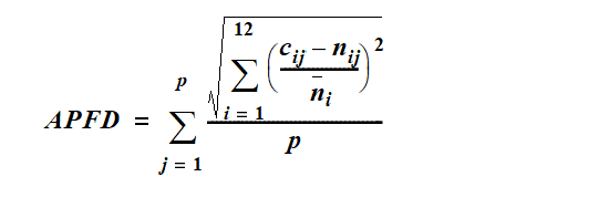
p means the number of years.
cij means the modelled flow for month i in year j.
nij means the modelled natural flow for month i in year j.
ni means the modelled natural flow for month i across p years.
1.5 year daily flow volume, for a node, means the daily flow, at the node, that has a 67% probability of being reached at least once a year.
5 year daily flow volume, for a node, means the daily flow, at the node, that has a 20% probability of being reached at least once a year.
20 year daily flow volume, for a node, means the daily flow, at the node, that has a 5% probability of being reached at least once a year.
50% daily flow, for a month for a node, means the daily flow, at the node, that is equalled or exceeded on 50% of days in the month in the simulation period.
70% unsupplemented water sharing index, for a group of water allocations, means the average total volume of water simulated to have been taken annually under the allocations in at least 70% of years in the simulation period, if the allocations were in existence for the whole of the simulation period, expressed as a percentage of the simulated mean annual diversion for the allocations.
90% daily flow, for a month for a node, means the daily flow, at the node, that is equalled or exceeded on 90% of days in the month in the simulation period.
95% unsupplemented water sharing index, for a group of water allocations, means the average total volume of water simulated to have been taken annually under the allocations in at least 95% of years in the simulation period, if the allocations were in existence for the whole of the simulation period, expressed as a percentage of the simulated mean annual diversion for the allocations.
adopted middle thread distance means the distance in kilometres, measured along the middle of a watercourse, that a specific point in the watercourse is, at the commencement of this plan, from—
(a)the watercourse’s mouth; or
(b)if the watercourse is not a main watercourse—the watercourse’s confluence with its main watercourse.
AMTD means adopted middle thread distance.
annual proportional flow deviation, for a node, means the statistical measure of changes to flow season and volume in the simulation period, at the node, calculated using the formula in schedule 12.
annual variability, for a flow at a point in a watercourse, means the amount of change in the flow that happens between years.
annual volumetric limit, for a water entitlement, means the maximum volume of water that may be taken under the entitlement in a period of 12 months.
authorisation means a water licence, water permit, interim water allocation or other authority to take water given under the Act or the repealed Act, other than a permit for stock or domestic purposes.
average volume of water allowed to be taken under authorisations means the total volume of water simulated to have been taken under the authorisations during the simulation period if the authorisations were in existence for the whole of the simulation period, divided by the number of years in the simulation period.
critical water supply strategy ...
sch 13 def critical water supply strategy om 2014 SL No. 142 s 146(1)
daily flow, for a node, means the volume of water that flows past the node in a day.
daily volumetric limit ...
sch 13 def daily volumetric limit om 2014 SL No. 142 s 146(1)
discharge, for a flow at a point in a watercourse, means the rate at which water passes the point, measured in cubic metres a second or megalitres a day.
ecological assets include a species, a group of species, a biological function, an ecosystem and a place of natural value.
event duration, for a flow at a point in a watercourse, means the period of time when the discharge is greater than or less than the level necessary for a particular ecological process to happen.
flow regime means the entire range of flows at a point in a watercourse including variations in the watercourse height, discharge, seasonality, annual variability and event duration.
flow regime class means the measure of flow regime seasonality worked out using the method stated in Haines, A.T., Finlayson, B.L. and McMahon, T.A., ‘A global classification of river regimes. Applied Geography, 1988’.
groundwater means water from an underground source.
high priority group, for a water allocation, means a water allocation that is stated to be a high priority in the water allocations register.
sch 13 def high priority group ins 2014 SL No. 142 s 146(2)
hydraulic habitat requirements, of an ecological asset, are the hydraulic or physical attributes of the flow regime that are—
(a)required for a particular biological process or response to happen in relation to the asset; or
(b)necessary to maintain the long-term biological integrity of the asset.
infrastructure operating rules means, for infrastructure to which the resource operations plan applies, the infrastructure operating rules included in the resource operations plan.
IQQM computer program means the department’s Integrated Quantity and Quality Modelling computer program, and associated statistical analysis and reporting programs, that simulate daily stream flows, flow management, storages, releases, instream infrastructure, water diversions, water demands and other hydrologic events in the plan area.
mean annual flow, for a node, means the total volume of flow, at the node, in the simulation period divided by the number of years in the simulation period.
mean unsupplemented water sharing index, for a group of water allocations, means the average total volume of water simulated to have been taken annually under the allocations in the simulation period, if the allocations were in existence for the whole of the simulation period.
medium priority group, for a water allocation, means a water allocation that is stated to be a medium priority in the water allocations register.
sch 13 def medium priority group ins 2014 SL No. 142 s 146(2)
monthly supplemented water sharing index, for water allocations in a water supply scheme, means the percentage of months in the simulation period in which the allocations are fully supplied.
monthly volumetric limit ...
sch 13 def monthly volumetric limit om 2014 SL No. 142 s 146(1)
node see section 7.
period of no flow, for a node, means a period in which the flow of water in the watercourse at the node is less than 1ML a day.
plan area means the area shown as the plan area on the map in schedule 1.
plan scenario flow pattern means the pattern of water flows, during the simulation period, decided by the chief executive using the IQQM computer program as if—
(a)all unallocated water in the strategic reserve and general reserve is being taken; and
(b)the maximum volume allowed to be taken under each authorisation in the plan area is being taken.
pre-development flow pattern means the pattern of water flows, during the simulation period, decided by the chief executive using the IQQM computer program as if—
(a)there were no dams or other water infrastructure in the plan area; and
(b)no water was taken under authorisations in the plan area.
priority area see section 71.
related development permit, for an authorisation, means the development permit for the works for taking water under the authorisation.
resource operations plan means the resource operations plan to implement this plan.
See the Act, section 1266.
sch 13 def resource operations plan amd 2016 SL No. 216 s 146 sch 20
seasonality, for a flow at a point in a watercourse, means the time of year when the flow happens.
SEQ region ...
sch 13 def SEQ region sub 2009 SL No. 280 s 183
om 2017 SL No. 103 s 160(1)
SEQ regional plan means the regional plan under the Planning Act for the region named the SEQ region under the Planning Regulation 2017.
sch 13 def SEQ regional plan sub 2009 SL No. 280 s 183; 2017 SL No. 103 s 160
simulated mean annual diversion, for an authorisation or group of authorisations, means the total volume of water simulated to have been taken under the authorisations, if the authorisations were in existence for the whole of the simulation period, divided by the number of years in the simulation period.
simulation period means the period from 1 January 1890 to 30 June 2003.
subcatchment area see section 5.
supplemented water means water supplied under a resource operations licence or other authority to operate water infrastructure.
sch 13 def supplemented water amd 2014 SL No. 142 s 146(3)
this plan means this water resource plan.
traditional owners, of an area, means the Aboriginal people who identify as descendants of the original inhabitants of the area.
unsupplemented water means water that is not supplemented water.
water flow season means any of the following periods in a year—
(a)the period from 1 February to 30 April (Feb–April water flow season);
(b)the period from 1 May to 31 July (May–July water flow season);
(c)the period from 1 August to 30 November (Aug–Nov water flow season);
(d)the period from 1 December to 31 January (Dec–Jan water flow season).
sch 13 def water flow season ins 2014 SL No. 142 s 146(2)
water supply scheme means the Logan River Water Supply Scheme described in schedule 11.