


This water plan may be cited as the Water Plan (Baffle Creek Basin) 2010.s 1 sub 2014 Act No. 64 s 255 sch 2
The following are the purposes of this plan—(a)to define the availability of water in the plan area;(b)to provide a framework for sustainably managing water and the taking of water;(c)to identify priorities and mechanisms for dealing with future water requirements;(d)to provide a framework for minimising, where practicable, degradation in natural ecosystems;(e)to regulate the taking of overland flow water.
The dictionary in schedule 9 defines particular words used in this plan.
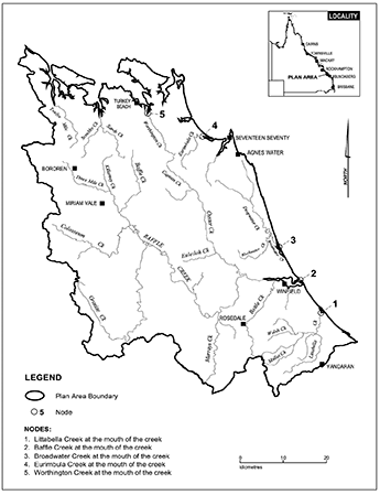
This plan applies to the area shown as the plan area on the map in schedule 1.
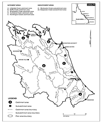
Each part of the plan area that is within a catchment area shown on the map in schedule 2 is a catchment area for this plan.
Each part of the plan area that is within a subcatchment area shown on the map in schedule 2 is a subcatchment area for this plan.
(1)The exact location of the boundaries of the plan area, catchment areas and subcatchment areas is held in digital electronic form by the department.(2)The information held in digital electronic form can be reduced or enlarged to show the details of the boundaries.
(1)A node mentioned in this plan is a place on a watercourse in the plan area.(2)The location of each node is shown on the map in schedule 1 and described in schedule 3.(3)Each node is identified on the map by a number.
This plan applies to the following water in the plan area—(a)water in a watercourse, lake or spring;(b)overland flow water.s 9 sub 2016 SL No. 216 s 146 sch 20
10Outcomes for water in plan area
Water is to be allocated and sustainably managed in a way that—(a)recognises the natural state of watercourses, lakes and springs has changed because of the taking of, and interfering with, water; and(b)seeks to achieve a balance in the following outcomes—(i)the general outcomes mentioned in section 11;(ii)the ecological outcomes for the plan area mentioned in section 12 or 13.
Each of the following is a general outcome for water in the plan area—(a)to provide for the use of all existing water entitlements and other authorisations to take or interfere with water;(b)to provide for the continued use of all existing overland flow works;(c)to make water available to support—(i)population growth in towns and communities dependent on surface water resources in the plan area; and(ii)growth in industries, including agriculture and aquaculture, dependent on surface water resources in the plan area; and(iii)stock or domestic purposes in the plan area;(d)to maintain flows that support water related aesthetic, economic and recreational values in the plan area, including, for example, tourism;(e)to support, as far as practicable, surface water and groundwater interactions;(f)to encourage continual improvement in the efficient use of water;(g)to support water-related cultural values in the plan area, including the values of the traditional owners of the plan area.
(1)Each of the following is an ecological outcome for water in the plan area—(a)to minimise changes to the natural variability of flows that support aquatic ecosystems;(b)to provide for the continued capability of one part of an aquatic system to be connected to another, including by maintaining flows that—(i)allow for the movement of native aquatic species between riverine, floodplain, wetland, estuarine and marine environments; and(ii)support natural processes such as breeding, growth and migration in riverine, floodplain, wetland, estuarine and marine environments; and(iii)support river-forming processes;(c)to minimise changes to natural variability in water levels to support natural ecological processes, including maintaining refugia associated with waterholes and lakes;(d)to minimise adverse impacts on aquatic ecosystems immediately downstream of new water resource development;(e)to improve understanding of the matters affecting flow ecology responses of ecosystems within the plan area.(2)In this section—refugia means the habitat required by a species during a time of stress, for example, drought.
13Specific ecological outcomes
Each of the following is a specific ecological outcome for water in the plan area—(a)to maintain the near-natural flow regime that supports waterholes and estuarine ecosystems in the Eurimbula Creek catchment area and Worthington Creek catchment area;(b)to minimise changes to flows that maintain existing brackish habitat downstream of barrages in the Broadwater Creek catchment area;(c)in the Baffle Creek catchment area—(i)to maintain connectivity between Baffle Creek and its adjacent floodplain system including lakes; and(ii)to maintain the near-natural flow regime that provides for intermittent brackish habitat through the entire length of the Baffle Creek estuary; and(iii)to minimise changes to the low flow regime that provides for riffle habitat and maintains waterholes; and(iv)to minimise changes to the persistence of waterholes;(d)to minimise changes to the flow regime that maintains brackish habitat in the upper reaches of Littabella Creek estuary.
14Performance indicators for environmental flow objectives
The performance indicators for the environmental flow objectives are the following—(a)mean annual flow;(b)median annual flow.
15Environmental flow objectives
The environmental flow objectives for this plan are stated in schedule 4.
16Decisions to be consistent with environmental flow objectives
Decisions about the allocation or management of water in the plan area, other than a decision about a water permit, must be consistent with the environmental flow objectives stated in schedule 4.
17Assessing impact of decisions
(1)The IQQM computer program’s simulation for the simulation period is used to assess consistency with the objectives.(2)If it is not practicable to use the IQQM computer program, another assessment method approved by the chief executive may be used.(3)The chief executive may approve an assessment method for subsection (2) only if the chief executive is satisfied the method will assess consistency with the objectives at least as accurately as the IQQM computer program.
18Decisions are not to increase amount of water taken
(1)The chief executive is not to make a decision about the allocation or management of water in the plan area that would increase the average volume of water allowed to be taken under any authorisation in the plan area.(2)Subsection (1) does not apply to a decision about—(a)a water permit; or(b)reinstating an expired water licence; or(c)replacing an original licence if the licence is to be replaced with 2 or more water licences; or(d)replacing an expired licence with 1 or more licences; or(e)unallocated water.(3)In this section—average volume, of water allowed to be taken under an authorisation, means the total volume of water simulated to have been taken under the authorisation during the simulation period if the authorisation was in existence for the whole of the simulation period, divided by the number of years in the simulation period.s 18 amd 2014 SL No. 142s 3
s 19 om 2014 SL No. 142s 4
ch 5 pt 2 div 2 hdg om 2014 SL No. 142s 5
s 20 om 2014 SL No. 142s 5
s 21 om 2014 SL No. 142s 5
s 22 om 2014 SL No. 142s 5
23Unallocated water held as strategic reserve and general reserve
Unallocated water in the plan area is divided into a strategic reserve and a general reserve.
24Purpose for which unallocated water held as strategic reserve may be granted
Unallocated water held as a strategic reserve may be granted only if the water is to be taken for a State purpose.
The total of the nominal entitlements for all water licences to take unallocated water granted from the strategic reserve in a catchment area mentioned in schedule 5, part 1, column 1 is stated in schedule 5, part 1, column 2 opposite the area.
26Period for which water is granted for particular State purpose
(1)This section applies to the volume of water granted from the strategic reserve for either of the following State purposes—(a)a project of State significance;(b)a project of regional significance.(2)The volume of water is granted only for the life of the project and on conclusion of the project the volume of water returns to the strategic reserve.
27Projects that may be considered to be of regional significance
The chief executive may consider a particular project to be a project of regional significance for the plan area only if the chief executive considers the project is significant for a region in the plan area having regard to the following—(a)the outcomes under chapter 3;(b)the economic or social impact the project will have on the region;(c)the public interest and the welfare of people in the region;(d)any other relevant consideration.
28Purpose for which unallocated water held as general reserve may be granted
Unallocated water held as a general reserve may be granted for any purpose.
The total of the nominal entitlements for all water licences to take unallocated water granted from the general reserve in a catchment area mentioned in schedule 5, part 2, column 1 is stated in schedule 5, part 2, column 2 opposite the area.
30Restrictions on taking water from lakes
A water licence to take unallocated water, granted from either the strategic or general reserve, must not authorise the taking of water from a lake.
31Pass flow conditions for taking unallocated water
(1)Water licences to take water from a watercourse granted from the strategic or general reserve must include a pass flow condition.(2)In deciding the pass flow condition, the chief executive must consider—(a)existing downstream entitlement holders; and(b)the daily volumetric limit to be stated on the licence.(3)The pass flow condition must be at least—(a)for the Baffle Creek catchment area, the greater of the following—(i)the flow, expressed in megalitres a day, worked out by multiplying the catchment area upstream of the proposed point of take, expressed in square kilometres, by 0.3561;(ii)86.4ML a day; or(b)for the Littabella Creek catchment area, the greater of the following—(i)the flow, expressed in megalitres a day, worked out by multiplying the catchment area upstream of the proposed point of take, expressed in square kilometres, by 1;(ii)43ML a day; or(c)for the Broadwater Creek, Eurimbula Creek or Worthington Creek catchment area—86.4ML a day.(4)This section does not apply to a water licence to take water from an impoundment.(5)In this section—pass flow condition means a condition on a water licence to take water that states the rate of flow in a watercourse that must, while water is being taken under the licence, be passing immediately downstream of the point on the watercourse at which water is taken under the licence.
32Process for dealing with unallocated water
(1)The resource operations plan includes the process for dealing with unallocated water in the plan area.(2)In preparing and implementing the process the chief executive is to consider the following—(a)the purpose for which the water is required;(b)the efficiency of existing and proposed water use practices;(c)the extent to which water is being taken under existing authorisations in the plan area;(d)the availability of an alternative water supply for the purpose for which the water is required;(e)the impact the proposed taking of, or interfering with, the water may have on existing water users in the plan area;(f)whether the proposed taking or interfering is likely to have a direct adverse effect on groundwater flows;(g)the streamflows required to maintain the following—(i)the longitudinal connectivity of low flow habitats throughout river systems in the plan area;(ii)the wetted habitats at riffles and other stream bed features;(iii)the natural seasonality of flows and zero flows;(iv)the replenishment of refuge pools that enable movement of in-stream biota;(v)the lateral connectivity between rivers in the plan area and their adjacent riverine environments including floodplains;(h)the impact the taking of, or proposed taking of, water may have on the following—(i)water quality;(ii)the natural movement of sediment;(iii)the bed and banks of a watercourse or lake;(iv)riparian vegetation;(v)habitats for native plants and animals;(vi)the movement of fish and other aquatic species;(vii)the recreational and aesthetic values of the plan area;(viii)cultural values, including, for example, cultural values of the traditional owners of the plan area;(ix)the ecological values of watercourses, lakes or springs.(3)Subsection (2) does not limit the matters the chief executive may consider.
33Application of pt 3
This part applies to applications, made under section 206 of the Act, for a water licence to interfere with water in a watercourse, lake or spring by impounding the flow of water.
34Limitations on interference with water
(1)The water licence may be granted only if the proposed impoundment is to be used—(a)to supply water for stock or domestic purposes; or(b)to provide a pumping pool to enable water to be taken under an authorisation.(2)However, the water licence may also be granted if the proposed impoundment is related to—(a)a proposed water licence to take water that is allocated under the process mentioned in section 32(1); or(b)a proposed water licence, for the Gladstone Regional Council, to interfere with water in Bottle Creek at Wills Road.
35Interference with water for the provision of a pumping pool
(1)This section applies if the proposed interference with water is to provide a pumping pool to enable water to be taken under an authorisation.(2)The proposed storage capacity of the pumping pool must not be greater than the capacity required to enable the pump to function properly while minimising the impact the proposed interference may have on the following—(a)in-stream water levels;(b)a matter mentioned in section 32(2)(h)(i) to (ix).(3)In deciding the application, the chief executive must also consider any alternative methods for providing for the operation of the pump that may minimise the impact mentioned in subsection (2).a pump well constructed in bed sand
36Interference with water related to the granting of unallocated water
(1)This section applies if the proposed interference with water is related to the granting of unallocated water.(2)The interference must not be greater than is necessary for the purpose of taking the unallocated water.(3)In deciding the application, the chief executive must consider the impact the proposed interference may have on in-stream water levels and the matters mentioned in section 32(2)(h)(i) to (ix).(4)A water licence to interfere with water, granted in association with a water licence to take water granted from the release of unallocated water, must include a pass flow condition.(5)In deciding the pass flow condition, the chief executive must consider existing downstream entitlement holders.(6)The pass flow condition must be at least—(a)for the Baffle Creek catchment area, the greater of the following—(i)the flow, expressed in megalitres a day, worked out by multiplying the catchment area upstream of the proposed point of take, expressed in square kilometres, by 0.3561;(ii)86.4ML a day; or(b)for the Littabella Creek catchment area, the greater of the following—(i)the flow, expressed in megalitres a day, worked out by multiplying the catchment area upstream of the proposed point of take, expressed in square kilometres, by 1;(ii)43ML a day; or(c)for the Broadwater Creek catchment area—86.4ML a day.(7)In this section—pass flow condition means a condition on a water licence, to interfere with water by impounding the flow of water in a watercourse, that states the minimum rate of flow in the watercourse below which water interfered with under the licence must be allowed to pass freely downstream of the location of the interference.
37Interference with water in Baffle Creek, Eurimbula Creek catchment and Worthington Creek catchment
There must not be any interference with water by impounding the flow of water in any of the following—(a)Baffle Creek;(b)Eurimbula Creek catchment area;(c)Worthington Creek catchment area.
ch 5 pt 4 hdg om 2014 SL No. 142s 6
s 38 om 2014 SL No. 142s 6
s 39 om 2014 SL No. 142s 6
s 40 om 2014 SL No. 142s 6
ch 5 pt 5 div 1 hdg om 2014 SL No. 142s 8
41Elements of water licences to take water from watercourse, lake or spring
(1)A water licence to take water from a watercourse, lake or spring in the plan area must state—(a)1 of the following purposes for which the water may be taken under the licence—(i)stock and domestic;(ii)rural;(iii)any; and(b)the maximum rate at which the water may be taken under the licence; and(c)the daily volumetric limit for the licence; and(d)the nominal entitlement for the licence; and(e)the conditions, if any, for the licence, including flow conditions and conditions for storing water taken under the licence; and(f)the monthly volumetric limit, if any, for the licence.(2)However, subsection (1)(d) does not apply to the water licence commonly known as licence 46952B.s 41 amd 2014 SL No. 142s 7
50Limitation on taking overland flow water—Act, s 20(2)
(1)This section limits the overland flow water that may be taken under section 20(2) of the Act.(2)A person may only take overland flow water—(a)for stock or domestic purposes; or(b)for another purpose if the works for taking the overland flow water have a capacity of not more than 20ML; or(c)under a water licence; or(d)of not more than the amount necessary to satisfy the requirements of—(i)an environmental authority issued under the Environmental Protection Act 1994; or(ii)a development permit for carrying out an environmentally relevant activity, other than a mining or petroleum activity, under the Environmental Protection Act 1994; or(e)that is contaminated agricultural runoff water; or(f)under section 52.(3)In this section—contaminated agricultural runoff water means overland flow water that contains, or is likely to contain, excess nutrients or farm chemicals at levels potentially harmful to the quality of water in a watercourse.s 50 amd 2013 Act No. 23s 352sch 1pt 2
51Notification of particular existing overland flow works
(1)This section applies to the owner of land on which existing overland flow works with a capacity of more than 20ML are situated.(2)The owner must give the chief executive notice of the works, in the approved form, and any other information about the works reasonably required by the chief executive.
52Taking water using particular existing overland flow works authorised
(1)This section applies to the owner of land on which existing overland flow works are situated, other than works for taking only the overland flow water that may be taken under section 50(2)(a) to (e).(2)The owner may—(a)continue to use the existing overland flow works to take overland flow water for 1 year after the commencement of this plan; and(b)if the owner complies with section 51, further continue to use the works to take overland flow water.(3)In this section—existing overland flow works includes works that—(a)are a reconfiguration of existing overland flow works (the original works); and(b)do not increase the average annual volume of water taken above the average annual volume taken using the original works.
53Granting water licences for using particular existing overland flow works
(1)This section applies if the resource operations plan states a process, under section 212 of the Act, for the allocation of water under a water licence to replace an authority under section 52(2)(b).(2)Under the process, the chief executive—(a)must consider—(i)the average annual volume of overland flow water that could have been taken, immediately before the commencement of this plan, using the existing overland flow works to which the authority relates; and(ii)the annual volumes of overland flow water estimated by the chief executive to have been taken using the works during the period, of not more than 10 years, immediately before the commencement of this plan; and(b)may consider the extent to which the works, immediately before the commencement of this plan, allowed—(i)the taking of other water under another authorisation; or(ii)the storage of other water taken under another authorisation.(3)The process may require the authority or licence holder to give the chief executive a certificate, from a registered professional engineer, stating information about the works, including the capacity of the works and the rate at which the works may take water.(4)In this section—registered professional engineer means a person registered as a registered professional engineer under the Professional Engineers Act 2002.
54Water licences to take overland flow water
A water licence to take overland flow water is to state—(a)1 of the following purposes for which water may be taken under the licence—(i)rural;(ii)any; and(b)at least 1 of the following—(i)the maximum rate at which water may be taken under the licence;(ii)the daily volumetric limit for the licence;(iii)the nominal entitlement for the licence;(iv)the maximum volume of water that may be stored under the licence; and(c)the conditions, if any, for the licence.
s 55 om 2016 SL No. 216 s 146 sch 20
ch 6 hdg sub 2014 SL No. 142s 10
amd 2016 SL No. 216 s 146 sch 20
(1)To help the Minister assess the effectiveness of the management strategies for achieving the outcomes mentioned in chapter 3, the resource operations plan must state the monitoring requirements for water and natural ecosystems for this plan.(2)Subsection (1) does not limit the monitoring requirements the chief executive may impose for this plan.s 56 sub 2014 SL No. 142s 10
s 57 sub 2014 SL No. 142s 10
om 2016 SL No. 216 s 146 sch 20
ch 7 hdg sub 2014 SL No. 142s 11
s 58 om 2014 SL No. 142s 12
59Minor or stated amendment of plan—Act, s 57
The following types of amendment may be made to this plan under section 57(b) of the Act—(a)an amendment or addition of a node;(b)an amendment to subdivide a catchment area or subcatchment area;(c)an amendment of the capacity mentioned in section 50(2)(b);(d)an amendment or addition of a monitoring or reporting requirement under chapter 6.s 59 amd 2014 SL No. 142s 13
The Minister must consider amending this plan or preparing a new plan to replace this plan if the Minister is satisfied—(a)in relation to this plan’s general outcomes under section 11—(i)water licences in the plan area are not sufficient to meet water needs sourced from the plan area having regard to—(A)the extent to which water is being taken under the licences; and(B)the efficiency of present, and expected future, water use; and(C)emerging requirements for additional water; and(D)water savings that may be made from improvements in the efficiency of water use or the use of water from other sources, including, for example, recycled water; and(E)the likely timeframe in which additional water will be required; and(ii)there are economically viable and ecologically sustainable uses for additional water; or(b)this plan’s ecological outcomes under section 12, or specific ecological outcomes under section 13, are not being achieved.
sections 4 and 8
sections 5 and 6
Column 1 | Column 2 |
Node | Location |
1 | Littabella Creek at the mouth of the creek |
2 | Baffle Creek at the mouth of the creek |
3 | Broadwater Creek at the mouth of the creek |
4 | Eurimbula Creek at the mouth of the creek |
5 | Worthington Creek at the mouth of the creek |
(a)the mean annual flow, expressed as a percentage of the mean annual flow for the pre-development flow pattern, be at least 70%; and
(b)the median annual flow, expressed as a percentage of the median annual flow for the pre-development flow pattern, be at least 60%.At each node mentioned in column 1 of the table below—
(a)the mean annual flow, expressed as a percentage of the mean annual flow for the pre-development flow pattern, be at least the percentage stated for the node in the table, column 2; and
(b)the median annual flow, expressed as a percentage of the median annual flow for the pre-development flow pattern, be at least the percentage stated for the node in the table, column 3.
Table
Column 1 | Column 2 | Column 3 |
Node | Mean annual flow percentage | Median annual flow percentage |
1 | 84 | 73 |
2 | 97 | 95 |
3 | 95 | 91 |
4 | 98 | 98 |
5 | 99 | 99 |
sections 25 and 29
Column 1 | Column 2 |
Catchment area | Total volume |
Baffle Creek catchment area | 3000ML |
Column 1 | Column 2 |
Catchment area | Total volume |
Littabella Creek catchment area | 5000ML |
Baffle Creek catchment area | 5000ML |
Broadwater Creek catchment area | 1000ML |
Eurimbula Creek catchment area | 500ML |
Worthington Creek catchment area | 100ML |
sch 6 om 2014 SL No. 142 s 14
sch 7 om 2014 SL No. 142 s 14
sch 8 om 2014 SL No. 142 s 14
annual flow volume, for a point on a watercourse or a node, means the total volume of flow, at the point or node, in a period of 12 months starting on 1 July.
authorisation means a water licence, water permit or other authority to take water given under the Act or the repealed Act, other than a permit for stock or domestic purposes.
catchment area see section 5.
daily volumetric limit, for a water licence, means the maximum volume of water that may be taken under the licence in a day.
existing overland flow works means works allowing the taking of overland flow water that—
(a)were in existence on 27 September 2008; or
(b)were started by, but not completed, on 27 September 2008 and—(i)if a variation to a moratorium notice was granted for the works under section 27 of the Act—have been, or are being, completed in accordance with the moratorium notice, as varied; or(ii)if subparagraph (i) does not apply—were completed by 27 March 2009; or
(c)for works mentioned in the moratorium notice published on 16 July 2004 and amended on 27 September 2008 as works to which the moratorium notice does not apply—were started before the commencement of this plan.
sch 9 def existing overland flow works amd 2014 SL No. 142 s 15
existing water licence means a water licence in force immediately before the commencement of this plan.
flow regime means the entire range of flows at a point in a watercourse, including variations in the watercourse height, discharge, seasonality, annual variability and event duration.
general reserve means a volume of unallocated water available for allocation for any purpose.
IQQM computer program means the department’s Integrated Quantity and Quality Modelling computer program, and associated statistical analysis and reporting programs, that simulate daily stream flows, flow management, storages, releases, infrastructure, water diversions, water demands and other hydrologic events in the plan area.
maximum drawdown limit means the water level, below the water level for full supply, at which pumping from a lake is prohibited.
mean annual flow, at a point on a watercourse or a node, means the total volume of flow at the point or node in the simulation period, divided by the number of years in the simulation period.
median annual flow, at a point on a watercourse or a node, means the annual flow volume at the point or node that is equalled or exceeded in 50% of the years in the simulation period.
monthly volumetric limit, for a water licence, means the maximum volume of water that may be taken under the licence in a month.
node see section 8.
nominal entitlement see the Water Regulation 2016, section 28.
sch 9 def nominal entitlement amd 2016 SL No. 216 s 146 sch 20
plan area means the area shown as the plan area on the map in schedule 1.
pre-development flow pattern means the pattern of water flows, during the simulation period, decided by the chief executive using the IQQM computer program as if—
(a)there were no dams or other water infrastructure in the plan area; and
(b)no water was taken under authorisations in the plan area.
project of regional significance means a project the chief executive considers, under section 27, to be a project of regional significance for the plan area.
project of State significance means a project declared under the State Development and Public Works Organisation Act 1971, section 26, to be a significant project.
pumping pool means a pool of water near a pump in a watercourse, lake or spring that ensures the water level of the watercourse, lake or spring is appropriate to enable the pump to function properly.
resource operations plan means the resource operations plan to implement this plan.
See the Act, section 1266.
sch 9 def resource operations plan amd 2016 SL No. 216 s 146 sch 20
simulation period means the period from 1 July 1889 to 30 June 2007.
started, for existing overland flow works, means all of the following apply to the existing overland flow works—
(a)construction of the works had physically begun or, if construction had not physically begun, a contract had been entered into to begin construction;
(b)an independently verifiable construction program existed for progressive construction towards completion of the works;
(c)detailed design plans existed showing, among other things, the extent of the works;
(d)if a permit was required for the works under the repealed Local Government Act 1993, section 940—the permit had been issued;
(e)if a development permit was required for the works—the permit had been given.
State purpose means—
(a)a project of State significance; or
(b)a project of regional significance; or
(c)town water supply.
strategic reserve means a volume of unallocated water available only for allocation for a State purpose.
subcatchment area see section 6.
this plan means this water resource plan.
traditional owners, of an area, means the Aboriginal people who identify as descendants of the original inhabitants of the area.
unallocated water means water available for allocation in the plan area.
waterhole means a part of a watercourse that contains water after the watercourse ceases to flow, other than a part of a watercourse that is within the storage area of a dam on the watercourse.
works that allow the taking of overland flow water include—
(a)storages, sumps, drains, embankments, channels and pumps for taking, or that can be used for taking, overland flow water; and
(b)storages that are connected to the works mentioned in paragraph (a); and
(c)works that make, or that can be used to make, the original connection between the storages mentioned in paragraph (b) and the works mentioned in paragraph (a).