


This water resource plan may be cited as the Water Resource (Whitsunday) Plan 2010.
The following are the purposes of this plan—(a)to define the availability of water in the plan area;(b)to provide a framework for sustainably managing water and the taking of water;(c)to identify priorities and mechanisms for dealing with future water requirements;(d)to provide a framework for establishing water allocations to take surface water;(e)to provide a framework for reversing, where practicable, degradation that has occurred in natural ecosystems;(f)to regulate the taking of overland flow water;(g)to regulate the taking of groundwater.
The dictionary in schedule 8 defines particular words used in this plan.
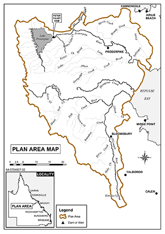
This plan applies to the area shown as the plan area on the map in schedule 1.
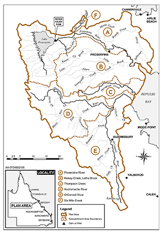
Each part of the plan area that is within a subcatchment area shown on the map in schedule 2 is a subcatchment area for this plan.
6Declaration about watercourse—Act, s 1006(2)
(1)Groundwater in an aquifer under the relevant watercourse or under land adjacent to the relevant watercourse is declared to be water in a watercourse.(2)Subsection (1) does not apply to water that is not hydraulically connected to water in the relevant watercourse.(3)The owner of land adjacent to the relevant watercourse may take the groundwater for stock or domestic purposes.(4)In this section—land adjacent, to the relevant watercourse, means land within 200m either side of the relevant watercourse.under, a relevant watercourse or land adjacent to the relevant watercourse, means under the watercourse or land to an unspecified depth.relevant watercourse means the Proserpine River AMTD 25.7km to 57.0km.
(1)The exact location of the boundaries of the plan area and subcatchment areas is held in digital electronic form by the department.(2)The information held in digital electronic form can be reduced or enlarged to show the details of the boundaries.
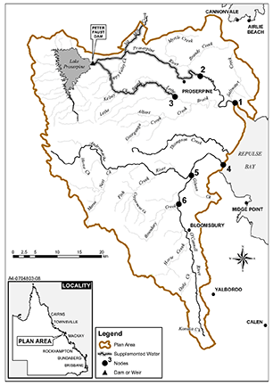
(1)A node mentioned in this plan is a place on a watercourse in the plan area.(2)The location of each node is—(a)shown on the map in schedule 3, part 1; and(b)described in schedule 3, part 2.(3)Each node is identified on the map by a number.
(1)This plan applies to the following water (surface water) in the plan area—(a)water in a watercourse, lake or spring;(b)overland flow water.(2)This plan also applies to groundwater in the plan area.
10Outcomes for water in plan area
Water is to be allocated and sustainably managed in a way that—(a)recognises the natural state of watercourses, lakes, and springs has changed because of water infrastructure, flow supplementation and the taking of water; and(b)seeks to achieve a balance in the following outcomes—(i)the general outcomes mentioned in section 11;(ii)the general ecological outcomes mentioned in sections 12 and 13;(iii)the specific ecological outcomes mentioned in section 14.
(1)Each of the following is a general outcome for the plan area—(a)to protect the probability of being able to take water under a water allocation;(b)to support water-related cultural values, including the cultural values of Aboriginal and Torres Strait Islander communities, in the plan area;(c)to provide for the continued use of all—(i)existing water entitlements; and(ii)existing overland flow works; and(iii)existing water bores;(d)to make water available to support—(i)irrigated agriculture in the plan area; and(ii)urban and industrial growth in the plan area; and(iii)stock or domestic purposes in the plan area; and(iv)water-related aesthetic, economic and recreational values in the plan area, including, for example, tourism;(e)to make surface water in the following areas available to support growth in irrigated agriculture and water supplies for urban and industrial uses—(i)subcatchment area B;(ii)subcatchment area C;(iii)subcatchment area D;(iv)subcatchment area E;(f)to maintain the ability to take surface water or groundwater for stock or domestic purposes;(g)to encourage continual improvement in the efficient use of water;(h)to ensure water is available to support natural ecosystem processes.(2)In this section—existing water entitlement means a water entitlement in force immediately before the plan notification day.
(1)Each of the following is a general ecological outcome for the plan area—(a)to maintain the natural variability of flows that support the habitats of native plants and animals and migratory birds in watercourses, floodplains, wetlands, lakes and springs;(b)to provide for the continued capability of 1 part of a river system to be connected to another, including by maintaining flood flows that—(i)allow for the movement of native aquatic animals between riverine, floodplain, wetland, estuarine and marine environments; and(ii)deliver nutrients and organic matter throughout the plan area to support natural processes such as breeding, growth and migration in riverine, floodplain, wetland, estuarine and marine environments; and(iii)deliver water and sediment throughout the plan area to support river-forming processes;(c)to minimise changes to natural variability in water levels and to support natural ecological processes, including maintaining refugia associated with waterholes and lakes;(d)to promote improved understanding of the matters affecting flow-related health of ecosystems in the plan area;(e)to provide a flow regime that—(i)supports native fish passage within watercourses in the plan area; and(ii)supports ecological productivity in the receiving waters of the Great Barrier Reef, inshore reefs and Repulse Bay; and(iii)maintains delivery of fresh water to the estuaries of watercourses in the plan area and Repulse Bay; and(iv)maintains natural sedimentation processes to support delivery of sediment and nutrients to estuaries in the plan area.(2)In this section—native fish passage means the natural movement patterns of native fish species required to maintain the biological integrity of the species.refugia means habitats or places supporting populations of animals or plants not able to live elsewhere in the surrounding landscape.Example of refugia in an aquatic system—
Habitats or places where animals or plants may take refuge from drought conditions, floods and high flows, high water temperatures and predation by other animals.
13General ecological outcomes relating to the connectivity of groundwater and surface water
Each of the following is a general ecological outcome relating to groundwater in the plan area—(a)to maintain groundwater contributions to the flow of water in watercourses, lakes and springs;(b)to support the ecosystems dependent on groundwater, including, for example, riparian vegetation, wetlands and waterholes;(c)to provide continued connectivity between watercourses, lakes and springs, and aquifers.
14Specific ecological outcomes
Each of the following is a specific ecological outcome for the plan area—(a)to minimise adverse impacts on the ecology and morphology of watercourses, lakes and springs in the Proserpine River Water Supply Scheme used for taking supplemented water while recognising changes to the flow regime of the watercourses, lakes and springs resulting from water resource development;(b)to maintain flood flows to the estuarine and marine environments of Repulse Bay to stimulate breeding, growth and migration of native aquatic animals;(c)to maintain the natural variability of flood flows that inundate, and deliver nutrients, organic matter and sediment to, the wetlands of the area known as the Proserpine–Goorganga Plain Wetland.
This chapter applies to surface water, other than overland flow water, in the plan area.
16Environmental flow objectives
The environmental flow objectives are stated in schedule 4.
17Performance indicators for environmental flow objectives
The performance indicators for the environmental flow objectives are—(a)for assessing periods of low flow at the nodes mentioned in schedule 4, part 1—(i)50% non-zero daily flow; and(ii)80% non-zero daily flow; and(iii)90% non-zero daily flow; and(iv)daily flow volume; and(v)80% non-zero daily flow in a water flow season; and(vi)a period of no flow of at least 30 consecutive days; and(vii)a period of no flow of at least 90 consecutive days; and(b)for assessing periods of medium to high flow at the nodes mentioned in schedule 4, part 2—(i)mean annual flow; and(ii)median annual flow; and(iii)1.5 year daily flow volume; and(iv)5 year daily flow volume; and(v)20 year daily flow volume; and(vi)annual proportional flow deviation.
18Water allocation security objectives
The water allocation security objectives for this plan are stated in—(a)for water allocations to take supplemented water— schedule 5, part 1; and(b)for water allocations to take unsupplemented water— schedule 5, part 2.
19Performance indicators for water allocation security objectives
(1)The performance indicators for the water allocation security objectives for taking supplemented water are—(a)for priority groups A and A1—(i)annual supplemented water sharing index; and(ii)monthly supplemented water sharing index; and(b)for priority group A2—(i)90% annual supplemented water sharing index; and(ii)90% monthly supplemented water sharing index; and(c)for priority group A3—(i)75% annual supplemented water sharing index; and(ii)75% monthly supplemented water sharing index.(2)The performance indicators for the water allocation security objectives for taking unsupplemented water are—(a)30% unsupplemented water sharing index; and(b)50% unsupplemented water sharing index; and(c)70% unsupplemented water sharing index; and(d)annual volume probability.
20Application of pt 1
This part applies to both surface water and groundwater.
s 21 om 2014 SL No. 142 s 238
22Matters to be considered for environmental management rules
(1)In deciding the environmental management rules to be included in the resource operations plan, the chief executive is to consider—(a)the streamflows required to maintain the following—(i)the longitudinal connectivity of low flow habitats throughout the subcatchment areas in the plan area;(ii)the wetted habitats at riffles and other streambed features;(iii)the natural seasonality of flows and zero flows;(iv)the replenishment of refuge pools that enable movement of instream biota;(v)groundwater flows;(vi)the contributions from aquifers to the flow of water in watercourses;(vii)the lateral connectivity between rivers in the plan area and their adjacent riverine environments, including floodplains; and(b)the impact the taking of, or proposed taking of, or interfering with, water may have on the following—(i)water quality;(ii)the natural movement of sediment and nutrients;(iii)the inundation of habitats;(iv)the movement of fish and other aquatic animals;(v)the recreation and aesthetic values of the plan area;(vi)cultural values including, for example, cultural values of local Aboriginal or Torres Strait Islander communities.(2)Subsection (1) does not limit the matters the chief executive may consider.
23Matters to be considered for water sharing rules
(1)In deciding the water sharing rules to be included in the resource operations plan for authorisations to take water in a part of the plan area, the chief executive is to consider—(a)for rules relating to supplemented water—(i)any existing water sharing rules; and(ii)the extent to which any existing water supply arrangements are linked to the natural occurrence of streamflows; and(b)for rules relating to unsupplemented water or groundwater—(i)any existing water sharing arrangements; and(ii)the local availability of water that may be taken from streamflows, waterholes, bedsands or aquifers; and(iii)the conditions for taking water decided under section 58; and(iv)the daily volumetric limits decided under section 64; and(v)the nominal entitlements decided under section 65; and(vi)the impact of the rules on authorisations to take water in the plan area.(2)Subsection (1) does not limit the matters the chief executive may consider.(3)In this section—existing water sharing rules means water sharing rules in force on the plan notification day.existing water supply arrangements means water supply arrangements in place on the plan notification day.
ch 5 pt 1 div 2 hdg om 2014 SL No. 142 s 239
s 24 om 2014 SL No. 142 s 239
25Application of div 3
This division applies to unallocated water.
ch 5 pt 1 div 3 sdiv 2 hdg om 2014 SL No. 142 s 240
s 26 om 2014 SL No. 142 s 240
27Unallocated water held as general reserve or strategic reserve
Unallocated water is held as a general reserve (general unallocated water) or strategic reserve (strategic unallocated water) and dealt with under this division.
28Purposes for which unallocated water may be granted
(1)General unallocated water may be granted for any purpose.(2)Strategic unallocated water may be granted only if it is to be taken for a State purpose.
29Total volume of unallocated water
The total of the nominal entitlements for all water licences and annual volumetric limits for all water allocations for taking—(a)general unallocated water from a subcatchment area mentioned in schedule 6, part 1, column 1, is stated in the schedule, part 1, column 2, opposite the subcatchment area; and(b)strategic unallocated water from a subcatchment area mentioned in schedule 6, part 2, column 1, is stated in the schedule, part 2, column 2, opposite the subcatchment area.
30Period for which strategic unallocated water is granted for particular State purpose
(1)This section applies to water licences for taking strategic unallocated water for either of the following State purposes—(a)a project of State significance;(b)a project of regional significance.(2)Water granted for a project is granted only for the life of the project and the right to take the water returns to the State on the conclusion of the project.
31Projects that may be considered to be of regional significance
The chief executive may consider a particular project to be a project of regional significance for the plan area only if the chief executive considers the project is significant for a region in the plan area, having regard to the following—(a)the outcomes under chapter 3;(b)the economic or social impact the project will have on the region;(c)the public interest and the welfare of people in the region;(d)any other relevant consideration.
32Flow conditions for general unallocated water
(1)This section applies to a water entitlement granted—(a)to take groundwater; or(b)to take surface water from a watercourse, lake or spring, other than to take for stock or domestic purposes.(2)General unallocated water may be granted only with a flow condition that prevents the taking of water that is required to maintain the following—(a)the longitudinal connectivity of low flow habitats throughout the subcatchment areas in the plan area;(b)the wetted habitats at riffles and other streambed features;(c)the natural seasonality of flows and zero flows;(d)the replenishment of refuge pools that enable movement of instream biota;(e)groundwater flows;(f)the contributions from aquifers to the flow of water in watercourses;(g)the lateral connectivity between rivers in the plan area and their adjacent riverine environments, including floodplains.
33Preparing and implementing process under the resource operations plan generally
(1)Unallocated water is dealt with under a process stated in the resource operations plan.(2)In preparing and implementing the process, the chief executive is to consider the following—(a)the purpose for which the water is required;(b)the efficiency of existing and proposed water use practices;(c)the extent to which water is being taken under existing authorisations in the plan area;(d)the availability of an alternative water supply for the purpose for which the water is required;(e)the impact the proposed taking of, or interfering with, the water may have on existing water users, the operations of resource operations licence and distribution operations licence holders in the plan area;(f)whether the proposed taking or interfering is likely to have a direct adverse effect on groundwater flows;(g)the matters mentioned in section 22(1).(3)Subsection (2) does not limit the matters the chief executive may consider.(4)The resource operations plan will state that use, for irrigation, of water taken under a water licence granted under section 212 of the Act requires a land and water management plan approved under section 77 of the Act.(5)In this section—existing, in relation to an authorisation, water use practice or water user, means existing at the time the process stated in the resource operations plan is being prepared.
34Application of pt 2
The strategies stated in this part apply to surface water in addition to the strategies stated in part 1.
35Decisions consistent with objectives
Decisions about the allocation or management of surface water, other than a decision about a water permit, must be consistent with—(a)the environmental flow objectives; and(b)the water allocation security objectives.
36Assessing impact of decisions
(1)The IQQM computer program’s simulation for the simulation period is used to assess consistency with the environmental flow objectives and the water allocation security objectives.(2)If it is not practicable to use the IQQM computer program, another assessment method approved by the chief executive may be used.(3)The chief executive may approve an assessment method for subsection (2) only if the chief executive is satisfied the method will assess consistency with the objectives at least as accurately as the IQQM computer program.
ch 5 pt 2 div 2 sdiv 1 hdg om 2014 SL No. 142 s 241
ch 5 pt 2 div 2 sdiv 2 hdg om 2014 SL No. 142 s 242
37Water allocations to be managed under a resource operations licence
Water allocations converted from interim water allocations to take water from the Proserpine River Water Supply Scheme are to be managed under a resource operations licence.
38Water allocation to which water is to be distributed under a distribution operations licence
(1)A water allocation converted from an authorisation to take water distributed through water infrastructure owned by the Kelsey Creek Water Board is a water allocation to which the Kelsey Creek Water Board’s distribution operation licence applies.(2)A water allocation converted from an authorisation to take water distributed through water infrastructure owned by the Six Mile Creek Water Supply Board is a water allocation to which the Six Mile Creek Water Supply Board’s distribution operation licence applies.
39Matters to be considered for infrastructure operating rules
(1)In deciding the infrastructure operating rules to be included in the resource operations plan for water infrastructure or proposed infrastructure for supplemented water, the chief executive considers—(a)the impact of the infrastructure’s or proposed infrastructure’s operation on the following—(i)instream water levels;(ii)bed and banks of watercourses;(iii)riparian vegetation; and(b)the extent to which artificial variations in instream water levels and flows may adversely affect natural ecosystems; and(c)the impact on the transfer of water between watercourses; and(d)the likelihood of fish deaths caused by the operation of the infrastructure; and(e)the matters mentioned in section 22(1).(2)Subsection (1) does not limit the matters the chief executive may consider.
s 40 om 2014 SL No. 142 s 242
s 41 om 2014 SL No. 142 s 242
s 42 om 2014 SL No. 142 s 242
s 43 om 2014 SL No. 142 s 242
s 44 om 2014 SL No. 142 s 242
s 45 om 2014 SL No. 142 s 242
s 46 om 2014 SL No. 142 s 242
s 47 om 2014 SL No. 142 s 242
48Purpose of sdiv 1
This subdivision states strategies for authorisations to be converted, under section 121 of the Act, to water allocations to take unsupplemented water under the resource operations plan.
49Restrictions on taking water from waterholes
(1)This section applies to the chief executive in making a decision about taking unsupplemented water from a waterhole under—(a)a water allocation; or(b)a water licence.(2)The chief executive must—(a)consider the impact the taking may have on the cultural or ecological values of the waterhole; and(b)impose a condition on the allocation or licence about maintaining the cultural or ecological values of the waterhole.(3)However, the chief executive need not impose a condition mentioned in subsection (2)(b) if the chief executive is satisfied—(a)the taking of water from the waterhole will not adversely affect its cultural or ecological values; or(b)for a water licence or water allocation that replaces an authorisation in force immediately before the plan notification day—the holder of the authorisation would suffer economic hardship if the condition were imposed.
50Authorisations to be converted to water allocations
The authorisations to be converted to water allocations to take unsupplemented water are water licences for taking unsupplemented water from—(a)the Andromache River, including its tributaries, downstream from its confluence with Horse Creek AMTD 37.8km; and(b)the O’Connell River, including its tributaries, downstream from its confluence with Kanaka Creek AMTD 52.9km.
51Elements of water allocations to take unsupplemented water
A water allocation to take unsupplemented water must state the following—(a)the maximum rate at which water may be taken under the allocation;(b)the daily volumetric limit for the allocation;(c)the annual volumetric limit for the allocation.s 51 sub 2014 SL No. 142 s 243
52Location for taking water under water allocation
The location for taking water to be stated on a water allocation to take unsupplemented water must include the place at which water could have been taken under the authorisation.
53Purpose to be stated on water allocation
The purpose to be stated on a water allocation to take unsupplemented water must be—(a)if the purpose stated on the authorisation is stock, domestic, amenities, irrigation, stock intensive, agriculture or a similar purpose—‘rural’; or(b)otherwise—‘any’.
54Nominal volume for water allocation
In deciding the nominal volume for a water allocation to take unsupplemented water, the chief executive must consider the following—(a)the local availability of water;(b)the conditions under which water may be taken under the authorisation;(c)for an authorisation that states an annual volume—the stated volume;(d)the simulated mean annual diversion for the authorisation.
(1)The maximum rate at which unsupplemented water may be taken under a water allocation to take unsupplemented water is—(a)for an authorisation that states a maximum rate—the stated rate; and(b)for an authorisation that does not state a maximum rate but for which a related development permit—(i)states a pump size mentioned in schedule 7, column 1—the rate stated in schedule 7, column 2, for the pump size; or(ii)states a pump size other than a pump size mentioned in schedule 7, column 1—the rate decided by the chief executive having regard to the rates stated for similar pump sizes in schedule 7, column 2; and(c)for another authorisation—the rate decided by the chief executive having regard to—(i)the type of authorisation; and(ii)an estimate or measurement of the rate at which water can be taken under the authorisation.(2)However, for subsection (1)(b), if the authorisation holder satisfies the chief executive that the maximum rate at which water can be taken is different from the rate decided under the subsection, the maximum rate is the rate decided by the chief executive having regard to the following—(a)the conditions under which the water may be taken;(b)the water taking capacity of the pump to which the development permit relates (the existing pump);(c)the irrigation or water distribution system related to the existing pump during the period, of not more than 10 years, immediately before the plan notification day;(d)the efficiency of the system mentioned in paragraph (c).
(1)The daily volumetric limit for a water allocation to take unsupplemented water is—(a)for an authorisation that states the daily volumetric limit—the stated volume; and(b)for an authorisation that does not state a volume but for which a related development permit—(i)states a pump size mentioned in schedule 7, column 1—the daily volumetric limit stated in schedule 7, column 3, for the pump size; or(ii)states a pump size other than a pump size mentioned in schedule 7, column 1—the daily volumetric limit decided by the chief executive having regard to the daily volumetric limits stated for similar pump sizes in schedule 7, column 3; and(c)for another authorisation—the daily volumetric limit decided by the chief executive having regard to—(i)the type of authorisation; and(ii)an estimate or measurement of the rate at which water can be taken under the authorisation.(2)However, for subsection (1)(b), if the authorisation holder satisfies the chief executive that the water taking capacity of the pump is different from the daily volumetric limit decided under the subsection, the daily volumetric limit is the volume decided by the chief executive having regard to the following—(a)the conditions under which the water may be taken under the authorisation;(b)the water taking capacity of the pump to which the development permit relates (the existing pump) under normal operating conditions;(c)the irrigation or water distribution system related to the existing pump during the period, of not more than 10 years, immediately before the plan notification day;(d)the efficiency of the system mentioned in paragraph (c).(3)The chief executive must ensure the daily volumetric limit for a water allocation is not more than the total volume that could be taken in a day at the maximum rate decided, for the water allocation, under section 55.
The annual volumetric limit for a water allocation to take unsupplemented water is—(a)for an authorisation that states the volume of water that may be taken in a 12 month period—the stated volume; and(b)for an authorisation that states an area that may be irrigated—the volume decided by the chief executive having regard to the volume of water required for the authorisation’s intended purpose, but not more than the volume, expressed in megalitres, calculated by multiplying the area in hectares by 5; and(c)for another authorisation—the volume decided by the chief executive having regard to the following—(i)the conditions under which water may be taken under the authorisation;(ii)the water taking capacity of any works for taking water under the authorisation;(iii)the volume required for the allocation’s intended purpose;(iv)the annual volumes of water estimated by the chief executive to have been taken under the authorisation during the period, of not more than 10 years, immediately before the plan notification day;(v)the efficiency of the use of the water mentioned in subparagraph (iv).
58Conditions relating to flow conditions
In deciding the conditions relating to flow conditions under which water may be taken under a water allocation, the chief executive must consider any conditions relating to flow conditions stated on the authorisation.
59Water allocation groups for water allocations
A water allocation to take unsupplemented water in subcatchment areas D or E belongs to—(a)for an authorisation that does not state a flow condition—water allocation group 1; and(b)for another authorisation—water allocation group 2.
60Application of sdiv 2
This subdivision applies to water licences for taking unsupplemented water.
61Elements of water licences to take unsupplemented water
A water licence to take unsupplemented water must state the following—(a)the purpose for which the water may be taken under the licence;(b)the maximum rate at which water may be taken under the licence;(c)the daily volumetric limit for the licence;(d)the nominal entitlement for the licence;(e)the flow conditions, if any, for the licence.
62Purpose to be stated on water licence
The purpose to be stated on a water licence to take unsupplemented water, replacing an existing water licence, must be—(a)if the purpose stated on the existing water licence is stock or domestic—‘stock and domestic’; or(b)if the purpose stated on the existing water licence is irrigation, stock intensive, agriculture or a similar purpose—‘rural’; or(c)otherwise—‘any’.s 62 amd 2016 SL No. 216 s 146 sch 20
The maximum rate at which unsupplemented water may be taken under a water licence is the maximum rate mentioned in section 55 or decided by the chief executive under that section as if the water licence were a water allocation.s 63 sub 2014 SL No. 142 s 244
The daily volumetric limit to take unsupplemented water for a water licence is the daily volumetric limit mentioned in section 56 or decided by the chief executive under that section as if the water licence were a water allocation.s 64 sub 2014 SL No. 142 s 244
The nominal entitlement for a water licence to take unsupplemented water is—(a)for a water licence that states a volume of water that may be taken—the stated volume; and(b)for a water licence that states the area that may be irrigated—the volume decided by the chief executive having regard to the volume of water required for the licence’s intended purpose, but not more than the volume, expressed in megalitres, calculated by multiplying the area, in hectares, by 5; and(c)for another water licence—the volume decided by the chief executive having regard to—(i)the conditions under which water may be taken under the licence; and(ii)the water taking capacity of any works for taking water under the licence; and(iii)the volume required for the licence’s intended purpose; and(iv)the annual volumes of water estimated by the chief executive to have been taken under the licence during the period, of not more than 10 years, immediately before the plan notification day; and(v)the efficiency of the use of the water mentioned in subparagraph (iv).
The chief executive may impose on a water licence to take unsupplemented water any condition relating to flow conditions the chief executive is satisfied is necessary to ensure the purposes and outcomes of this plan are achieved.
67Limitation on taking overland flow water—Act, s 20(2)
(1)This section alters the overland flow water that may be taken under section 20(2) of the Act.(2)A person may only take overland flow water—(a)for stock or domestic purposes; or(b)using works that have a capacity of not more than 20ML; or(c)under a water licence to take overland flow water; or(d)of not more than the amount necessary to satisfy the requirements of—(i)an environmental authority issued under the Environmental Protection Act 1994; or(ii)a development permit for carrying out an environmentally relevant activity, other than a mining or petroleum activity, under the Environmental Protection Act 1994; or(e)that is contaminated agricultural runoff water; or(f)under section 68.(3)In this section—contaminated agricultural runoff water has the meaning given by the ‘Code for assessable development for operational works for taking overland flow water’.A copy of the code is available on the department’s website.s 67 amd 2013 Act No. 23 s 352 sch 1 pt 2
68Taking water using particular existing overland flow works authorised
(1)This section applies to the owner of land on which existing overland flow works are situated, other than works for taking only the overland flow water that may be taken under section 67(2)(a) to (e).(2)The owner may continue to use the existing overland flow works to take overland flow water for 1 year after the plan notification day.(3)Also, if the owner gives the chief executive notice of the existing overland flow works, in the approved form, and any further information reasonably required by the chief executive about the works, the owner may continue to use the works to take overland flow water after the notice and information are given.(4)However, the authorisation under subsection (3) ceases to apply if the owner is granted a water licence relating to the works.
69Granting water licences for using particular existing overland flow works
(1)This section applies if the resource operations plan states, under section 212 of the Act, a process for the allocation of water under a water licence to replace the authorisation under section 68.(2)Under the process the chief executive—(a)must consider—(i)the average annual volume of overland flow water that could have been taken, immediately before the plan notification day, using the existing overland flow works to which section 68 applies; and(ii)the annual volumes of overland flow water estimated by the chief executive to have been taken using the works during the period, of not more than 10 years, immediately before the plan notification day; and(b)may consider the extent to which the works, immediately before the plan notification day, allowed—(i)the taking of water, other than overland flow water, under another authorisation; or(ii)the storage of water, other than overland flow water, under another authorisation.(3)Subsection (2) does not limit the matters the chief executive may consider.(4)The chief executive may require the owner of the land to which section 68 applies to give the chief executive a certificate, from a registered professional engineer, stating information about the works including the capacity of the works and the rate at which the works may take water.(5)In this section—registered professional engineer means a person registered as a registered professional engineer under the Professional Engineers Act 2002.
s 70 om 2016 SL No. 216 s 146 sch 20
71Application of pt 3
The strategies stated in this part apply to groundwater in addition to the strategies stated in part 1.
72Limitation on taking groundwater—Act, s 20(2)
(1)This section alters the groundwater that may be taken under section 20(2) of the Act.(2)A person may only take groundwater in the plan area—(a)under a water permit; or(b)under a water licence; or(c)under section 73; or(d)for stock or domestic purposes.s 72 amd 2013 Act No. 23 s 352 sch 1 pt 2
73Taking groundwater using existing works
(1)This section applies to an owner of land in the undeclared area on which there are works (existing works) that the chief executive is satisfied were used, or capable of being used, to take groundwater for any purpose other than stock or domestic purposes immediately before the plan notification day.(2)The owner may continue to take groundwater in the undeclared area using the existing works for 1 year after the plan notification day.(3)If the owner gives the chief executive notice in the approved form of the existing works within 1 year after the plan notification day, the owner may continue to take groundwater in the undeclared area using the works.(4)However, an authorisation under this section ceases to apply to an owner in relation to existing works if the owner is granted a water licence relating to the works.(5)In this section—undeclared area means all parts of the plan area other than the area that, immediately before the plan notification day, was declared under section 1046 of the Act as the Proserpine subartesian area.
74Granting water licences for using particular existing works
(1)The chief executive may, under section 212 of the Act, grant a water licence to a person authorised under section 73(2) to continue taking groundwater.(2)The licence must be consistent with this part.
75Elements of water licences to take groundwater
A water licence to take groundwater must state—(a)a nominal entitlement that may be taken under the licence; and(b)the purpose for which groundwater may be taken under the licence; and(c)a monthly volumetric limit or quarterly volumetric limit, if any, that may be taken under the licence; and(d)the conditions, if any, under which the groundwater may be taken.
76Nominal entitlements for authorisations
(1)This section applies if the chief executive decides the nominal entitlement for an authorisation for continuing to take groundwater using existing works for a purpose other than stock or domestic purposes.(2)The nominal entitlement must be the estimated volume to take groundwater for the entitlement.(3)However, if the chief executive is satisfied the volume of groundwater taken during the relevant period (a higher volume) is more than the estimated volume, the chief executive may decide a nominal entitlement that is more than the estimated volume.(4)In considering whether a higher volume of groundwater was taken during the relevant period, the chief executive must consider each of the following—(a)the capacity of the existing works to take groundwater as at the plan notification day;(b)the number of hours the existing works were operated during the relevant period;(c)for existing works for irrigation purposes—the volume of groundwater estimated by the chief executive to have been taken during the relevant period for irrigating crops grown during the period;(d)for existing works for a purpose other than irrigation purposes—the volume of groundwater estimated by the chief executive to have been taken during the relevant period for the purpose;(e)the efficiency of the use of the groundwater mentioned in paragraph (c) or (d);(f)the availability of groundwater in the aquifer to which the works relate;(g)the availability of other water sources in the area to which the water entitlement relates;(h)the density of water bores for taking groundwater in the area to which the water entitlement relates.(5)Subsection (4) does not limit the matters the chief executive may consider.(6)In this section—capacity, of existing works, means—(a)if the water bore for the works has a design pumping rate only—the design pumping rate for the bore; or(b)if the works have an equipped rate only—the equipped rate for the works; or(c)if the works have a design pumping rate and an equipped rate—the lesser of the design pumping rate and the equipped rate; or(d)the volume of groundwater available in the parts of an aquifer that are under the land to which the works relate, that must not be more than 1ML/ha of the parts of the aquifer.design pumping rate, for a water bore, means the pumping rate—(a)at which the bore can be pumped without causing the bore’s pump to break suction; and(b)estimated from an analysis of a pumping test based on the drawdown available in the bore above the pump inlet that would sustain pumping for 70 consecutive days.equipped rate, for existing works, means the rate at which pumping equipment installed on the works can be pumped for the purposes for which the works are used.estimated volume, to take groundwater for a water entitlement, means the least of the following—(a)the volume worked out by multiplying the capacity of the existing works by the number of hours, that must not be more than 1200 hours, the chief executive decides having regard to—(i)the efficiency of the use of groundwater using the works during the relevant period; and(ii)the availability of other water sources in the area to which the water entitlement relates;(b)the volume of groundwater taken using existing works for irrigation purposes during the relevant period, that must not be more than 5ML of water for each hectare irrigated;(c)the volume of groundwater taken using existing works for a purpose other than irrigation purposes during the relevant period, that must not be more than 10ML;(d)the volume of groundwater available in an aquifer under the land to which the works relate, that must not be more than 1ML/ha of the aquifer.existing works means works that the chief executive is satisfied were used or capable of being used to take groundwater for a purpose other than stock or domestic purposes on the plan notification day.relevant period means each 1 year period during the period of not more than 10 years immediately before the plan notification day.
77Purpose to be stated on water licence to take groundwater
(1)The purpose to be stated on a water licence to take groundwater in the plan area must be—(a)if the intended use of the water is for, or the licence is an existing water licence and the purpose stated on the licence is irrigation, stock intensive, agriculture, agricultural dewatering or a similar purpose—‘rural’; or(b)otherwise—‘any’.(2)In this section—agricultural dewatering means taking groundwater to alleviate or prevent the waterlogging of agricultural soils.
s 78 amd 2014 Act No. 29 s 164
om 2016 SL No. 216 s 146 sch 20
ch 6 hdg sub 2014 SL No. 142 s 245
79Monitoring and reporting requirements
(1)To help the Minister assess the effectiveness of the management strategies for achieving the outcomes mentioned in chapter 3, the resource operations plan must state—(a)the monitoring requirements for water and natural ecosystems for this plan; and(b)the reporting requirements for this plan for operators of infrastructure interfering with water in the plan area.(2)Subsection (1) does not limit the monitoring requirements the chief executive may impose for this plan.s 79 sub 2014 SL No. 142 s 245
80Minister’s report on plan—Act, s 53
(1)The Minister’s report on this plan must be prepared for a period (the reporting period)—(a)starting on the commencement of this plan; and(b)ending within 5 years—(i)for the first report—after the beginning of the financial year in which this plan commenced; and(ii)for subsequent reports—after the end of the previous reporting period.(2)The Minister’s report must be prepared within 12 months after the end of the reporting period to which the report relates.(3)In this section—previous reporting period, in relation to a reporting period, means the reporting period immediately preceding the reporting period.s 80 sub 2014 SL No. 142 s 245
s 81 om 2014 SL No. 142 s 245
s 82 om 2014 SL No. 142 s 245
(1)This section states the proposed arrangements for implementing this plan.(2)Within 2 years after the plan notification day, it is proposed to prepare a resource operations plan to—(a)grant, or convert authorisations to, water allocations to take water in all of the priority areas; and(b)for water in the Proserpine River Water Supply Scheme—make environmental management rules, infrastructure operating rules, water sharing rules, water allocation change rules and seasonal water assignment rules; and(c)establish a process to deal with unallocated water available for future water requirements in the plan area; and(d)establish a process for granting water under water licences for taking overland flow water; and(e)implement the monitoring requirements mentioned in chapter 6; and(f)provide better specification for all other water licences for taking or interfering with water in the plan area.(3)In this section—priority area means each of the following—(a)the parts of La Di Da Creek, Kelsey Creek and Lethe Brook that are in the authority area of the Kelsey Creek Water Board;(b)the part of Six Mile Creek that is in the authority area of the Six Mile Creek Water Supply Board;(c)the Proserpine River;(d)the Andromache River, other than its tributaries, downstream from its confluence with Horse Creek AMTD 37.8km;(e)the O’Connell River, other than its tributaries, downstream from its confluence with Kanaka Creek AMTD 52.9km.
84Minor or stated amendment of plan—Act, s 57
The following types of amendment may be made to this plan under section 57(b) of the Act—(a)an amendment or addition of an environmental flow objective if the amendment or addition achieves an equivalent or improved ecological outcome without adversely affecting the outcomes under chapter 3 or water allocation security objectives;(b)an amendment or addition of a water allocation security objective if the amendment or addition does not adversely affect the outcomes under chapter 3 or environmental flow objectives;(c)an amendment or addition of a node;(d)an amendment to adjust the boundaries of a subcatchment area if more accurate information about the boundaries of the plan area or hydrological characteristics of the plan area becomes available;(e)an amendment or addition of a priority group;(f)an amendment or addition of a water allocation group;(g)an amendment of the capacity mentioned in section 67(2)(b);(h)an amendment or addition of a monitoring or reporting requirement under chapter 6.s 84 amd 2014 SL No. 142 s 246
The Minister must consider amending this plan or preparing a new plan to replace this plan if the Minister is satisfied—(a)in relation to this plan’s general outcomes under section 11—(i)water entitlements in the plan area are not sufficient to meet water needs sourced from the plan area having regard to—(A)the extent to which water is being taken under the water entitlements; and(B)the efficiency of present, and expected future, water use; and(C)emerging requirements for additional water; and(D)water savings that may be made from improvements in the efficiency of water use or the use of water from other sources including, for example, recycled water; and(E)the likely timeframe in which additional water will be required; and(ii)there are economically viable and ecologically sustainable uses for additional water; or(b)this plan’s outcomes mentioned in sections 12 to 14 are not being achieved.
Column 1 | Column 2 |
Node | Location |
1 | Proserpine end of system (AMTD 0.0km) |
2 | Proserpine River at the end of supplemented water system (AMTD 25.7km) |
3 | Lethe Brook at Gauging Station GS122012A (AMTD 26.7km) |
4 | O’Connell River at the end of the system (AMTD 0.0km) |
5 | Andromache River at its confluence with the O’Connell River (AMTD 0.0km) |
6 | O’Connell River at Stafford’s Crossing (AMTD 19.7km) |
Column 1 Column 2 Column 3 Column 4 Column 5 Node % % % % 1 45 77 86 4 2 41 74 82 13 3 38 65 71 21 4 36 56 64 22 5 38 59 66 20 6 34 66 72 171At each node mentioned in table 1, column 1—
(a)the percentage of the total number of days in the simulation period that the 50% non-zero daily flow is equalled or exceeded be at least the percentage stated, for the node, in table 1, column 2; and
(b)the percentage of the total number of days in the simulation period that the 80% non-zero daily flow is equalled or exceeded be at least the percentage stated, for the node, in table 1, column 3; and
(c)the percentage of the total number of days in the simulation period that the 90% non-zero daily flow is equalled or exceeded be at least the percentage stated, for the node, in table 1, column 4; and
(d)the percentage of the total number of days in the simulation period that the daily flow volume is zero be not more than the percentage stated, for the node, in table 1, column 5.
Table 1
2At each node mentioned in table 2, column 1, the percentage of the total number of days in a water flow season in the simulation period that the 80% non-zero daily flow is equalled or exceeded be at least the percentage stated for the water flow season, for the node, in table 2, column 2.Table 2
Column 1
Column 2
Water flow season
Node
December - March
April - July
August - November
4
63
62
42
5
61
65
44
6
67
70
59
3At each node mentioned in table 3, column 1—(a)the number of periods of no flow of at least 30 consecutive days in the simulation period be not more than the number stated for the node in table 3, column 2; and(b)the number of periods of no flow of at least 90 consecutive days in the simulation period be not more than the number stated for the node in table 3, column 3.Table 3
Column 1
Column 2
Column 3
Node
No. of periods of no flow of at least 30 consecutive days
No. of periods of no flow of at least 90 consecutive days
1
2
0
2
5
0
3
40
10
4
86
14
5
37
6
6
52
12
Column 1 Column 2 Column 3 Column 4 Column 5 Column 6 Node Mean annual flow Median annual flow 1.5 year daily flow volume 5 year daily flow volume 20 year daily flow volume 1 83 84 97 86 87 2 74 71 89 90 89 3 97 99 99 99 99 4 91 81 83 98 98 5 85 82 69 94 95 6 83 68 65 97 964At each node mentioned in table 4, column 1—
(a)the mean annual flow in the simulation period, expressed as a percentage of the mean annual flow for the pre-development flow pattern, be at least the percentage stated for the node in table 4, column 2; and
(b)the median annual flow in the simulation period, expressed as a percentage of the median annual flow for the pre-development flow pattern, be at least the percentage stated for the node in table 4, column 3; and
(c)the 1.5 year daily flow volume in the simulation period, expressed as a percentage of the 1.5 year daily flow volume for the pre-development flow pattern, be at least the percentage stated for the node in table 4, column 4; and
(d)the 5 year daily flow volume in the simulation period, expressed as a percentage of the 5 year daily flow volume for the pre-development flow pattern, be at least the percentage stated for the node in table 4, column 5; and
(e)the 20 year daily flow volume in the simulation period, expressed as a percentage of the 20 year daily flow volume for the pre-development flow pattern, be at least the percentage stated for the node in table 4, column 6.
Table 4
5At each node mentioned in table 5, column 1, the annual proportional flow deviation in the simulation period be not more than the annual proportional flow deviation stated for the node in table 5, column 2.Table 5
Column 1
Column 2
Node
Annual proportional flow deviation
1
1.2
2
2.1
3
0.7
4
1.2
5
1.1
6
1.5
For water allocations in priority group A—(a)that the annual supplemented water sharing index be at least 97% and the extent to which it is less than 100% be minimised; and(b)that the monthly supplemented water sharing index be at least 99% and the extent to which it is less than 100% be minimised.
For water allocations in priority group A1—(a)that the annual supplemented water sharing index be at least 65% and the extent to which it is less than 70% be minimised; and(b)that the monthly supplemented water sharing index be at least 75% and the extent to which it is less than 80% be minimised.
For water allocations in priority group A2—(a)that the 90% annual supplemented water sharing index be at least 65% and the extent to which it is less than 70% be minimised; and(b)that the 90% monthly supplemented water sharing index be at least 75% and the extent to which it is less than 80% be minimised.
For water allocations in priority group A3—(a)that the 75% annual supplemented water sharing index be at least 65% and the extent to which it is less than 70% be minimised; and(b)that the 75% monthly supplemented water sharing index be at least 75% and the extent to which it is less than 80% be minimised.
5Water allocations to take unsupplemented water
For water allocations in each water allocation group mentioned in the table, column 1—(a)that the 30% unsupplemented water sharing index be at least the percentage stated in column 2 for the water allocation group; and(b)that the 50% unsupplemented water sharing index be at least the percentage stated in column 3 for the water allocation group; and(c)that the 70% unsupplemented water sharing index be at least the percentage stated in column 4 for the water allocation group; and(d)that the annual volume probability be at least the percentage stated in column 5 for the water allocation group.Table
Column 1
Column 2
Column 3
Column 4
Column 5
Water allocation group
30%
unsupplemented
water sharing index
50%
unsupplemented
water sharing index
70%
unsupplemented
water sharing index
Annual volume probability
1
121
99
78
48
2
124
95
55
44
Schedule 6 Total of nominal entitlements for all water licences and annual volumetric limits for all water allocations
Column 1 | Column 2 |
Subcatchment area | Total volume |
B and C | 9500ML |
D and E | 19,000ML |
Column 1 | Column 2 |
Subcatchment area | Total volume |
B and C | 500ML |
D and E | 1000ML |
sections 55, 56, 63 and 64
Column 1 | Column 2 | Column 3 |
Pump size (mm) | Maximum rate (litres/second) | Daily volumetric limit (ML) |
32 | 8 | 0.6 |
40 | 16 | 1 |
50 | 25 | 1.5 |
65 | 46 | 3.5 |
80 | 65 | 3.9 |
100 | 95 | 6.9 |
125 | 120 | 7.8 |
150 | 150 | 12.1 |
200 | 220 | 15.6 |
250 | 300 | 21.6 |
300 | 350 | 25.9 |
350 | 400 | 30.2 |
375 to 400 | 500 | 37.2 |
500 | 660 | 47.5 |
600 to 610 | 1200 | 86.4 |
650 to 660 | 1700 | 120 |
1.5 year daily flow volume, for a node, means the daily flow volume that has a 67% probability of being reached at least once a year.
5 year daily flow volume, for a node, means the daily flow volume that has a 20% probability of being reached at least once a year.
20 year daily flow volume, for a node, means the daily flow volume that has a 5% probability of being reached at least once a year.
30% unsupplemented water sharing index, for a group of authorisations, means the total volume of water simulated to have been taken annually under the authorisations in at least 30% of years in the simulation period, if the authorisations were in existence for the whole of the simulation period, expressed as a percentage of the simulated mean annual diversion for the authorisations.
50% non-zero daily flow, for a node, means the daily flow that is equalled or exceeded on 50% of the days when there is flow in the simulation period for surface water for the pre-development flow pattern.
50% unsupplemented water sharing index, for a group of authorisations, means the total volume of water simulated to have been taken annually under the authorisations in at least 50% of years in the simulation period, if the authorisations were in existence for the whole of the simulation period, expressed as a percentage of the simulated mean annual diversion for the authorisations.
70% unsupplemented water sharing index, for a group of authorisations, means the total volume of water simulated to have been taken annually under the authorisations in at least 70% of years in the simulation period, if the authorisations were in existence for the whole of the simulation period, expressed as a percentage of the simulated mean annual diversion for the authorisations.
75% annual supplemented water sharing index, for water allocations in a particular priority group, means the percentage of years in the simulation period in which 75% of the nominal volumes of the allocations are supplied.
75% monthly supplemented water sharing index, for water allocations in a particular priority group, means the percentage of months in the simulation period in which 75% of the nominal volumes of the allocations are supplied.
80% non-zero daily flow, for a node, means the daily flow that is equalled or exceeded on 80% of the days when there is flow in the simulation period for surface water for the pre-development flow pattern.
90% annual supplemented water sharing index, for water allocations in a particular priority group, means the percentage of years in the simulation period in which 90% of the nominal volumes of the allocations are supplied.
90% monthly supplemented water sharing index, for water allocations in a particular priority group, means the percentage of months in the simulation period in which 90% of the nominal volumes of the allocations are supplied.
90% non-zero daily flow, for a node, means the daily flow that is equalled or exceeded on 90% of the days when there is flow in the simulation period for surface water for the pre-development flow pattern.
adopted middle thread distance means the distance in kilometres, measured along the middle of a watercourse, that a specific point in the watercourse is, at the plan notification day, from—
(a)the watercourse’s mouth; or
(b)if the watercourse is not a main watercourse—the watercourse’s confluence with its main watercourse.
AMTD means the adopted middle thread distance.
annual flow volume, for a node, means the total volume of flow in a 12 month period starting on 1 July.
annual proportional flow deviation, for a node, means the statistical measure of changes at the node to flow season and volume in the simulation period.
annual supplemented water sharing index, for water allocations in a particular priority group, means the percentage of years in the simulation period in which the nominal volumes of the allocations are fully supplied.
annual volume probability, for a water allocation group, means the percentage of years in the simulation period in which the volume of water that may be taken by the group is at least the total of the nominal volumes for the water allocations for the group.
annual volumetric limit, for an interim water allocation or water allocation, means the maximum volume of water that may be taken under the allocation in a water year.
authorisation means a water licence, water permit, interim water allocation or other authority to take water given under the Act or the repealed Act, other than a water permit for stock or domestic purposes.
daily flow volume, for a node, means the volume of water, expressed in megalitres, that flows past the node in a day.
daily volumetric limit, for a water allocation, means the maximum volume of water that may be taken under the water allocation in a day.
environmental flow objective see section 16.
existing overland flow works—
(a)means overland flow works existing immediately before the plan notification day; and
(b)includes works that—(i)are a reconfiguration of overland flow works mentioned in paragraph (a) (the original works); and(ii)do not increase the average annual volume of water taken above the average annual volume taken using the original works.
existing water bore means a water bore that—
(a)was in existence before the plan notification day; and
(b)is able to take groundwater.
existing water licence means a water licence in force on the plan notification day.
general unallocated water see section 27.
groundwater means underground water.
sch 8 def groundwater amd 2016 SL No. 216 s 146 sch 20
infrastructure operating rules means, for infrastructure to which the resource operations plan applies, the infrastructure operating rules included in the resource operations plan.
IQQM computer program means the department’s Integrated Quantity and Quality Modelling computer program, and associated statistical analysis and reporting programs, that simulate daily stream flows, flow management, storages, releases, instream infrastructure, water diversions, water demands and other hydrologic events in the plan area.
Kelsey Creek Water Board means the Kelsey Creek Water Board established under section 548 of the Act.
See also the Water Regulation 2002, section 31 (Water authorities established—Act, s 548).
mean annual flow, for a node, means the total volume of flow in the simulation period divided by the number of years in the simulation period.
median annual flow, for a node, means the annual flow volume that is equalled or exceeded in 50% of years in the simulation period.
monthly supplemented water sharing index, for water allocations in a particular priority group, means the percentage of months in the simulation period in which the nominal volumes of the allocations are fully supplied.
node see section 8.
nominal entitlement see the Water Regulation 2016, section 28.
sch 8 def nominal entitlement amd 2016 SL No. 216 s 146 sch 20
nominal volume means the volume of water, expressed in megalitres, representing the share of the water available to be taken by holders of water allocations in a priority group or a water allocation group.
operator of infrastructure for interfering with water means—
(a)the holder of a resource operations licence or a distributions operations licence; or
(b)an operator of infrastructure for interfering with water, mentioned in the resource operations plan.
period of no flow, for a node, means a period in which the watercourse ceased to flow at the node.
plan area see section 4.
plan notification day means the day this plan was notified in the gazette.
pre-development flow pattern means the pattern of water flows, during the simulation period, decided by the chief executive using the IQQM computer program as if—
(a)there were no dams or other water infrastructure in the plan area; and
(b)no water was taken under authorisations in the plan area.
priority group means a priority group mentioned in schedule 5, part 1.
sch 8 def priority group sub 2014 SL No. 142 s 247
project of regional significance means a project the chief executive considers, under section 31, to be a project of regional significance for this plan.
project of State significance means a project declared under the State Development and Public Works Organisation Act 1971, section 26, to be a significant project.
Proserpine River Water Supply Scheme means—
(a)until the resource operations plan commences—a scheme for supplying water under an interim resource operations licence for the Proserpine River Water Supply Scheme; and
(b)on and from the day the resource operations plan commences—the scheme for supplying water under the resource operations licence for the Proserpine River Water Supply Scheme.
related development permit, for an authorisation, means the development permit for the works for taking water under the authorisation.
resource operations plan means the resource operations plan to implement this plan.
simulated mean annual diversion, for an authorisation, or a group of authorisations (the group), means the total volume of water simulated to have been taken under the authorisation or group, if the authorisation or group of authorisations was in existence for all of the simulation period for surface water, divided by the number of years in the simulation period.
simulation period means the period from 1 January 1890 to 31 December 2004.
Six Mile Creek Water Supply Board means the Six Mile Creek Water Supply Board established under section 548 of the Act.
See also the Water Regulation 2002, section 31 (Water authorities established—Act, s 548).
State purpose means a project of State significance or project of regional significance.
strategic unallocated water see section 27.
subcatchment area see section 5.
supplemented water means water supplied under a resource operations licence or other authority to operate water infrastructure.
surface water see section 9(1).
this plan means this water resource plan.
unallocated water means water available for allocation in the plan area.
unsupplemented water means surface water that is not supplemented water.
water allocation group means a water allocation group mentioned in section 59.
water allocation security objective see section 18.
water flow season means the following periods in a year—
(a)the period from 1 December to 31 March (December–March);
(b)the period from 1 April to 31 July (April–July);
(c)the period from 1 August to 30 November (August–November).
waterhole means a part of a watercourse that contains water after the watercourse ceases to flow, other than a part of a watercourse that is within the storage area of a dam on the watercourse.