


This water plan may be cited as the Water Plan (Pioneer Valley) 2002.s 1 sub 2014 Act No. 64 s 255 sch 2
The following are the purposes of this plan—(a)to define the availability of water in the plan area;(b)to provide a framework for sustainably managing water and the taking of water;(c)to identify priorities and mechanisms for dealing with future water requirements;(d)to provide a framework for establishing water allocations;(e)to provide a framework for reversing, where practicable, degradation that has occurred in natural ecosystems;(f)to regulate the taking of groundwater.s 2 amd 2009 SL No. 212 s 3
The dictionary in schedule 10 defines particular words used in this plan.
This plan applies to the area shown as the plan area on the map in schedule 1.
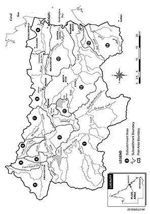
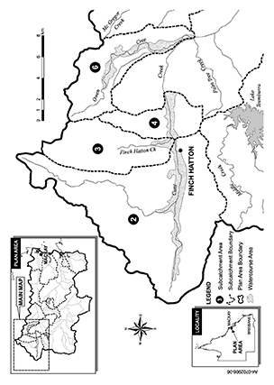
Each part of the plan area that is within a subcatchment area shown on the map in schedule 2 is a subcatchment area for this plan.
5AGroundwater management area and groundwater sub-areas
(1)The groundwater management area is the area shown on the map in schedule 2A.(2)Each part of the groundwater management area that is within a groundwater sub-area shown on the map in schedule 2B is a groundwater sub-area for this plan.(3)A groundwater sub-area contains all the aquifers in the groundwater sub-area.s 5A ins 2009 SL No. 212 s 4
5BWatercourse area and declaration about watercourse—Act, s 1006(2)
(1)The watercourse area is the part of the plan area shown on the map in schedule 2C.(2)Groundwater in an aquifer under a watercourse, or under land adjacent to a watercourse, in the watercourse area is declared to be water in a watercourse (declared water).s 5B ins 2009 SL No. 212 s 4
(1)The exact location of the following is held in digital electronic form by the department—(a)the boundaries of the plan area, subcatchment areas, groundwater management area, groundwater sub-areas, watercourse area and domestic areas;(b)the coastline and seawater intrusion baseline.(2)The information held in digital electronic form can be reduced or enlarged to show the details of the boundaries.The boundary locations in digital electronic form may be inspected at the department’s office at 22–30 Wood Street, Mackay.s 6 amd 2009 SL No. 212 s 5
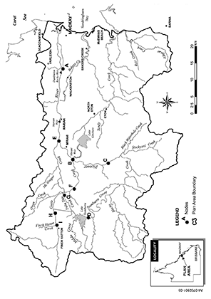
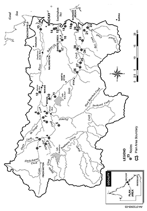
(1)A node mentioned in this plan is a place—(a)on a watercourse in the plan area or in the groundwater management area; and(b)for which environmental flow objectives are set for performance indicators.(2)The location of each node is shown on the map in schedule 1 or schedule 2A and described in schedule 3.(3)Each node is identified on the map by a letter of the alphabet or number.s 7 amd 2009 SL No. 212 s 6
This plan applies to the following water in the plan area—(a)water in a watercourse, lake or spring (surface water);(b)groundwater.s 8 amd 2009 SL No. 212 s 7
8AOutcomes for water in plan area
Water is to be allocated and sustainably managed in a way that—(a)recognises the natural state of watercourses, lakes, springs and aquifers has changed because of water infrastructure, flow supplementation and the taking of water; and(b)seeks to achieve a balance in the following outcomes—(i)the general outcomes mentioned in sections 9 and 9A;(ii)the general ecological outcomes mentioned in sections 10 and 18A;(iii)the specific ecological outcomes mentioned in sections 12 to 18.s 8A ins 2009 SL No. 212 s 8
9General outcomes for surface water and groundwater
Each of the following is a general outcome for water in the plan area—(a)to ensure a reliable and secure supply of water from the plan area during the time this plan is in force;(b)to protect the probability of being able to obtain water under a water allocation;(c)to provide for the opportunity for additional surface water to be taken from the Sandy Creek catchment area to reduce reliance on groundwater in areas affected, or likely to be affected, by seawater intrusion;(d)to provide the opportunity for additional surface water to be taken from the Pioneer River for future water requirements;(e)to allow water to be used for the following—(i)agriculture;(ii)aquaculture;(iii)industrial needs;(iv)small scale uses;(v)stock and domestic purposes;(vi)tourism and recreational uses;(vii)urban needs;(f)to provide for the continued use of all water entitlements and other authorisations to take or interfere with surface water;(g)to encourage the efficient use of water;(h)to allow cultural use by Aboriginal or Torres Strait Islander communities;(i)to provide water to support natural ecosystems including natural groundwater-dependent ecosystems.s 9 amd 2009 SL No. 212 s 9; 2016 SL No. 216 s 146 sch 20
9AGeneral outcomes for groundwater
(1)Each of the following is a general outcome for groundwater in the plan area—(a)to maintain the capability of a part of a groundwater flow system to be connected to a watercourse, lake or spring where there are users of surface water dependent on baseflow;(b)to provide for the continued use of water entitlements and other authorisations to take groundwater in a groundwater sub-area, other than water entitlements and other authorisations to take groundwater in an affected groundwater sub-area (the affected water entitlements);(c)to provide the opportunity to recover, in affected groundwater sub-areas, the use of the affected water entitlements;(d)to maintain and protect, where practicable, the quality of groundwater for consumptive purposes;Example of a consumptive purpose—
irrigation(e)to prevent further seawater intrusion.(2)In this section—affected groundwater sub-area means a groundwater sub-area affected or likely to be affected by seawater intrusion to the extent that the ability to take water under a water entitlement is reduced or extinguished.groundwater flow system means a discrete 3 dimensional system through which groundwater flows from the area where groundwater is recharged to the area where groundwater is discharged from the system.groundwater sub-area means a groundwater sub-area or part of a groundwater sub-area.s 9A ins 2009 SL No. 212 s 10
10General ecological outcomes for surface water and groundwater
Each of the following is a general ecological outcome for water in the plan area—(a)to maintain habitats of native plants and animals in watercourses, lakes, springs and groundwater;(b)to maintain riparian systems and their functions influencing the riverine ecosystems;(c)to maintain and favour native plants and animals associated with watercourses, lakes, springs and groundwater and riparian zones;(d)to provide wet season flow to benefit native plants and animals in estuaries;(e)to maintain long term water quality suitable for riverine and estuarine ecosystems and groundwater-dependent ecosystems;(f)to maintain existing geomorphic features and processes;(g)to maintain the capability of one part of the river system to be connected to another through the flow of water—(i)throughout the watercourse network; and(ii)within the riparian zone, floodplain and watercourses, lakes, springs and groundwater;(h)to maintain ecosystem food chains, their balance and the movement of carbon energy.s 10 amd 2009 SL No. 212 s 11
pt 3 div 2 hdg sub 2009 SL No. 212 s 12
11Application of div 2
Without limiting section 10, the ecological outcomes mentioned in this division apply to the parts of the plan area mentioned.
(1)An ecological outcome for surface water is to provide a flow regime—(a)to maintain delivery of freshwater, sediment, nutrients and organic matter to the estuaries of watercourses; and(b)to maintain the brackish water habitat in the estuaries.(2)Also, an ecological outcome for surface water is to protect and improve the ecology of the Pioneer River estuary by reducing the frequency and duration of periods of no flow to the estuary.s 12 amd 2009 SL No. 212 s 13
13Blacks Creek and Pioneer River
(1)This section applies to surface water in—(a)Blacks Creek downstream of Teemburra Creek; and(b)the Pioneer River upstream of Mirani Weir.(2)An ecological outcome for the water is to minimise adverse impacts on environmental conditions and geomorphic processes in Blacks Creek and the river while recognising the likelihood of changes to the conditions and processes resulting from the existence and operation of Teemburra Dam.s 13 amd 2009 SL No. 212 s 14
14Subcatchment areas 2, 3 and 4
An ecological outcome for surface water in subcatchment area 2, 3 or 4 is to maintain areas and species of significant conservation value in the creeks in the subcatchment areas.s 14 amd 2009 SL No. 212 s 15
An ecological outcome for surface water in subcatchment area 12 is to reduce seawater intrusion in the coastal section of the Pioneer Valley groundwater system associated with the area.s 15 amd 2009 SL No. 212 s 16
An ecological outcome for surface water in Palm Tree Creek downstream of the diversion pipeline outlet from Teemburra Dam is to minimise adverse impacts on environmental conditions and geomorphic processes in the creek while recognising the likelihood of—(a)erosion of the creek’s bed and banks, and loss of riparian vegetation, because of flow supplementation; and(b)changes to the creek’s instream and riparian habitats resulting from a more perennial flow regime.s 16 amd 2009 SL No. 212 s 17
An ecological outcome for surface water in Silver Creek downstream of the outlet for the diversion channel for surface water from Cattle Creek is to minimise adverse impacts on environmental conditions and geomorphic processes in Silver Creek while recognising the likelihood of changes to the creek’s instream and riparian habitats resulting from a more perennial flow regime.s 17 amd 2009 SL No. 212 s 18
An ecological outcome for surface water in Teemburra Creek downstream of Teemburra Dam is to minimise adverse impacts on environmental conditions and geomorphic processes in the creek while recognising the likelihood of the following resulting from the existence and operation of the dam—(a)reduction of sediment, and changed geomorphic processes, in the creek;(b)spread of riparian vegetation into the creek;(c)increased opportunity for weed growth in the creek’s riparian zones;(d)depletion of flood-spawning species, including, for example, spangled perch and neosilurid catfishes.s 18 amd 2009 SL No. 212 s 19
pt 3 div 3 hdg ins 2009 SL No. 212 s 20
18AGeneral ecological outcomes
Each of the following is a general ecological outcome for groundwater in the plan area—(a)to maintain biological diversity of groundwater-dependent ecosystems;(b)to maintain groundwater levels at depths, and groundwater flows, providing for the groundwater requirements of groundwater-dependent ecosystems;(c)to maintain the capability of groundwater to flow from a part of an aquifer to another part of the aquifer or to watercourses, lakes, estuaries, near-shore marine systems or wetlands.s 18A ins 2009 SL No. 212 s 20
pt 4 div 1 sdiv 1 hdg ins 2009 SL No. 212 s 21
19Performance indicators for environmental flow objectives
The performance indicators for the environmental flow objectives are—(a)for assessing periods of low flow—(i)50% daily flow; and(ii)90% daily flow; and(iii)daily flow less than 1ML; and(iv)number of periods of no flow of at least 1 month but less than 3 months; and(v)number of periods of no flow of at least 3 months; and(b)for assessing periods of medium to high flow—(i)mean annual flow; and(ii)1.5 year daily flow volume; and(iii)5 year daily flow volume; and(iv)20 year daily flow volume; and(c)for assessing seasonal flow patterns—(i)flow regime class; and(ii)annual proportional flow deviation; and(iii)mean wet season flow; and(d)for assessing baseflow in subcatchment area 12—(i)daily flow less than 1ML; and(ii)daily flow less than 50ML.s 19 amd 2009 SL No. 212 s 22
20Environmental flow objectives
The environmental flow objectives for surface water are stated in schedule 4, parts 1 to 4.s 20 amd 2009 SL No. 212 s 23
pt 4 div 1 sdiv 2 hdg ins 2009 SL No. 212 s 24
20AEnvironmental flow objectives
The environmental flow objectives for groundwater are stated in schedule 4, parts 5 and 6.s 20A ins 2009 SL No. 212 s 24
20BPerformance indicators for environmental flow objectives—relevant groundwater-dependent ecosystems
The performance indicator for the environmental flow objectives for assessing flow to a relevant groundwater-dependent ecosystem is the drawdown deviation.s 20B ins 2009 SL No. 212 s 24
sub 2014 SL No. 142 s 201
20CPerformance indicator for environmental flow objectives—seawater intrusion
(1)The performance indicator for the environmental flow objectives for assessing the extent of seawater intrusion is the maximum seawater intrusion area.(2)In this section—seawater intrusion area means the area of land, expressed in hectares, between the coastline and the seawater intrusion front.s 20C ins 2009 SL No. 212 s 24
21Performance indicators for water allocation security objectives
The performance indicators for the water allocation security objectives are—(a)for taking supplemented water—the monthly supplemented water sharing index; and(b)for taking unsupplemented water—(i)30% unsupplemented water sharing index; and(ii)50% unsupplemented water sharing index; and(iii)70% unsupplemented water sharing index; and(c)for taking groundwater—the annual volume probability.s 21 amd 2009 SL No. 212 s 25
22Water allocation security objectives
The water allocation security objectives for this plan are stated in—(a)for water allocations to take supplemented water—schedule 5, part 1; and(b)for water allocations to take unsupplemented water—schedule 5, part 2; and(c)for water allocations to take groundwater—schedule 5, part 3.s 22 amd 2009 SL No. 212 s 26
pt 4A hdg ins 2009 SL No. 212 s 27
pt 4A div 1 hdg ins 2009 SL No. 212 s 27
s 22A ins 2009 SL No. 212 s 27
om 2014 SL No. 142 s 202
22BNominal entitlement or annual volumetric limit
(1)The chief executive must decide the following—(a)the nominal entitlement for a water licence to take declared water in the watercourse area granted under section 30A;(b)the nominal entitlement for a water licence to take groundwater in the part of the undeclared area in groundwater sub-area 1, 2, 3, or 15 granted under section 49J;(c)the annual volumetric limit for a water allocation to take groundwater mentioned in section 49K converted from authorisation 3.(2)The nominal entitlement or annual volumetric limit must not be more than the estimated volume to take groundwater for the entitlement.(3)However, if the chief executive is satisfied the volume of groundwater taken during the relevant period (a higher volume) is more than the estimated volume, the chief executive may decide a nominal entitlement or annual volumetric limit that is more than the estimated volume.(4)In considering whether a higher volume of groundwater was taken during the relevant period, the chief executive must have regard to each of the following—(a)the capacity of existing works to take groundwater as at the plan amendment day;(b)the number of hours existing works were operated during the relevant period;(c)for existing works for irrigation purposes—the volume of groundwater estimated by the chief executive to have been taken during the relevant period for irrigating crops grown during the period;(d)for existing works for a purpose other than irrigation purposes—the volume of groundwater estimated by the chief executive to have been taken during the relevant period for the purpose;(e)the efficiency of the use of the groundwater mentioned in paragraph (c) or (d);(f)for existing works for taking water under a water licence to take groundwater in the Pioneer locality—the nominal entitlement stated on the licence;(g)the availability of groundwater in the aquifer to which the works mentioned in paragraph (a), (b), (c), (d), or (f) relate;(h)the availability of other water sources in the area to which the water entitlement relates;(i)the density of water bores for taking groundwater in the area to which the water entitlement relates.(5)Subsection (4) does not limit the matters the chief executive may consider.(6)In this section—capacity of existing works means—(a)if the water bore for the works has a design pumping rate only—the design pumping rate for the bore; or(b)if the works have an equipped rate only—the equipped rate for the works; or(c)if the works have a design pumping rate and an equipped rate—the lesser of the design pumping rate for the bore, or the equipped rate, for the works.design pumping rate, for a water bore, means the pumping rate—(a)at which the bore can be pumped without causing the bore’s pump to break suction; and(b)estimated from an analysis of a pumping test based on the drawdown available in the bore above the pump inlet that would sustain pumping for 70 consecutive days.equipped rate, for works, means the rate at which pumping equipment installed on the works can be pumped for the purposes for which the works are used.estimated volume, to take groundwater for a water entitlement, means the least of the following—(a)the volume worked out by multiplying the capacity of existing works by the number of hours, that must not be more than 1200 hours, the chief executive decides having regard to—(i)the efficiency of the use of groundwater using the works during the relevant period; and(ii)the availability of other water sources in the area to which the water entitlement relates;(b)the volume of groundwater taken using existing works for irrigation purposes during the relevant period that must not be more than 3ML of water for each hectare irrigated;(c)the volume of groundwater taken using existing works for a purpose other than irrigation purposes during the relevant period that must not be more than 10ML;(d)the volume of groundwater taken under a water licence to take groundwater in the Pioneer locality using existing works that must not be more than the nominal entitlement stated on the licence;(e)the availability of groundwater in an aquifer that must not be more than 1ML/ha of aquifer under the land to which the works mentioned in paragraph (a), (b), (c) or (d) relate.existing works means works that the chief executive is satisfied were used or capable of being used to take groundwater for a purpose other than stock or domestic purposes on 24 June 2003.Pioneer locality means the Pioneer locality, declared by order in council published in the gazette on 21 June 1947.relevant period means each 1 year period during the period of not more than 10 years immediately before the plan amendment day.s 22B ins 2009 SL No. 212 s 27
pt 4A div 2 hdg ins 2009 SL No. 212 s 27
22CContinued effect of moratorium notice published on 20 September 2000—Act, s 46(3)
(1)This section continues, in part, the effect of the moratorium notice, published on 20 September 2000.(2)This section applies to an application under the Act or the repealed Act if granting the application would have 1 or more of the following effects on surface water to which this plan relates—(a)increase the amount of surface water taken or interfered with;(b)change the location from which the surface water may be taken or interfered with;(c)increase the maximum rate for taking or interfering with the surface water;(d)change the conditions under which the surface water may be taken;(e)change the purpose for which surface water may be taken.(3)The application will be accepted but not dealt with until the resource operations plan deals with the allocation of unallocated surface water in the area to which the application relates.(4)However, subsection (3) does not apply to an application—(a)for a water permit; or(b)by an interim resource operations licence holder to transfer an interim water allocation; or(c)for a licence, or amendment of a licence, to take water managed by the Pioneer Valley Water Board; or(d)to reinstate or replace an expired licence.(5)The chief executive’s acceptance of an application does not give the applicant priority in having the application decided.s 22C (prev s 49) amd 2009 SL No. 212 s 44
renum and reloc 2009 SL No. 212 s 44(3)
22DContinued effect of moratorium notice published on 25 June 2003 and subsequently amended—Act, s 46(3)
(1)This section continues, in part, the effect of the moratorium notice published on 25 June 2003 and amended on 29 September 2005 and 28 June 2008.(2)Subsection (3) applies to an application for a water licence to take or interfere with surface water in subcatchment area 13 or 14, or to take groundwater, made on or after 25 June 2003, if granting the application would have 1 or more of the following effects—(a)increase the amount of water that may be taken or interfered with;(b)change the location from which the water may be taken or interfered with;(c)increase the maximum rate for taking or interfering with the water.(3)The application will not be accepted until the resource operations plan is approved.(4)However, subsection (3) does not apply to an application—(a)to reinstate, under section 221 of the Act, an expired water licence; or(b)to amalgamate, under section 224 of the Act, 2 or more water licences in force immediately before the plan amendment day; or(c)to replace, under section 225 of the Act, an original licence with 2 or more water licences; or(d)to replace, under section 229 of the Act, an expired licence with 1 or more water licences.(5)Works to take groundwater must not be physically started.(6)However, subsection (5) does not apply to the following works—(a)works for taking groundwater for stock or domestic purposes on land in domestic area A other than a part of the area affected by seawater intrusion;(b)works for taking groundwater for stock or domestic purposes on land in domestic area B, other than a part of the area affected by seawater intrusion, if there are no existing works on the land and—(i)a plan of survey for a reconfiguration of the land is registered before 28 June 2008; or(ii)a plan of survey for a reconfiguration of the land is registered on or after 28 June 2008 and the reconfiguration does not result in more lots being created on the land than existed immediately before the reconfiguration; or(iii)a reconfiguration of the land is undertaken by a constructing authority under the Acquisition of Land Act 1967 and the plan of survey for the reconfiguration of the land is registered on or after 28 June 2008; or(iv)part of the land is acquired by voluntary acquisition for a public purpose by a constructing authority and the plan of survey for the acquisition is registered on or after 28 June 2008;(c)works authorised by or associated with mining tenements granted under the Mineral Resources Act 1989;(d)works, replacing existing works, to be constructed within 10m of the existing works.(7)Completed, or partly completed, works existing immediately before the plan amendment day must not be changed, enlarged or deepened, other than works for town water supply west of 149o east.(8)In this section—149o east means the area described as 149o east worked out using the Geocentric Datum of Australia 1994, commonly called ‘GDA94’, notified in the Commonwealth Government Gazette No. GN 35 on 6 September 1995, at page 3369.existing works means works for taking or interfering with water that the chief executive is satisfied were installed and operable before 28 June 2008.s 22D ins 2009 SL No. 212 s 27
s 22E ins 2009 SL No. 212 s 27
om 2014 SL No. 142 s 203
pt 4A div 3 hdg ins 2009 SL No. 212 s 27
s 22F ins 2009 SL No. 212 s 27
om 2014 SL No. 142 s 204
22GElectrical conductivity—groundwater
(1)The chief executive must decide whether to install a meter for measuring and recording the electrical conductivity of groundwater taken under a water entitlement using a water bore on land in groundwater sub-area 11, 12, 13, 15, 16 or 17.(2)In deciding whether to install the meter, the chief executive must have regard to—(a)the electrical conductivity of the groundwater in the sub-area; and(b)the proximity of the bore to the seawater intrusion front.(3)If the chief executive decides to install the meter, it must be used from the day and in the circumstances mentioned in the resource operations plan.s 22G ins 2009 SL No. 212 s 27
pt 5 hdg amd 2009 SL No. 212 s 28
23Decisions consistent with objectives
Decisions about the allocation or management of surface water in the plan area, other than a decision in relation to a water permit, must be consistent with—(a)the environmental flow objectives stated in schedule 4, part 1, 2, 3 or 4; and(b)the water allocation security objectives stated in schedule 5, part 1 or 2.s 23 amd 2009 SL No. 212 s 29
24Assessing impact of decisions
(1)The IQQM computer program’s simulation for the simulation period for surface water is used to assess consistency with the objectives.(2)If it is not practicable to use the IQQM computer program, another assessment method approved by the chief executive may be used.(3)The chief executive may approve an assessment method for subsection (2) only if the chief executive is satisfied the method will assess consistency with the objectives at least as accurately as the IQQM computer program.s 24 amd 2009 SL No. 212 s 30
25Taking or interfering with water from waterholes or lakes
(1)This section applies to the chief executive in making a decision about—(a)a licence for taking unsupplemented water; or(b)converting an authorisation for taking unsupplemented water into a water allocation; or(c)the management of surface water under a resource operations licence.(2)If the licence, water allocation or resource operations licence allows taking or interfering with water from a waterhole or lake, the chief executive must—(a)consider the impact the taking may have on the cultural or ecological values of the waterhole or lake; and(b)impose a condition on the licence, water allocation or resource operation licence about maintaining the cultural or ecological values of the waterhole or lake.a condition that the water may be taken only if the water level in the waterhole or lake is above the level that is 0.5m below the level at which it naturally overflows(3)However, the chief executive need not impose a condition mentioned in subsection (2)(b) if the chief executive is satisfied—(a)the taking of water from the waterhole or lake will not adversely affect its cultural or ecological values; or(b)for a licence or water allocation that replaces an authorisation in force immediately before the commencement of this plan—the holder of the authorisation would suffer economic hardship if the condition were imposed.s 25 amd 2009 SL No. 212 s 31
26Matters chief executive must consider
(1)In preparing and implementing a process for dealing with unallocated surface water under a resource operations plan, the chief executive must consider—(a)the efficiency of existing and proposed water use practices; and(b)the availability of an alternative water supply for the purpose for which the water is required; and(c)the impact the proposed taking of, or interfering with, the water may have on the following—(i)water quality;(ii)inundation of habitats;(iii)the movement of fish and other aquatic species;(iv)the natural movement of sediment;(v)recreation and aesthetic values;(vi)cultural values, including, for example, cultural values of local Aboriginal or Torres Strait Islander communities; and(d)whether the proposed taking or interfering is likely to have a direct adverse effect on groundwater flows.(2)Subsection (1) does not limit the matters the chief executive may consider.s 26 amd 2009 SL No. 212 s 32
27Licences for unallocated surface water in subcatchment area 12
(1)The chief executive may grant a licence for taking surface water from subcatchment area 12 only if the nominal entitlement for the licence does not result in the total nominal entitlements for licences granted after the commencement being more than 4000ML.(2)The chief executive must impose conditions on the licence that—(a)surface water may be taken only if—(i)the taking does not stop surface water from flowing immediately downstream of the place where the surface water is taken; and(ii)there is surface flow greater than 1400ML a day at gauging station 126001 situated on Sandy Creek at Homebush; and(b)the licensee must start taking surface water under the licence within 2 years after the day the licence is granted.(3)The licence must state the nominal entitlement and the maximum rate at which surface water may be taken under the licence.s 27 amd 2009 SL No. 212 s 33
pt 5 div 3 hdg sub 2014 SL No. 142 s 205
s 28 om 2014 SL No. 142 s 206
29Matters chief executive must consider
(1)In deciding the operating arrangements and supply requirements for water infrastructure, the chief executive must consider—(a)the impact of the infrastructure’s operation on the following—(i)water quality;(ii)instream water levels;(iii)erosion of the bed and banks of watercourses;(iv)riparian vegetation;(v)the extent to which artificial variations in instream water levels and flows may adversely affect natural ecosystems;(vi)recreation and aesthetic values;(vii)cultural values, including, for example, cultural values of local Aboriginal or Torres Strait Islander communities; and(b)the impact of the infrastructure on the movement of fish and other aquatic species; and(c)the impact of the transfer of water between watercourses; and(d)the likelihood of fish deaths caused by the operation of the infrastructure.(2)Subsection (1) does not limit the matters the chief executive may consider.s 29 amd 2014 SL No. 142 s 207
pt 5 div 4 hdg sub 2014 SL No. 142 s 208
s 30 om 2014 SL No. 142 s 209
30AGranting water licences to take declared water
(1)This section applies if, under section 37 of the Act, a chief executive’s notice requires the owner of land in the watercourse area on which there are existing works for taking groundwater to notify the chief executive of the works and the water use.(2)After the chief executive receives the notice, the chief executive may, under section 212 of the Act, grant a water licence to the owner to take declared water using the works.(3)The licence must be—(a)granted under a process stated in the resource operations plan; and(b)consistent with part 5A, division 7.(4)However, for the purpose of granting a water licence under this section, a reference in part 5A, division 7 to groundwater is taken to be a reference to declared water.(5)In this section—existing works means works that the chief executive is satisfied were used or capable of being used to take groundwater for a purpose other than stock or domestic purposes on 24 June 2003.s 30A ins 2009 SL No. 212 s 34
amd 2011 Act No. 40 s 107 sch
31Definition for div 5
In this division—authorisation means an authorisation or authority mentioned in section 32.
32Application of div 5
This division applies only to—(a)authorisations converted, under the resource operations plan, to water allocations; and(b)water allocations converted, under the resource operations plan, from authorisations.s 32 amd 2014 SL No. 142 s 210
33Conditions of authorisations
(1)The chief executive must not include on an allocation, a condition of the authorisation that allowed the holder of the authorisation to take surface water in addition to the volume stated on the authorisation.Example of a condition for subsection (1)—
a condition allowing the taking of surface water as an ‘out of allocation supply’(2)Subsection (1) does not apply to a condition stating flow conditions under which surface water may be taken for the purpose of water harvesting.s 33 amd 2009 SL No. 212 s 35
34Location for taking surface water
The location for taking surface water stated on a surface water allocation must include the place at which surface water could have been taken under the authorisation.s 34 amd 2009 SL No. 212 s 36
35Purpose to be stated on water allocation
(1)If the purpose stated on an authorisation is one of the following, or a similar purpose, the purpose stated on the water allocation must be ‘rural’—(a)stock;(b)domestic;(c)irrigation;(d)stock intensive;(e)agriculture.(2)If the purpose stated on an authorisation is ‘distribution loss’, the purpose stated on the water allocation must be ‘distribution loss’.
pt 5 div 5 sdiv 2 hdg om 2014 SL No. 142 s 211
s 36 om 2014 SL No. 142 s 211
s 37 om 2014 SL No. 142 s 211
s 38 om 2014 SL No. 142 s 211
39Volume of unsupplemented water
A water allocation to take unsupplemented water must state a monthly volumetric limit.s 39 sub 2014 SL No. 142 s 212
40Nominal volume for unsupplemented water
In deciding the nominal volume for a water allocation in a water allocation group mentioned in schedule 6, table 1, column 1, the chief executive—(a)must have regard to—(i)the local availability of water; and(ii)the conditions under which the water may be taken under the authorisation; and(iii)the annual volumes of water estimated by the chief executive to have been taken under the authorisation during the period, of not more than 10 years, immediately before the commencement of this plan; and(iv)the simulated mean annual diversion; and(v)the efficiency of the use of the water mentioned in subparagraph (iii); and(b)must ensure the total of the nominal volumes for the water allocation group is not more than the volume stated in schedule 6, table 1, column 2, for the group.s 40 amd 2009 SL No. 212 s 37
41Annual volumetric limit for unsupplemented water
The annual volumetric limit for a water allocation to take unsupplemented water is—(a)for an authorisation that states an annual volume of water—the stated volume; and(b)for an authorisation that states the area that may be irrigated—the volume decided by the chief executive having regard to the volume of water required to efficiently irrigate the area, but not more than the volume, expressed in megalitres, calculated by multiplying the area, in hectares, by—(i)for conditional licences—3.3; and(ii)for other licences—4.4; and(c)for another authorisation—the volume decided by the chief executive having regard to—(i)the conditions under which water may be taken under the authorisation; and(ii)the water taking capacity of any existing works for taking water under the authorisation; and(iii)the annual volumes of water estimated by the chief executive to have been taken under the authorisation during the period, of not more than 10 years, immediately before the commencement of this plan; and(iv)the efficiency of the use of the water mentioned in subparagraph (iii).
In deciding monthly volumetric limits for a water allocation to take unsupplemented water, the chief executive must have regard to—(a)the local availability of water in each month; and(b)the conditions under which the water may be taken under the authorisation; and(c)the volumes of water estimated by the chief executive to have been taken under the authorisation during the period, of not more than 10 years, immediately before the commencement of this plan; and(d)the simulated mean annual diversion; and(e)the efficiency of the use of the water mentioned in paragraph (c).
43Maximum rates for taking unsupplemented water
The maximum rate at which unsupplemented water may be taken under an allocation is—(a)for an authorisation that states a maximum rate—the stated rate; and(b)for an authorisation that does not state a maximum rate but for which a related development permit states a pump size mentioned in schedule 7, column 1—(i)if the authorisation holder demonstrates that the actual rate at which water can be taken is different from the rate stated in schedule 7, column 2, for the pump size—the rate decided by the chief executive having regard to—(A)the conditions under which the water may be taken; and(B)the water taking capacity of the pump to which the development permit relates (the existing pump) under normal operating conditions; and(C)the irrigation or water distribution system related to the existing pump during the period of not more than 10 years immediately before the commencement of this plan; and(D)the efficiency of the water use mentioned in subsubparagraph (C); or(ii)otherwise—the rate stated in schedule 7, column 2, for the pump size; and(c)for an authorisation that does not state a maximum rate but for which a related development permit states a pump size other than a pump size mentioned in schedule 7, column 1—the rate decided by the chief executive having regard to the matters mentioned in paragraph (b)(i)(A) to (D); and(d)for another authorisation—the rate decided by the chief executive having regard to—(i)the nature of the authorisation; and(ii)an estimate or measurement of the rate at which water is taken under the authorisation.
44Conditions for unsupplemented water allocations
In deciding the conditions under which water may be taken under a water allocation to take unsupplemented water, the chief executive must have regard to the conditions stated on the relevant authorisation.
45Water allocation groups for unsupplemented water allocations
A water allocation to take unsupplemented water in a subcatchment area mentioned in schedule 8, part 1, column 1, belongs to—(a)for an authorisation that states the area that may be irrigated or for town water supply purposes—the water allocation group mentioned in column 2 for the subcatchment area; or(b)for an authorisation to take declared water for a purpose other than stock or domestic purposes—the water allocation group mentioned in column 3 for the subcatchment area; or(c)for other authorisations—the water allocation group mentioned in column 4 for the subcatchment area.s 45 amd 2009 SL No. 212 s 38
46Water licences to take unsupplemented water
A water licence to take unsupplemented water must state—(a)a nominal entitlement for the licence; and(b)the maximum rate at which water may be taken under the licence; and(c)the purpose for which water may be taken under the licence.s 46 sub 2009 SL No. 212 s 39
amd 2014 SL No. 142 s 213
(1)This section states the nominal entitlement for a licence to take unsupplemented water in force on the commencement of this plan.(2)The nominal entitlement is—(a)for a licence or authority that states a volume of water that may be taken—the stated volume; and(b)for a licence that states the area that may be irrigated—the volume decided by the chief executive having regard to the volume of water required to efficiently irrigate the area, but not more than the volume, expressed in megalitres, calculated by multiplying the area, in hectares, by—(i)for a licence in subcatchment area 12 or 14—3.3; and(ii)for a licence in subcatchment area 13—2.5; and(iii)for a conditional licence other than in subcatchment area 12, 13 or 14—3.3; and(iv)for other licences—4.4; and(c)for another licence or authority—the volume decided by the chief executive having regard to—(i)the conditions under which water may be taken under the licence; and(ii)the water taking capacity of any existing works for taking water under the licence; and(iii)the annual volumes of water estimated by the chief executive to have been taken under the licence during the period, of not more than 10 years, immediately before the commencement; and(iv)the efficiency of the use of the water mentioned in subparagraph (iii).s 47 amd 2009 SL No. 212 s 40; 2014 SL No. 142 s 214
48Maximum rates for taking unsupplemented water
The maximum rate at which unsupplemented water may be taken under a water licence is the maximum rate mentioned in section 43 or decided by the chief executive under that section as if the water licence were a water allocation.s 48 sub 2014 SL No. 142 s 215
48APurpose to be stated on water licence
The purpose to be stated on a water licence to take unsupplemented water must be—(a)if the purpose for which the water is being taken is agriculture, aquaculture, domestic, irrigation, stock, stock intensive or a similar purpose—‘rural’; or(b)otherwise—‘any’.s 48A ins 2009 SL No. 212 s 41
pt 5 div 7 hdg sub 2009 SL No. 212 s 42
48BTaking declared water for stock or domestic purposes authorised
(1)This section applies to an owner of land—(a)in the watercourse area; and(b)not adjoining a watercourse in the watercourse area.(2)The owner may take declared water in the area for stock or domestic purposes.s 48B ins 2009 SL No. 212 s 43
pt 5A hdg ins 2009 SL No. 212 s 45
pt 5A div 1 hdg ins 2009 SL No. 212 s 45
49Decisions consistent with objectives
Decisions about the allocation or management of groundwater in the plan area, other than a decision relating to a water permit, must be consistent with—(a)the environmental flow objectives stated in schedule 4, part 5 or 6; and(b)the water allocation security objectives stated in schedule 5, part 3.s 49 ins 2009 SL No. 212 s 43
49AAssessing impact of decisions
(1)The groundwater computer program’s simulation for the simulation period for groundwater is used to assess consistency with the environmental flow objectives and water allocation security objectives for groundwater.(2)If it is not practicable to use the groundwater computer program, another assessment method approved by the chief executive may be used.(3)The chief executive may approve an assessment method for subsection (2) only if the chief executive is satisfied the method will assess consistency with the objectives at least as accurately as the groundwater computer program.(4)In this section—groundwater computer program means the MODFLOW computer program or MODHMS computer program.MODFLOW computer program means the department’s computer program and associated data files, and statistical and data processing programs, that simulate groundwater levels, groundwater demand, recharge and groundwater flows in parts of the plan area.MODHMS computer program means the department’s computer program and associated data files, and statistical and data processing programs, that simulate groundwater levels, groundwater demand, recharge, groundwater flows, river flows and seawater intrusion in parts of the plan area.s 49A ins 2009 SL No. 212 s 43
49BLimitation on taking groundwater—Act, s 20(2)
A person may not take groundwater in the groundwater management area other than—(a)under a water permit; or(b)under a water entitlement; or(c)under an authorisation under section 49I or 49ZB.s 49B ins 2009 SL No. 212 s 43
amd 2013 Act No. 23 s 352 sch 1 pt 2
49CRestrictions on taking groundwater
(1)This section applies to the chief executive in making a decision about—(a)changing a water allocation to take groundwater; or(b)a water licence to take groundwater; or(c)converting a water licence to take groundwater to a water allocation to take groundwater; or(d)taking groundwater involving an exchange between surface water and groundwater.(2)If the allocation or licence allows taking groundwater, the chief executive must—(a)consider the impact the taking may have on the ecological values of a waterhole, lake, hyporheic zone, or streamflow, connected to groundwater; and(b)consider the impact the cumulative taking may have on—(i)surface water flows and groundwater flows; and(ii)other water users; and(iii)seawater intrusion or an area of poor water quality; and(c)impose a condition on the allocation or licence about—(i)maintaining the ecological values of a waterhole, lake, hyporheic zone, or streamflow, connected with the groundwater; ora condition that the groundwater may be taken only if the water level in bore 12600022 is above 22m AHD(ii)limiting the maximum daily, monthly or quarterly rates of take of groundwater.Example for paragraph (c)(ii)—
a condition that the maximum quarterly rate of take of groundwater is 25ML(3)However, the chief executive need not impose a condition mentioned in subsection (2)(c) if the chief executive is satisfied—(a)the taking will not adversely impact on the ecological values or other water users; or(b)for a water allocation or water licence that replaces an authorisation in force immediately before the plan amendment day—the holder of the authorisation would suffer economic hardship if the condition were imposed.(4)Subsection (2) does not limit the matters the chief executive may consider.(5)In this section—AHD means Australian Height Datum.s 49C ins 2009 SL No. 212 s 43
49DDecisions not to increase amount of groundwater taken
(1)The chief executive must not make a decision about the allocation or management of groundwater in the plan area that would—(a)increase the annual volumetric limits for water allocations to take groundwater in the plan area; or(b)increase the nominal entitlements for water licences to take groundwater in the plan area; or(c)allow the taking, other than under a relevant authorisation, of groundwater of an electrical conductivity of more than 1500µS/cm in groundwater sub-area 11, 12, 13, 15, 16 or 17, that is seawater intruded.(2)A decision mentioned in subsection (1)(b) includes a decision about an application for a water licence to take groundwater, made but not decided before the plan amendment day.(3)Subsection (1)(a) and (b) do not apply to a decision—(a)about a water permit; or(b)about an application mentioned in section 22D(4); or(c)to grant a water licence under section 30A; or(d)to grant a water licence under section 49J; or(e)to convert an authorisation to a water allocation mentioned in section 49K.(4)In this section—relevant authorisation means—(a)authorisation 5, 13 or 15 in the part of groundwater sub-area 11, 15, 16 or 17 that is seawater intruded if—(i)for a water year mentioned in schedule 9C—the annual entitlement for the authorisation is decided under section 49Y; or(ii)for a water year starting on or after 1 July 2014—the water taken under the authorisation is for public health purposes; or(b)authorisation 16.s 49D ins 2009 SL No. 212 s 43
amd 2014 SL No. 142 s 216
pt 5A div 2 hdg ins 2009 SL No. 212 s 45
49EMatters to be considered for environmental management rules
(1)In deciding the environmental management rules relating to groundwater to be included in the resource operations plan, the chief executive must consider—(a)the distance of a water bore from a watercourse, lake, spring or area of ecological value; and(b)the groundwater flow regime required to maintain the following—(i)habitats needed by aquatic biota in hyporheic zones;(ii)relevant groundwater-dependent ecosystems;(iii)the connectivity through the flow of water between an aquifer and an adjacent watercourse, lake or spring to replenish instream pools and enable movement of instream aquatic biota;(iv)the natural seasonality of low flows and periods of no flow; and(c)the impact the taking or proposed taking of groundwater may have on the following—(i)the ecological values of waterholes, lakes, springs, groundwater-dependent vegetation or hyporheic zones;(ii)seawater intrusion or water quality;(iii)baseflow.(2)Subsection (1) does not limit the matters the chief executive may consider.s 49E ins 2009 SL No. 212 s 45
49FMatters to be considered for water sharing rules
(1)In deciding the water sharing rules to be included in the resource operations plan for authorisations to take groundwater in a part of the groundwater management area, the chief executive must consider—(a)any water sharing rules for the authorisations existing immediately before the plan amendment day; and(b)the local availability of water that may be taken from aquifers, baseflow, streamflows or waterholes, and the connectivity of surface water and groundwater; and(c)the environmental flow objectives stated in schedule 4, part 5 or 6; and(d)the water allocation security objectives stated in schedule 5, part 3; and(e)the operating arrangements and supply requirements for water infrastructure and environmental management rules under the resource operations plan; and(f)the daily volumetric limits, monthly volumetric limits or quarterly volumetric limits for the water entitlements; and(g)the annual volumetric limits for water allocations, decided under sections 22B and 49N; and(h)the nominal entitlements for water licences decided under sections 22B and 49U; and(i)the impact of the taking on authorisations in the part of the groundwater management area; and(j)the impact of the taking on the movement of the seawater intrusion front; and(k)the proximity of any water bores to the seawater intrusion front; and(l)the electrical conductivity of the groundwater taken under the authorisations.(2)Subsection (1) does not limit the matters the chief executive may consider.s 49F ins 2009 SL No. 212 s 45
49GMatters to be considered for water allocation change rules
(1)In deciding the water allocation change rules to be included in the resource operations plan for water allocations to take groundwater in a part of the groundwater management area, the chief executive must consider—(a)the volume density for a locality in the part of the groundwater management area relative to the availability of water in the part; and(b)the impact the proposed taking would have on the following—(i)watercourses, lakes, springs, baseflow, waterholes or areas of ecological value;(ii)the ecological values of relevant groundwater-dependent ecosystems;(iii)seawater intrusion or areas of poor water quality;(iv)other authorisations in the area of the proposed taking;(v)nodes or monitoring bores in the part of the groundwater management area.(2)Subsection (1) does not limit the matters the chief executive may consider.(3)In this section—monitoring bore means a water bore used for monitoring water levels in an aquifer.volume density, for a locality in a part of the groundwater management area, means the total annual volumetric limits for all the water allocations in the locality divided by the area of the locality.s 49G ins 2009 SL No. 212 s 45
pt 5A div 3 hdg ins 2009 SL No. 212 s 45
There is no unallocated groundwater in the groundwater management area other than—(a)for granting water licences under section 49J; or(b)for water allocations mentioned in section 49K converted from authorisation 3; or(c)for stock or domestic purposes under division 9.s 49H ins 2009 SL No. 212 s 45
pt 5A div 4 hdg ins 2009 SL No. 212 s 45
49ITaking groundwater using existing works authorised
(1)An owner of land on which there is existing works may continue to take groundwater in the undeclared area for a purpose other than stock or domestic purposes for 60 business days after the plan amendment day.(2)Also, if the owner gives the chief executive notice in the approved form of the works, the owner may continue to take the water using the works after the notice is given.(3)In this section—existing works means works that the chief executive is satisfied were used or capable of being used to take groundwater for a purpose other than stock or domestic purposes on 24 June 2003.s 49I ins 2009 SL No. 212 s 45
pt 5A div 5 hdg ins 2009 SL No. 212 s 45
49JGranting water licences for authorisation 4
(1)The chief executive must, under section 212 of the Act, grant a water licence to take groundwater in the part of the undeclared area in groundwater sub-area 1, 2, 3 or 15 to the owner mentioned in section 49I(2) if the owner is the holder of authorisation 4.(2)The licence must be—(a)granted under a process stated in the resource operations plan; and(b)consistent with division 7.(3)In this section—authorisation 4 means an authorisation under section 49I(2) to continue to take groundwater in the part of the undeclared area in groundwater sub-area 1, 2, 3 or 15 using the works mentioned in the section.s 49J ins 2009 SL No. 212 s 45
pt 5A div 6 hdg ins 2009 SL No. 212 s 45
49KApplication of div 6
This division applies to water allocations to take groundwater converted under the resource operations plan from authorisation 1, 2, 3, 6, 7, 9 or 11.s 49K ins 2009 SL No. 212 s 45
49LElements of a water allocation
(1)A water allocation to take groundwater must state an annual volumetric limit for the allocation.(2)A water allocation to take groundwater may state a daily volumetric limit, monthly volumetric limit or quarterly volumetric limit for the allocation.s 49L ins 2009 SL No. 212 s 45
amd 2014 SL No. 142 s 217
(1)In deciding the nominal volume for a water allocation to take groundwater in a water allocation group mentioned in schedule 6, table 2, column 1 (the group), the chief executive must—(a)have regard to—(i)the local availability of the groundwater; and(ii)the conditions under which groundwater may be taken under the allocation; and(iii)the simulated mean annual supply for the allocation; and(iv)the efficiency of the use of the groundwater taken; and(b)ensure the total of the nominal volumes for the group is not more than the volume stated in schedule 6, table 2, column 3 for the group.(2)In this section—simulated mean annual supply, for a water allocation, or water allocation group, to take groundwater, means the total volume of groundwater simulated to have been pumped by water bores under the allocation or group, if the allocation or group was in existence for the whole of the simulation period for groundwater, divided by the number of years in the simulation period for groundwater.s 49M ins 2009 SL No. 212 s 45
(1)The annual volumetric limit for a water allocation to take groundwater is—(a)for authorisation 1 and authorisation 2—the nominal entitlement stated on the authorisation; and(b)for authorisation 3—the volume worked out under section 22B; and(c)for authorisation 6—the nominal entitlement stated on the authorisation multiplied by the percentage stated in schedule 6A, column 2 for the authorisation; and(d)for authorisation 7 or 9 for which the precomplementary component nominal entitlement is—(i)20ML or less—the precomplementary component nominal entitlement; or(ii)more than 20ML—the greater of the following—(A)the annual volumetric limit worked out by multiplying the precomplementary component nominal entitlement by the percentage stated in schedule 6A, column 2;(B)20ML; and(e)for authorisation 11—1300ML.(2)In deciding the annual volumetric limits for water allocations in a water allocation group mentioned in schedule 6, table 2 column 1, the chief executive must ensure the total of the annual volumetric limits for the group is not more than the volume stated in schedule 6, table 2, column 2 for the group.s 49N ins 2009 SL No. 212 s 45
amd 2014 SL No. 142 s 218
49OPurpose to be stated on water allocation
The purpose to be stated on a water allocation to take groundwater must be—(a)if the purpose stated on the authorisation is agriculture, aquaculture, dewatering, domestic, irrigation, stock, stock intensive or a similar purpose—‘rural’; or(b)otherwise—‘any’.s 49O ins 2009 SL No. 212 s 45
49PConditions for water allocations
In deciding the conditions under which groundwater may be taken under a water allocation, the chief executive must have regard to—(a)the conditions stated on the authorisation; or(b)any development permit relating to the authorisation.s 49P ins 2009 SL No. 212 s 45
A water allocation to take groundwater in a groundwater sub-area mentioned in schedule 8, part 2, column 1, belongs to the water allocation group mentioned opposite the sub-area in column 2.s 49Q ins 2009 SL No. 212 s 45
pt 5A div 7 hdg ins 2009 SL No. 212 s 45
pt 5A div 7 sdiv 1 hdg ins 2009 SL No. 212 s 45
49RAuthorisations 5, 14, 15 and 16—Act, s 217
(1)Within 60 business days after an amendment of the resource operations plan, the chief executive must, under section 217 of the Act, amend authorisations 5, 14, 15 and 16 for consistency with the resource operations plan.(2)In this section—authorisation 14 means a water licence to take groundwater, in force immediately before the plan amendment day, in groundwater sub-area 1, 2 or 3 or the part of groundwater sub-area 17 that is not seawater intruded.s 49R ins 2009 SL No. 212 s 45
pt 5A div 7 sdiv 2 hdg ins 2009 SL No. 212 s 45
49SApplication of sdiv 2
This subdivision applies to the following water licences to take groundwater—(a)a water licence mentioned in section 30A, 49J or 49R;(b)authorisation 8, 10, 12 or 13.s 49S ins 2009 SL No. 212 s 45
A water licence to take groundwater—(a)must state—(i)a nominal entitlement that may be taken under the licence; and(ii)the purpose for which groundwater may be taken under the licence; and(b)may state—(i)a daily volumetric limit, monthly volumetric limit or quarterly volumetric limit for the licence; or(ii)conditions under which the groundwater may be taken.s 49T ins 2009 SL No. 212 s 45
(1)The nominal entitlement for a water licence to take groundwater is—(a)for a water licence mentioned in section 30A or 49J—the volume worked out under section 22B; or(b)for an authorisation mentioned in section 49R—the volume stated on the licence immediately before the plan amendment day; or(c)for authorisation 8 or 10—the volume worked out under subsection (2); or(d)for authorisation 12—4200ML; or(e)for authorisation 13—the nominal entitlement stated on the water licence.(2)The nominal entitlement for authorisation 8 or 10 is the available component of authorisation 7 or 9.s 49U ins 2009 SL No. 212 s 45
amd 2014 SL No. 142 s 219
49VPurpose to be stated on water licence
The purpose to be stated on a water licence to take groundwater must be—(a)if the purpose for which the water is being taken is agriculture, aquaculture, dewatering, domestic, irrigation, stock, stock intensive or a similar purpose—‘rural’; or(b)otherwise—‘any’.s 49V ins 2009 SL No. 212 s 45
49WConditions may be imposed on water licences
The chief executive must, when preparing an amendment of the resource operations plan, impose on a water licence to which this division applies any condition the chief executive is satisfied is necessary to ensure the purposes and outcomes of this plan are achieved.s 49W ins 2009 SL No. 212 s 45
pt 5A div 7 sdiv 3 hdg ins 2009 SL No. 212 s 45
The chief executive must set the annual entitlement for authorisation 8, 10 or 12 to 0 for 5 years from the commencement of an amendment of the resource operations plan.s 49X ins 2009 SL No. 212 s 45
(1)Until an amendment of the resource operations plan is approved, the chief executive may decide the annual entitlement for authorisation 5, 13 or 15 under schedule 9C for a water year mentioned in the schedule.(2)Subsection (3) applies if an amendment of the resource operations plan commences during a water year mentioned in schedule 9C.(3)The chief executive must include in the amendment the annual entitlement for authorisation 5, 13 or 15 under schedule 9C for any subsequent water year mentioned in the schedule.s 49Y ins 2009 SL No. 212 s 45
(1)This section applies to authorisations 5, 13 and 15.(2)If the water sharing rules for taking water from a part of the groundwater management area that is seawater intruded require the chief executive to decide an announced entitlement for a water year, the chief executive must—(a)decide the announced entitlement before the start of the water year to which the announced entitlement relates; and(b)do 1 or more of the following—(i)give notice of the announced entitlement to the holders of the water licences to which the entitlement relates;(ii)publish the announced entitlement in a newspaper circulating generally in the groundwater management area;(iii)publish the announced entitlement on the department’s website on the internet.(3)An announced entitlement for a water year is a percentage of a nominal entitlement.(4)In deciding an announced entitlement, the chief executive must consider—(a)the following to the extent appropriate for the part of the groundwater management area that is seawater intruded and to which the entitlement relates—(i)measured and simulated trends in groundwater levels;(ii)measured and simulated trends in electrical conductivity of groundwater;(iii)long term average sustainable yield;(iv)historical groundwater use;(v)anticipated groundwater use;(vi)weather conditions, including weather forecasts; and(b)the water sharing rules for taking groundwater from the groundwater management area.(5)If the chief executive varies an announced entitlement for a water year during the water year, subsection (2)(b) applies to the varied announced entitlement.s 49Z ins 2009 SL No. 212 s 45
pt 5A div 8 hdg ins 2009 SL No. 212 s 45
49ZAProcess and criteria for review
(1)This section applies to the following—(a)a water licence to take groundwater in the part of the undeclared area in groundwater sub-area 15 that is seawater intruded and mentioned in section 49J;(b)authorisation 5, 8, 10, 12, 13 or 15.(2)The chief executive must, in preparing an amendment of the resource operations plan, develop a review process to decide whether the conditions imposed on the licence must be changed for consistency with the water sharing rules included in the resource operations plan.(3)The chief executive must conduct the review every 5 years after the commencement of an amendment of the resource operations plan.(4)In deciding the water sharing rules for the licences to be reviewed that are to be included in the resource operations plan, the chief executive must be satisfied that all of the following criteria are met—(a)the trends in groundwater levels and electrical conductivity of the groundwater are as worked out under the resource operations plan;(b)the electrical conductivity of groundwater to be taken under the licence is less than 1500µS/cm;(c)the position of the seawater intrusion front is more than 1000m from any water bore to take groundwater.(5)If the chief executive is satisfied that the criteria mentioned in subsection (4) are met, the chief executive may amend the licence to change a condition on the licence, including to impose a condition that the maximum volume of groundwater that may be taken under the licence in a groundwater sub-area mentioned in schedule 6A, column 1 is the nominal entitlement stated on the licence multiplied by the percentage stated in schedule 6A, column 2 opposite the sub-area.(6)The announced entitlement for the licences, decided by the chief executive at the time of the review—(a)must not be more than the announced entitlement for the sub-area in which the licences being reviewed occur; and(b)may be for a water year or part of a water year for the licence.(7)Subsections (3) to (6) do not limit the matters the chief executive may consider in developing the review process.(8)In this section—announced entitlement see the Water Regulation 2016, section 29.s 49ZA ins 2009 SL No. 212 s 45
amd 2016 SL No. 216 s 146 sch 20
pt 5A div 9 hdg ins 2009 SL No. 212 s 45
49ZBTaking groundwater authorised
(1)Subject to this section, an owner of land in the groundwater management area may take groundwater for stock or domestic purposes.(2)An owner of land in domestic area B or C may take groundwater for stock or domestic purposes using existing works or replacement works.(3)An owner of land in domestic area B, other than a part of the area that is seawater intruded, on which there are no existing works may take groundwater using works constructed after 28 June 2008 if—(a)a plan of survey for a reconfiguration of the land is registered before 28 June 2008; or(b)a plan of survey for a reconfiguration of the land is registered on or after 28 June 2008 and the reconfiguration does not result in more lots being created on the land than existed immediately before the reconfiguration; or(c)part of the land is resumed by a constructing authority under the Acquisition of Land Act 1967 and the plan of survey for the resumption is registered on or after 28 June 2008; or(d)part of the land is acquired by voluntary acquisition for a public purpose by a constructing authority and the plan of survey for the acquisition is registered on or after 28 June 2008.(4)An owner of land in domestic area C on which there are no existing works must not take groundwater using works constructed after 28 June 2008.(5)An owner of land in a part of the groundwater management area that is seawater intruded and on which there are no existing works must not take groundwater using works constructed after the plan amendment day.(6)In this section—existing works means works that the chief executive is satisfied were used or capable of being used to take groundwater for stock or domestic purposes on 28 June 2008.replacement works means works replacing existing works to be constructed within 10m of the existing works.s 49ZB ins 2009 SL No. 212 s 45
pt 5A div 10 hdg ins 2009 SL No. 212 s 45
s 49ZC ins 2009 SL No. 212 s 45
amd 2014 Act No. 29 s 160
om 2016 SL No. 216 s 146 sch 20
pt 6 hdg sub 2014 SL No. 142 s 220
50Monitoring and reporting requirements
(1)To help the Minister assess the effectiveness of the management strategies for achieving the outcomes mentioned in part 3, the resource operations plan must state—(a)the monitoring requirements for water and natural ecosystems for this plan; and(b)the reporting requirements for this plan for operators of infrastructure interfering with water in the plan area.(2)Also, the monitoring requirements for this plan are—(a)monitoring groundwater levels in the plan area; and(b)monitoring natural relevant groundwater-dependent ecosystems, for—(i)depth to groundwater level; and(ii)seawater intrusion or water quality in coastal aquifers; and(iii)volume of baseflow; and(iv)distribution, and information on the hydraulic-habitat requirements in aquifers and hyporheic zones, of micro-organism species and communities.(3)Subsections (1) and (2) do not limit the monitoring requirements the chief executive may impose for this plan.s 50 amd 2009 SL No. 212 s 46
sub 2014 SL No. 142 s 220
s 51 om 2014 SL No. 142 s 220
s 52 om 2014 SL No. 142 s 220
53Priorities for converting to, or granting, water allocations
Each area described in schedule 9 is a priority area for this plan for the conversion to or granting of water allocations to take water in the plan area.
(1)This section states—(a)the proposed arrangements for implementing this plan; and(b)the priorities for the conversion to or granting of water allocations.(2)Within 1 year after the commencement of this plan, it is proposed to prepare a resource operations plan—(a)to convert authorisations to take surface water in a surface water priority area to water allocations; and(b)to deal with unallocated surface water available for future water requirements in the plan area; and(c)for surface water in a priority area—to make environmental management rules, water sharing rules, water allocation change rules and seasonal water assignment rules; and(d)to implement the monitoring requirements in part 6.(3)Within 3 years after the commencement of this plan, it is proposed to prepare a new resource operations plan or amend the plan mentioned in subsection (2) to amend licences to be consistent with this plan.(4)Within 1 year after the plan amendment day, it is proposed to amend the resource operations plan to convert authorisations to take groundwater in the groundwater priority area to water allocations to take groundwater.(5)Subsections (2), (3) and (4) do not limit the matters that may be included in the resource operations plan.(6)In this section—groundwater priority area see schedule 9, section 4.surface water priority area means a priority area other than the groundwater priority area.s 54 amd 2009 SL No. 212 s 47
pt 8 hdg amd 2016 SL No. 216 s 146 sch 20
s 55 sub 2014 SL No. 142 s 221
om 2016 SL No. 216 s 146 sch 20
56Minor amendment of plan—Act, s 57
The following types of amendment may be made to this plan under section 57(b) of the Act—(a)an amendment or addition of an environmental flow objective if the amendment or addition achieves an equivalent or improved ecological outcome without adversely affecting the water allocation security objectives or the outcomes under part 3;(b)an amendment or addition of a water allocation security objective if the amendment or addition does not adversely affect existing water allocations, environmental flow objectives or the outcomes under part 3;(c)an amendment or addition of a priority area;(d)an amendment or addition of a node;(e)an amendment or addition of a priority group;(f)an amendment or addition of a water allocation group;(g)an amendment to subdivide a subcatchment area;(h)an amendment to subdivide a volume stated in schedule 6;(i)an amendment or addition of a monitoring or reporting requirement under part 6;(j)an amendment to section 22C or 22D if notice of the amendment is published as if it were a moratorium notice under section 26 of the Act;(k)an amendment to change the boundaries of the following, including by subdividing or amalgamating—(i)a domestic area;(ii)a groundwater sub-area;(iii)the watercourse area;(l)an amendment to change, for water allocation group class 2C, 3C, 4C or 6C, the nominal volume of the allocation to the nominal volume stated in schedule 6, table 1, column 2 for the group;(m)an amendment to increase, for a water allocation in water allocation group 4, 6 or 15, the annual volumetric limit for the allocation to the annual volumetric limit stated in schedule 6, table 2, column 2 for the allocation group;(n)an amendment to increase, for water allocation group 4, 6 or 15, the nominal volume for the group to the nominal volume stated in schedule 6, table 2, column 3 for the group.s 56 amd 2009 SL No. 212 s 48
The Minister must consider amending this plan or preparing a new plan to replace this plan if the Minister is satisfied—(a)in relation to general outcomes—(i)water entitlements in the plan area are not sufficient to meet water needs sourced from the plan area having regard to—(A)the extent to which water is being taken under the water entitlements; and(B)the efficiency of present, and expected future, water use; and(C)emerging requirements for additional water; and(D)alternative water sources including, for example, recycled water and water savings from improvements in the efficiency of water use; and(E)the likely timeframe in which additional water will be required; and(ii)there are economically viable and ecologically sustainable uses for additional water; or(b)the plan’s ecological outcomes are not being achieved.
sections 4 and 7(2)
sch 1 sub 2009 SL No. 212 s 49
section 5
sch 2 sub 2009 SL No. 212 s 49
sections 5A(1) and 7(2)
sch 2A ins 2009 SL No. 212 s 49
section 5A(2)
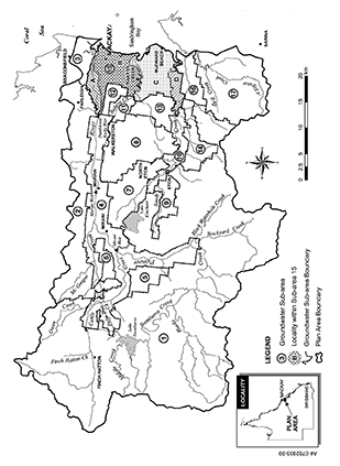
sch 2B ins 2009 SL No. 212 s 49
section 5B
sch 2C ins 2009 SL No. 212 s 49
section 7(2)
Node | Location |
A | Pioneer River at a northerly projection of the common boundary of lot 2 on RP711122 and lot 1 on RP709234 where the common boundary intersects the Pioneer River |
B | Pioneer River at Mirani Weir tailwater gauging station (AMTD 45.7km) |
C | Pioneer River at Sarich’s gauging station (AMTD 57.7km) |
D | Teemburra Creek at Teemburra Dam tailwater gauging station (AMTD 20.2km) |
E | McGregor Creek at the regulating weir on the creek (AMTD 0.7km) |
F | Cattle Creek at Gargett gauging station (AMTD 11.0km) |
G | Palm Tree Creek at its confluence with Cattle Creek (AMTD 0.0km) |
H | Cattle Creek upstream of the outlet of the Tannallo pipeline (AMTD 21.2km) |
I | Finch Hatton Creek at its confluence with Cattle Creek (AMTD 0.0km) |
Node | Location |
1 | Cattle Creek Pinnacle area |
2 | Cattle Creek Pinnacle area near its confluence with Owens Creek |
3 | Palm Tree Creek |
4 | Cattle Creek Gargett area |
5 | Septimus area |
6 | Barkers Creek area |
7 | McGregor Creek |
8 | McGregor Creek east of the Mt Ossa Road crossing |
9 | Mirani West area |
10 | De Moleyns Lagoon area |
11 | Kinchant Dam area |
12 | Pioneer River north of the Marian weir |
13 | Mackay area east of the Bruce Highway and south of the Pioneer River |
14 | Lower Bakers Creek at UTM coordinates 725777E 7655714N MGA Zone 55 |
15 | Lower Bakers Creek at UTM coordinates 725926E 7654974N MGA Zone 55 |
16 | Lower MacLennan Creek |
17 | Upper Rocky Creek area |
18 | Coastal area south of Lower Bakers Creek |
19 | Coastal area north of McEwans Beach |
20 | Estuary of Sandy Creek |
21 | Sandringham Creek in the Bruce Highway area |
22 | Alligator Creek in the Bruce Highway area |
23 | Sandringham Lagoon |
24 | Marwood area |
25 | Sandy Creek in the Homebush area |
26 | Sandy Creek near its confluence with Ross Creek |
27 | Sandy Creek at Homebush gauging station (AMTD 32.7km) |
28 | Sandy Creek at a line perpendicular to the bank of the creek at UTM coordinates 717324E 7647415N MGA Zone 55, adjacent to lot 2 on RP703266 |
sch 3 sub 2009 SL No. 212 s 49
sections 20 and 20A
Table 1 Column 1 Column 2 Column 3 Column 4 Node August–November 50% daily flow December–March 50% daily flow April–July 50% daily flow B 92 671 404 C 9 146 100 D 2 20 10 E 4 11 18 F 62 407 229 G 5 25 16 I 6 86 411At each node mentioned in table 1, column 1 minimise the extent to which the 50% daily flow stated in columns 2 to 4 of the table for each water flow season for the node is equalled or exceeded in less than 35% of the days in each water flow season for the simulation period for surface water.
2At each node mentioned in table 1, column 1, other than node I, minimise the extent to which the 50% daily flow stated in columns 2 to 4 of the table for each water flow season for the node is equalled or exceeded in more than 65% of the days in each water flow season for the simulation period for surface water.
3At each node mentioned in table 2, column 1, the percentage of the total number of days in the water flow season in the simulation period for surface water that the 50% daily flow stated for the water flow season for the node in table 1 is equalled or exceeded be at least the percentage stated in table 2.
Table 2
Column 1
Column 2
Column 3
Column 4
Node
August–November
December–March
April–July
A
16%
33%
29%
H
35%
35%
35%
4At each node mentioned in table 3, column 1, minimise the extent to which the 90% daily flow stated in columns 2 to 4 of the table for each water flow season for the node is equalled or exceeded in less than 75% of the days in each water flow season for the simulation period for surface water.
Table 3
Column 1
Column 2
Column 3
Column 4
Node
August–November 90% daily flow
December–March 90% daily flow
April–July 90% daily flow
B
18
45
118
C
0
0
8
D
1
1
3
E
0
0
0
F
14
32
73
G
1
2
6
I
0
6
4
5At each node mentioned in table 4, column 1, the percentage of the total number of days in the water flow season in the simulation period for surface water that the 90% daily flow stated for the water flow season for the node in table 3 is equalled or exceeded be at least the percentage stated in table 4.
Table 4
Column 1
Column 2
Column 3
Column 4
Node
August–November
December–March
April–July
A
64%
63%
49%
H
75%
75%
75%
6At each node mentioned in table 5, column 1, the percentage of the total number of days in the simulation period for surface water on which the daily flow is less than 1ML be between the minimum and maximum percentages stated for the node in column 2 of the table.
Table 5
Column 1
Column 2
Node
Minimum–Maximum percentage
A
0–15
B
0–15
C
0–33
D
1–32
E
3–48
F
0–16
G
0–24
H
0–16
I
13–28
7At each node mentioned in table 6, column 1—(a)minimise the extent to which the number of periods of no flow of at least 1 month but less than 3 months in the simulation period for surface water are less than the minimum or more than the maximum number stated for the node in column 2 of the table; and(b)minimise the extent to which the number of periods of no flow of at least 3 months in the simulation period for surface water are less than the minimum or more than the maximum number stated for the node in column 3 of the table.
Table 6
Column 1
Column 2
Column 3
Node
Minimum–maximum number
Minimum–maximum number
A
0–15
0–1
B
0–5
0–0
C
0–55
0–2
D
0–4
0–2
E
0–89
0–11
F
0–0
0–0
G
0–15
0–2
H
0–3
0–0
I
24–32
0–0
Table 7 Column 1 Column 2 Column 3 Column 4 Column 5 Node Mean annual flow % 1.5 year DFV % 5 year DFV % 20 year DFV % A 83 93 97 97 B 86 95 93 93 C 92 97 96 98 F 95 98 99 99 H 95 98 — — I 98 98 — —7AAt each node mentioned in table 7, column 1—
(a)the mean annual flow in the simulation period for surface water, expressed as a percentage of the mean annual flow for the pre-development flow pattern, be at least the percentage stated for the node in column 2; and
(b)the 1.5 year daily flow volume (the 1.5 year DFV), expressed as a percentage of the 1.5 year DFV for the pre-development flow pattern, be at least the percentage stated for the node in column 3; and
(c)the 5 year daily flow volume (the 5 year DFV), expressed as a percentage of the 5 year DFV for the pre-development flow pattern, be at least the percentage stated for the node in column 4; and
(d)the 20 year daily flow volume (the 20 year DFV), expressed as a percentage of the 20 year DFV for the pre-development flow pattern, be at least the percentage stated for the node in column 5.
Table 8 Column 1 Node Column 2 Annual proportional flow deviation A 1.8 B 1.7 C 1.6 F 1.68At each node mentioned in table 8, column 1, the flow regime class be maintained as late summer flow regime class.
9At each node mentioned in table 8, column 1, the annual proportional flow deviation be not more than the annual proportional flow deviation stated for the node in column 2.
10At node A, the mean wet season flow expressed as a percentage of the mean wet season flow for the pre-development flow pattern, be at least 86%.
Table 9 Column 1 Column 2 Column 3 Node Minimum–Maximum % Minimum–Maximum % 27 0–20 74–79 28 0–20 67–7511At each node mentioned in table 9, column 1—
(a)the percentage of the total number of days in the simulation period for groundwater on which the daily flow is less than 1ML be between the minimum and maximum percentages stated for the node in column 2; and
(b)the percentage of the total number of days in the simulation period for groundwater on which the daily flow is less than 50ML be between the minimum and maximum percentages stated for the node in column 3.
Table 10 Column 1 Column 2 Node Drawdown deviation (Metres) 1 0.5 2 0.5 3 0.5 4 1.0 5 5.0 6 5.0 7 3.0 8 1.2 9 5.0 10 5.0 11 1.5 12 1.1 13 0.5 14 0.6 15 0.5 16 0.5 17 1.5 18 0.8 19 0.7 20 0.5 21 0.8 22 0.6 23 2.75 24 5.0 25 1.1 26 0.512At each node mentioned in table 10, column 1, groundwater levels must not exceed the drawdown deviation stated in column 2 of the table.
Table 11 Column 1 Column 2 Column 3 Groundwater sub-area Part of groundwater sub-area Area (Hectares) 15A north of the Pioneer River influenced by the tide 265 15B south of the Pioneer River, and north of Bakers Creek, influenced by the tide 1866 15C south of Bakers Creek, and north of Sandy Creek, influenced by the tide 2313 15D south of Sandy Creek influenced by the tide 704 16 south of Sandy Creek influenced by the tide between the estuaries of Sandy Creek and Alligator Creek 67113In each part of a groundwater sub-area, described in table 11, column 2, opposite the groundwater sub-area mentioned in column 1, the part of the groundwater sub-area, expressed in hectares, between the coastline and the maximum extent of simulated seawater intrusion is less than the seawater intruded area stated in column 3.
sch 4 amd 2009 SL No. 212 s 50; 2014 SL No. 142 s 222; 2016 SL No. 216 s 146 sch 20
section 22
1For water allocations in a high class A priority group—
(a)the monthly supplemented water sharing index be at least 95%; and
(b)the extent to which the monthly supplemented water sharing index is less than 100% be minimised.
2For water allocations in a high class B priority group—
(a)the monthly supplemented water sharing index be at least 95%; and
(b)the extent to which the monthly supplemented water sharing index is less than 97% be minimised.
3For water allocations in a medium priority group—
(a)the monthly supplemented water sharing index be at least 85%; and
(b)the extent to which the monthly supplemented water sharing index is less than 90% be minimised.
4For water allocations in a risk priority group, the monthly supplemented water sharing index may be 0%.
Table 1 Column 1 Water allocation group Column 2 30% Column 3 50% Column 4 70% Class 2A 110 96 82 Class 3A 110 96 82 Class 4A 110 96 82 Class 5A 106 98 92 Class 6A 106 98 92 Class 7A 118 101 73 Class 1B 109 108 84 Class 4B 99 98 96 Class 5B 99 98 96 Class 6B 99 98 96 Class 7B 131 99 76 Class 8B 110 109 1065For a water allocation group mentioned in table 1, column 1, the 30%, 50% and 70% unsupplemented water sharing indices be at least the percentage stated for the water allocation group in columns 2 to 4.
Table 2 Column 1 Groundwater sub-area Column 2 Annual volume probability Minimum % Column 3 Annual volume probability Maximum % 4 55 60 5 51 56 6 65 70 7 47 52 8 50 55 9 33 38 10 46 51 11 48 53 12 41 46 13 49 54 14 28 33 15 44 49 16 90 956For a water allocation to take groundwater in a groundwater sub-area mentioned in table 2, column 1, the annual volume probability be at least the percentage stated opposite the sub-area in column 2, and the extent to which it is less than the percentage stated opposite the sub-area in column 3 be minimised.
sch 5 amd 2009 SL No. 212 s 51
section 40, 49M or 49N(2)
Table 1
Column 1 Water allocation group | Column 2 ML |
Class 2A | 1783 |
Class 3A | 588 |
Class 4A | 954 |
Class 5A | 1185 |
Class 6A | 867 |
Class 7A | 414 |
Class 1B | 1601 |
Class 4B | 131 |
Class 5B | 1070 |
Class 6B | 282 |
Class 7B | 1186 |
Class 8B | 2286 |
Class 2C | the nominal volume for a water allocation to take declared water in the watercourse area in groundwater sub-area 1, subcatchment 2, stated in the resource operations plan |
Class 3C | the nominal volume for a water allocation to take declared water in the watercourse area in groundwater sub-area 1, subcatchment 3, stated in the resource operations plan |
Class 4C | the nominal volume for a water allocation to take declared water in the watercourse area in groundwater sub-area 1, subcatchment 4, stated in the resource operations plan |
Class 6C | the nominal volume for a water allocation to take declared water in the watercourse area in groundwater sub-area 1 or 4, subcatchment 6, stated in the resource operations plan |
Table 2
Column 1 Water allocation group | Column 2 Annual volumetric limit ML | Column 3 Nominal volume ML |
4 | 12107 plus the annual volumetric limits for water allocations, expressed in megalitres, in the undeclared area in groundwater sub-area 4, stated in the resource operations plan | 9631 plus the nominal volumes for water licences, expressed in megalitres, in the undeclared area in groundwater sub-area 4, stated in the resource operations plan |
5 | 1275 | 1130 |
6 | 1512 plus the annual volumetric limits for water allocations, expressed in megalitres, in the undeclared area in groundwater sub-area 6, stated in the resource operations plan | 1107 plus the nominal volumes for water licences, expressed in megalitres, in the undeclared area in groundwater sub-area 6, stated in the resource operations plan |
7 | 11133 | 9269 |
8 | 4837 | 4112 |
9 | 768 | 663 |
10 | 5413 | 3478 |
11 | 2250 | 1304 |
12 | 2575 | 971 |
13 | 4159 | 3201 |
14 | 2507 | 1952 |
15 | 8704 plus the annual volumetric limits for water allocations, expressed in megalitres, in the undeclared area in groundwater sub-area 15, stated in the resource operations plan | 4413 plus the nominal volumes for water licences, expressed in megalitres, in the undeclared area in groundwater sub-area 15, stated in the resource operations plan |
16 | 188 | 181 |
sch 6 amd 2009 SL No. 212 s 52
sections 49N(1) and 49ZA(5) and schedule 10, definition complementary component
Column 1 Groundwater sub-area | Column 2 Percentage |
11 | 55 |
12 | 55 |
13 | 60 |
15A | 55 |
15B | 55 |
15C | 60 |
15D | 100 |
16 | 100 |
17 | 100 |
sch 6A ins 2009 SL No. 212 s 53
section 43
Column 1 Pump size (mm) | Column 2 Rate (litres/second) |
32 | 3 |
40 | 7 |
50 | 15 |
65 | 27 |
75 | 36 |
80 | 39 |
100 | 50 |
150 | 84 |
200 | 110 |
250 | 300 |
300 | 347 |
350 | 405 |
375 to 400 | 500 |
405 | 637 |
500 | 762 |
600 to 610 | 1000 |
660 | 1528 |
800 | 2130 |
sch 7 amd 2009 SL No. 212 s 54
sections 45 and 49Q
Column 1 Subcatchment area | Column 2 Water allocation group | Column 3 Water allocation group | Column 4 Water allocation group |
1 | — | — | Class 1B |
2 | Class 2A | Class 2C | — |
3 | Class 3A | Class 3C | — |
4 | Class 4A | Class 4C | Class 4B |
5 | Class 5A | — | Class 5B |
6 | Class 6A | Class 6C | Class 6B |
7 | Class 7A | — | Class 7B |
8 | — | — | Class 8B |
Column 1 Groundwater sub-area | Column 2 Water allocation group |
4 | 4 |
5 | 5 |
6 | 6 |
7 | 7 |
8 | 8 |
9 | 9 |
10 | 10 |
11 | 11 |
12 | 12 |
13 | 13 |
14 | 14 |
15 | 15 |
16 | 16 |
sch 8 sub 2009 SL No. 212 s 55
section 53
The Eton priority area consists of the area for which water is supplied from Kinchant Dam, or works associated with the dam, under a resource operations licence or interim resource operations licence.
The Pioneer River priority area consists of the following—(a)the part of the Pioneer River between the downstream extent of the river and the confluence of the river and Blacks Creek, including the impounded areas of Dumbleton Rocks Weir, Marian Weir and Mirani Weir (AMTD 15.5km to AMTD 66.0km);(b)the part of Blacks Creek between the confluence of the creek and the Pioneer River and the confluence of the creek and Teemburra Creek (AMTD 66.0km to AMTD 104.0km);(c)the part of Teemburra Creek between the confluence of the creek and Blacks Creek, including the impounded area of Teemburra Dam (AMTD 83.5km to AMTD 20.5km);(d)the part of Bakers Creek between the downstream extent of the creek and the Palmyra diversion channel outlet (AMTD 17.0km to AMTD 29.5km);(e)the part of McGregor Creek between the confluence of the creek and Pioneer River and the confluence of the creek and Silver Creek (AMTD 0.0km to AMTD 7.0km);(f)the part of Silver Creek between the confluence of the creek and McGregor Creek and the Silver Creek diversion channel outlet (AMTD 0.0km to AMTD 14.0km);(g)the part of Cattle Creek between the confluence of the creek and the Pioneer River and the Tannallo pipeline outlet (AMTD 0.0km to AMTD 21.1km);(h)the part of Palm Tree Creek between the confluence of the creek and Cattle Creek and the Palm Tree Creek diversion pipeline outlet (AMTD 0.0km to AMTD 7.5km).
3Upper Cattle Creek priority area
The Upper Cattle Creek priority area consists of subcatchment areas 2, 3 and 4.
The groundwater priority area consists of groundwater sub-areas 4 to 16.sch 9 s 4 ins 2009 SL No. 212 s 56
schedule 10, definitions coastline and seawater intrusion baseline
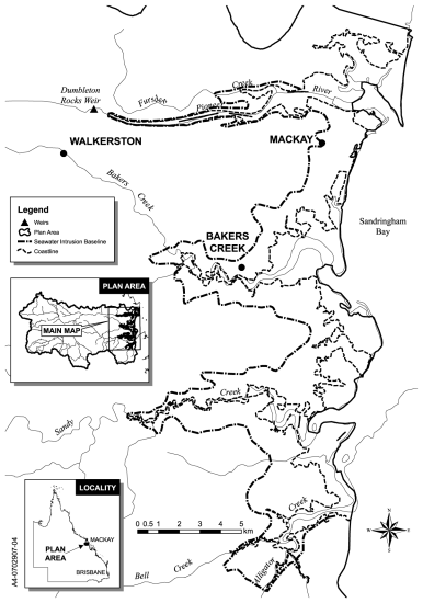
sch 9A ins 2009 SL No. 212 s 57
schedule 10, definitions domestic area A, domestic area B and domestic area C
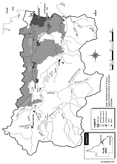
sch 9B ins 2009 SL No. 212 s 57
section 49Y
1Groundwater sub-area 11, 15, 16 or 17
(1)For the water year starting on 1 July 2009, the annual entitlement for authorisation 5, 13, or 15 (a licence) in the part of groundwater sub-area 11, 15, 16 or 17 that is seawater intruded is—(a)if the nominal entitlement stated on the licence is more than 5ML, the greater of the following—(i)the relevant annual entitlement for the licence;(ii)5ML; or(b)if the nominal entitlement stated on the licence is 5ML or less—the nominal entitlement stated on the licence.(2)In this section—relevant annual entitlement, for a licence, means the annual entitlement for the licence worked out using the formula—where—
R means the relevant annual entitlement for the licence.N means the nominal entitlement stated on the licence.A means the announced entitlement for the water year for the part of the area.

2Groundwater sub-area 11, 15, 16 or 17
(1)For the water year starting on 1 July 2010, the annual entitlement for authorisation 5, 13, or 15 (a licence) in the part of groundwater sub-area 11, 15, 16 or 17 that is seawater intruded is—(a)if the nominal entitlement stated on the licence is more than 5ML, the greater of the following—(i)the relevant annual entitlement for the licence;(ii)5ML; or(b)if the nominal entitlement stated on the licence is 5ML or less—the nominal entitlement stated on the licence.(2)In this section—relevant annual entitlement, for a licence, means the annual entitlement for the licence worked out using the formula—where—
R means the relevant annual entitlement for the licence.F means 0.6.N means the nominal entitlement stated on the licence.A means the announced entitlement for the water year for the part of the area.

3Groundwater sub-area 11, 15A or 15B
(1)For the water year starting on 1 July 2011, the annual entitlement for authorisation 5, 13, or 15 (a licence) in the part of groundwater sub-area 11, 15A or 15B, that is seawater intruded is—(a)if the nominal entitlement stated on the licence is more than 5ML, the greater of the following—(i)the relevant annual entitlement for the licence;(ii)5ML; or(b)if the nominal entitlement stated on the licence is 5ML or less—the nominal entitlement stated on the licence.(2)In this section—relevant annual entitlement, for a licence, means the annual entitlement for the licence worked out using the formula—where—
R means the relevant annual entitlement for the licence.F means 0.55.N means the nominal entitlement stated on the licence.A means the announced entitlement for the water year for the part of the area.

4Groundwater sub-area 15C, 15D, 16 or 17
(1)For the water year starting on 1 July 2011, the annual entitlement for authorisation 5, 13, or 15 (a licence) in the part of groundwater sub-area 15C, 15D, 16 or 17 that is seawater intruded is—(a)if the nominal entitlement stated on the licence is more than 5ML, the greater of the following—(i)the relevant annual entitlement for the licence;(ii)5ML; or(b)if the nominal entitlement stated on the licence is 5ML or less—the nominal entitlement stated on the licence.(2)In this section—relevant annual entitlement, for a licence, means the annual entitlement for the licence worked out using the formula—where—
R means the relevant annual entitlement for the licence.F means 0.6.N means the nominal entitlement stated on the licence.A means the announced entitlement for the water year for the part of the area.

5Groundwater sub-area 11, 15, 16 or 17—electrical conductivity of less than 1500µS/cm
For the water year starting on 1 July 2012, the annual entitlement for authorisation 5, 13, or 15 (a licence) in the part of groundwater sub-area 11, 15, 16 or 17 that is seawater intruded where the electrical conductivity of groundwater is less than 1500µS/cm is—(a)if the nominal entitlement stated on the licence is 20ML or more, the greater of the following—(i)20 multiplied by the announced entitlement for the water year for the part of the area;(ii)5ML; or(b)if the nominal entitlement stated on the licence is less than 20ML but more than 5ML, the greater of the following—(i)the nominal entitlement stated on the licence multiplied by the announced entitlement for the water year for the part of the area;(ii)5ML; or(c)if the nominal entitlement stated on the licence is 5ML or less—the nominal entitlement stated on the licence.
6Groundwater sub-area 11, 15, 16 or 17—electrical conductivity of 1500µS/cm or more
(1)For the water year starting on 1 July 2012, the annual entitlement for authorisation 5, 13, or 15 (a licence) in the part of groundwater sub-area 11, 15, 16 or 17 that is seawater intruded where the electrical conductivity of groundwater is 1500µS/cm or more is 0.(2)However, if the water taken under the licence is for public health purposes, the annual entitlement is—(a)if the nominal entitlement stated on the licence is 20ML or more, the greater of the following—(i)20 multiplied by the announced entitlement for the water year for the part of the area;(ii)5ML; or(b)if the nominal entitlement stated on the licence is less than 20ML but more than 5ML, the greater of the following—(i)the nominal entitlement stated on the licence multiplied by the announced entitlement for the water year for the part of the area;(ii)5ML; or(c)if the nominal entitlement stated on the licence is 5ML or less—the nominal entitlement stated on the licence.
7Groundwater sub-area 11, 15, 16 or 17—electrical conductivity of less than 1500µS/cm
For the water year starting on 1 July 2013, the annual entitlement for authorisation 5, 13, or 15 (a licence) in the part of groundwater sub-area 11, 15, 16 or 17 that is seawater intruded where the electrical conductivity of groundwater is less than 1500µS/cm is—(a)if the nominal entitlement stated on the licence is 20ML or more, the greater of the following—(i)20 multiplied by the announced entitlement for the water year for the part of the area;(ii)5ML; or(b)if the nominal entitlement stated on the licence is less than 20ML but more than 5ML, the greater of the following—(i)the nominal entitlement stated on the licence multiplied by the announced entitlement for the water year for the part of the area;(ii)5ML; or(c)if the nominal entitlement stated on the licence is 5ML or less—the nominal entitlement stated on the licence.
8Groundwater sub-area 11, 15, 16 or 17—electrical conductivity of 1500µS/cm or more
(1)For the water year starting on 1 July 2013, the annual entitlement for authorisation 5, 13, or 15 (a licence) in the part of groundwater sub-area 11, 15, 16 or 17 that is seawater intruded where the electrical conductivity of groundwater is 1500µS/cm or more is 0.(2)However, if the water taken under the licence is for public health purposes, the annual entitlement is—(a)if the nominal entitlement stated on the licence is more than 5ML—5ML; or(b)if the nominal entitlement stated on the licence is 5ML or less—the nominal entitlement stated on the licence.
sch 9C ins 2009 SL No. 212 s 57
section 3
1.5 year daily flow volume means the daily flow that has a 67% probability of being reached at least once a year.
5 year daily flow volume means the daily flow that has a 20% probability of being reached at least once a year.
20 year daily flow volume means the daily flow that has a 5% probability of being reached at least once a year.
µS means micro-siemens.
sch 10 def µS ins 2009 SL No. 212 s 58(2)
AMTD means the adopted middle thread distance which is the distance in kilometres, measured along the middle of a watercourse, that a specific point in the watercourse is from the watercourse’s mouth or junction with the main watercourse.
announced entitlement, for a water year, means an announced entitlement for the water year decided by the chief executive under section 49Z.
sch 10 def announced entitlement ins 2009 SL No. 212 s 58(2)
annual entitlement, for authorisation 5, 8, 10, 12, 13 or 15, means the volume of water that may be taken under the authorisation during a particular water year.
sch 10 def annual entitlement ins 2009 SL No. 212 s 58(2)
annual proportional flow deviation means the statistical measure of changes to flow season and volume in the simulation period for surface water calculated using the formula for annual proportional flow deviation described in Technical Report 5 of ‘Fitzroy Basin Water Allocation and Management Planning Technical Reports’ published by the department.
A copy of the reports is available for inspection on the department’s website.
sch 10 def annual proportional flow deviation amd 2009 SL No. 212 s 58(3)
annual volume probability, for a group of water allocations to take groundwater, means the percentage of years in the simulation period for groundwater in which the volume of water that may be taken by the group is at least the total of the nominal volumes for the allocations in the group.
sch 10 def annual volume probability ins 2009 SL No. 212 s 58(2)
annual volumetric limit, for a water entitlement, means the maximum volume of water that may be taken under the entitlement in a water year.
authorisation—
(a)generally, means a licence, permit or other authority to take or interfere with water under the Act or the repealed Act, other than a permit for stock or domestic purposes; or
(b)for part 5, division 5—see section 31.
sch 10 def authorisation sub 2009 SL No. 212 s 58(1)–(2)
authorisation 1 means an authorisation to take groundwater, in force immediately before the plan amendment day, in groundwater sub-area 4, 5, 6, 7, 8, 9, 10 or 14, other than a water licence that was an in conjunction water licence to take groundwater or standby water licence to take groundwater.
sch 10 def authorisation 1 ins 2009 SL No. 212 s 58(2)
authorisation 2 means a water licence to take groundwater that was an in conjunction water licence to take groundwater or standby water licence to take groundwater, other than authorisation 13.
sch 10 def authorisation 2 ins 2009 SL No. 212 s 58(2)
authorisation 3 means an authorisation under section 49I(2) for continuing to take groundwater in the part of the undeclared area in groundwater sub-area 4 or 6 using the works mentioned in the section.
sch 10 def authorisation 3 ins 2009 SL No. 212 s 58(2)
authorisation 5 means a water licence to take groundwater, in force immediately before the plan amendment day, in the part of groundwater sub-area 11, 15 or 16 that is seawater intruded, other than authorisation 13.
sch 10 def authorisation 5 ins 2009 SL No. 212 s 58(2)
authorisation 6 means a water licence to take groundwater, in force immediately before the plan amendment day, in the part of groundwater sub-area 15D or 16 that is not seawater intruded.
sch 10 def authorisation 6 ins 2009 SL No. 212 s 58(2)
authorisation 7 means a water licence to take groundwater, in force immediately before the plan amendment day, in the part of groundwater sub-area 11, 15A, 15B or 15C that is not seawater intruded, other than the complementary component of the licence.
sch 10 def authorisation 7 ins 2009 SL No. 212 s 58(2)
authorisation 8 means a water licence to take groundwater comprising the available component of authorisation 7.
sch 10 def authorisation 8 ins 2009 SL No. 212 s 58(2)
authorisation 9 means a water licence to take groundwater, in force immediately before the plan amendment day, in groundwater sub-area 12 or 13, other than the complementary component of the licence.
sch 10 def authorisation 9 ins 2009 SL No. 212 s 58(2)
authorisation 10 means a water licence to take groundwater comprising the available component of authorisation 9.
sch 10 def authorisation 10 ins 2009 SL No. 212 s 58(2)
authorisation 11 means a water licence to take groundwater, commonly known as water licence 20155L, in force immediately before the plan amendment day, other than the complementary component of the licence.
sch 10 def authorisation 11 ins 2009 SL No. 212 s 58(2)
authorisation 12 means a water licence to take groundwater comprising the complementary component of authorisation 11.
sch 10 def authorisation 12 ins 2009 SL No. 212 s 58(2)
authorisation 13 means a water licence to take groundwater that was an in conjunction water licence to take groundwater, or standby water licence to take groundwater, in the part of groundwater sub-area 15, 16 or 17 that is seawater intruded.
sch 10 def authorisation 13 ins 2009 SL No. 212 s 58(2)
authorisation 15 means a water licence to take groundwater for a purpose other than aquaculture purposes, in force immediately before the plan amendment day, in the part of groundwater sub-area 17 that is seawater intruded.
sch 10 def authorisation 15 ins 2009 SL No. 212 s 58(2)
authorisation 16 means a water licence, commonly known as either of the following, to take groundwater—
(a)water licence 85040L;
(b)water licence 408846.
sch 10 def authorisation 16 ins 2009 SL No. 212 s 58(2)
sub 2014 Act No. 29 s 160A
available component, of authorisation 7 or 9, means—
(a)for authorisation 7 or 9 mentioned in section 49N(1)(e)(i)—0; or
(b)for authorisation 7 or 9 mentioned in section 49N(1)(e)(ii)—the difference between the precomplementary component nominal entitlement for the authorisation and the annual volumetric limit for the allocation.
sch 10 def available component ins 2009 SL No. 212 s 58(2)
baseflow means the part of streamflow derived from the natural discharge of groundwater into a watercourse, lake or spring.
sch 10 def baseflow ins 2009 SL No. 212 s 58(2)
coastline means the line marked as the coastline on the map in schedule 9A.
sch 10 def coastline ins 2009 SL No. 212 s 58(2)
complementary component, of a water licence to take groundwater, means—
(a)for authorisation 7 or 9 for taking groundwater in a groundwater sub-area mentioned in schedule 6A, column 1—the volume worked out using the formula—where—
C means the complementary component.N means the nominal entitlement stated on the licence immediately before the plan amendment day.n means the number stated in schedule 6A, column 2, opposite the groundwater sub-area mentioned in column 1; or

(b)for authorisation 11—4200ML.
sch 10 def complementary component ins 2009 SL No. 212 s 58(2)
conditional licence means a water licence—
(a)to take water from unsupplemented stream flows for irrigation purposes; and
(b)that includes a condition allowing the taking only if the daily flow at a place in the Pioneer River, Cattle Creek or Owens Creek, stated in the licence, is at least the volume stated in the licence.
constructing authority has the meaning given in the Acquisition of Land Act 1967, section 2.
sch 10 def constructing authority ins 2009 SL No. 212 s 58(2)
daily flow, for a place, means the volume of water that flows past the place in a day.
50% daily flow, for a water flow season, means the flow in megalitres that is equalled or exceeded on 50% of the days in the season in the simulation period for surface water for the pre-development flow pattern.
sch 10 def 50% daily flow amd 2009 SL No. 212 s 58(3)
90% daily flow, for a water flow season, means the flow in megalitres that is equalled or exceeded on 90% of the days in the season in the simulation period for surface water for the pre-development flow pattern.
sch 10 def 90% daily flow amd 2009 SL No. 212 s 58(3)
daily volumetric limit, for a water entitlement, means the maximum volume of water that may be taken under a water entitlement in a day.
sch 10 def daily volumetric limit ins 2009 SL No. 212 s 58(2)
declared water see section 5B.
sch 10 def declared water ins 2009 SL No. 212 s 58(2)
domestic area means domestic area A, domestic area B or domestic area C.
sch 10 def domestic area ins 2009 SL No. 212 s 58(2)
domestic area A means the area shown as domestic area A on the map in schedule 9B.
sch 10 def domestic area A ins 2009 SL No. 212 s 58(2)
domestic area B means the area shown as domestic area B on the map in schedule 9B.
sch 10 def domestic area B ins 2009 SL No. 212 s 58(2)
domestic area C means the area shown as domestic area C on the map in schedule 9B.
sch 10 def domestic area C ins 2009 SL No. 212 s 58(2)
drawdown means the actual or simulated lowering of the groundwater level in a water bore that is caused by pumping.
sch 10 def drawdown ins 2009 SL No. 212 s 58(2)
drawdown deviation means the drawdown below the June 2003 level that must not be exceeded for more than 365 consecutive days.
sch 10 def drawdown deviation ins 2014 SL No. 142 s 223(2)
Eton priority area see schedule 9, section 1.
sch 10 def Eton priority area ins 2009 SL No. 212 s 58(2)
Eton water supply scheme means the area consisting of the Eton priority area.
sch 10 def Eton water supply scheme ins 2009 SL No. 212 s 58(2)
existing works means works that—
(a)allow the taking of water; and
(b)either—(i)were in existence on 20 September 2000; or(ii)were started, but not completed by 20 September 2000 and—(A)if a variation to a moratorium notice was granted for the works under section 42A of the Act—have been, or are being, completed in accordance with the moratorium notice, as varied; or(B)otherwise—were completed by 30 November 2001.
flow regime class means the measure of flow regime seasonality worked out using the method stated in Haines, A.T., Finlayson, B.L. and McMahon, T.A., ‘A global classification of river regimes. Applied Geography, 1988’.
food chain means a series of organisms each of which is the food of the next member of the chain.
fresh groundwater means groundwater that has—
(a)low concentrations of salt and other impurities; and
(b)an electrical conductivity of less than 1500µS/cm.
sch 10 def fresh groundwater ins 2009 SL No. 212 s 58(2)
groundwater means underground water.
sch 10 def groundwater ins 2009 SL No. 212 s 58(2)
sub 2016 SL No. 216 s 146 sch 20
groundwater-dependent ecosystem means a biological ecosystem that is wholly or partly dependent on groundwater, including the following—
(a)an aquifer, baseflow or wetland ecosystem;
(b)an estuarine or near-shore marine ecosystem;
(c)a riparian vegetation ecosystem;
(d)a terrestrial vegetation ecosystem.
sch 10 def groundwater-dependent ecosystem ins 2009 SL No. 212 s 58(2)
groundwater management area means the groundwater management area under section 5A(1).
sch 10 def groundwater management area ins 2009 SL No. 212 s 58(2)
groundwater sub-area means a groundwater sub-area under section 5A(2).
sch 10 def groundwater sub-area ins 2009 SL No. 212 s 58(2)
groundwater sub-area 15A means the locality in groundwater sub-area 15 shown as ‘A’ on the map in schedule 2B.
sch 10 def groundwater sub-area 15A ins 2009 SL No. 212 s 58(2)
groundwater sub-area 15B means the locality in groundwater sub-area 15 shown as ‘B’ on the map in schedule 2B.
sch 10 def groundwater sub-area 15B ins 2009 SL No. 212 s 58(2)
groundwater sub-area 15C means the locality in groundwater sub-area 15 shown as ‘C’ on the map in schedule 2B.
sch 10 def groundwater sub-area 15C ins 2009 SL No. 212 s 58(2)
groundwater sub-area 15D means the locality in groundwater sub-area 15 shown as ‘D’ on the map in schedule 2B.
sch 10 def groundwater sub-area 15D ins 2009 SL No. 212 s 58(2)
hyporheic zone means the zone in which an exchange between surface water and groundwater occurs.
sch 10 def hyporheic zone ins 2009 SL No. 212 s 58(2)
in conjunction water licence—
1In conjunction water licence means a water licence to take or interfere with unsupplemented water that—(a)was in force immediately before the plan amendment day: and(b)stated a maximum area that may be irrigated by taking or interfering with unsupplemented water under the licence; and(c)immediately before 16 June 2005, included a condition authorising the taking of a combination of unsupplemented water and surface water from the Eton water supply scheme.
2In conjunction water licence means a water licence to take groundwater that—(a)was in force immediately before the plan amendment day; and(b)stated a nominal entitlement for taking groundwater; and(c)immediately before 16 June 2005, included a condition authorising the total volume of surface water taken from the Eton water supply scheme and groundwater taken in a water year under the licence to be no more than the nominal entitlement stated on the licence.Example of a condition included on an in conjunction water licence to take groundwater—
a condition authorising the taking of groundwater in conjunction with the channel supply for the Eton water supply scheme
sch 10 def in conjunction water licence ins 2009 SL No. 212 s 58(2)
IQQM computer program means the department’s Integrated Quantity and Quality Modelling computer program, and associated statistical analysis and reporting programs, that simulate daily stream flows, flow management, storages, releases, instream infrastructure, water diversions, water demands and other hydrologic events in the plan area.
June 2003 level mean the actual or simulated groundwater level in a water bore on 30 June 2003.
sch 10 def June 2003 level ins 2009 SL No. 212 s 58(2)
late summer flow regime class see the Pioneer Valley Water Resource Plan Environmental Flow Report, December 2001.
A copy of the report may be inspected at the department’s head office, Brisbane or on the department’s website.
level 1 drawdown deviation ...
sch 10 def level 1 drawdown deviation ins 2009 SL No. 212 s 58(2)
om 2014 SL No. 142 s 223(1)
level 2 drawdown deviation ...
sch 10 def level 2 drawdown deviation ins 2009 SL No. 212 s 58(2)
om 2014 SL No. 142 s 223(1)
mean annual flow means the total volume of flow in the simulation period for surface water divided by the number of years in the simulation period for surface water.
sch 10 def mean annual flow amd 2009 SL No. 212 s 58(3)
mean wet season flow means the total volume of flow during the months of January to March in the simulation period for surface water divided by the number of years in the simulation period for surface water.
sch 10 def mean wet season flow amd 2009 SL No. 212 s 58(3)
MGA means Map Grid of Australia 1994 mentioned in the ‘Geocentric datum of Australia technical manual’ published by the Intergovernmental Committee on Surveying and Mapping.
At the plan amendment day, the manual could be inspected on the committee’s website at <www.icsm.gov.au/icsm/gda/gdatm/>.
sch 10 def MGA ins 2009 SL No. 212 s 58(2)
monthly supplemented water sharing index, for water allocations in a particular priority group, means the percentage of months in the simulation period for surface water in which the allocations are fully supplied.
sch 10 def monthly supplemented water sharing index amd 2009 SL No. 212 s 58(3)
monthly volumetric limit means the maximum volume of water that may be taken under a water entitlement in a month.
node see section 7.
nominal entitlement see the Water Regulation 2016, section 28.
sch 10 def nominal entitlement ins 2009 SL No. 212 s 58(2)
amd 2016 SL No. 216 s 146 sch 20
nominal volume ...
sch 10 def nominal volume om 2009 SL No. 212 s 58(1)
period of no flow, for a node, means a period in which the flow of water in the watercourse at the node is less than 1ML a day.
Pioneer subartesian area means the Pioneer subartesian area on plan AP10057.
sch 10 def Pioneer subartesian area ins 2009 SL No. 212 s 58(2)
amd 2016 SL No. 216 s 146 sch 20
plan amendment day means the day this definition commences.
sch 10 def plan amendment day ins 2009 SL No. 212 s 58(2)
plan area means the area shown as the plan area on the map in schedule 1.
sch 10 def plan area ins 2009 SL No. 212 s 58(2)
plan of survey has the meaning given by the Land Title Act 1994, schedule 2.
sch 10 def plan of survey ins 2009 SL No. 212 s 58(2)
precomplementary component nominal entitlement, for authorisation 7 or 9, means the nominal entitlement stated on the authorisation before the complementary component of the authorisation is worked out.
sch 10 def precomplementary component nominal entitlement ins 2009 SL No. 212 s 58(2)
pre-development flow pattern means the pattern of water flows, during the simulation period for surface water, decided by the chief executive using the IQQM computer program as if—
(a)there were no dams or other water infrastructure in the plan area; and
(b)no water was taken under authorisations in the plan area.
sch 10 def pre-development flow pattern amd 2009 SL No. 212 s 58(3)
priority area see section 53.
public health purposes includes ablutions and toilets.
sch 10 def public health purposes ins 2009 SL No. 212 s 58(2)
quarterly volumetric limit, for a water entitlement, means the maximum volume of water that may be taken under a water entitlement in any 3 consecutive months.
sch 10 def quarterly volumetric limit ins 2009 SL No. 212 s 58(2)
registered means registered in the freehold land register.
sch 10 def registered ins 2009 SL No. 212 s 58(2)
related development permit, for an authorisation, means the development permit for the works for taking water under the authorisation.
relevant groundwater-dependent ecosystem means a groundwater-dependent ecosystem that is a riparian vegetation ecosystem or terrestrial vegetation ecosystem.
sch 10 def relevant groundwater-dependent ecosystem ins 2009 SL No. 212 s 58(2)
resource operations plan means the resource operations plan to implement this plan.
See the Act, section 1266.
sch 10 def resource operations plan amd 2016 SL No. 216 s 146 sch 20
riparian vegetation ecosystem means a vegetation ecosystem, other than a terrestrial vegetation ecosystem, that includes groundwater-dependent vegetation growing on, or immediately adjacent to, the banks of a lagoon or stream in the plan area.
sch 10 def riparian vegetation ecosystem ins 2009 SL No. 212 s 58(2)
seawater intrusion means the ingress of seawater—
(a)from the coast or an estuary into an aquifer in which there is fresh groundwater; and
(b)caused by human activities.
sch 10 def seawater intrusion ins 2009 SL No. 212 s 58(2)
seawater intrusion baseline means a line—
(a)marked as the seawater intrusion baseline on the map in schedule 9A; and
(b)representing the seawater intrusion front as at the plan amendment day.
sch 10 def seawater intrusion baseline ins 2009 SL No. 212 s 58(2)
seawater intrusion front means a line representing the extent of seawater intrusion into an aquifer where the electrical conductivity of groundwater in the aquifer is at least 1500µS/cm.
sch 10 def seawater intrusion front ins 2009 SL No. 212 s 58(2)
simulated mean annual diversion, for an authorisation or a group of authorisations, means the total volume of water simulated to have been taken under the authorisation or authorisations, if the authorisation or authorisations were in existence for the whole of the simulation period for surface water, divided by the number of years in the simulation period for surface water.
sch 10 def simulated mean annual diversion amd 2009 SL No. 212 s 58(3)
simulation period means the period—
(a)for surface water—from 1 July 1900 to 30 June 1996; or
(b)for groundwater—from 1 July 1900 to 30 June 2003.
sch 10 def simulation period sub 2009 SL No. 212 s 58(1)–(2)
standby water licence—
1Standby water licence means a water licence to take or interfere with unsupplemented water that—(a)was in force immediately before the plan amendment day: and(b)stated a maximum area that may be irrigated by taking or interfering with water under the licence; and(c)immediately before 16 June 2005, included a condition authorising the taking of unsupplemented water only if surface water from the Eton water supply scheme is unavailable.Example of a condition included on a standby water licence to take unsupplemented water—
a condition that unsupplemented water may be taken under the licence only if surface water normally taken from the Eton water supply scheme is not available
2Standby water licence means a water licence to take groundwater that—(a)was in force immediately before the plan amendment day: and(b)stated a nominal entitlement for taking groundwater; and(c)immediately before 16 June 2005, included a condition authorising the taking of groundwater only if surface water from the Eton water supply scheme is unavailable.
sch 10 def standby water licence ins 2009 SL No. 212 s 58(2)
started, for existing works, means—
(a)construction of the works had physically started or, if construction had not physically started, a contract had been entered into to start construction, and construction had started, by 20 September 2000; and
(b)an independently verifiable construction program existed for progressive construction towards completion of the works; and
(c)detailed design plans existed showing, among other things, the extent of the works; and
(d)if a permit under the Local Government Act 1993, section 940 was required for the works—the permit had been issued; and
(e)if a development permit was required for the works—the permit had been given.
stock purposes, in relation to taking water, means watering stock of a number that would normally be depastured on the land.
subcatchment area see section 5(1).
supplemented water means water supplied under an interim resource operations licence, resource operations licence or other authority to operate water infrastructure.
surface water see section 8(a).
sch 10 def surface water ins 2009 SL No. 212 s 58(2)
terrestrial vegetation ecosystem means a vegetation ecosystem, other than a riparian vegetation ecosystem.
sch 10 def terrestrial vegetation ecosystem ins 2009 SL No. 212 s 58(2)
undeclared area means the area, comprising the part of groundwater sub-area 1, 2, 3, 4, 6 or 15, that is not the Pioneer subartesian area.
sch 10 def undeclared area ins 2009 SL No. 212 s 58(2)
unsupplemented water means surface water that is not supplemented water.
sch 10 def unsupplemented water amd 2009 SL No. 212 s 58(4)
30% unsupplemented water sharing index, for a group of authorisations, means the total volume of water simulated to have been taken annually under the authorisations in at least 30% of years in the simulation period for surface water, if the authorisations were in existence for the whole of the simulation period for surface water, expressed as a percentage of the simulated mean annual diversion for the authorisations.
sch 10 def 30% unsupplemented water sharing index amd 2009 SL No. 212 s 58(3)
50% unsupplemented water sharing index, for a group of authorisations, means the total volume of water simulated to have been taken annually under the authorisations in at least 50% of years in the simulation period for surface water, if the authorisations were in existence for the whole of the simulation period for surface water, expressed as a percentage of the simulated mean annual diversion for the authorisations.
sch 10 def 50% unsupplemented water sharing index amd 2009 SL No. 212 s 58(3)
70% unsupplemented water sharing index, for a group of authorisations, means the total volume of water simulated to have been taken annually under the authorisations in at least 70% of years in the simulation period for surface water, if the authorisations were in existence for the whole of the simulation period for surface water, expressed as a percentage of the simulated mean annual diversion for the authorisations.
sch 10 def 70% unsupplemented water sharing index amd 2009 SL No. 212 s 58(3)
UTM means a system known as Universal Transverse Mercator used to project a spherical earth onto a flat map.
sch 10 def UTM ins 2009 SL No. 212 s 58(2)
voluntary acquisition, of land, means acquisition of land, other than under the Acquisition of Land Act 1967, with the agreement of the owner of the land.
sch 10 def voluntary acquisition ins 2009 SL No. 212 s 58(2)
water allocation group means—
(a)for a water allocation group for water allocations to take surface water—a water allocation group mentioned in schedule 8, part 1; or
(b)for a water allocation group for water allocations to take groundwater—a water allocation group mentioned in schedule 8, part 2.
sch 10 def water allocation group sub 2009 SL No. 212 s 58(1)–(2)
water bore means a subartesian bore.
sch 10 def water bore ins 2009 SL No. 212 s 58(2)
watercourse area means the area shown as the watercourse area on the map in schedule 2C.
sch 10 def watercourse area ins 2009 SL No. 212 s 58(2)
water flow season means any of the following periods—
(a)the period in a year from 1 August to 30 November (August–November);
(b)the period from 1 December in a year to 31 March in the following year (December–March);
(c)the period in a year from 1 April to 31 July (April–July).
waterhole means a part of a watercourse that contains water after the watercourse ceases to flow, other than a part of a watercourse that is within the storage area of a dam on the watercourse.
water supply scheme means a scheme for the supply of water under an interim resource operations licence, a resource operations licence or another authority to manage water entitlements.