


This plan may be cited as the Water Plan (Mary Basin) 2024.
The purposes of this plan are to—(a)define the availability of water to which this plan applies; and(b)provide a framework for sustainably managing water to which this plan applies; and(c)identify priorities and mechanisms for dealing with the future water requirements in the plan area; and(d)regulate the taking of, and interference with, surface water, and the taking of underground water, to which this plan applies; and(e)provide a framework for establishing and managing water allocations for surface water to which this plan applies; and(f)provide access to water resources to help the traditional owners of the plan area achieve their economic, social and cultural aspirations; and(g)provide a framework for reversing, where practicable, the degradation of natural ecosystems caused by the taking of, or interference with, water to which this plan applies.
The dictionary in schedule 8 defines particular words used in this plan.
Surface water is water in a watercourse, lake or spring.
5Water to which plan applies—Act, s 43
For section 43(1)(a) of the Act, this plan applies to the following water—(a)surface water in the plan area;(b)underground water in the underground water management area.
This plan applies to the area shown as the plan area on the map in schedule 1, part 1.
7Subcatchments and water management areas
(1)The plan area is divided into subcatchments.(2)Each subcatchment is identified, by a letter, on the map in schedule 2, part 1 and is named in schedule 2, part 2.(3)A subcatchment may be referred to in this plan by its letter or by its name.(4)Each subcatchment is a water management area for schedule 4 of the Act, definition water management area, paragraph (b).(5)A water management area may be referred to in this plan by the letter or name of its subcatchment.
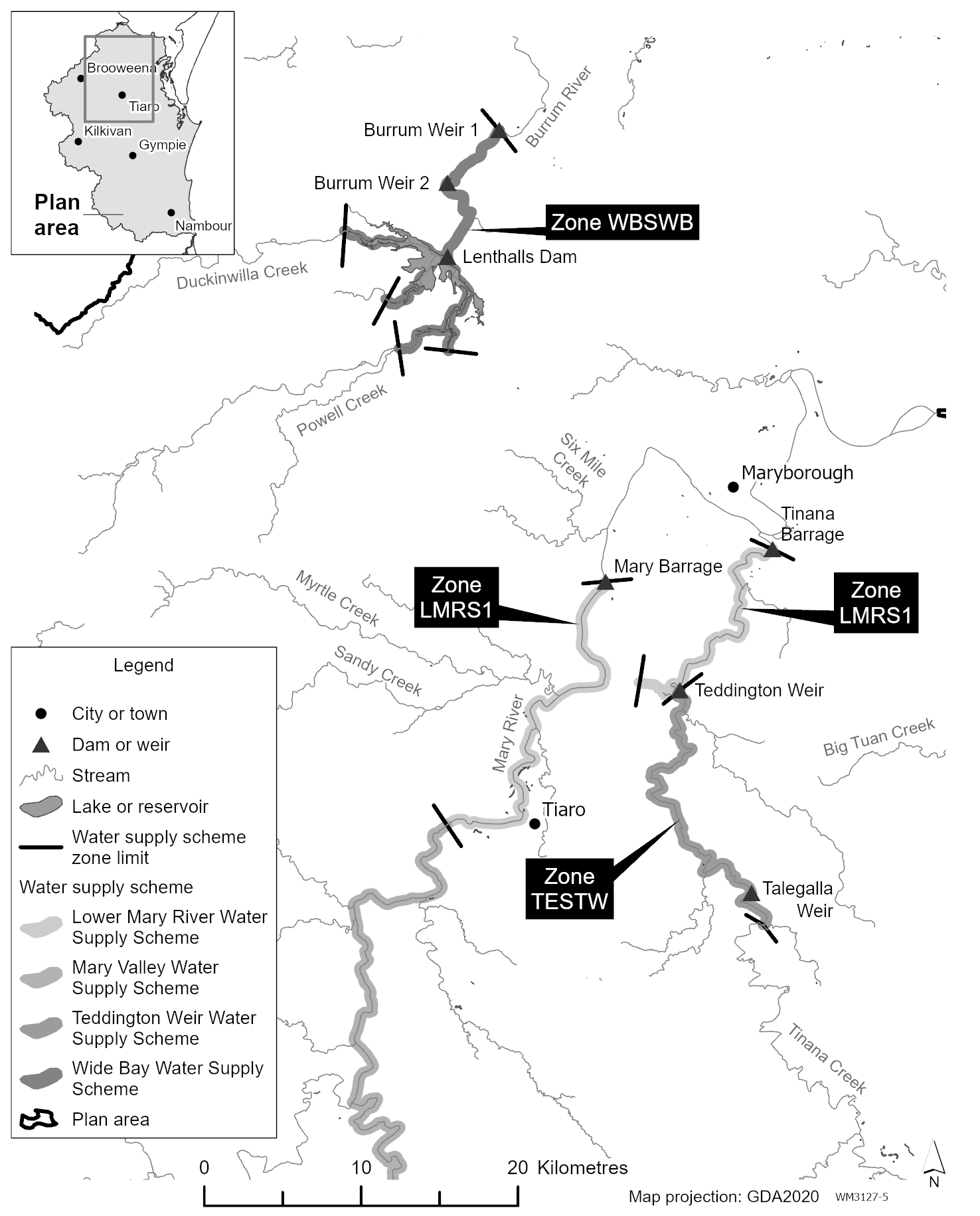
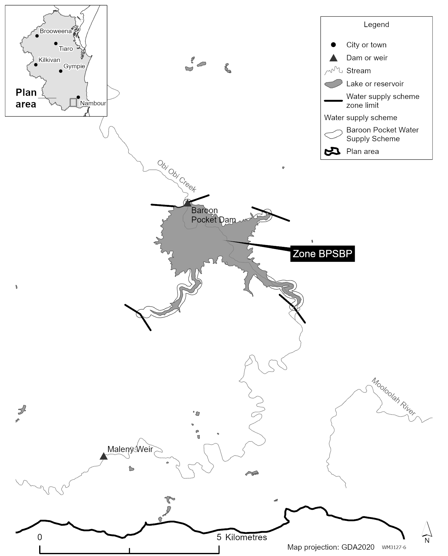
8Water supply schemes and water supply scheme zones
(1)Each part of the plan area shown as a water supply scheme on the map in schedule 3, part 1 is a water supply scheme for this plan.(2)A reference in this plan to a water supply scheme by name is a reference to the water supply scheme given that name on the map in schedule 3, part 1.(3)Each part of a water supply scheme that is shown as a water supply scheme zone on a map in schedule 3, part 2, 3 or 4 is a water supply scheme zone for—(a)this plan; and(b)the water supply scheme.(4)A reference in this plan to a water supply scheme zone by name is a reference to the water supply scheme zone given that name on a map in schedule 3, part 2, 3 or 4.
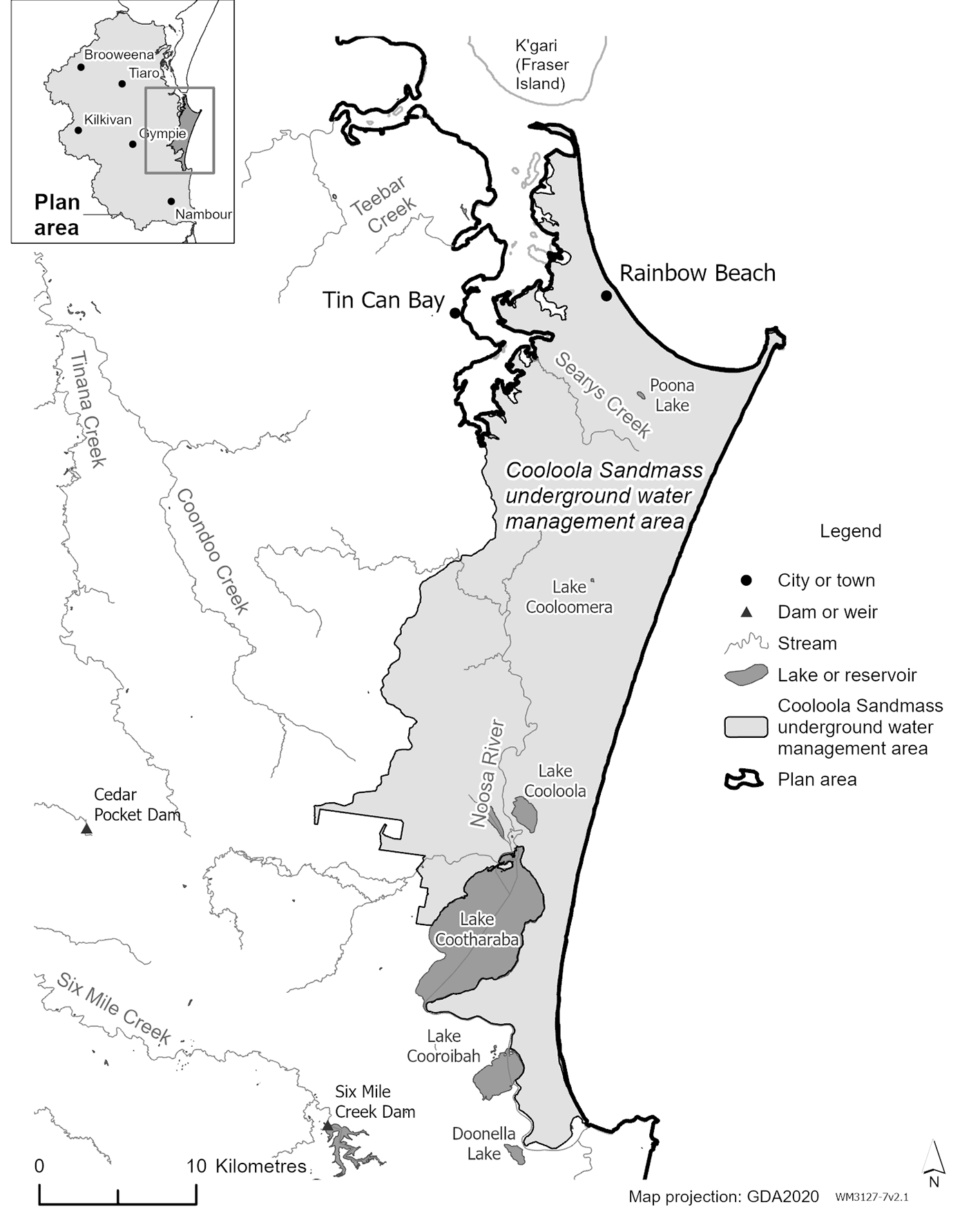
9Underground water management area
The part of the plan area shown as the Cooloola Sandmass underground water management area on the map in schedule 4 is the underground water management area.
For section 43(1)(e)(i) of the Act, a water supply scheme zone is a trading zone for water allocations to which this plan applies.
(1)A node is a point in the plan area.(2)The modelled location of each node is identified, by a number, on the map in schedule 1, part 1 and is described in schedule 1, part 2.(3)A node may be referred to in this plan by its number.(4)The actual location of each node is set by the model computer program.
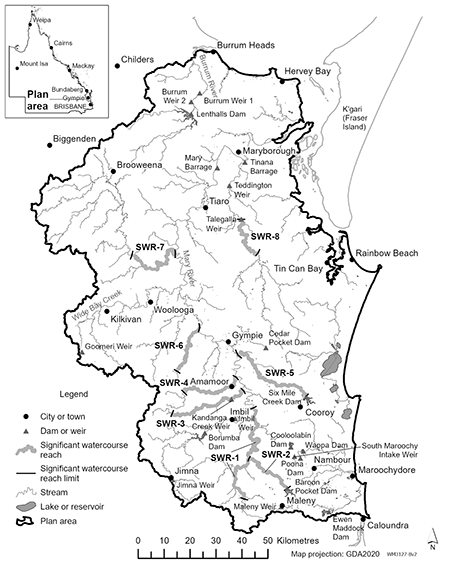
12Significant watercourse reaches
A significant watercourse reach is a part of a watercourse that—(a)is in the plan area; and(b)is shown as a significant watercourse reach on the map in schedule 5.
The exact location of the boundaries of each of the following is held in digital electronic form by the department and may be accessed at each office of the department—(a)the plan area;(b)a subcatchment;(c)a water management area;(d)a water supply scheme;(e)a water supply scheme zone;(f)the underground water management area;(g)a significant watercourse reach.The location of each office of the department is available on the department’s website.
This part states, for section 43(1)(b) of the Act, the water plan outcomes for this plan.
A water plan outcome for this plan is that water to which this plan applies is to be allocated and managed in a way that—(a)recognises the natural state of watercourses, lakes, springs and aquifers has changed because of the taking of, or interference with, water; and(b)seeks to achieve a balance between—(i)the economic water plan outcomes stated in section 16; and(ii)the social water plan outcomes stated in section 17; and(iii)the cultural water plan outcomes stated in section 18; and(iv)the environmental water plan outcomes stated in section 19; and(c)promotes improved understanding of—(i)matters affecting the flow-related, and underground water-dependent, health of ecosystems, including springs, in the plan area; and(ii)the flow-related requirements of ecosystems in the plan area; and(iii)the water required for social, spiritual, economic, environmental and cultural uses of water by the traditional owners of the plan area; and(iv)the water required to deliver social and economic benefits to communities in the plan area; and(v)the impact of climate change on water availability.
16Water plan outcomes—economic
The economic water plan outcomes for this plan are—(a)to provide for the continued effect of all water entitlements and other authorisations to take or interfere with water to which this plan applies; and(b)to protect the availability of water to which this plan applies that is water that may be taken under a water entitlement; and(c)to maintain the availability of water to which this plan applies for industries dependent on the water resources for the plan area; and(d)to provide for mechanisms that support growth in industries dependent on the water resources for the plan area, including, for example—(i)agriculture; and(ii)energy storage and generation; and(iii)tourism; and(e)to make water to which this plan applies available, and to provide for water entitlements to take or interfere with the water, to support the economic aspirations of the traditional owners of the plan area; and(f)to support the effective and efficient implementation and operation of the market in water allocations.
The social water plan outcomes for this plan are—(a)to maintain—(i)the availability of water to which this plan applies for the supply of urban water to towns and communities dependent on the water resources for the plan area; and(ii)the flows of water to which this plan applies that support water-related aesthetic, community and recreational values; and(b)to provide water to which this plan applies—(i)for stock purposes and domestic purposes in the plan area; and(ii)to meet increased demand, because of an increase in population, for the supply of urban water to towns and communities dependent on the water resources for the plan area; and(c)to make water to which this plan applies available to support the social aspirations of the traditional owners of the plan area; and(d)to manage and allocate underground water in the underground water management area to minimise seawater intrusion into the Cooloola Sandmass aquifer.
18Water plan outcomes—cultural
The cultural water plan outcomes for this plan are—(a)to make water to which this plan applies available to support the cultural aspirations of the traditional owners of the plan area; and(b)to maintain flows of water to which this plan applies that support the cultural connection between the traditional owners of the plan area, the cultural values in the plan area and the water resources for the plan area; and(c)to continue to engage with the traditional owners of the plan area to improve understanding of the cultural values, uses and aspirations in relation to water to which this plan applies; and(d)to promote continual involvement of the traditional owners of the plan area in the development, monitoring and implementation of this water plan; and(e)to maintain or provide flows of water to which this plan applies to support sites of cultural significance in the plan area, including, for example, the Wongi Waterholes; and(f)to maintain or provide flows of water to which this plan applies to support species of cultural significance, including, for example, the Mary River cod, the Australian lungfish, the Mary River turtle and the white-throated snapping turtle.
19Water plan outcomes—environmental
(1)The environmental outcomes for this plan area are—(a)to maintain, and if possible improve, flows of water to which this plan applies that support—(i)native plants and animals, and their freshwater and estuarine habitats; and(ii)long-term water quality suitable for riverine and estuarine ecosystems; and(b)to maintain, and if possible improve, the low flow regimes, of the watercourses to which this plan applies, that support ecological assets, for example—(i)riffle habitats; and(ii)the quality and persistence of waterholes; and(iii)the connectivity of watercourses required over the lifespan of native aquatic species, including to allow for opportunities for movement, spawning and recruitment of the species; and(c)to maintain the medium flow regimes and high flow regimes, of the watercourses to which this plan applies, that support ecological assets, for example—(i)river-forming processes; and(ii)riparian systems and their functions; and(iii)floodplain and wetland ecosystems; and(iv)estuarine ecosystems; and(d)to maintain, and if possible, improve, flows of freshwater to which this plan applies that support ecological processes in the following waters—(i)waters of estuaries that receive flows of water from the plan area;(ii)the marine waters of the Great Barrier Reef;(iii)the waters of the Great Sandy Strait declared Ramsar wetland; and(e)to minimise adverse environmental impacts, relating to water to which this plan applies, caused by the operation of infrastructure in the plan area; andExamples of adverse environmental impacts—
degradation of water quality, a reduction in habitats(f)for the Mooloolah River, the Noosa River, the Maroochy River and their tributaries—to minimise change to the natural flow regime that supports the rivers and tributaries; and(g)for the freshwater reaches of the Mary River and its tributaries—to maintain, and if possible, improve—(i)the low flow regime of the freshwater reaches; and(ii)the flow-related habitat requirements of ecological assets in the freshwater reaches; andExamples of ecological assets for subparagraph (ii)—
Mary River cod, Australian lungfish, Mary River turtle, white-throated snapping turtle(h)for the Burrum River and its tributaries, downstream of Lenthalls Dam—to support freshwater flows that are necessary—(i)for estuarine processes; and(ii)to reduce hypersaline conditions in the upper Burrum River estuary; and(i)for the underground water management area—to maintain, and if possible improve, the availability and quality of underground water to which this plan applies to support ecosystems dependent on the underground water.Examples of ecosystems for paragraph (i)—
•wetlands•terrestrial vegetation communities•ecosystems of which Searys Creek or Teewah Creek form a part•ecosystems of which springs form a part(2)In this section—ecological assets include a species, a group of species, a biological function, an ecosystem and a place of natural value that is dependent on attributes of a flow regime to support the asset’s long-term viability.flow regime means the entire range of flows at a point in a watercourse including variations in the watercourse height, discharge, seasonality, annual variability and event duration.flow-related habitat requirements, of an ecological asset, means the hydraulic or physical attributes of a flow regime that are required—(a)for a particular biological process or response to happen in relation to the asset; or(b)to maintain the long-term biological integrity of the asset.movement opportunities of species or groups of speciesfreshwater reaches, of the Mary River and its tributaries, means—(a)the Mary River and its tributaries, upstream of the Mary River Barrage; and(b)Tinana Creek, upstream of Tinana Barrage.Great Sandy Strait declared Ramsar wetland means Australian Ramsar site number 51 declared under the Environment Protection and Biodiversity Conservation Act 1999 (Cwlth), section 17A.high flow regime means a flow regime comprising flows that—(a)cause the movement of material within the bed of a watercourse; andExamples of material in the bed of a watercourse—
sediment, debris, seedlings(b)cause either of the following to occur—(i)the water level of the watercourse to rise to the height of either of the outer banks of the watercourse;(ii)water to overflow from the watercourse onto a floodplain.low flow regime means a flow regime comprising the minimum flows that provide a continuous flow through a watercourse.medium flow regime means a flow regime comprising of flows that submerge the lower parts of the channel of a watercourse and that, in doing so, improve the connectivity of watercourses.natural flow regime means a flow regime that is characteristic of the variability produced by nature.recruitment, of a fish or other species, means the successful development and growth of a juvenile fish or other species to a stage at which the fish or other species has the ability to reproduce.waterhole means a part of a watercourse that contains water after the watercourse stops flowing, other than a part of the watercourse that is within the storage area of a dam on the watercourse.
20General measures that contribute to achieving water plan outcomes
(1)A measure that contributes to achieving the water plan outcomes stated in sections 15 to 19 is that a monitoring, evaluation and reporting strategy, to support assessment of the effectiveness of this plan and its implementation, is developed by the chief executive within 12 months after the commencement.(2)A measure that contributes to achieving the water plan outcomes stated in sections 16(a) and 19(1)(a) to (i) is that water entitlements to take surface water or underground water to which this plan applies are measured as directed by the chief executive by 31 December 2034.
21Environmental flow objectives and performance indicators—Act, s 43
(1)For section 43(1)(d) of the Act, the environmental flow objectives for surface water to which this plan applies are stated in schedule 6.(2)The performance indicators for the environmental flow objectives for surface water to which this plan applies are stated in schedule 6.
22Water allocation security objectives and performance indicators—Act, s 43
(1)For section 43(1)(e)(ii) of the Act, the water allocation security objectives for surface water to which this plan applies are that—(a)the performance ratio, for each high priority group for each water supply scheme, is not less than 98% of what the performance ratio for the group is on the commencement; and(b)the performance ratio, for each medium priority group for each water supply scheme, is not less than 95% of what the performance ratio for the group is on the commencement.(2)The performance indicators for the water allocation security objectives mentioned in subsection (1) are the performance ratios for each group of water allocations mentioned in subsection (1)(a) and (b).(3)In this section—high priority group, for a water supply scheme, means all water allocations to take surface water from the water supply scheme that state they are in the ‘high priority group’.medium priority group, for a water supply scheme, means all water allocations to take surface water from the water supply scheme that state they are in the ‘medium priority group’.performance ratio, for a group of water allocations, means the average annual volume of water that may be taken by holders of all water allocations in the group in the simulation period expressed as a percentage of the total of the nominal volume for all water allocations in the group.
23Calculation of performance indicators
A performance indicator mentioned in section 21 or 22 must be calculated on the assumption that unallocated water reserved under this plan is being taken.See section 29 for unallocated water reserved under this plan.
In this part—decision means a decision made by the chief executive under chapter 2 of the Act about the allocation or management of surface water to which this plan applies.
25Particular decisions must be consistent with particular objectives
(1)A decision must be consistent with—(a)the environmental flow objectives stated in section 21(1); and(b)the water allocation security objectives stated in section 22(1).(2)Subsection (1) does not apply to a decision about a water permit.
26Decisions about surface water in significant watercourse reaches
(1)A decision about surface water in a significant watercourse reach must ensure the cultural values and environmental values of the significant watercourse reach are maintained.(2)When making a decision about the conditions that will apply to an authorisation to take surface water from a significant watercourse reach, the chief executive must impose on the authorisation any flow conditions, stated in the water management protocol for this plan, that relate to the taking of surface water from the significant watercourse reach.(3)This section does not—(a)apply to a decision about any of the following—(i)a seasonal water assignment;(ii)a water licence that has the stated purpose of ‘urban’;(iii)reinstating a water licence; or(b)limit the restrictions that may be imposed on the allocation or management of surface water in the significant watercourse reach.(4)In this section—cultural values, of a significant watercourse reach, include the cultural values of the traditional owners of the area in which the reach is located.environmental values, of a significant watercourse reach, include the following matters—(a)the water quality of the reach;(b)the in-stream habitats associated with the reach;(c)the riparian vegetation associated with the reach;(d)the movement of fish, and other aquatic species, in the reach;(e)the natural movement of sediment in the reach.
27Assessing consistency with particular objectives
(1)To assess the consistency of a decision with the environmental flow objectives and the water allocation security objectives, the model computer program’s simulation for the simulation period must be used.(2)If it is not practicable to use the model computer program’s simulation, another kind of assessment approved by the chief executive may be used.
28Limitations on taking or interfering with underground water in underground water management area—Act, s 101
(1)For section 101(1) of the Act, a person must not, under section 101(1)(c) of the Act, take or interfere with underground water in the underground water management area unless the water is taken or interfered with—(a)under a water entitlement or water permit; or(b)for stock purposes or domestic purposes using existing underground water works.(2)In this section—existing underground water works means works that—(a)are used, or are capable of being used, to take or interfere with underground water to which this plan applies; and(b)either—(i)were constructed—(A)before 28 July 2006; or(B)during a period when the owner of the works did not have access to a reticulated town water supply; or(ii)are a replacement water bore that replaces works mentioned in subparagraph (i).replacement water bore see the Water Regulation 2016, schedule 19.
29Unallocated water reserved under this plan—Act, s 43
(1)The unallocated water reserved under this plan is held as 1 or more of the following types of reserves—(a)a strategic reserve;(b)an Indigenous reserve;(c)a general reserve.(2)For section 43(1)(c) of the Act—(a)the volume of unallocated surface water held as a strategic reserve is 70,485ML; and(b)the volume of unallocated surface water held as an Indigenous reserve is 7,040ML; and(c)the volume of unallocated surface water held as a general reserve is 2,360ML.(3)A volume of surface water held as a reserve under subsection (2) must not be exceeded by the combined average annual volume of surface water for all water entitlements granted in accordance with unallocated water release processes related to the reserve.(4)For section 43(1)(c) of the Act—(a)the volume of unallocated underground water held as an Indigenous reserve is 60ML; and(b)the volume of unallocated underground water held as a general reserve is 40ML.(5)A volume of underground water held as a reserve under subsection (4) must not be exceeded by the combined nominal entitlement for all water licences granted in accordance with unallocated water release processes related to the reserve.
30Purpose for which unallocated water held as reserve may be granted
(1)Unallocated water held as a strategic reserve may be granted for a State purpose.(2)Unallocated water held as an Indigenous reserve may be granted to the traditional owners of the plan area for an Indigenous purpose.(3)Unallocated water held as a general reserve may be granted for any purpose.(4)In this section—Indigenous purpose means a use for the purpose of helping the traditional owners of the plan area achieve their economic, social and cultural aspirations.State purpose means—(a)a coordinated project; or(b)a project of regional significance; or(c)a town water supply purpose.
31Processes for releasing unallocated water—Act, s 43
For section 43(2)(f) of the Act—(a)the process for releasing unallocated water held as a strategic reserve is a process stated in the Water Regulation 2016, part 2, division 2, subdivision 2; and(b)the process for releasing unallocated water held as an Indigenous reserve is a process stated in the water management protocol for this plan.For the process for releasing unallocated water held as a general reserve, see the Water Regulation 2016, part 2, division 2, subdivision 2 and section 40 of the Act.
32Matters chief executive must consider
In implementing a process for dealing with unallocated water held as a general reserve or strategic reserve, the chief executive must consider—(a)the need for, and efficiency of, current and proposed uses of water, including, for example—(i)the extent to which water is currently being taken under water licences and statutory authorisations to take or interfere with water in the plan area; and(ii)emerging requirements in the plan area for additional water and the likely timeframe in which the additional water will be required; and(iii)water savings that may be made by improving the efficiency with which water is taken and used; and(b)the availability of an alternative water supply for the purpose for which water is required; and(c)the impact the proposed taking of, or interfering with, water may have on the following—(i)water quality;(ii)inundation of habitats;(iii)the movement of fish and other aquatic species;(iv)the natural movement of sediment;(v)existing water users in the plan area, including towns and communities dependent on the water resources for the plan area for the supply of urban water to the town or community;(vi)recreational or social use and aesthetic enjoyment;(vii)cultural values, including, for example, cultural values of the traditional owners of the plan area; and(d)whether the proposed taking of water is to take surface water from a significant watercourse reach; and(e)whether the proposed taking of, or interfering with, water is likely to—(i)have a direct adverse effect on the underground water management area; or(ii)degrade land or downstream watercourses.Example of degradation of land or downstream watercourses—
increased salinity of land or downstream watercourses
33Chief executive must not accept particular applications—Act, s 43
For section 43(2)(j) of the Act, the chief executive must not accept an application for a water licence made under section 107 of the Act unless—(a)the chief executive is permitted to accept the application under this division; or(b)the application is for a water licence that will state the purpose of ‘relift’; or(c)the application is for a water licence, to take unallocated water held as a general reserve or strategic reserve, that may be granted in accordance with an unallocated water release process.
34Particular applications to interfere with flow of surface water
(1)This section applies in relation to an application for a water licence to interfere with the flow of surface water to which this plan applies.(2)The chief executive may accept the application if—(a)the applicant is a constructing authority and the purpose of the proposed interference is to divert surface water to enable the applicant to lawfully construct or maintain infrastructure in the plan area; or(b)the applicant is a water service provider or a proponent of a relevant project, and the purpose of the proposed interference is to enable the applicant to lawfully—(i)construct or maintain infrastructure to improve security for town water supplies in the plan area; or(ii)divert surface water required for storing and generating energy in the plan area; or(iii)if the application is to be decided in accordance with an unallocated water release process—take water to supply town water in the plan area.(3)The chief executive may also accept the application if—(a)the water the subject of the application was being interfered with immediately before the commencement; and(b)the interference has been continuous from immediately before the commencement; and(c)the interference is not authorised under a water licence to interfere with the flow of surface water to which this plan applies.(4)In this section—proponent, of a relevant project, means the person who proposes the project and includes a person who, under an agreement or other arrangement with the person who is the existing proponent of the project, later proposes the project.relevant project means—(a)a coordinated project; or(b)a project of regional significance.
35Applications by local governments for water licences to take or interfere with underground water in underground water management area
(1)This section applies in relation to an application made by a local government for a water licence to take or interfere with underground water in the underground water management area.(2)The chief executive may accept the application if the purpose of the proposed taking is to supply town water.
36Particular applications for dealings inconsistent with this plan
(1)The granting of an application made under section 121 of the Act for a dealing with a water licence in relation to surface water to which this plan applies is inconsistent with this plan if the application is an application mentioned in section 130(1)(a) or (b) of the Act.See section 129 of the Act for the actions the chief executive must take if the granting of an application for a dealing with a water licence is inconsistent with a water plan.(2)However, subsection (1) does not apply to any of the following applications—(a)an application the chief executive may decide to grant under section 42;(b)an application for a dealing with a water licence if the dealing is—(i)an amendment of the water licence required to enable the applicant to lawfully take or divert water for storing and generating energy in the plan area; or(ii)an amendment of the water licence that states a purpose of ‘relift’ to add, remove or change a condition of the licence; or(iii)a dealing permitted under the water management protocol for this plan;(c)an application to increase the interference with the flow of surface water to which this plan applies if—(i)the applicant is a constructing authority and the purpose of the proposed increased interference is to divert surface water to enable the applicant to lawfully construct or maintain infrastructure in the plan area; or(ii)the applicant is a water service provider and the purpose of the proposed increased interference is to enable the applicant to lawfully construct or maintain infrastructure to improve security for a town water supply in the plan area.See section 130 of the Act for how an application mentioned in this subsection must be assessed.(3)Also, subsection (1) does not apply to an application made by a water service provider—(a)to do either of the following for the purpose of enabling the applicant to lawfully supply urban water to towns and communities dependent on the water resources for the plan area—(i)increase the rate of the taking of surface water to which this plan applies;(ii)change the location of the taking or interference with water under the licence; or(b)to amend a water licence to add, remove or change a condition of the licence for a town water supply purpose.See section 130 of the Act for how an application mentioned in this subsection must be assessed.
37Applications to amend purpose for which water may be taken
(1)This section applies in relation to an application, made under section 121 of the Act, for a dealing if the dealing is the amendment of a water licence to change the purpose for which water to which this plan applies may be taken under the licence.(2)The granting of the application is inconsistent with this plan unless the change of purpose is from ‘stock and domestic’ to ‘any’.See section 129 of the Act for the actions the chief executive must take if the granting of an application for a dealing with a water licence is inconsistent with a water plan.
38Water licences to interfere with water to improve security for town water supply
(1)This section applies in relation to an application for a water licence, other than an application mentioned in section 34(3), to interfere with the flow of surface water to which this plan applies if—(a)the applicant is a water service provider; and(b)the purpose of the proposed interference is to enable the applicant to lawfully construct or maintain infrastructure to improve security for town water supplies in the plan area.(2)In deciding the application, the chief executive must consider the impact the proposed interference may have on the following matters—(a)water quality;(b)inundation of habitats;(c)the movement of fish and other aquatic species;(d)the natural movement of sediment;(e)existing water entitlements and other authorisations;(f)recreational or social use and aesthetic enjoyment;(g)cultural values, including, for example, cultural values of the traditional owners of the plan area.(3)The chief executive may grant the application if—(a)the chief executive is satisfied, after considering the impact mentioned in subsection (2), that appropriate water supply security strategies, including water demand strategies and plans for drought management, are in place; and(b)the chief executive is satisfied there is a need for an increased reliability of the water supply.
39Water licences granted under process stated in plan—Act, s 116
For section 116(1) of the Act, the chief executive must decide to grant a water licence to take, or interfere with the flow of, water to which this plan applies if a water entitlement notice for this plan provides for the granting of the licence.See also section 116(2) of the Act for when the chief executive may grant a water licence without the need for an application to be made under section 107 of the Act.
40Conditions for particular licences to interfere with water
(1)This section applies in relation to a water licence to take water to which this plan applies (licence to take) granted to a water service provider in accordance with an unallocated water release process.(2)If the water service provider holds a licence to interfere with water and the water the subject of the licence to interfere is water to which the licence to take applies, the chief executive must—(a)review the conditions, if any, of the licence to interfere with water; and(b)impose on the licence to interfere with water any condition the chief executive is satisfied is necessary to ensure the purposes and outcomes of this plan are achieved.
41Water licences replaced under water entitlement notice
(1)This section applies if, under section 70(1)(h) of the Act, a water entitlement notice for this plan provides for a water licence (the former licence) to be replaced with 2 or more water licences (each a new licence).(2)Division 6 applies in relation to a new licence as if—(a)a reference in that division to an amended licence were a reference to the new licence; and(b)a reference in that division to a pre-amended licence were a reference to the former licence, to the extent the former licence authorised the taking of the water for the purpose or purposes that water may be taken under the new licence.
42Deciding applications for seasonal water assignments—Act, s 43
For section 43(2)(i) of the Act, the chief executive may decide to grant an application for a seasonal water assignment of a water licence if the seasonal water assignment of the licence is permitted under the water management protocol for this plan.
In this division—amended licence means a water licence amended under section 133 of the Act for consistency with this plan.pre-amended licence, in relation to an amended licence, means the water licence immediately before it is amended under section 133 of the Act for consistency with this plan.
44Content and conditions of water licences to take water
(1)A water licence to take water to which this plan applies must state—(a)the purpose for which water may be taken under the licence; and(b)the nominal entitlement for the licence; and(c)the conditions, if any, for the licence; and(d)for a water licence to take surface water—the maximum rate at which the water may be taken under the licence.(2)However, subsection (1)(b) and (d) does not apply to a licence that states a purpose of ‘relift’.(3)A water licence to take underground water to which this plan applies may state—(a)the maximum rate at which the water may be taken under the licence; and(b)the maximum daily volume for the licence.(4)In this section—maximum daily volume, for a water licence, means the maximum volume of water that may be taken under the licence in a day.
45Purpose to be stated on water licences to take surface water
(1)Subject to subsection (2), the purpose to be stated on a water licence to take surface water to which this plan applies must be—(a)‘stock and domestic’; or(b)‘urban’; or(c)‘relift’; or(d)‘any’.(2)If the water licence is an amended licence, the purpose to be stated on the licence must be—(a)if the only purpose stated on the pre-amended licence is ‘stock and domestic’ or a similar purpose—‘stock and domestic’; or(b)if the only purpose stated on the pre-amended licence is ‘urban’ or ‘town water supply’—‘urban’; or(c)if the only purpose stated on the pre-amended licence is ‘relift’—‘relift’; or(d)otherwise—‘any’.
46Purpose to be stated on water licences to take underground water granted in accordance with unallocated water release processes
(1)This section applies in relation to a water licence to take underground water to which this plan applies that is granted after the commencement in accordance with an unallocated water release process.(2)The purpose to be stated on the licence must be ‘any’.
47Nominal entitlement for water licences granted in accordance with unallocated water release processes
(1)This section applies for working out, for section 44(1)(b), the nominal entitlement for a water licence to take water to which this plan applies that is granted after the commencement in accordance with an unallocated water release process.(2)The nominal entitlement for the licence must be the volume of water worked out in accordance with the unallocated water release process.
48Working out nominal entitlement for other water licences
(1)This section applies for working out, for section 44(1)(b), the nominal entitlement for a water licence to take water to which this plan applies, other than a water licence to which section 47 applies.(2)The nominal entitlement for the water licence must be the volume of water decided by the chief executive, after considering the matters stated in subsection (5), if—(a)the licence is granted after the commencement; or(b)the licence is an amended licence and the nominal entitlement for the licence can not be worked out under subsection (3) or (4); or(c)all of the following apply—(i)the licence is an amended licence;(ii)the pre-amended licence does not state, whether as a condition or otherwise—(A)the total volume of water that may be taken under the licence in a water year; or(B)a volume of water that may be taken under the licence in a water year for 1 or more stated purposes;(iii)the chief executive is satisfied that the nominal entitlement for the licence, worked out under subsection (3) or (4), is not sufficient for the purpose for which water may be taken under the amended licence.(3)The nominal entitlement for an amended licence must be 1 of the following volumes, in decreasing order of priority—(a)if the pre-amended licence states, whether as a condition or otherwise, the total volume of water that may be taken under the licence in a water year—the stated volume;(b)if the pre-amended licence states an area, in hectares, that may be irrigated by water taken under the licence—the volume of water calculated by multiplying the stated area by 6;(c)if the purpose for which water may be taken under the pre-amended licence is ‘water harvesting’ or a similar purpose—the volume of water calculated by multiplying the maximum rate at which water may be taken under the pre-amended licence by 30;(d)if the purpose for which water may be taken under the pre-amended licence is ‘stock and domestic’ or a similar purpose and water will not be taken under the amended licence from land that is adjacent to a watercourse, lake or spring—2ML.(4)However, if subsection (3)(a) does not apply to the amended licence, and the pre-amended licence states more than 1 purpose for which water may be taken under the pre-amended licence, the nominal entitlement for the amended licence must be the total of the following volumes—(a)if the pre-amended licence states, whether as a condition or otherwise, the volume of water that may be taken under the licence in a water year for 1 or more stated purposes—each stated volume;(b)each volume of water that applies in relation to the licence under subsection (3)(b) to (d).(5)For subsection (2), the matters are—(a)the purpose for which water may be taken under the licence; and(b)the volume of water required for the purpose mentioned in paragraph (a); and(c)the efficiency of the water use associated with water that may be taken under the licence; and(d)the conditions under which water may be taken under the licence, including, for example, flow conditions; and(e)the water-taking capacity, under normal operating conditions, of relevant works that relate to an activity authorised under the licence; and(f)the local availability of water.(6)The nominal entitlement for a water licence must be expressed in megalitres.(7)In this section—relevant works means works—(a)used, or capable of being used, to take water to which this plan applies; and(b)that existed immediately before the commencement, regardless of whether the works were completed or partially completed.
(1)This section applies for working out, for section 44(1)(d) or (3)(a), the maximum rate at which water to which this plan applies may be taken under a water licence.(2)For each of the following water licences, the maximum rate at which surface water may be taken under the licence must be the volume of water calculated by dividing the nominal entitlement by 30—(a)a water licence to take surface water that states the purpose of ‘any’, other than an amended licence;(b)a water licence to take surface water that is an amended licence that states the purpose of ‘stock and domestic’ or ‘any’.(3)For a water licence to take surface water that is an amended licence that states the purpose of ‘urban’, the maximum rate at which surface water may be taken under the licence must be the maximum rate for taking water under the pre-amended licence, whether stated as a condition or otherwise.(4)If the maximum rate at which surface water may be taken under the water licence can not be worked out under subsection (2)(a) or (b), the maximum rate must be the rate decided by the chief executive after considering the matters stated in subsection (5).(5)For subsection (4), the matters are as follows, in decreasing order of priority—(a)if a development permit for works for taking water under the water licence states, whether as a condition or otherwise, a rate for taking water using a pump—the stated rate;(b)if a development permit for works for taking water under the water licence states, whether as a condition or otherwise, a pump size mentioned in schedule 7, column 1—the rate stated in schedule 7, column 2 for the pump size;(c)if the chief executive is satisfied the rate that would apply under paragraph (b) is not suitable, or in any other case—(i)the conditions under which water may be taken under the water licence, including, for example, flow conditions; and(ii)if a development permit for works for taking water under the water licence states, whether as a condition or otherwise, a pump size—the water taking capacity of a pump of the stated size under normal operating conditions; and(iii)the water-related infrastructure associated with the taking of water under the water licence;(d)any other matter the chief executive considers relevant.(6)The maximum rate at which underground water may be taken under a water licence must be calculated under a process decided by the chief executive that would achieve the water plan outcomes stated in sections 16 to 19.(7)The process mentioned in subsection (6) may include assessing information obtained from—(a)monitoring carried out by the applicant for the water licence; or(b)the use of a computer program to simulate hydrologic events.(8)The maximum rate at which water to which this plan applies may be taken under a water licence must be expressed in megalitres per day and rounded up to the nearest first decimal point.
50Conditions for amended licences
(1)This section applies if the chief executive decides to amend a water licence to take or interfere with water to which this plan applies under section 133 of the Act for consistency with this plan.(2)However, this section does not apply in relation to a water licence to interfere with, by diversion, the flow of water to which this plan applies.(3)When making a decision about the conditions that will apply to the licence, the chief executive must have regard to the content and conditions of the pre-amended licence.
51Criteria for deciding applications for water licences to take or interfere with underground water—Act, s 43
(1)This section states, for section 43(2)(h) of the Act, the criteria for deciding an application for a water licence to take or interfere with underground water to which this plan applies.(2)The chief executive must have regard to—(a)the availability of an alternative water supply for the purpose for which water is required; and(b)the efficiency of the proposed water use practices; and(c)whether the proposed taking or interfering is likely to have a direct adverse effect on each of the following—(i)ecosystems dependent on the underground water;(ii)surface water flows; and(d)the cumulative impact of the proposed taking or interfering with surface water flows and underground water flows.See also section 113 of the Act.
52Process for granting particular water allocations—Act, s 147
(1)This section states, for section 147(1) of the Act, a process for the allocation of water to the Fraser Coast Regional Council under a water allocation.(2)The chief executive may grant a water allocation, to the Fraser Coast Regional Council, to take an annual volumetric limit of 3,080ML from the Burrum River if the grant of the water allocation is provided for under a water entitlement notice for this plan.(3)The water allocation mentioned in subsection (2) is in addition to any other authorisation, of the Fraser Coast Regional Council, to take water under the Act.
53Water management protocol—Act, s 43
(1)For section 43(2)(l) of the Act, a water management protocol must be prepared for the plan area.(2)The water management protocol must state the following matters for the plan area—(a)the volumes of unallocated water reserved for stated purposes or stated locations;(b)the process for releasing unallocated water held as an Indigenous reserve;(c)the criteria and process for deciding applications for a seasonal water assignment;(d)for water allocations managed under a resource operations licence—the water allocation dealing rules;(e)for water entitlements and other authorisations to take unsupplemented water in a subcatchment—the water sharing rules;(f)monitoring requirements for water and natural ecosystems in the plan area.
54Amendments to plan that may be made without consultation—Act, s 43
For section 43(2)(m) of the Act, the following amendments may be made to this plan without public consultation—(a)an amendment or addition of an environmental flow objective or a water allocation security objective, or a performance indicator for an objective, if the amendment or addition achieves an equivalent or improved environmental flow and water allocation security outcome;(b)an amendment or addition of a node;(c)an amendment or addition of a priority group mentioned in section 22;(d)an amendment to adjust the boundaries of the following areas if more accurate information about the boundaries, or hydrological characteristics, of the areas becomes available—(i)the plan area;(ii)the underground water management area;(iii)a subcatchment;(e)an amendment to change the period within which a measure for achieving a stated water plan outcome is to be achieved;(f)an amendment to remove a provision of this plan that no longer has effect.
The Water Plan (Mary Basin) 2006, SL No. 192 is repealed.
In this division—repealed plan means the repealed Water Plan (Mary Basin) 2006.
57Applications for water licences made before commencement
(1)This section applies to an application for a water licence to take or interfere with water to which the repealed plan applied if the application was made, but not decided, before the commencement.(2)If the chief executive would not, under section 33, be able to accept the application had it been made after the commencement, the application is of no effect and is taken not to have been made.(3)If subsection (2) does not apply, the application is to be decided under this plan.
58Applications for dealing with water licences made before commencement
(1)This section applies to an application for a dealing with a water licence to take or interfere with water to which the repealed plan applied if the application was made, but not decided, before the commencement.(2)If the granting of the application would be inconsistent with this plan had the application been made after the commencement, the application is inconsistent with this plan.See section 129 of the Act for the actions the chief executive must take if granting an application for a dealing with a water licence would be inconsistent with a water plan.(3)If the granting of the application would not be inconsistent with this plan had the application been made after the commencement, the application is to be decided under this plan.
sections 6 and 11(2)
Column 1 | Column 2 |
Node | Modelled locations |
2 | Mary River at Home Park (AMTD 90.8km) |
3 | Mary River at Fishermans Pocket (AMTD 170.4km) |
4 | Tinana Creek at Bauple East (AMTD 50.2km) |
5 | Burrum River at Burrum Weir 1 tailwater (AMTD 23.1km) |
6 | Wide Bay Creek at Brooyar (AMTD 12.7km) |
7 | South Maroochy River at Yandina (AMTD 29.9km) |
8 | North Maroochy River at Eumundi (AMTD 14.4km) |
9 | Noosa River at river mouth (AMTD 0.0km) |
10 | Mooloolah River at river mouth (AMTD 0.0km) |
11 | Mary River at Mary Barrage tailwater (AMTD 59.3km) |
12 | Tinana Creek at Tinana Barrage tailwater (AMTD 1.6km) |
13 | Mary River at Moy Pocket (AMTD 243.9km) |
14 | Mary River at Bellbird (AMTD 269.9km) |
15 | Munna Creek at Marodian (AMTD 32.7km) |
16 | Six Mile Creek at Cooran (AMTD 32.4km) |
17 | Six Mile Creek at Six Mile Creek Dam tailwater (AMTD 55.0km) |
18 | Amamoor Creek at Zacharia (AMTD 16.6km) |
19 | Yabba Creek at Imbil (AMTD 11.5km) |
20 | Obi Obi Creek at Kidaman (AMTD 8.7km) |
21 | Mooloolah River at Mooloolah (AMTD 33.2km) |
22 | Teewah Creek at Coops Corner (AMTD 4.0km) |
23 | Maroochy River at river mouth (AMTD 0.0km) |
section 7(2)
Column 1 | Column 2 |
Subcatchment area | Subcatchment name |
A | Obi Obi Creek |
B | Upper Mary River |
C | Yabba Creek |
D | Kandanga Creek |
E | Amamoor Creek |
F | Pie and Calico Creeks |
G | Glastonbury Creek |
H | Widgee Creek |
I | Wide Bay Creek |
J | Munna Creek |
K | Myrtle Creek |
L | Burrum River |
M | Tinana Creek |
N | Lower Mary River |
O | Mid Mary River including Eel Creek |
P | Deep Creek |
Q | Six Mile Creek |
R | Noosa River and coastal streams north of the Noosa River |
S | Maroochy River |
T | Mooloolah River |
Part 2 Water supply scheme zones for Mary Valley water supply scheme and Cedar Pocket water supply scheme
Part 3 Water supply scheme zones for Wide Bay water supply scheme, Lower Mary River water supply scheme and Teddington Weir water supply scheme
(1)An environmental flow objective for surface water to which this plan applies is that at each node stated in column 1 of table 1 the performance indicator mentioned in subsection (2) must be at least the percentage, of the pre-development flow, that is stated in column 2 of the table opposite the node.(2)The performance indicator is the mean annual flow.(3)In this section—mean annual flow, at a node, means the total volume of flow of water at the node in the simulation period divided by the number of years in the simulation period.pre-development flow, for a node, means the mean annual flow at the node, during the simulation period, simulated as if—(a)there were no dams or other water infrastructure in the plan area; and(b)no water had been taken under authorisations in the plan area.Table 1
Column 1
Column 2
Node
Percentage
5
80
9
99
10
91
11
87.8
12
91
23
95
(1)An environmental flow objective for surface water to which this plan applies is that at each node stated in column 1 of table 2 the performance indicator mentioned in subsection (2) must be no more than the percentage, of the total number of days in the simulation period, that is stated in column 2 of the table opposite the node.(2)The performance indicator is the total number of days in no flow periods.(3)In this section—no flow period, for a node, means a continuous period—(a)that is more than 60 days; and(b)that is during the simulation period; and(c)during which daily water flows at the node are no more than 2ML per day.Table 2
Column 1
Column 2
Node
Percentage
2
0.8
3
1.2
4
16.6
5
73.4
6
50.2
7
45.3
11
7.8
12
26.2
13
18.5
14
10.3
15
21.3
16
3.9
17
5.2
18
13.5
19
0.8
20
19.2
3Days in ecological asset low flow periods
(1)An environmental flow objective for surface water to which this plan applies is that at each node stated in column 1 of table 3—(a)the performance indicator mentioned in subsection (2)(a) must be no more than the percentage, of the total number of days in the Jul–Oct water flow season, that is stated in column 3 of the table opposite the node; and(b)the performance indicator mentioned in subsection (2)(b) must be no more than the percentage, of the total number of days in the Nov–Feb water flow season, that is stated in column 4 of the table opposite the node; and(c)the performance indicator mentioned in subsection (2)(c) must be no more than the percentage, of the total number of days in the Mar–Jun water flow season, that is stated in column 5 of the table opposite the node.(2)The performance indicator is the total number of days in ecological asset low flow periods during—(a)the Jul–Oct water flow season; or(b)the Nov–Feb water flow season; or(c)the Mar–Jun water flow season.(3)In this section—ecological asset low flow period, for a node, means a continuous period—(a)that is more than—(i)for nodes 2 to 4, 6 and 11 to 20—30 days; or(ii)for node 22—7 days; and(b)that is during the simulation period; and(c)during which daily water flows at the node are no more than the daily flow volume stated in column 2 of table 3 opposite the node.Jul–Oct water flow season means the period—(a)starting on 1 July; and(b)ending on 31 October.Mar–Jun water flow season means the period—(a)starting on 1 March; and(b)ending on 30 June.Nov–Feb water flow season means the period—(a)starting on 1 November; and(b)ending on the last day of February in the following year.Table 3
Column 1
Column 2
Column 3
Column 4
Column 5
Node
Daily flow volume (ML)
Percentage for Jul–Oct water flow season
Percentage for Nov–Feb water flow season
Percentage for Mar–Jun water flow season
2
60
33.6
12.6
3.1
3
150
50
24.7
11.4
4
50
64.9
47.2
19
6
25
88.5
60.9
55.1
11
10
10.5
14.8
3.6
12
10
36.9
38.1
15.3
13
35
56.2
20.6
4.4
14
20
38.5
18.6
5.9
15
25
60.3
30.8
34.2
16
20
44.3
33.8
14.6
17
30
92.2
81.9
62.3
18
20
79.4
52.9
51.5
19
40
10.4
9
9.3
20
30
64.8
34.3
17.3
22
40
15.4
25.8
7.2
4Days in estuarine salinity periods
(1)An environmental flow objective for surface water to which this plan applies is that at each node stated in column 1 of table 4 the performance indicator mentioned in subsection (2) must be no more than the percentage, of the total number of days in the simulation period, that is stated in column 4 of the table opposite the node.(2)The performance indicator is the total number of days in estuarine salinity periods.(3)In this section—estuarine salinity period, for a node, means a continuous period—(a)that is during the simulation period; and(b)that is at least the period stated in column 2 of table 4 opposite the node; and(c)during which daily water flows at the node are no more than the daily flow volume stated in column 3 of table 4 opposite the node.Table 4
Column 1
Column 2
Column 3
Column 4
Node
Period (days)
Daily flow volume (ML)
Percentage
5
120
2,000
88.4
11
90
1,500
48.9
12
90
200
52.8
5Days in riparian and floodplain vegetation flow periods
(1)An environmental flow objective for surface water to which this plan applies is that at each node stated in column 1 of table 5 the performance indicator mentioned in subsection (2) must be no more than the percentage, of the total number of days in the simulation period, that is stated in column 3 of the table opposite the node.(2)The performance indicator is the total number of days in riparian and floodplain vegetation flow periods.(3)In this section—riparian and floodplain vegetation flow period, for a node, is a continuous period—(a)of more than 1 year; and(b)that is during the simulation period; and(c)during which daily water flows at the node are no more than the daily flow volume stated in column 2 of table 5 opposite the node.Table 5
Column 1
Column 2
Column 3
Node
Daily flow volume (ML)
Percentage
2
94,694
83.6
3
53,136
75.7
4
10,022
66.4
6
6,834
81.2
7
5,875
92.6
8
2,566
84.4
13
31,536
85
14
18,058
82.6
15
9,158
64.1
16
7,906
83
17
3,868
94.6
18
4,156
81.1
19
8,899
90.5
20
11,491
86.1
21
1,814
67.6
22
1,175
82.2
6Days with river-forming flow periods
(1)An environmental flow objective for surface water to which this plan applies is that at each node stated in column 1 of table 6 the performance indicator mentioned in subsection (2) must be at least the percentage, of the total number of days in the simulation period, that is stated in column 3 of the table opposite the node.(2)The performance indicator is the total number of days in river-forming flow periods.(3)In this section—river-forming flow period, for a node, is a continuous period—(a)that is during the simulation period; and(b)during which daily water flows at the node are more than the daily bank full flow volume stated in column 2 of table 6 opposite the node.Table 6
Column 1
Column 2
Column 3
Node
Daily bank full flow volume (ML)
Percentage
2
94,694
0.8
3
53,136
0.8
4
10,022
1.3
6
6,834
0.5
7
5,875
0.2
8
2,566
0.3
13
31,536
0.3
14
18,058
0.3
15
9,158
1.2
16
7,906
0.3
17
3,868
0.1
18
4,156
0.3
19
8,899
0.3
20
11,491
0.2
21
1,814
0.7
22
1,175
0.5
section 49(5)(b)
Column 1 | Column 2 |
Pump size (mm) | Rate (megalitres/day) |
32 | 0.7 |
40 | 1.1 |
50 | 2.2 |
65 | 4.0 |
80 | 5.6 |
100 | 8.2 |
125 | 10.0 |
150 | 12.9 |
200 | 19.0 |
250 | 25.9 |
300 | 30.0 |
adopted middle thread distance means the distance in kilometres, measured along the middle of a watercourse, from a specific point in the watercourse to the watercourse’s mouth or junction with the main watercourse.
amended licence, for part 9, division 6, see section 43.
AMTD means adopted middle thread distance.
authorisation means—
(a)a water allocation, water licence, water permit, seasonal water assignment notice or other authority to take water given under the Act or the repealed Act, other than a water permit for stock purposes or domestic purposes; or
(b)a water licence or resource operations licence to interfere with water given under the Act or the repealed Act.
average annual volume, of surface water, means the volume of the water expressed as a long-term modelled average over the simulation period for the water.
coordinated project means a project declared to be a coordinated project under the State Development and Public Works Organisation Act 1971, section 26.
decision, for part 6, see section 24.
eWater Source computer program means the eWater Source computer program used by the department to simulate daily stream flows, flow management, storages, releases, in-stream infrastructure, water diversions, water demands and other hydrological events in the plan area.
model computer program means—
(a)the eWater Source computer program; or
(b)a successor of the eWater Source computer program, by whatever name called; or
(c)the statistical analysis and reporting programs associated with a computer program mentioned in paragraph (a) or (b).
node see section 11(1).
nominal entitlement, for a water licence, see the Water Regulation 2016, section 28(1).
plan area means the area shown as the plan area on the map in schedule 1, part 1.
pre-amended licence, for part 9, division 6, see section 43.
project of regional significance means a project the chief executive considers significant for a region in the plan area having regard to the following matters—
(a)the outcomes stated in part 3;
(b)the economic or social impact the project will have on the region;
(c)the public interest and the welfare of people in the region;
(d)any other relevant matter.
significant watercourse reach see section 12.
simulation period means the period from 1 July 1889 to 30 June 2019, both days inclusive.
subcatchments see section 7(1).
surface water see section 4.
traditional owners, of an area, means the Aboriginal peoples and Torres Strait Islander peoples who have, under Aboriginal tradition or Island custom, a connection with land and waters in the area.
unallocated water release process means a process for releasing unallocated water that is—
(a)prescribed by regulation under sections 39(b) and 40(2) of the Act; or
(b)stated in this plan under section 43(2)(f) of the Act.See section 31 for a process mentioned in paragraph (b).
underground water management area see section 9.
water supply scheme zone see section 8(3).