


This regulation may be cited as the Natural Resources and Other Legislation (GDA2020) Amendment Regulation 2020.
This regulation commences on 1 July 2020.
Part 2 Amendment of Biosecurity Regulation 2016
This part amends the Biosecurity Regulation 2016.
After section 3—
insert—3AMeasurement of position under regulation
(1)In this regulation, position is defined by reference to GDA2020.(2)In this section—GDA2020 means the Reference Frame under the National Measurement (Recognized-Value Standard of Measurement of Position) Determination 2017 (Cwlth) as in force on 1 July 2020.
Part 3 Amendment of Chemical Usage (Agricultural and Veterinary) Control Regulation 2017
This part amends the Chemical Usage (Agricultural and Veterinary) Control Regulation 2017.
6Amendment of s 30 (Using the product from an aircraft)
(1)Section 30(4), definition appropriate map, paragraph (c)—
omit, insert—(c)mapping projection coordinates and zone references for each point by reference to the geodetic reference framework prescribed for the Survey and Mapping Infrastructure Act 2003, section 6(4); and(2)Section 30(4), definitions GPS and Map Grid of Australia 1994—
omit.
Part 4 Amendment of Forensic Disability Regulation 2011
This part amends the Forensic Disability Regulation 2011.
8Amendment of s 4 (Forensic disability service—Act, s 95)
Section 4, from ‘the schedule’ to ‘Stanley’—
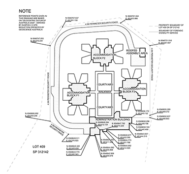
omit, insert—schedule 1, located on lot 409 on SP312142
9Replacement of schedule (Forensic Disability Service)
Schedule—
omit, insert—section 4
Part 5 Amendment of Mineral and Energy Resources (Common Provisions) Regulation 2016
This part amends the Mineral and Energy Resources (Common Provisions) Regulation 2016.
11Amendment of s 62 (Surat Basin Transitional Area—Act, s 242)
Section 62—
insert—(2)In this section, position is defined by reference to GDA94.(3)In this section—GDA94 means the Geocentric Datum of Australia, commonly called ‘GDA94’, notified in the Commonwealth of Australia Gazette No. GN 35 on 6 September 1995, at page 3369.
Part 6 Amendment of Mineral Resources Regulation 2013
This part amends the Mineral Resources Regulation 2013.
13Amendment of s 16 (Partial relinquishment reports and partial surrender reports—Act, ss 178B and 231AB)
Section 16(5), definition general area information, paragraph (b), from ‘location’ to ‘1994’—
omit, insert—position, identified by reference to the geodetic reference framework prescribed for the Survey and Mapping Infrastructure Act 2003, section 6(4)
Part 7 Amendment of Nature Conservation (Protected Areas Management) Regulation 2017
This part amends the Nature Conservation (Protected Areas Management) Regulation 2017.
15Replacement of s 13 (References to latitudes and longitudes)
Section 13—
omit, insert—13Measurement of position under regulation
(1)In this regulation, position is defined by reference to GDA2020.(2)In this section—GDA2020 means the Reference Frame under the National Measurement (Recognized-Value Standard of Measurement of Position) Determination 2017 (Cwlth) as in force on 1 July 2020.
16Amendment of sch 3 (Permitted uses in national parks)
Schedule 3, part 1, table, entry for Goold Island National Park, column 2, ‘latitude 18°9.645' south, longitude 146°9.991' east’—
omit, insert—latitude 18°9.644' south, longitude 146°9.992' east
17Amendment of sch 6 (Prescribed national parks within which fish, invertebrate animals and mud crabs may be taken)
Schedule 6, table, entry for Conway National Park, column 2, paragraph (b)(ii), editor’s note, ‘latitude 20°25.407' south’—
omit, insert—latitude 20°25.406' south
Part 8 Amendment of Queensland Heritage Regulation 2015
This part amends the Queensland Heritage Regulation 2015.
After section 2—
insert—2AMeasurement of position under regulation
(1)In this regulation, position is defined by reference to GDA2020.(2)In this section—GDA2020 means the Reference Frame under the National Measurement (Recognized-Value Standard of Measurement of Position) Determination 2017 (Cwlth) as in force on 1 July 2020.
20Replacement of sch 1 (Protected area)
Schedule 1—
omit, insert—section 5
The part of lot 17 on SP263954 within the following boundary—•from latitude 25º11'21.913'' south, longitude 139º48'4.573'' east•along the boundary of lot 17 on SP263954 to latitude 25º06'22.444'' south, longitude 139º48'28.895'' east•along the boundary of lot 17 on SP263954 to latitude 25º07'0.357'' south, longitude 139º55'50.381'' east•along an imaginary line between latitude 25º07'0.357'' south, longitude 139º55'50.381'' east and latitude 25º11'56.405'' south, longitude 139º55'22.388'' east•along an imaginary line between latitude 25º11'56.405'' south, longitude 139º55'22.388'' east and latitude 25º11'21.913'' south, longitude 139º48'4.573'' eastA map showing the approximate location of the protected area is available for inspection at the department’s head office and on the department’s website.
Part 9 Amendment of Recreation Areas Management Regulation 2017
This part amends the Recreation Areas Management Regulation 2017.
22Amendment of s 10 (Exemptions for use of motor vehicles—recreation areas—Act, s 109)
(1)Section 10(1)(b)(iv), ‘longitude 153º04'29''’—
omit, insert—longitude 153º04'29'' east
(2)Section 10(1)(c)(i), ‘longitude 153º46'59'' east’—
omit, insert—longitude 153º26'59'' east
(3)Section 10—
insert—(1A)In this section, position is defined by reference to GDA2020.(4)Section 10(2)—
insert—GDA2020 means the Reference Frame under the National Measurement (Recognized-Value Standard of Measurement of Position) Determination 2017 (Cwlth) as in force on 1 July 2020.(5)Section 10(1A) and (2)—
renumber as section 10(2) and (3).
Part 10 Amendment of Traffic Regulation 1962
This part amends the Traffic Regulation 1962.
24Amendment of s 211 (Markings or writings on particular photographic detection device images)
(1)Section 211—
insert—(1A)In schedule 16, position is measured by reference to GDA2020.(2)Section 211(2)—
insert—GDA2020 means the Reference Frame under the National Measurement (Recognized-Value Standard of Measurement of Position) Determination 2017 (Cwlth) as in force on 1 July 2020.(3)Section 211(1A) and (2)—
renumber as section 211(2) and (3).
25Amendment of sch 16 (Data blocks for ANPR camera systems used to provide evidence of registration offences or CTP insurance offences)
Schedule 16, ‘using the coordinate framework known as the Geocentric Datum of Australia (GDA94)’—
omit.
Part 11 Amendment of Transport Infrastructure (Ports) Regulation 2016
This part amends the Transport Infrastructure (Ports) Regulation 2016.
After section 3—
insert—(1)In this regulation, position is defined by reference to GDA2020.(2)In this section—GDA2020 means the Reference Frame under the National Measurement (Recognized-Value Standard of Measurement of Position) Determination 2017 (Cwlth) as in force on 1 July 2020.
28Amendment of s 6 (Limits of other particular ports)
Section 6(4), ‘Kurumba’—
omit, insert—Karumba
29Amendment of sch 2 (Port limits—areas for section 5(1) or 6)
(1)Schedule 2, section 1—
omit, insert—For section 5(1), the area is the area within the following—•from the high water mark at the northern extremity of Point Cartwright at approximate latitude 26° 40.764' south, longitude 153° 08.341' east•then generally north-easterly to latitude 26° 38.326' south, longitude 153° 15.830' east•then south to latitude 26° 48.999' south, longitude 153° 15.830' east•then generally south-westerly to latitude 26° 50.382' south, longitude 153° 11.261' east•then generally south-easterly to latitude 27° 07.220' south, longitude 153° 21.670' east•then generally southerly to latitude 27° 14.556' south, longitude 153° 21.160' east•then generally south-easterly to latitude 27° 15.546' south, longitude 153° 22.642' east•then generally south-south-westerly to latitude 27° 20.485' south, longitude 153° 20.816' east•then generally west-south-westerly to the mangroves on the eastern side of Fisherman Islands at latitude 27° 22.825' south, longitude 153° 10.977' east•then generally south-westerly passing through mangrove islands to the east of Fisherman Islands to latitude 27° 23.979' south, longitude 153° 10.171' east•then generally easterly to latitude 27° 23.913' south, longitude 153° 10.568' east•then generally south-easterly to latitude 27° 25.011' south, longitude 153° 11.442' east•then generally southerly to latitude 27° 25.171' south, longitude 153° 11.488' east•then generally west-south-westerly to the high-water mark at approximate latitude 27° 25.542' south, longitude 153° 10.069' east on the mainland near Lytton•then generally northerly and then westerly along the high-water mark of the southern bank of the Brisbane River to the north-western extremity of Bulimba Point at approximate latitude 27° 26.614' south, longitude 153° 03.064' east•then generally north-westerly across the Brisbane River to the high-water mark of the Brisbane River at the eastern extremity of Newstead Park at approximate latitude 27° 26.538' south, longitude 153° 02.855' east•then generally easterly along the high-water mark of the northern bank of the Brisbane River to approximate latitude 27° 23.674' south, longitude 153° 08.848' east on the south bank of Boggy Creek•then generally north-westerly across Boggy Creek to the high-water mark on the north bank of Boggy Creek at approximate latitude 27° 23.496' south, longitude 153° 08.571' east•then generally north-easterly along the high-water mark to approximate latitude 27° 22.680' south, longitude 153° 09.611' east at the eastern extremity of Luggage Point•then generally north-easterly to latitude 27° 22.483' south, longitude 153° 09.765' east•then generally northerly to latitude 27° 11.658' south, longitude 153° 10.808' east•then generally east-north-easterly to latitude 27° 09.689' south, longitude 153° 18.706' east•then generally north-north-westerly to latitude 26° 51.832' south, longitude 153° 08.631' east•then generally northerly to latitude 26° 49.484' south, longitude 153° 08.227' east•then generally north-easterly to latitude 26° 48.231' south, longitude 153° 09.849' east off Caloundra Head•then generally northerly to latitude 26° 44.956' south, longitude 153° 09.844' east•then generally westerly to the high-water mark on the mainland at approximate latitude 26° 44.815' south, longitude 153° 08.173' east•then generally northerly along the high-water mark on the mainland to the northern extremity of Point Cartwright at approximate latitude 26° 40.764' south, longitude 153° 08.341' east.(2)Schedule 2, section 5—
omit, insert—For section 6(1) and (2), the area described for the Port of Cape Flattery is the area within the following—•from the high-water mark at the north-eastern extremity of Point Lookout•to latitude 14° 49.909' south, longitude 145° 15.319' east•to latitude 14° 55.109' south, longitude 145° 22.158' east•to latitude 14° 59.909' south, longitude 145° 22.962' east•due west to the high-water mark on the mainland at approximate latitude 14° 59.909' south•along the high-water mark, initially in a northerly direction, to the north-eastern extremity of Point Lookout.(3)Schedule 2, section 12—
omit, insert—For section 6(1) and (2), the area described for the Port of Mourilyan is the area within the following—•from the intersection of the high-water mark and latitude 17° 39.008' south in the vicinity of the eastern side of Double Point•to latitude 17° 39.008' south, longitude 146° 11.565' east•to latitude 17° 34.908' south, longitude 146° 10.264' east•to the high-water mark on the mainland at latitude 17° 34.908' south•along the high-water mark, in a southerly direction, to latitude 17° 39.008' south in the vicinity of the eastern side of Double Point.(4)Schedule 2, section 18, ‘Kurumba’—
omit, insert—Karumba
30Amendment of sch 3 (Dictionary)
Schedule 3, definitions latitude and longitude—
omit.
Part 12 Amendment of Transport Infrastructure (Waterways Management) Regulation 2012
This part amends the Transport Infrastructure (Waterways Management) Regulation 2012.
32Replacement of s 3 (References to latitude or longitude)
Section 3—
omit, insert—(1)In this regulation, position is defined by reference to GDA2020.(2)In this section—GDA2020 means the Reference Frame under the National Measurement (Recognized-Value Standard of Measurement of Position) Determination 2017 (Cwlth) as in force on 1 July 2020.
Part 13 Amendment of Transport Operations (Marine Pollution) Regulation 2018
This part amends the Transport Operations (Marine Pollution) Regulation 2018.
34Amendment of sch 6 (Designated areas within the Great Barrier Reef Coast Marine Park)
(1)Schedule 6, section 2—
omit, insert—(1)In this schedule, position is defined by reference to GDA2020.(2)In this section—GDA2020 means the Reference Frame under the National Measurement (Recognized-Value Standard of Measurement of Position) Determination 2017 (Cwlth) as in force on 1 July 2020.(2)Schedule 6, section 5—
omit, insert—The area within the following boundary—•from where latitude 24º00.527' south intersects the mainland at low waterLatitude 24º00.527' south intersects the mainland at low water near Spit End.•then south-westerly along the geodesic that passes through the following points to where the geodesic intersects the coastal 500m line around the mainland at Rodds Peninsula—•where the mainland at low water intersects latitude 24º00.527' south•where latitude 24º01.817' south intersects Hummock Hill Island at low water•then generally northerly, north-easterly, easterly and south-easterly along the coastal 500m line around the mainland at Rodds Peninsula to where it intersects longitude 151º43.063' east•then south along longitude 151º43.063' east to where it intersects the mainland at high waterLongitude 151º43.063' east intersects the mainland at high water on Rodds Peninsula.•then generally north-westerly, westerly and southerly along the mainland at high water to where it intersects latitude 24º00.527' southLatitude 24º00.527' south intersects the mainland at high water near Spit End.•then west along latitude 24º00.527' south to where it intersects the mainland at low water.(3)Schedule 6, section 6(a) and (b)—
omit, insert—(a)the area within the following boundary—•from the most western point where North Keppel Island at HAT intersects latitude 23º04.661' south•then west along latitude 23º04.661' south to where it intersects the coastal 500m line around North Keppel Island•then generally south-easterly along the coastal 500m line around North Keppel Island to where it intersects latitude 23º04.991' south•then east along latitude 23º04.991' south to where it intersects North Keppel Island at HAT•then generally north-westerly along North Keppel Island at HAT to the most western point where it intersects latitude 23º04.661' south;(b)the area within the following boundary—•from the most western point where Great Keppel Island at HAT intersects latitude 23º10.697' south•then west along latitude 23º10.697' south to where it intersects the coastal 500m line around Great Keppel Island•then generally southerly along the coastal 500m line around Great Keppel Island to where it intersects latitude 23º11.339' south•then east along latitude 23º11.339' south to where it intersects Great Keppel Island at HAT•then generally northerly along Great Keppel Island at HAT to the most western point where it intersects latitude 23º10.697' south;(4)Schedule 6, section 6(e), ‘along a geodesic’—
omit, insert—along the geodesic
(5)Schedule 6, section 7, ‘along a geodesic’—
omit, insert—along the geodesic
(6)Schedule 6, section 7(a), first dot point, note, ‘latitude 21º51.174' south’—
omit, insert—latitude 21º51.173' south
(7)Schedule 6, section 8(b)—
omit, insert—(b)the area within the following boundary—•from where latitude 20º46.823' south intersects the western side of Carlisle Island at low water•then east along latitude 20º46.823' south to the most western point where it intersects Carlisle Island at HAT•then generally easterly along Carlisle Island at HAT to where it intersects longitude 149º17.994' east on the southern side of the island•then south along longitude 149º17.994' east to where it intersects the southern side of Carlisle Island at low water•then westerly along the geodesic to where latitude 20º48.149' south intersects the eastern side of Brampton Island at low water•then south along latitude 20º48.149' south to where it intersects the eastern side of Brampton Island at HAT•then generally westerly along Brampton Island at HAT to where it intersects longitude 149º15.672' east•then north along longitude 149º15.672' east to where it intersects the northern side of Brampton Island at low water•then north-easterly along the geodesic to where latitude 20º46.823' south intersects the western side of Carlisle Island at low water;(8)Schedule 6, section 8(c), fifth dot point, ‘along a geodesic’—
omit, insert—along the geodesic
(9)Schedule 6, section 9(c) to (i), ‘along a geodesic’—
omit, insert—along the geodesic
(10)Schedule 6, section 9(i), fourth dot point, ‘latitude 23º53.628' south’—
omit, insert—latitude 23º53.627' south
(11)Schedule 6, section 10(a) and (c), ‘along a geodesic’—
omit, insert—along the geodesic
(12)Schedule 6, section 10(d)—
omit, insert—(d)the area within the following boundary—•from the most eastern point where latitude 20º25.895' south intersects the mainland at low water•then north-easterly along the geodesic to the most southern point of the coastal 100m line around Calf Island•then generally north-easterly, northerly and north-westerly along the coastal 100m line around Calf Island to the most eastern point where it intersects the coastal 100m line around Cow Island•then generally northerly, north-westerly and westerly along the coastal 100m line around Cow Island to where it intersects the mainland at low water•then generally southerly along the mainland at low water to the most eastern point where it intersects latitude 20º25.895' south;(13)Schedule 6, section 10(e), second dot point, note, ‘latitude 20º01.344' south’—
omit, insert—latitude 20º01.343' south
(14)Schedule 6, section 11—
omit, insert—11Part of Bowling Green Bay Segment
The area within the following boundary—•from where the mainland at high water intersects latitude 19º15.299' south near Cape Woora•then east along latitude 19º15.299' south to where it intersects the coastal 500m line around the mainland•then generally south-easterly and westerly along the coastal 500m line around the mainland to where it intersects latitude 19º16.901' south•then west along latitude 19º16.901' south to where it intersects the mainland at high water•then generally easterly and north-westerly along the mainland at high water to where it intersects latitude 19º15.299' south near Cape Woora.(15)Schedule 6, section 12, ‘along a geodesic’—
omit, insert—along the geodesic
(16)Schedule 6, section 14—
omit, insert—14Part of Palm Islands Segment
The area within the following boundary—•from the most western point where latitude 18º36.899' south intersects Orpheus Island at HAT•then generally northerly, easterly, southerly and south-westerly along Orpheus Island at HAT to its most southern point•then south along the longitude that passes through the most southern point of Orpheus Island at HAT to where the longitude intersects the coastal 500m line around Orpheus Island•then generally north-easterly, northerly, westerly and southerly along the coastal 500m line around Orpheus Island to the most western point where it intersects latitude 18º36.899' south•then east along latitude 18º36.899' south to the most western point where it intersects Orpheus Island at HAT.(17)Schedule 6, section 15(d)—
omit, insert—(d)the part of Mourilyan Creek that is between the following—•latitude 17º38.801' south•latitude 17º40.907' south;(18)Schedule 6, section 16(1)(b)—
omit, insert—(b)the area that is known as Ellie Point sand reserve and has the following boundary—•from latitude 16º51.908' south, longitude 145º46.065' eastLatitude 16º51.908' south, longitude 145º46.065' east is on the right bank of the Barron River.•then easterly along the geodesic to the most northern point of False Cape at LATThe most northern point of False Cape at LAT is on the western side of Trinity Inlet.•then south along the mainland at LAT to where it intersects the latitude that passes through the most eastern point of Ellie Point•then west along the latitude that passes through the most eastern point of Ellie Point to the most eastern point of Ellie Point•then north-westerly to the south-eastern corner of lot 51 on plan NR3159•then north-westerly along the eastern boundary of lot 51 on plan NR3159 to latitude 16º51.908' south, longitude 145º46.065' east;(19)Schedule 6, section 18(b), ‘along a geodesic’—
omit, insert—along the geodesic
(20)Schedule 6, section 19(b) to (d)—
omit, insert—(b)the area within the following boundary—•from where latitude 15º45.869' south intersects the mainland at HATLatitude 15º45.869' south intersects the mainland at HAT near Obree Point.•then generally southerly, easterly, south-easterly and southerly along the mainland at HAT to where it intersects latitude 15º50.861' southThe mainland at HAT intersects latitude 15º50.861' south near the northern bank of Fritz Creek.•then east along latitude 15º50.861' south to where it intersects the coastal 500m line around the mainland•then generally northerly, north-westerly, westerly and northerly along the coastal 500m line around the mainland to where it intersects latitude 15º45.869' south•then west along latitude 15º45.869' south to where it intersects the mainland at HAT;(c)the area within the following boundary—•from where latitude 16º04.901' south intersects the mainland at HATLatitude 16º04.901' south intersects the mainland at HAT just south of Cape Tribulation.•then generally northerly and north-westerly along the mainland at HAT to where it intersects longitude 145º22.788' east•then north along longitude 145º22.788' east to where it intersects the coastal 500m line around the mainland•then generally southerly along the coastal 500m line around the mainland to the most eastern point where it intersects latitude 16º04.901' south•then west along latitude 16º04.901' south to where it intersects the mainland at HAT;(d)the part of the Daintree River that is south of latitude 16º17.495' south.(21)Schedule 6, section 20(b)—
omit, insert—(b)the area within the following boundary—•from the most western point of the 500m line around Pethebridge Islets Reef (reef 14-122b)•then north-westerly along the geodesic that passes through the following points—•the most western point of the 500m line around Pethebridge Islets Reef (reef 14-122b)•the most eastern point of Marched Point at low waterto where the geodesic intersects the geodesic that passes through the following points—
•latitude 14º18.178' south, longitude 145º39.064' east•latitude 14º39.905' south, longitude 144º56.565' east•then south-westerly along the geodesic that passes through the following points to where the geodesic intersects the mainland at low water—•latitude 14º18.178' south, longitude 145º39.064' east•latitude 14º39.905' south, longitude 144º56.565' east•then generally south-easterly along the mainland at low water to where it intersects latitude 14º44.195' south•then east along latitude 14º44.195' south to where it intersects the coastal 100m line around the mainland•then generally south-easterly and easterly along the coastal 100m line around the mainland to where it intersects the geodesic that passes through the following points—•the most northern point on Lookout Point at low water•the most western point of the 500m line around Pethebridge Islets Reef (reef 14-112b)•then north-westerly along that geodesic to the most western point of the 500m line around Pethebridge Islets Reef (reef 14-122b);(22)Schedule 6, section 20(c), (e) and (k), ‘along a geodesic’—
omit, insert—along the geodesic
(23)Schedule 6, section 20(c), ‘latitude 14º41.328' south’—
omit, insert—latitude 14º41.327' south
(24)Schedule 6, section 20(d)—
omit, insert—(d)the area within the following boundary—•from the most western point where latitude 14º38.987' south intersects Lizard Island at high water•then generally southerly, south-easterly and south-westerly along Lizard Island at high water to its most western pointThe most western point of Lizard Island is adjacent to Chinamans Ridge.•then north-westerly along the geodesic to the most western point of Lizard Island at low water•then north-westerly along the geodesic that passes through the following points to where the geodesic intersects the seaward edge of Lizard Island Reef (reef 14-116a)—•the most western point of Lizard Island at low water•latitude 14º39.737' south, longitude 145º26.604' east•then generally northerly along the seaward edge of Lizard Island Reef (reef 14-116a) to the most western point where it intersects latitude 14º38.987' south•then east along latitude 14º39.076' south to the most western point where it intersects Lizard Island at high water;
Part 14 Amendment of Transport Operations (Marine Safety) Regulation 2016
This part amends the Transport Operations (Marine Safety) Regulation 2016.
36Replacement of s 5 (References to latitude or longitude)
Section 5—
omit, insert—(1)In this regulation, position is defined by reference to GDA2020.(2)In this section—GDA2020 means the Reference Frame under the National Measurement (Recognized-Value Standard of Measurement of Position) Determination 2017 (Cwlth) as in force on 1 July 2020.
37Amendment of sch 2 (Pilotage areas)
(1)Schedule 2, section 1(a)—
omit, insert—(a)waters bounded by an imaginary line drawn—•starting at the high-water mark at the point where latitude 27° 39.899' south intersects with the eastern shoreline of the mainland•then east to the high-water mark on the western shoreline of North Stradbroke Island at latitude 27º 39.899' south•then by the high-water mark in a southerly direction along the western shoreline and in an easterly direction along the southern shoreline of North Stradbroke Island to the south-eastern tip of the island at approximate latitude 27º 43.639' south, longitude 153º 27.100' east•then to the high-water mark on the northern tip of South Stradbroke Island at approximate latitude 27º 45.289' south, longitude 153º 26.690' east•then in a southerly direction along the western shoreline and in an easterly direction along the southern shoreline of South Stradbroke Island to the seaward tip of the northern breakwater at the entrance to the Gold Coast Seaway•then in an easterly direction to latitude 27° 55.899' south, longitude 153° 27.060' east•then south to latitude 27° 56.099' south, longitude 153° 27.060' east•then in a westerly direction to the seaward tip of the southern breakwater at the entrance to the Gold Coast Seaway•then by the high-water mark in a westerly direction along the northern shoreline, in a southerly direction along the western shoreline of The Spit and in a northerly direction along the eastern shoreline of the mainland to the starting point; and(2)Schedule 2, section 2(a)—
omit, insert—(a)waters bounded by an imaginary line drawn—•starting at the high-water mark at the north head of the Maroochy River entrance•then east to longitude 153° 10.060' east•then in a south-south-easterly direction to latitude 26° 49.899' south, longitude 153° 15.060' east•then in a south-easterly direction to the high-water mark on the north-eastern tip of Cape Moreton on Moreton Island•then by the high-water mark in a westerly direction along the northern shoreline and in a southerly direction along the western shoreline of Moreton Island to the southern tip of the island•then to the high-water mark on the northern tip of North Stradbroke Island•then by the high-water mark in a southerly direction along the western shoreline of North Stradbroke Island to latitude 27° 39.899' south•then west to the high-water mark on the mainland at latitude 27º 39.899' south•then by the high-water mark in a northerly direction along the eastern shoreline of the mainland to the starting point; and(3)Schedule 2, section 4(a)—
omit, insert—(a)waters bounded by an imaginary line drawn—•starting at the high-water mark at the point where latitude 25° 06.899' south intersects with the eastern shoreline of the mainland•then generally north-easterly along the geodesic to latitude 24° 44.899' south, longitude 152° 45.060' east•then east along latitude 24° 44.899' south to its intersection with the high-water mark on the western shoreline of Fraser Island•then generally southerly along the high-water mark on the western shoreline of Fraser Island, and then generally northerly along the high-water mark on the eastern shoreline of Fraser Island to the intersection of that high-water mark with latitude 25° 46.309' south•then along latitude 25° 46.309' south to its intersection with longitude 153°05.000' east•then south along longitude 153° 05.000' east to its intersection with the high-water mark on the mainland•then generally northerly along the high-water mark on the mainland to the starting point; and(4)Schedule 2, section 6(a)—
omit, insert—(a)waters bounded by an imaginary line drawn—•starting at the high-water mark at Connor Bluff on Curtis Island at approximate latitude 23° 42.909' south, longitude 151° 17.660' east•then in a south-easterly direction to latitude 23° 49.509' south, longitude 151° 34.660' east•then south to latitude 23° 56.509' south, longitude 151° 34.660' east•then in a south-westerly direction to the high-water mark at the northern tip of Tiber Point on Hummock Hill Island•then west to the high-water mark on Wild Cattle Island•then by the high-water mark in a northerly direction along the eastern shoreline of Wild Cattle Island to the northern tip of the island•then west to the high-water mark on the eastern shoreline of the mainland•then by the high-water mark in a northerly direction along the eastern shoreline of the mainland to latitude 23° 38.409' south•then east to the high-water mark of the western shoreline of Curtis Island at latitude 23º 38.409' south•then by the high-water mark in a southerly direction along the western shoreline, in an easterly direction along the southern shoreline and in a northerly direction along the eastern shoreline of Curtis Island to the starting point; and(5)Schedule 2, section 7(a), ‘latitude 23° 38.41' south’—
omit, insert—latitude 23° 38.409' south
(6)Schedule 2, section 8(a)—
omit, insert—(a)waters bounded by an imaginary line drawn—•starting at the high-water mark at the southern extremity of the north head of Bakers Creek entrance•then generally north-easterly along the geodesic to latitude 21° 10.759' south, longitude 149° 17.730' east•then generally north-easterly along the geodesic to latitude 21° 09.909' south, longitude 149° 20.060' east•then east to latitude 21° 09.909' south, longitude 149° 30.060' east•then south to latitude 21° 17.909' south, longitude 149° 30.060' east•then west to the intersection of the high-water mark on the mainland with latitude 21° 17.909' south•then generally northerly along the high-water mark on the mainland to the starting point; and(7)Schedule 2, section 9(a)—
omit, insert—(a)waters bounded by an imaginary line drawn—•starting at the high-water mark at the northern extremity of Slade Point•then generally easterly along the geodesic to latitude 21° 03.809' south, longitude 149° 22.060' east•then south to latitude 21° 09.909' south, longitude 149° 22.060' east•then west to latitude 21° 09.909' south, longitude 149° 20.060' east•then generally south-westerly along the geodesic to latitude 21° 10.759' south, longitude 149° 17.730' east•then generally south-westerly along the geodesic to the intersection with the high-water mark at the southern extremity of the north head of Bakers Creek entrance•then generally northerly along the high-water mark on the mainland to the starting point; and(8)Schedule 2, section 10(a), second dot point, ‘latitude 20º 01.19' south, longitude 148º 52.84' east’—
omit, insert—latitude 20º 01.189' south, longitude 148º 52.840' east
(9)Schedule 2, section 10(a), third dot point, ‘latitude 20º 02.94' south, longitude 148º 58.63' east’—
omit, insert—latitude 20º 02.939' south, longitude 148º 58.630' east
(10)Schedule 2, section 11(a), second dot point, ‘(latitude 20° 01.34' south, longitude 148° 15.39' east)’—
omit, insert—(latitude 20° 01.339' south, longitude 148°15.390' east)
(11)Schedule 2, section 11(a), third dot point, ‘(latitude 20° 01.05' south, longitude 148° 14.91' east)’—
omit, insert—(latitude 20° 01.049' south, longitude 148° 14.910' east)
(12)Schedule 2, section 12(a)—
omit, insert—(a)waters bounded by an imaginary line drawn—•starting at the high-water mark on the eastern shoreline of the mainland at longitude 147° 59.070' east•then north to latitude 19° 47.909' south, longitude 147° 59.070' east•then east to latitude 19° 47.909' south, longitude 148° 08.070' east•then in a south-easterly direction to the high-water mark at the northern tip of Gloucester Head on Gloucester Island•then in a southerly direction by the high-water mark along the western shoreline of Gloucester Island to the southern tip of the island•then to the high-water mark on the northern tip of Cape Gloucester on the mainland•then by the high-water mark along the shoreline of the mainland to the intersection of the high-water mark and the northern edge of the wharf at Bowen (latitude 20° 01.049' south, longitude 148° 14.910' east)•then 123° (T) by a straight line to the port entrance beacon to Bowen Boat Harbour (latitude 20° 01.339' south, longitude 148° 15.390' east)•then 106° (T) by a straight line to the high-water mark at the southern tip of Dalrymple Point•then along the shoreline of the mainland at the high-water mark to the starting point; and(13)Schedule 2, section 13(a)—
omit, insert—(a)waters bounded by an imaginary line drawn—•starting at the high-water mark on the northern tip of Cape Cleveland•then in a north-westerly direction to latitude 19° 04.909' south, longitude 146° 52.070' east•then west to latitude 19° 04.909' south, longitude 146° 45.070' east•then south to the high-water mark on the mainland at longitude 146° 45.070' east•then by the high-water mark along the shoreline of the mainland to the starting point; and(14)Schedule 2, section 14(a)—
omit, insert—(a)waters bounded by an imaginary line drawn—•starting at the high-water mark at George Point on Hinchinbrook Island at approximate latitude 18º 29.109' south, longitude 146º 19.500' east•then east to latitude 18° 29.109' south, longitude 146° 26.070' east•then south to latitude 18° 34.909' south, longitude 146° 26.070' east•then west to the high-water mark on the mainland at latitude 18° 34.909' south•then by the high-water mark in a northerly direction along the eastern shoreline of the mainland to approximate latitude 18° 31.409' south, longitude 146° 19.870' east•then 352° (T) by a straight line to the starting point; and(15)Schedule 2, section 16(a), second dot point, ‘latitude 16° 49.875' south’—
omit, insert—latitude 16° 49.874' south
(16)Schedule 2, section 20(a)—
omit, insert—(a)waters bounded by an imaginary line drawn—•starting at the high-water mark on the north-eastern extremity of Point Lookout•then in an easterly direction to latitude 14° 49.909' south, longitude 145° 15.319' east•then in a south-easterly direction to latitude 14° 55.109' south, longitude 145° 22.158' east•then in a southerly direction to latitude 14° 59.909' south, longitude 145° 22.962' east•then west to the high-water mark on the mainland at latitude 14° 59.909' south•then by the high-water mark in a northerly direction along the shoreline of the mainland to the starting point; and(17)Schedule 2, section 22(a)—
omit, insert—(a)waters bounded by an imaginary line drawn—•starting at the high-water mark at approximate latitude 11º 46.999' south, longitude 141º 58.540' east on the mainland, south of the entrance of the Skardon River•then west to latitude 11º 46.999' south, longitude 141º 57.000' east•then north to latitude 11º 44.499' south, longitude 141º 57.000' east•then east to the high-water mark on the mainland at approximate latitude 11º 44.499' south, longitude 142º 00.120' east•then by the high-water mark, initially in a southerly direction, to the starting point; and(18)Schedule 2, section 23A(a)—
omit, insert—(a)waters bounded by an imaginary line drawn—•starting at the high-water mark on the shoreline of the mainland at approximate latitude 12º 54.599' south, longitude 141º 38.180' east•then in a generally northerly direction along the south-west boundary of the Weipa pilotage area to latitude 12° 49.999' south, longitude 141° 37.600' east•then west to latitude 12° 49.999' south, longitude 141° 32.480' east•then in a generally southerly direction to latitude 12° 59.999' south, longitude 141° 32.730' east•then east to the high-water mark on the shoreline of the mainland at approximate latitude 12° 59.999' south, longitude 141° 35.160' east•then by the high-water mark in a generally north-easterly direction along the shoreline of the mainland to the starting point; and
38Amendment of sch 3 (Compulsory pilotage areas)
(1)Schedule 3, section 6(a)—
omit, insert—(a)waters bounded by an imaginary line drawn—•starting at the high-water mark at the southern extremity of the north head of Bakers Creek entrance•then generally north-easterly along the geodesic to latitude 21° 10.759' south, longitude 149° 17.730' east•then generally south-easterly along the geodesic to latitude 21° 13.999' south, longitude 149° 20.500' east•then south to latitude 21°15.689' south, longitude 149° 20.500' east•then generally north-easterly along the geodesic to latitude 21° 14.489' south, longitude 149° 25.410' east•then generally south-easterly along the geodesic to latitude 21° 14.799' south, longitude 149° 25.500' east•then generally south-westerly along the geodesic to latitude 21° 16.109' south, longitude 149° 20.500' east•then south to latitude 21° 17.909' south, longitude 149° 20.500' east•then west to the intersection of the high-water mark on the mainland with latitude 21° 17.909' south•then generally northerly along the high-water mark on the mainland to the starting point; and(2)Schedule 3, section 7(a)—
omit, insert—(a)waters bounded by an imaginary line drawn—•starting at the high-water mark at the northern extremity of Slade Point•then generally easterly along the geodesic to latitude 21° 03.809' south, longitude 149° 16.000' east•then south to latitude 21° 06.999' south, longitude 149° 16.000' east•then generally south-easterly along the geodesic to latitude 21° 10.759' south, longitude 149° 17.730' east•then generally south-westerly along the geodesic to the intersection with the high-water mark at the southern extremity of the north head of Bakers Creek entrance•then generally northerly along the high-water mark on the mainland to the starting point; and(3)Schedule 3, section 12(a)—
omit, insert—(a)waters bounded by an imaginary line drawn—•starting at the high-water mark on the north-western extremity of Cape Grafton•then in a northerly direction to latitude 16° 49.999' south, longitude 145° 54.954' east•then west to latitude 16° 49.999' south, longitude 145° 51.000' east•then north to latitude 16° 48.873' south, longitude 145° 51.000' east•then in a west-north-westerly direction to the high-water mark on the northern extremity of Taylor Point•then by the high-water mark in a southerly direction along the shoreline of the mainland to the starting point; and(4)Schedule 3, section 15(a)—
omit, insert—(a)waters bounded by an imaginary line drawn—•starting at the high-water mark at approximate latitude 11º 46.729' south, longitude 141º 58.630' east on the mainland, south of the entrance of the Skardon River•then west to latitude 11º 46.729' south, longitude 141º 57.280' east•then north to latitude 11º 44.769' south, longitude 141º 57.280' east•then east to the high-water mark on the mainland at latitude 11º 44.769' south, longitude 142º 00.120' east•then by the high-water mark, initially in a southerly direction, to the starting point; and
39Amendment of sch 5 (Marine zones)
(1)Schedule 5, part 2, section 2(2)(a) and (b)—
omit, insert—(a)the area of the Noosa River at Tewantin within the following boundary—•starting at latitude 26° 23.266' south, longitude 153° 02.667' east on the eastern shore of the Noosa River•then generally northerly along the eastern shore of the Noosa River to latitude 26° 22.724' south, longitude 153° 02.812' east•then generally south-westerly along the geodesic to latitude 26° 22.770' south, longitude 153° 02.737' east on the eastern shore of Makepeace Island•then generally southerly along the eastern shore of Makepeace Island to latitude 26° 22.951' south, longitude 153° 02.785' east•then generally south-westerly along the geodesic to latitude 26° 22.993' south, longitude 153° 02.738' east on the eastern shore of Sheep Island•then generally south-westerly along the eastern shore of Sheep Island to latitude 26° 23.193' south, longitude 153° 02.564' east•then generally south-easterly along the geodesic to the starting point; and(b)the area of the Noosa River at Tewantin within the following boundary—•starting at latitude 26° 22.259' south, longitude 153° 02.359' east on the eastern shore of the Noosa River•then generally northerly along the eastern shore of the Noosa River to latitude 26° 21.594' south, longitude 153° 02.414' east•then generally westerly along the geodesic to the western shore of the Noosa River to latitude 26° 21.603' south, longitude 153° 02.331' east•then generally southerly along the western shore of the Noosa River to latitude 26° 22.327' south, longitude 153° 02.264' east•then generally north-easterly along the geodesic to the starting point.(2)Schedule 5, part 2, section 3(4)(a) and (b)—
omit, insert—(a)the waters of the Noosa River downstream of the geodesic between latitude 26° 23.835' south, longitude 153° 03.271' east and latitude 26° 23.584' south, longitude 153° 03.273' east ending at the geodesic between latitude 26° 22.846' south, longitude 153° 04.856' east and latitude 26° 22.770' south, longitude 153° 04.586' east;(b)the waters of Weyba Creek downstream of the geodesic between latitude 26° 23.834' south, longitude 153° 04.525' east and latitude 26° 23.913' south, longitude 153° 04.396' east;(3)Schedule 5, part 2, section 3(5)(a) and (b)—
omit, insert—(a)latitude 26° 23.945' south, longitude 153° 04.655' east;(b)latitude 26° 23.954' south, longitude 153° 04.591' east.
40Amendment of sch 7 (Partially smooth waters)
(1)Schedule 7, section 1, first dot point, ‘latitude 27° 05.90' south’—
omit, insert—latitude 27° 05.899' south
(2)Schedule 7, section 2, fourth to sixth dot points—
omit, insert—•along the western shore of Fraser Island to latitude 25° 22.899' south•to latitude 25° 24.899', longitude 152° 58.060' east•due west to the mainland at latitude 25° 24.899' south.(3)Schedule 7, section 3, third to sixth dot points—
omit, insert—•along the southern shore of Facing Island to latitude 23° 51.909' south•due west to South Trees Island at latitude 23° 51.909' south•along the northernmost shore of South Trees Island to latitude 23° 51.909' south at its western shore•due west to the mainland at latitude 23° 51.909' south.(4)Schedule 7, section 5, second and last dot points—
omit, insert—•to latitude 21º 17.999' south, longitude 149º 20.000' east•to the high-water mark on the mainland at latitude 21º 17.999' south.(5)Schedule 7, section 6—
omit, insert—The waters bounded by an imaginary line drawn—•from the high-water mark on the mainland at latitude 21º 17.999' south•to latitude 21º 17.999' south, longitude 149º 30.000' east•to latitude 21º 09.999' south, longitude 149º 30.000' east•to latitude 21º 06.999' south, longitude 149º 18.500' east•to latitude 21º 02.499' south, longitude 149º 15.000' east•to the high-water mark on the mainland at the northern tip of Slade Point.(6)Schedule 7, section 7—
omit, insert—The waters bounded by an imaginary line drawn—•from the high-water mark on the mainland at the northern tip of Slade Point•to latitude 21º 02.499' south, longitude 149º 15.000' east•to latitude 20º 56.999' south, longitude 149º 11.000' east•to latitude 20º 52.899' south, longitude 149º 04.400' east•to the high-water mark on the mainland at the north-eastern tip of Cape Hillsborough.(7)Schedule 7, section 8—
omit, insert—The waters bounded by an imaginary line drawn—•from the high-water mark on the mainland at the north-eastern tip of Cape Hillsborough•to latitude 20º 52.899' south, longitude 149º 04.400' east•to latitude 20º 44.999' south, longitude 148º 53.000' east•to latitude 20º 35.999' south, longitude 148º 55.000' east•to the high-water mark at the eastern tip of the southern bank of the mouth of Hervey Creek on the mainland.(8)Schedule 7, section 10, ‘latitude 19º 40.02' south, longitude 147º 36.44' east’—
omit, insert—latitude 19º 40.019' south, longitude 147º 36.440' east
(9)Schedule 7, section 12, sixth dot point, ‘latitude 18° 39.31' south’—
omit, insert—latitude 18° 39.309' south
(10)Schedule 7, section 12, tenth dot point, ‘latitude 18° 44.91' south’—
omit, insert—latitude 18° 44.909' south
(11)Schedule 7, section 13, last dot point, ‘latitude 18° 14.91' south’—
omit, insert—latitude 18° 14.909' south
(12)Schedule 7, section 16, third dot point, ‘latitude 10° 43.51' south, longitude 142° 15.87' east’—
omit, insert—latitude 10° 43.509' south, longitude 142° 15.870' east
41Amendment of sch 8 (Smooth waters)
(1)Schedule 8, section 1(1), third dot point, ‘longitude 153° 26.56' east’—
omit, insert—longitude 153° 26.560' east
(2)Schedule 8, section 1(2), first dot point, ‘latitude 27° 05.90' south’—
omit, insert—latitude 27° 05.899' south
(3)Schedule 8, section 1(2), last dot point, ‘longitude 153° 07.81' east’—
omit, insert—longitude 153° 07.810' east
(4)Schedule 8, section 2—
omit, insert—The waters bounded by an imaginary line drawn—•from latitude 25° 24.899' south on the mainland•due east to longitude 152° 58.060' east•in a north-easterly direction to the intersection of latitude 25° 22.899' south and Fraser Island•along the western shore of Fraser Island to longitude 153° 04.060' east•to Inskip Point on the mainland.(5)Schedule 8, section 3, first dot point, ‘latitude 24° 10.332' south’—
omit, insert—latitude 24° 10.331' south
(6)Schedule 8, section 3, last dot point, ‘latitude 24° 9.60' south, longitude 151° 52.96' east’—
omit, insert—latitude 24° 09.599' south, longitude 151° 52.960' east
(7)Schedule 8, section 4, first dot point, ‘latitude 23° 51.91' south’—
omit, insert—latitude 23° 51.909' south
(8)Schedule 8, section 4, fifth dot point, ‘latitude 23° 33.91' south’—
omit, insert—latitude 23° 33.909' south
(9)Schedule 8, section 5, third dot point, ‘latitude 23° 33.91' south’—
omit, insert—latitude 23° 33.909' south
(10)Schedule 8, section 7, last dot point, ‘latitude 18° 14.91' south’—
omit, insert—latitude 18° 14.909' south
(11)Schedule 8, section 10, second dot point, ‘latitude 16° 28.41' south’—
omit, insert—latitude 16° 28.409' south
(12)Schedule 8, section 11, first dot point, ‘longitude 145° 15.39' east’—
omit, insert—longitude 145° 15.390' east
(13)Schedule 8, section 11, second dot point—
omit, insert—•to latitude 15° 27.009' south, longitude 145° 15.670' east(14)Schedule 8, section 12, first and last dot points, ‘longitude 142° 15.37' east’—
omit, insert—longitude 142° 15.370' east
(15)Schedule 8, section 12, second and third dot points, ‘latitude 10° 33.01' south’—
omit, insert—latitude 10° 33.009' south
(16)Schedule 8, section 13, second dot point, ‘latitude 12° 35.01' south, longitude 141° 47.67' east’—
omit, insert—latitude 12° 35.009' south, longitude 141°47.670' east
Part 15 Amendment of Vegetation Management Regulation 2012
This part amends the Vegetation Management Regulation 2012.
43Amendment of s 9 (Application for PMAV—Act, s 20C)
(1)Section 9(2)(a), ‘all’—
omit, insert—both
(2)Section 9(2)(a)(ii)—
omit.(3)Section 9(2)(a)(iii)—
renumber as section 9(2)(a)(ii).(4)Section 9(2)(b), from ‘by reference to’ to ‘for the areas’—
omit.(5)Section 9—
insert—(3)In this section, the position of a point, or boundary of an area, is defined by reference to the geodetic reference framework prescribed for the Survey and Mapping Infrastructure Act 2003, section 6(4).
44Amendment of sch 8 (Dictionary)
Schedule 8, definitions GPS and Map Grid of Australia 1994—
omit.