


This plan may be cited as the Water Plan (Condamine and Balonne) 2019.
The purposes of this plan are to—(a)define the availability of water to which this plan applies; and(b)provide a framework for sustainably managing water to which this plan applies; and(c)identify priorities and mechanisms for dealing with the future water requirements in the plan area; and(d)provide a framework for managing water allocations; and(e)provide a framework for reversing, where practicable, the degradation of natural ecosystems caused by the taking of, or interference with, water to which this plan applies.
The dictionary in schedule 14 defines particular words used in this plan.
Surface water is—(a)water in a watercourse or lake; or(b)water in a spring not connected to water to which the Water Plan (Great Artesian Basin and Other Regional Aquifers) 2017applies; or(c)overland flow water, other than water in a spring connected to water to which the Water Plan (Great Artesian Basin and Other Regional Aquifers) 2017applies.
5Water to which plan applies—Act, s 43
For section 43(1)(a) of the Act, this plan applies to the following water in the plan area—(a)surface water;(b)underground water to which the Water Plan (Great Artesian Basin and Other Regional Aquifers) 2017does not apply.
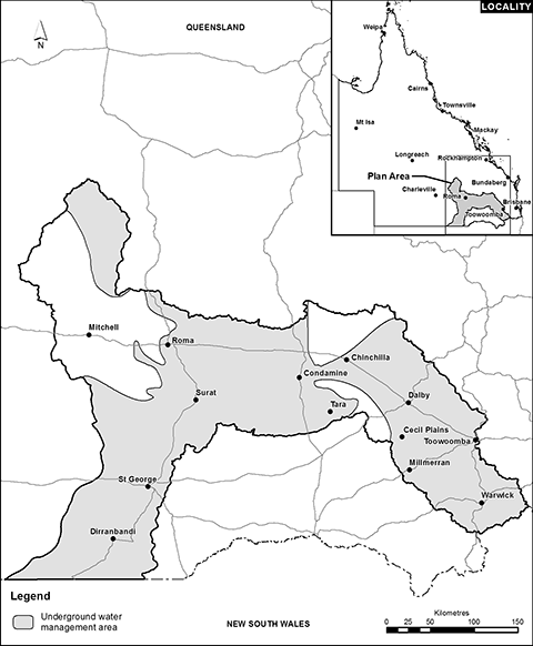
This plan applies to the area shown as the plan area on the map in schedule 1, part 1.
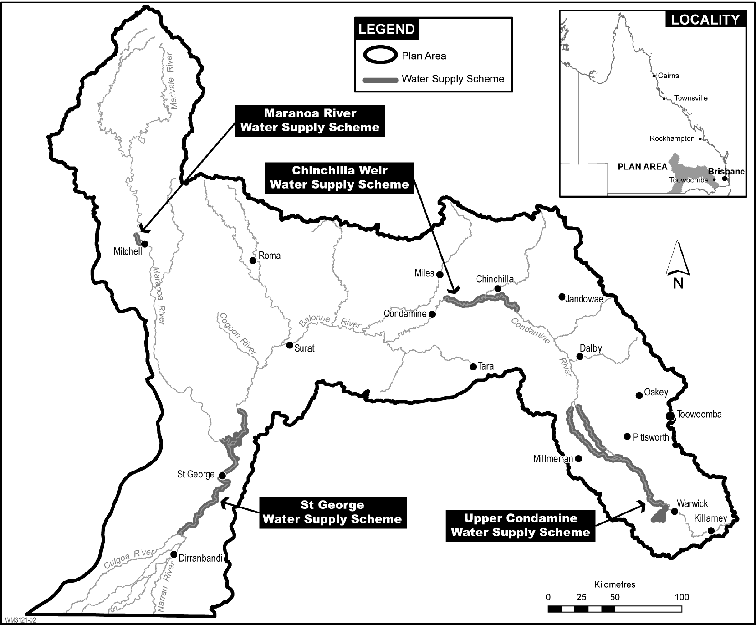
7Water supply schemes and water supply scheme zones
(1)Each part of the plan area shown as a water supply scheme on the map in schedule 2, part 1 is a water supply scheme for this plan.(2)A reference in this plan to a water supply scheme by name is a reference to the water supply scheme given that name on the map in schedule 2, part 1 and in schedule 2, part 2, column 1.(3)Each part of the plan area named and described in schedule 2, part 2, columns 2 and 3, is a water supply scheme zone.
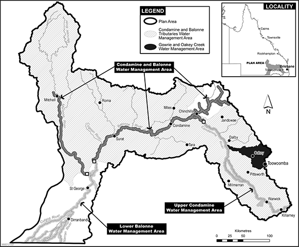
8Water management areas—Act, sch 4
(1)For schedule 4 of the Act, definition water management area, paragraph (b), each part of the plan area shown as a water management area on the map in schedule 3, part 1 is a water management area.(2)A reference in this plan to a water management area by name is a reference to the water management area given that name on a map in schedule 3.
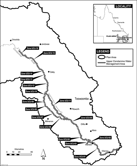
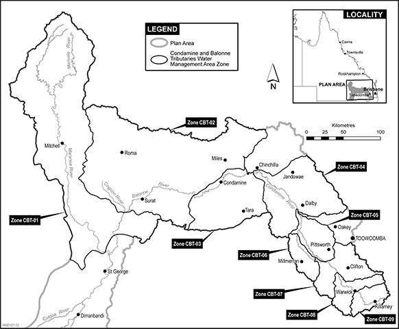
(1)A water management area has 1 or more water management area zones.(2)A water management area zone, for a water management area, is—(a)for the Upper Condamine water management area—(i)shown on the map in schedule 3, part 2; and(ii)named and described in columns 1 and 2 of the table in schedule 3, part 2; and(b)for the Condamine and Balonne water management area—(i)shown on the map in schedule 3, part 3; and(ii)named and described in columns 1 and 2 of the table in schedule 3, part 3; and(c)for the Lower Balonne water management area—(i)shown on the map in schedule 3, part 4; and(ii)named and described in columns 1 and 2 of the table in schedule 3, part 4; and(d)for the Condamine and Balonne Tributaries water management area—shown on the map in schedule 3, part 5; and(e)for the Gowrie and Oakey Creek water management area—(i)shown on the map in schedule 3, part 6; and(ii)named and described in columns 1 and 2 of the table in schedule 3, part 6.(3)A reference in this plan to a water management area zone, in the Condamine and Balonne Tributaries water management area, by name is a reference to the water management area zone given that name on the map in schedule 3, part 5.(4)A reference in this plan to a water management area zone in another water management area by name is a reference to the water management area zone given that name on a map in schedule 3, part 2, 3, 4 or 6 and in column 1 of a table in schedule 3.
10Underground water management area
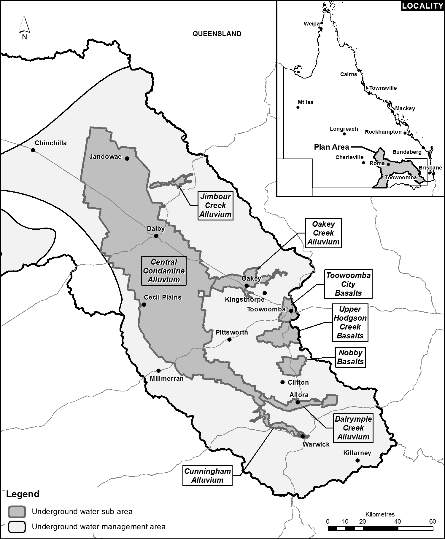
The part of the plan area shown as the underground water management area on the map in schedule 4 is the underground water management area.
(1)Certain parts of the underground water management area are divided into underground water sub-areas.(2)A part of the underground water management area shown on the map in schedule 5 as an underground water sub-area is an underground water sub-area.(3)A reference in this plan to an underground water sub-area by name is a reference to the underground water sub-area given that name in schedule 5.
12Underground water units and underground water sub-units
(1)The underground water management area includes the following aquifers (each an underground water unit)—(a)the St George Alluvium (shallow);(b)the St George Alluvium (deep);(c)the sediments above the Great Artesian Basin;(d)the Upper Condamine Alluvium (Central Condamine Alluvium);(e)the Upper Condamine Alluvium (Tributaries);(f)the Upper Condamine Basalts;(g)the Condamine Fractured Rock;(h)the Queensland Murray-Darling Basin deep.(2)The Upper Condamine Basalts, in the Nobby Basalts underground water sub-area, is made up of the following aquifers (each an underground water sub-unit)—(a)for underground water to which this plan applies above the aquitard in the Upper Condamine Basalts—the Upper Condamine Basalts (Nobby Basalts shallow);(b)for underground water to which this plan applies below the aquitard in the Upper Condamine Basalts—the Upper Condamine Basalts (Nobby Basalts deep).
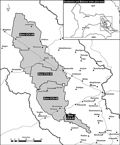
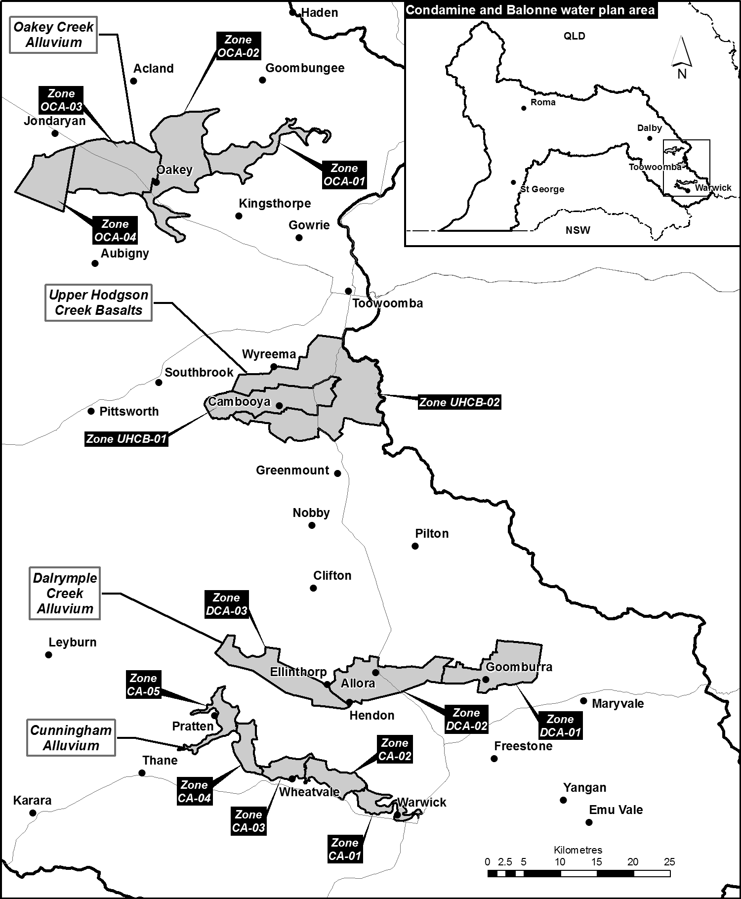
(1)Certain underground water sub-areas are divided into underground water zones.(2)A part of an underground water sub-area, shown on a map in schedule 6 as an underground water zone, is an underground water zone.
For section 43(1)(e)(i) of the Act, the following zones are trading zones for water allocations to which this plan applies—(a)a water supply scheme zone;(b)a water management area zone;(c)an underground water zone.
(1)A node is a point in the plan area.(2)The modelled location of each node is identified, by a letter, on the map in schedule 1, part 1 and is described in schedule 1, part 2.(3)A node may be referred to in this plan by its letter.(4)The actual location of each node is set by—(a)for nodes A to L—the eWater Source computer program; or(b)for nodes M to O—the MODFLOW computer program.
The exact location of the boundaries of each of the following is held in digital electronic form by the department and may be accessed at each office of the department—(a)the plan area;(b)a water supply scheme;(c)a water supply scheme zone;(d)a water management area;(e)a water management area zone;(f)the underground water management area;(g)an underground water sub-area;(h)an underground water zone.The location of each office of the department is available on the department’s website.
This part states, for section 43(1)(b) of the Act, the water plan outcomes for this plan.
A water plan outcome for this plan is that water to which this plan applies is to be allocated and managed in a way that—(a)recognises the natural state of watercourses, lakes, springs and aquifers has changed because of the taking of, or interference with, water; and(b)is consistent with the relevant version of the Basin Plan, including, for example, the sustainable diversion limits; and(c)is consistent with water sharing agreements and commitments between the State and New South Wales; and(d)seeks to achieve a balance between—(i)the economic water plan outcomes stated in section 19; and(ii)the social water plan outcomes stated in section 20; and(iii)the cultural water plan outcomes stated in section 21; and(iv)the environmental water plan outcomes stated in section 22; and(e)promotes improved understanding of—(i)matters affecting the flow-related, and underground water dependent, health of ecosystems, including springs, in the plan area; and(ii)the flow requirements of ecosystems in the plan area; and(iii)the water required for social, spiritual, economic, environmental and cultural uses of water by Aboriginal people; and(iv)the water required to deliver social and economic benefits to communities in the plan area; and(v)the impact of climate change on water availability; and(vi)the actions required to reverse the degradation of natural ecosystems caused by the taking of, or interference with, water to which this plan applies.
19Water plan outcomes—economic
(1)The economic water plan outcomes for this plan are—(a)to maintain the probability of being able to take water to which this plan applies under a water entitlement; and(b)to maintain and, if possible, improve the productive base of underground water to which this plan applies; and(c)to improve and support the effective and efficient operation of the market in water allocations and relocatable water licences; and(d)to maintain the availability of water to which this plan applies for stock purposes and tourism in the plan area; and(e)to maintain the availability of water to which this plan applies for industries dependent on water resources in the plan area; and(f)to maintain and, if possible, improve flood flows to support grazing activities in the plan area and in the Lower Balonne distributary system; and(g)to make water to which this plan applies available to support the economic and social aspirations of Aboriginal people.(2)In this section—relocatable water licence means a water licence that the water management protocol for this plan states may be relocated, in whole or in part, under section 126(1)(a) of the Act.
The social water plan outcomes for this plan are—(a)to maintain—(i)the availability of water to which this plan applies for the supply of urban water to towns and communities dependent on the water resources of the plan area; and(ii)the flows of water to which this plan applies that support water-related aesthetic, cultural and recreational values; and(b)to provide water to which this plan applies for domestic purposes in the plan area.
21Water plan outcomes—cultural
The cultural water plan outcomes for this plan are to maintain flows of water to which this plan applies that support the water-related cultural, spiritual, social and environmental values of Aboriginal people.
22Water plan outcomes—environmental
(1)The environmental water plan outcomes for this plan are—(a)to maintain the probability of being able to take surface water to which this plan applies under a water entitlement held only for providing benefit to the environment; andExamples of a water entitlement held only for providing benefit to the environment—
•a water entitlement held by CEWH•a water entitlement held only for protecting and restoring the health of Murray-Darling Basin ecosystems(b)to maintain and, if possible, improve flows of water to which this plan applies that support—(i)waterholes as refugia; and(ii)river channels; and(iii)river-forming processes; and(c)to maintain and, if possible, improve flows of water to which this plan applies that support bird breeding at Narran Lakes; and(d)to maintain and, if possible, improve flows of water to which this plan applies that support floodplain ecosystems within and downstream of the plan area, including—(i)the Balonne River floodplain; and(ii)the Culgoa River floodplain; and(iii)Narran Lakes; and(e)to minimise changes to flows of water in the plan area that support fish movement and fish recruitment; and(f)to minimise adverse environmental impacts, relating to water to which this plan applies, caused by the operation of infrastructure in the plan area; andExamples of adverse environmental impacts—
bank erosion, thermal alteration of waters, degradation of water quality(g)to minimise water quality degradation in relation to—(i)for surface water to which this plan applies—flow; and(ii)for underground water to which this plan applies—flow and pressure; and(h)to maintain an underground water regime in the plan area that supports ecosystems dependent on underground water to which this plan applies.(2)In this section—fish recruitment means the successful development and growth of a juvenile fish to a stage at which the fish has the ability to reproduce.underground water regime means the profile of underground water levels, hydraulic head and direction of underground water flow as represented by water levels at nodes M, N and O.waterhole means a part of a watercourse that contains water after the watercourse stops flowing, other than a part of the watercourse that is within the storage area of a dam or weir on the watercourse.
23General measures that contribute to achieving water plan outcomes
(1)Measures that contribute to achieving the water plan outcomes stated in sections 18(b), 19(1)(a) and (b), 21 and 22(1)(a) to (e) and (g) and (h) are—(a)all water allocations are measured, as directed by the chief executive, by 31 December 2022; and(b)all water licences to take underground water to which this plan applies in the following underground water units are measured, as directed by the chief executive, by 31 December 2025—(i)St George Alluvium (deep);(ii)the Upper Condamine Alluvium (Central Condamine Alluvium);(iii)the Upper Condamine Alluvium (Tributaries);(iv)the Upper Condamine Basalts;(v)the Condamine Fractured Rock.(2)A measure that contributes to achieving the water plan outcome stated in section 18(b) is the annual publication by the chief executive of a water use report that includes information about compliance with the sustainable diversion limits.(3)A measure that contributes to achieving the water plan outcomes stated in sections 18(b), 19(1)(f), 21 and 22(1)(b) to (e) is each decision by the chief executive to implement a flow management arrangement in the Lower Balonne is recorded and published by the chief executive at least annually.(4)A measure that contributes to achieving the water plan outcomes stated in sections 18 to 22 is that a monitoring, evaluation and reporting strategy, to support assessment of the effectiveness of this plan and its implementation, is developed by the chief executive by 1 July 2020.
24Measures that contribute to achieving particular economic water plan outcomes
Measures that contribute to achieving the water plan outcome stated in section 19(1)(c) are—(a)information about the number, value and volume of water entitlement trades is collected and analysed; and(b)opportunities to improve the effectiveness and efficiency of the market in tradeable water entitlements are analysed; and(c)the information and analysis mentioned in paragraphs (a) and (b) are published by the chief executive within 5 years of the commencement; and(d)the establishment by the chief executive, within 2 years of the commencement, of a process for the granting of water entitlements for the taking of unallocated water, reserved under this plan for the purpose of ‘any’, for achieving the water plan outcome mentioned in section 19(1)(g).See section 41 for unallocated water reserved under this plan.
25Measure that contributes to achieving particular cultural water plan outcomes
A measure that contributes to achieving the water plan outcomes stated in sections 18(e)(iii) and 21 is the publishing by the chief executive, within 5 years of the commencement, of a report on the flow requirements to support cultural values and uses, informed by engagement with Aboriginal people.
26Environmental flow objectives and performance indicators for surface water—Act, s 43
(1)For section 43(1)(d) of the Act, the environmental flow objectives for surface water to which this plan applies are stated in schedule 7, part 1.(2)The performance indicators for the environmental flow objectives for surface water to which this plan applies are stated in schedule 7, part 1.
27Environmental flow objectives and performance indicators for underground water—Act, s 43
(1)For section 43(1)(d) of the Act, the environmental flow objectives for underground water to which this plan applies are stated in schedule 7, part 2.(2)The performance indicators for the environmental flow objectives for underground water to which this plan applies are stated in schedule 7, part 2.
28Water allocation security objectives and performance indicators for surface water—Act, s 43
(1)For section 43(1)(e)(ii) of the Act, the water allocation security objectives for surface water to which this plan applies are that—(a)the performance ratio, for the group of water allocations that state they are in the ‘risk class A group’, is not less than 99% of what the performance ratio for the group was immediately before the commencement; and(b)the performance ratio, for each group of water allocations that state they are in the ‘risk class B group’, the ‘high class A group’, the ‘high class B group’, the ‘high priority group’ or the ‘medium priority group’, is not less than what the performance ratio for the group was immediately before the commencement; and(c)the performance ratio, for each group of water allocations not mentioned in paragraph (a) or (b), is not less than 99% of what the performance ratio for the group was immediately before the commencement.(2)The performance indicators for the water allocation security objectives for surface water to which this plan applies are the performance ratios for each group of water allocations mentioned in subsection (1).
29Water allocation security objective and performance indicator for underground water—Act, s 43
(1)For section 43(1)(e)(ii) of the Act, the water allocation security objective for underground water to which this plan applies is that the performance ratio for a water allocation group mentioned in schedule 8, column 2, is—(a)for water allocation group UCA03, UCA06 or UCA09—the percentage stated for the group in schedule 8, column 4; or(b)for another water allocation group—at least the percentage stated for the group in schedule 8, column 4.(2)The performance indicator for the water allocation security objective for underground water to which this plan applies is the performance ratio for each water allocation group mentioned in schedule 8, column 2.
30Calculation of performance indicators
(1)A performance indicator mentioned in section 26 to 29 must be calculated on the assumption that unallocated water reserved under this plan is being taken.See section 41 for unallocated water reserved under this plan.(2)Subsection (3) applies in relation to a decision made by the chief executive under chapter 2 of the Act—(a)that will result in the addition of a water allocation to, or the omission of a water allocation from, a priority group or a water allocation group; or(b)to approve an application under section 159 of the Act to change a water allocation.(3)In assessing the consistency of the decision with the water allocation security objectives, the performance indicators must be calculated on the assumption the water allocation being added, omitted or changed is not part of a priority group or a water allocation group.
31Garden size and volume of water for watering—Act, s 6
(1)For section 6(3)(a) of the Act, a combined garden size of 0.25ha is stated for this plan.(2)For section 6(3)(b) of the Act, the volume of water that is sufficient to water a garden, with a combined size not exceeding 0.25ha, in the plan area is 2ML a year.
In this part—decision means a decision made by the chief executive under chapter 2 of the Act about the allocation or management of water to which this plan applies, other than a decision about a water permit.
33Decisions must not increase amount of water taken
(1)A decision must not increase—(a)the average volume of surface water or underground water that may be taken under this plan; or(b)the combined total of each nominal entitlement for water licences to take underground water to which this plan applies, other than water licences to which water sharing rules apply.(2)Subsection (1) does not apply to a decision about—(a)the reinstatement of a water licence; or(b)taking unallocated water reserved under this plan; orSee section 41 for unallocated water reserved under this plan.(c)taking or interfering with underground water to which this plan applies that is not in an underground water unit.
34Particular decisions must be consistent with particular objectives
(1)A decision must be consistent with—(a)for a decision about the allocation or management of surface water to which this plan applies—(i)the environmental flow objectives stated in section 26(1); and(ii)the water allocation security objectives stated in section 28(1); or(b)for a decision about the allocation or management of underground water to which this plan applies—(i)the environmental flow objectives stated in section 27(1); and(ii)the water allocation security objective stated in section 29(1).(2)This section does not apply to a decision to implement a flow management arrangement in the Lower Balonne.
35Assessing consistency with particular objectives
(1)To assess the consistency of a decision with the environmental flow objectives and the water allocation security objectives, the model computer program’s simulation for the simulation period must be used.(2)If it is not practicable to use the model computer program’s simulation, another kind of assessment approved by the chief executive may be used.(3)In this section—model computer program means—(a)the eWater Source computer program; or(b) the MODFLOW computer program; or(c)the statistical analysis and reporting programs associated with a computer program mentioned in paragraph (a) or (b).
36Limitations on taking water for particular activities—Act, s 101
(1) For section 101(1) of the Act—(a)the combined total amount of water to which this plan applies that may be taken for all activities prescribed under section 101(1)(a) of the Act is 2ML a year; and(b)a person must not take water to which this plan applies for an activity prescribed under section 101(1)(a) of the Act unless the water is taken using existing works.(2)Subsection (1)(b) does not apply to underground water to which this plan applies taken from the following underground water units—(a)the St George Alluvium (shallow);(b)the sediments above the Great Artesian Basin;(c)the Queensland Murray-Darling Basin deep.(3)In this section—existing works means works—(a)that are used, or capable of being used, to take or interfere with water; and(b)to which 1 of the following applies—(i)the works were constructed before the commencement;(ii)for works used, or capable of being used, to take or interfere with underground water to which this plan applies—the works are a replacement water bore that replaces works mentioned in subparagraph (i);(iii)for works used, or capable of being used, to take or interfere with surface water—the works replace works mentioned in subparagraph (i).
37Limitations on taking overland flow water—Act, s 101
(1)For section 101(1) of the Act, a person must not, under section 101(1)(b) of the Act, take overland flow water to which this plan applies unless the water—(a)is taken under a water entitlement or water permit; or(b)is taken for stock purposes or domestic purposes; or(c)is taken using notified existing overland flow works.See also section 101(3) of the Act for when a person cannot be prevented from taking overland flow water that is contaminated agricultural run-off.(2)However, subsection (1)(c) does not apply to the person if the person holds a water licence to take the overland flow water using the works.
38Limitations on taking or interfering with underground water in underground water management area—Act, s 101
(1)For section 101(1) of the Act, a person must not, under section 101(1)(c) of the Act, take or interfere with underground water to which this plan applies, from an underground water unit, unless the water is taken or interfered with—(a)under a water entitlement or water permit; or(b)under a seasonal water assignment notice; or(c)for stock purposes or domestic purposes; or(d)for underground water in the Queensland Murray-Darling Basin deep—using existing underground water works.(2)Subsection (1)(c) is subject to section 39.(3)In this section—existing underground water works means works that—(a)are used, or are capable of being used, to take or interfere with underground water to which this plan applies; and(b)either—(i)were constructed before the commencement; or(ii)are a replacement water bore that replaces works mentioned in subparagraph (i).
39Taking or interfering with underground water from land in service area for stock purposes or domestic purposes
(1)This section applies to underground water to which this plan applies if the water is—(a)taken or interfered with, for stock purposes or domestic purposes, on land in a service area; and(b)taken from any of the following underground water units—(i)the St George Alluvium (deep);(ii)the Upper Condamine Alluvium (Central Condamine Alluvium);(iii)the Upper Condamine Alluvium (Tributaries);(iv)the Upper Condamine Basalts;(v)the Condamine Fractured Rock.(2)The water may only be taken or interfered with using existing underground water works.(3)In this section—existing underground water works means works used, or capable of being used, to take or interfere with underground water to which this plan applies if the works—(a)for underground water taken from an underground water unit mentioned in subsection (1)(b)(i) to (iv)—(i)were constructed before 19 December 2014; or(ii)were constructed in accordance with an agreement, between the owner of the works and the chief executive, entered into on or between 19 December 2014 and 18 January 2015; or(iii)are a replacement water bore that replaces works mentioned in subparagraph (i) or (ii); or(b)for underground water taken from the Condamine Fractured Rock underground water unit—(i)were constructed before the commencement; or(ii)are a replacement water bore that replaces works mentioned in subparagraph (i).service area means a service area for a retail water service to customers under the Water Supply (Safety and Reliability) Act 2008.
40Volume of limited capacity for contaminated agricultural run-off
(1)For State code 10 of the State development assessment provisions, the volume of the limited capacity of contaminated agricultural run-off to which this plan applies is 1ML.(2)In this section—State development assessment provisions see the Planning Regulation 2017, schedule 24.
41Unallocated water reserved under this plan—Act, s 43
For section 43(1)(c) of the Act, the volume of unallocated water reserved under this plan is, for underground water to which this plan applies in an underground water unit mentioned in schedule 9, column 1, the annual volume of water stated in schedule 9, column 2 for the underground water unit.
42Chief executive must not accept particular applications— Act, s 43
For section 43(2)(j) of the Act, the chief executive must not accept an application for a water licence made under section 107 of the Act unless the chief executive is permitted to accept the application under section 43 or 44.
43Particular applications made by local governments
(1)This section applies in relation to an application made by a local government under section 107 of the Act for a water licence to interfere with the flow of water to which this plan applies.(2)The chief executive may accept the application if—(a)the purpose of the proposed interference is to impound water to enable the taking of water under a water allocation held by the local government to supply town water; and(b)either—(i)the local government has made a relevant change application to the chief executive; or(ii)the chief executive has approved a relevant change application made by the local government and has given a certificate, for the dealing to which the application relates, to the local government under section 159(4) of the Act.(3)If the chief executive grants the application mentioned in subsection (1), the water licence must include the conditions stated in the water management protocol for the licence.(4)In this section—relevant change application means an application, under section 159(1) of the Act, to change the water allocation mentioned in subsection (2)(a)—(a)to prevent an increase, due to the proposed interference mentioned in subsection (1), of the average volume of surface water or underground water that may be taken under this plan; and(b)to remove a condition stating a flow threshold for taking water; and(c)to ensure the water allocation is subject to a condition stating that only water impounded by the proposed interference may be taken.
44Applications for water licences to take overland flow water using particular existing overland flow works
(1)This section applies if the owner of land, on which works used to take overland flow water are situated, applies under section 107 of the Act for a water licence to take overland flow water to which this plan applies using the works.(2)The chief executive may accept the application if the chief executive is reasonably satisfied—(a)the works are existing overland flow works; and(b)the works were used to take overland flow water, other than for stock purposes or domestic purposes, before 20 September 2000.See also section 37(1)(c) for when a person may take overland flow water using notified existing overland flow works.
45Particular applications for dealing with water licences inconsistent with this plan
(1)The granting of an application made under section 121 of the Act for a dealing with a water licence in relation to water to which this plan applies is inconsistent with this plan if, under section 130 of the Act, the application must be assessed as if it were an application for a new water licence.See section 129 of the Act for the actions the chief executive must take if the granting of an application for a dealing with a water licence is inconsistent with a water plan.(2)However, subsection (1) does not apply to the application if—(a)the application is made by a local government to allow for increased interference with the flow of water to which this plan applies; and(b)the purpose of the proposed increased interference is to impound water to enable the taking of water under a water allocation, held by the local government, to supply town water; and(c)either—(i)the local government has made a relevant change application to the chief executive; or(ii)the chief executive has approved a relevant change application made by the local government and has given a certificate, for the dealing to which the application relates, to the local government under section 159(4) of the Act.See section 130 of the Act for how an application mentioned in this subsection must be assessed.(3)Also, subsection (1) does not apply if the application is—(a)an application to amend a water licence to take underground water to change the location from which water may be taken under the licence; or(b)an application to amalgamate water licences to take underground water.(4)If the chief executive grants an application to which subsection (2) applies, the water licence to which the dealing relates must include the conditions stated in the water management protocol for the licence.(5)In this section—relevant change application means an application, under section 159(1) of the Act, to change the water allocation mentioned in subsection (2)(b)—(a)to prevent an increase, due to the proposed increased interference mentioned in subsection (2)(a), of the average volume of surface water or underground water that may be taken under this plan; and(b)to remove a condition stating a flow threshold for taking water; and(c)to ensure the water allocation is subject to a condition stating that only water impounded by the proposed increased interference may be taken.
46Water licences granted to authorise particular existing activities—Act, s 116
(1)This section applies if a water entitlement notice for this plan provides for the granting of a water licence to interfere with the flow of water to which this plan applies for the purpose of impounding water using any of the following works—(a)Boodua Weir;(b)Connolly Dam;(c)Tipton Weir.(2)For section 116(1) of the Act, the chief executive must decide to grant the water licence.See also section 116(2) of the Act for when the chief executive may grant a water licence without the need for an application to be made under section 107 of the Act.
47Water licence granted to replace expired water licence—Act, s 116
(1)This section applies if a water entitlement notice for this plan provides for the granting of a water licence that replaces expired water licence number 19726R.(2)For section 116(1) of the Act, the chief executive must decide to grant the water licence.See also section 116(2) of the Act for when the chief executive may grant a water licence without the need for an application to be made under section 107 of the Act.
48Content and conditions of water licences to take overland flow water
(1)A water licence to take overland flow water to which this plan applies must—(a)state the purpose for which the water may be taken as ‘any’; and(b)include at least 1 of the following—(i)the maximum rate at which the water may be taken under the water licence;(ii)the maximum storage capacity of works that may be used to store the water taken under the water licence;(iii)the average annual volume of water that may be taken under the water licence;(iv)the volumetric limit for the water licence.(2)The water licence may also include the following conditions—(a)a limit on the volume of the water that may be taken in a stated period;(b)a limit on the volume of the water that may be stored.
(1)This section applies for working out, for section 48(1)(b)(i), the maximum rate at which overland flow water may be taken.(2)The chief executive—(a)if a certified report for the works that will be used to take the overland flow water has been requested under section 54(4)(a)(iii)—must have regard to the certified report for the works given to the chief executive; and(b)may have regard to any other relevant information available to the chief executive.(3)If the chief executive works out the maximum rate having regard to the size of the pump that will be used to take the overland flow water, the maximum rate must not be greater than the rate stated in the Water Regulation 2016, schedule 7, column 3 for the pump size stated opposite in schedule 7, column 1 of that regulation.
50Working out maximum storage capacity
(1)This section applies for working out, for section 48(1)(b)(ii), the maximum storage capacity of works that may be used to store overland flow water.(2)The chief executive—(a)if a certified report for the works has been requested under section 54(4)(a)(iii)—must have regard to the certified report for the works given to the chief executive; and(b)may have regard to any other relevant information available to the chief executive.(3)However, the chief executive must disregard the storage capacity of—(a)bunded land; or(b)land used for irrigated or dryland agriculture; or(c)land surrounded by levees.See section 37(1)(c) for when a person may take overland flow water using notified existing overland flow works.(4)In this section—bunded land means land on which a permanent or temporary levee is constructed to divert overland flow water away from land used for agricultural or horticultural production.
51Working out average annual volume
(1)This section applies for working out, for section 48(1)(b)(iii), the average annual volume of overland flow water that may be taken.(2)The chief executive must have regard to—(a)the catchment characteristics for the water’s catchment; and(b)the maximum rate, if any, worked out under section 49, at which the overland flow water may be taken; and(c)the maximum storage capacity, if any, worked out under section 50, of the works that may be used to store the water; and(d)if overland flow water taken under the water licence is to be used to irrigate crops—the pattern of usage demand for the storage for the water licence; and(e)the extent to which the storage for the water licence may also be used to store water taken under another authorisation; and(f)the other conditions applying to the water licence.(3)In this section—catchment characteristics, for a catchment, means the characteristics of the catchment that affect the volume of overland flow water in the catchment, including, for example—(a)the area of the catchment; and(b)the slope of the catchment; and(c)the amount of rainfall that typically falls in the catchment; and(d)the amount and type of vegetation in the catchment.IQQM computer program simulation means the department’s Integrated Quantity and Quality Model computer program simulation for the period 1 July 1922 to 30 June 1995.pattern of usage demand, for a storage, means the pattern of usage from the storage worked out having regard to—(a)how water, stored in or by the storage, is used to grow crops; and(b)the planting rule for the trading zone in which the storage is located.planting rule, for a trading zone, means the method used, in the IQQM computer program simulation, to work out the area under crops in the trading zone.storage, for a water licence, means the works that will primarily be used to store the overland flow water taken under the water licence.
52Working out volumetric limit
(1)This section applies for working out, for section 48(1)(b)(iv), the volumetric limit for the water licence.(2)If an average annual volume, worked out under section 51, is a condition of the water licence, the chief executive must have regard to that average annual volume.
53Criteria for deciding applications for water licences to take overland flow water using existing overland flow works—Act, s 43
(1)This section states, for section 43(2)(h) of the Act, the criteria for deciding an application for a water licence, to take overland flow water to which this plan applies using existing overland flow works, accepted by the chief executive under section 44(2).(2)The chief executive must decide to grant the application if the chief executive reasonably believes there has been, or may be, an increase in the average annual volume of overland flow water taken using the works above the average annual volume that could have been taken using the works under the relevant operating arrangements for the works.(3)Despite subsection (2), the chief executive may refuse to grant the application if the chief executive considers the application should be refused having regard to the matters the chief executive must consider under section 113 of the Act.
54Process for allocation of overland flow water—Act, s 116
(1)This section states, for section 116(1) of the Act, a process for the allocation of overland flow water to which this plan applies under a water licence.See section 116(2) of the Act for when the chief executive may grant a water licence without the need for an application to be made under section 107 of the Act.(2)A water licence to take the water using existing overland flow works may be granted to the owner of the land on which the works are situated.(3)Without limiting subsection (2), a water licence to take the water using existing overland flow works must be granted to the owner of the land on which the works are situated if—(a)the works are notified existing overland flow works; and(b)the chief executive reasonably believes there has been, or may be, an increase in the average annual volume of overland flow water taken using the works above the average annual volume that could have been taken using the works under the relevant operating arrangements for the works.(4)The chief executive must, before granting the water licence under subsection (2) or (3)—(a)give the owner a notice—(i)identifying the works for which a water licence is proposed to be granted; and(ii)stating that a water licence is proposed to be granted for the taking of overland flow water to which this plan applies using the works; and(iii)if the chief executive requires further information about the works—requesting the owner give the chief executive, within a stated period, a certified report for the works; and(b)if a certified report for the works has been requested under paragraph (a)(iii)—have regard to a certified report for the works given to the chief executive.
55Water licences to include particular conditions
(1)This section applies to a water licence with an identifying number mentioned in schedule 10.(2)If, under section 70(1)(e) of the Act, a water entitlement notice for this plan provides for the water licence to be amended to be subject to a stated condition, the water licence is inconsistent with this plan unless the water licence is subject to the condition.See section 133(2) of the Act for the actions the chief executive must take if a water licence is inconsistent with a water plan.(3)For section 133(2) of the Act, the stated time is 60 business days after the making of the water entitlement notice.
56Water licences to take underground water to contain particular conditions
(1)This section applies to a water licence to take underground water to which this plan applies in the underground water management area.(2)If, under section 70(1)(e) of the Act, a water entitlement notice for this plan provides for the water licence to be amended to state a relevant matter or to remove a relevant term or condition, the licence is inconsistent with this plan unless the relevant matter is stated in the licence or the relevant term or condition is removed from the licence.See section 133(2) of the Act for the actions the chief executive must take if a water licence is inconsistent with a water plan.(3)In this section—relevant matter means any of the following matters—(a)a condition to which the water licence is subject;(b)a purpose for which water to which this plan applies may be taken under the water licence;(c)a nominal entitlement for the water licence;(d)the underground water sub-area or the underground water zone to which the water licence relates;(e)if the water taken under the water licence must be from a particular underground water sub-unit—the underground water sub-unit;(f)if the water licence relocation rules apply to the water licence—the latitude and longitude for the point at which water to which this plan applies may be taken under the water licence.relevant term or condition means—(a)a term or condition stating the water licence belongs to ‘group S’; or(b)a term or condition permitting the taking of underground water to which this plan applies in excess of the nominal entitlement for the water licence.water licence relocation rules means the rules, stated in the water management protocol for this plan, about a dealing with a water licence to which section 126 of the Act applies.
Division 6 Provisions about Upper Condamine Alluvium (Central Condamine Alluvium) underground water unit
The purpose of this division is to amend or grant particular water licences to meet the sustainable diversion limits for the Upper Condamine Alluvium (Central Condamine Alluvium) underground water unit.
In this division—group S water licence means a water licence with an identifying number mentioned in schedule 11.relevant water licence means a water licence to take underground water from the Upper Condamine Alluvium (Central Condamine Alluvium) underground water unit, other than a water licence—(a)for which the State, a local government or CEWH is the licensee; or(b)for which the nominal entitlement is 5ML or less; or(c)that is a group S water licence.
59Nominal entitlement for relevant water licences
(1)If, under section 70(1)(e) of the Act, a water entitlement notice for this plan provides for a relevant water licence to be amended to state a nominal entitlement, the licence is inconsistent with this plan unless the licence states the nominal entitlement.See section 133(2) of the Act for the actions the chief executive must take if a water licence is inconsistent with a water plan.(2)In deciding the nominal entitlement for a relevant water licence to be stated in a water entitlement notice mentioned in subsection (1), the chief executive—(a)must have regard to—(i)the sustainable diversion limit for the Upper Condamine Alluvium (Central Condamine Alluvium) underground water unit; and(ii)the extent to which the licensee for the relevant water licence has taken part in the Commonwealth water use program in relation to the licence before the licence is amended in the way mentioned in subsection (1); and(b)must ensure—(i)the total volume of the nominal entitlements for all water licences to take underground water from the Upper Condamine Alluvium (Central Condamine Alluvium) underground water unit, other than licences held by CEWH, is not greater than 46,221ML; and(ii)the volume is expressed in the relevant water licence in whole megalitres; and(iii)the nominal entitlement would not be less than 5ML.(3)In this section—Commonwealth water use program means the Sustainable Rural Water Use and Infrastructure Program.Information about the Sustainable Rural Water Use and Infrastructure Program is available on the Commonwealth Department of Agriculture and Water Resources’ website.
60Commonwealth Environmental Water Holder
(1)This section applies if each relevant water licence has been amended in the way mentioned in section 59(1).(2)For section 116(1) of the Act, the chief executive must decide to grant a water licence to CEWH to take underground water from the Upper Condamine Alluvium (Central Condamine Alluvium) underground water unit if—(a)CEWH does not hold a water licence to take underground water from the Upper Condamine Alluvium (Central Condamine Alluvium) underground water unit in an underground water zone in the Central Condamine Alluvium underground water sub-area; and(b)a water entitlement notice for this plan provides for the granting of the water licence.See also section 116(2) of the Act for when the chief executive may grant a water licence without the need for an application to be made under section 107 of the Act.(3)If CEWH holds a water licence to take underground water from the Upper Condamine Alluvium (Central Condamine Alluvium) underground water unit in an underground water zone in the Central Condamine Alluvium underground water sub-area, a water entitlement notice, under section 70(1)(e) of the Act, may implement this plan by providing for the amendment of the water licence.See section 133(2) of the Act for the actions the chief executive must take if a water licence is inconsistent with a water plan.(4)The chief executive must ensure—(a)the nominal entitlement for a water licence granted under subsection (2) is proportional to the reduction volume for the trading zone to which the water licence relates; and(b)the nominal entitlement for a water licence amended under subsection (3) is equal to the sum of—(i)the reduction volume for the trading zone to which the water licence relates; and(ii)the volume of nominal entitlements held by CEWH for the trading zone to which the water licence relates before the water licence is amended; and(c)the purpose for taking water under a water licence granted under subsection (2) or amended under subsection (3) is ‘productive base’.(5)In this section—reduction volume, for the trading zone to which a water licence relates, means the volume calculated by subtracting the total replacement volume from the total original volume.total original volume means the total volume of nominal entitlements for all relevant water licences before the licences were amended in the way mentioned in section 59(1).total replacement volume means the total volume of the nominal entitlements for all relevant water licences after the licences were amended in the way mentioned in section 59(1).
61Accounting period for water licences—Water Regulation 2016, s 142
For the Water Regulation 2016, section 142(a), the accounting period for a water licence to take water to which this plan applies is 1 July to 30 June in the following year.
62Water allocation groups—Act, sch 4
For schedule 4 of the Act, definition water allocation group, a group of water allocations is a water allocation group, for unsupplemented surface water, if each water allocation in the group—(a)states the same water allocation group mentioned in schedule 12, column 2 (the water allocation group identifier); and(b)authorises the taking of unsupplemented surface water in the water management area zone mentioned in schedule 12, column 1, opposite the water allocation group identifier.
63Amending particular water allocations—Act, s 150
(1)This section applies to a water allocation with an identifying number mentioned in schedule 13, column 1.(2)For section 150(1)(a) of the Act, the water allocation must be amended to ensure—(a)if schedule 13, column 2 states a water management area zone for the water allocation—the water management area zone for the water allocation is the stated water management area zone; and(b)if schedule 13, column 2 states a water allocation group for the water allocation—the water allocation group for the water allocation is the stated water allocation group; and(c)if schedule 13, column 2 states a location from which water may be taken under the allocation—water may be taken under the water allocation from the stated location.(3)To remove any doubt, it is declared that if an existing detail of, or condition imposed on, the water allocation is inconsistent with an amendment required under subsection (2), the existing detail or condition must be also amended or removed, but only to the extent necessary to avoid the inconsistency.
This subdivision states, for section 43(2)(g) of the Act, arrangements and processes for converting, under a water entitlement notice for this plan, particular authorisations to water allocations to take unsupplemented surface water to which this plan applies.
65Authorisations may be converted to water allocations
(1)A water entitlement notice may, under section 70(1)(a) of the Act, implement this plan by providing for the conversion of an existing authorisation to a water allocation stated in the notice to take unsupplemented surface water from a watercourse, lake or spring above Leslie Dam in water management area zone CBT-08.(2)In this section—existing authorisation means a water licence—(a)to take unsupplemented surface water from a watercourse, lake or spring above Leslie Dam in water management area zone CBT-08; and(b)with the stated purpose of irrigation.
The purpose for taking water under the water allocation must be ‘any’.
The location from which water may be taken under the water allocation must include the place from which water was permitted to be taken under the existing authorisation.
In deciding the conditions on which water may be taken under the water allocation, the chief executive must have regard to—(a)the terms or conditions stated in the existing authorisation; and(b)if there were water sharing rules for the existing authorisation—the water sharing rules.
The nominal volume for the water allocation is the volume, in megalitres, calculated by multiplying the irrigated area for the existing authorisation, in hectares, by 6.
The volumetric limit for the water allocation is the volume, in megalitres, calculated by multiplying the irrigated area for the existing authorisation, in hectares, by 6.
71Maximum rate for taking water
(1)The maximum rate for the water allocation must be—(a)if the existing authorisation stated a maximum rate at which water was able to be taken under the existing authorisation—based on that maximum rate; or(b)if a development permit for the existing authorisation stated a pump size—based on the pump size; or(c)otherwise—decided by the chief executive.See also the Water Regulation 2016, sections 50 to 52.(2)However, if subsection (1)(a) and (b) both apply in relation to the water allocation, the maximum rate for the water allocation must be based on the matter mentioned in subsection (1)(a) or (b) that results in the lesser maximum rate.(3)For the Water Regulation 2016, section 51(2), the maximum rate is to be in megalitres per day.(4)For the Water Regulation 2016, section 52(2)(c), the other criteria are—(a)the terms or conditions under which water was able to be taken under the existing authorisation; and(b)a condition of any other water entitlement, or any other authorisation, that limited the total rate for taking water under the existing authorisation.(5)In this section—development permit, for an existing authorisation, means a development permit under the Planning Act for works for taking water under the authorisation.
72Water allocation groups—Act, sch 4
For schedule 4 of the Act, definition water allocation group, a group of water allocations is a water allocation group, for underground water, if each water allocation—(a)states the same water allocation group mentioned in schedule 8, column 2 (the water allocation group identifier); and(b)permits underground water to which this plan applies to be taken for the purpose mentioned in schedule 8, column 5 opposite the water allocation group identifier.
73Amending water allocation held by CEWH—Act, s 150
(1)This section applies to a water allocation for underground water to which this plan applies held by CEWH.(2)For section 150(1)(a) of the Act, the water allocation must be amended to ensure the purpose for taking the underground water is ‘productive base’.
This subdivision states, for section 43(2)(g) of the Act, arrangements and processes for converting, under a water entitlement notice for this plan, particular authorisations to water allocations to take underground water to which this plan applies.
75Authorisations may be converted to water allocations
(1)A water entitlement notice may, under section 70(1)(a) of the Act, implement this plan by providing for the conversion of an existing authorisation, to take underground water to which this plan applies from an underground water sub-area, to a water allocation stated in the notice to take underground water to which this plan applies from the same underground water sub-area.(2)In this section—existing authorisation means a water licence—(a)to take underground water from any of the following underground water sub-areas—(i)Oakey Creek Alluvium;(ii)Dalrymple Creek Alluvium;(iii)Cunningham Alluvium; and(b)under which water is taken for purposes other than stock purposes or domestic purposes; and(c)that does not have a nominal entitlement of 0ML.
The purpose for taking water under the water allocation must be ‘any’, ‘productive base’ or ‘urban’.
(1)The chief executive must decide the location from which water may be taken under the water allocation having regard to—(a)the location of works used to take water under the existing authorisation; and(b)the centre of the land to which the existing authorisation attached.(2)The water allocation must state the latitude and longitude of the location from which water may be taken under the allocation.(3)Subsection (2) does not apply if the holder of the water allocation is CEWH.
In deciding the conditions on which underground water may be taken under the water allocation, the chief executive must have regard to the conditions stated in the existing authorisation.
The volumetric limit for the water allocation must be equal to the nominal entitlement stated in the existing authorisation.
The nominal volume for the water allocation must be decided by the chief executive having regard to the available water ratio stated in schedule 8, column 3 opposite the water allocation’s water allocation group.
81Requirement to make and keep records of contaminated agricultural run-off taken
(1)This section applies to a person who takes overland flow water to which this plan applies if—(a)the water is contaminated agricultural run-off; and(b)the person takes the contaminated agricultural run-off to comply with an obligation on the person under the Environmental Protection Act 1994.See section 101 of the Act.(2)The person must make a record of the following matters—(a)the volume of contaminated agricultural run-off taken;(b)the date and nature of the activity or event that caused the contaminated agricultural run-off;Examples of activities or events that may cause contaminated agricultural run-off—
rainfall, irrigation, spills(c)another matter stated for this section in the water management protocol for this plan.(3)The person must keep the record for 5 years.1See section 35 of the Act for when the chief executive may give a person authorised to take water under the Act a notice requiring information about the water taken under the person’s authority.2See section 760 of the Act for when an authorised officer may require a person to make available for inspection a document relating to the taking of water.
82Water management protocol—Act, s 43
(1)For section 43(2)(l) of the Act, a water management protocol must be prepared for the plan area.(2)The water management protocol must state the following matters for the plan area—(a)the volumes of unallocated water reserved for stated purposes or stated locations;(b)the criteria and process for deciding applications for a seasonal water assignment or for relocation of a water licence;(c)for water allocations managed under a resource operations licence—the water allocation dealing rules;(d)for water allocations not managed under a resource operations licence—(i)the seasonal water assignment rules; and(ii)the water allocation dealing rules; and(iii)the water sharing rules;(e)water sharing rules for water licences to take water in the Upper Condamine Alluvium (Central Condamine Alluvium) underground water unit;(f)monitoring requirements for water and natural ecosystems;(g)arrangements for managing flows in the Lower Balonne to enhance the environmental water plan outcomes for this plan stated in section 22;(h)if practicable, arrangements for the protection of held environmental water passing through the Lower Balonne water management area.(3)The water management protocol may state the following matters for the plan area—(a)the arrangements for interstate trading between the State and New South Wales;(b)a process for conducting an underground water impact assessment in relation to—(i)a proposed dealing with a water licence; or(ii)a proposed water allocation dealing;(c)a matter for which a record must be made and kept under section 81.(4)Subsections (1) to (3) do not limit the matters that may be stated in the water management protocol.(5)In this section—held environmental water means water authorised to be taken under a water entitlement held only to provide environmental benefit.Examples of a water entitlement held only for providing benefit to the environment—
•a water entitlement held by CEWH•a water entitlement held only for protecting and restoring the health of Murray-Darling Basin ecosystemsunderground water impact assessment, in relation to a proposed dealing mentioned in subsection (3)(b)(i) or (ii), means an impact assessment carried out to work out whether the impact of approving the proposed dealing on holders of other water entitlements is unacceptable.
83Managing flows in Lower Balonne
In deciding the arrangements for section 82(2)(h), the chief executive must have regard to the following—(a)maximising environmental benefits and the reliability of supply of water for stock purposes and domestic purposes;(b)improving flows that mimic the natural variability of the river system and floodplains;(c)improving water availability for bird breeding at the Narran Lake Ramsar site.
84Arrangements for interstate trading
In deciding the arrangements for interstate trading between the State and New South Wales mentioned in section 82(3)(a), the chief executive must ensure the arrangements are consistent with—(a)the water plan outcomes stated in part 3; and(b)the measures for achieving the water plan outcomes stated in part 4; and(c)the environmental flow objectives and water allocation security objectives stated in part 5.
85Amendments to plan that may be made without consultation—Act, s 43
For section 43(2)(m) of the Act, the following amendments may be made to this plan without public consultation—(a)an amendment or addition of an environmental flow objective or a water allocation security objective, or a performance indicator for an objective, if the amendment or addition achieves an equivalent or improved environmental flow and water allocation security outcome;(b)an amendment or addition of a node;(c)an amendment to adjust the boundaries of the following areas if more accurate information about the boundaries, or hydrological characteristics, of the plan area becomes available—(i)a water management area;(ii)the underground water management area;(iii)an underground water sub-area;(iv)the plan area;(d)an amendment to change the name of an underground water unit, or to change an underground water sub-unit within an underground water unit, if more accurate information about the hydrological characteristics of the underground water unit or the underground water sub-unit becomes available;(e)an amendment to remove a provision of this plan that no longer has effect.
86Declaration of replacement of water plan—Act, s 1236
For section 1236(3) of the Act, this plan replaces the Water Plan (Condamine and Balonne) 2004.
87Applications for water licences made before commencement
(1)This section applies to an application for a water licence, to take or interfere with water to which the repealed Water Plan (Condamine and Balonne) 2004 applied, that was made, but not decided, before the commencement.(2)If the chief executive would not, under section 42, be able to accept the application had it been made after the commencement, the application is of no effect and is taken not to have been made.(3)If the chief executive would be permitted, under section 42, to accept the application had it been made after the commencement, the application is to be decided under this plan.
88Applications for dealing with water licences made before commencement
(1)This section applies to an application for a dealing with a water licence, to take or interfere with water to which the repealed Water Plan (Condamine and Balonne) 2004 applied, if the application was made, but not decided, before the commencement.(2)If the granting of the application would be inconsistent with this plan had it been made after the commencement, the application is inconsistent with this plan.See section 129 of the Act for the actions the chief executive must take if granting an application for a dealing with a water licence would be inconsistent with a water plan.(3)If the granting of the application would not be inconsistent with this plan had it been made after the commencement, the application is to be decided under this plan.
sections 6 and 15(2)
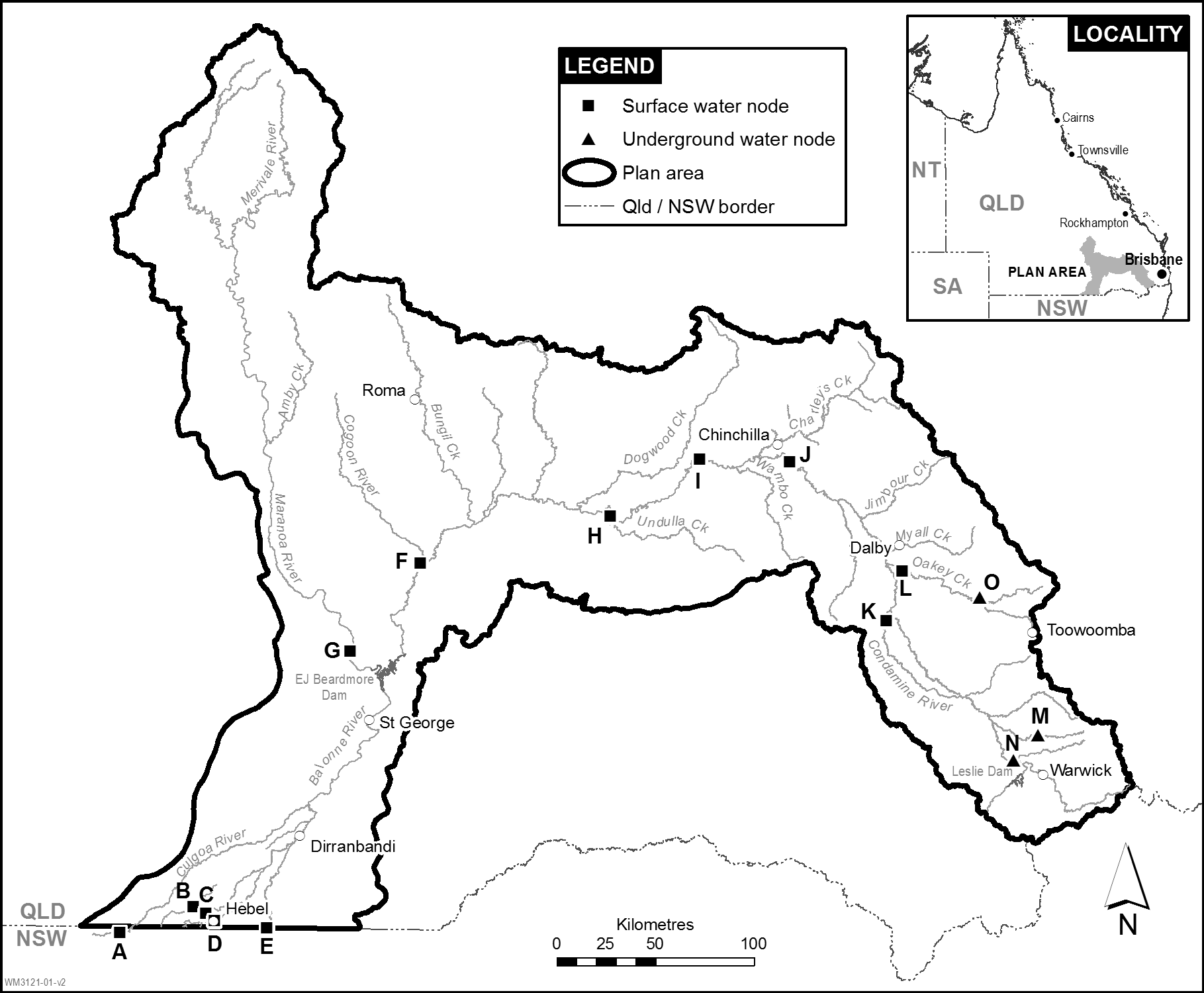
Node | Modelled locations |
A | the Culgoa River at Brenda gauging station in New South Wales (422015) |
B | Briarie Creek at Woolerbilla-Hebel Road gauging station (422211A) |
C | the Ballandool River at Hebel-Bollon Road gauging station (422207A) |
D | the Bokhara River at Hebel gauging station (422209A) |
E | the Narran River at border of Queensland and New South Wales |
F | the Balonne River at Weribone gauging station (422213A) |
G | the Maranoa River at Cashmere gauging station (422404A) |
H | the Condamine River at Cotswold gauging station (422325A) |
I | the Condamine River at Bedarra gauging station (422344A) |
J | the Condamine River at Brigalow gauging station (422336A) |
K | the Condamine River at Cecil Plains gauging station (422316A) |
L | Oakey Creek at Fairview gauging station (422350A) |
M | the model node 19266 |
N | the model node 9436 |
O | the model node 67002 |
Column 1 | Column 2 | Column 3 |
Upper Condamine | UCS-01 | Sandy Creek, from the upstream extent of the ponded area of Leslie Dam (AMTD 20.0km) downstream to the confluence with the Condamine River (AMTD 0.0km). |
UCS-02 | The Condamine River, from the confluence of Sandy Creek (AMTD 1077.9km) downstream to Talgai Weir (AMTD 1029.3km). | |
UCS-03 | The Condamine River North Branch, from the Yarramalong Diversion pipeline outlet (AMTD 97.0km) downstream to the end of the supplemented section (AMTD 10.0km). | |
UCS-04 | The Condamine River, from Talgai Weir (AMTD 1029.3km) downstream to Cecil Plains Weir (AMTD 891.1km). | |
Chinchilla Weir | CBS-01 | The Condamine River, from the upstream extent of the ponded area of Chinchilla Weir (AMTD 743.6km) downstream to Chinchilla Weir (AMTD 697.0km). |
CBS-02 | The Condamine River, from Chinchilla Weir (AMTD 697.0km) downstream to the confluence of Charleys Creek (AMTD 689.7km). | |
CBS-03 | The Condamine River, from the confluence of Charleys Creek (AMTD 689.7km) downstream to the confluence of Wambo Creek (AMTD 671.4km). | |
CBS-04 | The Condamine River, from the confluence of Wambo Creek (AMTD 671.4km) to the downstream extent of the Chinchilla Weir water supply scheme (AMTD 643.7km). | |
Maranoa River | MRS-01 | The Maranoa River, from the upstream extent of the ponded area of Neil Turner Weir (AMTD 229.2km) downstream to Neil Turner Weir (AMTD 222.2km). |
St George | LBS-01 | The Balonne River, from the upstream extent of the ponded area of E J Beardmore Dam (AMTD 305.0km) downstream to the Jack Taylor Weir (AMTD 229.6km) (including E J Beardmore Dam). |
LBS-02 | Thuraggi Watercourse, from the headworks on E J Beardmore Dam (AMTD 0.0km) downstream to AMTD 0.4km. | |
LBS-03 | The Balonne River, from Jack Taylor Weir (AMTD 229.6km) downstream to AMTD 197.0km. | |
LBS-04 | The Balonne River, from AMTD 197.0km downstream to Bifurcation No. 1 on the Culgoa River and the Balonne Minor River (AMTD 163.9km). |
sections 8 and 9
Column 1 | Column 2 |
UCU-01 | The Condamine River, from the headwaters of the Condamine River (AMTD 1188.0km) downstream to Scots Weir (AMTD 1105.6km). |
UCU-02 | The Condamine River, from Scots Weir (AMTD 1105.6km) downstream to the confluence of Sandy Creek (AMTD 1077.9km). |
UCU-03 | Sandy Creek, from Leslie Dam (AMTD 6.0km) downstream to the confluence of the Condamine River (AMTD 0.0km). |
UCU-04 | The Condamine River, from the confluence of Sandy Creek (AMTD 1077.9km) downstream to Talgai Weir (AMTD 1029.3km). |
UCU-05 | The Condamine River, from Talgai Weir (AMTD 1029.3km) downstream to Tummaville gauging station (AMTD 974.7km). |
UCU-06 | The Condamine River, from Tummaville gauging station (AMTD 974.7km) downstream to Yarramalong Weir (AMTD 966.2km). |
UCU-07 | The Condamine River, from Yarramalong Weir (AMTD 966.2km) downstream to Lemon Tree Weir (AMTD 943.4km). |
UCU-08 | The Condamine River, from Lemon Tree Weir (AMTD 943.4km) downstream to Hornicks Road (AMTD 917.0km). |
UCU-09 | The Condamine River, from Hornicks Road (AMTD 917.0km) downstream to Cecil Plains Weir (AMTD 891.1km). |
UCU-10 | The Condamine River, from Cecil Plains Weir (AMTD 891.1km) downstream to the confluence of the Condamine River North Branch (AMTD 880.7km). |
UCU-11 | The Condamine River North Branch, from the upstream extent of the Condamine River North Branch (AMTD 128.4km) downstream to the confluence of the Condamine River (AMTD 0.0km). |
UCU-12 | The Condamine River, from the confluence of the Condamine River North Branch (AMTD 880.7km) downstream to AMTD 843.7km. |
UCU-13 | The Condamine River, from AMTD 843.7km downstream to the confluence of Myall Creek (AMTD 829.2km). |
UCU-14 | The Condamine River, from the confluence of Myall Creek (AMTD 829.2km) downstream to the confluence of Jimbour Creek (AMTD 802.5km). |
UCU-15 | The Condamine River, from the confluence of Jimbour Creek (AMTD 802.5km) downstream to the confluence of Wilkie Creek (AMTD 779.2km). |
UCU-16 | The Condamine River, from the confluence of Wilkie Creek (AMTD 779.2km) downstream to the upstream extent of Chinchilla Weir water supply scheme (AMTD 743.6km). |
Column 1 | Column 2 |
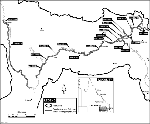
CBU-01 | The Condamine River, from the upstream extent of Chinchilla Weir water supply scheme (AMTD 743.6km) downstream to Chinchilla Weir (AMTD 697.0km). |
CBU-02 | The Condamine River, from Chinchilla Weir (AMTD 697.0km) downstream to the confluence of Wieambilla Creek (AMTD 660.8km). |
CBU-03 | The Condamine River, from the confluence of Wieambilla Creek (AMTD 660.8km) downstream to the downstream limits of Chinchilla Weir water supply scheme (AMTD 643.7km). |
CBU-04 | The Condamine River, from the downstream limits of Chinchilla Weir water supply scheme (AMTD 643.7km) downstream to Cotswold gauging station (AMTD 537.5km). |
CBU-05 | The Condamine River, from Cotswold gauging station (AMTD 537.5km) downstream to the confluence of Dogwood Creek (AMTD 507.8km). |
CBU-06 | The Balonne River, from the confluence of Dogwood Creek (AMTD 507.8km) downstream to the confluence of Yuleba Creek (AMTD 466.8km). |
CBU-07 | The Balonne River, from the confluence of Yuleba Creek (AMTD 466.8km) downstream to Surat Weir (AMTD 405.2km). |
CBU-08 | The Balonne River, from Surat Weir (AMTD 405.2km) downstream to the confluence of the Cogoon River (AMTD 359.1km). |
CBU-09 | The Balonne River, from the confluence of the Cogoon River (AMTD 359.1km) downstream to the upstream extent of St George water supply scheme (AMTD 305.0km). |
CBU-10 | Washpool Creek (AMTD 16.7km), Burraburri Creek (AMTD 49.4km) and Darr Creek (AMTD 34.2km) downstream to the confluence of Moram Creek and Burraburri Creek (AMTD 0.0km). |
CBU-11 | Nudley Creek, from the confluence of Moram Creek and Burraburri Creek (AMTD 31.9km) downstream to the confluence of Charleys Creek (AMTD 0.0km). |
CBU-12 | Charleys Creek, from the confluence of Stockyard Creek (AMTD 110.0km) downstream to the confluence of Nudley Creek (AMTD 83.9km). |
CBU-13 | Charleys Creek, from the confluence of Nudley Creek (AMTD 83.9km) downstream to the confluence of Dead Man Gully (AMTD 58.3km). |
CBU-14 | Dead Man Gully, from the Brigalow-Canaga Road (AMTD 8.7km) downstream to the confluence of Charleys Creek (AMTD 0.0km). |
CBU-15 | Charleys Creek, from the confluence of Dead Man Gully (AMTD 58.3km) downstream to Chinchilla Town Weir including Round Waterhole (AMTD 19.0km). |
CBU-16 | Rocky Creek, from the confluence of Baking Board Creek (AMTD 12.8km) downstream to the confluence of Charleys Creek (AMTD 0.0km). |
CBU-17 | Charleys Creek, from Chinchilla Town Weir (AMTD 19.0km) downstream to the confluence of the Condamine River (AMTD 0.0km). |
CBU-18 | Branch Creek, from the confluence of Horse Creek (AMTD 19.1km) downstream to the confluence of Charleys Creek (AMTD 0.0km). |
CBU-21 | The Maranoa River, from Neil Turner Weir (AMTD 222.2km) downstream to the upstream extent of St George water supply scheme (AMTD 6.5km). |
CBU-22 | The Maranoa River, from the upstream extent of Maranoa River water supply scheme (AMTD 229.2km) downstream to Neil Turner Weir (AMTD 222.2km). |
Column 1 | Column 2 |
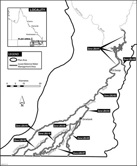
LBU-01 | The Balonne River, from the upstream extent of the ponded area of E J Beardmore Dam (AMTD 305.0km) downstream to Jack Taylor Weir (AMTD 229.6km) (including E J Beardmore Dam). |
LBU-02 | The Balonne River, from Jack Taylor Weir (AMTD 229.6km) downstream to the weir on the Culgoa River at Bifurcation No. 1 (AMTD 163.4km) and the weir on the Balonne Minor River at Bifurcation No. 1 (AMTD 163.5km) (from the upper extent of the Balonne Minor River at AMTD 164.3km where it bifurcates from the Balonne River at AMTD 163.9km). |
LBU-03 | The Culgoa River, from the weir on the Culgoa River at Bifurcation No. 1 (AMTD 163.4km) downstream to the Queensland and New South Wales border (AMTD 0.0km). |
LBU-04 | The Balonne Minor River (including Belah Creek), from the weir on the Balonne Minor River at Bifurcation No. 1 (AMTD 163.5km) downstream to the bifurcation of the Narran River and the Balonne Minor River (AMTD 128.9km). |
LBU-05 | The Narran River (including Donnegri Creek and Little Narran), from the weir on Donnegri Creek at Bifurcation No. 2 (AMTD 80.6km) downstream to the Queensland and New South Wales border (AMTD 0.0.km). |
LBU-06 | The Balonne Minor River, from the weir on the Balonne Minor River at Bifurcation No. 2 (AMTD 128.9km) downstream to the bifurcation of the Bokhara River and the Ballandool River (AMTD 91.6km). |
LBU-07 | The Bokhara River, from the weir on the Bokhara River at Bifurcation No. 3 (AMTD 80.1km) downstream to the Queensland and New South Wales border (AMTD 0.0km). |
LBU-08 | Braire Creek, from where the creek starts on the floodplain (AMTD 55.5km) downstream to the Queensland and New South Wales border (AMTD 0.0km). |
LBU-09 | Thuraggi Watercourse, from the headworks on E J Beardmore Dam (AMTD 0.0km) downstream to Buckinbah Weir (AMTD 27.4km). |
LBU-10 | The Ballandool River, from the weir on the Ballandool River at Bifurcation No. 3 (AMTD 91.6km) downstream to the Queensland and New South Wales border (AMTD 0.0km). |
Column 1 | Column 2 |
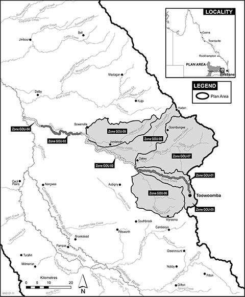
GOU-01 | Gowrie Creek, from its upstream extent (AMTD 36.7km) downstream to its confluence with Westbrook Creek (AMTD 0.0km). |
GOU-02 | Oakey Creek, from the confluence of Westbrook Creek (AMTD 82.9km) downstream to Bowenville-Norwin Road (AMTD 37.0km). |
GOU-03 | Oakey Creek, from Bowenville-Norwin Road (AMTD 37.0km) downstream to Fairview gauging station (AMTD 11.0km). |
GOU-04 | Oakey Creek, from Fairview gauging station (AMTD 11.0km) downstream to the confluence with the Condamine River (AMTD 0.0km). |
GOU-05 | The Gowrie Creek tributaries, from the upstream extent of each Gowrie Creek tributary downstream to its confluence with Gowrie Creek. |
GOU-06 | Westbrook Creek and its tributaries, from the upstream extent of Westbrook Creek and its tributaries downstream to the confluence of Gowrie Creek. |
GOU-07 | Oakey Creek and its tributaries, from the upstream extent of Oakey Creek and its tributaries downstream to the confluence of Westbrook Creek. |
GOU-08 | Doctors Creek and its tributaries, from the upstream extent of Doctors Creek and its tributaries downstream to the confluence of Oakey Creek. |
GOU-09 | Lagoon Creek and its tributaries, from the upstream extent of Lagoon Creek and its tributaries downstream to the confluence of Oakey Creek. |
Part 2 Cunningham Alluvium, Dalrymple Creek Alluvium, Oakey Creek Alluvium and Upper Hodgson Creek Basalts
sections 26 and 27
(1)An environmental flow objective for surface water to which this plan applies is that the performance indicator mentioned in subsection (2) is not less than what the performance indicator was immediately before the commencement.(2)The performance indicator, for nodes A, B, C, D, E and L, is the mean annual flow at each node as a percentage of the pre-development flow for the node.(3)In this section—mean annual flow, at a node, means the total volume of flow of water at the node in the simulation period, divided by the number of years in the simulation period.pre-development flow, for a node, means the mean annual flow at the node simulated as if—(a)there were no dams or other water infrastructure in the plan area; and(b)no water had been taken under authorisations in the plan area.
2Days in no-flow periods to support waterhole persistence
(1)An environmental flow objective for surface water to which this plan applies is that the performance indicator mentioned in subsection (2) is not more than what the performance indicator was immediately before the commencement.(2)The performance indicator, for nodes A to L, is the total number of days in all no-flow periods at each node as a percentage of the total number of days in the simulation period.(3)In this section—no-flow period means a continuous period—(a)that is greater than—(i)for nodes A to F and H—1.5 years; or(ii)for node G—1.1 years; or(iii)for nodes I and J—1.4 years; or(iv)for node K—0.9 years; or(v)for node L—0.5 years; and(b)that is during the simulation period; and(c)during which daily water flows at the node are no more than 5ML.
3Days between fish migration flow events
(1)An environmental flow objective for surface water to which this plan applies is that the performance indicator mentioned in subsection (2) is not more than what the performance indicator was immediately before the commencement.(2)The performance indicator, for nodes A to L, is the total number of days in all intervening periods for each node as a percentage of the total number of days in the simulation period.(3)In this section—fish migration flow event, for a node, means a continuous period of 1 or more days, between 1 September of a year and 31 May of the next year—(a)starting when the daily water flow at the node is more than the fish movement threshold stated for the node in the following table; and(b)ending when the daily water flow at the node is less than the fish movement threshold stated for the node in the following table.intervening period, for a node, means a period between fish migration flow events for the node that is—(a)greater than the number of years stated for the node in the following table; and(b)during the simulation period.
Node
Years
Fish movement threshold (ML/day)
A
1.5
1,500
B
1.5
690
C
1.5
320
D
1.5
1,000
E
1.5
2,100
F
1.5
7,800
G
1.1
2,100
H
1.5
21,000
I
1.4
6,500
J
1.4
8,000
K
0.9
5,300
L
0.5
2,400
4Days between floodplain inundation events
(1)An environmental flow objective for surface water to which this plan applies is that the performance indicator mentioned in subsection (2) is not more than what the performance indicator was immediately before the commencement.(2)The performance indicator, for nodes A to L, is the total number of days in all intervening periods for each node as a percentage of the total number of days in the simulation period.(3)In this section—floodplain inundation event, for a node, means a daily water flow at the node that is equal to or more than the flow rate at which the floodplain starts to fill, as stated for the node in the following table.intervening period, for a node, means a continuous period of more than 4 years and 7 months, during the simulation period, between floodplain inundation events for the node.
Node
Fill commencement threshold (ML/day)
A
8,400
B
6,100
C
10,000
D
7,100
E
17,000
F
82,000
G
2,300
H
47,000
I
22,000
J
19,000
K
52,000
L
23,000
(1)An environmental flow objective for surface water to which this plan applies is that the performance indicator mentioned in subsection (2) is not less than what the performance indicator was immediately before the commencement.(2)The performance indicator, for nodes A to L, is the total number of days with a river-forming flow at each node as a percentage of the total number of days in the simulation period.(3)In this section—river-forming flow, at a node, means a daily water flow at the node that is more than the flow threshold stated for the node in the following table.
Node
Flow threshold (ML/day)
A
8,400
B
6,100
C
610
D
2,600
E
6,000
F
34,000
G
2,300
H
43,000
I
22,000
J
19,000
K
52,000
L
23,000
(1)An environmental flow objective for underground water to which this plan applies is that, at nodes M, N and O, the performance indicator mentioned in subsection (2) is at least the water level stated for each node in the following table.
Node
10th percentile water level (mAHD)
M
467.0
N
423.8
O
374.8
(2)The performance indicator, for nodes M, N and O, is the 10th percentile water level during the simulation period.
(1)An environmental flow objective for underground water to which this plan applies is that, at nodes M, N and O, the performance indicator mentioned in subsection (2) is at least the water level stated for each node in the following table.
Node
90th percentile water level (mAHD)
M
467.9
N
425.3
O
379.1
(2)The performance indicator, for nodes M, N and O, is the 90th percentile water level during the simulation period.
sections 29, 72 and 80
Column 1 | Column 2 | Column 3 | Column 4 | Column 5 |
Underground water sub-area | Water allocation group | Available water ratio | Performance ratio | Purpose |
Oakey Creek Alluvium | UCA01 | 1.00 | 100% | urban |
UCA02 | 1.00 | 60% | any | |
UCA03 | 1.00 | 100% | productive base | |
Dalrymple Creek Alluvium | UCA04 | 1.00 | 100% | urban |
UCA05 | 1.00 | 70% | any | |
UCA06 | 1.00 | 100% | productive base | |
Cunningham Alluvium | UCA07 | 1.00 | 100% | urban |
UCA08 | 1.00 | 70% | any | |
UCA09 | 1.00 | 100% | productive base |
Column 1 | Column 2 |
Underground water unit | Annual volume (ML) |
sediments above the Great Artesian Basin | 4,500 |
Condamine Fractured Rock | 660 |
Queensland Murray-Darling Basin deep | 15,000 |
•602018
•602019
•602021
•602023
•602025
•602027
•602028
•604248
•604954
•605573
•606625
•606743
•606830
•616103
•616104
•616114
•616115
•617129
•617180
•617182
•617219
•617220
•617971
section 58, definition group S water licence
•184955
•16829R
•17520R
•18257R
•18371R
•34646R
•34969R
•35939R
•37846R
•52502R
•52937R
•52987R
•56566R
•56568R
•61233R
•87848R
Column 1 | Column 2 |
Water management area zone | Water allocation group |
UCU-01 | class CT1 |
class CT2 | |
class CT3 | |
UCU-02 | class CS1 |
class CS2 | |
class CS3 | |
UCU-03 | class CR1 |
class CR2 | |
UCU-04 | class CQ1 |
class CQ2 | |
UCU-05 | class CP1 |
class CP2 | |
UCU-06 | class CO1 |
class CO2 | |
class CO3 | |
UCU-07 | class CN1 |
class CN2 | |
class CN3 | |
UCU-08 | class CM1 |
class CM2 | |
class CM3 | |
UCU-09 | class CL1 |
class CL2 | |
class CL3 | |
UCU-10 | class CK1 |
class CK2 | |
class CK3 | |
UCU-11 | class NB1 |
UCU-12 | class CJ1 |
class CJ2 | |
UCU-13 | class CI1 |
class CI2 | |
UCU-14 | class CH1 |
class CH2 | |
UCU-15 | class CG1 |
class CG2 | |
UCU-16 | class CF1 |
class CF2 | |
CBU-01 | class CE1 |
class CE2 | |
CBU-02 | class CD1 |
class CD2 | |
CBU-03 | class CC1 |
class CC2 | |
CBU-04 | class CB1 |
class CB2 | |
class CB3 | |
CBU-05 | class CA1 |
class CA2 | |
CBU-06 | class BD1 |
class BD2 | |
CBU-07 | class BC1 |
class BC2 | |
CBU-08 | class BB1 |
class BB2 | |
CBU-09 | class BA1 |
class BA2 | |
CBU-10 | class CTR1 |
class CTR2 | |
CBU-11 | class N1 |
class N2 | |
CBU-12 | class CCD1 |
class CCD2 | |
CBU-13 | class CCC1 |
class CCC2 | |
CBU-14 | class DM1 |
class DM2 | |
CBU-15 | class CCB1 |
class CCB2 | |
CBU-16 | class R1 |
class R2 | |
CBU-17 | class CCA1 |
class CCA2 | |
CBU-18 | class B1 |
class B2 | |
CBU-21 | class ML1 |
class ML2 | |
CBU-22 | class MS1 |
class MS2 | |
GOU-01 | class WM1 |
class GA1A | |
class GA1B | |
class GA1C | |
class GB1A | |
class GB1B | |
class GB1C | |
GOU-02 | class WM1 |
class GA2 | |
class GB2 | |
GOU-03 | class WM1 |
class GA3 | |
class GB3 | |
GOU-04 | class WM1 |
class GA4 | |
class GB4 | |
GOU-05 | class WT5 |
class GT5 | |
GOU-06 | class WT6 |
class GT6 | |
GOU-07 | class WT7 |
class GT7 | |
GOU-08 | class WT8 |
class GT8 | |
GOU-09 | class WT9 |
class GT9 | |
LBU-01 | class LB1 |
LBU-02 | class LB2 |
LBU-03 | class LB3 |
LBU-04 | class LB4 |
LBU-05 | class LB5 |
LBU-06 | class LB6 |
LBU-07 | class LB7 |
LBU-08 | class LB8 |
LBU-10 | class LB10 |
CBT-01 | class 1A |
class 1B | |
CBT-02 | class 2A |
class 2B | |
CBT-03 | class 3A |
class 3B | |
CBT-04 | class 4A |
class 4B | |
CBT-05 | class 5A |
class 5B | |
class 5C | |
CBT-06 | class 6A |
class 6B | |
CBT-07 | class 7A |
class 7B | |
class 7C | |
CBT-08 | class 8A |
class 8B | |
class 8C | |
CBT-09 | class 9A |
class 9B | |
class 9C |
Column 1 | Column 2 |
Water allocation | Detail or condition |
6 on AP7585 | Water allocation group: class BD1 |
7 on AP7585 | Water allocation group: class BD1 |
26 on AP7585 | Water allocation group: class CC1 |
48 on AP7585 | Water allocation group: class N1 |
60 on AP7585 | Water allocation group: class CB2 |
74 on AP7585 | Water allocation group: class CB2 |
75 on AP7585 | Water allocation group: class CB2 |
76 on AP7585 | Water allocation group: class CB2 |
77 on AP7585 | Water allocation group: class CB2 |
78 on AP7585 | Water allocation group: class CE2 |
82 on AP7585 | Water allocation group: class CE2 |
83 on AP7585 | Water allocation group: class CE2 |
95 on AP7585 | Water allocation group: class CCB2 |
107 on AP7585 | Water allocation group: class R2 |
117 on AP7585 | Water allocation group: class B2 |
118 on AP7585 | Water allocation group: class B2 |
119 on AP7585 | Water allocation group: class 4B |
122 on AP7585 | Water allocation group: class CTR2 |
123 on AP7585 | Water allocation group: class CCA2 |
191 on AP7585 | Water management area zone: UCU-13 |
194 on AP7585 | Water management area zone: UCU-13 |
195 on AP7585 | Water management area zone: UCU-13 |
196 on AP7585 | Water allocation group: class CJ1 |
197 on AP7585 | Water allocation group: class CJ1 |
198 on AP7585 | Water allocation group: class CJ1 |
200 on AP7585 | Water allocation group: class CJ1 |
204 on AP7585 | Water management area zone: UCU-10 |
206 on AP7585 | Water allocation group: class CK2 |
229 on AP7585 | Water allocation group: class CN1 |
246 on AP7585 | Water allocation group: class CO2 |
247 on AP7585 | Water allocation group: class CO2 |
300 on AP7585 | Water allocation group: class CF2 |
308 on AP7585 | Water allocation group: class CH2 |
313 on AP7585 | Water allocation group: class CI2 |
315 on AP7585 | Water allocation group: class CI2 |
316 on AP7585 | Water allocation group: class CI2 |
317 on AP7585 | Water allocation group: class CI2 |
318 on AP7585 | Water allocation group: class CI2 |
319 on AP7585 | Water allocation group: class CI2 |
320 on AP7585 | Water management area zone: UCU-13 |
321 on AP7585 | Water allocation group: class CI2 |
322 on AP7585 | Water allocation group: class CJ2 |
325 on AP7585 | Water allocation group: class CJ2 |
339 on AP7585 | Water allocation group: class CS2 |
364 on AP7585 | Water allocation group: class CT2 |
374 on AP7585 | Water allocation group: class CT2 |
377 on AP7585 | Water allocation group: class CT2 |
382 on AP7585 | Water allocation group: class CT2 |
554 on AP7585 | Water allocation group: class 2B |
601 on AP7585 | Water management area zone: UCU-05 |
602 on AP7585 | Water management area zone: UCU-05 |
603 on AP7585 | Water management area zone: UCU-05 |
613 on AP7585 | Water allocation group: class 7B |
614 on AP7585 | Water allocation group: class 7B |
615 on AP7585 | Water allocation group: class 7B |
616 on AP7585 | Water allocation group: class 7B |
626 on AP7585 | Location of take: Hodgson Creek AMTD 35.0km |
649 on AP7585 | Water allocation group: class 7B |
875 on AP7585 | Water allocation group: class 9B |
1701 on AP7585 | Water management area zone: CBT-01 |
1706 on AP7585 | Water allocation group: class CS2 |
adopted middle thread distance means the distance in kilometres, measured along the middle of a watercourse, from a specific point in the watercourse to the watercourse’s mouth, the watercourse’s junction with the main watercourse or the border between the State and New South Wales.
AMTD means adopted middle thread distance.
authorisation means—
(a)a water allocation, water licence, water permit, seasonal water assignment notice or other authority to take water given under the Act or the repealed Act, other than a water permit for stock purposes or domestic purposes; or
(b)a water licence, resource operations licence or distribution operations licence to interfere with water given under the Act or the repealed Act; or
(c)an authority to take water given under another Act.
available water ratio, for a water allocation group, means the ratio of the average annual volume of water available for all water allocations in the group, to the total volumetric limit of all water allocations in the group.
average annual volume, of water, means the volume of the water expressed as a long-term modelled average over the simulation period for the water.
average volume means—
(a)for surface water—the total volume of surface water simulated, using the eWater Source computer program, to have been taken during the simulation period for surface water under all authorisations in the plan area included in the computer program, divided by the number of years in the simulation period; or
(b)for underground water—(i)the total volume of underground water simulated, using the MODFLOW computer program, to have been taken during the simulation period for underground water under all authorisations in the plan area included in the computer program, divided by the number of years in the simulation period; or(ii)the estimated volume divided by 100.
certified report means a report that—
(a)is verified and signed by a registered professional engineer under the Professional Engineers Act 2002; and
(b)for a certified report about works used, or capable of being used, to take overland flow water, describes—(i)the nature and location of the works; and(ii)how the works operate; and(iii)the ability of the works to take the water.
daily water flow, at a node, means the volume of water that flows past the node in a day.
decision, for part 7, see section 32.
estimated volume means the total volume of underground water estimated by the chief executive—
(a)to have been taken, during any continuous 100-year period, under all authorisations in the plan area, other than authorisations mentioned in definition average volume, paragraph (b)(i) or water licences to which water sharing rules do not apply; and
(b)having regard to the following matters as at the commencement—(i)the volumetric limits applying to the authorisations;(ii)the water sharing rules for the authorisations;(iii)the conditions imposed on the authorisations.
eWater Source computer program means the eWater Source computer program used by the department to simulate daily stream flows, flow management, storages, releases, in-stream infrastructure, water diversions, water demands and other hydrological events in the plan area.
existing authorisation, in relation to a water allocation, means the authorisation from which the water allocation was converted.
existing overland flow works means overland flow works used, or capable of being used, to take overland flow water to which this plan applies, other than for stock purposes or domestic purposes, if the works—
(a)were in existence on 20 September 2000; or
(b)were started, but not finished, by 20 September 2000 and were completed by—(i)if a moratorium notice stated the works must be completed by a day (the completion day), and a variation of the moratorium notice to extend the completion day was granted—the day stated in the notice of decision given for the variation under section 27(5)(b) of the Act, as in force immediately before 6 December 2016; or(ii)otherwise—30 November 2001; or
(c)replace, or are a reconfiguration of, works mentioned in paragraph (a) or (b) if the replacement or reconfiguration of the works did not increase the average annual volume of overland flow water to which this plan applies capable of being taken by the works.
flow threshold means a requirement about flow rate, the water level of a flow or flow duration.
flow management arrangement means an arrangement mentioned in section 82(2)(g) and stated in the water management protocol for this plan.
group S water licence, for part 10, division 6, see section 58.
irrigated area, for an existing authorisation, means the area, stated in the existing authorisation, that was able to be irrigated by water taken under the existing authorisation.
Lower Balonne means—
(a)the impoundment of Beardmore Dam; and
(b)the watercourses in the plan area downstream of the dam; and
(c)the part of the plan area, downstream of the dam, over which floodwater from the Balonne River and its distributory streams intermittently flows.
MODFLOW computer program means the MODFLOW computer program used by the department to simulate the flow of underground water, water extractions, water demands, operational management and other hydrological events in the plan area.
moratorium notice means a moratorium notice published under section 26 of the Act, as in force immediately before 6 December 2016.
node see section 15(1).
nominal entitlement see the Water Regulation 2016, section 28(1).
notified existing overland flow works means existing overland flow works for which a notice was given to the chief executive under the repealed Water Plan (Condamine and Balonne) 2004, section 46(2)(b).
overland flow works means—
(a)works used to store overland flow water, including, for example, a sump, drain, embankment, channel or pump; or
(b)works that can be used to connect 2 or more works mentioned in paragraph (a).
performance ratio, for a group of water allocations, means—
(a)if the purpose for taking water under the water allocations in the group is ‘productive base’—the average annual volume of water not available to be taken by holders of all water allocations in the group in the simulation period expressed as a percentage of the total of the nominal volume for all water allocations in the group; or
(b)otherwise—the average annual volume of water that may be taken by holders of all water allocations in the group in the simulation period expressed as a percentage of the total of the nominal volume for all water allocations in the group.
relevant operating arrangements, for existing overland flow works, means the arrangements under which the works were operated, that were in place immediately before—
(a)if the works were in existence on 20 September 2000—that date; or
(b)for works started, but not finished, by 20 September 2000—(i)if a moratorium notice stated the works must be completed by a day (the completion day) and a variation of the moratorium notice to extend the completion day was granted—the day stated in the notice of decision given for the variation under section 27(5)(b) of the Act, as in force immediately before 6 December 2016; or(ii)otherwise—30 November 2001.
relevant version of the Basin Plan, in relation to a provision of this plan, means the Basin Plan 2012 (Cwlth) as in force 2 years before the provision was given to the Minister under the Water Act 2007 (Cwlth), section 63(3)(c).
The Basin Plan 2012 (Cwlth) is made under the Water Act 2007 (Cwlth).
relevant water licence, for part 10, division 6, see section 58.
replacement water bore see the Water Regulation 2016, schedule 19.
simulation period means—
(a)for surface water to which this plan applies—the period from 1 July 1895 to 30 June 2013; or
(b)for underground water to which this plan applies—the period from 1 July 1895 to 30 June 2016.
surface water see section 4.
sustainable diversion limits means the long-term average sustainable diversion limits under the relevant version of the Basin Plan.
trading zone means an area stated to be a trading zone for water allocations under this plan.
underground water management area see section 10.
underground water sub-area see section 11(2).
underground water sub-unit see section 12(2).
underground water unit see section 12(1).
underground water zone see section 13(2).
unsupplemented surface water means surface water to which this plan applies that is not supplemented water within the meaning of the Water Regulation 2016, schedule 19.
variation, of a moratorium notice, means the variation of the moratorium notice under section 27 of the Act as in force immediately before 6 December 2016.
volumetric limit, for a water licence, means the maximum volume of water, in megalitres, that may be taken under the licence during a water year.
water management area zone see section 9(2).
water supply scheme zone see section 7(3).