QueenslandSurveyandMappingInfrastructureAct2003SurveyandMappingInfrastructureRegulation2004Current as at 25 June 2010Reprint noteThis is the last
reprint before repeal. Repealed on 22 August 2014 by 2014SL No.
182 s 31.
Information about this reprintThis
regulation is reprinted as at 25 June 2010. The reprint—•shows the law as amended by all
amendments that commenced on or before that day(Reprints Act
1992 s 5(c))•incorporatesallnecessaryconsequentialamendments,whetherofpunctuation,numbering or
another kind (Reprints Act 1992 s 5(d)).The reprint
includes a reference to the law by which each amendment was
made—see listof legislation and list of annotations in
endnotes. Also see list of legislation for anyuncommenced
amendments.This page is specific to this reprint. See
previous reprint for information about earlierchanges made under
the Reprints Act 1992. A table of reprints is included in the
endnotes.Also see endnotes for information
about—•when provisions commenced•editorial changes made in earlier
reprint.SpellingThe spelling of
certain words or phrases may be inconsistent in this reprint or
with otherreprints because of changes made in various
editions of the Macquarie Dictionary (forexample, in the
dictionary, ‘lodgement’ has replaced ‘lodgment’). Variations of
spellingwill be updated in the next authorised
reprint.Dates shown on reprintsReprints dated at
last amendmentAllreprintsproducedonorafter1July2002,authorised (that is, hard copy) and
unauthorised (that is, electronic), are dated as at the lastdate
of amendment. Previously reprints were dated as at the date of
publication. If anauthorised reprint is dated earlier than an
unauthorised version published before 1 July2002,itmeansthelegislationwasnotfurtheramendedandthereprintdateisthecommencement of the last amendment.If the
date of an authorised reprint is the same as the date shown for an
unauthorisedversion previously published, it merely means
that the unauthorised version was publishedbeforetheauthorisedversion.Also,anyrevisededitionofthepreviouslypublishedunauthorised
version will have the same date as that version.Replacement reprint dateIf the date of an
authorised reprint is the same as the dateshown on another
authorised reprint it means that one is the replacement of the
other.
Survey and Mapping Infrastructure Regulation
2004Part 1 Preliminary[s 1]Survey
and Mapping Infrastructure Regulation2004[as
amended by all amendments that commenced on or before 25 June
2010]Part 1Preliminary1Short
titleThisregulationmaybecitedastheSurveyandMappingInfrastructure
Regulation 2004.2CommencementThis regulation
commences on 1 August 2004.3DefinitionsThe dictionary
in schedule 2 defines particular words used inthis
regulation.Current as at 25 June 2010Page
3
Survey
and Mapping Infrastructure Regulation 2004Part 2 Principles
to be applied in carrying out surveys[s 4]Part
2Principles to be applied incarrying out surveysDivision 1All
surveys4Importance of State survey and mapping
infrastructureThe State survey and mapping infrastructure
is of value to thecommunitybecauseitcontributestotheState’seconomic,environmental and social development.5How a survey contributes to the State
survey andmapping infrastructureAsurveycontributestotheStatesurveyandmappinginfrastructureby,forexample,ensuringeachofthefollowing—(a)survey observations for achieving an
acceptable level ofsurvey quality are made;(b)thesurveymarksplaced,orthesurveymarksusedasreferencepointsforthesurvey,providepermanentphysical evidence of the survey;(c)thephysicalintegrityofthesurveymarksusedisappropriate for the survey’s intended
purpose;(d)the survey observations made and
survey marks placedcomply with the relevant survey
standards;(e)thesurveyrecordsforthesurveycontainacleardescription of
the survey marks placed;(f)ifasurveymarkfromanothersurveyhasbeenincorrectly
placed or disturbed, details of the mark arerecorded in an
appropriate document;Examples of an appropriate
document—•a State
dataset•the land registry kept under a
registration ActPage 4Current as at 25
June 2010
Survey and Mapping Infrastructure Regulation
2004Part 2 Principles to be applied in carrying
out surveys[s 6](g)relevantinformationaboutthesurveyandthesurveymarks placed are
recorded in a State dataset;(h)a
surveyor accepts responsibility for the survey quality.6When a survey is of value for a survey
and mappinginfrastructure purpose(1)A
survey is of value for a survey and mapping infrastructurepurpose if, for example, the survey—(a)produces information in a form that
can be recorded in aState dataset; or(b)places permanent survey marks; or(c)makes measurements between permanent
survey marks;or(d)makesmeasurementsthatestablishtherelationshipbetweenthegeodeticreferenceframeworkandasubsidiary framework.Example of a subsidiary framework—cadastral boundary system(2)Subsection (1) does not limit the
power of—(a)thechiefexecutiveindeciding,undersection34(1),51(3)(b)or56(1)oftheAct,whetherasurvey,orinformation about a survey, is of value for
a survey andmapping infrastructure purpose; or(b)a surveyor in deciding, under section
55(1) of the Act,whether a survey is of value for a survey
and mappinginfrastructure purpose.7Intended purpose of survey(1)Asurveymustbecarriedoutinawaythatachievesthesurvey’s intended purpose.(2)Thesurvey’sintendedpurposemaybeachievedby,forexample—Current as at 25 June 2010Page
5
Survey
and Mapping Infrastructure Regulation 2004Part 2 Principles
to be applied in carrying out surveys[s 8](a)depicting on the plan of survey the
spatial location andextent of the features surveyed;
and(b)establishing appropriate survey marks
for the survey by,for example—(i)placing survey mark of a type complying with
therelevant survey standard; or(ii)usingexistingsurveymarksasreferencepoints;and(c)achievinganacceptablelevelofsurveyqualitythatisappropriate for the survey’s intended
purpose; and(d)identifying,describinganddepicting,asappropriate,naturalfeaturesthataretidalboundariesornon-tidalboundaries of
land.8Integrating survey and mapping
information(1)Asurveymustbecapableofbeingintegratedwithothersurveys.(2)Theintegrationmaybeachievedby,forexample,ensuringappropriateconnectionsaremadetothefollowingwhencarrying out the survey—(a)the
geodetic reference framework;(b)a
subsidiary framework;Example—cadastral boundary system(c)a natural feature forming a boundary
of land, includingif appropriate the former location of a
natural feature ifthe former location still forms a boundary
of land;(d)a permanent improvement on the
land.Page 6Current as at 25
June 2010
Division 2Survey and
Mapping Infrastructure Regulation 2004Part 2 Principles
to be applied in carrying out surveys[s 9]Cadastral surveys9Application of div 2Thisdivisionappliestoacadastralsurveyinadditiontodivision 1.10Boundary locations(1)Theplanofacadastralsurveymust,foraparceloflandsurveyed—(a)describeandshowthelocationofeachexistingboundary of the land; and(b)if the survey is carried out for
registering an interest inthe land—describe and show each
boundary of the landthe subject of the interest.(2)A boundary of land is shown on the
plan by recording—(a)each of the following things used as
reference points forthe survey—(i)permanent improvements on the land;(ii)existing survey
marks;(iii)surveymarksplacedincarryingoutthesurvey;and(b)the length and direction of the
boundary.(3)A boundary of land must be marked on
the land in a way thata person on the land can identify the
boundary.(4)However, subsection (3) does not apply
if—(a)theclientofthesurveyormarkingtheboundarygivesthesurveyorwrittennoticethattheclientdoesnotrequiretheboundarytobemarkedasrequiredbysubsection (3); and(b)the
surveyor complies with the relevant survey standardfor
the marking; andCurrent as at 25 June 2010Page
7
Survey
and Mapping Infrastructure Regulation 2004Part 2 Principles
to be applied in carrying out surveys[s 11](c)thereferencepointsusedforthesurveyincludearecognisedpermanentsurveymarkplacedincarryingout a State
control survey.11Taking account of parties’ rights and
obligations(1)A cadastral surveyor carrying out a
cadastral survey must, inidentifying or marking a boundary of
land, take account of therights and obligations of each party
affected by the boundary.Examples of a party affected by the
boundary—•an owner of land
sharing the boundary•an owner of land near the boundary if
the owner’s understanding ofthe position of
the boundaries of the owner’s land may change as aresult of reinstating the boundary•anowneroflandbenefitedbyaneasementiftheowner’sunderstanding of the position of the
boundaries of the easementmay change as a result of reinstating
the boundary(2)This may be achieved by, for example,
ensuring each of thefollowing—(a)cadastralboundariesarereinstatedinaccordancewiththe
hierarchy of reinstatement evidence;(b)cadastralboundariesaredefinedbyabuttalswithnogaps between, or overlaps of, the
boundaries;(c)how to decide the position of a
natural feature forming aboundary is recorded on the
plan;(d)ifthereisanapparentirregularityininformationrecorded for an
existing survey mark, the irregularity isrecorded
in—(i)a State dataset; or(ii)the land
registry kept under a registration Act;Example of an
apparent irregularity—observations made
by the surveyor relating to the survey markdiffer from the
information recorded for the mark in a StatedatasetPage
8Current as at 25 June 2010
Survey and Mapping Infrastructure Regulation
2004Part 2 Principles to be applied in carrying
out surveys[s 12](e)any
encroachment is identified and, if the encroachmentissubstantial,eachowneroflandaffectedbytheencroachment is
notified.(3)In this section—hierarchyofreinstatementevidencemeansasetofrulesrecognised in the surveying
profession—(a)forgivingweighttoevidenceofcadastralboundaries;and(b)used in the reinstatement of cadastral
boundaries.12Importance of cadastral surveys for
cadastral boundarysystem(1)A
cadastral survey contributes to—(a)themaintenanceandimprovementofcadastralboundaries
throughout the State; and(b)the information
held in—(i)a State dataset; or(ii)the land
register kept under a registration Act.(2)This
may be achieved by, for example, ensuring each of thefollowing, for the survey—(a)survey observations for achieving an
acceptable level ofsurvey quality are made;(b)surveymarksplaced,orthesurveymarksusedasreferencepointsforthesurvey,providepermanentphysical evidence of the survey;(c)thephysicalintegrityofthesurveymarksusedisappropriate for the survey’s intended
purpose;(d)the way survey observations are made
and survey marksare placed complies with the relevant survey
standards;(e)thesurveyrecordsforthesurveycontainacleardescription of
the survey marks placed;Current as at 25 June 2010Page
9
Survey
and Mapping Infrastructure Regulation 2004Part 3 Geodetic
reference framework[s 13](f)permanentsurveymarksareplacedtoassistfuturereinstatement;(g)the
survey records for the survey are kept in—(i)a
State dataset; or(ii)the land
registry kept under a registration Act;(h)the
cadastral surveyor for the survey—(i)accepts responsibility for the survey
quality; and(ii)keepssurveyrecordsforthesurveyinaformsuitable as a record of the survey.Part
3Geodetic reference framework13Geodetic reference framework(1)The geodetic reference framework
prescribed for section 6(4)of the Act
is—(a)for latitude and longitude—GDA 94;
and(b)for mapping projection—MGA 94.(2)In this section—GDA94meansthe‘GeocentricDatumofAustralia1994’(commonly called ‘GDA 94’) notified in the
CommonwealthGovernmentGazetteNo.GN35on6September1995,atpage
3369.MGA94meansthe‘MapGridAustralia1994’(commonlycalled‘MGA94’)mentionedintheGeocentricDatumofAustraliaTechnicalManual,publishedbytheIntergovernmental Committee of Surveying and
Mapping.Editor’s note—Geocentric Datum of Australia Technical
Manual, version 2.2, may beaccessedontheinternetatthewebsiteoftheIntergovernmentalPage 10Current as at 25 June 2010
Survey and Mapping Infrastructure Regulation
2004Part 4 Provisions about survey standard and
survey guideline matters[s 14]CommitteeofSurveyingand<www.icsm.gov.au/icsm/gda/gdatm/index.html>.MappingatPart
4Provisions about surveystandard and
survey guidelinematters14Matter for which a survey standard may be
madeAsurveystandardmaybemadeaboutthesupervisionofpersons carrying out cadastral
surveys.15Placing and reinstating survey
marks(1)Apersonmustnotplaceorreinstateasurveymarkforacadastral survey
unless the person is—(a)a cadastral
surveyor; or(b)a registered person supervised by a
cadastral surveyor.Maximum penalty—20 penalty units.(2)A person must not place or reinstate a
permanent survey markfor a survey unless the person
is—(a)a surveyor; or(b)a
person supervised by a surveyor.Maximum
penalty—20 penalty units.16New
boundaries(1)Information derived from an existing
survey, whether or notmadeforcadastralpurposes,maybeusedbyacadastralsurveyor in defining a boundary.(2)However, the cadastral surveyor is
responsible for—(a)the accuracy of the information used;
andCurrent as at 25 June 2010Page
11
Survey
and Mapping Infrastructure Regulation 2004Part 4 Provisions
about survey standard and survey guideline matters[s
17](b)the adequacy of the survey marks used
for the survey.17Preparing plans without carrying out a
cadastral survey(1)Acadastralsurveyormayprepareaplanofsurveyforacadastral survey without carrying out
the survey if—(a)the plan is prepared from information
from an existingsurvey, whether or not made for cadastral
purposes; and(b)theareaanddimensionsofthelandaresufficientlyaccurate for the
plan’s intended purpose.Example of intended purpose—to register an interest in land(2)If a cadastral surveyor prepares a
plan under subsection (1)—(a)the plan must be
in the approved form and signed by thesurveyor;
and(b)the surveyor must endorse the plan to
the effect that itwas prepared under this section.(3)The cadastral surveyor is responsible
for the accuracy of theinformation used for preparing the
plan.18Reinstating existing boundaries(1)This section applies if a cadastral
surveyor carries out, or isresponsibleforcarryingout,acadastralsurvey,includingasurveycommonlycalledinthesurveyingprofessionanidentificationsurvey,tofindoutthepositionofanexistingboundary on
land.(2)The cadastral surveyor must do each of
the following—(a)lookforevidenceoftheboundarybyfindingoutthepositions and descriptions of existing
survey marks andpermanentimprovementsonthelandthathavebeenused
to define the boundary;(b)give primary
consideration to the existing survey marks,unless other
evidence suggeststhattheexistingmarkswere
incorrectly placed or have been disturbed;Page 12Current as at 25 June 2010
Survey and Mapping Infrastructure Regulation
2004Part 4 Provisions about survey standard and
survey guideline matters[s 18]Examples of
other evidence—•the original
measurements•the position of a permanent
improvement on the land•a statement by an
occupier of the land(c)if the surveyor
decides that a survey mark has not beenplaced as
originally intended—(i)recordthepositionofthemarkbeingreinstated;and(ii)reinstatethemarkaccordingtotheoriginalintentions;(d)if a
doubt or discrepancy arises in relation to the placingof a
survey mark, include in the survey records—(i)a
clear description of the survey mark; and(ii)sufficientinformationtoshowthedoubtordiscrepancy; and(iii)iftheplanofsurveyistoberegisteredunderaregistrationAct—sufficientinformationtoenablethe registering
entity to register the plan;(e)decide whether or not the position of a
natural featureforming a boundary of the land is
significantly differentfrom the position marked on the
registered plan for theland;Example—A cadastral surveyor may be required
to decide whether or notthe location at law of a tidal or
non-tidal boundary, as providedfor in part 7 of
the Act, is consistent with the boundary’s positionas
marked on the registered plan for the land.(f)record any encroachments on the land;(g)findoutandrecordthepositionofanypermanentimprovements on
the land that affect, or are affected by,a reinstated
boundary.Maximum penalty—10 penalty units.(3)In this section—Current as at 25
June 2010Page 13
Survey
and Mapping Infrastructure Regulation 2004Part 4 Provisions
about survey standard and survey guideline matters[s
19]registered planmeans a plan
registered under a registrationAct.19Procedure after reinstating existing
boundaries(1)This section applies if a cadastral
surveyor—(a)reinstates a boundary in carrying out
a cadastral surveymentioned in section 18(1); and(b)considers an owner of land may be
adversely affected bythe reinstatement.(2)The
surveyor must—(a)withoutdelay,takeallreasonablestepstogivetheowner written notice of the intention to
register the planwith the reinstated boundary; and(b)advise the registering entity of the
steps taken to notifythe owner.Maximum
penalty—10 penalty units20Requirements for
cadastral plans(1)Acadastralsurveyorwhocarriesout,orisresponsibleforcarryingout,acadastralsurveymustgivetherelevantperson—(a)the plan of survey; and(b)a certificate in the approved form
signed by the cadastralsurveyor; and(c)any
other document reasonably required by the relevantperson,includinganydocumentsuppliedfordemonstrating consistency with the
public interest underpart 7 of the Act.Maximum
penalty—20 penalty units.(2)In this
section—relevant personmeans—Page
14Current as at 25 June 2010
Survey and Mapping Infrastructure Regulation
2004Part 4 Provisions about survey standard and
survey guideline matters[s 21](a)for
a plan of survey registered, lodged for registration,ordepositedunderaregistrationAct—theregisteringentity;
or(b)for a plan not mentioned in paragraph
(a) and given tothechiefexecutiveundersection16oftheAct—thechief
executive.21Survey accuracyAcadastralsurveyorwhocarriesout,orisresponsibleforcarryingout,acadastralsurveymustensureanysurveyequipment used
for the survey is—(a)calibrated and standardised;
and(b)capable of achieving the accuracy
stated in the relevantsurvey standard for cadastral
surveys.Maximum penalty—6 penalty units.22Survey records(1)Surveyrecordsforacadastralsurveythatareregistered,lodged for
registration, or deposited, under a registration Actorgiventothechiefexecutiveundersection16oftheActmustbeaccompaniedbyacertificateintheapprovedformsigned by the cadastral surveyor for the
survey.(2)Thecadastralsurveyormust,unlessthesurveyorhasareasonableexcuse,keepfor6yearsanysurveyrecordsnotmentionedinsubsection(1),whetherornotalltheinformation from the survey records is shown
on the plan ofsurvey.Maximum
penalty—6 penalty units.Current as at 25 June 2010Page
15
Survey
and Mapping Infrastructure Regulation 2004Part 5 Watercourse
identification and non-tidal boundary (watercourse) location[s
23]Part 5Watercourse
identification andnon-tidal boundary(watercourse)
locationDivision 1Preliminary23Purpose of pt 5The purpose of
this part is to support the application of theprovisionsofpart7,division4oftheActrelatingtotheidentification of watercourses and
establishing the location atlaw of non-tidal
boundaries (watercourse).24Meaning of terms
used in pt 5If a term used in this part is defined for
part 7 of the Act, theterm has the same meaning in this part
and in schedule 1.Division 2Supporting
provisions25Diagram depicting different valley
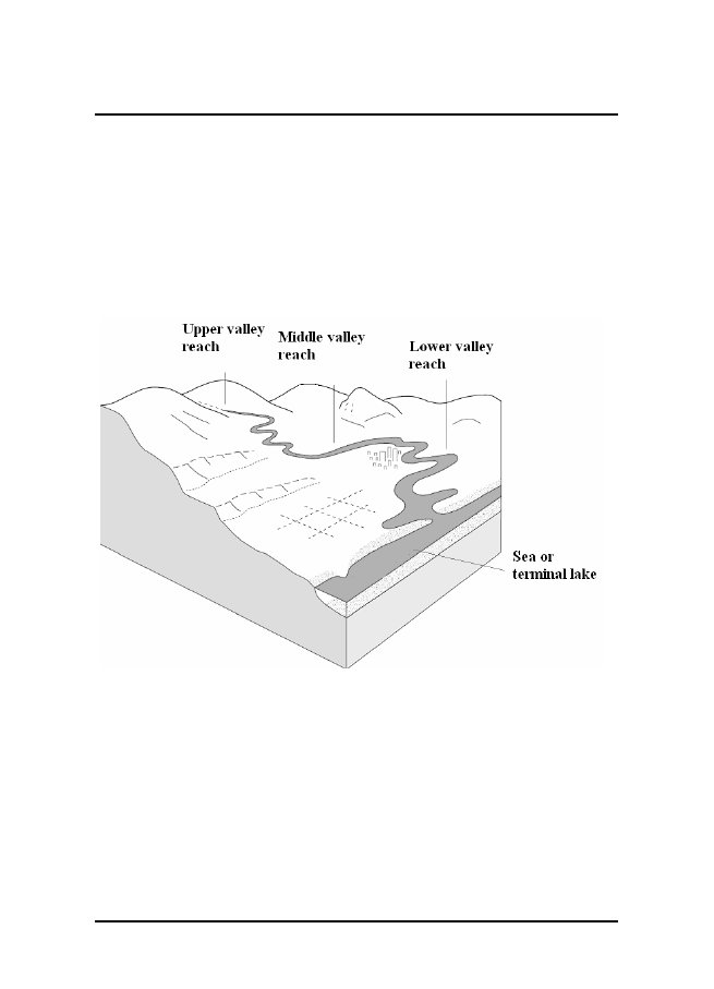
reachesDiagram A in schedule 1, part 1 depicts in
overview the upper,middleandlowervalleyreachesofavalleydrainedbyatypical
watercourse.26Explanations and accompanying
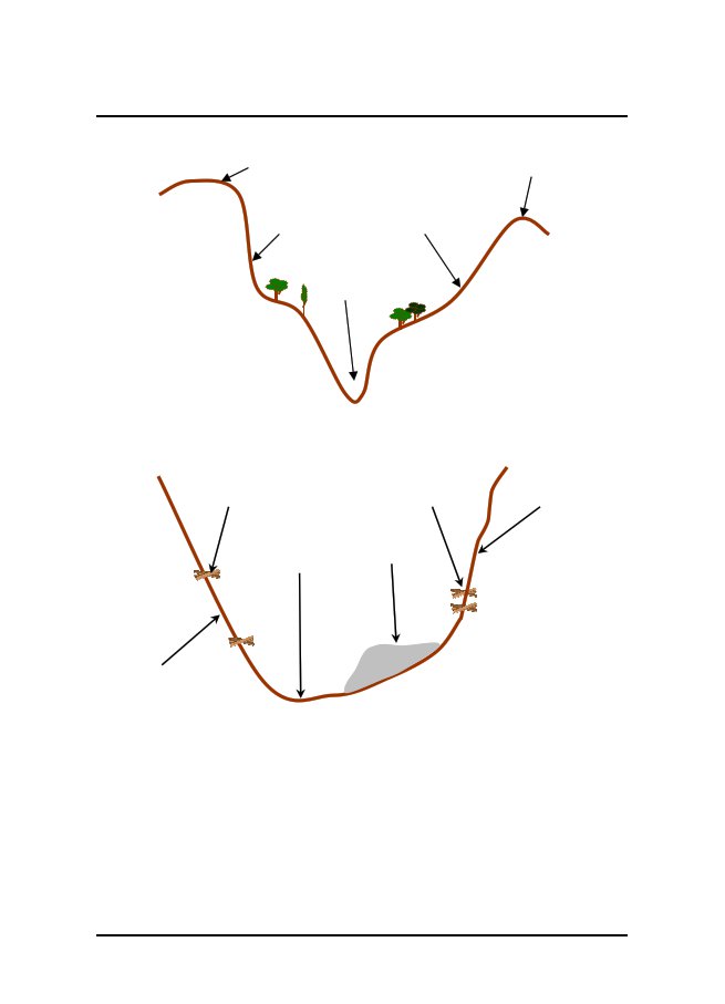
cross-section diagramsfor typical upper valley reachSchedule 1, part 2—(a)gives an explanation of the characteristics
of a typicalupper valley reach and associated
watercourse; and(b)includes a diagram (Diagram B) in
cross-section formthatdepictsthenaturalfeaturesthatarelikelytobefound in a typical upper valley reach;
andPage 16Current as at 25
June 2010
Survey and Mapping Infrastructure Regulation
2004Part 5 Watercourse identification and
non-tidal boundary (watercourse) location[s 27](c)includes a diagram (Diagram C) that
depicts the naturalfeaturesthatarelikelytobefoundinatypicalwatercourse in
an upper valley reach and that can help inlocating
non-tidal boundaries (watercourse).27Explanations and accompanying cross-section
diagramsfor typical middle valley reachSchedule 1, part 3—(a)gives an explanation of the characteristics
of a typicalmiddle valley reach and associated
watercourse; and(b)includes a diagram (Diagram D) in
cross-section formthatdepictsthenaturalfeaturesthatarelikelytobefound in a typical middle valley
reach; and(c)includes a diagram (Diagram E) that
depicts the naturalfeaturesthatarelikelytobefoundinatypicalwatercourse in a
middle valley reach and that can help inlocating
non-tidal boundaries (watercourse).28Explanations and accompanying cross-section
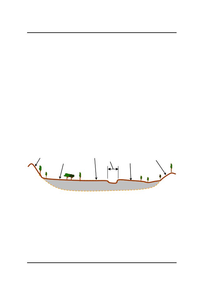
diagramsfor typical lower valley reach(1)Schedule 1, part 4—(a)gives an explanation of the
characteristics of a typicallower valley
reach and associated watercourse; and(b)includesadiagram(DiagramF)incross-sectionformthatdepictsthenaturalfeaturesthatarelikelytobefound in a typical lower valley reach;
and(c)includes a diagram (Diagram G) that
depicts the naturalfeaturesthatarelikelytobefoundinatypicalwatercourse in a
lower valley reach and that can help inlocating
non-tidal boundaries (watercourse).(2)Schedule 1, part 4 also includes—(a)adiagram(DiagramH)incross-sectionformthatdepicts the
natural features that are likely to be found inatypicallowervalleyreachwhere2ormoreCurrent as at 25
June 2010Page 17
Survey
and Mapping Infrastructure Regulation 2004Part 5 Watercourse
identification and non-tidal boundary (watercourse) location[s
29]watercourses in the form of anabranches are
containedwithin the valley; and(b)a
diagram (Diagram I) in cross-section form that depictsthe
natural features that are likely to be found in typicalwatercoursesinalowervalleyreachwherethevalleycontains2ormorewatercoursesintheformofanabranches,andthatcanhelpinlocatingnon-tidalboundaries(watercourse)inamultiplewatercourseenvironment.29Additional information about applicability
ofcross-section diagrams(1)Foranyvalley,aparticularvalleyreachcouldcontainasection of valley reach, or a section of
watercourse within asection of valley reach, that is not
typical, having regard to thevalleyreachandwatercoursecross-sectionsdepictedinschedule 1, parts 2, 3 and 4.Example—Thecross-sectionofpartofamiddlevalleyreachofaparticularwatercourse might
more closely resemble what is typical for an uppervalley reach cross-section, and the
cross-section of part of a lower valleyreach of a
particular watercourse might more closely resemble what istypical for a middle valley reach
cross-section.(2)Accordingly, a cross-section diagram
could be used to help inthe location of a non-tidal boundary
(watercourse), regardlessof the valley reach in which the
section of watercourse underconsideration is
located.30Explanation about valley
margins(1)Schedule 1 includes a number of
references to valley margins.(2)A
reference to a valley margin, in relation to a valley
drainedbyawatercourse,isintendedasareferencetothebedrockfeature that
forms a lateral extent of the valley floor.(3)Avalleymargincouldconsistofahill,cliff,ridgeormountain, but this will generally vary
according to where thevalley margin is situated in the
valley.Page 18Current as at 25
June 2010
Survey and Mapping Infrastructure Regulation
2004Part 5 Watercourse identification and
non-tidal boundary (watercourse) location[s 31]Example—A
valley margin in an upper valley reach could be a mountain, but in
alower valley reach, a valley margin is
likely to be no higher than a ridge.31Explanation about terraces(1)Schedule 1 includes a number of
references to terraces.(2)A reference to a
terrace, in relation to a valley drained by awatercourse,isintendedasareferencetoanabandonedfloodplainthatissituatedaboveanactivefloodplainassociated with
the watercourse.(3)A terrace is formed when floodplains
are abandoned duringdown cutting into the valley floor by
base level change in theformoftectonicactivity,byshiftsinsedimentloadorbychanges in the
flow regime of the watercourse.Current as at 25
June 2010Page 19
Survey
and Mapping Infrastructure Regulation 2004Schedule 1Schedule 1Valley
reachessections 25 to 28Part 1Overview of valley reachesDiagram A—Overview of valley reachesPart
2Upper valley reachExplanation of
upper valley reach and associated watercourseTheuppervalleyreachofavalleydrainedbyawatercourseistypicallylocatedinthemostelevatedpartsofthewatercoursecatchment, often
near the catchment’s watershed. The valley floorPage
20Current as at 25 June 2010
Survey and Mapping Infrastructure Regulation
2004Schedule 1istypicallyquitenarrow,characterisedbygorgesandinsomeplaces is only
as wide as the watercourse itself. The valley floor istypically quite steep, characterised by
waterfalls and cascades. Thegeneral
direction and location of the reach is dictated by the
valleymargins which appear as significant
geomorphic features.ThewatercourseistypicallynarrowanddeepwithaV-shapedprofilecarvedintothebedrock.Thelocationofthewatercoursewithin the
narrow valley floor is generally dictated by the valleymargins. The flow in the watercourse has
high velocity and highenergy,resultinginhigherosivepower.Highfloweventsareconfined within the watercourse by the
adjoining valley margins.Past flow levels are often evidenced
by scour marks on the valleymargin or the
deposition of lighter material, for example sands andtwigs, carried by the flow. The bed and
banks of the watercoursetypicallyconsistofbedrockandverycoarsematerial,includingboulders,cobblesandgravel.Themovementanddepositionofmaterial happens primarily in periods of
high flow. Flow tends torespond directly to rainfall events
and during dry periods there islittle or no
base flow. Vegetation within or along the watercourse isoftensparseorimmatureduetotheregularscouringcausedbyhigh flow energy or by the absence of
deep soil profiles.Wherethewatercourseiswider,itcouldhaveanarrowbenchadjacenttoonebankortheother.Thesebenchesaretypicallymadeoffinermaterials,commonlycobblesandgravel.Thesebenches tend to be short in length and
disconnected, and alternatefrom one side of
the watercourse to the other as the flow reboundsfrom
one valley margin to the other. These benches are regularlyreshaped by flow events.Current as at 25
June 2010Page 21
Survey
and Mapping Infrastructure Regulation 2004Schedule 1RangeValleymarginValleymarginWatercourseRidgeDiagram B—Cross sectional view of an upper
valley reachScour mark ordepositional
featureBedScour mark ordepositional
featureBenchValley
marginValley marginBedrockDiagram C—Cross sectional view of a
watercourse in an upper valley reachPart 3Middle valley reachExplanation of
middle valley reach and associated watercourseThe middle
valley reach of a valley drained by a watercourse istypically located in the watercourse
catchment’s pediment or footPage 22Current as at 25 June 2010
Survey and Mapping Infrastructure Regulation
2004Schedule 1hills.Themiddlevalleyreachisatahigherelevationthanthelower valley reach but is not as high
as the upper valley reach. Thevalley floor is
typically of moderate width, and is characterised bynarrowfloodplainsbetweenvalleymarginsoffringinghills,terracesandlowridges.Thevalleyfloorhasamoderategrade,characterisedbyameanderingwatercourseandoccasionalcascades.Thevalleyflooristypicallycomprisedofancientsedimentsdepositedbythewatercourseinearliergeologicalperiods,andcanbeinterruptedbyoccasionalbedrockridgesorbars
that are exposed in the watercourse.Thewatercoursecarriesflowfromseveraltributariesandsoistypicallydeeperandwiderthanintheuppervalleyreach.Thelocationofthewatercoursewithinthevalleyfloorisgenerallydictated by its
meander pattern and is occasionally bounded by thevalley margin. The flow in the watercourse
has less energy and isnot as fast as in the upper valley
reach. However, it has enoughenergy to
transport sediment eroded in the upper valley reach downto
the lower valley reach. Much of the sediment being
transportedistemporarilystoredinthewatercourse(typicallyasin-streambenchesandislands)oronadjacentfloodplainsbeforebeingfurthererodedandtransporteddownstreaminsubsequenthighflow
events.A number of benches are typical in the
watercourse, created by themixture of flow
size and frequency. The lower, narrower channel ofthe
watercourse is shaped by the more frequent, smaller flows
andthewider,deeperchannelofthewatercourseisshapedbylessfrequent large
flows. High flow events commonly erupt from thewatercourse onto
the adjacent floodplain. The bed and banks of thewatercoursetypicallyconsistofmediumsizedmaterial,suchascobbles,gravelandsand.Subjectalwaystolong-termweathercycles,almostperennialbaseflowsoccurbecauseoftheslowdrainageofuppersectionsofthemiddlevalleyreachandgroundwaterinflowsfromalluvialfloodplainaquifersalongthewatercourse.Vegetationwithinoralongthewatercourseiswellestablished
because of the reliable base flows and stable channelprofile.Current as at 25
June 2010Page 23
Survey
and Mapping Infrastructure Regulation 2004Schedule 1Valley marginValley
terraceHillFloodplainValley
floorValley marginWatercourseHillAncient alluvium(centuries old)BedrockDiagram D -
Cross sectional view of a middle valley reachFloodplainBenchBenchScour mark
ordepositionalSide
channelfeatureLowerInstream islandbankSand barBedValleymarginDiagram E - Cross sectional view of a
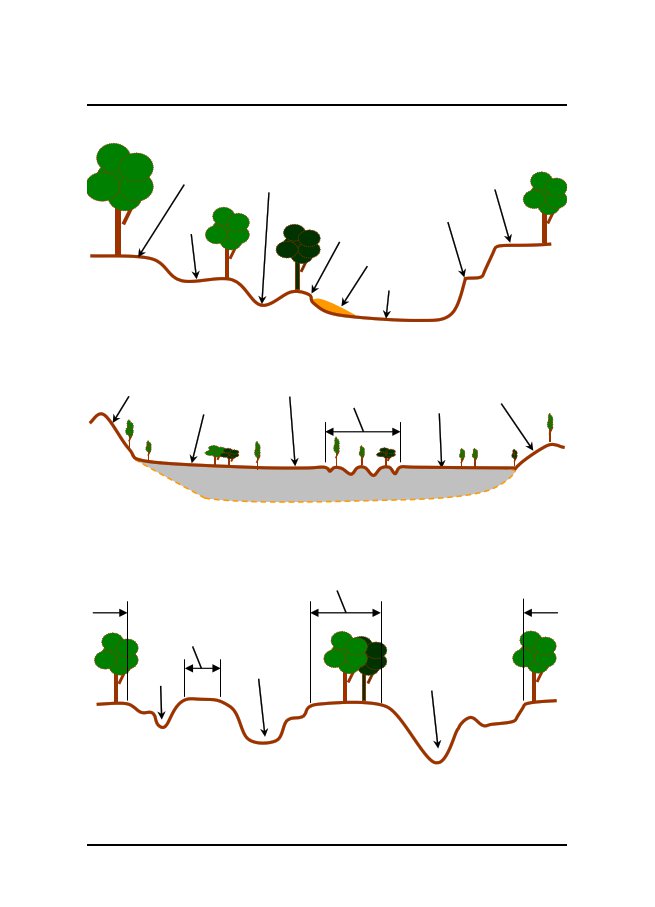
watercourse in a middle valley reachPart 4Lower
valley reachExplanation of lower valley reach and
associated watercourseThelowervalleyreachofavalleydrainedbyawatercourseistypically located in the watercourse
catchment’s lowest elevations,generallyimmediatelyupstreamofwherethewatercoursebecomes tidal or
where it flows into a natural terminal lake. Thevalley floor is quite broad, characterised
by extensive floodplainsbetweendistantvalleymarginsoffringinghillsandlowridges.Thevalleyfloorhasalowgradient,characterisedbyastronglymeanderingwatercoursewithox-bowsandoccasionalPage 24Current as at 25 June 2010
Survey and Mapping Infrastructure Regulation
2004Schedule 1anabranches.Thevalleyflooristypicallycomprisedofancientsedimentsdepositedbythewatercourseinearliergeologicalperiods.Thewatercoursegradientisquitelow,resultinginslowmovingflow.However,thewatercourseisnowcarryingwaterfromallupstreamreachesandsodissipatesthiskineticenergybymeanderingacrossthevalleyfloor,erodinganddepositingsedimentalongtheway.Thisresultsinacomparativelywide,shallow channel, often with large sediment
accumulations such asin-stream benches and islands.
Sediment that makes up the channelofthewatercourseandadjoiningfloodplainstendstobefine,commonlygravel,sandandsilt,withlowresistancetoerosion.Largeflowsresultinfloodsthatspreadacrossthefloodplains,depositingfinesediment.Perennialbaseflowsoccurbecauseofthe slow drainage of upper sections of
the lower valley reach andgroundwaterinflowsfromalluvialfloodplainaquifersalongthewatercourse.Vegetationwithinoralongthewatercourseiswellestablishedduetothereliablebaseflowsandstablechannelprofile.Valley
marginHillValley floorFloodplainWatercourseFloodplainValleymarginAncient
alluvium(centuries old)BedrockDiagram F - Cross sectional view of a lower
valley reachRidgeCurrent as at 25
June 2010Page 25
Survey
and Mapping Infrastructure Regulation 2004Schedule 1FloodplainBenchSide
channelLowerbankLowerbankSand
barBedFloodplainDiagram G -
Cross sectional view of a watercourse in a lower valley
reachValley marginValley
floorFloodplainwaMteurcltoipulresesFloodplainValleymarginHillRidgeAncient
alluvium(centuries old)BedrockDiagram H—Cross-sectional view of a lower
valley reach with multiplewatercoursesFloodplainFloodplainFloodplainFloodplainBedBedBedDiagram
I—Cross-sectional view of multiple watercourses in a lower valley
reachPage 26Current as at 25
June 2010
Schedule 2Survey and
Mapping Infrastructure Regulation 2004Schedule 2Dictionarysection 3cadastral boundary systemmeans the following—(a)informationheldbythedepartmentaboutcadastralboundaries
throughout the State;(b)survey marks
placed, or survey marks used as referencepointsforcadastralsurveys,thatprovidepermanentphysical
evidence of the surveys.encroachmentmeansanencroachmentunderthePropertyLaw Act
1974, section 182.Editor’s
note—Property Law Act 1974,
section 182 (Definitions for div 1)—encroachmentmeansencroachmentbyabuilding,includingencroachmentbyoverhangofanypartaswellasencroachmentbyintrusion of any part in or upon the
soil.permanent improvement, on land,
includes the following—(a)a
building;(b)a fence;(c)a
wall.registeredpersonmeansapersonregisteredundertheSurveyors Act 2003.registeringentity,foraplanofsurvey,meansthepersonresponsible for
registering the plan under a registration Act.registration
Actmeans theLand Act
1994orLand Title Act1994.survey records, for a survey,
means the documents necessaryto adequately
record every aspect of the survey including thefollowing—(a)a
measurement or an analysis made for, or in relation to,the
survey;Current as at 25 June 2010Page
27
Survey
and Mapping Infrastructure Regulation 2004Schedule 2(b)information about—(i)survey marks placed in carrying out the
survey; or(ii)survey marks
used as reference points in carryingout the
survey;(c)the plan of survey;(d)anyelectronicallyproducedmeasurement,analysisorplan of survey;(e)anydocumentsuppliedfordemonstratingconsistencywith the public
interest under part 7 of the Act.Page 28Current as at 25 June 2010
EndnotesSurvey and
Mapping Infrastructure Regulation 2004Endnotes1Index to endnotesPage2Date to which amendments incorporated
. . . . . . . . . . . . . . . . . . . . . . . . . . . . . . . .
.293Key . . . . . . . . . . . . . . . . .
. . . . . . . . . . . . . . . . . . . . . . . . . . . . . . . . . .
. . . . . . . . . . .294Table of reprints
. . . . . . . . . . . . . . . . . . . . . . . . . . . . . . . . . .
. . . . . . . . . . . . . . . . . .305List
of legislation . . . . . . . . . . . . . . . . . . . . . . . . . .
. . . . . . . . . . . . . . . . . . . . . . . . .306List of annotations . . . . . . . . .
. . . . . . . . . . . . . . . . . . . . . . . . . . . . . . . . . .
. . . . . . .302Date to which amendments
incorporatedThis is the reprint date mentioned in the
Reprints Act 1992, section 5(c). Accordingly, thisreprint includes all amendments that
commenced operation on or before 25 June 2010.Future amendments
of the Survey and Mapping Infrastructure Regulation 2004 may
bemade in accordance with this reprint under
the Reprints Act 1992, section 49.3KeyKey to abbreviations in list of
legislation and annotationsKeyAIAamdamdtchdefdivexpgazhdginslapnotfdnumo in comorigpparaprecpresprevExplanation=Acts
Interpretation Act 1954=amended=amendment=chapter=definition=division=expires/expired=gazette=heading=inserted=lapsed=notified=numbered=order in council=omitted=original=page=paragraph=preceding=present=previousCurrent as at 25
June 2010Key(prev)procprovptpubdR[X]RArelocrenumrep(retro)rvsschsdivSIASIRSLsubunnumExplanation=previously=proclamation=provision=part=published=Reprint No. [X]=Reprints Act 1992=relocated=renumbered=repealed=retrospectively=revised edition=section=schedule=subdivision=Statutory Instruments Act 1992=Statutory Instruments Regulation
2002=subordinate legislation=substituted=unnumberedPage
29
Survey
and Mapping Infrastructure Regulation 2004Endnotes4Table of reprintsReprints are
issued for both future and past effective dates. For the most
up-to-date tableof reprints, see the reprint with the latest
effective date.Ifareprintnumberincludesaletterofthealphabet,thereprintwasreleasedinunauthorised, electronic form only.ReprintNo.11AAmendments
includednone2010 SL No. 140Effective1
August 200425 June 2010Notes5List of legislationSurvey
and Mapping Infrastructure Regulation 2004 SL No. 130made
by the Governor in Council on 15 July 2004notfd gaz 16 July
2004 pp 856–7ss 1–2 commenced on date of
notificationremaining provisions commenced 1 August 2004
(see s 2)exp 1 September 2014 (see SIA s 54)Note—(1)The expiry date
may have changed since this reprint was published. Seethe
latest reprint of the SIR for any change.(2)An
explanatory note was prepared.amending
legislation—Environment and Resource Management
Legislation Amendment Regulation (No. 1)2010 SL No. 140,
pts 1–2notfd gaz 25 June 2010 pp 823–30commenced on date of notification6List of annotationsDefinitionss 3amd
2010 SL No. 140 s 3Intended purpose of surveys
7amd 2010 SL No. 140 s 4Integrating survey
and mapping informations 8amd 2010 SL No.
140 s 5Reinstating existing boundariess
18amd 2010 SL No. 140 s 6Requirements for
cadastral planss 20amd 2010 SL No. 140 s 7Page
30Current as at 25 June 2010