QueenslandWaterAct2000WaterResource(BurnettBasin)Plan2000Current as at 28 May 2014Reprint noteThis is the last
reprint before repeal. Repealed on 22 August 2014 by 2014SL
No. 184 s 123.
Information about this reprintThis
reprint shows the legislation current as at the date on the cover
and is authorised bythe Parliamentary Counsel.AnewreprintofthelegislationwillbepreparedbytheOfficeoftheQueenslandParliamentary
Counsel when any change to the legislation takes effect. This
change maybe because a provision of the original
legislation, or an amendment to it, commences orbecause a particular provision of the
legislation expires or is repealed.When a new reprint is prepared, this reprint will become a historical reprint. Also, if it isnecessary to replace this reprint before a new reprint is prepared, for example, to includeamendments with a retrospective commencement, an appropriate note would be includedonthecoverofthereplacementreprintandonthecopyofthisreprintatwww.legislation.qld.gov.au.The
endnotes to this reprint contain detailed information about the
legislation and reprint.For example—•The
table of reprints endnote lists any previous reprints and, for this
reprint, givesdetails of any discretionary editorial
powers under theReprints Act 1992used by
theOffice of the Queensland Parliamentary
Counsel in preparing it.•Thelistoflegislationendnotegiveshistoricalinformationabouttheoriginallegislationandthelegislationwhichamendedit.Italsogivesdetailsofuncommencedamendmentstothislegislation.Forinformationaboutpossibleamendments to the
legislation by Bills introduced in Parliament, see the
QueenslandLegislationCurrentAnnotationsatwww.legislation.qld.gov.au/Leg_Info/information.htm.•The list of annotations endnote gives
historical information at section level.All Queensland
reprints are dated and authorised by the Parliamentary Counsel.
Theprevious numbering system and distinctions
between printed and electronic reprints arenot
continued.
Water Resource (Burnett Basin) Plan
2000Part 1 Preliminary[s 1]Water Resource (Burnett Basin) Plan
2000[as amended by all amendments that commenced
on or before 28 May 2014]Part 1Preliminary1Short
titleThis water resource plan may be cited as
theWater Resource(Burnett Basin)
Plan 2000.2Purposes of
planThe following are the purposes of this
plan—(a)to define the availability of water in
the plan area;(b)to provide a framework for sustainably
managing waterand the taking of water;(c)toidentifyprioritiesandmechanismsfordealingwithfuture water requirements;(d)toprovideaframeworkforestablishingwaterallocations;(e)to
provide a framework for reversing, where practicable,degradationthathasoccurredinnaturalecosystems,including, for
example, stressed rivers.3DefinitionsThe dictionary
in schedule 9 defines particular words used inthis
plan.Current as at 28 May 2014Page
5
Water Resource (Burnett Basin) Plan
2000Part 2 Plan area and water to which plan
applies[s 4]Part 2Plan
area and water to whichplan applies4Plan
area(1)This plan applies to thearea
within the plan area boundaryshown on the
plan area map.(2)The exact location of the plan area
boundary is held in digitalelectronic form
by the department.(3)The information held in digital
electronic form can be reducedor enlarged to
show the details of the plan area boundary.Editor’s
note—The plan area boundary in digital
electronic form may be inspected atthe department’s
office at 16–32 Enterprise Street, Bundaberg.5Water
to which plan applies(1)This plan
applies to the following water (surface
water) in theplan
area—(a)water in a watercourse or lake;(b)water in springs not connected
to—(i)artesian water; or(ii)subartesian water connected to artesian
water.(2)This plan also applies to groundwater
in the Coastal Burnettgroundwater management area.Page
6Current as at 28 May 2014
Part
3Water Resource (Burnett Basin) Plan
2000Part 3 Outcomes for sustainable management
of water[s 6]Outcomes for
sustainablemanagement of waterDivision
1General outcomes6General outcomesWater is to be
managed and allocated—(a)to ensure a
reliable and secure supply of water from theplan area during
the time this plan is in force; and(b)to
allow water to be taken for the following purposes—(i)urban and industrial needs;(ii)agriculture and
aquaculture;(iii)stock and
domestic use;(iv)small scale
uses;(v)dewatering purposes; and(c)to protect the probability of being
able to obtain waterunder a water allocation; and(d)to maintain access to unsupplemented
water by holdersof authorisations to take unsupplemented
water; and(e)to provide for community aspirations
about—(i)providing for future water
requirements in the planarea; and(ii)maintainingareasofsignificantconservationvalue,
including, for example, the Auburn NationalPark and fish
habitat areas; and(iii)protectingspeciesofsignificantconservationvalue,
including, for example, lungfish and turtles;and(f)to reduce reliance on groundwater in
areas affected, orpotentially affected, by seawater intrusion;
andCurrent as at 28 May 2014Page
7
Water Resource (Burnett Basin) Plan
2000Part 3 Outcomes for sustainable management
of water[s 7](g)toreducerelianceongroundwaterinareaswhereirrigation with groundwater is detrimental
to soil; and(h)to provide for the continued use of
all water entitlementsandotherauthorisationstotakeorinterferewithgroundwater; and(i)toprovidewatersharingrulesundertheresourceoperations plan
that recognise the importance of accessto groundwater
for urban purposes; and(j)to make water
available for the environment.Division
2Ecological outcomes7Ecological outcomes for plan areaWater is to be managed and allocated—(a)to maintain pool habitats, and native
plants and animalsassociated with the habitats, in
watercourses; and(b)to maintain long term water quality
suitable for riverineand estuarine ecosystems; and(c)toprovideflowregimesthatfavournativeplantsandanimalsassociatedwithwatercoursesandriparianzones;
and(d)to provide wet season flow to benefit
native plants andanimals,including,forexample,fishandprawns,inestuaries; and(e)toimprovestreamflowconditionstoassistthemovement of fish along watercourses.8Auburn River catchmentWater in the Auburn River catchment is to be
managed andallocated—Page 8Current as at 28 May 2014
Water Resource (Burnett Basin) Plan
2000Part 3 Outcomes for sustainable management
of water[s 9](a)tomaintainexistingriverinehabitatsupstreamofAMTD6.0kmthatsustainnativeplantsandanimals;and(b)tomaintainnearnaturalriverformingprocessesupstream of AMTD
6.0km.9Barambah Creek and Stuart River
catchmentsWater in the Barambah Creek and Stuart River
catchments isto be managed and allocated to maintain and
improve existingriverine habitats, that sustain native
plants and animals, in thecatchments.10Boyne
River catchmentWaterintheBoyneRivercatchmentistobemanagedandallocated—(a)tomaintainexistingriverinehabitatsupstreamofAMTD5.0kmthatsustainnativeplantsandanimals;and(b)tomaintainandimproveexistingriverformingprocesses upstream of AMTD 5.0km.11Burnett River basin and Burnett
River(1)WaterintheBurnettRiverbasinistobemanagedandallocatedto,ifpracticable,minimisethefrequencyanddurationofmarineconditionsintheestuaryoftheBurnettRiver.(2)Water in the Burnett River is to be
managed and allocated toprovide for lungfish habitat in the
river particularly lungfishhabitat
downstream of Gayndah at AMTD 200km.12Elliott, Gregory and Isis river
basinsWaterintheElliott,GregoryandIsisriverbasinsistobemanaged and
allocated—Current as at 28 May 2014Page
9
Water Resource (Burnett Basin) Plan
2000Part 3 Outcomes for sustainable management
of water[s 13](a)to
maintain existing riverine habitats, that sustain nativeplants and animals, in the basins;
and(b)tomaintainexistingestuarinehabitats,particularlyinfish
habitat areas, that—(i)sustain native
plants and animals; and(ii)are dependant on
estuarine processes; and(c)to maintain near
natural river forming processes in thebasins.13Kolan River basinWaterintheKolanRiverbasinistobemanagedandallocated—(a)to
maintain and improve existing riverine habitats, thatsustain native plants and animals, in the
basin; and(b)tomaintainandimproveexistingestuarinehabitats,particularly in fish habitat areas,
that—(i)sustain native plants and animals;
and(ii)are dependant on
estuarine processes; and(c)to maintain and
improve river forming processes in thebasin.13ACoastal Burnett groundwater management
areaWater in the Coastal Burnett groundwater
management area isto be managed and allocated—(a)to maintain or improve the
availability of groundwaterto sustain
native plants and animals that are dependenton groundwater;
and(b)tomaintainorimprovetheflow,level,pressureandquality of groundwater to sustain riverine,
estuarine andmarine processes; and(c)to
prevent further seawater intrusion.Page 10Current as at 28 May 2014
Water Resource (Burnett Basin) Plan
2000Part 4 Environmental flow and compensation
flow objectives, water allocation securityobjectives and
performance indicators[s 14]Part 4Environmental flow andcompensation
flow objectives,water allocation securityobjectives and performanceindicatorsDivision
1PreliminarySubdivision
1Assessing consistency withobjectives14Assessing consistency with objectives for
surface water(1)The IQQM computer program’s simulation
for the simulationperiod for surface water is used to assess
consistency with theenvironmental flow objectives,
compensation flow objectivesand water
allocation security objectives for surface water.(2)If it is not practicable to use the
IQQM computer program,another assessment method approved by
the chief executivemay be used.(3)The
chief executive may approve an assessment method forsubsection(2)onlyifthechiefexecutiveissatisfiedthemethod will assess consistency with the
objectives at least asaccurately as the IQQM computer
program.15Assessing consistency with objectives
for groundwater(1)Each of the following is used to
assess consistency with theenvironmentalflowobjectivesandwaterallocationsecurityobjectivesforgroundwaterintheCoastalBurnettgroundwater management area—(a)the instructional seawater intrusion
model’s simulationfor the simulation period for
groundwater;Current as at 28 May 2014Page
11
Water Resource (Burnett Basin) Plan
2000Part 4 Environmental flow and compensation
flow objectives, water allocation securityobjectives and
performance indicators[s 16](b)theCoastalBurnettgroundwaterprojectnumericalgroundwater flow
model’s simulation for the simulationperiod for
groundwater.(2)IfitisnotpracticabletousetheinstructionalseawaterintrusionmodelortheCoastalBurnettgroundwaterprojectnumericalgroundwaterflowmodel,anotherassessmentmethod approved
by the chief executive may be used.(3)The
chief executive may approve an assessment method forsubsection(2)onlyifthechiefexecutiveissatisfiedthemethod will assess consistency with the
objectives at least asaccurately as the instructional
seawater intrusion model or theCoastalBurnettgroundwaterproject
numerical groundwaterflow model.Subdivision
2Water project areas, subcatchmentareas and nodes16Water
project areas(1)Each area described in schedule 2 is a
water project area forthis plan.(2)A
water project area is a priority area for the conversion to
orgranting of water allocations to take water
in the plan area.17Subcatchment areas(1)Each
part of the plan area that is within a subcatchment areaboundary shown on the map in schedule 3 is a
subcatchmentarea for this plan.(2)Each
subcatchment area is identified on the map by a letter ofthe
alphabet.(3)Theexactlocationoftheboundariesofthesubcatchmentareas is held in
digital electronic form by the department.Page 12Current as at 28 May 2014
Water Resource (Burnett Basin) Plan
2000Part 4 Environmental flow and compensation
flow objectives, water allocation securityobjectives and
performance indicators[s 18](4)The
information held in digital electronic form can be reducedor
enlarged to show the details of a particular subcatchmentarea.Editor’s
note—The boundary locations in digital
electronic form may be inspected atthe department’s
office at 16–32 Enterprise Street, Bundaberg.18Nodes(1)A
node mentioned in this plan is a place on a watercourse inthe
plan area or a place in the Coastal Burnett groundwatermanagement area.(2)The
number and location of each node are shown on the planarea
map or the map in schedule 4A and described in schedule4.Subdivision 3Groundwater
units and groundwatersub-areas for Coastal Burnettgroundwater management area18ACoastal Burnett groundwater management
areaThe Coastal Burnett groundwater management
area is the partof the plan area shown on the map in
schedule 4A.18BGroundwater units and groundwater
sub-areas(1)The Coastal Burnett groundwater
management area consistsof the following (each agroundwater unit)—(a)the upper groundwater unit, containing
the aquifers ofthe Elliott Formation;(b)the
lower groundwater unit, containing the aquifers ofthe
Fairymead Beds.(2)Each of the following areas within the
upper groundwater unitandshownonthemapinschedule4Bisagroundwatersub-area for
this plan—Current as at 28 May 2014Page
13
Water Resource (Burnett Basin) Plan
2000Part 4 Environmental flow and compensation
flow objectives, water allocation securityobjectives and
performance indicators[s 18C](a)Kolan-Burnett groundwater sub-area;(b)Burnett-Elliott groundwater
sub-area;(c)Elliott-Gregory groundwater
sub-area;(d)Farnsfield groundwater
sub-area.(3)The area of the lower groundwater
unit, shown on the map inschedule4CastheFairymeadgroundwatersub-area,isagroundwater
sub-area for this plan.18CInformation about
areas(1)TheexactlocationoftheCoastalBurnettgroundwatermanagementareaandgroundwatersub-areaboundariesisheld
in digital electronic form by the department.(2)The
information held in digital electronic form can be reducedor
enlarged to show the details of the boundaries.Editor’s
note—The boundary locations in digital
electronic form may be inspected atthe department’s
office at 16–32 Enterprise Street, Bundaberg.Division
2Environmental flow objectives andperformance indicatorsSubdivision
1Surface water19ObjectivesThe
environmental flow objectives for surface water are statedin
schedule 5, parts 1 and 2.20Performance
indicatorsThe performance indicators—(a)for low flow environmental flow
objectives for surfacewater are as follows—Page
14Current as at 28 May 2014
Water Resource (Burnett Basin) Plan
2000Part 4 Environmental flow and compensation
flow objectives, water allocation securityobjectives and
performance indicators[s 20A](i)daily flow less than 2ML;(ii)50% daily flow
exceedence;(iii)90% daily flow
exceedence;(iv)lowflowexceedenceduration(10cmabovecease-to-flow)(v)lowflowexceedenceduration(30cmabovecease-to-flow);(vi)number of periods of no flow of at least 1
month;(vii) number of periods of no flow of at
least 3 months;(viii) number of periods of no flow of at
least 6 months;(ix)number of
periods of no flow of at least 9 months;and(b)for medium to high flow environmental
flow objectivesfor surface water are as follows—(i)annual proportional flow
deviation;(ii)flow regime
class;(iii)mean annual
flow;(iv)mean wet season
flow;(v)1.5yearaveragerecurrenceintervaldailyflowvolume;(vi)5yearaveragerecurrenceintervaldailyflowvolume;(vii) 20yearaveragerecurrenceintervaldailyflowvolume.Subdivision
2Groundwater20AGroundwater-dependent ecosystem
objectivesTheenvironmentalflowobjectivesforgroundwater-dependentecosystemsintheCoastalBurnettCurrent as at 28 May 2014Page
15
Water Resource (Burnett Basin) Plan
2000Part 4 Environmental flow and compensation
flow objectives, water allocation securityobjectives and
performance indicators[s 20B]groundwatermanagementarea(groundwater-dependentecosystem objectives) are stated in
schedule 5, part 3.20BPerformance indicators for
groundwater-dependentecosystem objectivesTheperformanceindicatorsforthegroundwater-dependentecosystem objectives are—(a)forgroundwater-dependentecosystemsateachnodementioned in schedule 5, part 3, table 8,
column 1—(i)the simulated average depth to the
watertable; and(ii)thesimulatedperiodthatthedepthtothewatertableismorethanthedistancestatedincolumn 3 of the table for the node;
and(b)forsubmarinegroundwaterdischargesystems—thesimulatedaveragecoastalsubmarinegroundwaterdischarge.20CSeawater intrusion objectiveTheenvironmentalflowobjectiveforseawaterintrusionforthe Coastal Burnett groundwater
management area (seawaterintrusion
objective) is that there is no increase in the
averagesimulatedareaaffectedbyseawaterintrusionineachgroundwater
sub-area as at the commencement of this section.20DPerformance indicator for seawater
intrusion objectiveThe performance indicator for the seawater
intrusion objectiveis the average area affected by seawater
intrusion simulated bytheinstructionalseawaterintrusionmodelandtheCoastalBurnettgroundwaterprojectnumericalgroundwaterflowmodel.Page 16Current as at 28 May 2014
Water Resource (Burnett Basin) Plan
2000Part 4 Environmental flow and compensation
flow objectives, water allocation securityobjectives and
performance indicators[s 21]Division
3Compensation flow objectives andperformance indicators21ObjectivesAt Ban Ban
gauging station on Barambah Creek—(a)the
number of periods of at least 3 months (adry
period)in the simulation period in which flow
for each day inthe dry period is less than 2ML a day must
be no morethan 5; and(b)there must be no periods of 6 months or more
(also adryperiod) in which flow
for each day in the dry period isless than 2ML a
day.22Performance indicatorsTheperformanceindicatorsforthecompensationflowobjectives are—(a)the
number of periods of at least 3 months in which flowfor
each day in the period is less than 2ML a day; and(b)the number of periods of at least 6
months in which flowfor each day in the period is less
than 2ML a day.Division 4Water allocation
security objectivesand performance indicators23ObjectivesThe water
allocation security objectives for this plan are statedin—(a)forwaterallocationstotakesupplementedwaterinawater project
area—schedule 6, part 1; and(b)for
water allocations to take unsupplemented water in asubcatchment area—schedule 6, part 2;
andCurrent as at 28 May 2014Page
17
Water Resource (Burnett Basin) Plan
2000Part 4 Environmental flow and compensation
flow objectives, water allocation securityobjectives and
performance indicators[s 24](c)forwaterallocationstotakegroundwaterfromtheCoastalBurnettgroundwatermanagementarea—schedule 6,
part 3.24Performance indicators(1)Theperformanceindicatorforwaterallocationsecurityobjectives for water allocations to take
supplemented water ina water project area is the
supplemented water sharing index.(2)Theperformanceindicatorsforwaterallocationsecurityobjectives for water allocations to take
unsupplemented waterin a subcatchment area are as
follows—(a)30% unsupplemented water sharing
index;(b)50% unsupplemented water sharing
index;(c)70% unsupplemented water sharing
index.(3)Theperformanceindicatorsforwaterallocationsecurityobjectivesforwaterallocationstotakegroundwaterinagroundwater sub-area are—(a)simulated nominal volume; and(b)simulated nominal volume
probability.Page 18Current as at 28
May 2014
Part
5Water Resource (Burnett Basin) Plan
2000Part 5 Strategies for achieving outcomes and
implementing the plan[s 25]Strategies for
achievingoutcomes and implementingthe
planDivision 1General
strategies for achievingoutcomes25Decisions about managing or allocating
waterDecisions about the management or allocation
of water in theplan area, other than a decision in relation
to a permit, must beconsistent with—(a)the
environmental flow objectives stated in section 20Cand
schedule 5; and(b)the compensation flow objectives
stated in section 21;and(c)thewaterallocationsecurityobjectivesstatedinschedule 6.26Matters chief executive must consider(1)In making a decision about the
allocation of water in the planarea, the chief
executive must consider the following—(a)the
availability of water for the purpose for which it isintended to be taken;(b)theavailabilityofanalternativewatersupplyforthepurposeincludingthemoreefficientuseofwateralready available;(c)whether the volume of water intended to be
taken shouldbe restricted or a meter approved by the
chief executiveshould be used to measure the volume of
water taken;(d)whether the taking should be
restricted during particularperiods,
including, for example, when—(i)there is no water flow in a watercourse;
orCurrent as at 28 May 2014Page
19
Water Resource (Burnett Basin) Plan
2000Part 5 Strategies for achieving outcomes and
implementing the plan[s 26](ii)the
water flow is insufficient for downstream waterusers or to
sustain the health of ecosystems; or(iii)waterisreleasedforthebenefitoftheenvironment; or(iv)groundwaterlevelsintheCoastalBurnettgroundwatermanagementareaareinsufficienttomaintainbaseflowstoriversorpreventfurtherdegradationofthequalityofgroundwaterbyseawater intrusion;(e)theimpactoftheproposedtakingorproposedwaterinfrastructure on the following—(i)achieving the outcomes under part
3;(ii)water
quality;(iii)inundation of
streambed habitat;(iv)the movement of
fish and other aquatic species;(v)thenaturalvariabilityanddurationofseasonalstreamflow
patterns;(vi)theextenttowhichrapidartificialvariationsininstreamwaterlevelsmayadverselyaffecttheenvironment;(vii)
culturalvalues,including,forexample,culturalvalues of local Aboriginal
communities;(viii) groundwater-dependent ecosystems in
the CoastalBurnett groundwater management area;(f)ifthetakinginvolvesthetransferofwaterbetweenwatercoursesindifferentriverbasins—whetherthetaking is likely to adversely affect the
water quality andthe ecology of the watercourse into which
the water istransferred.(2)Subsection (1)—(a)doesnotapplytoadecisionaboutgrantingalicenceunder theWater (Transitional) Regulation 2000,
sectionPage 20Current as at 28
May 2014
Water Resource (Burnett Basin) Plan
2000Part 5 Strategies for achieving outcomes and
implementing the plan[s 27]5(1)(c),totakeunsupplementedwaterintheBurnettRiver; and(b)doesnotlimitthemattersthechiefexecutivemayconsiderinmakingadecisionabouttheallocationofwater in the plan area.Division
2Strategies for achieving outcomes(surface water)27Restriction on taking water from waterholes
or lakes(1)Thechiefexecutivemaygrantalicence,permitorwaterallocation to
take water from a waterhole or lake in the planarea only
if—(a)the chief executive imposes a
condition on the licence,permit or water allocation that the
water may be takenonly if the water level in the waterhole or
lake is abovethelevelthatis0.5mbelowthelevelatwhichthewaterhole or lake naturally overflows;
or(b)thechiefexecutiveissatisfiedthetakingofthewaterwill not
adversely affect the cultural and environmentalvalues of the
waterhole or lake.(2)Subsection (1) does not apply to the
following—(a)a permit for stock or domestic
purposes;(b)a licence to irrigate crops for
feeding stock if the areaunder irrigation is not more than
10ha;(c)any other authorisation in force
immediately before thecommencement;(d)awaterallocationconvertedfromanauthorisationmentioned in
paragraph (c).(3)Subsections (1) and (2) do not limit
the restrictions that maybe imposed on the taking of water from
a waterhole or lake.Current as at 28 May 2014Page
21
Water Resource (Burnett Basin) Plan
2000Part 5 Strategies for achieving outcomes and
implementing the plan[s 28]28Restriction on taking water from the
Elliott, Gregory andIsis river basinsThe chief
executive may grant a licence or water allocation totake
water from the Elliott, Gregory or Isis river basins (therelevant area) only
if—(a)the licence or water allocation is for
urban water supply;and(b)thevolumeofwaterallowedtobetakenunderthelicenceorwaterallocationdoesnotresultinthetotalvolume of water
allowed to be taken from the relevantareaunderlicencesandwaterallocationsforurbanwater supply
being more than 1000ML a year.29Restriction on taking water from the Auburn
RivercatchmentThe chief
executive may grant a licence or water allocation totakewaterfromtheAuburnRivercatchmentonlyifthevolumeofwaterallowedtobetakenunderthelicenceorwater allocation does not increase the total
volume of waterallowedtobetakenfromthecatchmentunderlicencesandwater allocations.30Restriction on taking water from the Boyne
RivercatchmentThe chief
executive may grant a licence or water allocation totake
water from the Boyne River catchment only if the volumeofwaterallowedtobetakenunderthelicenceorwaterallocation does
not increase the total volume of water allowedtobetakenfromthecatchmentunderlicencesandwaterallocations.Page 22Current as at 28 May 2014
Division 3Water Resource
(Burnett Basin) Plan 2000Part 5 Strategies for achieving
outcomes and implementing the plan[s 30A]Strategies for achieving outcomes(groundwater)30ADecision not to increase amount of
groundwater taken inCoastal Burnett groundwater management
area(1)ThechiefexecutivemustnotmakeadecisionabouttheallocationormanagementofgroundwaterintheCoastalBurnettgroundwatermanagementareathatwouldincreasethe total volume
of groundwater that may be taken in the area.(2)Adecisionmentionedinsubsection(1)includesadecisionabout an
application, in relation to taking groundwater underanauthorisation,madebutnotdecidedbeforethecommencement of this section.(3)Subsections (1) and (2) do not apply
to a decision—(a)about a water permit; or(b)aboutreinstatingorreplacinganexpiredwaterentitlement; or(c)toauthorisetakinggroundwaterforstockordomesticpurposes under
section 30E; or(d)about a water licence for dewatering
purposes; or(e)required to be made under the resource
operations plan.30BRestriction on taking or interfering
with groundwaterA person must not take or interfere with
groundwater in theCoastal Burnett groundwater management area
other than—(a)under a water entitlement; or(b)under a water permit; or(c)under an authority under section 30E;
or(d)byusingworksmentionedinsection30Cor30Dfortaking groundwater only for stock or
domestic purposes;orCurrent as at 28 May 2014Page
23
Water Resource (Burnett Basin) Plan
2000Part 5 Strategies for achieving outcomes and
implementing the plan[s 30C](e)underaseasonalwaterassignmentapprovedundersection 233 of
the Act.30CTaking or interfering with
groundwater, other than forstock or domestic purposes, using
existing works inextension area(1)This
section applies to the owner of land in the extension areaonwhichexistingworksfortakingorinterferingwithgroundwater are situated.(2)Theownermaytakegroundwater,otherthanforstockordomestic purposes, using the existing works
if the owner has,before22January2007,giventhechiefexecutiveanoticeunder theWater Regulation 2002, section 3CA,
for the works.(3)In this section—existing
worksmeans—(a)worksthatwereinexistenceimmediatelybeforethecommencement of this section;
or(b)works replacing works mentioned in
paragraph (a).30DTaking groundwater for stock or
domestic purposesusing existing works(1)AnowneroflandintheCoastalBurnettgroundwatermanagementareamayuseexistingworksfortakinggroundwater for
stock or domestic purposes.(2)In
this section—existing worksmeans—(a)works—(i)inexistenceimmediatelybeforethecommencement of this section;
or(ii)for which an
agreement with the chief executive inrelation to the
works was entered into before thecommencement of
this section; or(b)works replacing works mentioned in
paragraph (a).Page 24Current as at 28
May 2014
Water Resource (Burnett Basin) Plan
2000Part 5 Strategies for achieving outcomes and
implementing the plan[s 30E]30ERestriction on taking groundwater for stock
or domesticpurposes using new works(1)This
section applies to an owner of land in the Coastal Burnettgroundwater management area if—(a)theownerisnot,undersection30D,usingexistingworksfortakinggroundwaterforstockordomesticpurposes;
and(b)the land is not in a service area for
a retail water service.(2)The owner may
use new works for the taking of groundwaterfor stock or
domestic purposes if reconfiguring a lot on theland has not
happened after 22 January 2007.(3)However,ifthenewworkswerenotphysicallycompletedbefore22January2007,theownermust,beforetakinggroundwater, give the chief executive notice
in the approvedform of the works.(4)In
this section—new worksmeans—(a)worksnotinexistenceimmediatelybeforethecommencement of this section;
or(b)works for which an agreement with the
chief executivehas not been entered into before the
commencement ofthis section in relation to the
works.reconfiguring a lotmeans—(a)creating lots by subdividing another
lot; or(b)dividing land into parts by agreement
(other than a leasefor a term, including renewal options, not
exceeding 10years, or an agreement for the exclusive use
of part ofthecommonpropertyforacommunitytitlesschemeunder theBody Corporate
and Community ManagementAct 1997) rendering
different parts of a lot immediatelyavailable for
separate disposition or separate occupation.Current as at 28
May 2014Page 25
Water Resource (Burnett Basin) Plan
2000Part 5 Strategies for achieving outcomes and
implementing the plan[s 30F]30FRelationship with Sustainable Planning Act
2009(1)In the Coastal Burnett groundwater
management area—(a)worksfortakingorinterferingwithgroundwaterareassessabledevelopmentfortheSustainablePlanningRegulation2009,schedule3,part1,table4,item3(c)(ii);
and(b)works replacing works, mentioned in
paragraph (a), forwhichadevelopmentpermitisheldor,undersection1048A of the Act, taken to be held, are
self-assessabledevelopmentfortheSustainablePlanningRegulation2009,
schedule 3, part 2, table 4, item 1(e).(2)However,subsection(1)doesnotapplytoanyofthefollowing works—(a)a
water bore used for monitoring the physical, chemicalor
biological characteristics of subartesian water in anaquifer;Examples of
physical characteristics of subartesian water—standing water level, water discharge rate,
water pressure(b)a water bore for determining the
sustainable extractionrate of subartesian water for an
aquifer;(c)awaterborefortakingsubartesianwaterforstockordomestic purposes;(d)a
water bore, for taking subartesian water for a purposeotherthanastockordomesticpurpose,thatisnotconstructed, erected or installed
within—(i)100m of a boundary of a parcel of
land; or(ii)200m of another
water bore; or(iii)200m of Elliott
River;(e)a replacement water bore.(3)In this section—previous
boremeans a water bore used for the taking of,
orinterfering with, water—Page 26Current as at 28 May 2014
Water Resource (Burnett Basin) Plan
2000Part 5 Strategies for achieving outcomes and
implementing the plan[s 31](a)forwhichadevelopmentpermitwasheldor,undersection 1048A of
the Act, was taken to be held; or(b)which,undertheSustainablePlanningAct2009,section681(1),wastakentobealawfuluseofthepremisesinwhichthepreviousborewasconstructed,installed or
erected.replacement water boremeans a water
bore that—(a)is constructed, installed or
erected—(i)to replace a previous bore; and(ii)within10mofthelocationofthepreviousbore;and(b)taps the same
aquifer tapped by the previous bore.Division
4Authorisations and waterallocationsSubdivision
1Surface water31Maximum daily rates for taking surface
waterThe maximum daily rate at which surface
water may be takenunder an authorisation to take surface water
is—(a)foranauthorisationthatstatesamaximumdailyrate—the stated rate; and(b)for an authorisation that does not
state a maximum dailyrate but states a pump size—(i)for a pump size mentioned in schedule
7, column1—the rate stated in schedule 7, column 2,
for thepump size; and(ii)for
other pump sizes—the rate decided by the chiefexecutive using
the information about pump sizesand rates
contained in schedule 7; andCurrent as at 28
May 2014Page 27
Water Resource (Burnett Basin) Plan
2000Part 5 Strategies for achieving outcomes and
implementing the plan[s 32](c)for
another authorisation—the rate decided by the chiefexecutive having regard to—(i)the nature of the authorisation;
and(ii)the outcomes
under part 3; and(iii)theenvironmentalflowandcompensationflowobjectivesandthewaterallocationsecurityobjectives under part 4.32Annual volumes of surface water that may be
taken(1)The annual volume of surface water
that may be taken underan authorisation to take surface water
is—(a)foranauthorisationtotakesupplementedwaterthatstates an annual
volume of water that may be taken—thestated volume;
and(b)foranotherauthorisationinforceimmediatelybeforethecommencement—avolumedecidedbythechiefexecutive having
regard to the following criteria—(i)theenvironmentalflowandcompensationflowobjectivesandthewaterallocationsecurityobjectives;(ii)the
water taking capacity of any authorised worksassociatedwithtakingwaterundertheauthorisationiftheworkswereinexistence,orstarted, immediately before the
commencement;(iii)the annual
volumes of water estimated by the chiefexecutivetohavebeentakenundertheauthorisation during the period, of no
more than 10years, before the commencement;(iv)the efficiency
of the use of the water mentioned insubparagraph
(iii);(v)theflowconditionsunderwhichwatermaybetaken under the
authorisation;(vi)for an
authorisation that states the area that may beirrigated—thevolumeofwaterrequiredtoPage 28Current as at 28
May 2014
Water Resource (Burnett Basin) Plan
2000Part 5 Strategies for achieving outcomes and
implementing the plan[s 33]efficiently
irrigate the area, including limiting thevolume to an
amount calculated by multiplying thearea, in
hectares, by 6ML for each hectare; and(c)foranotherauthorisation—avolumedecidedbythechief executive having regard
to—(i)the outcomes under part 3; and(ii)theenvironmentalflowandcompensationflowobjectivesandthewaterallocationsecurityobjectives under part 4.(2)Subsection(3)appliestoanauthorisationmentionedinsubsection(1)(b)fortakingwaterinasubcatchmentareamentioned in schedule 8, column 1.(3)In deciding the annual volume that may
be taken under theauthorisation, the chief executive must
ensure—(a)forauthorisationsthat,immediatelybeforethecommencement,statedtheareathatmaybeirrigated—thesimulatedmeanannualdiversioncalculatedforallofthoseauthorisationsinthesubcatchmentareaisnotmorethanthetotalvolumestatedinschedule8,column2,forthesubcatchmentarea; and(b)forotherauthorisations—thesimulatedmeanannualdiversion calculated for all of those
authorisations in thesubcatchmentareaisnotmorethanthetotalvolumestatedinschedule8,column3,forthesubcatchmentarea.33Authorisations to state maximum daily
rate and annualvolume(1)The
maximum daily rate at which water may be taken, and theannualvolumeofwaterthatmaybetaken,underanauthorisation must be stated on the
authorisation.(2)However,themaximumdailyrateatwhichwatermaybetakenunderawaterallocationmanagedunderaresourceoperations
licence does not need to be stated on the allocation.Current as at 28 May 2014Page
29
Water Resource (Burnett Basin) Plan
2000Part 5 Strategies for achieving outcomes and
implementing the plan[s 34]34Authorisation to take surface water
converted to waterallocation(1)This
section applies to a water allocation converted from anauthorisation to take surface water.(2)Ifthewaterallocationisforsupplementedwater,theallocation belongs to—(a)ifaninterimresourceoperationslicenceidentifiestheauthorisationashighpriorityorhigh-Apriority—thehigh priority
group; and(b)for other authorisations—the medium
priority group.(3)The location from which water may be
taken that is stated onthe water allocation must be the same
as the location stated onthe authorisation.(4)The
flow conditions under which water may be taken under awaterallocationnotmanagedunderaresourceoperationslicence are
decided by the chief executive having regard to—(a)theenvironmentalflowandcompensationflowobjectivesandthewaterallocationsecurityobjectivesunder part 4;
and(b)theflowconditionsunderwhichwatermaybetakenunder the authorisation.Subdivision
2Groundwater34AMaximum rates for taking groundwaterAnauthorisationtotakegroundwaterfromtheCoastalBurnett
groundwater management area may state a maximumrateatwhichgroundwatermaybetakenundertheauthorisation.Page 30Current as at 28 May 2014
Water Resource (Burnett Basin) Plan
2000Part 5 Strategies for achieving outcomes and
implementing the plan[s 34B]34BAuthorisation to take groundwater converted
towater allocation(1)This
section applies to a water allocation converted, under theresourceoperationsplan,fromanauthorisationtotakegroundwater in
the Coastal Burnett groundwater managementarea.(2)Themaximumannualvolumeofgroundwaterthatmaybetaken under the
water allocation is the maximum volume ofwaterthatmaybetakenundertheauthorisationinawateryear.(3)The conditions under which water may
be taken under a waterallocationtotakegroundwateraredecidedbythechiefexecutive having
regard to the environmental flow objectivesand the water
allocation security objectives under part 4.(4)An
authorisation to take groundwater in the Coastal Burnettgroundwatermanagementareawillnotbeconvertedtoawater allocation to take groundwater
if the groundwater is tobe taken for—(a)stock or domestic purposes; or(b)dewatering purposes.34CGranting water allocation to take
groundwater in theextension area(1)If
an owner of land in the extension area is authorised undersection30Ctotakegroundwaterusingexistingworks,thechiefexecutivemust,underaprocessintheresourceoperationsplan,grantawaterallocationtoreplacetheauthority.(2)Theconditionsunderwhichwatermaybetakenunderthewaterallocationaredecidedbythechiefexecutivehavingregard
to—(a)the outcomes under part 3; and(b)thegroundwater-dependentecosystemobjectives,seawaterintrusionobjectives,andwaterallocationsecurity
objectives under part 4; andCurrent as at 28
May 2014Page 31
Water Resource (Burnett Basin) Plan
2000Part 5 Strategies for achieving outcomes and
implementing the plan[s 35](c)the
information given in the notice mentioned in section30C(2); and(d)theefficiencyoftheuseofthewatergivenintheinformation
mentioned in paragraph (c).(3)Subsection (2) does not limit the matters to
which the chiefexecutive may have regard.Division 5Miscellaneous35Releasing water through fish waysTheenvironmentalmanagementrulesunderaresourceoperationsplanmustprovideforreleasesofwaterthroughfish
ways if water to which the plan relates can be releasedfrom
a dam through fish ways.36Changing rules
for water project areas(1)Thissectionappliestoanexistingresourceoperationsplanthat
includes environmental management rules, water sharingrules,waterallocationtransferrulesorseasonalwaterassignment rules for water in a water
project area.(2)Before changing the rules in the plan,
the chief executive mustconsider whether the change would
maintain or improve theannual reliability of supply for water
allocations in the area.37Unallocated water
in plan area(1)Unallocatedsurfacewaterintheplanareaisavailableforfuturewaterrequirementsonlyunderaresourceoperationsplan.(2)Subsection (1) does not apply to water
taken under a licencegrantedundertheWater(Transitional)Regulation2000,section 5(1)(c).(3)ThereisnounallocatedgroundwaterintheCoastalBurnettgroundwater management area.Page
32Current as at 28 May 2014
Water Resource (Burnett Basin) Plan
2000Part 5 Strategies for achieving outcomes and
implementing the plan[s 37A]37AContinued effect of moratorium notice—Act, s
46(3)(1)This section continues, in part, the
effect of the moratoriumnotice,publishedon3October2003andamendedon22December 2003 and 5 December
2006.(2)Subsection (3) applies to an
application under the Act or therepealed Act if
granting the application would have either orboth of the
following effects on water in the Coastal Burnettgroundwater management area—(a)increase the amount of water taken or
interfered with;(b)change the location from which the
water may be takenor interfered with.(3)Theapplicationwillnotbeacceptedor,forapplicationsaccepted before
the moratorium notice was published, will notbe decided until
the resource operations plan is amended toapplytogroundwaterintheCoastalBurnettgroundwatermanagement
area.(4)However, subsection (3) does not apply
to an application—(a)for a water permit; or(b)forapprovaltodewaterunderawaterlicencetotakewater for
dewatering purposes that was in existence atthe commencement
of this section; or(c)to reinstate an expired water licence
under section 221of the Act; or(d)to
grant a water licence ifthe licence is to replace anexpired water licence that was in existence
on 3 October2003; or(e)for
a seasonal water assignment; or(f)to
amalgamate 2 or more water licences under section224
of the Act; or(g)tosubdivideawaterlicenceundersection225oftheAct.Current as at 28
May 2014Page 33
Water Resource (Burnett Basin) Plan
2000Part 5 Strategies for achieving outcomes and
implementing the plan[s 38]Division
6Implementing this plan38Implementation schedule(1)It
is proposed to prepare a resource operations plan—(a)tomakeunallocatedwateravailableforfuturewaterrequirementsintheplanareawithin1yearafterthecommencement; and(b)toimplementthemonitoringrequirementsinpart6within 1 year after the commencement;
and(c)to convert water licences and interim
water allocationsforwaterinawaterprojectareatowaterallocations;and(d)to require metering of the volume of
water taken underan authorisation; and(e)toincludeenvironmentalmanagementrules,watersharingrules,waterallocationtransferrulesandseasonalwaterassignmentrulesforwaterinawaterproject
area.(2)Forthemattersmentionedinsubsection(1)(c)to(e)itisproposed to prepare the plan for the
following water projectareas within the period after the
commencement stated for thearea—(a)Boyne River water project area—1
year;(b)Bundaberg water project area—1
year;(c)Barker–Barambah water project area—2
years;(d)Upper Burnett water project area—2
years;(e)Three Moon Creek water project area—3
years.(3)Forthemattersmentionedinsubsection(1)(d)and(e)itisproposedtopreparetheplanfortheplanarea,otherthanwaterprojectareasmentionedinsubsection(2),within5years after the commencement.Page
34Current as at 28 May 2014
Water Resource (Burnett Basin) Plan
2000Part 5 Strategies for achieving outcomes and
implementing the plan[s 39](4)Assoonaspracticableaftertheresourceoperationsplanispreparedforapartoftheplaninrelationtoamattermentionedinsubsection(1)(c),(d)or(e),itisproposedtoamendwaterlicencestotakewaterinthepartthatareinconsistent with this plan.39Preparing resource operations plan for
Boyne Riverwater project areaIn preparing a
resource operations plan for the Boyne Riverwaterprojectarea,thechiefexecutivemustconsiderthefollowinginrelationtoimprovingperformanceagainstthewater allocation security objectives
in the area—(a)using capacity sharing as the basis
for the water sharingrules for the area;(b)upgradingtheefficiencyorcapacityofwaterinfrastructure
in the area;(c)restricting the volume of water that
may be taken underawaterallocationbyhavingregardtothecriteriamentioned in section 32(1)(b)(ii) to (v) in
relation to theauthority from which the water allocation is
converted;(d)progressively reducing the number of
water allocationsin the area.39AAmending resource operations plan(1)Within 1 year after the commencement
of this section,itisproposed to
amend the resource operations plan to implementprovisions in
this plan relating to groundwater in the CoastalBurnett groundwater management area.(2)The amendment of the resource
operations plan will includeadditional
strategies for the following—(a)protecting groundwater-dependent
ecosystems;(b)preventing further seawater
intrusion;(c)preventingnegativeimpactsonbaseflowtowatercourses;Current as at 28
May 2014Page 35
Water Resource (Burnett Basin) Plan
2000Part 6 Monitoring and reporting
requirements[s 40](d)protectingtheprobabilityofbeingabletoobtaingroundwater
under a water entitlement.Part 6Monitoring and
reportingrequirementsDivision
1Surface water40Monitoring for surface water(1)The monitoring requirements for
surface water for this planare—(a)water monitoring, in relation
to—(i)river flow; and(ii)diversions of water; and(iii)water quality; and(b)natural ecosystems monitoring, in relation
to—(i)volume,frequency,durationandseasonofstreamflows; and(ii)thehealthanddistributionofanimal,plantandmicro-organism species and
communities; and(iii)theconditionofriverineandestuarinehabitatsincluding the following—(A)waterholes and lake ecosystems;(B)stream-bed habitats;(C)upper and in-channel riparian
zones;(D)floodplains;(E)wetlands; and(iv)river forming flows.Page 36Current as at 28 May 2014
Water Resource (Burnett Basin) Plan
2000Part 6 Monitoring and reporting
requirements[s 41](2)The
monitoring requirements are to be achieved by—(a)monitoring programs undertaken by water
infrastructureoperators under a resource operations plan;
and(b)monitoring programs undertaken by
community groupswith relevant State agencies; and(c)monitoringprogramsadministeredbyrelevantStateagencies.41Monitoring programs undertaken by water
infrastructureoperators(1)Eachwaterinfrastructureoperatormustdevelopandundertakemonitoringprograms,satisfactorytothechiefexecutive, that
include monitoring the following in the waterproject area in
which the operator manages water—(a)water,inrelationtothemattersstatedinsection40(1)(a);(b)natural ecosystems, in relation to the
matters stated insection 40(1)(b).(2)For
subsection (1)(a), the programs must include monitoringthe
following—(a)water quantity including—(i)the flow of water at gauging stations;
and(ii)deliveries and
diversions of water; and(iii)inflows of water
to dams; and(iv)the quantity of
water released from a dam for eachof the
following—(A)consumption;(B)the
environment;(C)the operation of fish ways;(D)anyotherpurposedecidedbythechiefexecutive; andCurrent as at 28
May 2014Page 37
Water Resource (Burnett Basin) Plan
2000Part 6 Monitoring and reporting
requirements[s 42](v)the
level of water in a dam;(b)water quality
including—(i)temperature; and(ii)biological, chemical and physical
measurements;(c)theoperationofoutletworksrelatingtoadamincluding, for
example, multi-level offtakes.(3)Themonitoringprogramsmustassistinenablingthechiefexecutivetoassesstheeffectivenessofthestrategiesunderpart
5.42Water infrastructure operators to give
reports(1)Eachwaterinfrastructureoperatormustgivethechiefexecutiveawrittenreportcontainingthefollowinginformation—(a)detailsoftheinformationobtainedbymonitoringthematters mentioned in section 41;(b)details of decisions made by the
operator in managingwater and water infrastructure,
including, for example,decisions about the following—(i)makingwateravailabletowaterusersundertheoperator’s usual procedures for managing
water ina water project area;(ii)managing the flow of water;(iii)restrictions on
the taking or supply of water;(iv)infrastructure modifications or
installations;(c)information about any non-compliance
by the operatorwith a resource operations plan for the
area;(d)details about remedial action taken by
the operator—(i)inrelationtoarequirementunderaresourceoperations plan;
or(ii)inresponsetoaneventorthingaffectingwaterquality;Page
38Current as at 28 May 2014
Water Resource (Burnett Basin) Plan
2000Part 6 Monitoring and reporting
requirements[s 42A](e)detailsofany
emergencyactiontakenbytheoperatorthat
may affect the achievement of the outcomes underpart
3.(2)Areportaboutamattermentionedinsubsection(1)(a)and(b)(i) and (ii) must be given—(a)for each financial year in which the
operator manageswater under this plan; and(b)within3monthsaftertheendofthefinancialyeartowhich the report relates.(3)Areportaboutamattermentionedinsubsection(1)(b)(iii)and (iv), (c)
and (d) must be given within 1 month after thematter
happens.(4)A report about a matter mentioned in
subsection (1)(e) mustbe given the next business day after
the action is taken.Division 2Groundwater42AMonitoring for groundwater in Coastal
Burnettgroundwater management area(1)The monitoring requirements for
groundwater for the CoastalBurnett
groundwater management area are—(a)groundwater monitoring for—(i)groundwater levels; and(ii)electrical
conductivity; and(iii)water quality;
and(iv)interaction with
surface water; and(b)groundwater-dependent ecosystems
monitoring for—(i)baseflow to watercourses; and(ii)thehealthanddistributionofriparianvegetation,terrestrialvegetationandwetlandspeciesandcommunities dependent on groundwater;
andCurrent as at 28 May 2014Page
39
Water Resource (Burnett Basin) Plan
2000Part 7 Minister’s report and amending
plan[s 43](iii)thehealthanddistributionofecosystemsdependentonsubmarinegroundwaterdischarge,including, for
example, seagrass communities; and(c)monitoringuseofgroundwaterbymeteringwaterallocations.(2)The
monitoring requirements are to be achieved by—(a)monitoringprogramsstatedintheresourceoperationsplan; and(b)monitoringprogramsadministeredbythechiefexecutive and
relevant State agencies; and(c)othermonitoringprogramsconsideredbythechiefexecutivetoberelevanttothemattersmentionedinsubsection (1).Part 7Minister’s report and amendingplan43Minister’s report
on plan—Act, s 53The Minister’s report on this plan must be
prepared—(a)for each financial year the plan is in
force; and(b)within6monthsaftertheendofthefinancialyeartowhich the report relates.Editor’s note—See
section 54 (Matters the reports must include) of the Act.44Minor amendment of plan—Act, s
57The following types of amendment may be made
to this planunder section 57(b) of the Act—(a)anamendmenttoextendanenvironmentalfloworcompensation flow objective or water
allocation securityPage 40Current as at 28
May 2014
Water Resource (Burnett Basin) Plan
2000Part 7 Minister’s report and amending
plan[s 44]objectivetootherpartsoftheplanareaiftheamendmentachievesanequivalentorimprovedecologicaloutcomewithoutadverselyaffectingthewaterallocationsecurityobjectivesortheoutcomesunder part
3;(b)an amendment or addition of an
environmental flow orcompensationflowobjectiveiftheamendmentoraddition achieves an equivalent or improved
ecologicaloutcomewithoutadverselyaffectingthewaterallocation
security objectives or the outcomes under part3;(c)an amendment or addition of a water
allocation securityobjectiveiftheamendmentoradditiondoesnotadverselyaffectexistingwaterallocations,environmental
flow or compensation flow objectives orthe outcomes
under part 3;(d)an amendment or addition of a water
project area;(e)anamendmentoftheboundariesofagroundwatersub-areaintheCoastalBurnettgroundwatermanagement
area;(f)an amendment or addition of a
monitoring or reportingrequirement under part 6.Current as at 28 May 2014Page
41
Water Resource (Burnett Basin) Plan
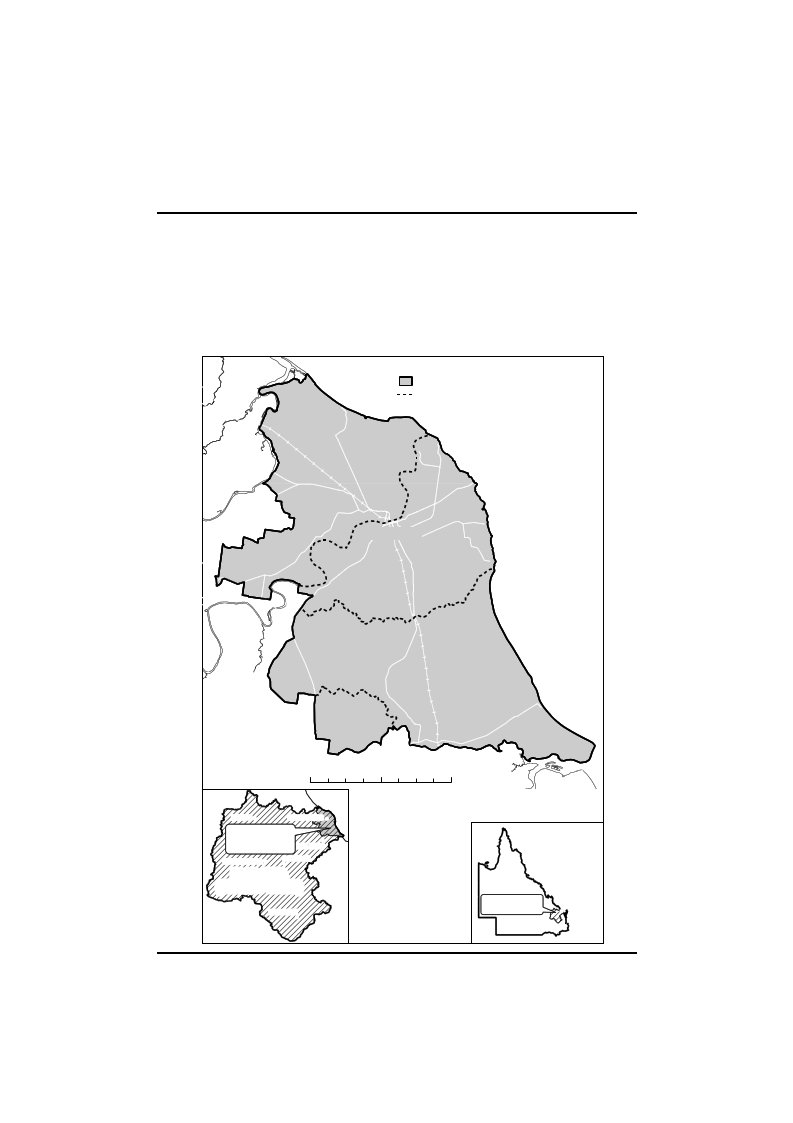
2000Schedule 1Schedule
1Plan area mapsection 4Page
42Current as at 28 May 2014
Schedule 2Water Resource
(Burnett Basin) Plan 2000Schedule 2Water project
areassection 16(1)1Barker–Barambah water project areaThe
Barker–Barambah water project area consists of—(a)thepartofBarambahCreekfromdownstreamofStonelands gauging station (AMTD 85.0km) to
AMTD189.5km, including the impounded areas of
all storagesin the part of the creek; and(b)thepartofBarkerCreekbetweentheconfluenceofBarker and Barambah Creeks and
Bjelke-Petersen Dam,includingtheimpoundedareaofthedam(AMTD0.0km to AMTD
38.2km).2Boyne River water project areaThe
Boyne River water project area consists of the part of theBoyneRiverbetweentheconfluenceoftheBoyneandBurnettriversandBoondoomaDam,includingtheimpoundedareaofthedam(AMTD0.0kmtoAMTD110.5km).3Bundaberg water project areaThe
Bundaberg water project area consists of—(a)the
part of the Kolan River between Kolan Barrage andFred
Haigh Dam, including the impounded area of thedamandBuccaWeir(AMTD14.7kmtoAMTD116.0km);
and(b)thepartoftheBurnettRiverbetweenBenAndersonBarrageandtheimpoundedareaoftheBurnettRiverDam,
including the impounded areas of the barrage andNedChurchwardWeir(AMTD25.9kmtoAMTD162.8km);
andCurrent as at 28 May 2014Page
43
Water Resource (Burnett Basin) Plan
2000Schedule 2(c)Sheepstation Creek between AMTD 0.0km and
AMTD8.6km; and(d)StAgnesCreekbetweenAMTD0.0kmandAMTD1.3km.4Three Moon Creek water project
areaThe Three Moon Creek water project area
consists of—(a)thepartofThreeMoonCreekbetweenAbercornandCania Dam, including the impounded area of
the dam(AMTD 13.2km to AMTD 130.8km); and(b)thepartofMonalCreekbetweenAMTD0.0kmandAMTD
2.8km.5Upper Burnett water project
areaThe Upper Burnett water project area
consists of—(a)thepartoftheBurnettRiverbetweentheimpoundedarea of the
Burnett River Dam and John Goleby Weir,including the
impounded areas of Claude Wharton Weir,Jones Weir,
Kirar Weir and John Goleby Weir (AMTD162.8km to AMTD
333.9km); and(b)the part of the Nogo River between the
confluence of theNogoandBurnettriversandWurumaDam,includingtheimpoundedareaofthedam(AMTD0.0kmtoAMTD 44.5km).Page 44Current as at 28 May 2014
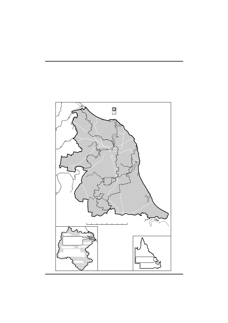
Schedule 3Water Resource
(Burnett Basin) Plan 2000Schedule 3Subcatchment
areassection 17(1)Current as at 28
May 2014Page 45
Water Resource (Burnett Basin) Plan
2000Schedule 4Schedule
4Nodessection 18Part
1Nodes for surface waterNode1234567891011121314151617LocationBurnett River at river mouth (AMTD
0.0km)Burnett River at Figtree gauging station
(AMTD 119km)Burnett River at Gayndah flume (AMTD
201.3km)Barambah Creek at Ban Ban (AMTD
35.1km)Barambah Creek at Stonelands (AMTD
90.3km)Boyne River at Derra (AMTD 6.4km)Stuart River at Proston Rifle Range (AMTD
24.1km)Auburn River at Glenwood (AMTD
37.9km)Burnett River at Eidsvold (AMTD
291.1km)Three Moon Creek at Abercorn (AMTD
13.1km)Kolan River at river mouth (AMTD
0.0km)Kolan River at Bucca Weir Tailwater (AMTD
37.9km)Elliott River at river mouth (AMTD
0.0km)Elliott River at Elliott gauging station
(AMTD 17.0km)Gregory River at river mouth (AMTD
0.0km)Gregory River at Burrum Highway (AMTD
47.9km)Isis River at river mouth (AMTD
0.0km)Page 46Current as at 28
May 2014
Node1819Water Resource (Burnett Basin) Plan
2000Schedule 4LocationIsis
River at Bruce Highway (AMTD 22.7km)Splinter Creek
at Dakiel (AMTD 74.8km)Part 2Nodes for
groundwaterTerrestrial vegetationNodeLocation20Tantitha-Whymere (site 1)21Tantitha-Whymere (site 2)22Pasturage Reserve (site 1)23Pasturage Reserve (site 2)24Moore Park (site 1)25Moore Park (site 2)26North Gregory-Isis Highway (site
1)27North Gregory-Isis Highway (site
2)28Meadowvale (site 1)29Meadowvale (site 2)30Foley (site 1)31Foley (site 2)Current as at 28
May 2014Page 47
Water Resource (Burnett Basin) Plan
2000Schedule 4Riparian
vegetationNodeLocation32Gregory River (site 1)33Gregory River (site 2)34Elliott River (site 1)35Elliott River (site 2)WetlandsNode36373839404142LocationTantitha-Whymere
(site 1)Tantitha-Whymere (site 2)Moore Park (site 1)Moore Park (site
2)Pasturage Reserve (site 2)Elliott Heads (site 1)Elliott Heads
(site 2)Page 48Current as at 28
May 2014
Water Resource (Burnett Basin) Plan
2000Schedule 4ASchedule
4ACoastal Burnett groundwatermanagement areasection
18ALEGEND!38MOORE24!39PARK25NORTHCOASTRIVERRAILWAY!29!2836!20!37!21NodeCoastal Burnett Groundwater Management
AreaBURNETTHEADS´22!!4203BARGARAPACIFICKOLANROADRIVERBUNDABERGGINGINBUNDABERGBURNETTELLIOTT!34RI!V3E5ROCEANELLIOTTHEADS41!!42ISISHIGHWAYNORTHCOASTRAILWAYRD.27!!2632!!31!30!330510GGOROEDGWOOROYDRIVER20KilometresWOODGATEBEACHMONTO!BUNDABERG!COASTALBURNETTGROUNDWATER!MANAGEMENTAREACHILDERSMUNDUBBERA!GAYNDAH!PLANAREA(BURNETTBASIN)KINGAROY!QUEENSLANDPLANAREA(BURNETTBASIN)BUNDABERG!!BRISBANECurrent as at 28
May 2014Page 49
Water Resource (Burnett Basin) Plan
2000Schedule 4BSchedule
4BGroundwater sub-areas forupper groundwater unitsection
18B(2)MOOREPARKLEGENDCoastal Burnett
Groundwater Management AreaGroundwater
Sub-area BoundariesNORTHCOASTRIVERRAILWAYKolan-BurnettBURNETTHEADS´BARGARAPACIFICROADGINGINRIVERBBUuNrDnABeEtRtG-E l
l i o t tBUNDABERBGURNETTELLIOTTRIVEROCEANELLIOTTHEADSKOLANISISHIGHWAYNORTHCOASTElliott-GregoryGGROEOGDOWROYODRAILWAYFarnsfield0510RD.RIVER20KilometresWOODGATEBEACHMONTO!BUNDABERG!COASTALBURNETTGROUNDWATER!MANAGEMENTAREACHILDERSMUNDUBBERA!GAYNDAH!PLANAREA(BURNETTBASIN)KINGAROY!Page
50QUEENSLANDPLANAREA(BURNETTBASIN)BUNDABERG!!BRISBANECurrent as at 28
May 2014
Schedule 4CWater Resource
(Burnett Basin) Plan 2000Schedule 4CGroundwater
sub-area forlower groundwater unitsection
18B(3)RIVERMOOREPARKLEGENDCoastal Burnett Groundwater Management
AreaGroundwater Sub-areaNORTHCOASTFairymeadRAILWAYBURNETTHEADS´BARGARAPACIFICROADRIVERBUNDABERGGINGINBUNDABERGBURNETTELLIOTTRIVEROCEANELLIOTTHEADSKOLANISISHIGHWAYNORTHCOASTGOOGDRWEOGOODRYRAILWAY0510MONTO!BUNDABERG!COASTALBURNETTGROUNDWATER!MANAGEMENTAREACHILDERSMUNDUBBERA!!GAYNDAHPLANAREA(BURNETTBASIN)KINGAROY!Current as at 28 May 2014RD.RIVER20KilometresWOODGATEBEACHQUEENSLANDPLANAREA(BURNETTBASIN)BUNDABERG!!BRISBANEPage
51
Water Resource (Burnett Basin) Plan
2000Schedule 5Schedule
5Environmental flow objectivessection 19Part 1Low
flow objectives1At each node mentioned in table 1,
column 1, the percentageof the total number of days in the
simulation period when thedaily flow is less than 2ML should be
between the minimumand maximum percentages stated for the
node.Table 1Column 1Node123456789101112131415Page 52Column 2Min–Max%2–182–202–262–202–202–342–3246–8210–4644–802–262–262–202–2624–60Current as at 28
May 2014
Column 116171819Water Resource (Burnett Basin) Plan
2000Schedule 5Column 232–682–386–4240–762At each node mentioned in table 2,
column 1, the 50% dailyflow exceedence stated for each month
for the node should beequalledorexceededbetween32%and68%ofthetotalnumber of days in the month in the
simulation period.Table 2Column 1Column 2Node50%
daily flow exceedence (ML/day)JanFebMarAprMayJunJulAugSeptOctNov
Dec11313 151911545833152802551541372123707892976110882840320820819510910114024462135205394081577275602522501093054185214211130778474495164691435126144126845963594545545910261241339233131412661528657232416966644671884124000000000978117102442623174351646101321000000011151878058532620116713587587311721812359550423242158135125825768100167134460625341383425212019231421333631222018141211101215244949231274100021692020742100001Current as at 28 May 2014Page
53
Water Resource (Burnett Basin) Plan
2000Schedule 5Column 1NodeJanFeb1722351818281903Column 250% daily flow
exceedence (ML/day)MarAprMayJunJulAugSeptOctNov
Dec3016977433512241376632241043122000003At each node
mentioned in table 3, column 1, the 90% dailyflow exceedence
stated for each month for the node should beequalledorexceededbetween72%and100%ofthetotalnumber of days in the month in the
simulation period.Table 3Column 1Column 2Node90%
daily flow exceedence (ML/day)JanFebMarAprMay
JunJulAug SeptOctNovDec117319116373493828231315281322921107628191716129111571318351641321001164231917111091076891151212151210997789106484211100012722311110001180000000000009000000000000100000000000001114575818652000021211404112553100131334910131211974321400344544321015000000000000Page 54Current as at 28 May 2014
Water Resource (Burnett Basin) Plan
2000Schedule 5Column 1Column 2Node90%
daily flow exceedence (ML/day)JanFebMarAprMay
JunJulAug SeptOctNovDec160000000000001724420000000018133100000000190000000000004At each node mentioned in table 4,
column 1—(a)lowflowexceedenceduration(10cmabovecease-to-flow)shouldbebetweentheminimumandmaximum percentages stated for the node in
column 2;and(b)lowflowexceedenceduration(30cmabovecease-to-flow)shouldbebetweentheminimumandmaximum percentages stated for the node in
column 3.Table 4Column 1Node23456789101416Column 2Min–Max%76–9864–9876–9876–9854–9066–9815–5148–8418–5470–9828–64Current as at 28
May 2014Column 3Min–Max%52–8835–7136–7232–6824–607–433–3922–582–312–372–31Page
55
Water Resource (Burnett Basin) Plan
2000Schedule 5Column 11819Column 250–8616–52Column 32–302–255At
each node mentioned in table 5, column 1—(a)the
number of periods of no flow of at least 1 month inthe
simulation period should be between the minimumand maximum
number stated for the node in column 2;and(b)the number of periods of no flow of at
least 3 months inthe simulation period should be between the
minimumand maximum number stated for the node in
column 3;and(c)the number of
periods of no flow of at least 6 months inthe simulation
period should be between the minimumand maximum
number stated for the node in column 4;and(d)the number of periods of no flow of at
least 9 months inthe simulation period should be between the
minimumand maximum number stated for the node in
column 5.Table 5Column 1NodeColumn 2Min–MaxColumn 3Min–MaxColumn 4Min–MaxColumn 5Min–Max10–20–00–00–020–50–20–00–0311–330–30–00–042–60–20–00–050–00–00–00–0625–722–60–00–0718–532–60–00–0Page 56Current as at 28 May 2014
Column 18910111219Column 2109–31550–145104–3009–258–23100–289Water Resource
(Burnett Basin) Plan 2000Schedule 5Column 326–753–97–200–00–338–109Column 48–240–20–20–00–315–45Column 54–120–00–00–00–06–18Part 2Medium to high flow objectives1.(1)At each node
mentioned in table 6, column 1—(a)the
annual proportional flow deviation (APFD)
must beless than the APFD stated for the node in
column 2; and(b)the mean annual flow, expressed as a
percentage of themeanannualflowforthepre-developmentflowsequence, must be at least the percentage
stated for thenode in column 3; and(c)the1.5yearaveragerecurrenceintervaldailyflowvolume (1.5 year
ARI), expressed as a percentage of the1.5yearARIforthepre-developmentflowsequence,mustbeatleastthepercentagestatedforthenodeincolumn 4; and(d)the
5 year average recurrence interval daily flow volume(5 year ARI), expressed as
a percentage of the 5 yearARI for the pre-development flow
sequence, must be atleast the percentage stated for the
node in column 5; and(e)the20yearaveragerecurrenceintervaldailyflowvolume (20 year
ARI), expressed as a percentage of the20yearARIforthepre-developmentflowsequence,mustbeatleastthepercentagestatedforthenodeincolumn 6.(2)Also, at each node mentioned in table 6,
column 1—Current as at 28 May 2014Page
57
Water Resource (Burnett Basin) Plan
2000Schedule 5(a)the
extent to which the APFD is more than 2 should beminimised; and(b)the
extent to which the mean annual flow expressed as apercentageofthemeanannualflowforthepre-development flow sequence is less
than 81% shouldbe minimised; and(c)theextenttowhichthe1.5yearARIexpressedasapercentage of the 1.5 year ARI for the
pre-developmentflowsequenceislessthan74%shouldbeminimised;and(d)theextenttowhichthe5yearARIexpressedasapercentage of the 5 year ARI for the
pre-developmentflowsequenceislessthan71%shouldbeminimised;and(e)theextenttowhichthe20yearARIexpressedasapercentage of the 20 year ARI for the
pre-developmentflow sequence is less than 82% should be
minimised.Table 6Column 1NodeColumn 2APFDColumn 3Meanannualflow%Column 41.5 yearARI%Column 5Column 65 year
ARI20 year ARI%%12.27252718222.18174718232.08171718242.07974718252.76251627162.96937526372.08169718280.1999910010092.381667182102.375665680Page 58Current as at 28
May 2014
Water Resource (Burnett Basin) Plan
2000Schedule 5Column 1Node111213141516171819Column 2APFDColumn 3Meanannualflow%Column 41.5 yearARI%2.076722.178671.185741.087850.496950.199990.298990.199992.08174Column 5Column 65 year
ARI20 year ARI%%7058696610010010010010010010010010010010010071822Theflowregimeclassateachnodemustbemaintainedas‘late summer’ flow regime class.3Ateachofthefollowingnodesthemeanwetseasonflow,expressed as a percentage of the mean wet
season flow for thepre-developmentflowsequence,mustbeatleastthepercentage stated for the node—(a)node 1—79%;(b)node
11—77%;(c)node 13—90%;(d)node
15—97%;(e)node 17—99%.Current as at 28
May 2014Page 59
Water Resource (Burnett Basin) Plan
2000Schedule 5Part 3Groundwater-dependentecosystem
objectives1Thesimulatedaveragecoastalsubmarinegroundwaterdischargeforagroundwatersub-areamentionedintable7,column 2, is at least the volume stated in
column 3 of the tablefor the groundwater sub-area.Table
7Column 1Groundwater
unitUpperUpperUpperLowerColumn 2Groundwater
sub-areaKolan-BurnettBurnett-ElliottElliott-GregoryFairymeadColumn 3Volume
(ML)86001800420038002At each node mentioned in table 8,
column 1—(a)minimisetheextenttowhichthesimulatedaveragedepth to the watertable is more than the
distance statedfor the node in column 2 of the table;
and(b)thesimulatedaveragedepthtothewatertableisnotmore than the distance stated for the
node in column 3of the table; and(c)minimise the extent to which the simulated
depth to thewatertable is more than the distance stated
for the nodein column 3 of the table in the simulation
period; and(d)any period, expressed as a percentage
of the simulationperiod for groundwater, for which the
simulated depth tothe watertable is more than the distance
stated for thenodeincolumn3ofthetableisnotmorethanthepercentage stated in column 4 of the table
for the node.Page 60Current as at 28
May 2014
Table
8Column 1Groundwaternode2021222324252627282930313233343536373839404142Column 2distance (m)2.949.108.193.692.494.5013.602.892.391.8915.8910.245.013.390.962.132.006.372.002.002.006.492.00Water Resource (Burnett Basin) Plan
2000Schedule 5Column 3Maximumdistance
(m)3.6910.859.944.443.245.7515.353.644.143.6417.6411.996.264.141.712.882.506.872.502.502.506.992.50Column 4Percentage ofsimulation
period1.000000000.330.502.50007.088.338.4208.5800002.830Current as at 28 May 2014Page
61
Water Resource (Burnett Basin) Plan
2000Schedule 6Schedule
6Water allocation securityobjectivessection 23Part
1Supplemented water1Forwaterallocationsinahighprioritygroupinawaterproject
area—(a)the supplemented water sharing index
must be at least95%; and(b)theextenttowhichthesupplementedwatersharingindex is less
than 100% should be minimised.2(1)Forwaterallocationsinamediumprioritygroupinthefollowing water project areas, the
supplemented water sharingindex for the allocations must be at
least the percentage statedfor the
area—(a)Barker–Barambah water project
area—85%;(b)Boyne River water project
area—73%;(c)Bundaberg water project
area—90%;(d)Upper Burnett water project
area—90%.(2)Also, for water allocations in a
medium priority group in thefollowingwaterprojectareas,theextenttowhichthesupplemented water sharing index for the
allocations is lessthan the percentage stated for the area
should be minimised—(a)Barker–Barambah
water project area—90%;(b)Boyne River
water project area—90%;(c)Bundaberg water
project area—95%;(d)Three Moon Creek water project
area—90%;(e)Upper Burnett water project
area—95%.Page 62Current as at 28
May 2014
Part
2Water Resource (Burnett Basin) Plan
2000Schedule 6Unsupplemented
water1For all water allocations for taking
unsupplemented water in asubcatchment area mentioned in table
1, column 1, the 30%unsupplemented water sharing index
must be more than—(a)forthegroupofallocationsconvertedfromauthorisationsthatstatedtheareasthatmaybeirrigated—the
percentage stated in table 1, column 2, forthe subcatchment
area; and(b)for the group of other allocations—the
percentage statedin table 1, column 3, for the subcatchment
area.Table 1Column 1Subcatchment areaABCDEFGHIJKLMNOColumn 2%111107113113116113104105111106107110107108106Current as at 28 May 2014Column 3%113108106127114110105131118114114111107111112Page
63
Water Resource (Burnett Basin) Plan
2000Schedule 6Column 1Subcatchment areaPQRSColumn 2%106117109106Column 3%1361181131122For all water
allocations for taking unsupplemented water in asubcatchment area mentioned in table 2,
column 1, the 50%unsupplemented water sharing index must be
more than—(a)forthegroupofallocationsconvertedfromauthorisationsthatstatedtheareasthatmaybeirrigated—the
percentage stated in table 2, column 2, forthe subcatchment
area; and(b)for the group of other allocations—the
percentage statedin table 2, column 3, for the subcatchment
area.Table 2Column 1Subcatchment areaABCDEFGHIJPage
64Column 2%94959696979697959697Column 3%96929592919197107106103Current as at 28 May 2014
Column 1Subcatchment
areaKLMNOPQRSWater Resource (Burnett Basin) Plan
2000Schedule 6Column 2%98989998979810110097Column 3%961019710210111094971013For all water allocations for taking
unsupplemented water in asubcatchment area mentioned in table
3, column 1, the 70%unsupplemented water sharing index
must be more than—(a)forthegroupofallocationsconvertedfromauthorisationsthatstatedtheareasthatmaybeirrigated—the
percentage stated in table 3, column 2, forthe subcatchment
area; and(b)for the group of other allocations—the
percentage statedin table 3, column 3, for the subcatchment
area.Table 3Column 1Subcatchment areaABCDECurrent as at 28 May 2014Column 2%7781827476Column 3%8274876280Page
65
Water Resource (Burnett Basin) Plan
2000Schedule 6Column 1Subcatchment areaFGHIJKLMNOPQRSColumn 2%8087898286887884898486828784Column 3%8186628083839185888946848589Part
3Groundwater in the CoastalBurnett groundwatermanagement
areaFor water allocations for taking groundwater
in a groundwatersub-area mentioned in table 4, column
1—(a)thesimulatednominalvolumeisnotmorethanthevolumestatedincolumn2ofthetableforthegroundwater
sub-area; andPage 66Current as at 28
May 2014
Water Resource (Burnett Basin) Plan
2000Schedule 6(b)the
simulated nominal volume probability is at least thepercentagestatedincolumn3ofthetableforthegroundwater
sub-area.Table 4Column 1Groundwater sub-areaColumn 2Simulated nominalvolumeKolan-Burnett20125Burnett-Elliott25139Elliott-Gregory4555Farnsfield1644Fairymead13362Column 3Simulated
nominalvolume probability—%5552565461Current as at 28 May 2014Page
67
Water Resource (Burnett Basin) Plan
2000Schedule 7Schedule
7Rates and pump sizessection
31(b)Pump size (mm)3240506580100125150200250300350375 to
400450500600 to
610660800Rate
(ML/day)0.691.052.24.05.68.210.012.919.025.930.035.043.255.065.886.4132184Page 68Current as at 28 May 2014
Schedule 8Column 1SubcatchmentABCDEFGHIJKLMNOPQRSWater Resource (Burnett Basin) Plan
2000Schedule 8Volumes for
simulated meanannual diversionssection 32(2) and
(3)Column 2ML3560113011200724037301230298035003490656052904001530905440192109060010Column 3ML9902002480229015309011809410730158052602150140268021301790900120010Current as at 28 May 2014Page
69
Water Resource (Burnett Basin) Plan
2000Schedule 9Schedule
9Dictionarysection 3Page
701.5yearaveragerecurrenceintervaldailyflowvolumemeans the daily
flow volumethat has a 67% probability ofbeing reached at least once a year.5
year average recurrence interval daily flow volumemeansthedailyflowvolumethathasa20%probabilityofbeingreached at least
once a year.20 year average recurrence interval daily
flow volumemeansthedailyflowvolumethathasa5%probabilityofbeingreached at least
once a year.30%unsupplementedwatersharingindex,foragroupofwaterallocationsfortakingunsupplementedwaterinasubcatchment
area, means—(a)forthegroupofallocationsinthesubcatchmentareaconverted from authorisations that stated
the areas thatmay be irrigated—the percentage of the
simulated meanannual diversion, for all those allocations,
calculated tooccur in at least 30% of years in the
simulation period;and(b)for the group of
other allocations in the subcatchmentarea—thepercentageofthesimulatedmeanannualdiversion, for
all those allocations, calculated to occur inat least 30% of
years in the simulation period.50% daily flow
exceedence, for a month, means the flow, inmegalitres, that is equalled or exceeded on
50% of days in themonth in the simulation period.50%unsupplementedwatersharingindex,foragroupofwaterallocationsfortakingunsupplementedwaterinasubcatchment
area, means—(a)forthegroupofallocationsinthesubcatchmentareaconverted from authorisations that stated
the areas thatmay be irrigated—the percentage of the
simulated meanCurrent as at 28 May 2014
Water Resource (Burnett Basin) Plan
2000Schedule 9annual
diversion, for all those allocations, calculated tooccur in at least 50% of years in the
simulation period;and(b)for the group of
other allocations in the subcatchmentarea—thepercentageofthesimulatedmeanannualdiversion, for
all those allocations, calculated to occur inat least 50% of
years in the simulation period.70%unsupplementedwatersharingindex,foragroupofwaterallocationsfortakingunsupplementedwaterinasubcatchment
area, means—(a)forthegroupofallocationsinthesubcatchmentareaconverted from authorisations that stated
the areas thatmay be irrigated—the percentage of the
simulated meanannual diversion, for all those allocations,
calculated tooccur in at least 70% of years in the
simulation period;and(b)for the group of
other allocations in the subcatchmentarea—thepercentageofthesimulatedmeanannualdiversion, for
all those allocations, calculated to occur inat least 70% of
years in the simulation period.90% daily flow
exceedence, for a month, means the flow, inmegalitres, that is equalled or exceeded on
90% of days in themonth in the simulation period.affected by seawater intrusionmeans the arithmetic mean ofelectricalconductivityatparticulardepthsinanaquiferismore than 2500µS/cm.AMTDmeans the
adopted middle thread distance which is thedistanceinkilometres,measuredalongthemiddleofawatercourse, that a specific point in
the watercourse is fromthewatercourse’smouthorjunctionwiththemainwatercourse.annualproportionalflowdeviationmeansthestatisticalmeasureofchangestoflowseasonandvolumeinthesimulationperiodcalculatedusingtheformulaforannualproportional
flow deviation described in Technical Report 5of ‘Fitzroy
Basin Water Allocation and Management PlanningTechnical
Reports’ published by the department.Current as at 28
May 2014Page 71
Water Resource (Burnett Basin) Plan
2000Schedule 9Page 72authorisationmeansalicence,permitorotherauthoritytotake water given under the Act or the
repealed Act, other thana permit for stock or domestic
purposes.Coastal Burnett groundwater management
areasee section18A.CoastalBurnettgroundwaterprojectnumericalgroundwaterflowmodelmeansthedepartment’scomputermodel developed using the code MODFLOW that
simulatesmovement of water below the surface of the
land.commencementmeans the
commencement of this plan.compensation flow objectivemeans an objective that may beexpressedasaperformanceindicatorfortheprovisionofwaterreleasesfromadamforstockordomesticpurposesdownstream of the dam.dewatering
purposesmeans—(a)draining,eitherpermanentlyortemporarily,overlandflow
water from land; or(b)removing groundwater from soils or
sediments that arewaterlogged.extension
area—1TheextensionareaisthepartoftheCoastalBurnettgroundwatermanagementareathat,atthecommencementofthisdefinition,isnotintheBundaberg subartesian area.2Foritem1,theBundabergsubartesianareaistheBundaberg
subartesian area on plan AP10062, declaredtobeasubartesianareaundertheWaterRegulation2002,section 102.fish habitat
areameans an area that is declared to be a
fishhabitat area under theFisheries Act
1994.flowregimeclassmeansthemeasureofflowregimeseasonalityworkedoutusingthemethodstatedinHaines,A.T.,Finlayson,B.L.andMcMahon,T.A.,‘Aglobalclassification
of river regimes. Applied Geography, 1988’.groundwatermeans
underground water.Current as at 28 May 2014
Water Resource (Burnett Basin) Plan
2000Schedule 9groundwater-dependentecosystemobjectivesseesection20A.groundwater-dependentecosystemsmeansecosystemsaffectedbythepermanentortemporarypresenceofgroundwater.groundwater
sub-areameans a groundwater sub-area undersection 18B(2) or (3).groundwater
unitsee section 18B(1).instructionalseawaterintrusionmodelmeansthedepartment’scomputermodeldevelopedusingthecodeMODHMS that
simulates movement of water and transfer ofdissolved salts
below the surface of the land.IQQM computer
programmeans the department’s IntegratedQuantityandQualityModellingcomputerprogram,andassociatedstatisticalanalysisandreportingprograms,thatsimulatedailystreamflows,flowmanagement,storages,releases,instreaminfrastructure,waterdiversions,waterdemands and other hydrologic events in the
plan area.licencemeans—(a)a water licence; or(b)a licence under theWater Resources Act 1989.lowergroundwaterunitmeansthelowergroundwaterunitunder section 18B(1)(b).low flow
exceedence duration (10cm above cease-to-flow)fora
watercourse, means the percentage of the total number ofdays
in the simulation period that the watercourse’s daily flowisatleast10cmabovethecease-to-flowlevelinthewatercourse.low flow
exceedence duration (30cm above cease-to-flow)fora
watercourse, means the percentage of the total number ofdays
in the simulation period that the watercourse’s daily flowisatleast30cmabovethecease-to-flowlevelinthewatercourse.Current as at 28
May 2014Page 73
Water Resource (Burnett Basin) Plan
2000Schedule 9Page 74meanannualflowmeansthetotalvolumeofflowinthesimulationperioddividedbythenumberofyearsinthesimulation period.mean wet season
flowmeans the total volume of flow duringthemonthsofJanuarytoMarchinthesimulationperioddivided by the number of years in the
simulation period.megalitremeans 1 million
litres.MLmeans megalitre.nodesee
section 18.permitmeans—(a)a water permit; or(b)a
permit under section 56 or 57 of theWater
ResourcesAct 1989.plan
areameans the area shown as the plan area on the
map inschedule 1.plan area
mapmeans the map in schedule 1.pre-developmentflowsequencemeansthestreamflowscalculatedusingtheIQQMcomputerprogramforthesimulation period as if—(a)there were no dams or other water
infrastructure in theplan area; and(b)no
water was taken under licences or permits in the planarea.resource
operations planmeans the resource operations planto
implement this plan.seawater intrusionmeans movement
of sea water inland intoaquifers that contain
freshwater.seawater intrusion objectivesee
section 20C.simulated average area affected by seawater
intrusionmeanstheareaaffectedbyseawaterintrusionsimulatedbytheinstructionalseawaterintrusionmodelforthesimulationperiod for
groundwater divided by the number of months inthe simulation
period.Current as at 28 May 2014
Water Resource (Burnett Basin) Plan
2000Schedule 9simulatedaveragecoastalsubmarinegroundwaterdischargemeans the total simulated groundwater
discharge tothe coast in the simulation period for
groundwater divided bythe number of months in the simulation
period.simulated average depth to the
watertablemeans the sum ofthe simulated
vertical distances from the surface of the land tothewatertableinthesimulationperiodforgroundwaterdivided by the
number of months in the simulation period.simulateddepthtothewatertablemeansthesimulatedvertical
distance from the surface of the land to the watertable.simulated mean annual diversion,
for authorisations to takewater in a subcatchment area, means
the total volume of watertaken in the subcatchment area under
the authorisations in thesimulationperioddividedbythenumberofyearsinthesimulation period.simulatednominalvolume,forwaterallocationstotakegroundwaterinagroundwatersub-area,meansthetotalvolumeofwatertakenunderthewaterallocationsinthegroundwatersub-areainthesimulationperiodforgroundwater,calculatedmonthly,dividedbythenumberofyears in the simulation period.simulated nominal volume probability,
for water allocationstotakegroundwaterinagroundwatersub-area,meansthepercentage of the number of years in the
simulation period forgroundwater,calculatedforthewaterallocationsinthegroundwater sub-area, in which the
nominal volumes for thewater allocations are simulated to be
fully supplied.simulation periodmeans the
period—(a)for surface water—from 1 July 1890 to
30 June 1997; or(b)for groundwater—from 1 January 1905 to
31 December2004.subcatchment
areasee section 17(1).submarine
groundwater dischargemeans the flow of wateron
continental margins from the sea bed to the ocean at thecoast.Current as at 28
May 2014Page 75
Water Resource (Burnett Basin) Plan
2000Schedule 9Page 76submarinegroundwaterdischargesystemmeansacoastaloceanecosystem,including,forexample,estuarinesystemsandseagrasscommunities,thatdependsonsubmarinegroundwater
discharge from terrestrial freshwater.supplemented
watermeans surface water supplied under aninterimresourceoperationslicence,resourceoperationslicence or other
authority to operate infrastructure.supplemented
water sharing index, for water allocations in aparticularprioritygroupinawaterprojectarea,meansthemedianofthepercentagesofthenumberofmonthsinthesimulation period, calculated for each
water allocation in theprioritygroupinthearea,inwhichtheallocationsaresimulated to be fully supplied.surface watersee section
5(1).unsupplementedwatermeanssurfacewaterthatisnotsupplemented
water.uppergroundwaterunitmeanstheuppergroundwaterunitunder section 18B(1)(a).waterholemeans a part of a watercourse that contains
waterafterthewatercourseceasestoflow,otherthanapartofawatercourse that is within the storage
area of a dam on thewatercourse.water
infrastructure operatormeans the holder of—(a)an interim resource operations
licence; or(b)a resource operations licence;
or(c)another authority to operate water
infrastructure for themanagement of water in a water project
area.water project areasee section
16(1).works replacing worksmeans works
that, in relation to theworksbeingreplaced,areareplacementborewithinthemeaningoftheCodeforSelf-assessableDevelopmentofReplacement Bores.Editor’s
note—A copy of the code is available on the
department’s website.Current as at 28 May 2014
EndnotesWater Resource
(Burnett Basin) Plan 2000Endnotes1Index to endnotesPage2Key . . . . . . . . . . . . . . . . .
. . . . . . . . . . . . . . . . . . . . . . . . . . . . . . . . . .
. . . . . . . . . . .773Table of reprints
. . . . . . . . . . . . . . . . . . . . . . . . . . . . . . . . . .
. . . . . . . . . . . . . . . . . .774List of legislation . . . . . . . . .
. . . . . . . . . . . . . . . . . . . . . . . . . . . . . . . . . .
. . . . . . . .785List of
annotations . . . . . . . . . . . . . . . . . . . . . . . . . . . .
. . . . . . . . . . . . . . . . . . . . . .792KeyKey to
abbreviations in list of legislation and annotationsKeyAIAamdamdtchdefdivexpgazhdginslapnotfdnumo in
comorigpparaprecpresprevExplanation=Acts
Interpretation Act 1954=amended=amendment=chapter=definition=division=expires/expired=gazette=heading=inserted=lapsed=notified=numbered=order in council=omitted=original=page=paragraph=preceding=present=previousKey(prev)procprovptpubdR[X]RArelocrenumrep(retro)rvsschsdivSIASIRSLsubunnumExplanation=previously=proclamation=provision=part=published=Reprint No. [X]=Reprints Act 1992=relocated=renumbered=repealed=retrospectively=revised version=section=schedule=subdivision=Statutory Instruments Act 1992=Statutory Instruments Regulation
2012=subordinate legislation=substituted=unnumbered3Table of reprintsA new reprint of
the legislation is prepared by the Office of the Queensland
ParliamentaryCounsel each time a change to the
legislation takes effect.The notes column for this reprint
gives details of any discretionary editorial powers undertheReprints Act 1992used by the
Office of the Queensland Parliamentary Counsel inpreparing it. Section 5(c) and (d) of the
Act are not mentioned as they contain mandatoryCurrent as at 28
May 2014Page 77
Water Resource (Burnett Basin) Plan
2000Endnotesrequirementsthatallamendmentsbeincludedandallnecessaryconsequentialamendments be
incorporated, whether of punctuation, numbering or another kind.
Furtherdetails of the use of any discretionary
editorial power noted in the table can be obtained bycontacting the Office of the Queensland
Parliamentary Counsel by telephone on 30039601 or email
legislation.queries@oqpc.qld.gov.au.From29January2013,allQueenslandreprintsaredatedandauthorisedbytheParliamentary Counsel. The previous
numbering system and distinctions between printedand
electronic reprints is not continued with the relevant details for
historical reprintsincluded in this table.ReprintNo.11AAmendments tonone2001
Act No. 32 (amd2001 Act No. 101)Effective15
December 20007 June 2001Reprint
date15 January 200111 January
2002ReprintNo.1B
rv1C rv1D22A2BAmendments included2005 SL No.
2642006 SL No. 492007 SL No.
298—2009 SL No. 2802011 Act No.
40Effective4 November
200531 March 200630 November
200730 November 200718 December
200924 November 2011NotesR1D
withdrawn, see R2Current as at28 May
2014Amendments included2014 Act No.
29Notes4List
of legislationRegulatory impact statementsFor
subordinate legislation that has a regulatory impact statement,
specific reference to the statementis included in
this list.Explanatory notesAll subordinate
legislation made on or after 1 January 2011 has an explanatory
note. For subordinatelegislation made before 1 January 2011
that has an explanatory note, specific reference to the note
isincluded in this list.Water Resource
(Burnett Basin) Plan 2000 SL No. 359approved by the
Governor in Council on 14 December 2000notfd gaz 15
December 2000 pp 1478–83commenced on date of
notificationexp 31 August 2014 (see 2000 Act No. 34 s
52A(3))amending legislation—Page 78Current as at 28 May 2014
Water Resource (Burnett Basin) Plan
2000EndnotesWater
Infrastructure Development (Burnett Basin) Act 2001 No. 32 (this
Act isamended, see amending legislation
below)date of assent 19 December 2001commenced on date of assentamending legislation—Water
Infrastructure Development (Burnett Basin) Amendment Act
2001No. 101 (amends 2001 No. 32 above)date
of assent 19 December 2001commenced on date of assentWater Resource (Burnett Basin) Amendment
Plan (No. 1) 2005 SL No. 264notfd gaz 4
November 2005 pp 869–70commenced on date of
notificationNote—An explanatory note was preparedWater Resource (Great Artesian Basin) Plan
2006 SL No. 49 s 1, pt 7 div 2notfd gaz 31
March 2006 pp 1282–5commenced on date of notificationNote—An explanatory note was preparedWater Resource (Burnett Basin) Amendment
Plan (No. 1) 2007 SL No. 298notfd gaz 30
November 2007 pp 1824–6commenced on date of
notificationNote—An explanatory note was preparedSustainable Planning Regulation 2009 SL No.
280 ss 1–2, pt 9 div 34notfd gaz 27 November 2009 pp
1001–6ss 1–2 commenced on date of
notificationremaining provisions commenced 18 December
2009 (see s 2)Water and Other Legislation Amendment Act
2011 No. 40 pt 1, s 107 schdate of assent 24 November 2011commenced on date of assentLand
and Other Legislation Amendment Act 2014 No. 29 s 1, pt 12 div
4date of assent 28 May 2014commenced on date of assent5List of annotationsWater to which plan appliess
5sub 2006 SL No. 49 s 46amd 2007 SL No.
298 s 3General outcomess 6amd
2005 SL No. 264 s 4; 2007 SL No. 298 s 4Ecological
outcomes for plan areas 7amd 2007 SL No.
298 s 5Current as at 28 May 2014Page
79
Water Resource (Burnett Basin) Plan
2000EndnotesBurnett River
basin and Burnett Rivers 11amd 2001 No. 32 s
10B (as ins 2001 No. 101 s 4)Coastal Burnett
groundwater management areas 13Ains
2007 SL No. 298 s 6Subdivision 1—Assessing consistency with
objectivessdiv 1 (ss 14–15)sub 2007 SL No.
298 s 7Nodess 18amd
2007 SL No. 298 s 8Subdivision 3—Groundwater units and
groundwater sub-areas for Coastal Burnettgroundwater
management areasdiv 3 (ss 18A–18C)ins 2007 SL No.
298 s 9Subdivision 1—Surface watersdiv
hdgins 2007 SL No. 298 s 10Objectivess 19amd
2007 SL No. 298 s 11Performance indicatorss
20amd 2007 SL No. 298 s 12Subdivision
2—Groundwatersdiv 2 (ss 20A–20D)ins 2007 SL No.
298 s 13Objectivess 23amd
2005 SL No. 264 ss 3, 4; 2007 SL No. 298 s 14Performance
indicatorss 24amd 2005 SL No. 264 ss 3, 4; 2007 SL
No. 298 s 15Division 1—General strategies for achieving
outcomesdiv hdgins 2007 SL No.
298 s 16Decisions about managing or allocating
waters 25amd 2007 SL No. 298 s 17Matters chief executive must considers
26amd 2005 SL No. 264 s 4; 2007 SL No. 298 s
18Division 2—Strategies for achieving outcomes
(surface water)div hdgins 2007 SL No.
298 s 19Division 3—Strategies for achieving outcomes
(groundwater)div hdgins 2007 SL No.
298 s 20DecisionnottoincreaseamountofgroundwatertakeninCoastalBurnettgroundwater management areas
30Ains 2007 SL No. 298 s 20Restriction on
taking or interfering with groundwaters 30Bins
2007 SL No. 298 s 20Page 80Current as at 28
May 2014
Water Resource (Burnett Basin) Plan
2000EndnotesTaking or
interfering with groundwater, other than for stock or domestic
purposes,using existing works in extension
areas 30Cins 2007 SL No.
298 s 20Taking groundwater for stock or domestic
purposes using existing workss 30Dins
2007 SL No. 298 s 20Restriction on taking groundwater for
stock or domestic purposes using new workss 30Eins
2007 SL No. 298 s 20Relationship with Sustainable Planning
Act 2009prov hdgamd 2009 SL No.
280 s 160(1)s 30Fins 2007 SL No.
298 s 20amd 2009 SL No. 280 s 160(2)–(3); 2011 Act
No. 40 s 107 sch; 2014 Act No.29 s 146Division 4—Authorisations and water
allocationsdiv hdgins 2007 SL No.
298 s 21Subdivision 1—Surface watersdiv
hdgins 2007 SL No. 298 s 21Maximum daily
rates for taking surface waterprov hdgamd
2007 SL No. 298 s 22(1)s 31amd 2007 SL No.
298 s 22(2)Annual volumes of surface water that may be
takenprov hdgamd 2007 SL No.
298 s 23(1)s 32amd 2005 SL No. 264 s 3; 2007 SL No.
298 s 23(2)Authorisation to take surface water
converted to water allocationprov hdgsub
2007 SL No. 298 s 24(1)s 34amd 2005 SL No.
264 s 3; 2007 SL No. 298 s 24(2)Subdivision
2—Groundwatersdiv 2 (ss 34A–34C)ins 2007 SL No.
298 s 25Division 5—Miscellaneousdiv hdgins
2007 SL No. 298 s 26Unallocated water in plan areas
37amd 2007 SL No. 298 s 27Continued effect
of moratorium notice—Act, s 46(3)s 37Ains
2007 SL No. 298 s 28Division 6—Implementing this
plandiv hdgins 2007 SL No.
298 s 29Amending resource operations plans
39Ains 2007 SL No. 298 s 30Division
1—Surface waterdiv hdgins 2007 SL No.
298 s 31Current as at 28 May 2014Page
81
Water Resource (Burnett Basin) Plan
2000EndnotesMonitoring for
surface waterprov hdgsub 2007 SL No.
298 s 32(1)s 40amd 2007 SL No. 298 s 32(2)Division 2—Groundwaterdiv 2 (s
42A)ins 2007 SL No. 298 s 33Minor amendment
of plan—Act, s 57s 44amd 2007 SL No. 298 s 34SCHEDULE 2—WATER PROJECT AREASBarker–Barambah water project areas
1amd 2005 SL No. 264 s 5(1)Boyne River water project areas
2amd 2005 SL No. 264 s 5(2)Bundaberg water project areas
3amd 2005 SL No. 264 s 5(3)–(4)Three Moon Creek water project areas
4amd 2005 SL No. 264 s 5(5)Upper Burnett water project areas
5amd 2005 SL No. 264 s 5(6)–(7)SCHEDULE 4—NODESsch hdgsub
2007 SL No. 298 s 35(1)sch 4amd 2007 SL No.
298 s 35(2)SCHEDULE4A—COASTALBURNETTGROUNDWATERMANAGEMENTAREAins
2007 SL No. 298 s 36SCHEDULE 4B—GROUNDWATER SUB-AREAS FOR
UPPER GROUNDWATERUNITins 2007 SL No. 298 s 36SCHEDULE 4C—GROUNDWATER SUB-AREA FOR LOWER
GROUNDWATERUNITins 2007 SL No. 298 s 36SCHEDULE 5—ENVIRONMENTAL FLOW
OBJECTIVESamd 2001 No. 32 s 10C (as ins 2001 No. 101 s
4); 2007 SL No. 298 s 37SCHEDULE 6—WATER ALLOCATION SECURITY
OBJECTIVESamd 2005 SL No. 264 ss 3, 4; 2007 SL No. 298
s 38SCHEDULE 7—RATES AND PUMP SIZESamd
2005 SL No. 264 s 6SCHEDULE 8—VOLUMES FOR SIMULATED MEAN ANNUAL
DIVERSIONSamd 2007 SL No. 298 s 39Page 82Current as at 28 May 2014