QueenslandMarineParksAct1982MARINEPARKS(CAIRNS)ZONINGPLAN1992Reprinted as in
force on 3 February 2000(includes amendments up to SL No. 295
of 1999)Reprint No. 1This reprint is
prepared bythe Office of the Queensland Parliamentary
CounselWarning—This reprint is not an authorised
copyNOTFURTHERAMENDEDLASTREPRINTBEFOREREPEALSee2004SLNo.238s29
Information about this reprintThis
plan is reprinted as at 3 February 2000.The
reprint—•showsthelawasamendedbyallamendmentsthatcommencedonorbeforethat day
(Reprints Act 1992 s 5(c))•incorporatesallnecessaryconsequentialamendments,whetherofpunctuation,numbering or
another kind (Reprints Act 1992 s 5(d)).Thereprintincludesareferencetothelawbywhicheachamendmentwasmade—see list of legislation and list of
annotations in endnotes.MinoreditorialchangesallowedundertheprovisionsoftheReprintsAct1992mentioned in the following list have
also been made to—•use standard punctuation consistent
with current drafting practice (s 27)•reorder definitions and other provisions
consistent with current drafting practice(s 30)•use aspects of format and printing
style consistent with current drafting practice(s 35).Also
see endnotes for information about when provisions
commenced.
s15s2Marine Parks (Cairns) Zoning Plan 1992MARINE PARKS (CAIRNS) ZONING PLAN1992[as amended by all amendments that
commenced on or before 3 February 2000]†PART
1—PRELIMINARY˙Short title1.This
zoning plan may be cited as theMarineParks(Cairns)ZoningPlan 1992.˙Application of
zoning plan1A.This zoning plan applies to the Cairns
Marine Park.Interpretation2.(1)In
this zoning plan—“animal”means any member
of the animal kingdom (other than human),(whether alive or
dead), and includes—(a)spat, spawn, eggs and parts of eggs;
and(b)the skin, feathers, shell or any other
part of an animal.“Authority”means the Great
Barrier Reef Marine Park Authority.“baitgathering”meansthetakingofyabbies,eugaries(pippies),baitworms
or crabs when taken by hand or by hand-held implement underfisheries legislation.“bait
netting”means fishing using a recreational bait net
or a commercialbait net described in, and used under
fisheries legislation.“bait worms”means worms
belonging to the Class Polychaeta of FamilyNereidae or
Family Eunicidae, that are taken for use as bait.
s26s2Marine Parks (Cairns) Zoning Plan 1992“Cairns Section”means the area
declared to be part of the Great BarrierReef Marine Park
and assigned the name ‘Great Barrier Reef MarinePark—CairnsSection’byproclamationundersection31(1)oftheGreatBarrierReefMarineParkAct1975oftheCommonwealth,published in the
Commonwealth of Australia Gazette on 13 September1989.“Cairns Section
Zoning Plan”means the zoning plan of the Great
BarrierReef Marine Park—Cairns Section.“collecting”meansthetakingofanyanimal,plantormarineproductdeclared by regulations made under
theGreatBarrierReefMarinePark
Act 1975of the Commonwealth for the purposes of the
CairnsSection Zoning Plan.“commercial
netting”means fishing using any net described in,
and usedunder fisheries legislation.“crabbing”means the taking
of crabs by the apparatus described in, andused under
fisheries legislation.“crabs”means crustaceans
of the Infraorder Brachyura.“educational
program”means the provision of transport,
accommodationor services for a group or groups of 6 or
more people (none of whomisatourist)principallyforthepurposeofsystematicallyeducatingthose
people.“eugarie”means a mollusc
belonging to the speciesPlebidonax deltoides.“facility”includes a
building, a structure, a vessel, goods, equipment andservices.“fisheries
legislation”meanstheFisheriesAct1976andtheFishingIndustry
Organisation and Marketing Act 1982.1“fishing”means the taking
of fish, crustaceans, echinoderms or molluscsdeclared by the
regulations made under theGreat Barrier Reef MarinePark
Act 1975of the Commonwealth for the purposes of the
CairnsSection Zoning Plan.1Now
seeFisheries Act 1994.
s27s2Marine Parks (Cairns) Zoning Plan 1992“Great
Barrier Reef Marine Park Authority”means the Great
BarrierReefMarineParkAuthorityestablishedbytheGreatBarrierReefMarine Park Act
1975of the Commonwealth.“highest
astronomical tide”means the highest level of the tides that
can bepredicted to occur under average
meteorological conditions and underany combination
of astronomical conditions.“high water”means the mean
height of the higher tide at spring tides.“hook”means
a single hook or a group of hooks linked (ganged) together.“limitedcollecting”means collecting
of shells, fish and invertebrates (otherthancoral—ClassAnthozoa)underthelimitationsdeclaredbytheregulations made
under theGreat Barrier Reef Marine Park Act
1975of the Commonwealth for the purposes of the
Cairns Section ZoningPlan.“limited
educational program”means an educational program that—(a)does not involve the taking of plants,
animals, or marine products;and(b)is a component of a course conducted
by—(i)a school or tertiary institution
accredited by a relevant Stateor Commonwealth
Department responsible for education; or(ii)anoverseaseducationinstitutionaccreditedbyarelevantnational body responsible for
education.“limited research”means research
that does not involve an activity that, ifit were not part
of a research activity, would require a permit in thezone—(a)under
the Zoning Plan; or(b)under the regulations made under
theGreat Barrier Reef MarinePark
Act 1975of the Commonwealth; or(c)under
the regulations.“Marine Park”means the Cairns
Marine Park.“median line”means the line
every point of which is equidistant from thenearest points of
the reefs or coastline to which it applies.
s28s2Marine Parks (Cairns) Zoning Plan 1992“minorworks”means
the installation of piles, moorings, public jetties,interpretive facilities and similar
installations that involve only minordisturbance to
the substrate or benthic communities, or alienation ofareas
of the marine park from enjoyment by the public.“oyster”means a mollusc
of the Family Ostreidae and includes an oysterwithout its
shell.“oyster gathering”meansthetakingofoystersfromanoystergroundunder
fisheries legislation.“oyster ground”means an oyster
ground under fisheries legislation.“permanentlymoored”,inrelationtoafacility,meansmooredin1 vicinity for the period of time
prescribed by the regulations made fortheCairnsSectionundertheGreatBarrierReefMarineParkAct1975oftheCommonwealth,but,ifaperiodoftimehasnotbeenprescribed, then,
for—(a)more than 14 consecutive days;
or(b)more than 30 days in any period of 60
days.“photography and filming”means the use of
still, video or cine cameraequipment for the recording of
images.“reef”includes bommie
fields, reef slopes, moats and ramparts.“reef edge”means
the seaward edge of a reef.“ship”means a vessel
with a gross tonnage in excess of 1 500 t.“spearfishing”means fishing,
using a spear or spear gun, but not using—(a)a
power-head; or(b)a firearm; or(c)underwater breathing apparatus other than a
snorkel.“stowed or secured”, in relation to
equipment, means rendered inoperativeand, in relation
to trawl equipment, rendered inoperative at least to theextent of having nets out of water and hung
on board with cod endsopen.“the 1 km
line”means the line every point of which is 1 km
seaward fromthe nearest point of the reef edge of the
reef to which it applies.“the 2 km line”has a
corresponding meaning to the 1 km line.
s29s2Marine Parks (Cairns) Zoning Plan 1992“the 5
km line”means the line every point of which is 5 km
seaward fromthe nearest point of the coastline of the
mainland at low water.“the 100 m line”has a
corresponding meaning to the 1 km line.“the 500 m
line”has a corresponding meaning to the 1 km
line.“thecoastal1kmline”meansthelineeverypointofwhichis1kmseaward
from—(a)the nearest point of the coastline at
low water of the island or themainland, to
which it applies; or(b)where there is a fringing reef wholly
or partly around the island oralong the
mainland to which it applies—the nearest point of thereef
edge of that fringing reef.“the coastal 100 m line”has a
corresponding meaning to the coastal 1 kmline.“the
coastal 200 m line”has a corresponding meaning to the coastal 1
kmline.“the coastal 500 m
line”has a corresponding meaning to the coastal 1
kmline.“tourist”meansapersonwhoisintheMarineParkprincipallyforthepurpose of recreation (that may
include fishing or collecting).“tourist
facility”means a facility that is provided for
tourists.“touristprogram”meansanactivitythatincludestheprovisionoftransport, accommodation or services for
tourists.“traditional fishing”means fishing,
other than for recreation, sale or tradepurposes, by a
traditional inhabitant.“traditionalhuntingandgathering”meanscollecting,otherthanforrecreation, sale
or trade purposes, by a traditional inhabitant.“traditionalinhabitant”meansapersonofAboriginalorTorresStraitIslander descent who is recognised in the
community and identifies asan Aboriginal or Torres Strait
Islander.“trolling”meansfishingwithaline,trailedbehindavesselthatisunderway but does not include
driftfishing when the vessel is adrift.
s
310s 3Marine Parks
(Cairns) Zoning Plan 1992“vessel”means a ship,
boat, hovercraft, raft, pontoon or any other thingcapable of carrying people or goods through
or on water.“works”meansactivitiesthatmightdisturb,removeordestroythesubstrate and associated benthic communities
(including vegetation)and includes the dumping of spoil,
harbour works, reclamation works,beachprotectionworks,excavation,filling,erectionofwalls,anddredging.“yabbies”meanscrustaceansofthegeneraUpogebiaandCallianassabelonging to the
Family Callianassidae.(2)In this zoning
plan—(a)a reference to a reef, for example
unnamed reef (reef 15–034), istaken to be a
reference to a reef depicted and numbered on theGreat
Barrier Reef Series 1:250 000 map sheets; and(b)allcoordinatesgivenareexpressedintermsofAustralianGeodetic Datum
1966 (AGD 66); and(c)if a part of a boundary of a zone, or
designated area, is describedby reference to a
line every point of which is a particular distanceseaward from the nearest point of the reef
or coastline to which itapplies, and that boundary intersects
another reef, coastline, zoneboundary,ordesignatedareaboundary,then,intheareaofoverlap, the boundary is the median
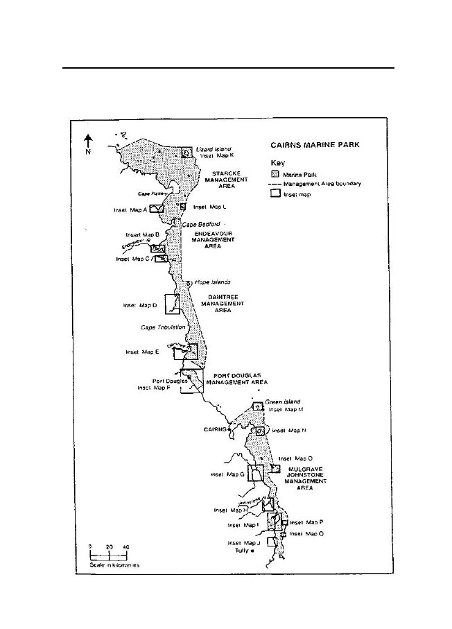
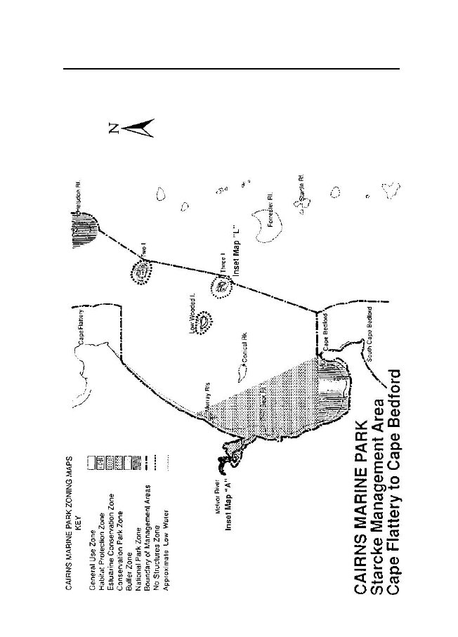
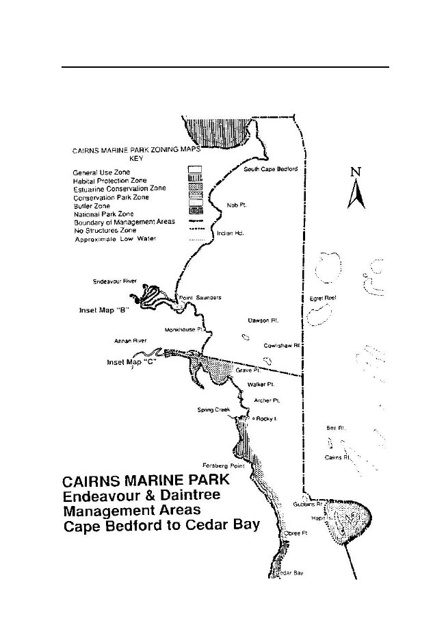
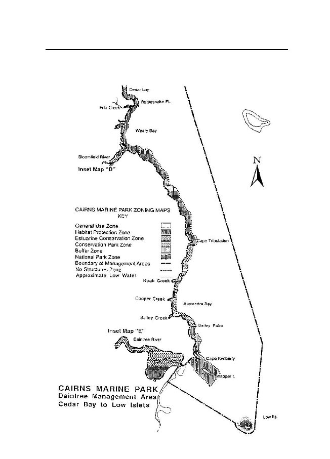
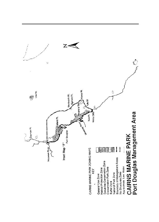
line.†PART 2—MANAGEMENT AREASManagement Areas3.(1)The
Marine Park consists of the following management areas—(a)Starcke Management Area;(b)Endeavour Management Area;(c)Daintree Management Area;(d)Port Douglas Management
Area;
s
411s 5Marine Parks
(Cairns) Zoning Plan 1992(e)Mulgrave-Johnstone Management Area;(f)Outer Islands Management Area.(2)The boundaries of the management areas
are set out in schedule 1.(3)The locations of
the management areas are shown on the maps inschedule 5.†PART 3—ZONING PROVISIONS†Division 1—ZonesZones4.(1)The Marine Park
consists of the following zones—(a)General Use Zone;(b)Habitat Protection Zone;(c)Estuarine Conservation Zone;(d)Conservation Park Zone;(e)Buffer Zone;(f)National Park Zone;(g)No
Structures Zone.(2)The boundaries of the zones are set
out in schedule 2.(3)Theapproximatelocationsofthezonesareshownonthezoningmaps in schedule
5.†Division 2—General Use ZoneObjective5.TheobjectiveoftheGeneralUseZoneistoprovidefortheconservationoftheMarinePark,whileprovidingopportunitiesforreasonable general use.
s
612s 9Marine Parks
(Cairns) Zoning Plan 1992Entry and use6.(1)Subject to clauses 17 and 18, part 4
(Designated area provisions)and part 5
(Additional uses and exemptions), a person may enter or use
theGeneralUseZoneforthepurposessetoutinclause6.3oftheCairnsSection Zoning
Plan.(2)ThedirectormaygivepermissionundertheMarineParksRegulation 1990for a person to
enter or use the General Use Zone for thepurposes set out
in clause 6.4 of the Cairns Section Zoning Plan.†Division 3—Habitat Protection
ZoneObjectives7.The
objectives of the Habitat Protection Zone are—(a)the
provide for the conservation of the Marine Park through theprotectionandmanagementofsignificanthabitatsfreefromtrawling and
generally free from shipping; and(b)to
provide for general use, including fishing and collecting.Entry
and use8.(1)Subject to
clauses 17 and 18, part 4 (Designated area provisions)and
part 5 (Additional uses and exemptions), a person may enter or use
theHabitat Protection Zone for the purposes set
out in clause 7.3 of the CairnsSection Zoning
Plan.(2)ThedirectormaygivepermissionundertheMarineParksRegulation 1990for a person to
enter or use the Habitat Protection Zone forthe purposes set
out in clause 7.4 of the Cairns Section Zoning Plan.†Division 4—Estuarine Conservation
ZoneObjectives9.The
objectives of the Estuarine Conservation Zone are—
s
1013s 10Marine Parks
(Cairns) Zoning Plan 1992(a)toprovidefortheprotectionofareasoftheMarineParkinanatural state
while allowing the public to appreciate and enjoy therelatively undisturbed nature of those
areas; and(b)to maintain fisheries production and
use; and(c)toprovidefortraditionalfishingandtraditionalhuntingandgathering.Entry and
use10.(1)Subject to
clauses 17 and 18, part 4 (Designated area provisions)and
part 5 (Additional uses and exemptions), a person may enter or use
theEstuarine Conservation Zone for any of the
following purposes—(a)recreationalactivitiesthatdonotinvolvethetakingofplants,animals, or
marine products;(b)fishing involving—(i)trolling; or(ii)line
fishing using no more than 6 hooks per line; or(iii)spearfishing; or(iv)bait
netting; or(v)commercial netting;(c)collecting involving—(i)limited collecting of shells, fish and
invertebrates (not coral);or(ii)oyster gathering; or(iii)crabbing; or(iv)bait
gathering;(d)photography, filming or sound
recording;(e)limited research;(f)conduct of a limited educational
program;(g)navigation of aircraft or vessels,
other than ships, if equipmentused for fishing
or collecting is stowed or secured at all times
s
1014s 10Marine Parks
(Cairns) Zoning Plan 1992when the aircraft or vessel is in a
part of the Zone in which theuse of that
equipment is not permitted under the Zoning Plan.(2)ThedirectormaygivepermissionundertheMarineParksRegulation 1990for a person to
enter or use the Estuarine ConservationZone for any of
the following purposes—(a)traditional
fishing and traditional hunting and gathering (other thanfishing or collecting specified in subclause
(1));(b)camping;(c)conduct of a tourist program;(d)mariculture;(e)research other than limited research;(f)conductofaneducationalprogramotherthanalimitededucational
program;(g)the operation of a vessel or aircraft
in 1 vicinity—(i)for more than 14 consecutive days;
or(ii)for more than 30 days in any period of
60 days;(h)the navigation of a hovercraft;(i)the navigation of ships for the
purpose of tourism or research;(j)the
operation of a facility for a purpose not listed in subclause
(1),consistent with the objective of the zone
including—(i)the discharge of wastes from the
facility;(ii)the building, assembling, fixing in
position, maintenance ordemolition of the facility;(iii)theconstruction,orconduct,ofmooringfacilitiesforvessels;(iv)the
operation of a landing area, or facility for aircraft;(k)the carrying out of minor
works;(l)within a designated Works Management
Area, the carrying out ofworks for a purpose consistent with
the objectives of the zone;(m)programs for the
taking of animals or plants that pose a threat
s
1115s 12Marine Parks
(Cairns) Zoning Plan 1992to—(i)human
life or safety; or(ii)marine or island ecosystems that are
part of the Marine Park;or(iii)the
use and amenity of an area or adjacent areas;(n)any
purpose not listed in the clause, consistent with the
objectivesof the zone.†Division 5—Conservation Park ZoneObjectives11.The
objectives of the Conservation Park Zone are—(a)toprovidefortheprotectionofareasoftheMarineParkinanatural state
while allowing the public to appreciate and enjoy therelatively undisturbed nature of those
areas; and(b)to provide for restricted fishing and
restricted collecting; and(c)toprovidefortraditionalfishingandtraditionalhuntingandgathering.Entry and
use12.(1)Subject to
clauses 17 and 18, part 4 (Designated area provisions)and
part 5 (Additional uses and exemptions), a person may enter or use
theConservation Park Zone for the purposes set
out in clause 8.3 of the CairnsSection Zoning
Plan.(2)ThedirectormaygivepermissionundertheMarineParksRegulation 1990for a person to
enter or use the Conservation Park Zonefor the purposes
set out in clause 8.4 of the Cairns Section Zoning Plan.(3)For the purposes of this clause, a
reference in clause 8.3(b)(iii) of theCairns Section
Zoning Plan to the schedule is taken to be a reference toclauses 4(3)(a), 4(3)(g), 4(5)(b) and 4(5)(c)
of schedule 2 of this ZoningPlan.
s
1316s 15Marine Parks
(Cairns) Zoning Plan 1992†Division 6—Buffer
ZoneObjectives13.The
objectives of the Buffer Zone are—(a)toprovidefortheprotectionofareasoftheMarineParkinanatural state
while allowing the public to appreciate and enjoy therelatively undisturbed nature of those
areas; and(b)to provide for limited fishing for
pelagic species; and(c)toprovidefortraditionalfishingandtraditionalhuntingandgathering.Entry and
use14.(1)Subject to
clauses 17 and 18, part 4 (Designated area provisions)and
part 5 (Additional uses and exemptions), a person may enter or use
theBuffer Zone for the purposes set out in
clause 9.3 of the Cairns SectionZoning
Plan.(2)ThedirectormaygivepermissionundertheMarineParksRegulation1990forapersontoenterorusetheBufferZoneforthepurposes set out in clause 9.4 of the Cairns
Section Zoning Plan.†Division
7—National Park ZoneObjectives15.The
objectives of the National Park Zone are—(a)toprovidefortheprotectionofareasoftheMarineParkinanatural state
while allowing the public to appreciate and enjoy therelatively undisturbed nature of those
areas; and(b)toprovidefortraditionalfishingandtraditionalhuntingandgathering.
s
1617s 18Marine Parks
(Cairns) Zoning Plan 1992Entry and use16.(1)Subject to clauses 17 and 18, part 4
(Designated area provisions)and part 5
(Additional uses and exemptions), a person may enter or use
theNational Park Zone for the purposes set out
in clause 10.3 of the CairnsSection Zoning
Plan.(2)ThedirectormaygivepermissionundertheMarineParksRegulation 1990for a person to
enter or use the National Park Zone for thepurposes set out
in clause 10.4 of the Cairns Section Zoning Plan.†Division 8—No Structures ZoneObjective17.The
objective of the No Structures Zone is to ensure that some
areasof the Marine Park remain—(a)in a natural state, largely unaltered
by human works; and(b)free from structures and permanently
moored facilities, except forapproved vessel
moorings, approved management, research andmonitoringfacilitiesandapprovednavigationmarkersthatareessentialfortheprotection,wiseuse,understandingandenjoyment of the Marine Park.Entry
and use18.(1)Subjecttopart4(Designatedareaprovisions)andpart5(Additional uses
and exemptions), clause 12.3 of the Cairns Section ZoningPlan
applies to the entry and use of the No Structures Zone.(2)ThedirectormaygivepermissionundertheMarineParksRegulation 1990for a person to
enter or use the No Structures Zone for thepurposes set out
in clause 12.4 of the Cairns Section Zoning Plan.
s
1918s 21Marine Parks
(Cairns) Zoning Plan 1992†Division
9—GeneralReference to the Authority19.In this part, a reference in a clause
adopted from the Cairns SectionZoning Plan to the
Authority, is taken to be a reference to the director.Environmental impact20.An
applicant for permission to enter or use a zone must satisfy
thedirector that—(a)no
unacceptable environmental impact will occur as a result of
theuse of the area for the purpose for which
permission is sought;and(b)inthecaseofanapplicantforpermissiontoenterorusetheEstuarine
Conservation Zone, the Conservation Park Zone or theNational Park Zone for the purposes of
carrying out works—theproposed works—(i)are
consistent with the maintenance of the natural condition,species composition and ecological
functioning of the area;and(ii)will
not result in loss of vegetation essential to the area’sproductivity, or changes to the natural
tidal flushing pattern;and(iii)will
not prejudice the natural condition of the area.†PART 4—DESIGNATED AREA
PROVISIONS†Division 1—Designated AreasDesignated Areas21.(1)The
following areas are set aside for special management—
s
2219s 24Marine Parks
(Cairns) Zoning Plan 1992(a)Fisheries
Experimental Areas;(b)Seasonal Closure Areas;(c)Defence Areas;(d)Works
Management Areas;(e)Aboriginal Management Areas;(f)restricted access areas.(2)The boundaries of the designated areas
are set out in schedule 3.†Division
2—Fisheries Experimental AreasObjective22.TheobjectiveofsettingasideFisheriesExperimentalAreasistoprovide areas for
scientific research into the effects of fishing on the
livingnatural resources of the Marine Park.Entry
and use23.(1)Subject to part 3
(Zoning provisions), part 5 (Additional uses andexemptions)andsection7oftheMarineParksRegulation1990,clause 13.3(a) of the Cairns Section
Zoning Plan applies to the entry and useof Fisheries
Experimental Areas.(2)ThedirectormaygivepermissionundertheMarineParksRegulation1990forapersontoenterorusetheFisheriesExperimentalAreas for the
purpose set out in clause 13.3(b) of the Cairns Section
ZoningPlan.†Division 3—Seasonal Closure AreasObjective24.The
objective of setting aside Seasonal Closure Areas is to
protectfrom human intrusion in each case for no
longer than 6 months in any year,areas of
particular importance to animals in the Marine Park.
s
2520s 28Marine Parks
(Cairns) Zoning Plan 1992Entry and use25.(1)Subject to part 5 (Additional uses and
exemptions) and section 7oftheMarineParksRegulation1990,apersonmayenterorusetheSeasonal Closure
Areas for the purposes set out in clause 14.3 of the CairnsSection Zoning Plan.(2)ThedirectormaygivepermissionundertheMarineParksRegulation 1990for a person to
enter or use the Seasonal Closure Areas forthe purposes set
out in clause 14.4 of the Cairns Section Zoning Plan.†Division 4—Defence AreasObjective26.The
objective of setting aside Defence Areas is to provide, in
theinterests of public safety, for control of
entry and use of areas of the MarinePark used for the
conduct of defence operations.Entry and
use27.(1)Subjecttosection7oftheMarineParksRegulation1990,clause 15.3 of the Cairns Section
Zoning Plan applies to the entry and use ofDefence
Areas.(2)Forthepurposesofthisclause,areferenceinclause15.3oftheCairns Section
Zoning Plan to—(a)the schedule, is taken to be a
reference to clause 3 of schedule 3 ofthis Zoning Plan;
and(b)the Great Barrier Reef Marine Park, is
taken to be a reference tothe Marine Park.†Division 5—Works Management AreasObjective28.TheobjectiveofsettingasideWorksManagementAreasistoprovidefortheundertakingofworksthatmightdisturbordestroythe
s
2921s 30AMarine Parks
(Cairns) Zoning Plan 1992naturalhydrologyorchangethenaturalspeciescompositionandproductivity of benthic communities if such
works are necessary for—(a)the public
enjoyment of the area; or(b)the provision of
public facilities; or(c)good
management.Entry and use29.Subject to part 3 (Zoning provisions), part
5 (Additional uses andexemptions), and section 7 of
theMarine Parks Regulation 1990a
personmust not enter or use a Works Management Area
for the undertaking ofworks without the permission of the
director.†Division 6—Aboriginal Management
AreasObjective30.The
objective of setting aside Aboriginal Management Areas is toinvolvethetraditionalinhabitantsintheplanningandmanagement,including
conservation of the natural resources and protection of the
culturalvalues, of the Areas.†Division 6A—Restricted access areas˙Objective30A.The
objective of a restricted access area is to protect animals
andmarine products in the marine park from human
intrusion.
s
30B22Marine Parks (Cairns) Zoning Plan
1992s 32˙Entry and
use30B.A person must not enter or use a
restricted access area other thanunder schedule
3A.2˙Chief executive to
erect signs30C.The chief executive must, on or near
each restricted access area,erect signs
stating—(a)the restrictions and conditions
applying to the entry or use of thearea; and(b)thepenaltyforfailingtocomplywiththerestrictionsorconditions.†Division 7—GeneralReference to the
Authority31.In this part, a reference in a clause
adopted from the Cairns SectionZoning Plan to the
Authority, is taken to be a reference to the director.†PART 5—ADDITIONAL USES AND
EXEMPTIONSAccess in special circumstances32.(1)In addition to
the purposes set out in part 3 (Zoning provisions)and
part 4 (Designated area provisions), a person may enter or use a
zonefor the purpose of—(a)savingahumanlifeoravoidingtheriskofinjurytoahumanbeing; or(b)locating or securing the safety of an
aircraft, vessel or structure2TheMarineParksRegulation1990,section8Asetsoutthepenaltyforunauthorised entry or use of a designated
area.
s
3323s 34Marine Parks
(Cairns) Zoning Plan 1992thatisormaybe,endangeredbywaterorbynavigationaloroperational hazards; or(c)governmentreconnaissance,surveillance,orlawenforcement(including
performing functions and exercising powers under theAct);
or(d)monitoring of the Marine Park by, or
with the approval of, thedirector; or(e)dealingwithanemergencyinvolvingaseriousthreattotheenvironment.(2)The
director may, for the following purposes—(a)removing a vessel that is wrecked, stranded,
sunk or abandoned,except a wreck protected under theHistoric Shipwrecks Act 1976of
the Commonwealth;(b)theconstruction,installationandservicingofauthorisednavigationalaidsandtheirancillarybuildingsandworks,including the
operation of vessels and aircraft for these purposes;(c)defence operations, including the use
of ships and aircraft, nototherwise permitted under the Zoning
Plan;(d)government geodetic, bathymetric or
similar surveys;permit a person to enter or use a zone and
may give such directions for theentry and use as
are reasonably necessary for the conservation, protectionand
preservation of the Marine Park or anything contained in the
MarinePark.Research33.The
director may permit a person to enter or use a zone to
conductresearch not otherwise permitted under the
Zoning Plan if the director issatisfied that the
research is consistent with the objective of the zone.Permitted non-conforming use34.The director may grant written
permission for the non-conforminguses set out in
column 1 of schedule 4 to continue in the areas set out incolumn
2, subject to the special conditions set out in column 3, and
such
s
3424s 34Marine Parks
(Cairns) Zoning Plan 1992further conditions as the director
determines are consistent with the objectiveof the relevant
zone.
25Marine Parks (Cairns) Zoning Plan
1992¡SCHEDULE 1†MANAGEMENT AREA BOUNDARIESManagement Areas1.The
management areas consist of the tidal waters and tidal land
withinthe boundaries set out in clauses 2 to 7, but
exclude—(a)national parks set apart and declared
under theNationalParksand
Wildlife Act 1975;3and(b)environmental parks reserved and set
apart under theLandAct1962;4and(c)alienated tidal
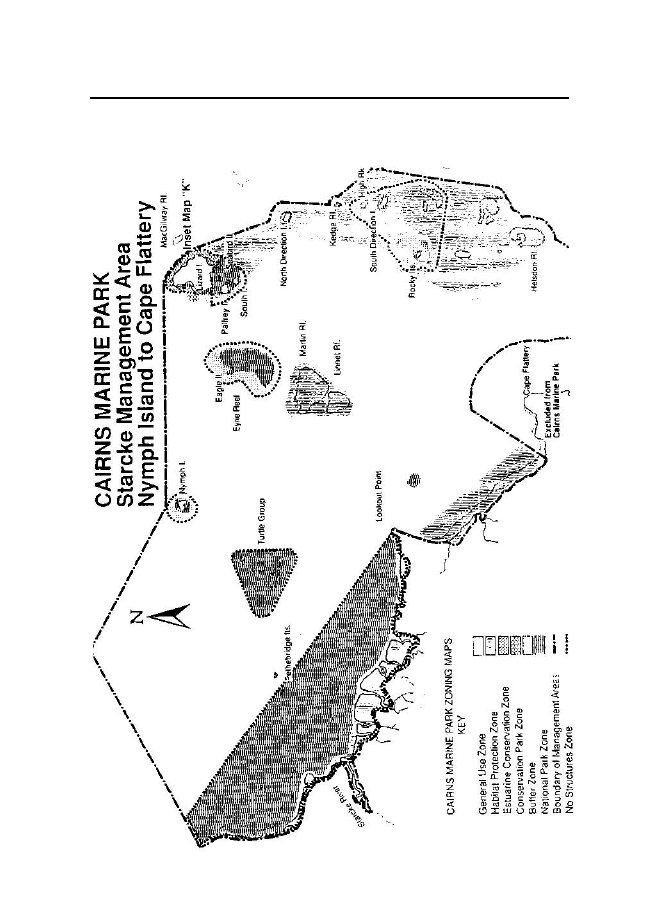
land.Starcke Management Area2.The
Starcke Management Area consists of the area the boundary ofwhich—(a)commencesattheeasternmostpointofintersectionofthecoastlineofthemainlandathighestastronomicaltidebythegeodesic that
passes through the point of latitude 14°18.27' south,longitude145°39'eastandthepointoflatitude14°40'south,longitude144°56.5'east,inthevicinityofthemouthoftheJeannie River;
and(b)runsgenerallysoutherly,south-easterly,easterly,northerly,easterly,southerlyandsouth-easterlyalongthatcoastlineathighest astronomical tide (including tidal
waters and tidal land ofall rivers, creeks and streams at
highest astronomical tide) to itsintersectionbythegeodesicthatpassesthroughthepointofintersection of the meridian of longitude
145°17.5' east with thecoastline of the mainland at low water
and the northernmost pointof intersection of the geodesic
between the easternmost point of3Now
seeNature Conservation Act 1992.4Now seeLand Act
1994.
26Marine Parks (Cairns) Zoning Plan
1992SCHEDULE 1(continued)Lookout Point at
low water and the point of latitude 14°54' south,longitude 145°20' east, by an arc of a
circle having a radius of5 km and its centre on the
northernmost point of Cape Flattery atlow water;
and(c)then north-easterly along the geodesic
to the northernmost pointof intersection of the geodesic
between the easternmost point ofLookout Point at
low water and the point of latitude 14°54' south,longitude 145°20' east by an arc of a circle
having a radius of5 km and its centre on the northernmost
point of Cape Flattery atlow water; and(d)thengenerallyeasterly,south-easterlyandsoutherlyalongthe5 km line to its intersection by the
parallel of latitude 15° south;and(e)thenwestalongthatparalleloflatitudetoitseasternmostintersectionbythecoastlineofthemainlandathighestastronomical
tide; and(f)then generally south-westerly,
southerly, south-easterly, easterlyand
north-easterly along that coastline at highest astronomical
tide(includingtidalwatersandtidallandofallrivers,creeksandstreamsathighestastronomicaltide)toitsnorthernmostintersection by
the meridian of longitude 145°20.28' east; and(g)then
north along that meridian of longitude to its intersection
bythe parallel of latitude 15°13.5' south;
and(h)then east along that parallel of
latitude to its intersection of an arcofacirclehavingaradiusof5kmanditscentreontheeasternmost point of Cape Bedford at
low water; and(i)then north-easterly along the geodesic
to the southernmost pointof the 500 m line around Three Islands
reef (reef 15–005); and(j)then generally
easterly and north-easterly along that 500 m line toits
easternmost point; and(k)then northerly
along the geodesic to the easternmost point of the500 m
line around Two Islands reef (reef 15–002); and(l)then
north-easterly along the geodesic to the southernmost
point
27Marine Parks (Cairns) Zoning Plan
1992SCHEDULE 1(continued)of the 1 km line
around Helsdon Reef (reef 14–135); and(m)then
generally north-easterly, northerly, easterly and
north-easterlyalong that 1 km line to its easternmost
point; and(n)then north-north-easterly along the
geodesic to the southernmostpoint of the
coastal 500 m line around High Rock; and(o)thengenerallynorth-easterly,northerly,north-westerlyandwesterly along that coastal 500 m line to
its northernmost point;and(p)then
north-westerly along the geodesic to the easternmost point
ofthe 500 m line around Kedge Reef (reef
14–144); and(q)then generally north-westerly and
westerly along that 500 m lineto its
northernmost point; and(r)then northerly
along the geodesic to the easternmost point of thecoastal 1 km line around North Direction
Island; and(s)then generally north-westerly and
westerly along that coastal 1 kmline to its
northernmost point; and(t)then
north-westerly along the geodesic to the easternmost point
ofthe coastal 500 m line around Lizard Island;
and(u)thengenerallynortherlyandnorth-westerlyalongthatcoastal500 m line to its
northernmost point; and(v)then westerly
along the geodesic to the northernmost point of thecoastal 500 m line around Nymph Island;
and(w)thence north-westerly along the
geodesic that passes through theeasternmost point
of the coastal 500 m line around Howick Islandto its
intersection by the geodesic between the point of latitude14°18.27' south, longitude 145°39' east and
the point of latitude14°40' south, longitude 144°56.5'
east; and(x)thensouth-westerlyalongthatgeodesictothepointofcommencement;but
excludes—(y)tidal waters and tidal land of the
Starcke River upstream of the
28Marine Parks (Cairns) Zoning Plan
1992SCHEDULE 1(continued)imaginarylinedrawnbythemeridianoflongitude144°58.25'east;
and(z)tidal waters and tidal land upstream
of the junction of the McIvorRiver and the
Morgan River.Endeavour Management Area3.The
Endeavour Management Area consists of the area the boundary
ofwhich—(a)commencesatthenorthernmostpointofintersectionofthecoastline of the mainland at highest
astronomical tide with themeridian of longitude 145°20.28' east;
and(b)runsgenerallysouth-easterly,south-westerly,south-easterly,southerly,south-westerly,south-easterly,south-westerly,southerly,easterly,south-easterlyandsouth-westerlyalongthecoastline at highest astronomical tide
(including tidal waters andtidal land of all rivers, creeks and
streams at highest astronomicaltide)totheeasternmostpointofthenorthbankoftheAnnanRiver at highest
astronomical tide; and(c)then
south-easterly along the geodesic to the point of
intersectionoftheparalleloflatitude15°33.3'southbythegeodesicthatpasses through the northernmost point of the
500 m line aroundGubbinsReef(reef15–063)andthewesternmostpointofthe500 m line around
Egret Reef (reef 15–013); and(d)then
northerly along the geodesic to the westernmost point of the500 m
line around Egret Reef; and(e)then northerly
along the geodesic to the easternmost point of the5 km
line east of the easternmost point of South Cape Bedford;and(f)then generally
north-westerly along that 5 km line to the point ofintersection by the parallel of latitude
15°13.5' south; and(g)then west along that parallel of
latitude to its intersection by themeridian of
longitude 145°20.28' east; and
29Marine Parks (Cairns) Zoning Plan
1992SCHEDULE 1(continued)(h)thensouthalongthatmeridianoflongitudetothepointofcommencement;but
excludes—(i)the area landwards of the boundary
that—(i)commencesattheeasternmostpointoftheboundaryofNational Park N.P. 206 on the south
bank of the EndeavourRiver; and(ii)runs
generally easterly along the vegetation line of the southbank
of the Endeavour River to the easternmost point of thevegetationlineofthewesternbankofthemouthofRacecourse Creek; and(iii)thenalongthevegetationlineofthewesternbankofRacecourseCreektoitsintersectionbytheriverwardsboundary of the
old railway line route along the south bankof the Endeavour
River; and(iv)thengenerallyeasterly,north-easterlyandnortherlyalongthat
riverwards boundary of the old railway line route alongthe
south bank of the Endeavour River to its intersection byan
imaginary line drawn to extend the southerly boundary ofFurneaux Street, Cooktown; and(v)then northerly along the geodesic to
the easternmost point ofthe vegetation line of the eastern
bank of the middle mouthof Chinaman Creek; and(vi)thennortherlyalongthegeodesictothenavigationaidmarked QY.4M on Navigation Chart Aus 831
published bytheHydrographicServiceRAN,20March1979,10 December 1984
Edition with small corrections 1991, 59,142, 235 and 236,
located at, or about, the point of latitude15°27.81' south,
longitude 145°14.418' east; and(vii) then east
along the parallel of latitude that passes through thatnavigation aid to its westernmost
intersection by the coastal100 m line of the southern bank of the
Endeavour River; and(viii)thengenerallynortherly,north-easterlyandeasterlyalong
30Marine Parks (Cairns) Zoning Plan
1992SCHEDULE 1(continued)that coastal 100
m line to its intersection by the meridian oflongitudethatpassesthroughthepointwherethenorthernmostboundaryofSaundersStreet,Cooktown,meets the
southern boundary of the Esplanade, Cooktown,and(ix)thensouthalongthatmeridianoflongitudetoitsnorthernmost intersection by the
coastline of the mainland athighest
astronomical tide; and(j)tidalwatersandtidallandoftheEndeavourRiverthatareupstream from an imaginary line drawn
100 m downstream fromthe Endeavour Bridge crossing of the
Cooktown-McIvor RiverRoad; and(k)tidal
waters and tidal land of the Endeavour River Right Branchthat
are upstream of the junction of the Endeavour River RightBranch and Barratt Creek.Daintree Management Area4.The
Daintree Management Area consists of the area the boundary
ofwhich—(a)commencesattheeasternmostpointofthenorthbankoftheAnnan
River at highest astronomical tide; and(b)runs
generally southerly, south-easterly, southerly,
south-easterly,southerly, south-easterly, and
south-westerly along the coastlineofthemainlandathighestastronomicaltide(includingtidalwaters and tidal land of all rivers, creeks
and streams at highestastronomicaltide)toitsintersectionbytheparalleloflatitude16°19' south;
and(c)then east along that parallel of
latitude to its intersection with thecoastline of the
mainland at low water; and(d)then
south-easterly along the geodesic to the westernmost point
ofthe 500 m line around Low Islets reef (reef
16–028); and(e)then generally south-easterly,
easterly and north-easterly, alongthat 500 m line
to its easternmost point; and
31Marine Parks (Cairns) Zoning Plan
1992SCHEDULE 1(continued)(f)thennorth-easterlyalongthegeodesictothepointoflatitude16°15' south,
longitude 145°35.5' east; and(g)then
north-westerly along the geodesic to the southernmost pointof
the 1 km line around West Hope Island reef (reef 15–064);
and(h)then north-easterly along the geodesic
to the southernmost pointof the 1 km line around East Hope
Island reef (reef 15–065); and(i)then
generally north-easterly and north-westerly along that 1 kmline
to its northernmost point; and(j)then
westerly along the geodesic to the northernmost point of the1 km
line around West Hope Island reef (reef 15–064); and(k)then westerly along the geodesic to
the easternmost point of the500 m line around
Gubbins Reef (reef 15–063); and(l)then
generally north-westerly and westerly along that 500 m lineto
the northernmost point; and(m)thennortherlyalongthegeodesicthatpassesthroughthewesternmostpointofthe500mlinearoundEgretReef(reef15–013) to its
intersection by the parallel latitude 15°33.3' south;and(n)thennorth-westerlyalongthegeodesictothepointofcommencement;but
excludes—(o)tidal waters and tidal land of the
Annan River that are upstreamfrom the
downstream side of the bridge near Lung Island, on theCooktown Development Road; and(p)tidal waters and tidal land of the Esk
River that are south of theparallel of latitude 15°34.4' south;
and(q)tidalwatersandtidallandofFritzCreekthatarewestofthewesternmostpointoftheboundaryofNationalParkN.P.212,Parish of
Monkhouse, County of Banks, on Fritz Creek; and(r)tidal
waters and tidal land of the Gap, Russell, Hislop and WillieCreeks upstream of their intersection by the
Bloomfield-RossvilleRoad; and
32Marine Parks (Cairns) Zoning Plan
1992SCHEDULE 1(continued)(s)tidal
waters and tidal land of the Bloomfield River upstream fromthe
parallel of latitude that passes through the southernmost
pointof Split Island at low water; and(t)tidal waters and tidal land of the
Daintree River and its tributariesupstream from its
junction with Barratt Creek.Port Douglas
Management Area5.The Port Douglas Management Area
consists of the area the boundaryof which—(a)commences at the easternmost
intersection of the coastline of themainland at
highest astronomical tide by the parallel of latitude16°26.3' south, in the vicinity of the
southern bank of the mouthof the Mossman River; and(b)runs east along that parallel of
latitude to its intersection by the5 km line;
and(c)then generally southerly and
south-easterly along that 5 km line toitsnorthernmostintersectionbythe500mlinearoundKoreaReef
(reef 16–080); and(d)then generally south-easterly,
southerly and south-westerly alongthat 500 m line
to its southernmost point; and(e)then
south-westerly along the geodesic to the southernmost pointof
the 500 m line around the Yule Reef (16–018); and(f)then south-westerly along the geodesic
to the easternmost point ofthecoastlineofthemainlandatWhiteCliffsathighestastronomical
tide; and(g)thengenerallynortherly,north-westerly,westerly,southerly,south-westerly,
northerly, north-easterly and northerly along thecoastline of the mainland at highest
astronomical tide (includingtidalwatersandtidallandofallrivers,creeksandstreamsathighest astronomical tide) to the point of
commencement;but excludes—(h)the
area the boundary of which—
33Marine Parks (Cairns) Zoning Plan
1992SCHEDULE 1(continued)(i)commences at the easternmost point of the
coastline of themainland on the eastern bank of the mouth of
Dicksons InletoftheboundaryofRecreationReserveR159,ParishofVictory, County of Solander;
and(ii)runs westerly along the geodesic to
the north-westernmostpoint of Reserve for Local Government
(Port and Harbours)purposes R171, Parish of Victory, County of
Solander; and(iii)then
south-easterly along the geodesic to easternmost pointof
the vegetation line of Magazine Island; and(iv)thengenerallysoutherlyandsouth-westerlyalongthatvegetation line to its southernmost
point; and(v)then southerly along the geodesic to
the easternmost point ofthe vegetation line of Ferry Reserve
R25, Parish of Victory,County of Solander; and(vi)then generally southerly,
south-easterly and south-westerlyalong that
vegetation line to its intersection by the southerlyboundarylineofReserveforLocalGovernmentR177,Parish of
Victory, County of Solander; and(vii) thensouth-easterlyalongthatsoutherlyboundaryofthatReserve to its
south-easternmost point; and(viii)then
generally northerly along the edge of alienated lands tothe
point of commencement; and(i)tidal waters and
tidal land of Dicksons inlet that are west of theeasterly boundary of the Captain Cook
Highway; and(j)tidal waters and tidal land of the
Mowbray River upstream from apoint that is 100
m seawards of the bridge crossing on the CaptainCook
Highway.Mulgrave-Johnstone Management Area6.The Mulgrave-Johnstone Management Area
consists of the area theboundary of which—(a)commencesattheeasternmostpointofthecoastlineofthe
34Marine Parks (Cairns) Zoning Plan
1992SCHEDULE 1(continued)mainland of the
south bank at the mouth of the Barron River athighest
astronomical tide; and(b)runs
south-easterly along the geodesic to the northernmost pointofthecoastlineofthemainlandatFalseCapeathighestastronomical
tide; and(c)thengenerallysouth-easterly,easterly,north-easterly,south-easterly,south-westerly,south-easterly,southerly,south-easterly, southerly, along the
coastline of the mainland athighest
astronomical tide (including tidal waters and tidal land ofall
rivers, creeks and streams at highest astronomical tide) to
itsintersection by the parallel of latitude
17°52.9' south; and(d)then east along that parallel of
latitude to its intersection by the5 km line;
and(e)then generally northerly and
north-westerly along the 5 km line toitsintersectionbythegeodesicthatpassesthroughtheeasternmost point of the 500 m line
around South Barnard Islandsreef(reef17–046)adjacenttoSistersIslandandthroughtheeasternmostpointofthe500mlinearoundKingReef(reef 17–048);
and(f)then north-easterly along the geodesic
to the easternmost point ofthe 500 m line around South Barnards
Islands reef (reef 17–046),adjacent to Sisters Island; and(g)then north-easterly along the geodesic
to the point of intersectionof the 5 km line
by the parallel of latitude 17°39.5' south; and(h)then
generally north-westerly, northerly and north-westerly alongthe 5
km line to its intersection by the parallel of latitude thatpasses through the southernmost point of the
1 km line aroundthe reef around Round Island and Russell
Island (reef 17–013);and(i)then
east along that parallel of latitude to the southernmost
pointof the 1 km line around the reef around
Round Island and RussellIsland (reef 17–013); and(j)then generally north-easterly,
northerly and north-westerly along
35Marine Parks (Cairns) Zoning Plan
1992SCHEDULE 1(continued)that 1 km line to
its northernmost intersection by the 1 km linearoundthereefaroundNormanbyIslandandMabelIsland(reef
17–012); and(k)then generally northerly and westerly
along that 1 km line to itsnorthernmost point; and(l)then north-westerly along the geodesic
to the easternmost point ofthecoastal500mlinearoundLittleFitzroyIslandtoitssouthernmost
intersection by the coastal 5 km line around FitzroyIsland; and(m)then
generally northerly and north-easterly along that coastal 5
kmline to its easternmost intersection of the
coastal 5 km line aroundLittle Fitzroy Island; and(n)thengenerallynortherlyandnorth-westerlyalongthatcoastal5 km line to its
northernmost intersection with the geodesic thatpasses through the northernmost point of the
coastal 500 m linearound Little Fitzroy Island and the
easternmost point of the 2 kmline around Green
Island reef (reef 16–049); and(o)then
northerly along the geodesic to the easternmost point of the2 km
line around Green Island reef; and(p)then
generally northerly, north-westerly and south-westerly alongthat
2 km line to its westernmost point; and(q)thensouth-westerlyalongthegeodesictothepointofcommencement;but
excludes—(r)tidalwatersandtidallandofMulgraveRiverupstreamofthenorthernmostpointofEnvironmentParkR.1548,ParishofSophia, County of Nares on the south
bank; and(s)tidal waters and tidal land of Russell
River upstream of a pointthat is 500 m downstream from its
junction with Babinda Creek;and(t)tidal waters and tidal land that
are—(i)upstream from the imaginary line
that—
36Marine Parks (Cairns) Zoning Plan
1992SCHEDULE 1(continued)(A)commences at the southernmost point of the
coastlineofthemainlandatGoodmanPointathighestastronomical
tide; and(B)runs southerly along the geodesic to
the southernmostpoint of the mainland at Goodman Point at
high water;and(C)then southerly
along the geodesic to the northernmostpoint of the
coastline of the mainland of the southernbankoftheentrancetoMourilyanHarbour,athighwater; and(D)then southerly along the geodesic to
the northernmostpoint of the coastline of the mainland of
the southernbank of the entrance to Mourilyan Harbour at
highestastronomical tide; and(ii)seawards of the imaginary line that—(A)commencesatthepointoflatitude17°36.1'south,longitude
146°6.1' east; and(B)runs south-easterly along the geodesic
to the point oflatitude 17°36.6' south, longitude 146°6.4'
east; and(C)then south along the meridian of
longitude 146°6.4' eastto its intersection by the parallel of
latitude 17°37' south;and(D)then
easterly along the geodesic to the point of latitude17°37.3' south, longitude 146°7.8 east;
and(u)tidal waters and tidal land of
Mourilyan Creek that are south of theparallel of
latitude 17°41' south; and(v)tidal waters and
tidal land of the Johnstone River upstream of animaginary line drawn north-south across the
river at the westernend of Banana Island Environmental Park at
low water; and(w)tidal waters and tidal land of Ninds
Creek, upstream of the roadcrossing at Coquette Point Road;
and(x)tidal waters and tidal land of
Liverpool Creek upstream of the
37Marine Parks (Cairns) Zoning Plan
1992SCHEDULE 1(continued)northernmostboundaryofNationalParkN.P.1608,ParishofHull, County of Nares; and(y)tidal waters and tidal land of North
Maria Creek upstream of thewesternmost point of National Park
N.P. 1445, Parish of Hull,County of Nares on its southern
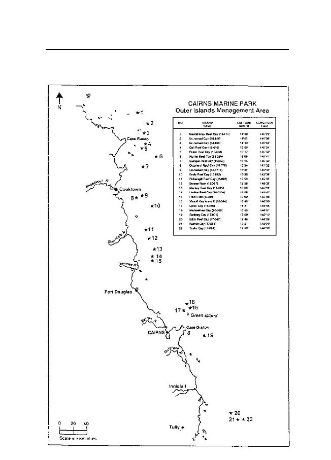
bank.Outer Islands Management Area7.(1)The Outer Islands
Management Area consists of tidal waters andtidal land—(a)that surround the islands set out in
subclause (2); and(b)that are not within the boundaries set
out in clauses 2 to 6.(2)LATITUDELONGITUDESOUTH1.MacGillivray Reef Cay (14–114)14°39'2.Unnamed Cay (14–145)14°47'3.Unnamed Cay (14–150)14°53'4.Gull
Reef Cay (15–016)15°00'5.Pasco
Reef Cay (15–018)15°17'6.Harrier Reef Cay (15–025)15°08'7.Swinger Reef Cay (15–030)15°14'8.Osterland Reef Cay (15–078)15°34'9.Unnamed Cay (15–071a)15°31'10.Emily Reef Cay (15–082)15°36'11.Pickersgill Reef Cay (15–093)15°53'12.Bonner Rock (15–097)15°58'13.Mackay Reef Cay (16–015)16°03'EAST145°29'145°36'145°33'145°34'145°32'145°41'145°33'145°32'145°33'145°38'145°35'145°38'145°39'
38Marine Parks (Cairns) Zoning Plan
1992SCHEDULE 1(continued)14.Undine Reef Cay (16–020a)15.Pratt Rock (16–021)16.Vlasoff Cay A and B (16–044)17.Upolu Cay (16–046)18.Michaelmas Cay (16–060)19.Sudbury Cay (17–001)20.Eddy
Reef Cay (17–047)21.Beaver Cay (17–051)22.Taylor Cay (17–064)16°08'16°09'16°40'16°41'16°35'17°00'17°46'17°51'17°50'145°42'145°38'146°00'145°56'146°01'146°12'146°26'146°29'146°33'
39Marine Parks (Cairns) Zoning Plan
1992¡SCHEDULE 2†ZONE
BOUNDARIESGeneral Use Zone1.The
General Use Zone consists of the tidal waters and tidal land
withinthe boundaries set out in clauses 2 to 7 of
schedule 1, that are not included inany other
zone.Habitat Protection Zone2.The
Habitat Protection Zone consists of—(1)Part
of Starcke Management Area, that consists of—(a)the
area the boundary of which—(i)commencesatthewesternmostpointofthe500mlinearound Martin
Reef (reef 14–123); and(ii)runsgenerallynorth-easterly,easterly,south-easterly,southerlyandsouth-westerlyalongthat500mlinetoitseasternmostintersectionbythe500mlinearoundLinnetReef
(reef 14–126); and(iii)then generally
south-westerly, westerly and north-westerlyalong that 500 m
line to its westernmost point; and(iv)thennortherlyalongthegeodesictothepointofcommencement; and(b)the
area the boundary of which—(i)commences at the
easternmost point of intersection of thecoastline of the
mainland at highest astronomical tide by thegeodesic that
passes through the point of latitude 14°18.27'south, longitude
145°39' east and the point of latitude 14°40'south, longitude
144°56.5 east, in the vicinity of the JeannieRiver; and(ii)runsgenerallysoutherly,south-easterly,easterlyand
40Marine Parks (Cairns) Zoning Plan
1992SCHEDULE 2(continued)northerlyalongthatcoastlineathighestastronomicaltide(including tidal waters and tidal land of
all rivers, creeks andstreamsathighestastronomicaltide)tothenorthernmostpoint of the
coastline of the mainland on Lookout Point athighest
astronomical tide; and(iii)thenalongthegeodesictothenorthernmostpointofthecoastline of the
mainland on Lookout Point at low water; and(iv)then
north-westerly along the geodesic that passes throughthe
westernmost point of the 500 m line around PethebridgeIslets reef (reef 14–122b) to the point of
intersection by thecoastal 100 m line; and(v)then
generally westerly and north-westerly along that coastal100mlinetoitsintersectionbytheparalleloflatitude14°46.3' south;
and(vi)then west along that parallel of
latitude to its intersection bythe coastline of
the mainland at low water; and(vii) thengenerallynorth-westerlyandnortherlyalongthatcoastlineatlowwatertoitsintersectionbythegeodesicbetweenthepointoflatitude14°18.27'south,longitude145°39' east and the point of latitude
14°40' south, longitude144°56.5' east; and(viii)thensouth-westalongthegeodesictothepointofcommencement;but
excludes—(ix)tidal waters and tidal land of Starke
River upstream of theimaginarylinedrawnbythemeridianoflongitude144°58.25' east;
and(c)the area the boundary of which—(i)commencesatthesouthernmostpointofthe1kmlinearound Helsdon
Reef (reef 14–135); and(ii)runs generally
westerly, north-westerly and northerly alongthat 1 km line to
its westernmost point; and
41Marine Parks (Cairns) Zoning Plan
1992SCHEDULE 2(continued)(iii)then
northerly along the geodesic to the westernmost point ofthe 1
km line around Rocky Islets reef (reef 14–132a); and(iv)then generally northerly and
north-easterly along that 1 kmline to its
northernmost point; and(v)thennorth-easterlyalongthegeodesictothewesternmostpoint of the 1 km
line around North Direction Island reef(reef 14–143);
and(vi)then north-westerly along the geodesic
to the southernmostpoint of the coastal 500 m line around
Lizard Island; and(vii) then generally north-easterly along
that coastal 500 m line toits easternmost point; and(viii)then south-easterly along the geodesic
to the northernmostpoint of the coastal 1 km line around North
Direction Island;and(ix)then generally
easterly and south-easterly along that coastal1 km line to its
easternmost point; and(x)then southerly
along the geodesic to the northernmost pointof the 500 m line
around Kedge Reef (reef 14–144); and(xi)then
generally easterly and south-easterly along that 500 mline
to its easternmost point; and(xii) then
south-easterly along the geodesic to the northernmostpoint
of the coastal 500 m line around High Rock; and(xiii)then
generally south-easterly, southerly and south-westerlyalong
that coastal 500 m line to its southernmost point; and(xiv)then southerly along the geodesic to
the easternmost point ofthe 1 km line around Helsdon Reef
(reef 14–135); and(xv) thengenerallysouth-westerly,westerly,southerlyandsouth-westerlyalongthat1kmlinetothepointofcommencement;but
excludes—(xvi) the area set out in clause
5(1)(b)(ii); and
42Marine Parks (Cairns) Zoning Plan
1992SCHEDULE 2(continued)(xvii) the area
set out in clause 5(1)(b)(iii); and(xviii) the area
set out in clause 6(1)(b)(ii); and(xix) the area
set out in clause 6(1)(b)(iii); and(d)the
area the boundary of which—(i)commences at the
easternmost point of intersection of thecoastline of the
mainland at highest astronomical tide by theparallel of
latitude 14°51' south; and(ii)runsgenerallysoutherlyandsouth-easterlyalongthatcoastline at highest astronomical tide
(including tidal watersandtidallandinallrivers,creeksandstreamsathighestastronomicaltide)toitsintersectionbythemeridianoflongitude 145°17.5' east; and(iii)then
north-easterly along the geodesic that passes through thenorthernmost point of intersection of the
geodesic betweenthe easternmost point of Lookout Point at
low water and thepoint of latitude 14°54' south, longitude
145°20' east by anarc of a circle having a radius of 5 km and
its centre on thenorthernmostpointofCapeFlatteryatlowwatertoitsintersectionbythegeodesicthatpassesthroughtheeasternmostpointofintersectionofthecoastlineofthemainlandathighestastronomicaltidebytheparalleloflatitude14°51'southandthenorthernmostpointofintersectionofthecoastlineofthemainlandathighestastronomicaltidebythemeridianoflongitude145°18.8'east;
and(iv)thennorth-westerlyalongthegeodesictothepointofcommencement; and(e)the
area the boundary of which—(i)commences at the
easternmost point of intersection of thecoastline of the
mainland at highest astronomical tide by theparallel of
latitude 15°13.5' south; and(ii)runsgenerallysouth-easterly,easterly,north-easterlyandnortherlyalongthatcoastlineathighestastronomicaltide
43Marine Parks (Cairns) Zoning Plan
1992SCHEDULE 2(continued)(including tidal
waters and tidal land in all rivers, creeks andstreamsathighestagronomicaltide)toitsnorthernmostintersectionbythemeridianoflongitude145°20.28'east;and(iii)then north along
the meridian of longitude to its intersectionby the parallel
of latitude 15°13.5' south; and(iv)thenwestalongthatparalleloflatitudetothepointofcommencement; and(f)theareaenclosedwithinthe500mlineofTwoIslandsreef(reef 15–002); and(g)the
area enclosed within the 500 m line of Low Wooded Islandreef
(reef 15–003); and(2)Part of the Daintree Management Area
that consists of—(a)the area the boundary of which—(i)commences at the point of intersection
of the coastline of themainlandathighestastronomicaltidebytheparalleloflatitude 15°36.51' south, in the
vicinity of the southern bankof Spring Creek;
and(ii)runseastalongthatparalleloflatitudetothepointofintersection of the coastline of the
mainland at low tide; and(iii)then
south-easterly along the geodesic that passes throughthe
point of latitude 15°37' south, longitude 145°20' east, toits
intersection by the coastal 500 m line of the mainland; and(iv)then generally southerly and
south-easterly along that coastal500mlinetoitsintersectionbytheparalleloflatitude15°39.88' south;
and(v)thenwestalongthatparalleltoitsintersectionbythecoastline of the mainland at highest
astronomical tide, in thevicinity of Forsberg Point; and(vi)thengenerallynorth-westerlyandnortherlyalongthatcoastline at highest astronomical tide
(including tidal watersandtidallandofallrivers,creeksandstreamsofhighest
44Marine Parks (Cairns) Zoning Plan
1992SCHEDULE 2(continued)astronomical
tide) to the point of commencement; and(b)the
area the boundary of which—(i)commencesatthenorthernmostpointofthe1kmlinearound East Hope
Island reef (reef 15–065); and(ii)runs
generally south-easterly, southerly and south-westerlyalong
that 1 km line to its southernmost point; and(iii)then
south-westerly along the geodesic to the southernmostpointofthe1kmlinearoundWestHopeIslandreef(reef
15–064); and(iv)thengenerallysouth-westerly,westerly,north-westerly,northerly,
north-easterly and easterly along that 1 km line toits
northernmost point; and(v)thenceeasterlyalongthegeodesictothepointofcommencement;but
excludes—(vi)the area set out in clause 4(3)(a);
and(c)the area the boundary of which—(i)commences at the point of intersection
of the coastline of themainland at the highest astronomical
tide by the parallel oflatitude15°50.9592'south,inthevicinityofthenorthernbank
of Fritz Creek; and(ii)runs east along that parallel to its
intersection by the coastal500 m line; and(iii)then
generally southerly and south-easterly along that coastal500 m
line to its intersection by the meridian of longitude145°22.72' east; and(iv)thensouthalongthatmeridiantoitsintersectionbythecoastline of the mainland at highest
astronomical tide; and(v)thengenerallynorth-westerlyandnortherlyalongthatcoastline at highest astronomical tide
(including tidal watersandtidallandofallrivers,creeksandstreamsathighest
45Marine Parks (Cairns) Zoning Plan
1992SCHEDULE 2(continued)astronomical
tide) to the point of commencement;but
excludes—(vi)the area set out in clause 4(3)(c);
and(vii) the area set out in clause 4(3)(d);
and(d)the area the boundary of which—(i)commences at the point of intersection
of the coastline of themainlandathighestastronomicaltidebytheparalleloflatitude 16°13.44' south; and(ii)runs east along that parallel to its
intersection by the coastal500 m line; and(iii)then
generally southerly along that coastal 500 m line to itseasternmost intersection by the parallel of
latitude 16°16.73'south; and(iv)then
south-easterly along the geodesic to the northernmostpoint
of the coastal 1 km line around Snapper Island; and(v)then generally south-easterly and
southerly along that coastal1 km line to its
easternmost point; and(vi)then
south-westerly along the geodesic to the intersection ofthe5kmlinebythegeodesicthatpassesthroughtheeasternmost intersection of the
coastline of the mainland atlowwaterbytheparalleloflatitude16°17'south,andthrough the point of latitude 16°19' south,
longitude 145°30'east; and(vii) then
north-westerly along that geodesic to its intersection bythe
coastline of the mainland at highest astronomical tide;and(viii)thengenerallynortherlyalongthecoastlineathighestastronomical tide
including tidal waters and tidal land of allrivers, creeks
and streams at highest astronomical tide to thepoint of
commencement;but excludes—
46Marine Parks (Cairns) Zoning Plan
1992SCHEDULE 2(continued)(ix)the
area set out in clause 4(3)(g);(3)Part
of the Mulgrave-Johnstone Management Area that consists of—(a)the area the boundary of which—(i)commencesatthewesternmostpointofthe1kmlinearound Green
Island reef (reef 16–049); and(ii)runsgenerallysouth-easterly,easterlyandnorth-easterlyalong that 1 km
line to its easternmost point; and(iii)then
north-easterly along the geodesic that passes through thesouthernmost point of the 1 km line around
Arlington Reef(reef16–064)toitsintersectionbythe2kmlinearoundGreen Island
reef; and(iv)then generally north-westerly and
westerly along that 2 kmlinetoitsnorthernmostintersectionbythemeridianoflongitude that passes through the
westernmost point of the1 km line around Green Island reef;
and(v)then south along that meridian of
longitude to the point ofcommencement;but
excludes—(vi)the area set out in clause 5(3)(a);
and(vii) the area set out in clause 6(3)(a);
and(b)the area the boundary of which—(i)commences at the northernmost point of
the coastal 500 mline around Little Fitzroy Island;
and(ii)runsgenerallywesterlyandsouth-westerlytoitswesternmost intersection with the
coastal 500 m line aroundFitzroy Island; and(iii)thengenerallysouth-westerly,southerly,south-westerly,southerly,south-easterly,easterly,north-easterlyandnortherlyalongthatcoastal500mlinetoitseasternmostintersection with
the coastal 500 m line around Little FitzroyIsland;
and
47Marine Parks (Cairns) Zoning Plan
1992SCHEDULE 2(continued)(iv)then
generally north-easterly, northerly and north-easterly toits
point of commencement;but excludes—(v)the
area set out in clause 4(5)(a); and(c)the
area the boundary of which—(i)commencesatthenorthernmostpointofthe1kmlinearound Tobias
Spit (reef 17–009); and(ii)runs generally
south-westerly and southerly along that 1 kmline to its
westernmost intersection by the coastal 1 km linearound High Island; and(iii)thengenerallysouth-westerly,southerly,south-easterly,easterly,
north-easterly and northerly along that coastal 1 kmline
to its easternmost intersection by the 1 km line aroundTobias Spit; and(iv)then
generally northerly, north-westerly and westerly alongthat
1 km line to the point of commencement; and(d)the
area the boundary of which—(i)commencesattheintersectionofthecoastlineofthemainlandathighestastronomicaltidebytheparalleloflatitude 17°39.5' south; and(ii)runs east along that parallel to its
intersection by the geodesicthat passes
through the easternmost point on Double Pointon the coastline
of the mainland at low water, and throughthe point of
latitude 17°43.25' south, longitude 146°07.63'east; and(iii)then
south-westerly along the geodesic to the point of latitude17°43.25' south, longitude 146°07.63' east;
and(iv)then south-easterly along the geodesic
that passes throughthe northernmost point of Stephens Island at
low water to itsnorthernmostintersectionbythe500mlinearoundsouthBarnard Islands reef (reef 17–046);
and(v)thengenerallysouth-westerly,southerly,south-easterly,
48Marine Parks (Cairns) Zoning Plan
1992SCHEDULE 2(continued)easterlyandnorth-easterlyalongthat500mlinetoitsnorthernmostintersectionbythe500mlinearoundKingReef
(reef 17–048); and(vi)then generally south-easterly along
the median line betweenKingandsouthBarnardIslandsreefstoitssouthernmostintersection by
the 500 m line around south Barnard Islandsreef; and(vii)
then generally easterly and north-easterly along that 500 mline
to its easternmost point adjacent to Sisters Island; and(viii)then south-westerly along the geodesic
that passes throughthe easternmost point of the 500 m line
around King Reef(reef 17–048) to its intersection by the 5
km line; and(ix)thengenerallysoutherlyalongthat5kmlinetoitsintersection by the geodesic that passes
through the point oflatitude 17°49' south, longitude 146°09.7'
east and throughthe intersection of the parallel of latitude
17°47.5' south ofthe coastline of the mainland at low water;
and(x)then westerly along the geodesic to
the point of intersectionof the parallel of latitude 17°49.2'
south by the coastline ofthe mainland at highest astronomical
tide; and(xi)then generally northerly along the
coastline of the mainlandat highest astronomical tide
(including tidal waters and tidalland of all
rivers, creeks and streams at highest astronomicaltide)
to the point of commencement;but
excludes—(xii) the area set out in clause 6(3)(d);
and(xiii)tidal waters and tidal land upstream
from the northernmostboundary of National Park N.P.1608,
Parish of Hull, Countyof Nares; and(e)the
area the boundary of which—(i)commences at the
northernmost intersection of the 500 mline around the
Jessie Island and Kent Island reef complex
49Marine Parks (Cairns) Zoning Plan
1992SCHEDULE 2(continued)(reef 17–043a) by
the meridian of longitude 146°10.5' east;and(ii)runssouthalongthatmeridiantoitssouthernmostintersection by
the 500 m line around the Jessie Island andKent Island reef
complex; and(iii)thengenerallysouth-easterly,easterly,north-easterly,northerlyandnorth-westerlyalongthat500mlinetothepoint
of commencement; and(f)the area the boundary of which—(i)commences at the northernmost point of
the coastline of themainland at Turtle Bay at high water;
and(ii)runs generally south-easterly and
easterly along that coastlineto the
easternmost point of Turtle Bay at high water; and(iii)thennorth-easterlyalongthegeodesictotheeasternmostpoint of the
coastline of the mainland at Turtle Bay at lowwater; and(iv)then north-westerly along the geodesic
to the northernmostpoint of the coastline of the mainland at
Turtle Bay at lowwater; and(v)thensoutherlyalongthegeodesictothepointofcommencement; and(g)the
area the boundary of which—(i)commences at the
southernmost point of the coastline of themainland at
Little Turtle Bay at high water; and(ii)runsgenerallysouth-easterly,southerly,south-westerly,southerly,easterlyandwesterlyalongthatcoastline(including tidal
waters and tidal land of all rivers, creeks andstreamsathighwater)totheeasternmostpointonthesouthern bank of
the mouth of Buddabadoo Creek at highwater; and(iii)then easterly
along the geodesic to the easternmost point ofthe coastline of
the mainland on the southern bank of the
50Marine Parks (Cairns) Zoning Plan
1992SCHEDULE 2(continued)mouth of
Buddabadoo Creek; and(iv)thennorth-easterlyalongthegeodesictotheeasternmostpoint of the
coastline of the mainland at Deception Point atlow water;
and(v)then north-easterly along the geodesic
to the southernmostpoint of the coastline of the mainland at
Little Turtle Bay atlow water; and(vi)thennorth-westerlyalongthegeodesictothepointofcommencement;but
excludes—(vii) tidal waters and tidal land that are
part of the area held underDeedofGrantinTrusttotheYarrabahAboriginalCommunity.Estuarine
Conservation Zone3.The Estuarine Conservation Zone
consists of—(1)Tidal waters and tidal land of the
Endeavour River that are within theEndeavour
Management Area and are—(a)upstream from an
imaginary line that—(i)commences at the southernmost point of
the coastline of themainland at Point Saunders, and(ii)runseasterlyalongthegeodesictotheNavigationAidlocatedat,orabout,thepointoflatitude15°27.81'south,longitude
145°14.418' east; and(iii)thensouth-easterlyalongthegeodesictothewesternmostpoint of the
vegetation line on the eastern bank of the middlemouth
of Chinamans Creek; and(iv)thensouth-easterlyalongthegeodesictothepointofintersection of the riverwards boundary of
the old railwayroute along the southern bank of the
Endeavour River by theimaginarylinethatisthecontinuationofthesoutherly
51Marine Parks (Cairns) Zoning Plan
1992SCHEDULE 2(continued)boundary of
Furneaux Street, Cooktown; and(b)downstream from the meridian of longitude
145°13.2' east; and(2)Part of the Daintree Management Area
that consists of the area theboundary of
which—(i)commences at the easternmost point of
the mainland of thenorthern bank of the Annan River at highest
astronomicaltide; and(ii)runsgenerallysoutherly,south-easterly,easterly,north-easterly along the coastline at
highest astronomical tide(including tidal waters and tidal land
of all rivers, creeks andstreamsathighestastronomicaltide)tothenorthernmostpoint of the
coastline of the mainland at Grave Point at thehighest
astronomical tide; and(iii)then generally
north-easterly along the geodesic that passesthroughthesouthernmostpointofthe500mlinearoundDawson Reef to its intersection by the
geodesic that passesthroughtheeasternmostpointofthenorthbankoftheAnnan
River at the highest astronomical tide and the point ofintersectionofthegeodesicthatpassesthroughthenorthernmost point of the 500 m line
around Gubbins Reef(reef 15–063) and the westernmost point of
the 500 m linearound Egret Reef (reef 15–013) by the
parallel of latitude15°33.3' south; and(iv)thennorth-westerlyalongthegeodesictothepointofcommencement;but
excludes—(v)tidalwatersandtidallandoftheAnnanRiverthatareupstreamfromthebridgenearLungIsland,ontheCooktown Development Road; and(vi)tidal waters and tidal land of the Esk
River that are south ofthe parallel of latitude 15°34.4'
south; and(3)Part of the Port Douglas Management
Area that consists of—
52Marine Parks (Cairns) Zoning Plan
1992SCHEDULE 2(continued)(a)the
area the boundary of which—(i)commences at the
northernmost point of the coastline of themainlandontheeasternbankofthemouthofDicksonsInlet; and(ii)runsnorthalongthemeridianoflongitudethatpassesthroughthatpointtoitssouthernmostintersectionbythecoastal 500 m line; and(iii)then generally
north-westerly along that coastal 500 m line toits intersection
by the parallel of latitude that passes throughthe point of
intersection by the coastline of the mainland athighestastronomicaltidebyanimaginarylinedrawntoextend the southerly boundary of Melaleuca
Drive; and(iv)then west along that parallel to its
easternmost intersection bythe coastline of the mainland at
highest astronomical tide;and(v)thengenerallysoutherly,south-westerly,north-easterly,northerly and
easterly along the coastline of the mainland athighest
astronomical tide to the point of commencement;but
excludes—(vi)tidalwatersandtidallandthatarewestoftheeasterlyboundary of the Captain Cook Highway;
and(vii) the area the boundary of which—(A)commences at the easternmost point of
the coastline ofthemainlandontheeasternbankofthemouthofDicksons Inlet of the boundary of
Recreation ReserveR159, Parish of Victory, County of Solander;
and(B)runswesterlyalongthegeodesictothenorth-westernmostpointofReserveforLocalGovernment(PortandHarbours)purposesR171,Parish of
Victory, County of Solander; and(C)then
south-easterly along the geodesic to easternmostpoint
of the vegetation line of Magazine Island; and
53Marine Parks (Cairns) Zoning Plan
1992SCHEDULE 2(continued)(D)then
generally southerly and south-westerly along thatvegetation line to its southernmost point;
and(E)thensoutherlyalongthegeodesictotheeasternmostpointofthevegetationlineofFerryReserveR25,Parish of Victory, County of Solander;
and(F)thengenerallysoutherly,south-easterlyandsouth-westerlyalongthatvegetationlinetoitsintersection by
the southerly boundary line of Reservefor Local
Government R177, Parish of Victory, Countyof Solander;
and(G)thensouth-easterlyalongthatsoutherlyboundaryofthat Reserve to its south-easternmost
point, and(H)thengenerallynortherlyalongtheedgeofalienatedlands to the
point of commencement; and(viii)tidalwatersandtidallandofthereducedareaofSpecialLease
09/23884 over Lot 136 on Plan SR 550 detailed onCairns Marine Park Plan No. 1 held at the
Cairns office ofthe Department of Environment and Heritage;
and(b)the area the boundary of which—(i)commences at the easternmost point of
the coastline of themainlandonthesouthernbankoftheMowbrayRiverathighest astronomical tide; and(ii)runsnorth-eastalongthegeodesictoitseasternmostintersectionbythereefedgeofAlexanderReef(reef
16–039); and(iii)then generally
north-westerly along that reef edge to its pointof
intersection by the coastline of the mainland at low water;and(iv)then west along
the parallel of latitude that passes throughthat point to its
easternmost intersection by the coastline ofthe mainland at
highest astronomical tide; and(v)thengenerallysouth-easterlyalongthecoastlineofthe
54Marine Parks (Cairns) Zoning Plan
1992SCHEDULE 2(continued)mainland at
highest astronomical tide (including tidal watersandtidallandofallriverscreeksandstreamsathighestastronomical
tide) to the point of commencement;but
excludes—(vi)tidal waters and tidal land of the
Mowbray River upstream ofa point that is 100 m downstream of
the bridge crossing onthe Captain Cook Highway; and(4)Part of the Mulgrave-Johnstone
Management Area that consists of—(a)the
area the boundary of which—(i)commences at the
northernmost point of the coastline of themainland at False
Cape at highest astronomical tide; and(ii)runsgenerallysouth-easterly,easterlyandnorth-easterlyalong that
coastline at highest astronomical tide (includingtidal
waters and tidal land of all rivers, creeks and streams athighest astronomical tide) to the
northernmost point of CapeGrafton at highest astronomical tide;
and(iii)thenalongthegeodesictothenorthernmostpointofthecoastline of the
mainland at Cape Grafton at low water; and(iv)thenalongthegeodesictothenorthernmostpointofthemainland at False
Cape at low water; and(v)southerly along
the geodesic to the point of commencement;but
excludes—(vi)tidal waters and tidal land that are
part of the Deed of Grantin Trust to the Yarrabah Aboriginal
Community; and(b)tidal waters and tidal land of the
Mulgrave River, Russell Riverand Mutchero
Inlet that are—(i)upstream from the imaginary line
that—(A)commences at the easternmost point of
the coastline ofthe mainland on Flirt Point at highest
astronomical tide;and(B)runs then
easterly along the geodesic to the easternmost
55Marine Parks (Cairns) Zoning Plan
1992SCHEDULE 2(continued)point of the
coastline of the mainland on Flirt Point athigh water;
and(C)thensoutherlyalongthegeodesictotheeasternmostpoint of the
coastline of the mainland on ConstantinePoint at high
water; and(D)then westerly along the geodesic the
easternmost pointof the coastline of the mainland on
Constantine Point athighest astronomical tide; and(ii)downstreamofthenorthernmostpointofEnvironmentalParkR1548,ParishofSophia,CountyofNares,onthesouth bank of the Mulgrave
River;but excludes—(iii)tidal
waters and tidal land of the Russell River that are southof
the parallel of latitude 17°15' south; and(c)tidal
waters and tidal land that are—(i)upstream from an imaginary line that—(A)commences at the easternmost point of
the coastline ofthemainlandatFlyingFishPointathighestastronomical
tide; and(B)runssoutherlyalongthegeodesictotheeasternmostpointofthecoastlineofthemainlandatFlyingFishPoint
at high water; and(C)thensouth-easterlyalongthegeodesictotheeasternmostpointofthecoastlineofthemainlandatThompson Point at high water;
and(D)thence westerly along the geodesic to
the easternmostpointofthecoastlineofthemainlandatThompsonPoint at highest
astronomical tide; and(ii)eastofthemeridianoflongitudethatpassesthroughthewesternmost point of Banana Island
Environmental Park atlow water; and(iii)downstream of the road crossing of Coquette
Point Road on
56Marine Parks (Cairns) Zoning Plan
1992SCHEDULE 2(continued)Ninds Creek;
and(d)tidal waters and tidal land of the
Moresby River, Mourilyan Creekand their
tributaries that are—(i)upstream from the
imaginary line that—(A)commencesatthepointoflatitude17°36.1'south,longitude
146°6.1' east; and(B)runs south-easterly along the geodesic
to the point oflatitude 17°36.6' south, longitude 146°6.4'
east; and(C)then south along the meridian of
longitude 146°6.4' eastto its intersection by the parallel of
latitude 17°37' south;and(D)then
easterly along the geodesic to the point of latitude17°37.3' south, longitude 146°7.8' east;
and(ii)downstream from the junction of Little
Moresby Creek onthe Moresby River; and(iii)north
of the parallel of latitude 17°38.9' south on MourilyanCreek.Conservation Park
Zone4.The Conservation Park Zone consists
of—(1)Part of the Starcke Management Area
that consists of—(a)the area the boundary of which—(i)commencesatthewesternmostpointofthecoastlineofLizard Island on South Bay Point at
high water; and(ii)runs westerly along the geodesic to
the westernmost point ofthecoastlineofLizardIslandonSouthBayPointatlowwater; and(iii)then
west along the parallel of latitude that passes throughthatpointtoitswesternmostintersectionbythecoastal500 m line around
Lizard Island; and
57Marine Parks (Cairns) Zoning Plan
1992SCHEDULE 2(continued)(iv)thengenerallynortherly,north-easterly,easterly,south–easterly,southerlyandsouth-westerlyalongthatcoastal500mlinetoitsintersectionbythegeodesicthatpassesthroughthepointoflatitude14°41.524'south,longitude
145°28.434' east and the easternmost point of thecoastline of Lizard Island on Lizard Head at
low water, beingthe approximate bearing of the ridge that
terminates at LizardHead; and(v)thence north-westerly along that geodesic to
the easternmostpoint of the coastline of Lizard Island on
Lizard Head at lowwater; and(vi)thennorth-westerlyalongthegeodesictotheeasternmostpoint of the
coastline of Lizard Island on Lizard Head at highwater; and(vii) thengenerallynorth-westerly,northerly,easterly,north-easterly,
northerly, north-westerly, westerly, southerlyand
south-westerly along that coastline at high water to thepoint
of commencement;but excludes—(viii)the area
set out in clause 6(1)(f); and(b)the
area the boundary of which—(i)commencesatthepointofintersectionoftheparalleloflatitude15°05'southbythecoastlineofthemainlandathighest astronomical tide; and(ii)runsgenerallysoutherlyalongthatcoastlineathighestastronomical tide
(including tidal waters and tidal land of allrivers, creeks
and streams at highest astronomical tide) to itsintersection by the parallel of latitude
15°13.5' south; and(iii)then east along
that parallel to its intersection by the meridianof
longitude 145°20.28' east, in the vicinity of Cape Bedford;and(iv)thennorth-westerlyalongthegeodesictothepointofintersectionoftheparalleloflatitude15°05'southbythe
58Marine Parks (Cairns) Zoning Plan
1992SCHEDULE 2(continued)coastline of the
mainland at low water; and(v)then west along
that parallel to the point of commencement;but
excludes—(vi)tidal waters and tidal land of the
McIvor upstream from itsjunction with the Morgan River;
and(2)Part of the Endeavour Management Area
that consists of—(a) tidal waters and tidal land of the
Endeavour River that are—(i)upstream from the
meridian of longitude 145°13.2' east; and(ii)downstream from a point that is 100 m
downstream fromtheEndeavourBridgecrossingontheCooktown–McIvorRiver Road.;
and(b)tidal waters and tidal land of the
Endeavour River Right Branchthat are—(i)upstream from its junction with the
Endeavour River; and(ii)downstreamfromitsjunctionwithBarrettCreek(BarrattCreek);
and(3)Part of the Daintree Management Area
that consists of—(a)the area the boundary of which—(i)commencesatthenorthernmostpointofthe500mlinearound East Hope
Island reef (reef 15–065); and(ii)runs
generally south-easterly, southerly and south-westerlyalong
that 500 m line to its southernmost point; and(iii)then
south-westerly along the geodesic to the southernmostpointofthe500mlinearoundWestHopeIslandreef(reef
15–064); and(iv)then generally north-westerly,
northerly, north-easterly andeasterly along
that 500 m line to its northernmost point; and(v)theneasterlyalongthegeodesictothepointofcommencement; and
59Marine Parks (Cairns) Zoning Plan
1992SCHEDULE 2(continued)(b)the
area the boundary of which—(i)commences at the
easternmost point of intersection of thecoastline of the
mainland at highest astronomical tide by theparalleloflatitude15°39.88'south,inthevicinityofForsberg Point; and(ii)runs
east along that parallel to its intersection by the coastal500 m
line; and(iii)then generally
south-easterly along that coastal 500 m line toitseasternmostintersectionbytheparalleloflatitude15°45.968' south;
and(iv)thenwestalongthatparalleltoitsintersectionbythecoastline of the mainland at highest
astronomical tide, in thevicinity of Obree Point; and(v)then generally north-westerly along
that coastline at highestastronomicaltide(includingtidalwatersandtidallandofrivers, creeks and streams at highest
astronomical tide) to thepoint of commencement; and(c)tidal waters and tidal land of Bauer
Inlet, the Gap, Russell, Hislopand Willie Creeks
that are—(i)upstream from an imaginary line
that—(A)commences at the southernmost point of
the mainlandonthenorthbankoftheentrancetoBauerInletathighest astronomical tide; and(B)runs southerly along the geodesic to
the southernmostpoint of the mainland on the north bank of
the entranceto Bauer Inlet at high water; and(C)then southerly along the geodesic to
the northernmostpoint of the mainland on the south bank of
the entranceto Bauer Inlet at high water; and(D)then southerly along the geodesic to
the northernmostpoint of the mainland on the south bank of
the entranceto Bauer Inlet at highest astronomical tide;
and
60Marine Parks (Cairns) Zoning Plan
1992SCHEDULE 2(continued)(ii)downstream from the Bloomfield-Rossville
Road; and(d)tidal waters and tidal land of the
Bloomfield River that are—(i)upstream from an
imaginary line that—(A)commences at the easternmost point of
the mainland onthe north bank of the mouth of the
Bloomfield River athighest astronomical tide; and(B)runseasterlyalongthegeodesictotheeasternmostpoint of the
mainland on the north bank of the mouth ofthe Bloomfield
River at high water; and(C)then generally
south-easterly along the geodesic to theeasternmost point
of the mainland on the south bank ofthe mouth of the
Bloomfield River at high water; and(D)thenwesterlyalongthegeodesictotheeasternmostpoint of the
mainland on the south bank of the mouth ofthe Bloomfield
River at highest astronomical tide; and(ii)downstream of the parallel of longitude that
passes throughthe southernmost point of Spit Island at low
water; and(e)the area the boundary of which—(i)commences at the easternmost point of
intersection of thecoastline of the mainland at highest
astronomical tide by theparallel of latitude 16°05' south,
south of Cape Tribulation;and(ii)runs
east along that parallel to its easternmost intersection bythe
coastal 500 m line; and(iii)then generally
southerly along that coastal 500 m line to itsintersection by
the parallel of latitude 16°13.44' south; and(iv)thenwestalongthatparalleltoitsintersectionbythecoastline of the mainland at highest
astronomical tide, southof Bailey Point; and(v)thengenerallynortherlyalongthatcoastlineathighestastronomical tide
(including tidal waters and tidal land of allrivers, creeks
and streams at highest astronomical tide) to the
61Marine Parks (Cairns) Zoning Plan
1992SCHEDULE 2(continued)point of
commencement; and(f)tidalwatersandtidallandoftheDaintreeRiveranditstributaries—(i)upstream from an imaginary line that—(A)commences at the easternmost point of
the coastline ofthe mainland on the northern bank of the
mouth of theDaintree River at highest astronomical tide;
and(B)runseasterlyalongthegeodesictotheeasternmostpoint of the
coastline of the mainland on the northernbank of the mouth
of the Daintree River at high water;and(C)thensouth-westerlyalongthegeodesictotheeasternmost point of the coastline of
the mainland onthe southern bank of the mouth of the
Daintree River athigh water; and(D)thenwesterlyalongthegeodesictotheeasternmostpoint of the
coastline of the mainland on the southernbankofthemouthoftheDaintreeRiverathighestastronomical
tide; and(ii)downstream of the junction of the
Daintree River and BarrattCreek;but
excludes—(iii)the area set out
in clause 6(2)(d); and(g)theareaenclosedwithinthereefedgeofSnapperIslandreef(reef 16–006); and(4)Part
of the Port Douglas Management Area that consists of—(a)the area the boundary of which—(i)commences at the easternmost point of
the coastline of themainlandonthesouthernbankoftheMowbrayRiverathighest astronomical tide; and(ii)runsnorth-eastalongthegeodesictoitseasternmost
62Marine Parks (Cairns) Zoning Plan
1992SCHEDULE 2(continued)intersectionbythereefedgeofAlexanderReef(reef
16–039); and(iii)thengenerallysoutherlyalongthatreefedgetoitssouthernmostpointofintersectionbythecoastlineofthemainland at low water; and(iv)then west along the parallel of
latitude that passes throughthat point to its
intersection by the coastline of the mainlandat highest
astronomical tide; and(v)thengenerallynorth-westerlyalongthecoastlineofthemainland at highest astronomical tide
(including tidal watersandtidallandofallrivers,creeksandstreamsathighestastronomical
tide) to the point of commencement; and(5)Part
of the Mulgrave-Johnstone Management Area that consists of—(a)the area the boundary of which—(i)commences at the southernmost point of
Fitzroy Island athigh water; and(ii)runssouthalongthemeridianoflongitudethatpassesthrough that
point to its intersection by the coastal 200 m lineof
Fitzroy Island; and(iii)then generally
north-westerly, northerly and north-easterlyalong that
coastal 200 m line to its westernmost intersectionby
the coastal 200 m line around Little Fitzroy Island; and(iv)then generally northerly and
north-easterly along that coastal200 m line to its
northernmost point; and(v)then southerly
along the geodesic to the northernmost pointofthecoastlineofLittleFitzroyIslandathighestastronomical
tide; and(vi)then generally south-westerly,
southerly and easterly alongthat coastline at
highest astronomical tide to its southernmostpoint; and(vii)
thensouth-westerlyalongthegeodesictotheeasternmostpoint on the
coastline of Fitzroy Island at high water; and
63Marine Parks (Cairns) Zoning Plan
1992SCHEDULE 2(continued)(viii)then
generally north-westerly, south-westerly, southerly andsouth-easterly along that coastline at high
water to the pointof commencement; and(b)the
area the boundary of which—(i)commencesatthenorthernmostpointofthe500mlinearound Normanby
and Mabel Islands and Grange Rock reef(reef 17–012a);
and(ii)runs generally easterly and
south-easterly along that 500 mline to its
northernmost intersection by the 500 m line aroundRound
and Russell Islands reef (reef 17–013); and(iii)then
generally south-easterly, southerly, south-westerly andwesterlyalongthat500mlinetoitssouthernmostintersectionbythe500mlinearoundJonesPatch(reef 17–012b);
and(iv)then generally westerly,
north-westerly and northerly alongthat 500 m line
to its southernmost intersection by the 500 mline around
Normanby and Mabel Islands and Grange Rockreef (reef
17–012a); and(v)then generally north-westerly,
northerly and north-easterlyalong that 500 m
line to the point of commencement; and(c)the
area the boundary of which—(i)commencesatthenorthernmostpointofthe500mlinearound Bresnahan
Island reef (reef 17–043b); and(ii)runs
generally easterly and southerly along that 500 m line toits
intersection by the 500 m line around Jessie Island andKent
Island reef complex (reef 17–043a); and(iii)thengenerallyeasterlyalongthat500mlinetoitsnorthernmostintersectionbythemeridianoflongitude146°10.5' east;
and(iv)thensouthalongthatmeridiantoitssouthernmostintersection by
the 500 m line around the Jessie Island andKent Island reef
complex; and
64Marine Parks (Cairns) Zoning Plan
1992SCHEDULE 2(continued)(v)thengenerallynorth-westerlyalongthat500mlinetoitssouthernmostintersectionbythe500mlinearoundHutchison Island
reef (reef 17–043c); and(vi)then generally
north-westerly, northerly and north-easterlyalong that 500 m
line to its intersection with the 500 m linearound Bresnahan
Island reef (reef 17–043b); and(vii) then
generally northerly and north-easterly along that 500 mline
to the point of commencement; and(d)tidal
waters and tidal land of the Russell River that are—(i)south of the parallel of latitude
17°15' south; and(ii)downstream of a point that is 500 m
downstream from thejunction of the Russell River and Babinda
Creek.Buffer Zone5.The
Buffer Zone consists of—(1)Part of the
Starcke Management Area that consists of—(a)theareaenclosedwithinthe500mlineofEyrieReef(reef
14–118) but excluding the area set out in clause 6(1)(a);
and(b)the areas enclosed within the coastal
500 m line of each of thefollowing islands—(i)Nymph
Island;(ii)South Direction Island;(iii)Rocky
Islets;(iv)Three Islands;but
excluding—(v)the areas set out in clause 6(1)(b);
and(c)the area the boundary of which—(i)commencesatthewesternmostpointofthecoastlineofLizard Island on South Bay Point at
low water; and
65Marine Parks (Cairns) Zoning Plan
1992SCHEDULE 2(continued)(ii)runs
west along the parallel of latitude that passes throughthatpointtoitswesternmostintersectionbythecoastal500 m line around
Lizard Island; and(iii)thengenerallysoutherly,south-easterly,easterlyandnorth-easterly along that coastal 500
m line to its easternmostintersection by the parallel of
latitude that passes through thesouthernmost
point of the coastline on the south-eastern endof South Island
at low water; and(iv)then west along that parallel to the
southernmost point of thecoastlineonthesouth-easternendofSouthIslandatlowwater; and(v)then north-westerly along the geodesic
to the southernmostpointofthecoastlineonthesouth-easternendofSouthIsland at high
water; and(vi)thengenerallywesterlyandnorth-westerlyalongthatcoastline at high water to its
westernmost point; and(vii) then westerly along the geodesic
to the westernmost point ofthe coastline of South Island at low
water; and(viii)then north-westerly along the geodesic
to the southernmostpoint of the coastline of Palfrey Island at
low water; and(ix)then northerly along the geodesic to
the southernmost pointof the coastline of Palfrey Island at
high water; and(x)then generally westerly,
north-westerly and northerly alongthat coastline at
high water to its westernmost point; and(xi)then
westerly along the geodesic to the westernmost point ofPalfrey Island at low water; and(xii)
thennortherlyalongthegeodesictothepointofcommencement; and(2)PartoftheDaintreeManagementAreathatconsistsoftheareaenclosed within the 500 m line around Low
Islets reef (reef 16–028) butexcludes the area
set out in clause 6(2)(a); and(3)Part
of the Mulgrave-Johnstone Management Area that consists
of—
66Marine Parks (Cairns) Zoning Plan
1992SCHEDULE 2(continued)(a)theareaenclosedwithinthe500mlineofGreenIslandreef(reef 16–049) but excluding the area
set out in clause 6(3)(a); and(b)the
area the boundary of which—(i)commences at the
northernmost point of intersection of the500 m line around
King Reef (reef 17–048) by the 500 mline around South
Barnard Islands reef (reef 17–046); and(ii)runs
generally south-easterly along the median line betweenKingandSouthBarnardIslandsreefstoitssouthernmostintersection by
the 500 m line around South Barnard Islandsreef; and(iii)then generally
easterly, north-easterly, northerly, westerly,south-westerlyandsoutherlyalongthat500mlinetothepoint
of commencement;but excludes—(iv)the
area set out in clause 6(3)(c).National Park
Zone6.The National Park Zone consists
of—(1)Part of the Starcke Management Area
that consists of—(a)EyrieReef(reef14–118)locatedat,orabout,latitude14°43'south, longitude
145°23' east, the area depicted in dark green onInset
E of the Zoning Map in the Cairns Section Zoning Plan; and(b)the areas enclosed within the line
every point of which is 100 mseaward from the
nearest point of the coastline at low water ofeach of the
following islands—(i)Nymph Island;(ii)South
Direction Island;(iii)Rocky
Islets;(iv)Three Islands; and(c)theareaenclosedwithinthe500mlineofDecapolisReef
67Marine Parks (Cairns) Zoning Plan
1992SCHEDULE 2(continued)(reef 14–131);
and(d)the area the boundary of which—(i)commencesatthewesternmostpointofthe500mlinearound
Pethebridge Islets reef (reef 14–122b); and(ii)runsnorth-westerlyalongthegeodesicthatpassesatatangenttothecoastlineofthemainlandatlowwateronMurdoch Point, to its intersection by the
geodesic betweenthe point of latitude 14°18.27' south,
longitude 145°39' eastand the point of latitude 14°40'
south, longitude 144°56.5'east; and(iii)then
south-westerly along that geodesic to its intersection bythe
coastline of the mainland at low water; and(iv)then
generally south-easterly along that coastline at low waterto
its intersection by the parallel of latitude 14°46.3' south;and(v)then east along
that parallel of latitude to its intersection bythe
coastal 100 m line; and(vi)then generally
south-easterly and easterly along that coastal100mlinetoitsintersectionbythegeodesicthatpassesthroughthenorthernmostpointonLookoutPointonthecoastline of the
mainland at low water and the westernmostpointofthe500mlinearoundPethebridgeIsletsreef(reef 14–112b); and(vii)
thennorth-westerlyalongthatgeodesictothepointofcommencement; and(e)the
area the boundary of which—(i)commencesattheeasternmostpointofthecoastlineofLizard Island on Lizard Head at high
water; and(ii)runsalongthegeodesictotheeasternmostpointofthecoastline of
Lizard Island on Lizard Head at low water; and(iii)then
south-easterly along the geodesic that passes throughthe
point of latitude 14°41.524' south, longitude
145°28.434'
68Marine Parks (Cairns) Zoning Plan
1992SCHEDULE 2(continued)east to its
intersection by the coastal 500 m line of LizardIsland; and(iv)then
generally south-westerly along that coastal 500 m line toits
intersection by the parallel of latitude that passes throughthe
southernmost point of the coastline on the south-easternend
of South Island at low water; and(v)then
west along that parallel to the southernmost point of thecoastlineonthesouth-easternendofSouthIslandatlowwater; and(vi)then north-westerly along the geodesic
to the southernmostpointofthecoastlineonthesouth-easternendofSouthIsland at high
water; and(vii) thengenerallynorth-easterly,northerly,westerly,south-westerlyandsoutherlyalongthatcoastlineathighwater to its westernmost point;
and(viii)then westerly along the geodesic to
the westernmost point ofthe coastline of South Island at low
water; and(ix)then north-westerly along the geodesic
to the southernmostpoint of the coastline of Palfrey Island at
low water; and(x)then northerly along the geodesic to
the southernmost pointof the coastline of Palfrey Island at
high water; and(xi)thengenerallyeasterly,north-easterly,northerly,north-westerly,westerlyandsouth-westerlyalongthatcoastline at high water to its
westernmost point; and(xii) then westerly along the geodesic
to the westernmost point ofthe coastline of Palfrey Island at low
water; and(xiii)then northerly along the geodesic to
the westernmost point ofthecoastlineofLizardIslandonSouthBayPointatlowwater; and(xiv)then
easterly along the geodesic to the westernmost point ofthe
coastline of Lizard Island on South Bay Point at highwater; and
69Marine Parks (Cairns) Zoning Plan
1992SCHEDULE 2(continued)(xv) thengenerallysouth-easterly,southerly,easterly,north-easterly,
easterly and south-easterly along that coastlineat
high water to the point of commencement; and(f)the
area the boundary of which—(i)commences at the
westernmost intersection of the parallel oflatitude
14°39.077' south by the coastline of Lizard Island athigh
water in the vicinity of a distinctive split in the rockface;
and(ii)runsthengenerallysoutherly,south-easterlyandsouth-westerlyalongthatcoastlineathighwatertoitswesternmost point adjacent to
Chinamans Ridge; and(iii)then
north-westerly along the geodesic to the westernmostpoint
of the coastline of Lizard Island at low water, adjacentto
Chinamans Ridge; and(iv)then north-westerly along the geodesic
that passes throughthe point of longitude 14°39.56' south,
longitude 145°26.52'east, being the approximate bearing of the
direction of thesouthern side of Chinamans Ridge, to its
intersection by thereef edge around Lizard Island; and(v)thengenerallynortherlyalongthatreefedgetoitswesternmostintersectionbytheparalleloflatitude14°39.077' south;
and(vi)then east along that parallel to the
point of commencement;and(g)the
area the boundary of which—(i)commencesatthesouthernmostpointofthe500mlinearound Turtle
Reef (reef 14–119b); and(ii)runs generally
north-westerly, northerly and north-easterlyalong that 500 m
line to its northernmost point; and(iii)then
north-easterly along the geodesic to the northernmostpointofthe500mlinearoundTurtleGroupreef(reef
14–120e); and
70Marine Parks (Cairns) Zoning Plan
1992SCHEDULE 2(continued)(iv)thengenerallysouth-easterlyalongthat500mlinetoitseasternmost point; and(v)then
southerly along the geodesic to the easternmost point ofthe
500 m line around Turtle Group reef (reef 14–120i); and(vi)thengenerallysouth-westerlyalongthat500mlinetoitssouthernmost point; and(vii) then
north-westerly along the geodesic to the southernmostpointofthe500mlinearoundTurtleGroupreef(reef
14–120a); and(viii)thennorth-westerlyalongthegeodesictothepointofcommencement; and(2)Part
of the Daintree Management Area that consists of—(a)Low Islets reef (reef 16–028), the
area depicted in dark green onInset N of the
Zoning Map in the Cairns Section Zoning Plan;and(b)the area the boundary of which—(i)commencesattheintersectionoftheparalleloflatitude15°45.968' south
by the coastline of the mainland at highestastronomical
tide, in the vicinity of Obree Point; and(ii)runsgenerallysoutherly,easterly,south-easterlyandsoutherlyalongthatcoastlineathighestastronomicaltide(including tidal waters and tidal land of
all rivers, creeks andstreams at highest astronomical tide)
to its intersection by theparallel of latitude 15°50.9592'
south, in the vicinity of thenorthern bank of
Fritz Creek; and(iii)then east along
that parallel to its intersection by the coastal500 m
line; and(iv)thengenerallynortherly,north-westerly,westerlyandnortherly along that coastal 500 m
line to its intersection bythe parallel of latitude 15°45.968'
south; and(v)then west along that parallel to the
point of commencement;and
71Marine Parks (Cairns) Zoning Plan
1992SCHEDULE 2(continued)(c)the
area the boundary of which—(i)commencesattheintersectionoftheparalleloflatitude16°05'southbythecoastlineofthemainlandathighestastronomical
tide, south of Cape Tribulation; and(ii)runsgenerallynortherlyandnorth-westerlyalongthatcoastline at highest astronomical tide
(including tidal watersandtidallandofallrivers,creeksandstreamsathighestastronomicaltide)toitsintersectionbythemeridianoflongitude 145°22.72' east; and(iii)thennorthalongthatmeridiantoitsintersectionbythecoastal 500 m line of the mainland;
and(iv)then generally southerly along that
coastal 500 m line to itseasternmostintersectionbytheparalleloflatitude16°05'south; and(v)then
west along that parallel to the point of commencement;and(d)tidal waters and
tidal land of the Daintree River south arm, southof
the parallel of latitude 16°17.6' south; and(3)Part
of The Mulgrave-Johnstone Management Area that consists of—(a)Green Island reef (reef 16–049), the
area depicted in dark greenon Inset R of the Zoning Map in the
Cairns Section Zoning Plan;and(b)the
area enclosed within the reef edge of Normanby and MableIslands and Grange Rock reef (reef 17–012a);
and(c)the area enclosed within the line
every point of which is 100 mseawards from the
nearest point of coastline at low water fromSouth Barnard
Islands; and(d)tidal waters and tidal land of
Mourilyan Creek that are—(i)south of the
parallel of latitude 17°38.9' south; and(ii)north
of the parallel of latitude 17°41' south; and(e)tidal
waters and tidal land of Maria Creek and North Maria
Creek
72Marine Parks (Cairns) Zoning Plan
1992SCHEDULE 2(continued)that are—(i)upstream of the easternmost crossing
of Maria Creek by theboundary of National Park N.P.1445,
Parish of Hull, Countyares; and(ii)downstream of the westernmost boundary of
National ParkN.P.1445 on North Maria Creek on its south
bank.No Structures Zone7.The
No Structures Zone consists of—(1)Part
of the Starcke Management Area that consists of—(a)the areas enclosed within the 500 m
line of the following reefs—(i)Nymph
Island reef (reef 14–115);(ii)Eyrie Reef (reef
14–118);(iii)Two Islands reef
(reef 15–002);(iv)Low Wooded Island reef (reef
15–003);(v)Three Islands reef (reef 15–005);
and(b)the area the boundary of which—(i)commences at the northernmost point on
Lookout Point onthe coastline of the mainland at highest
astronomical tide;and(ii)runs northerly
along the geodesic to the northernmost pointofthecoastlineofthemainlandofLookoutPointatlowwater; and(iii)then
north-westerly along the geodesic to the westernmostpointofthe500mlinearoundPethebridgeIsletsreef(reef 14–122b); and(iv)thennorth-westerlyalongthegeodesicthatpassesatatangenttothecoastlineofthemainlandatlowwateronMurdoch Point, to its intersection by the
geodesic betweenthe point of latitude 14°18.27' south,
longitude 145°39' east
73Marine Parks (Cairns) Zoning Plan
1992SCHEDULE 2(continued)and the point of
latitude 14°40' south, longitude 144°56.5'east; and(v)then south-westerly along that
geodesic to its intersection bythe coastline of
the mainland at highest astronomical tide;and(vi)then generally south-easterly along
that coastline at highestastronomical tide (including tidal
waters and tidal land of allrivers, creeks
and streams at highest astronomical tide) to thepoint
of commencement;but excludes—(vii) tidal
waters and tidal land of the Starcke River upstream oftheimaginarylinedrawnbythemeridianoflongitude144°58.25' east;
and(c)the area the boundary of which—(i)commencesatthesouthernmostpointofthe500mlinearound Turtle
Reef (reef 14–119b); and(ii)runs generally
north-westerly, northerly and north-easterlyalong that 500 m
line to its northernmost point; and(iii)then
north-easterly along the geodesic to the northernmostpointofthe500mlinearoundTurtleGroupreef(reef
14–120e); and(iv)thengenerallysouth-easterlyalongthat500mlinetoitseasternmost point; and(v)then
southerly along the geodesic to the easternmost point ofthe
500 m line around Turtle Group reef (reef 14–120i); and(vi)thengenerallysouth-westerlyalongthat500mlinetoitssouthernmost point; and(vii) then
north-westerly along the geodesic to the southernmostpointofthe500mlinearoundTurtleGroupreef(reef
14–120a); and(viii)thennorth-westerlyalongthegeodesictothepointofcommencement; and
74Marine Parks (Cairns) Zoning Plan
1992SCHEDULE 2(continued)(d)the
area the boundary of which—(i)commences at the
southernmost point on Research Point onthe coastline of
Lizard Island at high water; and(ii)runs
southerly along the geodesic to the southernmost pointon
Research Point on the coastline of Lizard Island at lowwater; and(iii)then
west along the parallel of latitude that passes throughthat
point to its intersection by the coastal 500 m line aroundLizard Island; and(iv)thengenerallysoutherly,south-easterly,easterly,north-easterly,northerly,north-westerly,westerly,south-westerly and southerly along that
coastal 500 m line toits intersection by the parallel of
latitude that passes throughthenorthernmostpointonMrsWatsonsBeachonthecoastline of Lizard Island at low
water; and(v)then east along that parallel to the
northernmost point on MrsWatsonsBeachonthecoastlineofLizardIslandatlowwater; and(vi)then easterly along the geodesic to
the northernmost point ofMrs Watsons Beach on the coastline of
Lizard Island at highwater; and(vii) thengenerallynorth-westerly,northerly,easterly,south-easterly,
south-westerly, westerly and north-westerlyalongthatcoastlineathighwatertothepointofcommencement; and(e)the
area the boundary of which—(i)commencesatthenorthernmostpointofthe500mlinearound South
Direction Island reef (reef 14–147a and b); and(ii)runs
generally south-easterly and southerly along that 500 mline
to its easternmost point; and(iii)thensouth-easterlyalongthegeodesictothenorth-easternmostpointofthe500mlinearoundRocky
75Marine Parks (Cairns) Zoning Plan
1992SCHEDULE 2(continued)Islets reef (reef
14–132b); and(iv)then generally southerly,
south-westerly and westerly alongthat 500 m line
to its southernmost point; and(v)then
north-westerly along the geodesic to the southernmostpointofthe500mlinearoundRockyIsletsreef(reef
14–132a); and(vi)then generally westerly, northerly and
north-easterly alongthat 500 m line to its northernmost point;
and(vii) thennorth-easterlyalongthegeodesictothewesternmostpoint of the 500
m line around South Direction Island reef;and(viii)then generally northerly and
north-easterly along that 500 mline to the point
of commencement; and(2)Part of the Daintree Management Area
that consists of—(a)the area the boundary of which—(i)commencesatthenorthernmostpointofthe1kmlinearound East Hope
Island reef (reef 15–065); and(ii)runs
generally south-easterly, southerly and south-westerlyalong
that 1 km line to its southernmost point; and(iii)then
south-westerly along the geodesic to the southernmostpointofthe1kmlinearoundWestHopeIslandreef(reef
15–064); and(iv)then generally north-westerly,
northerly, north-easterly andeasterly along
that 1 km line to its northernmost point; and(v)theneasterlyalongthegeodesictothepointofcommencement; and(b)the
area the boundary of which—(i)commencesattheintersectionoftheparalleloflatitude15°45.968' south
by the coastline of the mainland at highestastronomical
tide, in the vicinity of Obree Point; and(ii)runsgenerallysoutherly,easterly,south-easterlyand
76Marine Parks (Cairns) Zoning Plan
1992SCHEDULE 2(continued)southerlyalongthatcoastlineathighestastronomicaltide(including tidal waters and tidal land of
all rivers, creeks andstreams at highest astronomical tide)
to its intersection by theparallel of latitude 15°50.9592'
south, in the vicinity of thenorthern bank of
Fritz Creek; and(iii)then east along
that parallel to its intersection by the coastal500 m
line; and(iv)thengenerallynortherly,north-westerly,westerlyandnortherly along that coastal 500 m
line to its intersection bythe parallel of latitude 15°45.968'
south; and(v)then west along that parallel to the
point of commencement;and(c)the
area the boundary of which—(i)commencesattheintersectionoftheparalleloflatitude16°05'southbythecoastlineofthemainlandathighestastronomical
tide, south of Cape Tribulation; and(ii)runsgenerallynortherlyandnorth-westerlyalongthatcoastline at highest astronomical tide
(including tidal watersandtidallandofallrivers,creeksandstreamsathighestastronomicaltide)toitsintersectionbythemeridianoflongitude 145°22.9' east; and(iii)thennorthalongthatmeridiantoitsintersectionbythecoastal 500 m line of the mainland;
and(iv)then generally southerly along that
coastal 500 m line to itseasternmostintersectionbytheparalleloflatitude16°05'south; and(v)then
west along that parallel to the point of commencement;and(d)the area of the
boundary of which—(i)commencesattheintersectionoftheparalleloflatitude16°07.041' south
by the coastline of the mainland at highestastronomical
tide; and
77Marine Parks (Cairns) Zoning Plan
1992SCHEDULE 2(continued)(ii)runsgenerallysoutherlyalongthatcoastlineathighestastronomical tide
(including tidal waters and tidal land of allrivers, creeks
and streams at highest astronomical tide) to itsintersection by the parallel of latitude
16°08.724' south, in thevicinity of the southern bank of Noah
Creek; and(iii)then east along
that parallel to its intersection by the coastal500 m
line; and(iv)then generally northerly along that
coastal 500 m line to itsintersection by the parallel of
latitude 16°07.041' south; and(v)then
west along that parallel to the point of commencement;and(e)the area the
boundary of which—(i)commencesattheintersectionoftheparalleloflatitude16°09.611' south
by the coastline of the mainland at highestastronomical
tide; and(ii)runsgenerallysoutherlyalongthecoastlineathighestastronomical tide
(including tidal waters and tidal land of allrivers, creeks
and streams at highest astronomical tide) to itsintersection by the parallel of latitude
16°10.077' south; and(iii)then east along
that parallel to its intersection by the coastal500 m
line; and(iv)then generally northerly along that
coastal 500 m line to itsintersection by the parallel of
latitude 16°09.611' south; and(v)then
west along that parallel to the point of commencement;and(f)the area the
boundary of which—(i)commencesattheintersectionoftheparalleloflatitude16°10.618' south
by the coastline of the mainland at highestastronomicaltide,inthevicinityofthenorthernbankofCooper Creek;
and(ii)runsgenerallysoutherlyalongthatcoastlineathighestastronomicaltide(includingtidallandsandtidal
78Marine Parks (Cairns) Zoning Plan
1992SCHEDULE 2(continued)astronomical
tide) to its intersection by the parallel of latitude16°11.8' south, just to the north of Bailey
Creek; and(iii)then east along
that parallel to its intersection by the coastal500 m
line; and(iv)then generally northerly along that
coastal 500 m line to itsintersection by the parallel of
latitude 16°10.618' south; and(v)then
west along that parallel to the point of commencement;and(g)the area the
boundary of which—(i)commencesattheintersectionoftheparalleloflatitude16°12.3' south by
the coastline of the mainland at highestastronomicaltide,approximately0.5kmsouth-eastofthemouth of Bailey Creek; and(ii)runs generally easterly,
south-easterly and southerly alongthatcoastlineathighestastronomicaltide(includingtidalwatersandtidallandofallriverscreeksandstreamsathighest astronomical tide) to its
intersection by the parallel oflatitude
16°13.44' south, south of Bailey Point; and(iii)then
east along that parallel of latitude to its intersection bythe
coastal 500 m line; and(iv)then generally
northerly, north-westerly and westerly alongthat coastal 500
m line to its intersection by the parallel oflatitude 16°12.3'
south; and(v)then west along that parallel to the
point of commencement;and(h)the
area the boundary of which—(i)commencesattheintersectionoftheparalleloflatitude16°14.144' south
by the coastline of the mainland at highestastronomical
tide; and(ii)runsgenerallysouth-easterlyandsoutherlyalongthatcoastline at highest astronomical tide
(including tidal watersandtidallandofallrivers,creeksandstreamsathighest
79Marine Parks (Cairns) Zoning Plan
1992SCHEDULE 2(continued)astronomical
tide) to its intersection by the parallel of latitude16°14.879' south; and(iii)then
east along that parallel to its intersection by the coastal500 m
line; and(iv)then generally northerly and
north-westerly along that coastal500mlinetoitsintersectionbytheparalleloflatitude16°14.114' south;
and(v)then west along that parallel to the
point of commencement;and(i)the
area the boundary of which—(i)commencesattheintersectionofthecoastlineofthemainlandathighestastronomicaltidebytheparalleloflatitude 16°15.922' south; and(ii)runs east along that parallel to its
intersection by the coastal500 m line; and(iii)then
generally southerly along that coastal 500 m line to itseasternmost intersection by the parallel of
latitude 16°16.73'south; and(iv)then
south-easterly along the geodesic to the northernmostpoint
of the coastal 1 km line around Snapper Island; and(v)then generally south-easterly and
southerly along that coastal1 km line to its
easternmost point; and(vi)then
south-westerly along the geodesic to the intersection ofthe5kmlinebythegeodesicthatpassesthroughtheeasternmost intersection of the
coastline of the mainland atlowwaterbytheparalleloflatitude16°17'south,andthrough the point of latitude 16°19' south,
longitude 145°30east; and(vii) then
north-westerly along that geodesic to its intersection bythe
meridian of longitude 145°28.574' east; and(viii)thennorthalongthatmeridiantoitsintersectionbythecoastline of the mainland at highest
astronomical tide; and
80Marine Parks (Cairns) Zoning Plan
1992SCHEDULE 2(continued)(ix)then
generally easterly, north-westerly and northerly alongthatcoastlineathighestastronomicaltide(includingtidalwatersandtidallandofallrivers,creeksandstreamsathighest astronomical tide) to the point of
commencement;and(3)Part of the
Mulgrave-Johnstone Management Area that consists of—(a)the area the boundary of which—(i)commencesatthenorthernmostpointofthe1kmlinearound Tobias
Spit (reef 17–009); and(ii)runs generally
south-westerly and southerly along that 1 kmline to its
westernmost intersection by the coastal 1 km linearound High Island; and(iii)thengenerallysouth-westerly,southerly,south-easterly,easterly,
north-easterly and northerly along that coastal 1 kmline
to its easternmost intersection by the 1 km line aroundTobias Spit; and(iv)thengenerallynortherly,north-westerly,westerlyandsouth-westerlyalongthat1kmlinetothepointofcommencement; and(b)the
area the boundary of which—(i)commencesatthenorthernmostpointofthe500mlinearound Normanby
and Mabel Islands and Grange Rock reef(reef 17–012a);
and(ii)runs generally easterly and
south-easterly along that 500 mline to its
northernmost intersection by the 500 m line aroundRound
and Russell Islands reef (reef 17–013); and(iii)thengenerallysouth-easterly,southerly,south-westerly,westerlyandnorth-westerlyalongthat500mlinetoitssouthernmost intersection by the 500 m line
around JonesPatch (reef 17–012b); and(iv)then generally westerly,
north-westerly and northerly alongthat 500 m line
to its southernmost intersection by the 500 m
81Marine Parks (Cairns) Zoning Plan
1992SCHEDULE 2(continued)line around
Normanby and Mabel Islands and Grange Rockreef (reef
17–012a); and(v)then generally north-westerly,
northerly and north-easterlyalong that 500 m
line to the point of commencement; and(c)the
area the boundary of which—(i)commencesatthenorthernmostpointofthe500mlinearound Bresnahan
Island reef (reef 17–043b); and(ii)runs
generally easterly and southerly along that 500 m line toits
intersection by the 500 m line around the Jessie Islandand
Kent Island reef complex (reef 17–043a); and(iii)thengenerallyeasterlyalongthat500mlinetoitsnorthernmostintersectionbythemeridianoflongitude146°10.5' east;
and(iv)thensouthalongthatmeridiantoitssouthernmostintersection by
the 500 m line around the Jessie Island andKent Island reef
complex; and(v)thengenerallynorth-westerlyalongthat500mlinetoitssouthernmostintersectionbythe500mlinearoundHutchison Island
reef (reef 17–043c); and(vi)then generally
north-westerly, northerly and north-easterlyalongthat500mlinearoundBresnahanIsland(reef 17–043b);
and(vii) then generally northerly and
north-easterly along that 500 mline to the point
of commencement; and(d)the area the boundary of which—(i)commences at the northernmost point of
intersection of the500 m line around King Reef (reef 17–048),
by the 500 mline around South Barnard Islands reef (reef
17–046); and(ii)runs generally south-easterly along
the median line betweenKingandSouthBarnardIslandsreefstoitssouthernmostintersection by
the 500 m line around South Barnard Islandsreef;
and
82Marine Parks (Cairns) Zoning Plan
1992SCHEDULE 2(continued)(iii)then
generally easterly, north-easterly, northerly, westerly,south-westerlyandsoutherlyalongthat500mlinetothepoint
of commencement.Outer Islands Management Area8.The tidal waters and tidal land in the
Outer Islands Management Areaareincludedinthezonesapplyingtothecorrespondingareasunderthezoning
plan of the Great Barrier Reef Marine Park—Cairns
Section.
83Marine Parks (Cairns) Zoning Plan
1992¡SCHEDULE 3†DESIGNATED AREA BOUNDARIESFisheries Experimental Areas1.The Fisheries Experimental Areas
consist of those parts of the MarinePark that are
within—(a)the area the boundary of which—(i)commencesatthenorthernmostpointofthe500mlinearound Potter
Reef (reef 17–059a); and(ii)runs generally
south-easterly and southerly along that 500 mline to its
intersection by the 500 m line around HorseshoeShoal (reef
17–059c); and(iii)then generally
easterly, south-easterly and southerly alongthat 500 m line
to its easternmost point; and(iv)thensouth-westerlyalongthegeodesictotheeasternmostpointofthe500mlinearoundFarquharsonReef(reef
17–063); and(v)then south-easterly along the geodesic
to the northernmostpoint of the 500 m line around Taylor Reef
(reef 17–064);and(vi)thengenerallyeasterly,south-easterly,southerlyandsouth-westerlyalongthat500mlinetoitssouthernmostpoint; and(vii)
then south-westerly along the geodesic to the southernmostpoint
of the 500 m line around Beaver Reef (reef 17–051);and(viii)then generally westerly and
north-westerly along that 500 mline to its
westernmost point; and(ix)then
north-westerly along the geodesic to the southernmostpoint
of the 500 m line around Eddy Reef (reef 17–047); and
84Marine Parks (Cairns) Zoning Plan
1992SCHEDULE 3(continued)(x)then
generally north-westerly, northerly, north-easterly andeasterly along that 500 m line to its
northernmost point; and(xi)then easterly
along the geodesic to the westernmost point ofthe 500 m line
around the unnamed reef (reef 17–060); and(xii) then
generally northerly and north-easterly along that 500 mline
to its northernmost point; and(xiii)thennorth-easterlyalongthegeodesictothewesternmostpoint of the 500
m line around Potter Reef (reef 17–059a);and(xiv)then generally north-easterly and
easterly along that 500 mline to the point of commencement;
and(b)the area the boundary of which—(i)commencesatthewesternmostpointofthe500mlinearound the
unnamed reef ‘Chinamans Reef’ (reef 16–024);and(ii)runsnorthalongthemeridianoflongitudethatpassesthroughthatpointtoitssouthernmostintersectionbythe500mlinearoundtheStCrispinReef(reef16–019)andUndine Reef (reef 16–020) complex;
and(iii)then generally
westerly, north-westerly and northerly alongthat 500 m line
to its westernmost point; and(iv)then
northerly along the geodesic to the westernmost point ofthe
500 m line around Mackay Reef (reef 16–015); and(v)thengenerallynorth-easterly,easterlyandsouth-easterlyalong that 500 m
line to its easternmost point; and(vi)thensouthalongthemeridianoflongitudethatpassesthroughthatpointtoitsnorthernmostintersectionbythe500mlinearoundtheStCrispinandUndineReefscomplex; and(vii) thengenerallyeasterlyalongthat500mlinetoitsnorthernmostintersectionbythemeridianoflongitude145°48' east;
and
85Marine Parks (Cairns) Zoning Plan
1992SCHEDULE 3(continued)(viii)thennorth-easterlyalongthegeodesictothewesternmostintersection of
the parallel of latitude 16°00.6' south by the500 m line around
Agincourt Reef No. 3 (reef 15–099a); and(ix)thengenerallynortherlyalongthat500mlinetoitswesternmostintersectionbythe500mlinearoundAgincourt Reef
No. 4 (reef 15–096); and(x)then generally
north-easterly along the median line betweenAgincourtReefNo.4andAgincourtReefNo.3toitseasternmost intersection by the 500 m
line around AgincourtReef No. 3; and(xi)thengenerallysoutherlyalongthat500mlinetoitseasternmostintersectionbytheparalleloflatitude16°00'south; and(xii) then
south-westerly along the geodesic to the westernmostpointofthe500mlinearoundAgincourtReefNo.2(reef
15–099d); and(xiii) then generally southerly and
south-easterly along that 500 mline to its
southernmost point; and(xiv) then south-easterly along the
geodesic to the southernmostpointofthe500mlinearoundAgincourtReefNo.1(reef 15–099c);
and(xv)thensouth-easterlyalongthegeodesictotheeasternmostpointofthe500mlinearoundStCrispinReef(reef
16–019); and(xvi) then generally southerly and
south-easterly along that 500 mline to its
southernmost point; and(xvii) then southerly along the
geodesic to the easternmost pointofthe500mlinearoundtheunnamedreef‘ChinamansReef’ (reef
16–024); and(xviii) then generally south-westerly,
westerly and north-westerlyalong that 500 m line to the point of
commencement.
86Marine Parks (Cairns) Zoning Plan
1992SCHEDULE 3(continued)Seasonal Closure
Areas2.The Seasonal Closure Areas consist of
those parts of the Marine Parkthat are
within—(a)the area enclosed within the line
every point of which is 100 mseaward from the
nearest point of the coastline, at low water, ofWoody
Island on Low Islets reef (reef 16–028); and(b)the
areas enclosed within the 500 m line of each of the
followingreefs—(i)Eyrie
Reef (reef 14–118);(ii)Mackay Reef (reef 16–015); and(c)the area the boundary of which—(i)commencesatthewesternmostpointofthe500mlinearound Undine
Reef (reef 16–020a); and(ii)runsnortherlyandeasterlyalongthat500mlinetoitsintersection by the meridian of longitude
145°40.3' east; and(iii)thensouthalongthatmeridiantoitsintersectionbythe500 m line around Undine Reef;
and(iv)then generally north-westerly and
northerly along that 500 mline to the point of commencement;
and(d)the area the boundary of which—(i)commencesatthenorthernmostpointofthe500mlinearound Sudbury
Reef (reef 17–001a); and(ii)runs generally
easterly and south-easterly along that 500 mlinetoitsintersectionbytheparalleloflatitude16°58.5'south; and(iii)then
west along that parallel to its westernmost intersectionby
the 500 m line around Sudbury Reef; and(iv)then
generally northerly and north-easterly along that 500 mline
to the point of commencement; and(e)the
area the boundary of which—
87Marine Parks (Cairns) Zoning Plan
1992SCHEDULE 3(continued)(i)commences at the northernmost point of
intersection of the500 m line around King Reef (reef 17–048) by
the 500 mline around South Barnard Islands reef (reef
17–046); and(ii)runs generally south-easterly along
the median line betweenKingandSouthBarnardIslandsreefstoitssouthernmostintersection by
the 500 m line around South Barnard Islandsreef; and(iii)then generally
easterly, north-easterly and northerly, alongthat 500 m line
to its easternmost intersection by the parallelof latitude
17°44.6' south; and(iv)then west along that parallel to its
westernmost intersectionby the 500 m line around South Barnard
Islands reef; and(v)then generally south-westerly and
southerly along that 500 mline to the point of commencement;
and(f)the area the boundary of which—(i)commencesatthewesternmostpointofthe500mlinearound Beaver
Reef (reef 17–051); and(ii)runsgenerallynorth-easterlyalongthat500mlinetoitsnorthernmost intersection by the 500 m line
around TaylorReef (reef 17–064); and(iii)thengenerallynorth-easterly,easterly,southerly,south-westerly,
westerly and northerly along that 500 m linetoitssouthernmostintersectionbythe500mlinearoundBeaver Reef;
and(iv)then generally south-westerly,
westerly and northerly alongthat 500 m line
to the point of commencement.Defence
Areas3.The Defence Areas consist of those
parts of the Marine Park that arewithin—(a)the area the boundary of
which—
88Marine Parks (Cairns) Zoning Plan
1992SCHEDULE 3(continued)(i)commences at the point of latitude 17°08'
south, longitude146°07' east; and(ii)runseasterlyalongthegeodesictothepointoflatitude17°07' south,
longitude 146°23' east; and(iii)thensoutherlyalongthegeodesictothepointoflatitude17°22' south,
longitude 146°25' east; and(iv)thenwesterlyalongthegeodesictothepointoflatitude17°24' south,
longitude 146°09' east; and(v)thennortherlyalongthegeodesictothepointofcommencement; and(b)the
area the boundary of which—(i)commences at the
point of latitude 14°28' south, longitude145°22' east;
and(ii)runs south-easterly along the geodesic
to the point of latitude14°34' south, longitude 145°26' east;
and(iii)then
south-westerly along the geodesic to the point of latitude14°40' south, longitude 145°18' east;
and(iv)then north-westerly along the geodesic
to the point of latitude14°33' south, longitude 145°14' east;
and(v)thennorth-easterlyalongthegeodesictothepointofcommencement; and(c)the
area the boundary of which—(i)commences at the
point of latitude 17°40' south, longitude146°03'30'' east;
and(ii)runs north-easterly along the geodesic
to the point of latitude17°25'59.65" south, longitude
146°18'30" east; and(iii)then generally
south-easterly, southerly and south-westerlyalong the arc of
a circle having a radius of 20 nautical milesand its centre at
the point of latitude 17°40' south, longitude146°03'30"easttoitsintersectionbythemeridianoflongitude 146°8'30" east; and
89Marine Parks (Cairns) Zoning Plan
1992SCHEDULE 3(continued)(iv)thennorth-westerlyalongthegeodesictothepointofcommencement.Works Management
Areas4.The Works Management Areas consist
of—(a)the Endeavour River area the boundary
of which—(i)commences at the point of intersection
of the imaginary linethat is the continuation of the
southern boundary of FurneauxStreet,Cooktown,bytheriverwardsboundaryoftheoldrailway route along the south bank of the
Endeavour River;and(ii)runs
north-westerly along the geodesic to the westernmostpoint
of the vegetation line on the eastern bank of the middlemouth
of Chinaman Creek; and(iii)then
north-westerly along the geodesic to the Navigation Aidlocatedat,orabout,thepointoflatitude15°27.81'south,longitude
145°14.418' east; and(iv)then southerly
along the geodesic to the westernmost pointof the vegetation
line on the eastern bank of the westernmostmouth of Chinaman
Creek; and(v)thensouth-easterlyalongthegeodesictothepointofintersection of the imaginary line that is
the continuation ofthe southern boundary of Walker Street,
Cooktown, by theriverwards boundary of the old railway route
along the southbank of the Endeavour River; and(vi)thengenerallysoutherlyalongthatboundaryofthatoldrailway route to
the point of commencement; and(b)thePortDouglasarea,beingthatpartofReserveforLocalGovernment(RefuseDisposal)PurposesR.1245,ParishofVictory, County of Solander that is below
highest astronomicaltide.
90Marine Parks (Cairns) Zoning Plan
1992SCHEDULE 3(continued)Aboriginal
Management Area5.The Aboriginal Management Area
consists of the Mission Bay areathe boundary of
which—(i)commences at the northernmost point of
the coastline of themainland at False Cape at highest
astronomical tide; and(ii)runsgenerallysouth-easterly,easterlyandnorth-easterlyalong that
coastline at highest astronomical tide (includingtidal
waters and tidal land of all rivers, creeks and streams athighest astronomical tide) to the
northernmost point of CapeGrafton at highest astronomical tide;
and(iii)then northerly
along the geodesic to the northernmost pointofthecoastlineofthemainlandatCapeGraftonatlowwater; and(iv)then
easterly along the geodesic to the northernmost point ofthe
mainland at False Cape at low water; and(v)thensoutherlyalongthegeodesictothepointofcommencement;but
excludes—(vi)tidal waters and tidal land that are
part of the area held underDeedofGrantinTrusttotheYarrabahAboriginalCommunity.Restricted access
area for Michaelmas Cay6.The restricted
access area for Michaelmas Cay consists of the part ofthe
cay between the high and low water marks.
91Marine Parks (Cairns) Zoning Plan
1992¡SCHEDULE 3A†ENTRY
AND USE OF RESTRICTED ACCESS AREASsection
30BMichaelmas Cay1.(1)Subject to subsection (4), a person may
enter or use only the part oftherestrictedaccessareaforMichaelmasCayboundedbyaropeandextendingfromeitherendoftheropedowntothelowwatermark(the“accessible area”).(2)The person may enter or use the
accessible area—(a)forapurposeforwhichthepersonmayenterorusetheNational Park
Zone;5and(b)only
between 9.30 a.m. and 3.00 p.m.(3)The
person must not, in the accessible area, carry out an activity,
oruse the area in a way, that may disturb a
bird on Michaelmas Cay.Examples of ‘activity’ for subsection
(3)—1. Flying a kite.2. Using a beach
umbrella.3. Using a horn or klaxon.(4)A person may, with the chief
executive’s written permission, enter oruse the restricted
access area to carry out scientific research relating to theconservation of Michaelmas Cay.5For the purposes for which a person
may enter or use the National Park Zone, seesection 16 (Entry
and use) of this zoning plan.
92Marine Parks (Cairns) Zoning Plan
1992¡SCHEDULE 4†PERMITTED NON–CONFORMING USESColumn 1Permitted
Use1.CommercialnettingColumn 2WherePermittedTidal waters
ofthe ConservationPark Zone in
theDaintree RiverestuaryColumn 3Special
ConditionsPermission—(a)maybegrantedonlytofishermen who are
the holdersoflicencesNos.M01073A,M01528HandM03586Fatthe
coming into effect of theZoning Plan; and(b)istobesubjecttotheprovisions of part F of ClosedWatersinRelationtoNetsdeclaredundertheFisheriesAct 1976.62.Farming ofMarineResourcesEndeavourRiverestuaryPermission—(a)maybegrantedonlytotheaquaculture project located onLot2A,Portion120,Parishof Hann;
and(b)is to be subject to the terms
oflicencesissuedbyrelevantGovernment
agencies.Fitzroy IslandPermission—(a)maybegrantedonlytotheaquaculture project located asdescribedintheQueenslandDepartmentofPrimaryIndustriesPlan001–1604;and6Now seeFisheries Act
1995.
93Marine Parks (Cairns) Zoning Plan
1992SCHEDULE 4 (continued)(b)is to
be subject to the terms oflicencesissuedbyrelevantGovernment
agencies.