QueenslandMarineParksAct1982MarineParks(HerveyBay)ZoningPlan1989Reprinted as in force on 18 February
2005Reprint No. 1This reprint is
prepared bythe Office of the Queensland Parliamentary
CounselWarning—This reprint is not an authorised
copyNOT FURTHER AMENDEDLAST REPRINT
BEFORE REPEALSee 2006 SL No. 229 s 89(a)
Information about this reprintThis
plan is reprinted as at 18 February 2005.The
reprint—•shows the law as amended by all
amendments that commenced on or before that day(Reprints Act
1992 s 5(c))•incorporatesallnecessaryconsequentialamendments,whetherofpunctuation,numbering or
another kind (Reprints Act 1992 s 5(d)).The reprint
includes a reference to the law by which each amendment was
made—see listof legislation and list of annotations in
endnotes.Minor editorial changes allowed under the
provisions of the Reprints Act 1992 mentionedin the following
list have also been made to—•use
standard punctuation consistent with current drafting practice (s
27)•reorder provisions consistent with
current drafting practice (s 30A)•use
aspects of format and printing style consistent with current
drafting practice(s 35).This page is
specific to this reprint.A table of reprints is included in the
endnotes.Also see endnotes for information about when
provisions commenced.
s13s2.1Marine Parks
(Hervey Bay) Zoning Plan 1989Marine Parks
(Hervey Bay) Zoning Plan 1989[as amended by
all amendments that commenced on or before 18 February 2005]Part
onePreliminary1Short
titleThis zoning plan may be cited as theMarine Parks (HerveyBay) Zoning Plan
1989.1AApplication of
zoning plan(1)This zoning plan applies to the Harvey
Bay Marine Park.(2)The area of the marine park is
described in schedule 1.2Effect of zoning
plan2.1GeneralThis zoning
plan:(a)providesthatthetidallandandtidalwatersofQueenslandwithintheboundariesoftheHerveyBayMarine Park shall consist of a single zone
and assigns aname to such zone;(b)makes
provision with respect to the purposes for whichsuch
zone is to be, or may be used or entered;(c)designatesanareasetasideforspecialmanagement;and(d)makesprovisionswithrespecttothespecialmanagement
conditions that are to be, or may be appliedwithin such
designated area.
s2.24Marine Parks (Hervey Bay) Zoning Plan
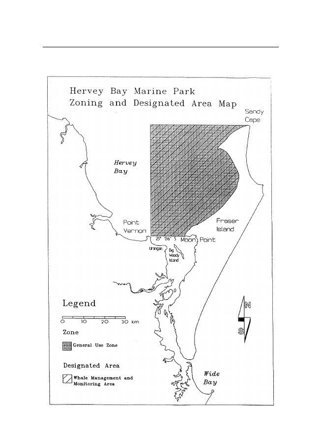
1989s32.2ZonesThiszoningplandefinesasinglezone,andassignsthefollowing name to such zone—•general use zoneThe boundaries of
the zone are described in schedule 2 to thiszoning plan. The
approximate locations of the boundaries ofthe zone are
shown on the zoning and designated area mapthat forms part
of this zoning plan.2.3Designated areaThe zoning plan
assigns the following name to the designatedarea—•whale management and monitoring
areaTheboundariesofthewhalemanagementandmonitoringareaaredescribedinschedule3tothiszoningplan.Theapproximatelocationsoftheboundariesofthewhalemanagementandmonitoringareaareshownonthezoningand designated
area map that forms part of this zoning plan.3Application of Queensland, Commonwealth
andinternational lawNothing in the
zoning plan shall—(a)beconstruedaspermittinganyactivityotherwiseprohibitedunderthelawsofQueenslandortheCommonwealth;(b)haveanyeffectcontrarytotheobligationsoftheCommonwealth Government under
international law;(c)be construed as permitting the taking
of any animal orplantprotectedunderQueenslandorCommonwealthlegislation;
and(d)beconstruedasregulating,restricting,restrainingorprohibitingtheconstructionordisplayofsignsornotices required by law.
s45s4Marine Parks (Hervey Bay) Zoning Plan
19894InterpretationIn this zoning
plan unless contrary intention appears—Actmeans
theMarine Parks Act 1982-1988.aircraftmeans a machine
or device that can derive support inthe atmosphere
from the reactions of the air or from buoyancy,but does not
include a hovercraft.alienated landmeans land
alienated from the Crown and heldin fee simple
immediately prior to gazettal of the Hervey BayMarine
Park.animalmeansanymember,aliveordead,oftheanimalkingdom (other
than man) and includes—(a)spat, spawn, eggs
and parts of eggs; and(b)the skin,
feathers, shell or other part of an animal.baitgatheringmeanstakingofyabbies,eugaries(pippies),baitwormsorcrabswhentakenbyhandorbyhand-heldimplementinaccordancewithprovisionscontainedintheFisheries Act
1976-1984and regulations made under that Act.bait
nettingmeans fishing using a cast net, scoop or dip
net,amateur bait net or a commercial bait net
described in, andused in accordance with the conditions of
use contained in,thefifthandsixthschedulesoftheFisheriesRegulations1977.bait wormsmeans worms
belonging to the Class Polychaetaand which are
taken for use as bait.collectingmeans the taking
of any declared animal, plant ormarine
product.commercial nettingmeans fishing
using any net described in,and used in accordance with the
conditions of use containedin, the fifth schedule of theFisheriesRegulations1977,
butdoes not include trawling.commercialoystergatheringmeansthetakingofoystersfromanoystergroundinaccordancewithprovisionscontainedintheFisheriesAct1976-1984andregulationsmade under that
Act.crabbingmeans the taking
of crabs by the apparatus describedin,andusedinaccordancewiththeconditionsofuse
s46s4Marine Parks (Hervey Bay) Zoning Plan
1989containedin,thefifthandsixthschedulesoftheFisheriesRegulations 1977.crabsmeans crustacea
of the Section Brachyura.declaredmeans any animal,
plant or marine product listed inschedule 4 of
this zoning plan.drop purse seine nettingmeans fishing
using a purse seine netoflengthlessthan200metresinaccordancewiththeconditionsofusecontainedinthefifthscheduleoftheFisheries
Regulation 1977.eugariemeans a mollusc
belonging to the speciesPlebidonaxdeltoides.fishingmeans the taking
of fish, crustaceans or molluscs butdoes not include
the taking of declared animals.high
watermeans the mean height of the higher tide at
springtides.highest
astronomical tidemeans the highest level of the tidesthat
can be predicted to occur under average meteorologicalconditionsandunderanycombinationofastronomicalconditions.hookmeans
a single hook or a group of hooks linked (ganged)together.hovercraftmeans any
air-cushion vehicle.limitedcollectingmeansthetakingofnotmorethan5specimens of any one species of fish,
shells or invertebrates(other than corals–Class Anthozoa)
within any 28 day period,by means of a hand-held implement or
by hand only.limitedoystergatheringmeansthegatheringofoysters(oyster
gathering) for their immediate consumption.manipulativeresearchmeansanyresearchwhichbythenatureofitsactivitieswillresultinsignificantdamage,degradationordisruptiontothephysicalenvironmentorlivingresourcesofthemarineparkandincludestakingofspecimens by fishing or collecting.marineparkmeansany marineparksetapartanddeclaredunder the
Act.
s47s4Marine Parks (Hervey Bay) Zoning Plan
1989marine plantmeans a plant
that grows below high water andincludes
eel-grass and dugong-grass.marine
products,includes oyster, pearl oyster, trochus,
greensnail, coral, coral limestone, shell-grit
and star sand; and(a)all forms of indigenous plants and
animals.(b)Aboriginalremains,artifactsorhandcraftortracesthereof.(c)wrecks, relics or traces thereof;
and(d)all other material comprising tidal
land within an areaset apart and declared as a marine
park.Ministermeans the
Minister of the Crown who at the materialtimeischargedwiththeadministrationoftheActandincludesaMinisteroftheCrownwhoistemporarilyperforming the
duties of the Minister.oystermeans a mollusc
of the Family Ostreidae and includesan oyster without
its shell.photography and filmingmeans the use of
still, video or cinecamera equipment for the recording of images
or sound.plantsincludes fungi,
seed and parts of plants.power-headmeans a device by
means of which fish may betaken, being a device that may be
attached to a spear and thatconsists of or
contains an explosive charge.public
noticemeans a notice published—(a)in the gazette; and(b)in a newspaper that circulates
throughout Queensland.regulationsmeans regulations
made under the Act.schedulemeans a schedule
to this zoning plan.shipmeans a vessel
with a gross tonnage in excess of 1500tonnes.stowed or securedmeans equipment
rendered inoperative and,in relation to trawl equipment,
rendered inoperative at least tothe extent of
having nets out of water and hung on board withcod ends
open.
s58s5.2Marine Parks
(Hervey Bay) Zoning Plan 1989takemeansinrelationtomarineproducts,remove,gather,catch,capture,kill,destroy,dredgefor,raise,carryaway,bring ashore,
land from a vessel or otherwise to remove froma natural
environment and attempt or permit any such act.trawlingmeans
fishing using any trawl described in and usedin accordance
with the conditions of use contained in, the fifthschedule of theFisheries
Regulations 1977.vesselmeans a ship,
boat, raft or pontoon or any other thingcapable of
carrying persons or goods through or on water, andincludes a hovercraft.yabbiesmeanscrustaceaoftheGenusCallianassaoftheFamily Callianassidae.Part twoZoning
provisions5General use zone5.1ObjectiveTo provide
opportunities for reasonable general-use consistentwith
the conservation of the marine park.5.2Use
and entrySubjecttopartthree(Designatedareas)andpartfour(Additional uses and exemptions) this clause
sets out the onlypurposesforwhichthegeneralusezonemaybeusedorentered—(a)unless otherwise stated in paragraph
(b)—(i)trolling;(ii)line
fishing;(iii)spearfishing
subject to the following conditions—•not
for sale or trade;
s5.29s5.2Marine Parks (Hervey Bay) Zoning Plan
1989•not with underwater breathing
apparatus (otherthan a snorkel);•not
with a power-head;•in accordance with the seventh
schedule of theFisheries Regulations 1977;(iv)limited
collecting;(v)limited oyster gathering;(vi)crabbing;(vii) bait
gathering;(viii) bait netting;(ix)commercial netting;(x)trawling;(xi)commercialpoleandlinetunafishing,includingcatching bait by drop purse seine
netting;(xii) recreationaloreducationalactivitiesthatdonotinvolvethetakingofplants,animals,ormarineproducts;(xiii) photography and filming;(xiv)
non-manipulative research;(xv)navigationandoperationofvessels,otherthanhovercraft;(xvi)
operationoftouristprogramsandanyassociateduse
of vessels;(xvii)the operation of aircraft at an
altitude of not lessthan 500 feet above ground or water;(b)with the written permission of the
chief executive—(i)manipulative research;(ii)commercial oyster gathering;(iii)collecting;(iv)the
conduct of a developmental fishery program;
s5.210s5.2Marine Parks (Hervey Bay) Zoning Plan
1989(v)thefarmingofmarineresourcesincludingtheoperation,construction,maintenance,demolitionor
removal of any associated facility;(vi)theconstruction,operation,maintenance,demolitionorremovalofanyfacilityassociatedwith
a tourist program;(vii) theconstructionorconductofmooringfacilitiesfor
vessels;(viii) the operation of a structure
including the conductof operations in or upon, the
discharge of wastesfrom,orthebuilding,assembling,fixinginposition,maintenanceordemolitionof,thatstructure;(ix) the
operation of aircraft other than as specified inparagraph (a);(x)the
navigation and operation of a hovercraft;(xi)thedumpingofspoilorthecarryingoutofreclamationworksbeachprotectionworks,extractive
industries, harbour works, road buildingworks or any
other works;(xii) programs for the taking of animals or
plants whichposeathreattohumanlifeorsafety,marineecosystemswhicharepartofthemarineparkorthe use and amenity of an area or of
adjacent areas;(xiii) •explorationforpetroleumbythe
holderofanauthoritytoprospectissuedpursuanttothePetroleum Act 1923–1986;•extraction of
petroleum by the holder of a leaseor licence issued
pursuant to thePetroleum Act1923–1986;•explorationformineralsbytheholderofanauthoritytoprospectissuedpursuanttotheMining Act 1968–1986;•mining for
minerals by the holder of a miningleaseissuedpursuanttotheMiningAct1968–1986;
s5.311s6.3Marine Parks (Hervey Bay) Zoning Plan
1989(xiv) any purpose not listed in the clause,
consistent withthe objective of the zone.5.3Prohibited useThisclausesetsoutthoseuseswhichareprohibitedinthegeneral use zone—(a)any
purpose not listed in clause 5.2 that is not consistentwith
the objectives of the zone.Part threeDesignated
areas6Whale management and monitoring
area6.1DesignationThe boundary of
the whale management and monitoring areais described in
schedule 3 to the zoning plan and is indicatedon the zoning and
designated area map.6.2ObjectiveTomanagehumanactivitiesinthevicinityofhumpbackwhales (Megaptera novaeangliae) and monitor the
effects ofsuch activities to ensure the protection of
the whales.6.3Use and entryNotwithstandingtheprovisionsofparttwo(Zoningprovisions)andsubjecttopartfour(Additionalusesandexemptions), from 1 August each year
to 30 November of thesameyear,orasdesignatedbypublicnoticebythechiefexecutive, the following conditions shall
apply—(a)thepermissioninwritingofthechiefexecutiveisrequired for—
s6.312s6.3Marine Parks (Hervey Bay) Zoning Plan
1989(i)conduct of a tourist program based on
humpbackwhales, and associated vessel use;
and(ii)conduct of a research program, and any
associatedvessel or aircraft use, or associated
activities; and(iii)commercialphotography,filmmakingorvideomaking.(b)(i)The owner or any
person in charge of a vessel shallnot cause or
permit that vessel—•toapproachwithin100metresofanyhumpback whale;•toapproachwithin300metresofanyhumpbackwhale,whentwoormoreothervessels are
within 300 metres of that whale;•to
approach a humpback whale head on;•toherd,chaseorotherwisepreventthefreemovement of
humpback whales; or•to separate a group of humpback whales
or tocome between a mother and calf.(ii)A person in charge of a vessel which
is within 300metres of any humpback whale shall—•whenmoving,manoeuvrethevesselataconstant speed of not more than 4
knots;•avoid sudden changes of
direction;•whenstopping,allowmotorstoidleforoneminute prior to turning off, and raise
outboardmotors;•when
departing from the area, idle motors for ashort time prior
to moving off at not more than4knotsuntilthevesselis300metresdistantfrom
any humpback whale; and•manoeuvre the
vessel to abandon contact with ahumpbackwhaleatanysignofahumpbackwhale becoming
disturbed or alarmed.
s6.313s6.3Marine Parks (Hervey Bay) Zoning Plan
1989(iii)Apersonshallnotfeedhumpbackwhalesordiscardrubbishintothewaterinthevicinityofhumpback whales;(iv)Apersonwhoiswithin300metresofanyhumpback whale shall not make loud
noises whichare likely to disturb that whale;(v)Apersonwhoisswimmingordivinginthevicinity of a humpback whale shall not
approachwithin 30 metres of that whale;(vi)Apersoninchargeofanaircraftshallnotmanoeuvrethataircraftlowerthan300metresabove
an area within 300 metres of any humpbackwhalePROVIDEDTHAThelicoptershallnotbeused for whale
watching purposes;except where expressly permitted by the
chief executiveforthepurposesofbonafideresearchorcommercialphotography under
(a)(ii) and (a)(iii) above.(c)Indeterminingthepoliciestoapplytotheissueofpermitsfortheconductoftouristprogramsbasedonhumpback whales, the chief executive shall
consult withan advisory committee comprising
representatives of thefollowing—(i)personsexperiencedintheconductoftouristprograms based on
whales;(ii)personshavingexpertiseintheconservationandmanagement of whales;(iii)personshavingscientificknowledgeoftheconservation
status and biology of whales and ofwhale behaviour,
and(iv)the Hervey Bay City Council.(d)The chief executive shall publicise
measures necessaryfromtimetotimefortheprotectionofhumpbackwhaleswithinthewhalemanagementandmonitoringareaandshallmakeavailableguidelinesforpersonsinvolved in whale
watching activities.
s6.414Marine Parks (Hervey Bay) Zoning Plan
1989s76.4Monitoring
requirementsThechiefexecutiveshallmonitorhumpbackwhalepopulationsinthewhalemanagementandmonitoringareaand
the effects of human activities on whale populations andbehaviour.Part fourAdditional uses andexemptions7Access in special circumstancesIn
addition to the purposes specified in part two and part
threeof this zoning plan, a zone or designated
area may be used orentered for the purpose of—(a)savinghumanlifeoravoidingtheriskofinjurytoahuman being;(b)locating or securing the safety of an
aircraft, vessel orstructure which is, or may be, endangered by
stress ofweather or by navigational or operational
hazards;(c)governmentreconnaissance,surveillance,orlawenforcement(includingenforcementoftheActandregulations);(d)monitoring of the marine park by, or with
the approvalof, the chief executive;(e)dealing with an emergency involving a
serious threat tothe environment;(f)afternotificationtothechiefexecutiveandsubjecttoanydirectionsthechiefexecutivemayimposeasarereasonablynecessaryfortheconservation,protectionandpreservationofthemarineparkandpropertyandthings in the marine park.(i)the removal of a vessel that is
wrecked, stranded,sunk or abandoned (but does not apply to a
wreckprotected under theHistoric
Shipwrecks Act 1976of the Commonwealth or to a wreck located
within
s815s8.3Marine Parks
(Hervey Bay) Zoning Plan 1989aspecialmanagementareawhichhasbeendesignated for the purpose of special
managementof that wreck);(ii)defence operations, including the use of
ships andaircraft;(iii)governmentgeodeticsurveys,governmentbathometricsurveysorsimilargovernmentsurveys;(iv)theconductandservicingofauthorizednavigational aids
and their ancillary buildings andworks,includingtheoperationofvesselsandaircraft for these purposes.Part
fiveMarine Park AdvisoryCommittee8Marine Park Advisory Committee8.1Establishment of committeeTheMinistershallestablishaHerveyBayMarineParkAdvisory Committee.8.2Functions of committeeThe functions of
the Committee are to furnish advice to theMinister and the
chief executive in respect of matters of policyrelatingtotheHerveyBayMarineParkeitherofitsownmotion or at the
request of the Minister or chief executive.8.3Membership of committeeThe committee
shall comprise a chairman nominated by theMinister,andmembersappointedbytheMinisterupontherecommendationofthechiefexecutive,whohavespecific
s8.316s8.3Marine Parks (Hervey Bay) Zoning Plan
1989knowledgeofHerveyBayandrepresentthefollowinginterests—(i)commercial fishing;(ii)recreational fishing;(iii)local
government;(iv)tourism;(v)conservation;(vi)scientific research.Members of the
committee shall hold office for such period asthe Minister may
approve. A member may resign his office bywritten
notification to the Minister.
17Marine Parks (Hervey Bay) Zoning Plan
1989Schedule 1Boundary of
Hervey Bay MarineParkThiszoningplanappliestotidallandandtidalwatersofQueensland within the outer boundary
described in this schedule,but does not include—•anyareasofnationalparksetapartanddeclaredundertheNational Parks and Wildlife Act
1975-1984;•any area of
environmental park reserved and set apart undertheLand
Act 1962-1985; and•any
areas of alienated tidal land.The outer
boundary of the Hervey Bay Marine Park—(a)commences at the point of intersection of
the parallel ofLatitude25º13.6'southbythewesterncoastlineofFraser Island at highest astronomical
tide, in the vicinityof Moon Point;(b)runs
thence west along that parallel to its intersection bythemeridianoflongitudepassingthroughtheeasternmostpointofPointVernonathighestastronomical
tide;(c)thencenorthalongthatmeridiantoitsintersectionbythe
parallel of latitude passing through the northernmostpoint
of Fraser Island at highest astronomical tide; and(d)thencegenerallysouth-westerly,south-easterly,southerlyandsouth-westerlyalongthecoastlineofFraser Island at highest astronomical tide
to the point ofcommencement.
18Marine Parks (Hervey Bay) Zoning Plan
1989Schedule 2Zone
boundaryZonegeneral use zoneBoundarytidal
land and tidal waters ofQueensland within the boundarydescribed in schedule 1 to this
zoningplan
19Marine Parks (Hervey Bay) Zoning Plan
1989Schedule 3Designated area
boundaryArea Namewhale management
andmonitoring areaBoundarytidal
land and tidal waters ofQueensland within the boundarydescribed in schedule 1 to this
zoningplan
20Marine Parks (Hervey Bay) Zoning Plan
1989Schedule 4Declared animals,
plants andmarine productsPart IAnimalsFishAll
species of each of thefollowing—Family
AcanthuridaeFamily AntennariidaeFamily
ApogonidaeFamily AulostomidaeFamily
BlennidaeFamily ChaetodontidaeFamily
ClinidaeFamily FistulariidaeFamily
GobiidaeFamily HolocentridaeFamily
OstraciontidaeFamily PegasidaeFamily
PomacentridaeFamily SynanceidaeFamily
SyngnathidaeGenus AnamapsesGenus
CirrhiticthysGenus DendrochirusGenus
EpibulusGenus GomphosusGenus
Labroides(Surgeonfish, Moorish Idols,Unicornfish)(Angelfish)(Cardinalfish,
Soldierfish)(Trumpetfish)(Combtooth
Blennies)(Butterflyfish, Coralfish, Angelfish)(Flutemouths)(Gobies,
Mud-hoppers, Gudgeons)(Squirrel-fish, Soldierfish)(Boxfish, Cowfish, Turretfish)(Dragonfish)(Damselfish,
Pullers, Sergeant-Majors,Anemonefish)(Stonefish)(Sea-horses,
Pipefish)(Scribbled Wrasse)(Hawkfish)(Dwarf Lionfish)(Sling-Jaw or
Telescopefish)(Bird Wrasse)(Cleaner
Wrasse)
21Marine Parks (Hervey Bay) Zoning Plan
1989Schedule 4 (continued)FishAll
species of each of thefollowing—Genus LoGenus
MacropharyngodonGenus ParacirrhitesGenus
PteroisGenus PteropterusGenus
StethojulisGenus ThalassomaSpeciesChoerodon fasciatusSpeciesEpinephelus lanceolatus(Fox-face)(Red-flecked Wrasse)(Butterfly Cod,
Red Firefish orLionfish)(Rainbowfish)(Moon Wrasses,
Jansen’s Wrasse)(Harlequin Tuskfish)(Groper)InvertebratesAll species of
each of thefollowing—Class Bivalvia
(except FamilyAmusidae)Class Crustacea
(except FamilyPanuliridae, Family Panaeidae,Family
Scytlaridae, speciesPortunus sanguinolentus,
males ofthe speciesPortunus
pelagicusorScylla serrata)Class
ForamininiferaClass GastropodaFamily
NautilidaePhylum BryozoaPhylum
Coelenterata(Hydroids, Jellyfish and Corals)Phylum
Echinodermata (except(Starfish, Sea Cucumbers, Seaspecies Acanthaster planci)Urchinsm Brittlestars and
Featherstars)Phylum Porifera(Sponges)
22Marine Parks (Hervey Bay) Zoning Plan
1989Schedule 4 (continued)ReptilesAll
species of each of thefollowing—Family
CheloniidaeFamily DermochelyidaeFamily
HydrophiidaeFamily Laticaudidae(Marine
Turtles)(Marine Turtles)(Sea
Snakes)(Sea Snakes)MammalsAll
species of each of thefollowing—Order
CetaceaOrder Sirenia(Whales and
Dolphins)(Dugong)Part IIPlantsall species of
plantsPart IIIMarine
productscoral limestonesea shellsshell-gritstar
sand
23Marine Parks (Hervey Bay) Zoning Plan
1989
24MarineParks(HerveyBay)ZoningPlan1989Endnotes1Index to endnotesPage2Date to which amendments incorporated
. . . . . . . . . . . . . . . . . . . . . . . . . . . . . . . .
.243Key . . . . . . . . . . . . . . . . .
. . . . . . . . . . . . . . . . . . . . . . . . . . . . . . . . . .
. . . . . . . . . . .244Table of reprints
. . . . . . . . . . . . . . . . . . . . . . . . . . . . . . . . . .
. . . . . . . . . . . . . . . . . .255List
of legislation . . . . . . . . . . . . . . . . . . . . . . . . . .
. . . . . . . . . . . . . . . . . . . . . . . . .256List of annotations . . . . . . . . .
. . . . . . . . . . . . . . . . . . . . . . . . . . . . . . . . . .
. . . . . . .252Date to which amendments
incorporatedThis is the reprint date mentioned in the
Reprints Act 1992, section 5(c). Accordingly, thisreprint includes all amendments that
commenced operation on or before 18 February2005.Future amendments of the Marine Parks
(Hervey Bay) Zoning Plan 1989 may bemade in accordance
with this reprint under the Reprints Act 1992, section 49.3KeyKey to
abbreviations in list of legislation and annotationsKeyAIAamdamdtchdefdivexpgazhdginslapnotfdo in comorigpparaprecpresprevExplanation=Acts
Interpretation Act 1954=amended=amendment=chapter=definition=division=expires/expired=gazette=heading=inserted=lapsed=notified=order
in council=omitted=original=page=paragraph=preceding=present=previousKey(prev)procprovptpubdR[X]RArelocrenumrep(retro)rvsschsdivSIASIRSLsubunnumExplanation=previously=proclamation=provision=part=published=Reprint No.[X]=Reprints Act 1992=relocated=renumbered=repealed=retrospectively=revised edition=section=schedule=subdivision=Statutory Instruments Act 1992=Statutory Instruments Regulation
2002=subordinate legislation=substituted=unnumbered
25MarineParks(HerveyBay)ZoningPlan19894Table of
reprintsReprints are issued for both future and past
effective dates.For the most up-to-date tableof
reprints, see the reprint with the latest effective date.Ifareprintnumberincludesaletterofthealphabet,thereprintwasreleasedinunauthorised, electronic form only.ReprintNo.1Amendments included2005
SL No. 12Effective18 February
2005Notes5List
of legislationMarine Parks (Hervey Bay) Zoning Plan
1989(prov zoning plan for Hervey Bay Marine Park
approved in the instrument made asan order in
council)pubd gaz 16 September 1989 p 544exp
31 August 2006 (see SIA s 56A(2) and SIR s 5 sch 3)Note—The expiry date may have changed since
this reprint was published. See thelatest reprint of
the SIR for any change.amending legislation—Marine
Parks Zoning Plans Amendment Zoning Plan (No. 1) 2005 SL No. 12 pts
1, 3notfd gaz 18 February 2005 pp 596–7commenced on date of notification6List of annotationsShort
titles 1sub 2005 SL No. 12 s 16Application of zoning plans
1Ains 2005 SL No. 12 s 16Interpretations 4def“Director”om 2005 SL No. 12
s 17Use and entrys 5.2amd
2005 SL No. 12 s 18Use and entrys 6.3amd
2005 SL No. 12 s 19Monitoring requirementss 6.4amd
2005 SL No. 12 s 20Access in special circumstancess
7amd 2005 SL No. 12 s 21