


This water plan may be cited as the Water Plan (Warrego, Paroo, Bulloo and Nebine) 2016.s 1 sub 2016 SL No. 216 s 146 sch 20
The purposes of this plan are—(a)to define the availability of water in the plan area; and(b)to provide a framework for sustainably managing the water and the taking of the water; and(c)to identify priorities and mechanisms for dealing with future water requirements; and(d)to provide a framework for establishing water allocations; and(e)to provide a framework for reversing, when practicable, degradation in natural ecosystems; and(f)to regulate the taking of overland flow water; and(g)to regulate the taking of groundwater.
The dictionary in schedule 6 defines particular words used in this plan.
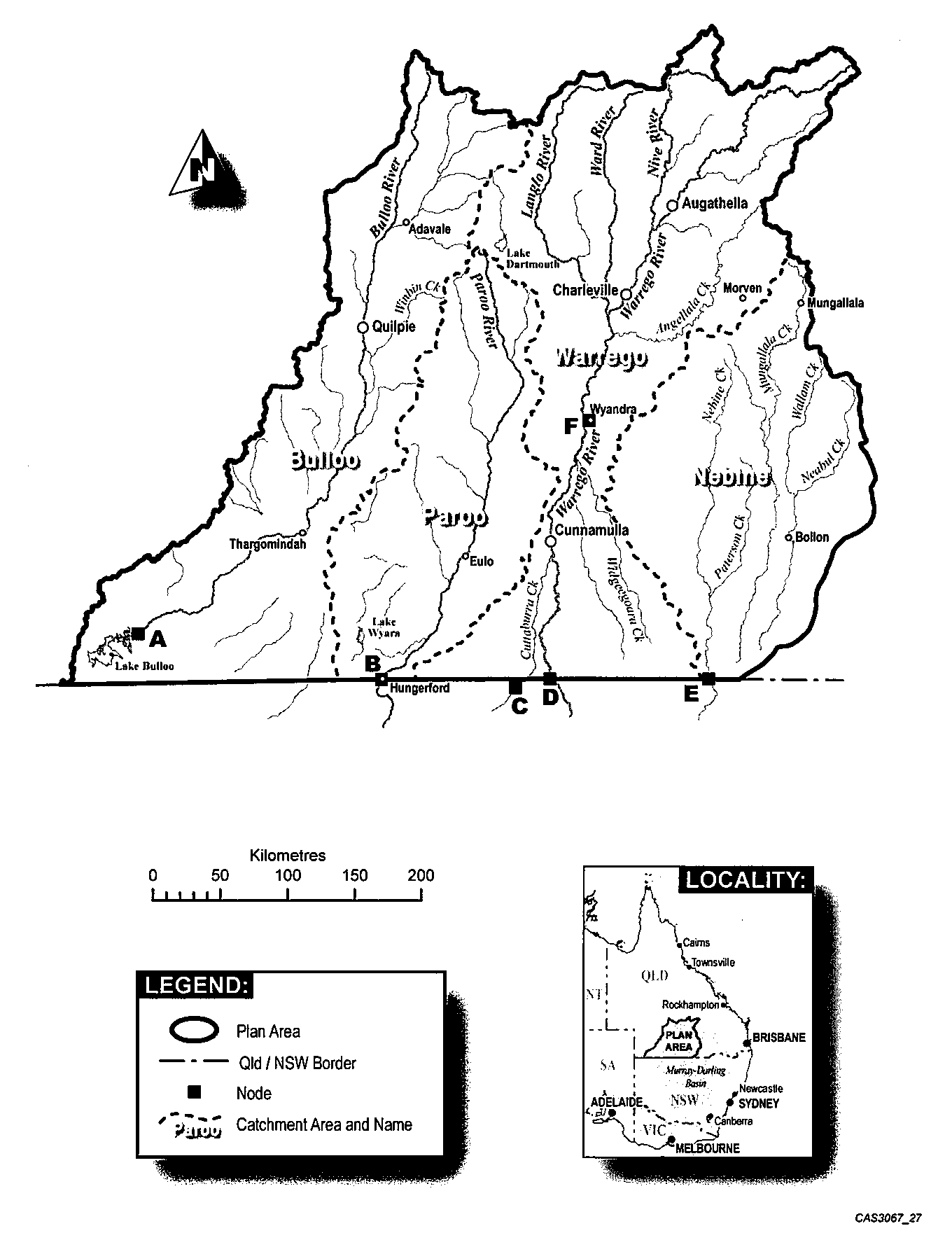
This plan applies to the area shown as the plan area on the map in schedule 1.
(1)Each part of the plan area that is shown as a catchment area on the map in schedule 1 is a catchment area.(2)A reference in this plan to a catchment area by name is a reference to the catchment area in schedule 1 with that name.
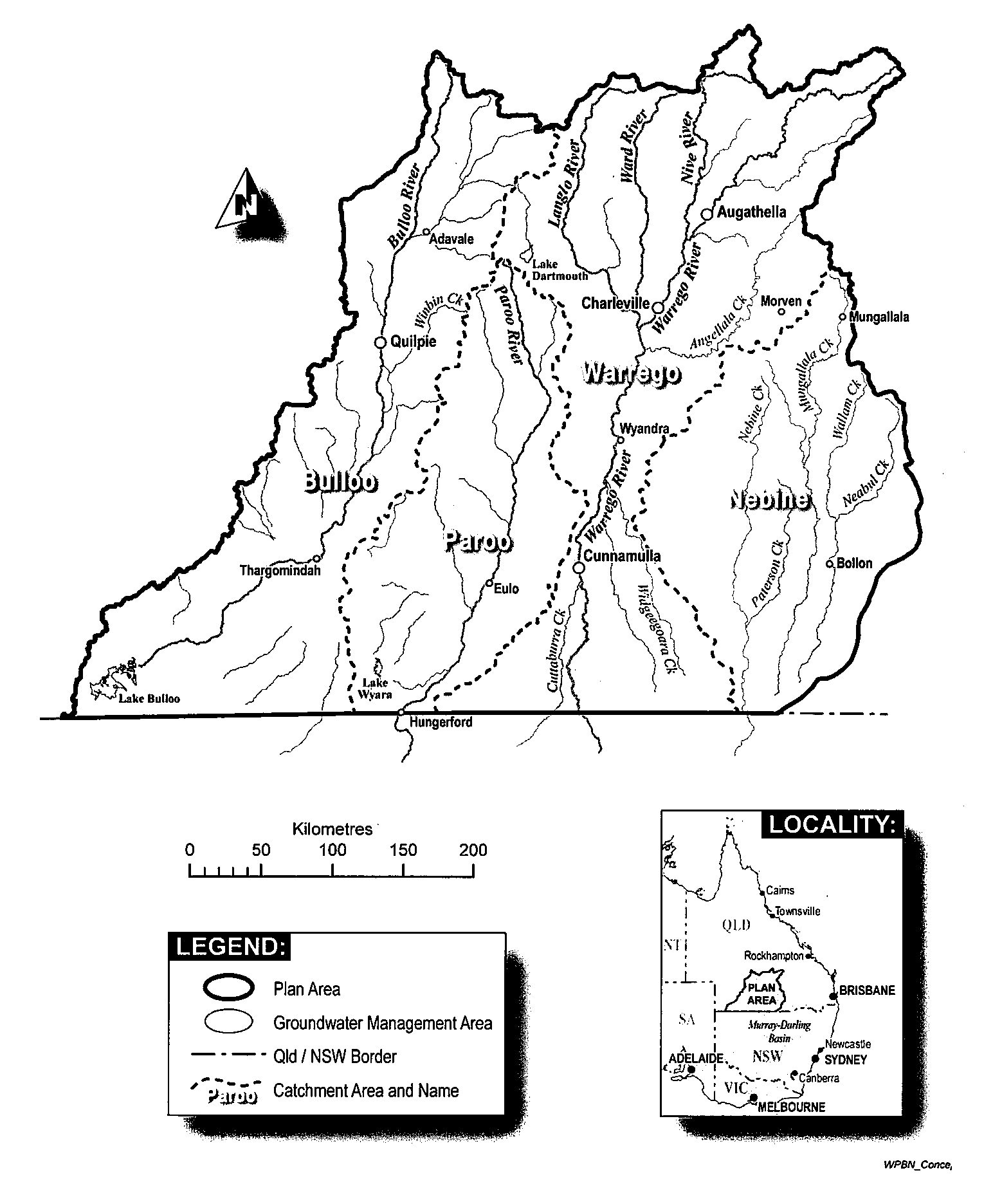
(1)The part of the plan area shown as the groundwater management area on the map in schedule 2 is the groundwater management area.(2)The groundwater management area consists of the following (each a groundwater unit)—(a)the St George alluvium (shallow);(b)the St George alluvium (deep);(c)the sediments above the Great Artesian Basin, containing the aquifers of—(i)the Winton Formation; and(ii)the Mackunda Formation; and(iii)the Allaru Mudstone; and(iv)the Griman Creek Formation; and(v)the Glendower Formation;(d)the Warrego alluvium.
The exact location of the boundaries of the plan area and catchment areas are held in digital electronic form by the department and may be accessed, free of charge, at each office of the department.The location of each office of the department is available on the department’s website.
(1)A node is a point on a watercourse in the plan area.(2)The location of each node is shown on the map in schedule 1 and described in schedule 3.(3)Each node is identified on the map by a letter.
(1)This plan applies to surface water and groundwater in the plan area.(2)Surface water is—(a)water in a watercourse or lake; or(b)water in a spring not connected to water to which the Water Plan (Great Artesian Basin and Other Regional Aquifers) 2017 applies; or(c)overland flow water, other than water in a spring connected to water to which Water Plan (Great Artesian Basin and Other Regional Aquifers) 2017 applies.(3)Groundwater is underground water to which the Water Plan (Great Artesian Basin and Other Regional Aquifers) 2017 does not apply.s 9 amd 2016 SL No. 216 s 146 sch 20; 2017 SL No. 164 s 108
10Outcomes for water in plan area
(1)This chapter states the outcomes for the sustainable management of water that this plan applies to.(2)The outcomes include the allocation and management of water in a way that—(a)recognises the natural state of watercourses, lakes, springs and aquifers has changed because of the taking of, and interfering with, water; and(b)is consistent with the relevant version of the Basin Plan; and(c)is consistent with water sharing agreements and commitments between Queensland and New South Wales; and(d)achieves a balance between—(i)the ecological outcomes in section 11; and(ii)the economic outcomes in section 12; and(iii)the Indigenous outcomes in section 13; and(iv)the social outcomes in section 14.(3)In this section—relevant version of the Basin Plan, in relation to a provision of this plan relating to the allocation and management of water, means the Basin Plan 2012 (Cwlth) as in force 2 years before the provision was given to the Minister under the Water Act 2007 (Cwlth), section 63(3).The Basin Plan 2012 (Cwlth) is made under the Water Act 2007 (Cwlth).
The ecological outcomes for water in the plan area are—(a)minimisation of changes to the natural variability of flows of water that support aquatic ecosystems; and(b)maintenance of the near natural flow regime that supports the Paroo River and Bulloo River; and(c)maintenance of floodplain vegetation and wetland systems in the plan area, including—(i)Currawinya Lakes; and(ii)Paroo Overflow Lakes; and(iii)Bulloo Lakes; and(d)maintenance of flows of water in the plan area that support—(i)waterholes, other than waterholes within the storage area of a dam; and(ii)river channels; and(iii)migratory fish.
The economic outcomes for water in the plan area are—(a)provision for the use of water entitlements and other authorisations in the plan area; and(b)protection of the probability of being able to take water under a water entitlement; and(c)protection of the productive base of groundwater; and(d)support of an effective and efficient market in water allocations; and(e)availability of water for—(i)growth in industries dependent on water resources in the plan area; and(ii)stock purposes in the plan area; and(iii)tourism in the plan area; and(f)maintenance of flood flows to support grazing activities in the plan area.
The Indigenous outcomes for water in the plan area are—(a)availability of water for traditional owners who are dependent on water resources in the plan area to achieve their economic and social aspirations; and(b)maintenance of flows of water that support water-related cultural and recreational values of the traditional owners.
The social outcomes for water in the plan area are—(a)availability of water for—(i)population growth in towns and communities dependent on water resources in the plan area; and(ii)domestic purposes in the plan area; and(b)maintenance of flows of water that support water-related aesthetic, cultural and recreational values in the plan area.
15Environmental flow objectives and performance indicators
(1)The environmental flow objectives for surface water for this plan are stated in schedule 4.(2)The performance indicators for the environmental flow objectives are stated in schedule 4.
16Performance indicators for water allocation security objectives
The performance indicators for the water allocation security objectives are—(a)for water allocations to take supplemented water—the annual supplemented water sharing index; and(b)for water allocations to take unsupplemented water—the unsupplemented performance ratio.
17Water allocation security objectives
The water allocation security objectives for a decision made by the chief executive under chapter 2 of the Act are that—(a)the annual supplemented water sharing index for a water allocation group be at least the annual supplemented water sharing index for the group immediately before the decision is made; and(b)the unsupplemented performance ratio for a water allocation group be at least 99% of what the unsupplemented performance ratio for the group was immediately before the decision is made; and(c)the unsupplemented performance ratio for a water allocation group be at least 95% of what the unsupplemented performance ratio for the group was immediately before this plan commenced.
This chapter applies to a decision made by the chief executive about the allocation or management of water in the plan area, other than a decision about a water permit.s 18 amd 2017 SL No. 103 s 170
19Decision to not increase amount of water taken
(1)This section applies to a decision, other than a decision about—(a)taking unallocated water under section 23; or(b)taking or interfering with groundwater that is not in a groundwater unit.(2)The chief executive must not make a decision that would increase—(a)the average volume of water that may be taken under this plan; or(b)the total nominal entitlement for taking groundwater under this plan.
20Decisions to be consistent with objectives
A decision made by the chief executive under chapter 2 of the Act must be consistent with—(a)the environmental flow objectives stated in schedule 4; and(b)the water allocation security objectives stated in section 17.
21Assessing impact of decisions
(1)To assess consistency with the environmental flow objectives and the water allocation security objectives, the model computer program’s simulation for the simulation period must be used.(2)If it is not practicable to use the model computer program, another kind of assessment, approved by the chief executive, may be used.
22Purpose for which unallocated water may be granted
The chief executive may grant a water entitlement to take unallocated water in the plan area for—(a)a community purpose; or(b)an Indigenous purpose; or(c)any purpose, if the unallocated water is in—(i)the Bulloo catchment area; or(ii)a groundwater unit.
(1)The total of the average annual volume for water entitlements to take unallocated water in the plan area is stated in—(a)for water entitlements to take unallocated water for a community purpose or Indigenous purpose from a catchment area in schedule 5, table 1, column 1—column 2 of the table; or(b)for water entitlements to take unallocated water from the Bulloo catchment area in schedule 5, table 2, column 1—column 2 of the table.(2)The total of the nominal entitlement for water licences to take unallocated water from a groundwater unit in schedule 5, table 3, column 1 is stated in column 2 of the table.
24Process for granting unallocated water
The process for granting unallocated water in the plan area is the process stated in the Water Regulation.
25Limitation on taking or interfering with water—Act, s 20(2)
The total volume of water that may be taken or interfered with for an activity prescribed for section 20(2)(a) of the Act is—(a)for water taken from part of a watercourse in the plan area that is used to distribute water by a resource operations licence holder—0ML; and(b)for water taken from anywhere else in the plan area—2ML.
26Limitation on taking overland flow water—Act, s 20(2)(b)
A person may take overland flow water in the plan area—(a)under a water licence; or(b)for stock or domestic purposes; or(c)for prescribed activities for general authorisations to take water under the Water Regulation; or(d)to comply with an environmental authority, if the person takes no more than the volume of water necessary to comply with the authority; or(e)to comply with a development permit for carrying out an environmentally relevant activity, other than a mining or petroleum activity, under the Environmental Protection Act, if the person takes no more than the volume of water necessary to comply with the authority; or(f)if the water contains, or is likely to contain, excess nutrients or farm chemicals at levels that are harmful or potentially harmful to the quality of water in a watercourse; or(g)if the works that are used to take the water are existing overland flow works.
27Water licence to take overland flow water
A water licence to take overland flow water must state—(a)the purpose for which the water may be taken as ‘any’; and(b)at least 1 of the following—(i)the maximum rate at which the water may be taken;(ii)the maximum volume of the water that may be stored;(iii)the volumetric limit for the water;(iv)the average annual volume for the water; and(c)the conditions (if any) that the licence is subject to.
s 28 om 2016 SL No. 216 s 146 sch 20
29Limitation on taking or interfering with groundwater—Act, s 20(2)(c)
(1)A person may take or interfere with groundwater in a groundwater unit only—(a)under a water licence or water permit; or(b)for stock or domestic purposes; or(c)for an activity prescribed for section 20(2)(a) of the Act.(2)However, a person must not take or interfere with groundwater under subsection (1)(c) from the St George Alluvium (deep).
s 30 om 2016 SL No. 216 s 146 sch 20
ch 6 hdg amd 2016 SL No. 216 s 146 sch 20
The monitoring requirements for water and natural ecosystems for this plan are stated in the resource operations plan for this plan.
s 32 om 2016 SL No. 216 s 146 sch 20
33Minor or stated amendment of plan—Act, s 57(b)
The following types of amendment may be made to this plan—(a)an amendment or addition of a performance indicator or environmental flow objective if the amendment or addition achieves an equivalent or improved ecological outcome without adversely affecting—(i)the outcomes in chapter 3; or(ii)the water allocation security objectives in section 17;(b)an amendment or addition of a water allocation security objective if the amendment or addition does not adversely affect—(i)the outcomes in chapter 3; or(ii)the environmental flow objectives in section 15;(c)an amendment or addition of a node location;(d)an amendment to adjust the boundaries of a catchment area, a groundwater unit or the plan area if more accurate information about the boundaries of the plan area or hydrological characteristics of the plan area becomes available;(e)an amendment or addition of a monitoring or reporting requirement under chapter 6.
The Water Resource (Warrego, Paroo, Bulloo and Nebine) Plan 2003, SL No. 317 is repealed.
35Existing applications for authorisations to take water
Section 19 applies to a decision about an application for an authorisation to take water that was made, but not decided, before this plan commenced.
36Existing overland flow works authorisations
(1)The chief executive may grant a water licence under section 212 of the Act to a person who, immediately before this plan commenced, was allowed to use existing overland flow works.(2)When deciding what must be stated on the licence under section 27(b), the chief executive—(a)must consider—(i)the average annual volume of water that, immediately before this plan commenced, the person was allowed to take using the existing overland flow works; and(ii)the annual volumes of water that the chief executive estimates were taken using the existing overland flow works in the period, of not more than 10 years, immediately before this plan commenced; and(b)may consider the extent to which, immediately before this plan commenced, the person was allowed to take or store other water using the existing overland flow works.
sections 4, 5 and 8
Column 1 | Column 2 |
Node | Location |
A | Bulloo River at the inflow to Lake Bulloo |
B | Paroo River at the border of Queensland and New South Wales |
C | Cuttaburra Creek at Turra |
D | Warrego River at the border of Queensland and New South Wales |
E | Nebine Creek at the border of Queensland and New South Wales |
F | Warrego River at Wyandra |
(1)At each node stated in the following table, the mean annual flow during the simulation period must be at least the percentage, of the pre-development flow, that is stated for the node.(2)In this section—pre-development flow means the mean annual flow, during the simulation period, simulated as if—(a)there were no dams or other water infrastructure in the plan area; and(b)no water had been taken under authorisations in the plan area.
Node
Environmental flow objective
A
99%
B
99%
C
93%
D
87%
E
87%
2Days in no-flow waterhole flow periods
(1)At each node stated in the following table, the total number of days in all no-flow periods must be no more than the percentage, of the total number of days in the simulation period, that is stated for the node.(2)In this section—no-flow period means a continuous period of more than 1.5 years, during the simulation period, in which daily water flows at the node are no more than 2ML.
Node
Environmental flow objective
D
0%
E
0%
F
0%
(1)At node D, the total number of days in all low flow periods must be no more than 4.9% of the total number of days in the simulation period.(2)In this section—low flow period means a continuous period of at least 1 year, during the simulation period, in which daily water flows at the node are no more than 86ML.
4Days between fish migration flow events
(1)At node D, the total number of days between fish migration flow events during the simulation period must be no more than 2,190.(2)In this section—fish migration flow event means a continuous period of 8 or more days, between 1 September of a year and 31 March of the next year, during the simulation period—(a)starting when the daily water flow at the node is more than 968ML; and(b)ending when the daily water flow at the node falls below 842ML.
(1)At each node stated in the following table, the total number of days with a river-forming flow must be at least the percentage, of the total number of days in the simulation period, that is stated for the node.(2)In this section—river-forming flow means a daily water flow at the node that is not less than a daily flow at the node that has a 50% probability of being reached at least once a year.
Node
Environmental flow objective
D
1.2%
E
1.9%
F
1.3%
6Days between floodplain inundation periods
(1)At each node stated in the following table, the total number of days in all floodplain inundation periods must be no more than the percentage, of the total number of days in the simulation period, that is stated for the node.(2)In this section—floodplain inundation flow means a daily water flow at the node that has a 20% probability of being reached at least once a year.floodplain inundation flow period means a continuous period of more than 4 years, during the simulation period, in which daily water flows at the node are no more than the floodplain inundation flow.
Node
Environmental flow objective
D
80.3%
E
86.6%
Table 1
Column 1 | Column 2 |
Catchment area | Average annual volume for unallocated water for community or Indigenous purposes |
Bulloo River catchment | 100ML |
Nebine River catchment | 100ML |
Paroo River catchment | 100ML |
Warrego River catchment | 100ML |
Table 2
Column 1 | Column 2 |
Catchment area | Average annual volume for unallocated water for any purpose |
Bulloo River catchment | 500ML |
Table 3
Column 1 | Column 2 |
Groundwater unit | Nominal entitlementvolume forunallocated water forany purpose |
sediments above the Great Artesian Basin | 8,000ML |
Warrego alluvium | 2,000ML |
annual supplemented water sharing index, for water allocations to take supplemented water, means the percentage of years in the simulation period in which the allocations are fully supplied.
average annual volume means a volume of water expressed as a long-term modelled average over the simulation period.
average volume, of water allowed to be taken under all authorisations under this plan, means the total volume of water simulated to have been taken under the authorisation in the simulation period if the authorisation were in existence for all of the simulation period, divided by the number of years in the simulation period.
catchment area see section 5.
community purpose means the purpose of—
(a)town water supply; or
(b)supporting ecotourism.
environmental authority see the Environmental Protection Act.
Environmental Protection Act means the Environmental Protection Act 1994.
existing overland flow works means overland flow works for which a notice was given, for a purpose other than stock or domestic purposes, under section 34 of the Water Resource (Warrego, Paroo, Bulloo and Nebine) Plan 2003.
groundwater see section 9(3).
groundwater management area see section 6.
groundwater unit see section 6.
Indigenous purpose means a use for the purpose of helping an Indigenous community achieve its economic and social aspirations.
mean annual flow, for a node, means the total volume of flow of water, at the node, in the simulation period divided by the number of years in the simulation period.
model computer program means—
(a)the Integrated Quantity and Quality Model computer program that simulates daily stream flows, flow management, storages, releases, instream infrastructure, water diversions, water demands and other hydrologic events in the plan area; and
(b)the statistical analysis and reporting programs associated with the computer program.
node means a node under section 8.
nominal entitlement see the Water Regulation, section 28.
sch 6 def nominal entitlement amd 2016 SL No. 216 s 146 sch 20
overland flow works means works for taking overland flow water in the plan area, including—
(a)storages, sumps, drains, embankments, channels and pumps for taking, or that can be used for taking, overland flow water; and
(b)storages that are connected to the works; and
(c)works that connect, or that can be used to connect, the storages.
Planning Act ...
sch 6 def Planning Act om 2017 SL No. 103 s 173
Planning Regulation ...
sch 6 def Planning Regulation om 2017 SL No. 103 s 173
simulated means simulated by the chief executive using the model computer program.
simulation period means the period from 1 January 1889 to 30 June 2011.
surface water see section 9(2).
traditional owners means the Aboriginal people who identify as descendants of the original inhabitants of the plan area.
unallocated water means water available for allocation in the plan area.
unsupplemented performance ratio, for a water allocation group, means the average annual volume of water that may be taken by the group in the simulation period expressed as a percentage of the total of the nominal volumes for the allocations in the group.
unsupplemented water means water that is not supplemented water.
volumetric limit, for a water entitlement, has the same meaning as volumetric limit has in section 120B of the Act for a water allocation.
water allocation group means—
(a)for taking supplemented water—the water allocations in a priority group in a water supply scheme; and
(b)for taking unsupplemented water—the water allocations in a part of the plan area stated in the resource operations plan.
Water Regulation means the Water Regulation 2016.
sch 6 def Water Regulation amd 2016 SL No. 216 s 146 sch 20