


This water plan may be cited as the Water Plan (Mary Basin) 2006.s 1 sub 2014 Act No. 64 s 255 sch 2
The purposes of this plan are—(a)for both surface and subartesian water, the following—(i)to define the availability of water in the plan area;(ii)to provide a framework for sustainably managing water and the taking of water;(iii)to identify priorities and mechanisms for dealing with future water requirements;(iv)to provide a framework for reversing, where practicable, degradation that has occurred in natural ecosystems; and(b)for surface water only—to provide a framework for establishing water allocations.
The dictionary in schedule 12 defines particular words used in this plan.
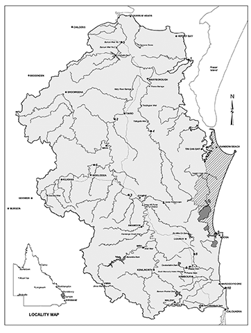
This plan applies to the area shown as the plan area on the map in schedule 1.
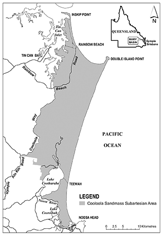
5Cooloola Sandmass subartesian area
The Cooloola Sandmass subartesian area shown on the map in schedule 2 is a subartesian area for this plan.
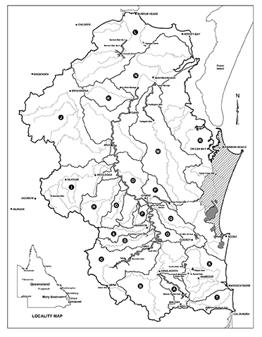
Each part of the plan area that is within a subcatchment area shown on the map in schedule 3, and named in schedule 4, is a subcatchment area for this plan.
(1)The exact location of the plan area, subartesian area and subcatchment area boundaries is held in digital electronic form by the department.(2)The information held in digital electronic form can be reduced or enlarged to show the details of the boundaries.
(1)A node mentioned in this plan is a place—(a)on a watercourse in the plan area; and(b)for which environmental flow objectives are set for performance indicators.(2)The location of each node is shown on the map in schedule 1 and described in schedule 5.(3)Each node is identified on the map by a number.
(1)This plan applies to the following water in the plan area—(a)surface water;(b)subartesian water in the Cooloola Sandmass subartesian area.(2)In subsection (1)—surface water means the following—(a)water in a watercourse or lake;(b)water in springs not connected to—(i)artesian water; or(ii)subartesian water connected to artesian water.
10Outcomes for water in the plan area
Water in the plan area is to be allocated and sustainably managed in a way that—(a)recognises the natural state of watercourses, lakes and springs has changed because of water infrastructure, flow supplementation and the taking of water; and(b)seeks to achieve a balance in the following outcomes—(i)the general outcomes mentioned in sections 11 and 12;(ii)the ecological outcomes for particular parts of the plan area mentioned in section 13.
11General outcomes for surface water in the plan area
Each of the following is a general outcome for surface water in the plan area—(a)to provide for future water requirements, including the opportunity for additional water to be taken;(b)to provide for the continued use of all water entitlements and other authorisations;(c)to protect the probability of being able to obtain water under a water allocation;(d)to provide options for water users to take action to ensure their own security of supply;(e)to encourage the efficient use of water;(f)to ensure water supply for essential services;(g)to support natural ecosystems by minimising changes to natural flow regimes;(h)to maintain, as far as practicable, surface water and groundwater interactions;(i)to ensure a reliable and secure supply of water from the plan area during the time this plan is in force;(j)to allow cultural use of the plan area by the traditional owners of the area;(k)to provide consistency with the SEQ regional plan.
12General outcomes for subartesian water in the Cooloola Sandmass subartesian area
(1)Each of the following is a general outcome for subartesian water in the Cooloola Sandmass subartesian area—(a)to encourage the efficient use of water;(b)to maintain long-term water quality;(c)to prevent seawater intrusion of the Cooloola Sandmass aquifer;(d)to maintain subartesian water discharge to support wetlands and other groundwater-dependent ecosystems;(e)to ensure reliable and secure water entitlements during the time this plan is in force;(f)to allow cultural use of the plan area by the traditional owners of the area.(2)In subsection (1)—subartesian water discharge means the part of surface water that comes from subartesian water seeping into watercourses, lakes, springs or wetlands.
13Ecological outcomes for particular parts of the plan area
Each of the following is an ecological outcome for water in a particular part of the plan area—(a)for the Noosa River, Mooloolah River and coastal streams north of Noosa River mouth—(i)to minimise changes to river-forming processes; and(ii)to minimise changes to a near-natural flow regime;(b)for the Mary River, upstream of the Mary River barrage pondage—(i)to minimise changes to the low flow regime of the river; and(ii)to minimise changes to the hydraulic habitat requirements of species such as the Mary River cod, the Mary River turtle and lungfish;(c)for Six Mile Creek—(i)to minimise changes to the low flow regime of the creek; and(ii)to minimise changes to the hydraulic habitat requirements of species such as the Mary River cod and lungfish;(d)for Tinana Creek, upstream of Tallegalla Weir—to minimise changes to the hydraulic habitat requirements of existing ecological assets in the area;(e)for Obi Obi Creek, in the Obi Obi Creek Gorge area—to minimise changes to the hydraulic habitat requirements of existing ecological assets in the area;(f)for the Burrum River—(i)in the Upper Burrum River above Lenthalls Dam—to minimise changes to the flooding regime at Wongi Waterholes; and(ii)in the Lower Burrum River system below Lenthalls Dam—to minimise changes to variability in the low flow regime of the river system to improve opportunities for fish passage.
14Application of pt 4
This part applies only to surface water.
15Performance indicators for environmental flow objectives
The performance indicators for the environmental flow objectives are—(a)for assessing periods of low flow, the following—(i)daily flow less than 1ML;(ii)50% daily flow;(iii)90% daily flow;(iv)low flow duration (10cm above cease-to-flow);(v)low flow duration (30cm above cease-to-flow);(vi)number of periods of no flow of at least 1 month but less than 3 months;(vii)number of periods of no flow of at least 3 months but less than 6 months;(viii)number of periods of no flow of at least 6 months but less than 9 months;(ix)number of periods of no flow of at least 9 months; and(b)for assessing periods of medium to high flow, the following—(i)mean annual flow;(ii)1.5 year daily flow volume;(iii)5 year daily flow volume;(iv)20 year daily flow volume; and(c)for assessing seasonal flow patterns—(i)annual proportional flow deviation; and(ii)flow regime class.
16Environmental flow objectives
The environmental flow objectives for this plan are stated in schedule 6.
17Performance indicators for water allocation security objectives
The performance indicators for the water allocation security objectives are—(a)for taking supplemented water in a water supply scheme—monthly supplemented water sharing index; and(b)for taking unsupplemented water in a subcatchment area for town water supply purposes—(i)mean unsupplemented water sharing index; and(ii)95% unsupplemented water sharing index; and(c)for taking unsupplemented water in a subcatchment area for any other purpose—mean unsupplemented water sharing index.
18Water allocation security objectives
The water allocation security objectives for this plan are stated in schedule 7.
19Strategies for surface water
This part—(a)applies only to surface water; and(b)states the strategies for achieving the outcomes mentioned in part 3.
20Application of div 2
This division applies to decisions about the allocation or management of water in the plan area, other than a decision—(a)about reinstating or replacing an expired water licence; or(b)to grant a water entitlement to a local government, government agency or the water grid manager for supply under operations that were in existence on the commencement of this plan.s 20 amd 2008 Act No. 34 s 751 sch 2
21Decisions consistent with objectives
Decisions about the allocation or management of water in the plan area, other than a decision about a water permit, must be consistent with—(a)the environmental flow objectives stated in schedule 6; and(b)the water allocation security objectives stated in schedule 7.
22Assessing impact of decisions
(1)The IQQM computer program’s simulation for the simulation period is used to assess consistency with the objectives.(2)If it is not practicable to use the IQQM computer program, another assessment method approved by the chief executive may be used.(3)The chief executive may approve an assessment method for subsection (2) only if the chief executive is satisfied the method will assess consistency with the objectives at least as accurately as the IQQM computer program.
23Decisions not to increase amount of water taken
(1)The chief executive must not make a decision that would increase the average volume of water available to be taken in the plan area.(2)Subsection (1) does not apply to—(a)a decision about unallocated water made under section 26; or(b)a decision about a water permit.(3)A decision mentioned in subsection (1) includes a decision about an application, in relation to taking water under an authorisation, made but not dealt with before the commencement of this plan.
24Restriction on taking water from waterholes or lakes
(1)The chief executive may grant a water licence, water permit or water allocation to take water from a waterhole or lake only if—(a)the chief executive imposes a condition on the licence, permit or allocation about maintaining the cultural or environmental values of the waterhole or lake; or(b)the chief executive is satisfied the taking of the water will not adversely affect the cultural and environmental values of the waterhole or lake.a condition that the water may be taken only if the water level in the waterhole or lake is above the level that is 0.5m below the level at which the waterhole or lake naturally overflows(2)In making a decision under subsection (1), the chief executive must consider—(a)the impact the proposed taking of the water may have on the following—(i)water quality;(ii)inundation of habitats;(iii)the movement of fish and other aquatic species;(iv)the natural movement of sediment;(v)recreation and aesthetic values;(vi)cultural values including, for example, cultural values of the traditional owners of the area; and(b)whether the proposed taking is likely to have a direct adverse effect on groundwater flows.(3)A water allocation mentioned in subsection (1) does not include a water allocation converted from an authorisation under division 7.(4)Subsection (1) does not limit the restrictions that may be imposed on the taking of water from a waterhole or lake.(5)Subsection (2) does not limit the matters the chief executive may consider.
25Unallocated water held as general, strategic or town water supply reserve
Unallocated water is held as a general, strategic or town water supply reserve and dealt with under this division.
Unallocated water may be granted from the general, strategic or town water supply reserve under a process in the resource operations plan.
27Matters chief executive must consider
(1)In dealing with unallocated water, the chief executive must consider—(a)the need for, and efficiency of, present and proposed uses of water including—(i)the extent to which water is being taken under current authorisations; and(ii)emerging requirements for additional water and the likely timeframe in which the additional water will be required; and(iii)alternative water sources including, for example, recycled water and water savings from improvements in the efficiency of water use; and(b)the availability of an alternative water supply for the purpose for which the water is required; and(c)the impact the proposed taking of, or interfering with, the water may have on the following—(i)water quality;(ii)inundation of habitats;(iii)the movement of fish and other aquatic species;(iv)the natural movement of sediment;(v)recreation and aesthetic values;(vi)cultural values, including, for example, cultural values of the traditional owners of the area; and(d)whether the proposed taking of, or interfering with, or the proposed use of, water is likely to—(i)have a direct adverse effect on groundwater; or(ii)lead to degradation, including salinity, of land or downstream watercourses; and(e)if the process in the resource operations plan for granting unallocated water includes a public auction, public ballot or public tender—the price offered under the process.(2)Subsection (1) does not limit the matters the chief executive may consider.
28Application of sdiv 2
This subdivision applies to unallocated water that is held as a general reserve.
29Granting unallocated water from the general reserve
(1)Unallocated water may be granted from the general reserve under a water allocation to take unsupplemented water.(2)The total of the nominal volumes for the water allocations granted for each of the following subcatchment areas must not be more than the volume stated—(a)for subcatchment area F (Pie and Calico creeks)—420ML;(b)for subcatchment area H (Widgee Creek)—420ML;(c)for subcatchment area I (Wide Bay Creek)—380ML;(d)for subcatchment area K (Myrtle Creek)—340ML;(e)for subcatchment area M (Tinana Creek)—450ML.(3)Each water allocation must state, for the allocation, the following—(a)the nominal volume;(b)the location from which water may be taken under the allocation;(c)the purpose for which the water may be taken which must be ‘any’;(d)the flow conditions under which the water may be taken;(e)the maximum rate at which the water may be taken;(f)the annual volumetric limit.(4)The flow conditions stated, for a water allocation, must provide for the protection of low flows in the watercourse.
30Application of sdiv 3
This subdivision applies to unallocated water that is held as a strategic reserve.
31Limitation on volume of unallocated water granted
Not more than 150,000ML of unallocated water may be granted from the strategic reserve in any period of 12 months.
32Granting unallocated water from the strategic reserve
Unallocated water may be granted or reserved from the strategic reserve only—(a)under a water licence for a project declared under the State Development and Public Works Organisation Act 1971, section 26, to be a significant project; or(b)for infrastructure identified in—(i)the SEQ regional plan or instruments that implement the plan; or(ii)a regional water security program.
33Application of sdiv 4
This subdivision applies to unallocated water that is held as a town water supply reserve.
34Granting unallocated water from the town water supply reserve under water licences
Unallocated water may be granted from the town water supply reserve under the following—(a)a water licence for the water grid manager to take an annual volumetric limit of up to 1,500ML from Six Mile Creek;(b)a water licence for the water grid manager to take an annual volumetric limit of up to 130ML from the Mary River;(c)a water licence for the water grid manager to take an annual volumetric limit of up to 85ML from Obi Obi Creek.s 34 amd 2008 Act No. 34s 751sch 2
35Granting unallocated water from the town water supply reserve for Wide Bay Water Corporation
(1)Unallocated water may be granted from the town water supply reserve under a water entitlement for Wide Bay Water Corporation (the Corporation) to take an annual volumetric limit of up to 3,080ML from the Burrum River, if the chief executive is satisfied—(a)construction of the alterations to Lenthalls Dam, identified in the Corporation’s interim resource operations licence for the Wide Bay Water Supply Scheme, is substantially complete and the infrastructure, as altered, may be regarded as operational; and(b)the operation of the infrastructure, as altered, is or will be consistent with the objectives of this plan; and(c)the Corporation has complied with the conditions of the licence in relation to the infrastructure.(2)The unallocated water that may be granted under subsection (1) is in addition to the 6,300ML of interim water allocation—(a)identified in the Corporation’s interim resource operations licence for the Wide Bay Water Supply Scheme; and(b)to be granted to the Corporation on substantial completion of the alterations to Lenthalls Dam.(3)In this section—alterations, to Lenthalls Dam, mean the raising of the dam wall by 2 metres.
36Process for Act, ss 176 and 184A
(1)This division—(a)states a process for granting or amending an interim resource operations licence to meet future water requirements; and(b)applies only to the granting or amendment of an interim resource operations licence for infrastructure identified in either of the following, for which unallocated water is granted or reserved from the strategic reserve—(i)the SEQ regional plan or instruments that implement the plan;(ii)a regional water security program.(2)This division applies only until it is replaced by a process stated in the resource operations plan.
37Applying for, or to amend, interim resource operations licence
(1)This section applies to the proposed owner of infrastructure identified in either of the following—(a)the SEQ regional plan or instruments that implement the plan;(b)a regional water security program.(2)The chief executive may give notice to the proposed owner that the proposed owner may apply to the chief executive for—(a)an interim resource operations licence to operate the infrastructure; or(b)an amendment of an interim resource operations licence, already held by the proposed owner, to operate the infrastructure.(3)The application must—(a)be in the approved form; and(b)include the following—(i)details of the proposed infrastructure;(ii)an assessment of the impact of constructing the infrastructure on—(A)the supply of water managed under the interim resource operations licences for the water supply schemes; and(B)existing water licences to take water from the areas of the water supply schemes; and(C)the operating arrangements and supply requirements under the interim resource operations licences for the water supply schemes; and(D)other existing authorisations, other than water permits, that may be affected by the proposed infrastructure; and(iii)the applicant’s proposal for minimising the impact assessed and mentioned in subparagraph (ii);(iv)proposed operating arrangements for the infrastructure;(v)the entities to whom the applicant proposes to supply water;(vi)the applicant’s proposal about the total interim water allocation to be managed under the proposed interim resource operations licence or proposed amended interim resource operations licence;(vii)any other information the applicant considers will enable the chief executive to decide the application; and(c)be accompanied by the prescribed fee.(4)The chief executive may give a copy of the application to any entity the chief executive considers appropriate.(5)In this section—water supply schemes means—(a)the Mary River Water Supply Scheme; and(b)the Wide Bay Water Supply Scheme; and(c)the Baroon Pocket Water Supply Scheme; and(d)the Teddington Weir Water Supply Scheme.s 37 amd 2007 SL No. 343s 3
38Additional information may be required
(1)The chief executive may, by notice, require—(a)the applicant to give additional information about the application; or(b)any information included in the application, or any additional information required under paragraph (a), to be verified by statutory declaration.(2)If the applicant does not comply with the requirement within the reasonable time stated in the notice, the application lapses.
39Matters chief executive must consider
(1)For deciding the application, the chief executive must consider—(a)the application and any additional information given about the application; and(b)the public interest.(2)Subsection (1) does not limit the matters the chief executive may consider.
40Deciding application for, or to amend, interim resource operations licence
(1)If the chief executive is satisfied the application should be approved, or approved in part, the chief executive must approve all or part of the application, with or without conditions.(2)If the chief executive grants or amends the interim resource operations licence, the chief executive must reserve, from the strategic reserve, unallocated water required for any proposed interim water allocations to which the approval applies.
41Amending interim resource operations licence by chief executive—Act, s 184A
(1)The chief executive may, at any time—(a)amend an interim resource operations licence, granted or amended under section 40, to the extent the chief executive considers necessary to meet future water requirements; or(b)amend any other interim resource operations licence, to the extent the chief executive considers necessary as a consequence of—(i)the granting or amendment of an interim resource operations licence under section 40; or(ii)the amendment of an interim resource operations licence under section 47.(2)Before the chief executive acts under subsection (1), the chief executive must give the interim resource operations licence holder notice of the proposed amendment.(3)The notice must—(a)state the following—(i)a summary of the proposed amendment;(ii)the reasons for the proposed amendment;(iii)that written submissions may be made by the holder about the proposed amendment;(iv)the day by which, the person to whom, and the place where, the submissions must be made; and(b)include a copy of the proposed amendment.(4)The day stated must be at least 30 business days after the day the notice is given.
42Matters chief executive must consider
(1)In deciding whether to amend an interim resource operations licence, the chief executive must consider—(a)the following—(i)for an amendment mentioned in section 41(1)(a)—the original application under section 37 for, or to amend, the licence and any additional information given about the application;(ii)for an amendment mentioned in section 41(1)(b)(i) as a consequence of the granting or amendment of an interim resource operations licence under section 40—the original application under section 37 for the granting or amendment and any additional information given about the application;(iii)for an amendment mentioned in section 41(1)(b)(ii) as a consequence of the amendment of an interim resource operations licence under section 47—the original application under section 44 for the amendment and any additional information given about the application; and(b)any submissions made by the interim resource operations licence holder about the proposed amendment; and(c)the public interest.(2)Subsection (1) does not limit the matters the chief executive may consider.
43Deciding whether to amend interim resource operations licence
After considering the matters mentioned in section 42 and any other matters the chief executive considers appropriate, the chief executive may amend the interim resource operations licence to the extent the chief executive considers appropriate.
44Amending interim resource operations licence on application by holder—Act, s 184A
(1)The holder of an interim resource operations licence, granted or amended under section 40, may apply to the chief executive to amend the licence.(2)The application must—(a)be in the approved form; and(b)include a summary of the amendment required and the reasons for the amendment; and(c)be accompanied by the prescribed fee.(3)The chief executive may give a copy of the application to any entity the chief executive considers appropriate.
45Additional information may be required
(1)The chief executive may, by notice, require—(a)the applicant to give additional information about the application; or(b)any information included in the application, or any additional information required under paragraph (a), to be verified by statutory declaration.(2)If the applicant does not comply with the requirement within the reasonable time stated in the notice, the application lapses.
46Matters chief executive must consider
(1)In deciding the application, the chief executive must consider—(a)the application and any additional information given about the application; and(b)the public interest.(2)Subsection (1) does not limit the matters the chief executive may consider.
47Deciding application to amend interim resource operations licence
If the chief executive is satisfied the application should be approved, or approved in part, the chief executive must approve all or part of the application, with or without conditions.
48Granting interim water allocations—Act, s 189
(1)This section applies if, at the time an interim resource operations licence is amended under section 40, 43 or 47, the chief executive is satisfied—(a)construction of the infrastructure to which the interim resource operations licence relates is substantially complete and the infrastructure may be regarded as operational; and(b)the operation of the infrastructure is, or will be, consistent with the objectives of this plan; and(c)the interim resource operations licence holder has complied with the conditions of the licence in relation to the infrastructure.(2)The chief executive may require the interim resource operations licence holder to give the chief executive the following information—(a)the number of interim water allocations to which the interim resource operations licence is to relate;(b)the volume of water that may be taken under each allocation;(c)the purpose for which the water may be taken;(d)the priority group to which each allocation is to belong;(e)the water sharing rules that are to apply.(3)After considering the information mentioned in subsection (2), the chief executive may grant the interim water allocations to which the interim resource operations licence relates.(4)This section does not apply to the amendment of another interim resource operations licence under section 43 as a consequence of—(a)the granting or amendment of an interim resource operations licence under section 40; or(b)the amendment of an interim resource operations licence under section 47.
pt 5 div 5 hdg sub 2014 SL No. 142s 148
s 49 amd 2007 SL No. 343 s 4
om 2014 SL No. 142 s 149
50Matters chief executive must consider
(1)In deciding the operating arrangements and supply requirements for water infrastructure and proposed infrastructure, the chief executive must consider—(a)the impact of the infrastructure or proposed infrastructure’s operation on the following—(i)water quality;(ii)instream water levels;(iii)erosion of the bed and banks of watercourses;(iv)riparian vegetation;(v)the extent to which artificial variations in instream water levels and flows may adversely affect natural ecosystems;(vi)recreation and aesthetic values;(vii)cultural values, including, for example, cultural values of the traditional owners of the area; and(b)the impact of the infrastructure or proposed infrastructure on the movement of fish and other aquatic species; and(c)the impact of the transfer of water between watercourses; and(d)the likelihood of fish deaths caused by the operation of the infrastructure.(2)Subsection (1) does not limit the matters the chief executive may consider.
pt 5 div 6 hdg om 2014 SL No. 142 s 150
s 51 amd 2007 SL No. 343 s 5
om 2014 SL No. 142 s 150
s 52 om 2014 SL No. 142 s 150
53Definition for div 7
In this division—authorisation means an authorisation or authority mentioned in section 54.
54Application of div 7
This division applies only to—(a)authorisations converted, under the resource operations plan, to water allocations; and(b)water allocations converted, under the resource operations plan, from authorisations.s 54 amd 2014 SL No. 142 s 151
The location for taking water stated on a water allocation must include the place at which water could have been taken under the authorisation.
56Purpose to be stated on water allocation
The purpose stated on a water allocation must be—(a)if the purpose stated on the authorisation is ‘distribution loss’—‘distribution loss’; or(b)otherwise—‘bulk water supply commitment’ or ‘any’.s 56 amd 2007 SL No. 343 s 6
pt 5 div 7 sdiv 2 hdg om 2014 SL No. 142 s 152
s 57 om 2014 SL No. 142 s 152
s 58 om 2014 SL No. 142 s 152
s 59 amd 2007 SL No. 343 s 7
om 2014 SL No. 142 s 152
60Elements of a water allocation to take unsupplemented water
A water allocation to take unsupplemented water must state—(a)the maximum rate at which water may be taken under the allocation; and(b)the annual volumetric limit for the allocation.s 60 sub 2014 SL No. 142 s 153
61Nominal volume for water allocations to take unsupplemented water
(1)The nominal volume for a water allocation to take unsupplemented water is the volume decided by the chief executive.(2)In deciding the nominal volume, the chief executive—(a)must consider, for each authorisation in a subcatchment area mentioned in schedule 8, column 1—(i)the volume of water required to efficiently irrigate the area being irrigated under the authorisation; and(ii)the water taking capacity of any works, in existence on the commencement of this plan, for taking water under the authorisation; and(iii)the annual volumes of water estimated by the chief executive to have been taken under the authorisation during the period, of not more than 10 years, immediately before the commencement; and(iv)the efficiency of the use of the water mentioned in subparagraph (iii); and(v)the flow conditions under which water may be taken under the authorisation; and(vi)the local availability of water; and(b)must ensure—(i)for all authorisations for town water supply purposes in a subcatchment area mentioned in schedule 8, column 1—the simulated mean annual diversion is not more than the volume stated in schedule 8, column 2, for the subcatchment area; and(ii)for all authorisations in a subcatchment area mentioned in schedule 8, column 1 that, immediately before the commencement, stated an area that may be irrigated—the simulated mean annual diversion is not more than the volume stated in schedule 8, column 3, for the subcatchment area; and(iii)for all other authorisations in a subcatchment area mentioned in schedule 8, column 1—the simulated mean annual diversion is not more than the volume stated in schedule 8, column 4, for the subcatchment area.
62Annual volumetric limit for taking unsupplemented water
(1)The annual volumetric limit for a water allocation to take unsupplemented water is—(a)for an authorisation that states the volume of water that may be taken in a period of 12 months—the stated volume; and(b)for an authorisation that states the area that may be irrigated—the volume decided by the chief executive having regard to—(i)the volume of water required to efficiently irrigate the area; and(ii)the water taking capacity of any works, in existence on the commencement of this plan, for taking water under the authorisation; and(iii)the annual volumes of water estimated by the chief executive to have been taken under the authorisation during the period, of not more than 10 years, immediately before the commencement; and(iv)the efficiency of the use of the water mentioned in subparagraph (iii); and(v)the flow conditions under which water may be taken under the authorisation; and(vi)the local availability of water; and(c)for any other authorisation—the volume decided by the chief executive having regard to—(i)the conditions under which water may be taken under the authorisation; and(ii)the water taking capacity of any works, in existence on the commencement, for taking water under the authorisation; and(iii)the annual volumes of water estimated by the chief executive to have been taken under the authorisation during the period, of not more than 10 years, immediately before the commencement; and(iv)the efficiency of the use of the water mentioned in subparagraph (iii).(2)Subsection (1)(b) and (c) do not limit the matters the chief executive may consider.
63Maximum rates for taking unsupplemented water
(1)The maximum rate at which unsupplemented water may be taken under a water allocation is—(a)for an authorisation that does not state a maximum rate but for which a related development permit states a pump size mentioned in schedule 9, column 1—(i)if the authorisation holder demonstrates that the actual rate at which water can be taken is different from the rate stated in schedule 9, column 2, for the pump size—the rate decided by the chief executive having regard to—(A)the conditions under which water may be taken; and(B)the water taking capacity of the pump to which the development permit relates (the existing pump) under normal operating conditions; and(C)the irrigation or water distribution system related to the existing pump during the period of not more than 10 years immediately before the commencement of this plan; and(D)the efficiency of the water use mentioned in subsubparagraph (C); or(ii)otherwise—the rate stated in schedule 9, column 2, for the pump size; and(b)for an authorisation that does not state a maximum rate but for which a related development permit states a pump size other than a pump size mentioned in schedule 9, column 1—the rate decided by the chief executive having regard to the matters mentioned in paragraph (a)(i)(A) to (D); and(c)for an authorisation that states a maximum rate that is less than the rate stated in schedule 9, column 2, for the existing pump size mentioned in schedule 9, column 1—the rate stated on the authorisation; and(d)for any other authorisation—the rate decided by the chief executive having regard to—(i)the nature of the authorisation; and(ii)an estimate or measurement of the rate at which water is taken under the authorisation.(2)However, the rate decided by the chief executive under subsection (1)(a) or (d) must not be more than the rate stated in schedule 9, column 2, for the existing pump size mentioned in schedule 9, column 1.
64Flow conditions for water allocations to take unsupplemented water
In deciding the flow conditions under which water may be taken under a water allocation to take unsupplemented water, the chief executive must have regard to the conditions stated on the relevant authorisation.
65Amending water licences to take unsupplemented water
(1)Subsection (2) applies to a water licence to take unsupplemented water in force on the commencement of this plan.(2)The licence may be amended under a process in the resource operations plan to state the following—(a)the purpose for which water may be taken under the licence;(b)the annual volumetric limit for the licence;(c)the maximum rate at which water may be taken under the licence;(d)the flow conditions for the licence.
68Releasing water through fish ways
If water to which this part applies can be released from a dam or weir through fish ways, the environmental management rules in the resource operations plan must provide for the release.
69Strategies for subartesian water
This part—(a)applies only to subartesian water in the Cooloola Sandmass subartesian area; and(b)states the strategies for achieving the outcomes mentioned in part 3.
70Limitation on taking or interfering with subartesian water—Act, s 20(2)
A person may not take or interfere with subartesian water in the Cooloola Sandmass subartesian area other than—(a)for stock or domestic purposes if the works used for taking or interfering with the subartesian water—(i)were in existence immediately before the commencement of this plan; or(ii)were installed at a time when the person did not have access to a reticulated town water supply; or(b)in accordance with a water licence.s 70 amd 2013 Act No. 23 s 352 sch 1pt 2
71Restriction on granting water licences
The chief executive must not grant a water licence to take or interfere with subartesian water in the Cooloola Sandmass subartesian area other than—(a)for town water supply purposes; or(b)for public amenity in the Cooloola section of the Great Sandy National Park.s 71 amd 2014 SL No. 142 s 155
72Contents of water licence to take subartesian water
A water licence to take subartesian water—(a)must state—(i)the purpose for which water taken under the licence may be used; and(ii)the annual volumetric limit for the licence; and(b)may state—(i)the maximum daily volume for the licence; and(ii)the maximum rate at which water may be taken under the licence.
73Decisions about taking subartesian water
(1)In deciding an application for or about a water licence to take or interfere with subartesian water, the chief executive must have regard to—(a)the availability of an alternative water supply for the purpose for which the water is required; and(b)the efficiency of the proposed water use practices; and(c)whether the proposed taking or interfering is likely to have a direct adverse effect on surface water flows; and(d)the cumulative impact of taking or interfering with subartesian water on surface water flows and groundwater flows.(2)Subsection (1) does not limit the matters the chief executive may consider.
74Restriction on annual volumetric limit for taking subartesian water
(1)In deciding the annual volumetric limit for a water licence, the chief executive must have regard to—(a)the purpose for which the water is being taken; and(b)the location of the works for taking the water; and(c)the water taking capacity of the works.(2)However, the chief executive must not grant a water licence with an annual volumetric limit of more than the volume estimated by the chief executive to be required for the purpose.s 74 amd 2014 SL No. 142 s 156
75Maximum rate for taking subartesian water
(1)The maximum rate at which subartesian water may be taken under a water licence is the rate calculated under a process decided by the chief executive that would maintain groundwater levels above sea level.(2)The process may include, but is not limited to, assessing information obtained from—(a)monitoring carried out by the applicant for the water licence; or(b)the use of a computer program to simulate hydrologic events.
s 76 om 2014 SL No. 142 s 157
s 77 om 2014 SL No. 142 s 157
s 78 om 2014 SL No. 142 s 157
s 79 amd 2009 SL No. 280 s 185; 2014 Act No. 29 s 154
pt 8 hdg sub 2014 SL No. 142 s 159
81Monitoring and reporting requirements
(1)To help the Minister assess the effectiveness of the management strategies for achieving the outcomes mentioned in part 3, the resource operations plan must state—(a)the monitoring requirements for water and natural ecosystems for this plan; and(b)the reporting requirements for this plan for operators of infrastructure interfering with water in the plan area.(2)Subsection (1) does not limit the monitoring requirements the chief executive may impose for this plan.s 81 sub 2014 SL No. 142 s 159
s 82 sub 2014 SL No. 142 s 159
s 83 om 2014 SL No. 142 s 159
s 84 om 2014 SL No. 142 s 159
s 85 om 2014 SL No. 142 s 159
s 86 om 2014 SL No. 142 s 159
87Priorities for converting to, or granting, water allocations
Each area described in schedule 11 is a priority area for this plan for the conversion to, or granting of, water allocations.
s 88 om 2014 SL No. 142s 160
89Minor or stated amendment of plan—Act, s 57
The following types of amendment may be made to this plan under section 57(b) of the Act—(a)an amendment or addition of an environmental flow objective if the amendment or addition achieves an equivalent or improved ecological outcome without adversely affecting the water allocation security objectives or the outcomes under part 3;(b)an amendment or addition of a water allocation security objective if the amendment or addition does not adversely affect existing water allocations, environmental flow objectives or the outcomes under part 3;(c)an amendment or addition of a priority area;(d)an amendment or addition of a node;(e)an amendment or addition of a priority group;(f)an amendment to subdivide a subcatchment area or amalgamate subcatchment areas;(g)an amendment to subdivide a volume, or amalgamate volumes, decided under section 61;(h)an amendment of the type of water entitlement that may be granted for town water supply purposes;(i)an amendment of the process in part 5, division 4, for granting or amending an interim resource operations licence;(j)an amendment or addition of a monitoring or reporting requirement under part 8.s 89 amd 2014 SL No. 142 s 161
The Minister must consider amending this plan or preparing a new plan to replace this plan if the Minister is satisfied—(a)in relation to this plan’s general outcomes under sections 11 and 12—(i)water entitlements in the plan area are not sufficient to meet water needs sourced from the plan area having regard to—(A)the extent to which water is being taken under the water entitlements; and(B)the efficiency of present, and expected future, water use; and(C)emerging requirements for additional water; and(D)alternative water sources including, for example, recycled water and water savings from improvements in the efficiency of water use; and(E)the likely timeframe in which additional water will be required; and(ii)there are economically viable and ecologically sustainable uses for additional water; or(b)this plan’s ecological outcomes under section 13 are not being achieved; or(c)this plan is inconsistent with the SEQ regional plan.
Column 1 | Column 2 |
Subcatchment area | Subcatchment area name |
A | Obi Obi Creek |
B | Upper Mary River |
C | Yabba Creek |
D | Kandanga Creek |
E | Amamoor Creek |
F | Pie and Calico Creeks |
G | Glastonbury Creek |
H | Widgee Creek |
I | Wide Bay Creek |
J | Munna Creek |
K | Myrtle Creek |
L | Burrum River |
M | Tinana Creek |
N | Lower Mary River |
O | Mid Mary River including Eel Creek |
P | Deep Creek |
Q | Six Mile Creek |
R | Noosa River and coastal streams north of the Noosa River |
S | Maroochy River |
T | Mooloolah River |
Column 1 | Column 2 |
Node | Location |
1 | Mary River at river mouth AMTD 0.0km |
2 | Mary River at Homepark AMTD 89km |
3 | Mary River at Fishermans Pocket AMTD 170.4km |
4 | Tinana Creek at Bauple East AMTD 50.1km |
5 | Burrum River at No.1 Weir AMTD 23.1km |
6 | Wide Bay Creek at Brooyar AMTD 12.9km |
7 | South Maroochy River at Yandina AMTD 30.3km |
8 | North Maroochy River at Eumundi AMTD 14.2km |
9 | Noosa River at river mouth AMTD 0.0km |
10 | Mooloolah River at river mouth AMTD 0.0km |
Column 1 Column 2 Node Minimum–maximum percentage 1 0–31 2 0–19 3 0–18 4 2–19 5 32–68 6 2–27 7 2–28 8 2–37 9 0–9 10 2–311At each node mentioned in table 1, column 1, the percentage of the total number of days in the simulation period on which the daily flow is less than 1ML be between the minimum and maximum percentages stated for the node in column 2 of the table.
Table 1
2At each node mentioned in table 2, column 1, other than node 9, minimise the extent to which the 50% daily flow stated in column 2 of the table for a water flow season for the node is equalled or exceeded on fewer than 32% of the days in the water flow season in the simulation period.
3At node 9 minimise the extent to which the 50% daily flow stated in table 2, column 2 for a water flow season for the node is equalled or exceeded on fewer than 41% of the days in the water flow season in the simulation period.
4At nodes 1, 2 and 5 mentioned in table 2, column 1 minimise the extent to which the 50% daily flow stated in column 2 of the table for a water flow season for the node is equalled or exceeded more than 68% of the days in the water flow season in the simulation period.Table 2
Column 1
Column 2
Node
50% daily flow in megalitres
Feb–April water flow season
May–July water flow season
Aug–Nov water flow season
Dec–Jan water flow season
1
3,248
1,413
557
1,584
2
1,858
791
325
826
5
22
2
0
4
9
1,008
908
613
658
10
132
50
7
29
5At each node mentioned in table 3, column 1, other than node 9, minimise the extent to which the 90% daily flow stated in column 2 of the table for a water flow season for the node is equalled or exceeded on fewer than 72% of the days in the water flow season in the simulation period.
6At node 9, minimise the extent to which the 90% daily flow stated in table 3, column 2 for a water flow season for the node is equalled or exceeded on fewer than 81% of the days in the water flow season in the simulation period.Table 3
Column 1
Column 2
Node
90% daily flow in megalitres
Feb–April water flow season
May–July water flow season
Aug–Nov water flow season
Dec–Jan water flow season
1
582
307
115
199
2
278
184
72
78
5
0
0
0
0
9
544
615
400
355
10
9
3
0
1
7At each node mentioned in table 4, column 1, minimise the extent to which—(a)the low flow duration (10cm above cease-to-flow) in the simulation period is less than the minimum or more than the maximum percentage stated for the node in column 2 of the table; and(b)the low flow duration (30cm above cease-to-flow) in the simulation period is less than the minimum or more than the maximum percentage stated for the node in column 3 of the table.Table 4
Column 1
Column 2
Column 3
Node
Minimum–maximum percentage
Minimum–maximum percentage
3
80–98
62–98
4
77–98
36–72
6
63–98
6–42
7
69–98
10–46
8
24–60
2–36
8At each node mentioned in table 5, column 1, minimise the extent to which—(a)the number of periods of no flow of at least 1 month but less than 3 months in the simulation period are fewer than the minimum or more than the maximum number stated for the node in column 2 of the table; and(b)the number of periods of no flow of at least 3 months but less than 6 months in the simulation period are fewer than the minimum or more than the maximum number stated for the node in column 3 of the table; and(c)the number of periods of no flow of at least 6 months but less than 9 months in the simulation period are fewer than the minimum or more than the maximum number stated for the node in column 4 of the table; and(d)the number of periods of no flow of at least 9 months in the simulation period are fewer than the minimum or more than the maximum number stated for the node in column 5 of the table.Table 5
Column 1
Column 2
Column 3
Column 4
Column 5
Node
Minimum–
Maximum
Minimum–
Maximum
Minimum–
Maximum
Minimum–
Maximum
1
0–30
0–1
0–1
0–0
2
0–13
0–5
0–0
0–0
3
0–18
0–3
0–0
0–0
5
48–153
1–101
1–46
0–2
7
2–168
0–86
0–46
0–13
Column 1 Column 2 Column 3 Column 4 Column 5 Node Mean annual flow percentage 1.5 year daily flow volume percentage 5 year daily flow volume percentage 20 year daily flow volume percentage 1 85 83 89 69 2 79 72 69 69 3 70 42 69 69 4 94 95 — — 5 85 74 93 94 6 88 92 — — 7 70 72 90 95 8 95 98 — — 9 99 99 — — 10 90 95 — —1At each node mentioned in table 6, column 1, other than nodes 2 and 3, the mean annual flow, expressed as a percentage of the mean annual flow for the pre-development flow pattern, be at least the percentage stated for the node in column 2 of the table.
2At nodes 2 and 3, minimise the extent to which the mean annual flow, expressed as a percentage of the mean annual flow for the pre-development flow pattern, is less than the percentage stated for the node in table 6, column 2.
3At each node mentioned in table 6, column 1, other than nodes 1, 2 and 3, the 1.5 year daily flow volume, expressed as a percentage of the 1.5 year daily flow volume for the pre-development flow pattern, be at least the percentage stated for the node in column 3 of the table.
4At nodes 1, 2 and 3, minimise the extent to which the 1.5 year daily flow volume, expressed as a percentage of the 1.5 year daily flow volume for the pre-development flow pattern, is less than the percentage stated for the node in table 6, column 3.
5At each node mentioned in table 6, column 1, other than nodes 1, 2 and 3, the 5 year daily flow volume, expressed as a percentage of the 5 year daily flow volume for the pre-development flow pattern, be at least the percentage stated for the node in column 4 of the table.
6At nodes 1, 2 and 3, minimise the extent to which the 5 year daily flow volume, expressed as a percentage of the 5 year daily flow volume for the pre-development flow pattern, is less than the percentage stated for the node in table 6, column 4.
7At each node mentioned in table 6, column 1, other than nodes 1, 2 and 3, the 20 year daily flow volume, expressed as a percentage of the 20 year daily flow volume for the pre-development flow pattern, be at least the percentage stated for the node in column 5 of the table.
8At nodes 1, 2 and 3, minimise the extent to which the 20 year daily flow volume, expressed as a percentage of the 20 year daily flow volume for the pre-development flow pattern, is less than the percentage stated for the node in table 6, column 5.
Table 6
Column 1 Column 2 Node Annual proportional flow deviation 1 1.2 2 1.4 3 2.1 5 1.9 7 1.71At each node mentioned in table 7, column 1, other than nodes 1, 2 and 3, the annual proportional flow deviation be no greater than the annual proportional flow deviation stated for the node in column 2 of the table.
2At nodes 1, 2 and 3, minimise the extent to which the annual proportional flow deviation is greater than the annual proportional flow deviation stated for the node in table 7, column 2.
3At each node mentioned in table 7, column 1, the flow regime class be maintained as late summer flow regime class.
Table 7
sch 6 sub 2014 SL No. 142 s 162
1For water allocations in a high priority group in a water supply scheme—
(a)the monthly supplemented water sharing index be at least 95%; and
(b)the extent to which it is less than 99% be minimised.
2For water allocations in a medium priority group in the Lower Mary River Water Supply Scheme—
(a)the monthly supplemented water sharing index be at least 88%; and
(b)the extent to which it is less than 93% be minimised.
3For water allocations in a medium priority group in the Mary Valley Water Supply Scheme—
(a)the monthly supplemented water sharing index be at least 80%; and
(b)the extent to which it is less than 85% be minimised.
4For water allocations in a medium priority group in the Cedar Pocket Dam Water Supply Scheme—
(a)the monthly supplemented water sharing index be at least 92%; and
(b)the extent to which it is less than 97% be minimised.
5For water allocations in a medium priority group in the Teddington Weir Water Supply Scheme—
(a)the monthly supplemented water sharing index be at least 88%; and
(b)the extent to which it is less than 93% be minimised.
6For water allocations in a medium priority group in the Wide Bay Water Supply Scheme—
(a)the monthly supplemented water sharing index be at least 88%; and
(b)the extent to which it is less than 93% be minimised.
Column 1 Column 2 Column 3 Subcatchment area Mean unsupplemented water sharing index—volume in megalitres 95% unsupplemented water sharing index—percentage B 338 70 D 59 100 E 32 100 I 525 811For water allocations, converted from authorisations for town water supply purposes, for taking unsupplemented water in a subcatchment area mentioned in table 1, column 1—
(a)the mean unsupplemented water sharing index be at least the volume stated, for the subcatchment area, in table 1, column 2; and
(b)the 95% unsupplemented water sharing index be at least the percentage stated, for the subcatchment area, in table 1, column 3.
Table 1
2For water allocations, converted from authorisations that stated an area that may be irrigated, for taking unsupplemented water in a subcatchment area mentioned in table 2, column 1, the mean unsupplemented water sharing index be at least the volume stated, for the subcatchment area, in table 2, column 2.Table 2
Column 1
Column 2
Subcatchment area
Mean unsupplemented water sharing index—
volume in megalitres
A
3,918
B
10,428
C
423
D
2,044
E
2,329
F
1,820
G
1,663
H
3,190
I
5,583
J
982
K
890
L
549
M
5,579
N
1,336
O
4,794
P
2,130
Q
2,212
R
1,247
S
4,109
T
268
3For all other water allocations for taking unsupplemented water in a subcatchment area mentioned in table 3, column 1, the mean unsupplemented water sharing index be at least the volume stated, for the subcatchment area, in table 3, column 2.Table 3
Column 1
Column 2
Subcatchment area
Mean unsupplemented water sharing index—
volume in megalitres
A
43
B
2,000
C
—
D
78
E
—
F
51
G
215
H
—
I
175
J
907
K
1,155
L
126
M
932
N
1,142
O
112
P
48
Q
25
R
73
S
149
T
—
sch 7 amd 2007 SL No. 343 s 8
Column 1 | Column 2 | Column 3 | Column 4 |
Subcatchment area | Volume in megalitres | Volume in megalitres | Volume in megalitres |
A | — | 3,918 | 43 |
B | 338 | 10,428 | 2,000 |
C | — | 423 | — |
D | 59 | 2,044 | 78 |
E | 32 | 2,329 | — |
F | — | 1,820 | 51 |
G | — | 1,663 | 215 |
H | — | 3,190 | — |
I | 525 | 5,583 | 175 |
J | — | 982 | 907 |
K | — | 890 | 1,155 |
L | — | 549 | 126 |
M | — | 5,579 | 932 |
N | — | 1,336 | 1,142 |
O | — | 4,794 | 112 |
P | — | 2,130 | 48 |
Q | — | 2,212 | 25 |
R | — | 1,247 | 73 |
S | — | 4,109 | 149 |
T | — | 268 | — |
Column 1 | Column 2 |
Pump size (mm) | Rate (litres/second) |
32 | 8 |
40 | 12 |
50 | 25.5 |
65 | 46.3 |
80 | 64.8 |
100 | 94.9 |
125 | 115.7 |
150 | 149.3 |
200 | 219.9 |
250 | 299.8 |
300 | 347.2 |
Priority area 1 is the area of—(a)the Mary River Water Supply Scheme which consists of—(i)the Lower Mary River Water Supply Scheme consisting of—(A)Mary River Barrage on the Mary River between AMTD 59.3km and AMTD 85km; and(B)Tinana Barrage (including the ponded area) on Tinana Creek at AMTD 1.6km; and(C)Minni Minni Creek between the Owanyilla Diversion Channel outlet and the confluence with Tinana Creek; and(ii)the Mary Valley Water Supply Scheme consisting of—(A)Borumba Dam (including the ponded area) on Yabba Creek at AMTD 31.1km; and(B)Imbil Weir (including the ponded area) on Yabba Creek at AMTD 10.9km; and(C)Yabba Creek from AMTD 0.0km to AMTD 48.3km; and(D)the Mary River from AMTD 85km to AMTD 226.7km; and(E)Pie, Calico and McIntosh creeks between the supplementation point and the confluence with the Mary River; and(iii)Cedar Pocket Dam Water Supply Scheme consisting of—(A)Cedar Pocket Dam (including the ponded area) on Deep Creek at AMTD 25.2km; and(B)Deep Creek from AMTD 10.2km to AMTD 25.2km; and(b)the Wide Bay Water Supply Scheme which consists of—(i)Lenthalls Dam (including the ponded area) on the Burrum River at AMTD 34.2km; and(ii)Burrum Weir No.1 (including the ponded area) on the Burrum River at AMTD 23.3km; and(iii)Burrum weir No.2 (including the ponded area) on the Burrum River at 28.2km; and(c)the Teddington Weir Water Supply Scheme from Tallegalla Weir (including the ponded area) at AMTD 37.5km on Tinana Creek downstream to Teddington Weir (including the ponded area) on Tinana Creek; and(d)the Baroon Pocket Water Supply Scheme which consists of Baroon Pocket Dam (including the ponded area) on Obi Obi Creek at AMTD 26.5km.sch 11 s 1 amd 2007 SL No. 343 s 10(1)–(3)
Priority area 2 consists of—(a)the Upper Mary River (subcatchment area B); and(b)Wide Bay Creek (subcatchment area I); and(c)Widgee Creek (subcatchment area H); and(d)the unsupplemented parts of Pie, Calico and McIntosh creeks (subcatchment area F); and(e)Eel Creek (part of subcatchment area O); and(f)the unsupplemented parts of Tinana Creek (subcatchment area M).
Priority area 3 consists of—(a)North and South Maroochy rivers (subcatchment area S); and(b)Myrtle Creek (subcatchment area K); and(c)Obi Obi Creek (subcatchment area A); and(d)Six Mile Creek (subcatchment area Q).sch 11 s 3 amd 2007 SL No. 343 s 10(4)
sch 12, definition annual proportional flow deviation
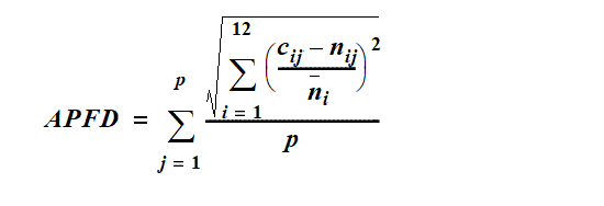
p means the number of years.
cij means the modelled flow for month i in year j.
nij means the modelled natural flow for month i in year j.
ni means the modelled natural flow for month i across p years.
sch 11A ins 2007 SL No. 343 s 11
1.5 year daily flow volume means the daily flow that has a 67% probability of being reached at least once a year.
5 year daily flow volume means the daily flow that has a 20% probability of being reached at least once a year.
20 year daily flow volume means the daily flow that has a 5% probability of being reached at least once a year.
50% daily flow, for a month, means the flow, in megalitres, that is equalled or exceeded on 50% of days in the month in the simulation period.
90% daily flow, for a month, means the flow, in megalitres, that is equalled or exceeded on 90% of days in the month in the simulation period.
95% unsupplemented water sharing index, for a group of authorisations, means the total volume of water simulated to have been taken annually under the authorisations in at least 95% of years in the simulation period, if the authorisations were in existence for the whole of the simulation period, expressed as a percentage of the simulated mean annual diversion for the authorisations.
adopted middle thread distance means the distance in kilometres, measured along the middle of a watercourse, that a specific point in the watercourse is from—
(a)the watercourse’s mouth; or
(b)if the watercourse is not a main watercourse—the watercourse’s confluence with its main watercourse.
AMTD means adopted middle thread distance.
annual proportional flow deviation, for a node, means the statistical measure of changes to flow season and volume in the simulation period, at the node, calculated using the formula in schedule 11A.
sch 12 def annual proportional flow deviation sub 2007 SL No. 343 s 12(1)–(2)
annual variability, for a flow at a point in a watercourse, means the amount of change in the flow that happens between years.
annual volumetric limit, for a water entitlement, means the maximum volume of water that may be taken under the water entitlement in a water year.
artesian water means water that occurs naturally in, or is introduced artificially into, an aquifer, which if tapped by a bore, would flow naturally to the surface.
sch 12 def artesian water ins 2016 SL No. 216 s 146 sch 20
authorisation means a licence, permit, interim water allocation or other authority to take water given under the Act or the repealed Act, other than a permit for stock or domestic purposes.
Cooloola Sandmass subartesian area see section 5.
critical water supply strategy ...
sch 12 def critical water supply strategy om 2014 SL No. 142 s 164(1)
daily flow, for a place, means the volume of water that flows past the place in a day.
discharge, for a flow at a point in a watercourse, means the rate at which water passes the point, measured in cubic metres a second or megalitres a day.
ecological assets include a species, a group of species, a biological function, an ecosystem and a place of natural value.
event duration, for a flow at a point in a watercourse, means the period of time when the discharge is greater than or less than the level necessary for a particular ecological process to happen.
flow regime means the entire range of flows at a point in a watercourse including variations in the watercourse height, discharge, seasonality, annual variability and event duration.
flow regime class means the measure of flow regime seasonality worked out using the method stated in Haines, A.T., Finlayson, B.L. and McMahon, T.A., ‘A global classification of river regimes. Applied Geography, 1988’.
groundwater means underground water.
sch 12 def groundwater sub 2016 SL No. 216 s 146 sch 20
hydraulic habitat requirements, of an ecological asset, are the hydraulic or physical attributes of the flow regime that are—
(a)required for a particular biological process or response to happen in relation to the asset; or
(b)necessary to maintain the long-term biological integrity of the asset.
infrastructure operating rules means, for infrastructure to which the resource operations plan applies, the infrastructure operating rules included in the resource operations plan.
IQQM computer program means the department’s Integrated Quantity and Quality Modelling computer program, and associated statistical analysis and reporting programs, that simulate daily stream flows, flow management, storages, releases, instream infrastructure, water diversions, water demands and other hydrologic events in the plan area.
late summer flow regime class see the Pioneer Valley Water Resource Plan Environmental Flow Report, December 2001.
A copy of the report may be inspected at the department’s head office, Brisbane.
sch 12 def late summer flow regime class amd 2007 SL No. 343 s 12(3)
low flow duration (10cm above cease-to-flow), for a watercourse, means the percentage of the total number of days in the simulation period that the watercourse’s daily flow is at least 10cm above the cease-to-flow level in the watercourse.
low flow duration (30cm above cease-to-flow), for a watercourse, means the percentage of the total number of days in the simulation period that the watercourse’s daily flow is at least 30cm above the cease-to-flow level in the watercourse.
low flow regime, for a watercourse, means the minimum flows that provide a continuous flow through the watercourse.
maximum daily volume, for a water entitlement, means the maximum volume of water that may be taken under the entitlement in a day.
mean annual flow means the total volume of flow in the simulation period divided by the number of years in the simulation period.
mean unsupplemented water sharing index, for a group of water allocations, means the average total volume of water simulated to have been taken annually under the allocations in the simulation period, if the allocations were in existence for the whole of the simulation period.
monthly supplemented water sharing index, for water allocations to take supplemented water in a water supply scheme, means the percentage of months in the simulation period in which the allocations are fully supplied.
node see section 8.
plan area means the area shown as the plan area on the map in schedule 1.
pre-development flow pattern means the pattern of water flows, during the simulation period, decided by the chief executive using the IQQM computer program as if—
(a)there were no dams or other water infrastructure in the plan area; and
(b)no water was taken under authorisations in the plan area.
priority area see section 87.
related development permit, for an authorisation, means the development permit for the works for taking water under the authorisation.
resource operations plan means the resource operations plan to implement this plan.
See the Act, section 1266.
sch 12 def resource operations plan amd 2016 SL No. 216 s 146 sch 20
seasonality, for a flow at a point in a watercourse, means the time of year when the flow happens.
SEQ regional plan means the regional plan under the Planning Act for the region named the SEQ region under the Planning Regulation 2017.
sch 12 def SEQ regional plan sub 2009 SL No. 280 s 186; 2017 SL No. 103 s 162
simulated mean annual diversion, for water allocations in a subcatchment area, means the total volume of water simulated to have been taken under the allocations, if the allocations were in existence for the whole of the simulation period, divided by the number of years in the simulation period.
simulation period means the period from 1890 to 1999.
subartesian water means water that occurs naturally in, or is introduced artificially into, an aquifer, which if tapped by a bore, would not flow naturally to the surface.
sch 12 def subartesian water ins 2016 SL No. 216 s 146 sch 20
subartesian works means—
(a)a subartesian bore; and
(b)pumping and other equipment to take water from the bore.
subcatchment area see section 6.
supplementation point, for a watercourse, means the most upstream point on the watercourse at which the natural flow of water in the watercourse is supplemented by water from a dam or weir.
supplemented water means water supplied under an interim resource operations licence, resource operations licence or other authority to operate water infrastructure.
surface water see section 9.
this plan means this water resource plan.
traditional owners, of an area, means the Aboriginal people who identify as descendants of the original inhabitants of the area.
unsupplemented water means water that is not supplemented water.
water flow season means any of the following periods in a year—
(a)the period from 1 February to 30 April (Feb–April water flow season);
(b)the period from 1 May to 31 July (May–July water flow season);
(c)the period from 1 August to 30 November (Aug–Nov water flow season);
(d)the period from 1 December to 31 January (Dec–Jan water flow season).
sch 12 def water flow season ins 2014 SL No. 142 s 164(2)
water supply scheme means a water supply scheme described in schedule 11.
water year, for water taken under a water entitlement, means the water year for the resource operations plan.
sch 12 def water year ins 2007 SL No. 343 s 12(2)